Article

Depositional Model for the Early Triassic Braided River Delta and Controls on Oil Reservoirs in the Eastern Junggar Basin, Northwestern China

1
Xinjiang Key Laboratory for Geodynamic Processes and Metallogenic Prognosis of the Central Asian Orogenic Belt, Xinjiang University, Urumqi 830017, China
2
School of Geology and Mining Engineering, Xinjiang University, Urumqi 830017, China
3
Zhundong Oil Production Plant of PetroChina Xinjiang Oilfield Company, Fukang 831500, China
*
Author to whom correspondence should be addressed.
Minerals 2022, 12(11), 1409; https://doi.org/10.3390/min12111409
Submission received: 25 September 2022 / Revised: 30 October 2022 / Accepted: 3 November 2022 / Published: 5 November 2022
(This article belongs to the Section Mineral Deposits)

Abstract

:
The Triassic Jiucaiyuan Formation is a vital oil and gas exploration target in the eastern part of the Junggar Basin. In this work, cores, thin sections, particle sizes, and conventional physical properties were analyzed in order to understand the sedimentary characteristics and depositional model of the Jiucaiyuan Formation in the Beisantai Uplift and to clarify the factors controlling reservoir development. The results demonstrate that the Jiucaiyuan Formation can be divided into seven lithofacies, namely massive bedding gravel, massive bedding sandstone, trough bedding sandstone, plane bedding sandstone, wavy bedding sandstone, parallel bedding siltstone, and massive bedding mudstone. Braided river delta facies dominate the Jiucaiyuan Formation. Nine main subtypes of facies were observed: flood plain, braided channel above lake level, natural levees above lake level, braided channel under lake level, interdistributary bays, natural levees under lake level, mouth bars, prodelta mud, and beach bar. The braided channel under lake level, mouth bar, and beach bar reservoirs exhibited the best physical properties, with average porosities of 16.54%, 19.83%, and 20.41%, respectively, and average permeabilities of 3.43 mD, 9.91 mD, and 12.98 mD, respectively. The physical properties of reservoirs in the study area are mainly controlled by sedimentation. Braided channels under lake level, mouth bars, and beach bars are favorable facies for the development of high-quality reservoirs. The results of this study are expected to serve as a theoretical basis for further exploration and development of oil and gas in the study area.

1. Introduction

The global demand for energy has increased exponentially in recent years, triggering the need to expand oil exploration and develop new drillcores [1]. Large oil and gas fields are primarily related to delta sand bodies [2,3,4,5], so improving our knowledge of the lithofacies types and depositional environment of clastic reservoirs is crucial to understand reservoir quality and for exploration and development.
The Junggar Basin is an important petroliferous basin in northwestern China; its eastern exploration area measures approximately 2.4 × 10⁴ km2. Since the commencement of exploration, seven oil and gas fields, including Huoshaoshan and Beisantai, have been successfully discovered in this area. The proven reserves in this area account for 20% of the reserves in the entire basin, making it a vital oil-producing area [6,7]. In 2005, more than 20 exploratory drillcores were drilled in the Triassic Shaofanggou and Jiucaiyuan formations, and oil and gas drillcores were developed [8]. For example, the oil test in the 2165–2283 m section of the BH-3 drillcore in the Jiucaiyuan Formation yielded cumulative oil production of 16.94 m3, confirming the oil and gas exploration potential in the Triassic strata of the Beisantai Uplift area [9,10,11]. Previous studies on the sedimentary facies, depositional environment, and sedimentary evolution process of the Triassic strata in the study area show that the area has complex rock types and primarily exhibits a river-delta depositional system [10]. However, current research on the factors controlling the oil and gas reservoirs in the Jiucaiyuan Formation in the study area is mainly focused on favorable diagenesis [12,13,14,15]; this approach does not meet the actual needs of oilfield exploration and development. Therefore, it is necessary to study the controlling factors of oil and gas reservoirs in the Jiucaiyuan Formation from the perspective of sedimentation.
Lithofacies is the first element studied in analysis of the process of sediments formation, and it is also the basic work of sedimentary facies research. Miall first introduced the lithofacies concept in 1977 [16], stating that a lithofacies is a rock or a combination of rocks formed in a particular depositional environment. Studying the lithofacies types provides insights into the influence of sedimentary structure, hydrodynamic conditions, and mineral particle size on the reservoir [17]. Previous studies have proved that the reservoir sand bodies of the Jiucaiyuan Formation in the study area mainly consist of a braided channel above lake level facies [11,18]. However, owing to the great thickness of the sandstones in the Jiucaiyuan Formation as well as the complex lithology and significant horizontal and vertical changes in the formation, the reservoir quality of different lithofacies and facies in the formation vary greatly, and our understanding of the reservoir properties of different sedimentary facies is not sufficiently precise. Therefore, it is necessary to study the influence of sedimentary characteristics on reservoir properties. In this study, a detailed analysis of the sedimentary characteristics of the Jiucaiyuan Formation in the Beisantai area was performed. Core samples and data on reservoir physical properties from 26 coring drillcores of the Jiucaiyuan Formation were studied. Thin section analysis and physical analysis were systematically performed to elucidate the lithofacies types, lithofacies combinations, and their constraints on reservoir formation. The research understanding provides specific theoretical support for the horizon optimization of oil and gas exploration and the next exploration deployment in the study area.

2. Geological Setting

The Junggar Basin is a large oil- and gas-bearing basin located in northern Xinjiang and bounded by the Tianshan Mountain, Zaire Mountain, and Altai Mountain. The basin is triangular in a plan view, being wide in the south and narrow in the north. The target region in this study is located east of the Junggar Basin and south of the Tianshan Mountain (Figure 1a) [19,20,21]. It is bounded by Jimusar County to the east and Fukang County to the west and occupies an area of approximately 234 km2.
Structurally, the Beisantai area is located at the intersection of the central depression and the eastern uplift in the Junggar Basin. The northern portion is near to the Shaqi Uplift, and the southern portion is connected to the Fukang fault zone and the Bogeda Mountain. The eastern portion is adjacent to the Jimusar Sag, and the western portion is adjacent to the Fukang Sag (Figure 1b). The area appears in the form of a large nose [22,23,24]. The southern part of the area is adjacent to the Bogeda orogenic belt, and its formation and evolution are closely related to the multistage uplift of the orogenic belt. At the end of the late Carboniferous, the Tarim Plate collided with the Junggar Block, resulting in the closure of the Bogeda rift zone [25]. At the end of the Early Permian, with the beginning of the Bogeda Mountain orogeny, the Beisantai Uplift began to develop. During the Triassic, the Bogeda Mountain orogeny entered the late stage, resulting in a substantial uplift of the Beisantai Uplift [10].
The basement of the Junggar Basin has a double-layer structure. The lower layer is the Lower Cambrian crystalline basement, and the upper layer is the Early-Middle Hercynian folded basement. The stratigraphic development of the basin is complex [26]. A thick sedimentary cover developed on the double-layer basement from the Late Carboniferous to the Quaternary. The Triassic succession in the study area is divided into four formations from bottom to top, namely the Jiucaiyuan, Shaofanggou, Karamay, and Huangshanjie (Figure 1c). The Jiucaiyuan Formation in the Beisantai Uplift is the target of this study. Based on the lithological characteristics, the Jiucaiyuan Formation can be divided into a lower member (Member I) and an upper member (Member II). Member I mainly consists of siltstone, sandstone, and mudstone with an average thickness of approximately 100 m, whereas Member II mainly consists of sandstone, siltstone, and mudstone with an average thickness of approximately 140 m [8].
Figure 1. Present locations and composite stratigraphic columnar section of the Jiucaiyuan Formation in the Beisantai Uplift, eastern Junggar Basin. (a) Regional index map (after Zhang [27]). (b) Structural trend of the Jiucaiyuan Formation and some drilling positions (after He et al. [28]). (c) Stratigraphic column of the Jiucaiyuan Formation in the Beisantai Uplift, eastern Junggar Basin (after Zhang [27]; Cohen et al. [29]).
Minerals 12 01409 g001

3. Sampling and Methods

Based on core data of the Jiucaiyuan Formation, the cores from 26 coring drillcores were observed and described in detail during this study (Figure 1b), and samples were prepared for the following tests: (1) Dyed casting thin section analysis: more than 50 representative rock samples in the study area were uniformly ground into dyed casting thin sections with a thickness of 0.03 mm, filled with blue epoxy resin to highlight the pores in the rocks, and dyed with alizarin red to highlight the carbonate minerals in the rocks. An electron microscope (Carl Zeiss Axio Scope A1) was used to observe the characteristics of the minerals and pores of the samples. (2) X-ray diffraction (XRD) analysis: XRD whole rock analysis was used to identify the mineral types and their contents in the samples. A total of 14 representative rock samples were collected, and the mineral types and contents of the rocks were determined using an XPert Powder X-ray diffraction analyzer, with a scanning speed of 2°/min (2θ) and a scanning range of 5–45° (2θ). The test served as a basis for reservoir analysis of the Jiucaiyuan Formation. (3) Porosity and permeability tests: A total of 46 samples from coring drillcores were selected for routine analysis of physical properties, and cylinders (diameter: 2.5 cm; length: 5 cm) were prepared. Two parameters, porosity and permeability, were determined using an AP-608 overburden porosimeter at Xinjiang Key Laboratory for Geodynamic Processes and Metallogenic Prognosis of the Central Asian Orogenic Belt. The results served as a basis for reservoir analysis of the Jiucaiyuan Formation. (4) Lithofacies analysis: lithology, particle size, sedimentary structure, and color are the primary characteristics used to identify lithofacies. With reference to Miall’s method of dividing river sediments into 22 lithofacies [30], the lithofacies of the Jiucaiyuan Formation in the study area were identified based on detailed observations and descriptions of coring drillcores, as well as named using the format “sedimentary structure + lithology”. In all, a total of seven lithofacies types and nine lithofacies combinations were identified.

4. Results

4.1. Petrological Characteristics

The rock types of the Jiucaiyuan Formation are complex and diverse, consisting of gravel, sandstone, siltstone, and mudstone (Figure 2). Observations of cores from several coring drillcores in the Jiucaiyuan Formation revealed abundant sedimentary structures, including parallel bedding, wavy bedding, trough cross-bedding, scouring surface structures, and massive structures (Figure 2g–l; Table 1). Two types of cumulative curves of particle size probability, (i.e., two-section and three-section) were identified by analyzing the particle size data of the coring sections of the Jiucaiyuan Formation (Figure 3).

4.1.1. Rock and Mineral Characteristics

The lithology of the Jiucaiyuan Formation in the Beisantai Uplift consists mainly of pebbly sandstone, sandstone, siltstone, and mudstone; gravel can be found in the sandstones (Figure 2). The pebbly sandstone exhibits poor sorting and subangular to subrounded particles, with mainly point or line contacts between particles; the gravel diameter exceeds 3 mm, the pebbly sandstone is dominated by fragments, and the quartz is subangular. The sandstone contains subangular particles with sizes of 0.1–0.3 mm; it exhibits poor to medium sorting and intergranular type pores (Figure 2a–d). The siltstone exhibits better sorting, and subrounded to rounded particles (Figure 2e,f). The mudstone exhibits brown and gray colors.
Based on whole rock analysis and identification data of 14 blocks in the study area, it was concluded that the rock types of the Jiucaiyuan Formation were dominated by litharenites and feldspathic litharenites, as detailed in Folk’s classification scheme (Figure 3) [31]. The average contents of quartz, feldspar, and lithic fragments were 15.3%, 27.6%, and 57.1%, respectively. The content of feldspar and unstable lithic components was high (Figure 3). The sand particles were poorly rounded (i.e., subangular to subrounded) and poorly to moderately sorted, and they exhibited low compositional and textural maturity (Figure 2a–c), indicating that the sediments of the Jiucaiyuan Formation underwent short migration paths in the study area.

4.1.2. Sedimentary Structures

Abundant sedimentary structures, including parallel bedding, wavy bedding, plane bedding, scouring surface structures, and massive structures, have been identified through observations of cores from several drillcores in the Jiucaiyuan Formation in the study area (Figure 2g–l). Trough bedding and surface structures are common in gravelly sandstone and coarse sandstone, indicating that the channel often oscillated laterally, and reflecting the stable hydrodynamic conditions during deposition (Figure 2g,l). Parallel bedding mainly occurs in fine-grained sandstone, indicating deposition under water with high kinetic energy (Figure 2h). Wave bedding is mainly developed in sandstone and siltstone and is formed under wave action (Figure 2i). Plane bedding typically occurs in pebbly sandstone and is formed by flow and lateral accretion (Figure 2j). Massive structures are developed in sandstone and mudstone; the massive bedding in sandstone demonstrates poor sorting, reflecting the rapid accumulation of sediments (Figure 2k).

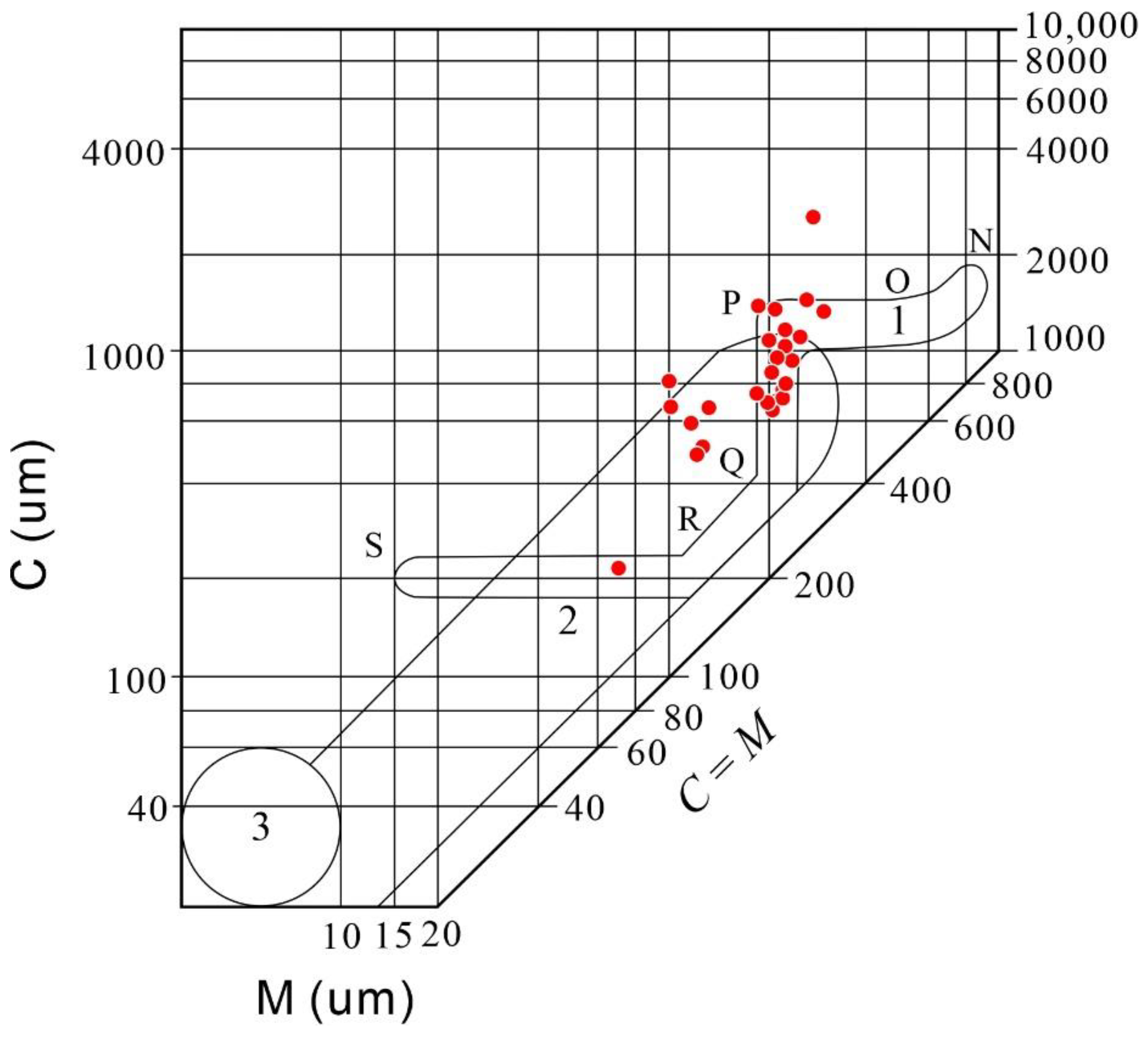
4.1.3. Particle Size Characteristics

Based on the analysis of the particle size data from the core section of the Jiucaiyuan Formation in the study area, two types of cumulative curves of particle size probability were identified (Figure 4). The curves are characterized by coarse particle sizes and wide particle size distribution intervals. The first type of cumulative curve of particle size probability is the three-section type. The rolling, jumping, and suspension subsections are well-developed in this type of curve. The point of intersection between the jumping and suspension sections of the curve is 0–2 Φ, and the sorting is good (Figure 4a). The second type of cumulative curve of particle size probability is the two-section type, with noticeable overall jump and suspension sections (Figure 4b). The overall content of the jump section is approximately 40%, and the sorting is relatively good. The overall sorting of the suspension section is poor. The S-cut point is located roughly at −1 Φ (Figure 4b). This is mainly developed in conglomerate and gravel-bearing sandstones.
The particle size distribution characteristics can clarify the hydrodynamic conditions during sedimentation and can provide a basis for analysis and comparison of depositional environments [32]. A C-M diagram was prepared on the basis of the particle size analysis data of cores from the Jiucaiyuan Formation in the Beisantai Uplift; the C value was 200~3500 μm, and the M value was 65~400 μm, reflecting strong hydrodynamic conditions (Figure 5). The sample data point group mainly plots in the PQ-PO section, which is a typical C-M diagram of traction current deposition (Figure 5). Taken together, the characteristics of the sedimentary structure and particle size distribution indicate that the Jiucaiyuan Formation in the Beisantai Uplift is a traction current deposit (Figure 2 and Figure 4). The characteristics indicate that the sediments in the study area originate from a source region that is relatively close by, and the hydrodynamic characteristics are those of stable flow and a sufficient degree of scouring due to a transportation over a certain distance.

4.2. Physical Reservoir Properties

4.2.1. Pore Space Characterization

Casting thin section studies show that the types of reservoir spaces in the Jiucaiyuan Formation in the study area are diverse. Reservoir spaces consist mainly of primary and secondary porosity (Figure 6). Primary pores are intergranular pores, whereas secondary pores include dissolution pores, intergranular pores, microcracks, and other such voids.
Primary intergranular pores are distributed between particles and not filled by cement (Figure 6a,b); these constitute the main type of reservoir spaces in the study area. Dissolution pores are formed due to selective dissolution of large clastic particles (e.g., feldspar and rock fragments) by underground fluid flowing along the interfaces of these particles. Dissolution pores are the most common secondary pores in the study area (Figure 6c–f). Intergranular pores are microcrystalline pores that develop between the crystals of clay mineral cements (Figure 6g–i). These pores have no noticeable effect on the promotion of seepage and stagnant water films are often formed in these pores, resulting in the reduction of reservoir permeability. Microfractures are formed due to the fracturing of sandstone under the action of external forces and lead to substantial heterogeneity in the reservoir. The fractures in the study area account for a small proportion of the total pore volume of rock; they do not have an appreciable influence on the reservoir spaces, but they can effectively improve the reservoir permeability. The microfractures found in the sampled sandstone were approximately 0.01–0.05 mm wide (Figure 6j,l).

4.2.2. Porosity and Permeability

On the whole, the sandstone in the Jiucaiyuan Formation reservoir exhibits good physical properties (Figure 7). Statistical analysis of porosity data from 118 samples shows that the minimum, maximum, and average porosity values are 1.30%, 27.67%, and 16.37%, respectively. The data points are mainly distributed between 12% and 24% (Figure 7a). Analysis of permeability data from 115 samples shows that the minimum, maximum and average values of permeability are 0.01 mD, 142.00 mD, and 14.63 mD, respectively. The data points are mainly distributed between 1 and 81 mD, and the prominent peak occurs between 1 and 9 mD (Figure 7b).

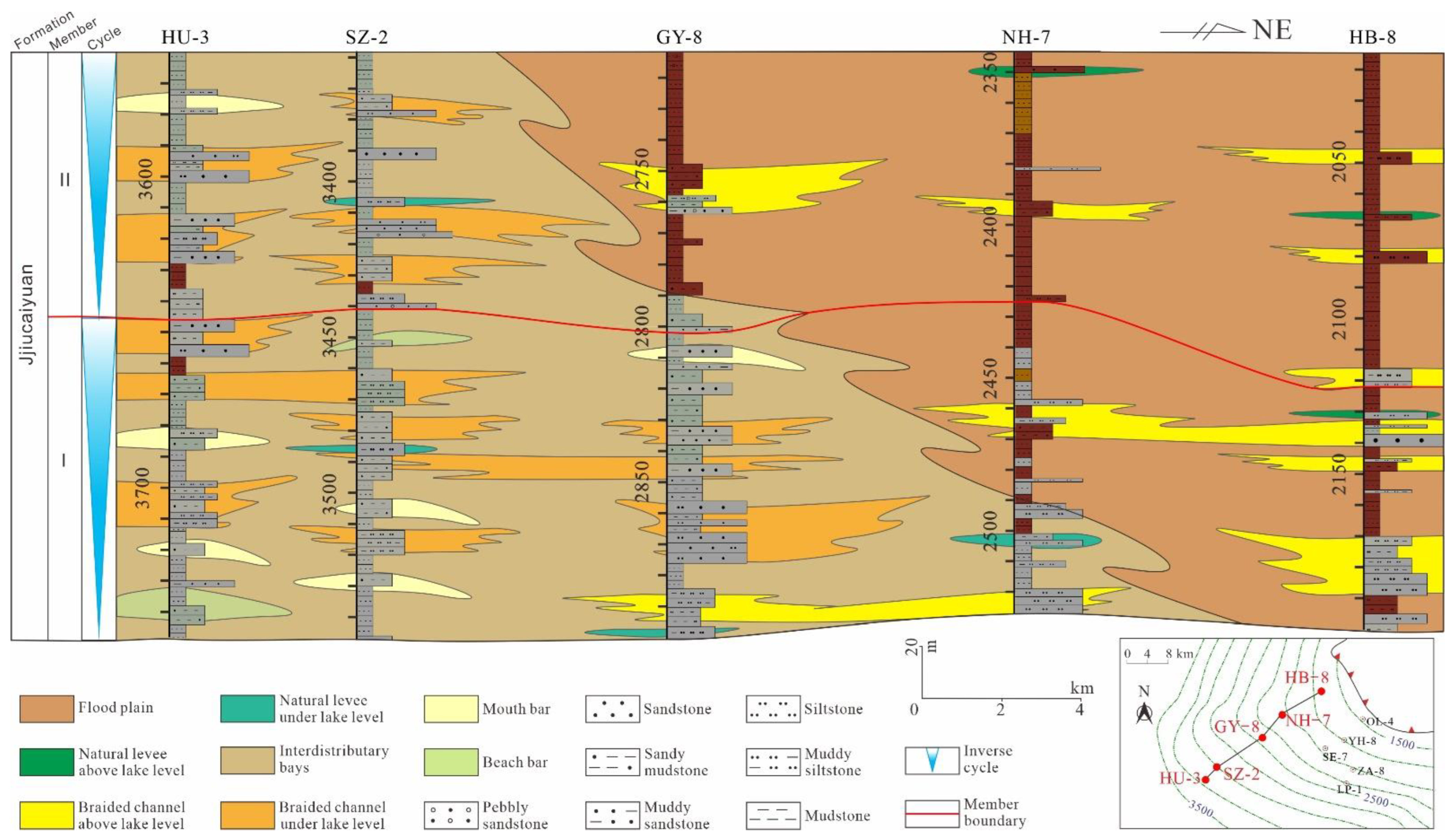
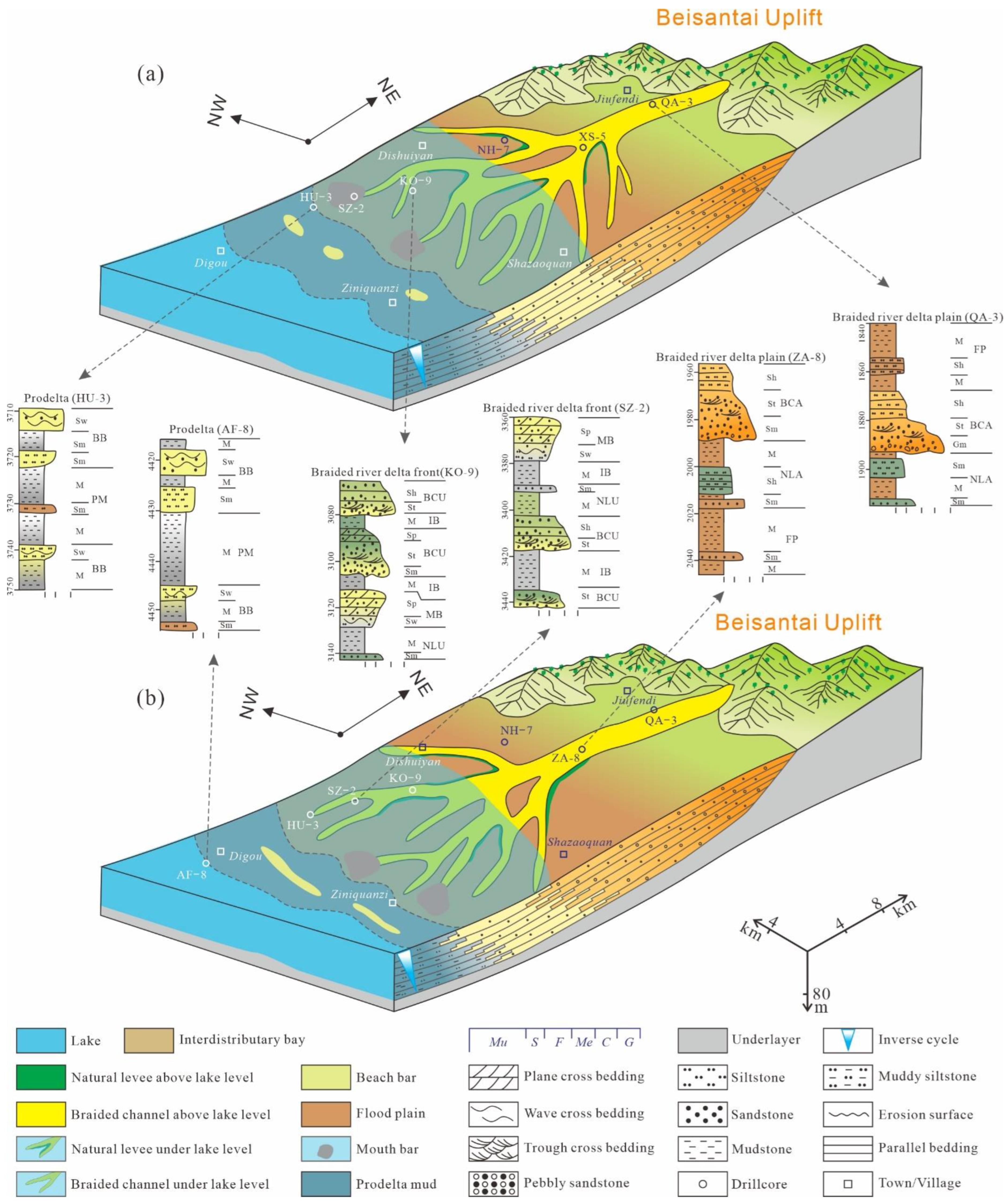
4.3. Sedimentary Systems

The sedimentary system refers to the three-dimensional lithofacies association genetically related to the depositional environment and process [33]. Based on the aforementioned analysis of the petrological characteristics, observations of cores indicate that the Jiucaiyuan Formation can be divided into seven lithofacies and nine facies. Combined with the analysis of drillcores transects, the sedimentary systems of the Jiucaiyuan Formation were established (Table 1; Figure 8).

4.3.1. Types and Characteristics of Lithofacies

Based on core and thin section observations, Miall’s lithofacies division method was applied for the Jiucaiyuan Formation in the study area [30]. According to the lithology and sedimentary structure of the study area, the Jiucaiyuan Formation can be divided into seven lithofacies (Table 1). (1) Massive bedded mudstone is composed of brown and gray mudstones, deposited in a relatively low-energy environment, and is the product of the unloading of fine-grained suspended sediment (Table 1). (2) Parallel bedding siltstone is composed of fine-grained sandstones with good rounding and sorting, and exhibits parallel bedding, which is typical of sand bodies deposited under strong flow conditions, indicating that the depositional environment was relatively stable and the hydrodynamic force was strong at the time of formation (Figure 2h; Table 1). It is the product of shallow and rapid water flow. (3) Wavy bedded sandstone is composed of medium-grained sandstones and fine-grained sandstones with good roundness and sorting (Figure 6c). Wavy bedding is developed by wave washing and transformation (Figure 2i; Table 1). (4) Plane bedding sandstone is composed of medium-grained sandstones with medium rounding and medium sorting (Figure 6g). It develops plane-shaped cross-bedding, formed by downstream or lateral accretion (Figure 2j; Table 1). (5) Trough bedding sandstone is composed of coarse sandstones with medium rounding and poor sorting (Figure 6a). Small trough bedding is developed (Figure 2g). The channel undercut, migration, and filling deposition is indicative of the frequent undercutting and migration of the channel and vigorous scouring (Table 1). (6) Massive bedding gravel is composed of angular to subangular sandstones with poor sorting (Figure 6l). Massive bedding is developed, reflecting strong hydrodynamic forces during formation (Figure 2k; Table 1). (7) Massive bedding gravel is composed of angular, poorly-sorted, massive, and disorderly accumulated gravels, usually formed by river channel scouring, reflecting continuous changes in the water flow direction (Figure 6j). The river channel is strongly incised and subsequently filled, and this lithofacies consists of the gravel deposit retained at the bottom of the braided river channel (Figure 2l; Table 1).

4.3.2. Lithofacies Association and Subenvironments

According to the seven lithofacies identified above, typical lithofacies associations were observed and statistically analyzed to establish a braided river delta sedimentary system. The braided river delta sedimentary system comprises the braided river delta plain, braided river delta front, and pre-delta subenvironments (Figure 8).
(1)
Braided river delta plain
Braided river delta plain subenvironment is influenced primarily by rivers and by lakes to a lower degree [33,34]. The lithology mainly comprises conglomerate (Figure 2l and Figure 8), gravelly sandstone (Figure 8), and sandstone (Figure 2g–k and Figure 8), and the main structures developed are plane bedding (Table 1; Figure 2h and Figure 8) and trough bedding (Table 1; Figure 2g and Figure 8). Three facies exist in the braided river delta plain of the Jiucaiyuan Formation in the study area, namely flood plain, braided channel above lake level, and natural levees above lake level (Figure 8, Figure 9 and Figure 10).
  •  
    (a)
    Flood plain
The flood plain sediments are composed of reddish-brown mud and silt, mainly forming mudstone, with sand bodies primarily in the form of thin layers sandwiched between mudstones and exhibiting blocky and parallel bedding [33]. This facies primarily comprises parallel bedding siltstone (Figure 2h and Figure 8) and massive bedding mudstone (Figure 8). The red mudstone in the flood plain indicates a hot and dry paleoclimate or an exposed environment [35].
  •  
    (b)
    Braided channel above lake level
The braided channel above lake level is the most developed facies in the delta plain subenvironment, mainly consisting of fine-grained gravels, with an apparent upward fine-grain sequence and asymmetric binary structure [33]. Massive bedding gravel is deposited at the bottom (Figure 2l and Figure 8), which is in contact with the lower sediments in an erosion surface. With the gradual stabilization of hydrodynamic conditions, the river channel above lake level oscillated and underwent downcutting, and the large trough sandstone (Table 1; Figure 2g and Figure 8) and parallel bedding siltstone (Figure 2h and Figure 8) were formed. The sandstone is poorly sorted, with subangular to angular particles, and has a high matrix content (Figure 2d and Figure 6c–h).
  •  
    (c)
    Natural levee above lake level
Natural levees above lake level are sand bars formed by the fine-grained and very fine-grained sand fragments carried by river water that overflows the river banks and accumulates along both banks of the river [33]. The natural levees above lake level are composed of gray-green and red siltstone (Figure 8 and Figure 9), and the main lithofacies are massive bedding mudstone (Figure 8, Figure 9 and Figure 10) and massive bedding sandstone (Figure 2k, Figure 8, and Figure 10). The thickness of natural levee sand bodies above lake level is generally 1–2 m. Natural levee sediments are located on both sides of the braided channel above lake level.
(2)
Braided river delta front
The braided river delta front subenvironment occurs in the area from the outer edge of the delta plain to the lake, which is below the lake level; sand-mud deposition in the delta front area is controlled by rivers and lakes [36]. Four facies exist in the braided river delta front, namely braided channels under lake level, natural levees under lake level, interdistributary bays, and mouth bars (Figure 8, Figure 9 and Figure 10).
  •  
    (a)
    Braided channel under lake level
The braided channel under lake level is the extension of the braided channel above lake level in the downstream portion of the delta plain; it is affected by high energy currents. Because a braided channel above lake level rarely suffers from the transformation of channel sand by external factors, the erosion surface at the bottom of the channel is clear and the lithology is mostly conglomerate. A braided channel under lake level is transformed by lake water, so the erosion surface is weaker than the distributary channel, and the bottom of the channel is mostly sandstone [37,38]. It is composed of gray-green sandstone (Figure 2h), and the main lithofacies include parallel bedding siltstone (Figure 2h and Figure 8), trough bedding sandstone (Figure 2g and Figure 8), plane bedding sandstone (Figure 2j and Figure 8), and massive bedding gravel (Figure 2l and Figure 8). The sandstone exhibits medium sorting and subangular to subrounded particles, and the matrix content is medium (Figure 2a,d and Figure 6d–f).
  •  
    (b)
    Natural levee under lake level
An underwater natural levee is an underwater extension of the natural levee above the water level. It is a sand ridge of fine-grained sand and silt that accumulates on both sides of the braided channel under lake level [33]. The sediments consist of gray-green fine-grained sand and silt (Figure 2h and Figure 8). The main lithofacies are massive bedding mudstone (Figure 8) and massive bedding sandstone (Figure 2k and Figure 8). The sandstone exhibits medium sorting and subangular to subrounded particles, and the matrix content is medium (Figure 2d–f and Figure 6g–i).
  •  
    (c)
    Interdistributary bay
The distributary channel is a relatively low-lying area between braided channels under lake level. It mainly consists of mudstone and siltstone, and is developed chiefly with massive bedding. Owing to changes in water level in shallow lakes and the reduction of the oxygen content in water, the mudstone in the delta front is mostly gray [33]. The main lithofacies are massive bedded mudstone (Figure 8) and massive bedded sandstone (Figure 2k and Figure 8).
  •  
    (d)
    Mouth bar
The sand body of the estuarine levee at the front edge of the delta develops in the estuary near the end of the braided channel under lake level [33]. The facies consist of parallel bedded siltstone (Figure 2h and Figure 8), plane bedded sandstone (Figure 2j and Figure 8), wavy bedded sandstone (Figure 2i and Figure 8), and massive bedded sandstone (Figure 2k and Figure 8). Mouth bar sediments are in contact with the underlying prodelta mud. The sandstone exhibits good sorting, with subrounded to rounded particles, and the matrix content is low (~ 5%) (Figure 2b).
(3)
Prodelta
The prodelta subenvironment is located in front of the leading edge of the delta, and most of its sediments are formed below the wave base level [33]. It is mainly composed of dark mudstone and silty mudstone, with a small amount of sandstone (Figure 8, Figure 9 and Figure 10). The prodelta subenvironment includes two kinds of facies: prodelta mud and beach bar (Figure 8, Figure 9 and Figure 10).
  •  
    (a)
    Prodelta mud
The prodelta mud is located in the front of the delta front, and its sediment-carrying capacity is weak [39]. It is dominated by gray mudstone and silty mudstone, with a few thin siltstone layers (Figure 8). The thickness of individual layers is 1–5 m, and massive bedding is dominant (Figure 2k and Figure 8).
  •  
    (b)
    Beach bar
Beach bar is the general term for thinly layered beach sand, and thickly layered bar sand developed in the delta front or prodelta region due to the continuous influence of bank currents and waves [40,41,42,43]. The sediments consist of interbedded siltstone and mudstone (Figure 8). The facies includes massive bedded mudstone (Figure 8), wavy bedded sandstone (Figure 2i and Figure 8), and massive bedded sandstone (Figure 2k and Figure 8). The sandstone particles are well sorted and rounded, and the matrix content is low (~5%) (Figure 2e–f and Figure 6b). Wavy bedding and cross-bedding are typical characteristics of this facies (Figure 2g,i and Figure 8).

5. Discussion

5.1. Depositional Model

The Junggar Basin was located in Laurasia (a paleolatitude of ~45° N) during the Triassic [44,45], close to the ocean, and had a warm and humid paleoclimate [46]. Furthermore, several species of well-preserved pollen-bearing plants have been identified at the bottom of the Jiucaiyuan Formation, indicating that the paleoclimate during the Early Triassic was subtropical, warm, and humid [47]. The average values of the Chemical Index of Alteration (CIA) and Plagioclase Index of Alteration (PIA) of the Jiucaiyuan Formation are 72.14 and 85.39, respectively, indicating that its chemical weathering degree is moderate to strong [48]. The average value of Mg/Ca was 2.09, indicating that the paleoclimatic condition of the Jiucaiyuan Formation was semi-humid to humid [48].
According to the above comprehensive characteristics, the Jiucaiyuan Formation in the Beisantai Uplift was in a semi-humid climate, the material supply of the Beisantai Uplift in the northeast was sufficient, and the topography was high in the northeast and low in the southwest [5]. These factors provided the conditions for the development of a braided river delta. The sedimentary period of the study area is relatively close to the provenance region, with hydrodynamic characteristics of stable water flow scouring and full elutriation, rich structure formed by strong hydrodynamic force in the rock core and particle size characteristics of traction flow deposition, which indicates that the Jiucaiyuan Formation in the study area is a braided river delta depositional environment.
On the basis of single-well facies analysis, multi-well profile facies analysis, and provenance analysis [9], the braided river delta depositional model of the Jiucaiyuan Formation was established. Both Member I and Member II of the Jiucaiyuan Formation represent inverse cycles, and the formation represents progradation as a whole. Drillcores HB-8, NH-7, and GY-8 mainly exhibit the braided river delta plain subenvironment, as their sediments originate in Beisantai to the north. The mudstones are primarily brown and mainly formed in an oxidizing environment. Compared with Drillcores HB-8 and NH-7, Drillcore GY-8 mainly exhibits the braided river delta front subenvironment in Member I and the braided river delta plain subenvironment in Member II. Drillcores HU-3 and SZ-2 mainly exhibit the braided river delta front subenvironment, with mainly gray mudstone and a primarily reducing environment; the braided river channel under lake level and estuary bar facies are dominant in these drillcores (Figure 9).
During the deposition period of the Jiucaiyuan Formation, the terrain was high in the northeast and low in the southwest. The sediments originated from the Beisantai Uplift in the northern part of the study area [14]. Owing to the supply of sediment from the Beisantai Uplift, the river channel was oriented northeast–southwest. Due to proximity of the sediment source region, the lithology of the Jiucaiyuan Formation is dominated by gravel sandstones and sandstones. The sedimentary structure is dominated by massive bedding and trough bedding, indicating stable hydrodynamic conditions, and the river channel constantly changed and underwent bifurcation. From the Permian to the end of the Cretaceous Period, the Junggar Basin was located near the 45° N paleolatitude, close to the ocean; the paleoclimate was warm and humid [46]. Furthermore, several species of well-preserved pollen-bearing plants have been identified at the bottom of the Jiucaiyuan Formation, indicating that the paleoclimate during the Early Triassic was subtropical, warm, and humid [47]. As a consequence of the prevailing paleoclimate, the braided river delta plain of the Jiucaiyuan Formation primarily developed the flood plain facies, with lithology consisting mainly of thick red-brown mudstone. In general, the period of deposition of Member I and Member II was one of continuous regression, and the delta deposits extend towards the depositional center (Figure 10).
The braided river delta of the Mungaroo Formation developed in the North Carnarvon Basin on the southern Northwest shelf of Australia and was formed during the Late Triassic [49]. The braided river delta of the Jiucaiyuan Formation in the present study is obviously different from that of the Mungaroo Formation in Australia in paleo-topography, paleoclimate, and facies distribution. The North Carnarvon Basin was located in the southern margin of Tethys. It was in the humid and hot climate zone affected by monsoon during the Late Triassic. It is characterized by abundant vegetation and slow paleo-topography [50,51,52]. The provenance of the braided river delta of the Mungaroo Formation was provided by the Pilbara Block and entered the basin through Lambert Slope. Because of the gentle slope of basement, shallow water depth, and humid climate, the hydrodynamic force of the river was large, and the energy of waves became weak during the migration from sea to shore. Therefore, the river action was dominant, resulting in a wide area of delta plain and a small area of delta front (mouth bars was not formed) [51,52,53]. In the period of frequent monsoons and floods, rivers frequently change their courses and diverge, forming braided rivers. The bay swamps between rivers in the delta plain were widely distributed, and a thin-layer coal and organic-rich mudstone were extremely developed [51,52,53]. The braided river delta of the Jiucaiyuan Formation in the present study was provided with provenance from the Beisantai Uplift [14]. Because of the steep paleo-topography and warm and humid climate [5], the tractive current of the river channel was strong. The delta plain, delta front, and prodelta were all developed (Figure 10). Due to the strong hydrodynamic conditions near the provenance source, the river courses were constantly diverted and bifurcated, and the mouth bar and beach bar were well developed (Figure 10).

5.2. Impacts on Reservoir

The depositional environment significantly influences reservoir physical properties, diagenesis, early oil and gas filling, alteration by deep hydrothermal solutions, abnormal fluid pressure, and other phenomena [54,55]. The Jiucaiyuan Formation reservoir was strongly influenced by the depositional environment. The quality of sandstone reservoirs, such as the Jiucaiyuan Formation reservoir, depends mainly on the initial environmental conditions, which determine the composition and content of the clastic particles, their sorting and roundness, and the composition of matrices [56,57,58].

5.2.1. Influence of Detrital Particle Composition on Reservoir Quality

The composition of the clastic particles significantly affects the physical properties of the reservoir [59]. Quartz has a robust anti-compaction ability, and can protect pore spaces during compaction [60]. However, the quartz content was low, so the analysis was not performed (Figure 3). A large number of intragranular dissolution pores develop in feldspar during diagenesis. Thin section observations revealed that the feldspar particles mainly developed secondary dissolution pores (Figure 6c–f), which were formed by the dissolution of feldspar particles by atmospheric precipitation or organic acids (Figure 6c-f) [61]. Secondary dissolution pores greatly improve reservoir porosity and positively impact reservoir quality. In addition to the composition of clastic particles, the size of the particles is an important factor influencing the reservoir quality. In general, the physical properties of a reservoir improve as the particle size increases. However, because the matrix content of the Jiucaiyuan Formation in the study area is significant (Figure 6), the matrix tends to fill the pores between the large sedimentary particles, which reduces the flow rate of pore fluid and negatively affects the quality of the reservoir.

5.2.2. Influence of Lithofacies Types on Reservoir Quality

The Jiucaiyuan Formation consists of conglomerate, medium-grained sandstone, fine-grained sandstone, and siltstone (Figure 2 and Figure 6). Therefore, the reservoir physical properties vary considerably for different lithofacies types [17,56]. The lithofacies with the best reservoir physical properties are trough bedding sandstone, plane bedding sandstone, and wavy bedding sandstone (Figure 11). The average porosities of these lithofacies are 18.35%, 20.73%, and 17.84%, respectively, and the corresponding average permeabilities are 16.88mD, 19.41mD, and 10.73 mD(Figure 11). Parallel bedding siltstone reservoirs have the least suitable physical properties, with a porosity of 10.48% and a permeability of 6.68 mD(Figure 11). This is because the particles are very small, the ability of the rock particles to resist compaction is a limited, the particles are tightly compacted, and the intergranular pore spaces are small. The average permeability of massive bedding gravel is 26.18 mD (Figure 11). However, because the primary particles are very large, small particles and clay filled the spaces between them, thereby reducing the average porosity to 8.75% (Figure 11). Core observations and lithofacies combination analysis revealed that the facies of the braided channels under lake level, mouth bars, and beach bars contain trough bedding sandstone, plane bedding sandstone, and wavy bedded sandstone, which account for more than 50% of these lithofacies (Figure 10 and Figure 11). It can be inferred that the facies of the braided channels under lake level, mouth bars, and beach bars are favorable facies in the Jiucaiyuan Formation in the study area.

5.2.3. Influence of Depositional Model on Reservoir Quality

The differences in particle composition, particle size, and matrix content of each facies lead to differences in reservoir physical properties for different facies [62,63]. Sandstones of the Jiucaiyuan Formation are mainly distributed in the braided channel above lake level, braided channel under lake level, natural levee above lake level, mouth bar, and beach bar, whereas fine-grained mudstone is mainly distributed in the floodplain, interdistributary bays, and prodelta mud deposits. Therefore, sandstone samples from five facies (braided channel above lake level, braided channel under lake level, natural levee above lake level, mouth bar, and beach bar) were selected for analysis and comparison of physical properties (Figure 12). The analysis revealed that different facies of the Jiucaiyuan Formation have differences in porosity and permeability distribution. The physical properties of the natural levee and braided river channel above lake level are relatively poor; their average porosities are 8.99% and 10.08%, and average permeabilities are 0.95 mD and 15.07 mD, respectively. These plots are concentrated in the region of low porosity and low to medium permeability (Figure 12). The braided channel above lake level facies is located in the braided river delta plain subenvironment, forming in an environment of that is close to the source and that is characterized by rapid accumulation. Most of them develop massive bedding gravel with coarse particles and poor sorting and angular of particles; moreover, most of the matrices are infilled pores, so the physical properties are poor. The natural levee above lake level is mainly composed of siltstone with a high matrix content. After compaction, the particles are closely packed, the intergranular pores are very small, and the physical properties of this facies are least conducive to reservoir development. The physical properties of the braided channel under lake level, mouth bar, and beach bar facies are most suited to reservoir development; their average porosities are 16.54%, 19.83%, and 20.41%, and their average permeabilities are 3.43 mD, 9.91 mD, and 12.98 mD, respectively. These plots are concentrated in the region of medium porosity and permeability (Figure 12). This is because braided channels under lake level, mouth bars, and beach bars are located in the braided river delta front region and in front of the delta, far from the source. Under the influence of hydrodynamic force, particle sorting and rounding are enhanced.

6. Conclusions

The reservoirs of the Jiucaiyuan Formation in the Beisantai Uplift are mainly composed of pebbly sandstone, sandstone, siltstone, and mudstone. The reservoir space mainly consists of primary intergranular pores, secondary intragranular pores, and intergranular pores. Seven typical lithofacies have been identified in the braided river delta, among which trough bedding sandstone, plane bedding sandstone, and wavy bedding sandstone are favorable lithofacies for the reservoir properties.
Sedimentation determines the spatial distribution of the sand bodies, which influences the formation of favorable lithofacies. Differences in sedimentary facies strongly influence the quality of sandstone reservoirs. High-quality reservoirs are mainly developed in the braided channel under lake level, mouth bar, and beach bar facies of the braided river delta front, where the average porosities are 16.54%, 19.83%, and 20.41%, respectively, and the average permeabilities are 3.43 mD, 9.91 mD, and 12.98 mD, respectively. The favorable areas of oil and gas reservoirs should be eight kilometers east of Dishuiyan village and six kilometers east of Shazaoquan village. The results of this study are expected to serve as a theoretical basis for further exploration and development of oil and gas in the study area.

Author Contributions

Conceptualization, Y.T. and C.H. (Chenlin Hu); funding acquisition, C.H. (Chenlin Hu), S.D. and C.H. (Changcheng Han); methodology, C.H. (Chenlin Hu), Y.T. and C.H. (Changcheng Han); software, C.H. (Chenlin Hu) and Y.T.; supervision, C.H. (Chenlin Hu); validation, Z.L.; writing—original draft, Y.T., C.H. (Chenlin Hu) and Z.L.; writing—review and editing, Y.T., C.H. (Chenlin Hu) and Z.L. All authors have read and agreed to the published version of the manuscript.

Funding

This study was supported by the Natural Science Foundation of Xinjiang Uygur Autonomous Region (2020D01C064) and the Natural Science Foundation of China (42062010).

Institutional Review Board Statement

Not applicable.

Informed Consent Statement

Not applicable.

Data Availability Statement

The data used to support the findings of this study are included within the manuscript.

Acknowledgments

We would like to thank the PetroChina Xinjiang Oilfield Company Zhundong Oil Production Plant and the Karamay Shida Smart Petroleum Technology Co., Ltd. for the data provided. We thank Gangfeng Wen, Hui Xiang, and Dongli Liu for their help in data analysis. The authors would like to thank MJEditor (www.mjeditor.com, accessed on 1 November 2022) for its linguistic assistance during the preparation of this manuscript.

Conflicts of Interest

The authors declare no conflict of interest.

References

  1. Moshood Olayiwola, A.; Marion Bamford, K. Depositional environment and reservoir characterization of the deep offshore Upper Miocene to Early Pliocene Agbada Formation, Niger delta, Nigeria. J. Afr. Earth Sci. 2019, 159, 103578. [Google Scholar] [CrossRef]
  2. Moridis, G.-J.; Collett, T.-S.; Dallimore, S.-R.; Satoh, T.; Hancock, S.; Brian Weatherill, B. Organic geochemistry of possible Middle Miocene–Pliocene source rocks in the west and northwest Nile Delta, Canada. J. Pet. Sci. Eng. 2004, 43, 219–238. [Google Scholar] [CrossRef] [Green Version]
  3. Zou, C.-N.; Tao, S.-Z.; Gu, Z.-D. Formation Conditions and Distribution Rules of Large Lithologic Oil-Gas Fields with Low Abundance in China. Acta Geol. Sin. 2006, 80, 1739–1751. [Google Scholar]
  4. Ikiensikimama, S.-S.; Ogboja, O. Evaluation of empirically derived oil viscosity correlations for the Niger Delta crude. J. Pet. Sci. Eng. 2009, 69, 214–218. [Google Scholar] [CrossRef]
  5. Xu, Q.-S.; Wang, J.; Cao, Y.-C.; Wang, X.-T.; Xiao, J.; Muhammad, K. Characteristics and evolution of the late Permian “source-to-sink” system of the Beisantai area in the eastern Junggar Basin, NW China. J. Asian Earth Sci. 2019, 181, 103907. [Google Scholar] [CrossRef]
  6. Xue, X.-K.; Li, X.-B.; Wang, J.-H. Reservoir Formation Mode and Exploration Target in the Eastern Junggar Basin. Xinjiang Pet. Geol. 2000, 21, 462–535. [Google Scholar]
  7. Zhang, J.-S.; Hu, C.-L.; Tian, J.-J.; Wang, X.-C.; Miao, M.; Zhang, X.-C. Sedimentary model and hydrocarbon accmulation conditions of Dabasong uplift in Junggar Basin. Fault-Block Oil Gas Field 2021, 28, 631–635. [Google Scholar]
  8. Song, F. Research on Sedimentary Faeies and Reservoir Characteristic of Shaofanggou and Jiueaiyuanzi Formation of Bei80 Oil Field in the East of Junggar Basin. Master’s Thesis, Northwest University, Xi’an, China, 2007. [Google Scholar]
  9. Yu, C.-F.; Shen, J.-L. Analysis on Sedimentary Source of Middle Triassic Karamay Formation in Santai and Beisantai Area, Junggar Basin. Bull. Geol. Sci. Technol. 2011, 30, 51–54. [Google Scholar]
  10. Shao, G.-L.; Du, S.-K.; Tang, X.-L.; Zhao, G.-L.; Dai, L.; Zhang, D.-Q. Sedimentary system and reservoir characteristics of Lower-Middle Triassic in Beisantai swell, Junggar Basin. Lithol. Reserv. 2013, 25, 58–91. [Google Scholar]
  11. He, W.-J.; Liu, M.-Z.; Wu, J.-J.; Yang, T.-Y.; Zhu, K.; Li, X.; Yao, T.-Y. Forward modeling of sedimentation in the Triassic Jiucaiyuanzi Formation in Well Fu19 area of the Fudong slope. Junggar Basin. Petrol. Geol. Rec. Effic. 2018, 25, 7–15. [Google Scholar]
  12. Fu, Q. Structure Interpretation and Reservoirs Prediction in Triassic Jiucaiyuanzi Formation in Bei80 Well Region, East of the Junggar Basin. Master’s Thesis, China University of Geosciences, Beijing, China, 2009. [Google Scholar]
  13. Xie, N.; Wang, J.; Cao, Y.-C.; Xi, K.-L.; Chen, H.; Xiao, J. Reservoir characteristics and controlling factors of the Triassic Jiucaiyuanzi Formation in Fudong Slope Belt in Junggar Basin. J. Northeast. Pet. Univ. 2019, 43, 25–37. [Google Scholar]
  14. Yu, J.-W.; Ji, H.-C.; Shi, Y.-Q.; Wang, Z.-S.; Lu, B.-X.; Li, Y.; Wang, L.-Z. Diagenesis and Its Effects on the Reservoir Property of the Triassic Jiucaiyuanzi Formation of Fudong Slope, Junggar Basin. Northwest. Geol. 2021, 54, 99–110. [Google Scholar]
  15. Li, Y.; Cao, H.-X. Reservoir characteristics and main controlling factors analysis of Jiucaiyuanzi Formation in Fudong Slope of Junggar Basin. China Energy Environ. Prot. 2022, 44, 7–15. [Google Scholar]
  16. Miall, A.-D. Lithofacies types and vertical profile models in braided river deposits. Fluvial sedimentology. AAPG Memoir. 1977, 5, 597–604. [Google Scholar]
  17. Yuan, G.-H.; Cao, Y.-C.; Qiu, L.-W.; Chen, Z.-G. Genetic mechanism of high-quality reservoirs in Permian tight fan delta con-glomerates at the northwestern margin of the Junggar Basin, northwestern China. AAPG Bull. 2017, 101, 1995–2019. [Google Scholar] [CrossRef]
  18. Liu, D.-D.; Zhang, C.; Yang, D.-G.; Pan, Z.-K.; Kong, X.-Y.; Huang, Z.-X.; Wang, J.-B.; Song, Y. Petrography and geochemistry of the Lopingian (upper Permian)-Lower Triassic strata in the southern Junggar and Turpan basins, NW China: Implications for weathering, provenance, and palaeogeography. Int. Geol. Rev. 2019, 61, 1016–1036. [Google Scholar] [CrossRef]
  19. Cao, Y.-C.; Yuan, G.-H.; Wang, Y.-Z.; Xi, K.-L.; Kuang, L.-C.; Wang, X.-L.; Jia, X.-Y.; Song, Y. Genetic mechanisms of low permeability reservoirs of Qingshuihe Formation in Beisantai area, Junggar Basin. Acta Pet. Sin. 2012, 33, 758–771. [Google Scholar]
  20. Du, J.-H.; Zhi, D.-M.; Li, J.-Z.; Yang, D.-H.; Tang, Y.; Qi, X.-F.; Xiao, L.-X.; Wei, L.-Y. Major breakthrough of Well Gaotan 1 and exploration prospects of lower assemblage in southern margin of Junggar Basin, NW China. Pet. Explor. Dev. 2019, 46, 216–227. [Google Scholar] [CrossRef]
  21. Wu, L.; Zhu, M.; Feng, X.-Q.; Ji, D.-S.; Zhou, L.; Liu, S.-X.; Zhang, L.-Y.; Tan, Y.-L.; Qian, Z.-L.; Yang, Z. Interpretation on tectonic stress and deformation of Sikeshu sag in Junggar Basin. Acta Pet. Sin. 2022, 43, 494–506. [Google Scholar]
  22. Lu, J.-G.; Wang, L.; Chen, S.-J.; Han, H.; Zhang, H.-X.; Huang, Y.-L.; He, X.-B.; Zhan, P.; Zhou, S.-Y.; Zhang, A.-R.; et al. Features and origin of oil degraded gas of Santai field in Junggar Basin, NW China. Pet. Explor. Dev. 2015, 42, 425–433. [Google Scholar] [CrossRef]
  23. Zheng, M.-L.; Tian, A.-J.; Yang, T.-Y.; He, W.-J.; Chen, L.; Wu, H.-S.; Ding, J. Structural evolution and hydrocarbon accumulation in the eastern Junggar Basin. Oil Gas Geol. 2018, 39, 907–917. [Google Scholar]
  24. Wei, Z.-D.; Li, S.-L.; Zhang, R.-J.; Yao, Z.-Q.; Yan, Y.-C.; Zhang, T.; Liu, Y.; Xu, W.-Q. Sedimentary Microfacies ldentification and Controlling Factors of the Toutunhe Formation (2nd Member) in the Eastern Fukang Slope, Junggar Basin. Geoscience 2022, 36, 709–718. [Google Scholar]
  25. Cui, Z.-H.; Tang, L.-J.; Wang, Z.-X. Basin-formation Evolution and Its Effect on Petroleum Formation in the Southern and Northern Margins of Bogda. Acta Sedimentol. Sin. 2007, 25, 59–64. [Google Scholar]
  26. Yang, R.-C.; Fan, A.-P.; Van Loon, A.-J.; Han, Z.-Z.; Wang, X.-P. Depositional and diagenetic controls on sandstone reservoirs with low porosity and low permeability in the eastern sulige gas field, China. Acta Geol. 2015, 88, 1513–1534. [Google Scholar] [CrossRef]
  27. Zhang, X. Sedimentary System Types of Middle-Upper Permian in Southeast Margin of Junggar Basin and Shale Petrography of Lucaogou Formation. Ph.D. Thesis, China University of Geosciences, Wuhan, China, 2020. [Google Scholar]
  28. He, K.; He, X.-Y.; Li, J.; Ceng, L.-X.; Xu, X.-L. Genetic analysis on low-resistive formation of bottom Triassic system in Bei 80 well field in east of Junggar Basin. Xinjiang Oil Gas 2007, 3, 7–10. [Google Scholar]
  29. Cohen, K.-M.; Finney, S.-C.; Gibbard, P.-L.; Fan, J.-X. The ICS International Chronostratigraphic Chart. Epis. J. Int. Geosci. 2013, 36, 199–204. [Google Scholar] [CrossRef] [Green Version]
  30. Miall, A.-D. Architectural elements and bounding surfaces in fluvial deposits: Anatomy of the Kayenta Formation (lower Jurassic), Southwest Colorado. Sediment. Geol. 1988, 55, 233–262. [Google Scholar] [CrossRef]
  31. Folk, R.-L. Petrology of Sedimentary Rocks; Hemphill Publishing Company: Austin, TX, USA, 1980; pp. 1–184. [Google Scholar]
  32. Jiao, T.; Cui, Y.-M.; Wang, B.-T.; Lu, W.; Xie, Y.-R.; Zhao, X.-H.; Chen, Z.-W.; Zhang, H.-T. Research on sedimentary microfacies of Yan 9 oil-bearing formation of Yan’an Formation in Shijiawan-Baoziwan area. Fault-Block Oil Gas Field 2021, 28, 487–492. [Google Scholar]
  33. Jiang, Z.-X. Sedimentology, 2nd ed.; Petroleum Industry Press: Beijing, China, 2010; pp. 1–424. [Google Scholar]
  34. Collinson, J. Sedimentary Structures, 4th ed.; Dunedin Academic Press Ltd.: Edinburgh, UK, 2019; pp. 1–340. [Google Scholar]
  35. Olariu, C.; Steel, R.-J.; Petter, A.-L. Delta-front hyperpycnal bed geometry and implications for reservoir modeling: Cretaceous Panther Tongue delta, Book Cliffs, Utah. AAPG Bull. 2010, 94, 819–845. [Google Scholar] [CrossRef]
  36. Zhu, X.-M.; Li, S.-L.; Wu, D.; Zhu, S.-F.; Dong, Y.-L.; Zhao, D.-N.; Wang, X.-L.; Zhang, Q. Sedimentary characteristics of shallow-water braided delta of the Jurassic, Junggar basin, Western China. J. Pet. Sci. Eng. 2017, 149, 591–602. [Google Scholar] [CrossRef]
  37. Olariu, C.; Bhattacharya, J.-P. Terminal distributary channels and delta front architecture of river-dominated delta systems. J. Sediment. Res. 2006, 76, 212–233. [Google Scholar] [CrossRef] [Green Version]
  38. Zhou, X.-W.; Jiang, Z.-X.; Quaye, J.-A.; Duan, Y.; Hu, C.-L.; Liu, C.; Han, C. Ichnology and sedimentology of the trace fossil-bearing fluvial red beds from the lowermost member of the Paleocene Funing Formation in the Jinhu Depression, Subei Basin, East China. Mar. Pet. Geol. 2018, 99, 393–415. [Google Scholar] [CrossRef]
  39. Hu, C.-L.; Zhang, Y.-F.; Wang, Z.-F.; Li, J.-J.; Zhang, H.-B. Shale Features and Exploration Prospect of Shale Gas in Longmaxi Formation in Northern Guizhou. Spec. Oil Gas Reserv. 2014, 21, 44–47. [Google Scholar]
  40. Hu, C.-L.; Zhang, Y.-F.; Jiang, Z.-X.; Wang, M.; Gao, Y.; Bai, Y.-M. Morphologic changes in modern onshore beach bar of Poyang Lake under wind and wave actions. Acta Pet. Sin. 2015, 12, 1543–1552. [Google Scholar]
  41. Hu, C.-L.; Zhang, Y.-F.; Feng, D.-Y.; Wang, M.; Jiang, Z.-X.; Jiao, C.-W. Flume tank simulation on depositional mechanism and controlling factors of beach-bar reservoirs. J. Earth Sci. 2017, 28, 1153–1162. [Google Scholar] [CrossRef]
  42. Zhang, Y.-F.; Hu, C.-L.; Wang, M.; Ma, M.-F.; Jiang, Z.-X. A quantitative sedimentary model for the modern lacustrine beach bar (Qinghai Lake, Northwest China). J. Paleolimnol. 2018, 59, 279–296. [Google Scholar] [CrossRef]
  43. Hu, C.-L.; Zhang, Y.-F.; Jiang, Z.-X.; Wang, M.; Han, C. Development of large-scale sand bodies in a fault-bounded lake basin: Pleistocene-Holocene Poyang Lake, Southern China. J. Paleolimnol. 2021, 65, 407–428. [Google Scholar] [CrossRef]
  44. Arnaud, B.; Hugo, B.; Gilles, E. The Early Triassic ammonoid recovery: Paleoclimatic significance of diversity gradients. Palaeogeogr. Palaeoclimatol. Palaeoecol. 2006, 239, 374–395. [Google Scholar]
  45. Zhang, T.; Zhang, C.-M.; Fan, T.-L.; Zhang, L.; Zhu, R.; Tao, J.Y.; Li, M.-S. Cyclostratigraphy of Lower Triassic terrestrial successions in the Junggar Basin, northwestern China. Palaeogeogr. Palaeoclimatol. Palaeoecol. 2020, 539, 109493. [Google Scholar] [CrossRef]
  46. Ashraf, A.-R.; Sun, G.; Wang, X.; Uhl, D.; Mosbrugger, V. The Triassic-Jurassic boundary in the Junggar Basin (NW-China) Preliminary palynostratigraphic results. Acta Palaeobot. Suppl. 1999, 2, 85–89. [Google Scholar]
  47. Ouyang, S.; Norris, G. Earliest Triassic (Induan) spores and pollen from the Junggar Basin, Xinjiang, northwestern China. Rev. Palaeobot. Palynol. 1999, 106, 1–56. [Google Scholar] [CrossRef]
  48. Shi, Y.-Q.; Wang, J.; Zhang, G.-Y.; Liu, M.; Xiang, Z.-B.; Ji, H.-C. Tectono-climatic-sedimentary evolution and coupling mechanism during the middle Permian-early Triassic in Bogda area, Xinjiang. J. Palaeogeogr. 2021, 23, 389–404. [Google Scholar]
  49. Ford, C.-C.; Dirstein, J.-K.; Stanley, A.-J. Prospectivity insights from automated pre-interpretation processing of open-file 3d seismic data: Characterising the late triassic mungaroo formation of the carnarvon basin, north west shelf of australia. APPEA J. 2015, 55, 15–34. [Google Scholar] [CrossRef]
  50. Metcalfe, I. Tectonic framework and Phanerozoic evolution of Sundaland. Gondwana Res. 2011, 19, 3–21. [Google Scholar] [CrossRef]
  51. Xia, C.-C.; Zhu, H.-T.; Yang, X.-H.; Huang, Z.; Zhuang, W.-J.; Cao, X.-R.; Zeng, Z.-W. Large-scale shallow braided river delta depositional characteristics and depositional pattern of Mungaroo Formation in Late Triassic, North Carnarvon Basin, Australia. J. Cent. South Univ. (Sci. Technol.) 2015, 46, 2983–2991. [Google Scholar]
  52. Heldreich, G.; Redfern, J.; Legler, B.; Gerdes, K.; Williams, B.-P.-J. Challenges in characterizing subsurface paralic reservoir geometries: A detailed case study of the Mungaroo Formation, North West shelf, Australia. Geol. Soc. Lond. Spec. Publ. 2017, 444, 59–108. [Google Scholar] [CrossRef]
  53. Zeng, Z.-W.; Zhu, H.-T.; Yang, X.-H.; Zeng, H.-L.; Hu, X.-L.; Xia, C.-C. The Pangaea Megamonsoon records: Evidence from the Triassic Mungaroo Formation, Northwest Shelf of Australia. Gondwana Res. 2019, 69, 1–24. [Google Scholar] [CrossRef]
  54. Yang, Y.-T.; Song, C.-C.; He, S. Jurassic tectonostratigraphic evolution of the Junggar basin, NW China: A record of Mesozoic intraplate deformation in Central Asia. Tectonics 2015, 34, 86–115. [Google Scholar] [CrossRef]
  55. Han, C.-C.; Tian, J.-J.; Hu, C.-L.; Liu, H.-L.; Wang, W.-F.; Huan, Z.-P.; Feng, S. Lithofacies characteristics and their controlling effects on reservoirs in buried hills of metamorphic rocks: A case study of late Paleozoic units in the Aryskum depression, South Turgay Basin, Kazakhstan. J. Pet. Sci. Eng. 2020, 191, 107137. [Google Scholar] [CrossRef]
  56. Marchand, A.-M.-E.; Apps, G.; Li, W.-G.; Rotzien, J.-R. Depositional processes and impact on reservoir quality in deepwater Paleogene reservoirs, US Gulf of Mexico. AAPG Bull. 2015, 99, 1635–1648. [Google Scholar] [CrossRef]
  57. Daniel, B.; Kane, I.-A.; Pont’en, A.-S.; Flint, S.-S.; Hodgson, D.-M.; Barrett, B.-J. Spatial variability in depositional reservoir quality of deep-water channel-fill and lobe deposits. Mar. Pet. Geol. 2018, 98, 97–115. [Google Scholar]
  58. Haile, B.-G.; Klausen, T.-G.; Czarniecka, U.; Xi, K.; Jahren, J.; Hellevang, H. How are diagenesis and reservoir quality linked to depositional facies? A deltaic succession, Edgeøya, Svalbard. Mar. Pet. Geol. 2018, 92, 519–546. [Google Scholar] [CrossRef]
  59. Li, Y.; Fan, A.; Yang, R.; Sun, Y.; Lenhardt, N. Sedimentary facies control on sandstone reservoir properties: A case study from the Permian Shanxi Formation in the southern Ordos Basin, central China. Mar. Pet. Geol. 2021, 129, 105083. [Google Scholar] [CrossRef]
  60. Crundwell, F.-K. The mechanism of dissolution of minerals in acidic and alkaline solutions: Part II Application of a new theory to silicates, aluminosilicates and quartz. Hydrometallurgy 2014, 149, 265–275. [Google Scholar] [CrossRef]
  61. Jin, L.; Wang, G.-W.; Wang, S.; Cao, J.-T.; Li, M.; Pang, X.-J.; Zhou, Z.-L.; Fan, X.-Q.; Dai, Q.-Q.; Yang, L.; et al. Review of diagenetic facies in tight sandstones: Diagenesis, diagenetic minerals, and prediction via well logs. Earth-Sci. Rev. 2018, 185, 234–258. [Google Scholar]
  62. Garzanti, E. Petrographic classification of sand and sandstone. Earth-Sci. Rev. 2019, 192, 545–563. [Google Scholar] [CrossRef]
  63. Li, Y.; Fan, A.-P.; Yang, R.-C.; Sun, Y.-P.; Lenhardt, N. Braided deltas and diagenetic control on tight sandstone reservoirs: A case study on the Permian Lower Shihezi Formation in the southern Ordos Basin (central China). Sediment. Geol. 2022, 435, 106156. [Google Scholar] [CrossRef]
Figure 2. Rock characteristics of the Jiucaiyuan Formation in the Beisantai Uplift. (a) Well-sorted medium-grained sandstone with subangular particles; Drillcore SZ-2, 3415.88 m, Member II; PPL. (b) Gravelly medium-grained sandstone with medium sorting and subangular to subrounded particles; Drillcore SZ-2, 3416.97 m, Member II; PPL. (c) Poorly-sorted medium-grained sandstone with subrounded particles; Drillcore GV-5, 2091.56 m, Member II; PPL. (d) Fine-grained sandstone with medium sorting and angular to subangular particles; Drillcore DB-2, 2372.70 m, Member II; PPL. (e) Well-sorted very fine-grained sandstone with subrounded particles; Drillcore EJ-6, 2600.35 m, Member I; PPL. (f) Well-sorted very fine-grained sandstone with subrounded particles; Drillcore EJ-6, 2600.68 m, Member I; PPL. (g) Brown sandstone with trough cross bedding; Drillcore NH-7, 2396.08–2396.16 m, Member II. (h) Gray-green sandstone with parallel cross bedding; Drillcore XS-5, 2292.81–2292.92 m, Member I. (i) Brown sandstone with wavy cross bedding; Drillcore HU-3, 3730.67–3730.75 m, Member I. (j) Brown sandstone with trough cross bedding; Drillcore HU-3, 3731.39–3731.54 m, Member I. (k) Fine-grained sandstone with massive bedding; Drillcore GV-5, 2091.71–2091.87 m, Member II. (l) Conglomerate with scour surface structure; Drillcore GV-5, 2092.18–2092.52 m, Member II.
Minerals 12 01409 g002
Figure 3. Mineral content of clastic rocks of the Jiucaiyuan Formation in the Beisantai Uplift.
Minerals 12 01409 g003
Figure 4. Particle size probability accumulation curve of the Jiucaiyuan Formation in the Beisantai area. (a) Characteristics of three-section type particle size accumulation curves. (b) Characteristics of two-section type particle size accumulation curves.
Minerals 12 01409 g004
Figure 5. Particle size C-M diagram of the Jiucaiyuan Formation in the Beisantai Uplift.
Minerals 12 01409 g005
Figure 6. Reservoir microscopic characteristics of the Jiucaiyuan Formation in the Beisantai Uplift. (a) Poorly-sorted pebbly sandstone with primary intergranular pores and angular to subangular particles; Drillcore SZ-2, 3417.63 m, Member II; PPL. (b) Well-sorted medium-grained sandstone with primary intergranular pores; Drillcore HB-8, 2139.24 m, Member I; PPL. (c) Well-sorted medium-grained sandstone with secondary dissolution pores and subangular particles; Drillcore AW-5, 2695.05 m, Member I; PPL. (d) Fine-grained sandstone with medium sorting, secondary dissolution pores, and subangular particles; Drillcore FL-5, 2646.6 m, Member I; PPL. (e) Fine-grained sandstone with medium sorting, secondary dissolution pores, and subangular particles; Drillcore FL-5, 2646.79 m, Member I; PPL. (f) Well-sorted fine-grained sandstone with secondary dissolution pores and subangular particles; Drillcore FL-5, 2647.49 m, Member I; PPL. (g) Well-sorted medium-grained sandstone with intergranular pores and subrounded particles; Drillcore HB-8, 2138.84 m, Member I; PPL. (h) Fine-grained sandstone with medium sorting, intergranular pores, and subangular particles; Drillcore SZ-2, 3415.70 m, Member II; PPL. (i) Coarse sandstone with medium sorting, intergranular pores, and subrounded particles; Drillcore SZ-2, 3417.93 m, Member II; PPL. (j) Poorly-sorted pebbly sandstone with fractures and subrounded particles; Drillcore LP-1, 2673.56 m, Member I; PPL. (k) Well-sorted gravel with fractures and subangular particles; Drillcore LP-1, 2674.85 m, Member I; PPL. (l) Gravel with medium sorting, fractures, and subangular particles; Drillcore LP-1, 2675.57 m, Member I; PPL. DP: dissolution pores; IP: intergranular pores, MC: microcracks; and PI: primary intergranular pores.
Minerals 12 01409 g006
Figure 7. Histogram and line charts exhibiting the reservoir properties of the Jiucaiyuan Formation in the Beisantai Uplift. (a) Relative and cumulative frequency of porosity. (b) Relative and cumulative frequency of permeability.
Minerals 12 01409 g007
Figure 8. Diagram of the main types of sedimentary facies and sedimentary characteristics of the Jiucaiyuan Formation in the Beisantai Uplift. Mu: mudstone; S: siltstone; F: fine-grained sandstone; Me: medium-grained sandstone; C: coarse-grained sandstone; and G: gravel.
Minerals 12 01409 g008
Figure 9. Schematic sedimentary cross-sections of the Jiucaiyuan Formation showing the facies distributions. The lower right corner shows the plan diagram of the connecting drillcores (after He et al. [28]).
Minerals 12 01409 g009
Figure 10. Depositional model of the braided river delta of the Jiucaiyuan Formation in the Beisantai Uplift. (a) Member I. (b) Member II. BB: beach bar; BCA: braided channel above lake level; BCU: braided channel under lake level; FP: flood plain; Gm: massive bedded gravel; IB: interdistributary bay; M: massive bedded mudstone; MB: mouth bar; NLA: natural levee above lake level; NLU: natural levee under lake level; PM: prodelta mud; Sh: parallel bedded siltstone; Sm: massive bedded gravel; Sp: plane bedded sandstone; St: trough bedded sandstone; and Sw: wavy bedded sandstone. Mu: mudstone; S: siltstone; F: fine-grained sandstone; Me: medium-grained sandstone; C: coarse-grained sandstone; and G: gravel.
Minerals 12 01409 g010
Figure 11. Characteristics of the various lithofacies of the Jiucaiyuan Formation in the Beisantai Uplift. Gm: massive bedding gravel; Sh: parallel bedded siltstone; Sm: massive bedded gravel; Sp: plane bedded sandstone; St: trough bedded sandstone; and Sw: wavy bedded sandstone.
Minerals 12 01409 g011
Figure 12. Physical properties of the reservoirs in the various facies of the Jiucaiyuan Formation in the Beisantai Uplift.
Minerals 12 01409 g012
Table 1. Lithofacies types of the Jiucaiyuan Formation in the Beisantai Uplift.
LithofaciesLithologyDepositional Interpretation
Massive bedding mudstoneRed-brown, gray mudstoneFlooding plain deposits in common exposed environments of red massive mudstone
Parallel bedding siltstoneGray siltstoneIt reflects that the hydrodynamic force is strong, and the water is shallow and fast
Wavy bedding sandstoneGray fine- to medium- grained sandstoneIt was washed and transformed by waves
Plane bedding sandstoneGreen medium-grained sandstoneIt is formed by downstream or lateral accretion
Trough bedding sandstoneGreen and brown coarse-grained sandstoneDowncutting of river course
Massive bedding sandstoneGreen, brown sandstone with unequal particles, small amount of gravelSediments accumulate rapidly, and water kinetic energy is strong
Massive bedding gravelGray conglomerateBottom scour, gravel deposition
Publisher’s Note: MDPI stays neutral with regard to jurisdictional claims in published maps and institutional affiliations.

