Article

Metal Content of Stream Sediments as a Tool to Assess Remediation in an Area Recovering from Historic Mining Contamination

Geography, Geology and Planning, Missouri State University, Springfield, MO 65897, USA
*
Author to whom correspondence should be addressed.
Minerals 2020, 10(3), 247; https://doi.org/10.3390/min10030247
Submission received: 8 February 2020 / Revised: 26 February 2020 / Accepted: 6 March 2020 / Published: 8 March 2020
(This article belongs to the Special Issue Sustainable Use of Abandoned Mines)

Abstract

:
Lead and zinc mining was booming in the early 1900s in and near Joplin, Missouri; a town within the Tri-State Mining District, USA. After the ore became depleted, mining companies moved out, leaving a profoundly disturbed land. Presently, over 90% of the land has been remediated. We collected sediment samples along two creeks flowing through the historically contaminated area that have been identified as major contributors of metals to downstream reservoirs, Center Creek (14 samples) and Turkey Creek (30 samples). Sediment metal content was determined by aqua regia extraction, the potentially bioavailable fraction by 0.11 M acetic acid extraction, and toxicity by ΣPEC-QCd,Pb,Zn. Zinc and lead content in sediments were high in both creeks notwithstanding remediation actions; e.g., median concentrations of 521 mg/kg Pb and 5425 mg/kg Zn in Center Creek, corresponding to 19 and 52 times the background concentration. The metals’ distribution followed no discernible pattern downstream. The potentially bioavailable fraction varied between 0.36% (Pb, Center Creek) and 4.96% (Zn, Turkey Creek). High toxicity was found in 40% of the samples in Turkey Creek and 78.5% of the samples in Center Creek. While this level of toxicity would likely affect aquatic organisms, its limited mobility under alkaline conditions suggests a lesser threat to humans. On the other hand, this high toxicity will likely persist in sediments for at least a few decades, based on their high metal content and low mobility.

Graphical Abstract

1. Introduction

Abandoned mines are a worldwide concern because of the physical and chemical contamination hazards associated with them, such as soil erosion, mineshaft collapse, and contamination of soil and water [1,2]. Remediation of abandoned mines aims to restore the land to either its use prior to mining or to an alternative sustainable use that would attain esthetic, economic, and ecological values to the land [3]. Cost-effective, passive treatments such as constructed wetlands and phytostabilization are commonly used remediation methods in abandoned mine sites [2,4,5,6].
The Tri-State Mining District of Kansas, Missouri and Oklahoma (TSMD) was once a world-class producer of zinc (Zn) and lead (Pb) [7,8]. Production in the TSMD ceased almost completely by the 1960s, leaving behind a huge amount of tailing piles (locally known as chat). Chat was comprised of chert and limestone fragments varying in size from pulverized rock to gravel, and containing small amounts of ore, mostly in the form of galena, sphalerite, and chalcopyrite [9,10,11,12]. Over time, mine wastes (e.g., chat, mill tailings deposits, smelter fallout) released zinc, lead and cadmium to water, soils, and sediments, in amounts large enough to reach toxic levels [13], prompting the US Environmental Protection Agency to designate four Superfund sites within the TSMD between 1980 and 1990 [8,14]. The Oronogo-Duenweg Mining Belt (hereof Oronogo-Duenweg Superfund site) near Joplin (in Jasper County, Missouri) was one of them, covering 51.8 km2 of land. Remediation actions started in the 1990s and remain ongoing as of 2020.
Several studies assessing the effectiveness of remediation, e.g., variations of metal concentrations, have been conducted on all four TSMD Superfund sites as well as other TSMD sites [13,14,15,16,17,18,19]. These studies recognize that metal concentrations remain above toxic levels in sediments of some streams, reservoirs, and floodplain soils, and that the attainment of safe levels in sediments is a slow process [19]. In the Oronogo-Duenweg Superfund site, the major environmental threat consisted of toxic Cd, Pb and Zn in groundwater, soil and sediment [13,20].
The Oronogo-Duenweg Superfund site was originally remediated by phytostabilization and later by a variety of methods under the redevelopment initiative program of the U.S. Environmental Protection Agency (USEPA) for Superfund areas [21]. Phytostabilization is an in-situ method that uses plants to limit the mobility of the heavy metals [4,6,14,22] by favoring the containment of contaminants within the vadose zone. To implement this method, cavities were first filled up (e.g., with chat and other mining waste) and the ground leveled. A layer of soil was spread on top, on which vegetation (e.g., grass) was planted.
In this study, sediment samples from two parallel streams flowing through the Oronogo-Duenweg Superfund site (Figure 1) were collected and analyzed for metal content, including a broad estimation of their bioavailability and toxicity.
The objectives of this study were threefold: (1) to determine Cd, Pb, and Zn content of Center Creek and Turkey Creek sediments, (2) to compare their metal content to previously reported values to attest if metal content is decreasing with time, and (3) to characterize these metals with respect to their mobility and their potential threat to the environment.

2. Materials and Methods

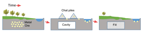
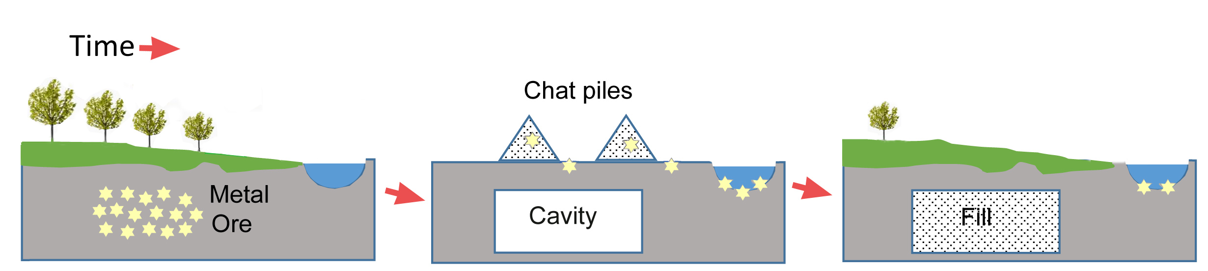
2.1. Some History of the TSMD Mining and Remediation

The lead-zinc mineralization in the TSMD is of Mississippi Valley-Type [7]. The ore consisted of sphalerite (ZnS), galena (PbS), and a small amount of chalcopyrite (CuFeS2). The ore was associated with chert and jasper and was hosted in sedimentary rocks of Mississippian age [7]. In the late 1800s, ore was mined from shallow deposits. With time, richer and deeper deposits were found in the western part of the TSMD, which required underground mining and large-scale smelters near the mining centers. Towns of the TSMD spread over a large area, reflecting the dispersed pattern of the ore emplacement [8,23]. Waste rock (chat) was piled near the entrance of the mines and most piles remained in place after mining companies moved out. A smelter operated within the city of Joplin [13,20,21]. Specialized reports about the geology of ore deposits, mineralogy, surface hydrology, and mining history of the TSMD are available elsewhere [7,8,9,12,13,23,24,25,26].
Remediation actions within the TSMD were subdivided by the type of action needed (each known as an operational unit) [20]. Priority was given to areas posing a major health threat to the human inhabitants (e.g., replacing contaminated soils in areas frequented by children), in accordance to available funds. Mine waste (chat) was used to fill cavities, as gravel for road construction, to improve traction in snow covered roads, and as aggregate [11,12]. Although chat is still used as fill material, it is now capped to minimize exposure to soil and water [11,20]. Remediation actions continue to be ongoing on all four TSMD Superfund sites.
In the Oronogo-Duenweg Superfund site, over 90% of mined land had been remediated by 2017 [27]; from the 150 million tons of waste produced by the hundreds of mines and prospects operating in Jasper County, only 10 million tons (6.7%) remained [27]. Remedial actions within the Oronogo-Duenweg Superfund site are described in detail in four five-years reports (2002 to 2017) [20]. Remediation success is determined by the reduction of the disturbance; e.g., reduced extent of the historical chat piles [20,27] shown in Figure 2. In this site and other remediated areas, sights of former mining activities are now rare, and wildlife is gradually returning to the area [16].
The numerous cavities, such as mine shafts and tunnels from room-and-pillar underground mining, presented a challenge to remediation by phytostabilization in this area. Smaller mine cavities such as Sucker Flats, near Joplin, were filled up with chat and transformed into a park without a problem, but filling larger cavities was more difficult. For example, the Oronogo Circle could not be filled even after the dumping of 1.5 million m3 of chat and other mining waste in it, because of long, deep tunnels at its bottom. A related threat consisted of surface water seeping through mining shafts and large fractures in the limestone that could carry metals into the aquifer [28]. In places where mine cavities are filled up and the water is slowed down by soil and vegetation cover, the groundwater contamination threat is lessened. Notwithstanding the lesser threat, measures were taken to protect the aquifer. In Jasper and Newton Counties, where intensive mining occurred, a wellhead protection program was implemented [20,29,30].
Remediation actions comprised in the redevelopment initiative program [21] aimed to promote a steadfast transition to a sustainable land use. Solutions applied to the disposal of mine waste vary in type and extent. These include a constructed wetland that removes Zn from wastewater at Center Creek treatment plant and a composting facility that incorporates contaminated soil and various organic wastes (manure, wood chips) to produce topsoil. In the land remediated by phytostabilization, native vegetation grew, which helped restore the ecological niches to pre-mining conditions [6,16,31]. Structures built on this land include a metal recycling center and 5 km (3 miles) of new roads [21]. In these building projects, chat used as aggregate was contained and capped.

2.2. Sampling and Geochemical Methods

The study focuses on two small streams, Turkey Creek and Center Creek, both designated as impaired streams [32,33]. The studied stream segments are encompassed within the Oronogo-Duenweg Superfund Site, Missouri.
The distribution and extent of former chat piles was approximated by the areal coverage of mines, using maps available in GeoStrat (Missouri Department of Natural Resources), and backed up by available old maps and aerial photographs. Then, Google Earth and field truthing were used to verify the presence of the remaining chat piles in 2019. This information was relevant to account for the metal content in stream sediments.
Stream sediments samples were collected from Turkey Creek on two sampling events, in November 2017 (19 samples) and March 2018 (11 samples). Once the first 19 samples showed high variability in metal content and no downstream pattern, additional samples were collected in Turkey Creek to verify the findings. Samples were collected from Central Creek on March 2019 (14 samples). Samples spread within a 10 km segment of each creek where there was easy access (e.g., near a bridge). At each sampling location, about 0.5 kg of sediment was placed in a sealed plastic bag and maintained cool during its transport to the laboratory, where they were spread over wax paper and air dried. Once dry, the samples were disaggregated using mortar and pestle and sieved to 1 mm size. A subsample was sent to the commercial lab ALS Global for analysis of pseudo-total metal content using ICP-MS-spectrophotometry. The term “pseudo-total” differentiates the extraction using aqua regia from the extraction using the stronger acid solution HF-HClO4 [34]. Aqua regia is considered adequate for extracting sulfate and sulfide minerals, and for this reason this solvent used widely in sediment studies.
A second subsample was used for obtaining the potentially bioavailable fraction and analyzed in house (MSU). To this purpose, 40 mL 0.11 M acetic acid solution were added to 1.00 g of dry sediment. The suspension was shaken intermittently for 12 h, after which it was centrifuged in an IEC Model K Centrifuge (International Equipment Co., Needham Heights, MA, USA), and the supernatant analyzed for metal content using an ICP-MS spectrometer (Agilent Technologies 7900 ICP-MS, Santa Clara, CA, USA). This metal represented the loosely attached fraction of metal that stores in the exchangeable fraction; therefore, it is considered the potentially bioavailable fraction.
Quality control included field duplicates, lab replicates, and blanks. A field duplicate consisted of two samples collected within 1–2 m from each other. A total of four pairs (field duplicates) were collected. Lab replicates consisted of running an analysis of the same sample, and were ran every 10 samples. Concentrations of replicates were within acceptable limits (<5%) on all metals, whereas field duplicates showed high variability (1% to 60% difference in Zn content and 2–11% difference in Pb content). Two blanks were prepared by omitting the sediment sample to vials that went through extraction and centrifugation procedures. Blanks did not show metal in measurable amounts.
Toxicity of the sediments was determined after comparing total metal concentration values with PEC-Q (probable effect concentration quotient) guidelines reported for Ozarks’ streams [35]. Toxicity and PEC-Q are described below.

2.3. Sediment Toxicity

Besides Pb and Zn, cadmium (Cd), a highly toxic metal associated with Zn, has been reported in the TSMD sediments [7,8,9]. Under oxic conditions, heavy metals remain relatively immobile for long intervals of time [36] and only a small fraction remobilizes. The remobilized fraction becomes available to aquatic biota (bioavailable fraction). Mobility has been reported as Cd > Zn > Pb for TSMD [8]. The metals that remobilize (e.g., during flood events) would travel further downstream, to be trapped in the sediments of a reservoir [18,26,37] or in the floodplain [38,39].
Numerous studies have addressed the toxicity of metals to aquatic organisms [35,40] and wildlife [41]. A useful guideline to determine the toxicity risk in TSMD sediments, the sum probable effect quotient (∑PEC-QCd,Pb,Zn) based on Cd, Pb, and Zn concentrations (in mg/kg), is shown below [35]. This equation was obtained after recording the biological response of a variety of benthic organisms, including the freshwater amphipod Hyalella azteca, and the fat mucket, Lampsilis siliquoidea, to the above metals. The risk to benthic invertebrates in a specific region is obtained after comparing the result the sum probable effect quotient to a threshold value, which is 10.04 mg/kg for the TSMD area [35]. That is, values < 10.04 mg/kg indicate little to no toxicity risk to benthic invertebrates, whereas values > 10.04 mg/kg indicate a high risk.
  PEC Q Cd , Pb , Zn =   Cd 4.98 +   Pb 128 +   Zn 459
The potentially bioavailable fraction, a parameter associated with toxicity risk, was determined by extracting metals from sediment using a 0.11 acetic acid solution [42,43].

2.4. Statistical Tests

A two-tailed T-test of two samples assuming equal variances using Excel was applied to each Cd, Pb, Zn and ∑PEC-QCd,Pb,Zn to determine if there was a significant difference between the values obtained for Center Creek and those of Turkey Creek. The same T-test was applied to the bioavailable fraction, using a subset of the samples (19 samples of Turkey Creek and 11 of Center Creek) to which samples of background (total) concentration were removed.

3. Results

Figure 3 shows the location of the historic mines around the city of Joplin (orange symbols). The area covered by these mines corresponds roughly to the extent of land covered with chat piles, since chat was piled by the entrances of mines. The chat piles that remained in 2019 are shown as red polygons in Figure 3. A visual appraisal of the land covered by the remaining chat piles compared to the extent of the historic mines concurs with the reported value of 6% mining waste remaining in the area [27]. Besides showing the location of the remaining chat piles and the extent of remediation, Figure 3 makes evident the scattered pattern of both historical and remaining chat piles. Also noticeable are the multiple sources of contamination that could contribute metals via runoff to either Turkey Creek or Center Creek.
The metal content of Turkey and Center creek sediments are listed in Table 1 and complete data set and calculations are included in the Supplement Material File S1. The total metal concentrations are all higher than the reported background levels for TSMD sediments of 0.5 mg/kg Cd, 28 mg/kg Pb and 105 mg/kg Zn [17]. Median metal concentrations in Turkey Creek (N = 30 samples) were 10.8 mg/kg Cd, 160 mg/kg Pb, and 2350 mg/kg Zn, which correspond to 20, 6, and 22 times the background concentration, respectively. Similarly, the median concentrations of Center Creek sediments (N = 14) were 26.2 mg/kg Cd, 521 mg/kg Pb, and 5425 mg/kg Zn, which correspond to 52, 19, and 52 times the background concentration, respectively.
A T-test among metal concentrations of the two streams showed that Zn values between Turkey and Center creeks were no different (t = 0.99 significant at 0.05, two tailed). Cd values were also not different (t = 0.40 significant at 0.05, two tailed) a result that was expected due to the close association between Zn and Cd in the ore [7]. Conversely, the T-test showed a significant difference in the Pb content between Turkey and Center Creeks (t = 0.04), which may reflect the immobile nature of Pb, which prevents Pb from distributing throughout the sediment, preserving the high and low concentrations near each other. Similar behavior of Pb has been reported by other studies within the TSMD [10,17,18,19]. Compared to Center Creek, Turkey Creek sediments had larger standard deviation values, meaning that the metal content varied over a wider range of concentrations. The high variability in total metal content that is shown in both streams, as well as in field duplicates, is likely a result of the heterogeneous distribution of waste piles and the subsequent sediment disturbances resulting from remedial actions conducted in the area over recent years.
Table 2 lists the percent potential bioavailability obtained from the 0.11 M acetic acid extraction procedure. The potential bioavailability values are relatively low, ranging between 0.36% and 4.96% of the total metal content, indicating the preference of metals to remain attached to the solid fraction. Turkey Creek shows a slightly higher percentage of potentially bioavailable metal content than Center Creek, based on median values. A t-test for comparing the bioavailable fraction between the two creeks resulted in differences being significant for Cd (t = 0.020 significant at 0.05, two tailed) and Zn (t = 0.020) but not significant for Pb (t = 0.57). The results show a mobility Zn > Cd > Pb, in disagreement to previous studies reporting Cd as the metal with higher mobility [8].
Toxicity risk posed by the above metals (∑PEC-QCd,Pb,Zn) to benthic invertebrates in TSMD streams is reported here following the accepted format [35] as the percent of samples having high toxicity. A comparison of metal concentrations and ∑PEC-Q guideline returned a high toxicity risk for 40% of Turkey Creek samples (12 of 30) and 79% of Center Creek samples (11 of 14).

4. Discussion

Figure 1 shows Turkey and Center creeks flowing by an abundance of historic chat piles, which provided multiple points of metal input (Figure 2). With time, the chat piles were reduced in size and number, but a few remain and they continue to contribute metals to both creeks. The sediments of both creeks showed high variability in metal concentrations and lacked a specific downstream concentration pattern, as seen in Figure 3. This lack of pattern may be explained by the dispersed location of the former tailing piles, the different mobility of the three metals, and the physical disruption of chat and sediments during remediation actions over the past few decades. The disruption to sediments mentioned above consists of deposition of sediments resulting from leveling of land and application of new soil material, as dredging of stream sediments was not a part of the remediation action plan [21]. High variabilities in metal content in other streams within the TSMD have also been reported [10,17,18,19].
Both Center Creek and Turkey Creek are considered major sources of metal pollution to the Spring River [18,32,33]. The Spring River is impounded in Kansas, forming Empire Lake, after which it flows into Oklahoma’s Grand Lake O’ the Cherokees, a large reservoir built on the Big River, where high levels of lead in fish have been observed [33]. Empire Lake is considered a major storage body for metal contaminated sediments [26]. Cd, Pb, and Zn median concentrations in sediments of Empire Lake are 29 mg/kg, 270 mg/kg, and 4900 mg/kg, respectively. Sediment samples in the Spring River directly below Empire Lake also had high metal content, attributed to the outflow of sediments from Empire Lake during high-inflow periods [26].
In theory, the input of metals to the streams should decline with time in remediated areas [19]. This pattern is not yet evident at the TSMD. For example, the town Aurora in the eastern part of the TSMD produced less ore compared to Joplin and remediation of the area has been complete for over 10 years. In Aurora, the contamination of stream sediments is restricted to a short segment of the receiving stream [17], but some of the characteristics of TSMD streams remain, such as the variability and high metal content. Similarly, sediments re-sampled after a 13-year interval in the TSMD Cherokee County Superfund site (Kansas), showed metal concentrations increasing in some sites and decreasing in others [19].
Table 3 lists the metal content in sediments of Turkey Creek and Center Creek reported by selected studies [18,43,44]. No trend in values is observed with time, which suggest that more time (a few decades) is needed for a decreasing trend to become evident.
The alkaline conditions in streams flowing over limestone rock promote the precipitation and adsorption of metals (e.g., metals adsorbing to iron oxyhydroxides). Weathering of sulfide minerals under alkaline conditions form secondary minerals, many of which are insoluble, such as cerussite (PbCO3) and smithsonite (ZnCO3) [9,10]. Heavy metals are therefore confined to the solid phase for the most part.
Our values of toxicity (40% samples of high toxicity for Turkey Creek and 79% for Center Creek) differ somewhat from those reported [35] of 83% and 46% for Turkey Creek and Center Creek, respectively. However, considering the high variability in metal content and the difference in length and location of the studied stream segments, the results can be considered as being similar in nature.

Threats by Metal Resuspension and Dissolution

Limestone, the carbonate rock hosting the Zn, and Pb ore, is the major outcropping lithology in the region [7]. Limestone dissolution creates a natural buffer to acidity that reduces the solubility of metals. On the other hand, the solid surfaces present in stream sediments such as clay and organic matter, have a tendency to strongly adsorb metals, especially Zn and Pb [10]. As a result of both processes, the metals concentrate in the solid phase and the health risk to the human population is thus reduced. However, throughout the years waste has been exposed, large amounts of these metals have accumulated in the sediments of streams, downstream reservoirs, and lakes [18,26,38] and they may move back to the water column during either high water inflows [37] or lowering of Eh and/or pH values.
Limestone in the TSMD area is highly fractured [7,8]. In the case of deep mines, water pumps ran continuously to allow mining operations. Once mining operations ceased and pumps stopped, water filled the cavities, and water became in contact with the iron sulfides present in sulfide ores to form acid mine drainage [10,23]. Acidity helps remobilize metals and remobilized metal flowing through fractures into the aquifer poses a threat to groundwater. As a precaution, casing the wells in Jasper and Newton counties, Missouri, aim to prevent a possible path of toxic lead and cadmium through this fractured ground [29,30].

5. Conclusions

Sediments of Center Creek and Turkey Creek, two streams crossing the area where multiple chat piles once stood, were sampled in 2018–2019 to determine their metal contamination, potential bioavailability, and toxicity. The results showed Pb, Zn, and Cd concentrations varying over a wide range of values, there was no downstream concentration pattern, and many of the samples containing metals in concentrations were high enough to be toxic to aquatic biota. Remaining chat piles and stream locations with highest metal concentration were identified and mapped.
Potential bioavailability of Cd, Pb, and Zn varied between 0.36% and 4.96% of the total metal content. The relatively low values obtained attest to the preference of metals to attach to the solid phases. The highest potential bioavailability was obtained for Zn and Cd and the lowest for Pb.
A reduction of metal contamination in water, soils, and sediments to non-toxic levels was expected as a result of remediation being almost complete in the area. Instead, toxic levels were present in both Center and Turkey Creek sediments. This result suggests that the mobilization of metals is a slow process, and not enough time has elapsed since remediation started for a declining trend to become evident.

Supplementary Materials

The following are available online at https://www.mdpi.com/2075-163X/10/3/247/s1, File S1: DataTurkeyCreek_CenterCreek.

Author Contributions

Conceptualization, M.G.; methodology, M.G.; software, X.Q.; validation, X.Q. and Z.J.C.; formal analysis, M.G., X.Q. and Z.T.L.; investigation, M.G. and Z.J.C.; resources, Z.J.C.; data curation, Z.T.L. and X.Q.; writing—original draft preparation, M.G.; writing—review and editing, M.G. and X.Q.; visualization, M.G.; supervision, M.G.; project administration, M.G.; funding acquisition, M.G. and Z.J.C. All authors have read and agreed to the published version of the manuscript.

Funding

This research received no external funding.

Acknowledgments

The authors acknowledge the NSF 1828069 CHE grant Acquisition of an Inductively-Coupled Plasma Mass Spectrometer (ICP-MS) System awarded to Missouri State University (MSU) and a thesis grant awarded to Zachary J. Collette by the MSU Graduate College that helped defray costs of metal analyses and sample collection.

Conflicts of Interest

The authors declare no conflict of interest.

References

  1. Gutiérrez, M.; Mickus, K.; Camacho, L.M. Abandoned Pb–Zn mining wastes and their mobility as proxy to toxicity: A review. Sci. Total Environ. 2016, 565, 392–400. [Google Scholar] [CrossRef] [PubMed]
  2. Kivinen, S. Sustainable post-mining land use: Are closed metal mines abandoned or re-used space? Sustainability 2017, 9, 1705. [Google Scholar] [CrossRef] [Green Version]
  3. Alghamdi, A.; Kirkham, M.B.; Presley, D.R.; Hettiarachchi, G.; Murray, L. Mine site rehabilitation with biosolids, In Spoil to Soil: Mine Site Rehabilitation and Revegetation; Bolan, N.S., Kirkham, M.B., Eds.; CRC Press: New York, NY, USA, 2017; pp. 241–258. [Google Scholar]
  4. Bolan, N.S.; Park, J.H.; Robinson, B.; Naidu, R.; Huh, K.Y. Phytostabilization: A green approach to contaminant containment. Adv. Agron. 2011, 112, 145–204. [Google Scholar]
  5. Mborah, C.; Bansah, K.J.; Mark, K.; Boateng, M.K. Evaluating alternate post-mining land-uses: A review. Environ. Pollut. 2016, 5, 1. [Google Scholar] [CrossRef] [Green Version]
  6. Abandoned Mine Lands: Revitalization and Reuse, USEPA. Available online: www.epa.gov/superfund/abandoned-mine-lands-revitalization-and-reuse (accessed on 15 February 2020).
  7. Brockie, D.C.; Hare, E.H.; Dingess, P.R. The geology of ore deposits of the Tri-State Mining District of Missouri, Kansas and Oklahoma. In Ore Deposits of the United States, 1933–1967, I.; Ridge, J.D., Ed.; The American Institute of Mining, Metallurgical, and Petroleum Engineers: Englewood, CO, USA, 1968; pp. 400–430. [Google Scholar]
  8. Johnson, A.; Gutiérrez, M.; Gouzie, D.; McAlily, R. State of remediation and metal toxicity in the Tri-State Mining District, USA. Chemosphere 2016, 144, 1132–1141. [Google Scholar] [CrossRef] [PubMed]
  9. Carroll, S.A.; O’Day, P.A.; Piechowski, M. Rock-water interactions controlling zinc, cadmium, and lead concentrations in surface waters and sediments, U.S. Tri-State Mining District. 2. Geochemical Interpretation. Environ. Sci. Technol. 1998, 32, 956–965. [Google Scholar] [CrossRef]
  10. Schaider, L.A.; Senn, D.B.; Brabander, D.J.; McCarthy, K.D.; Shine, J.P. Characterization of zinc, lead, and cadmium in mine waste—Implications for transport, exposure, and bioavailability. Environ. Sci. Technol. 2007, 41, 4164–4171. [Google Scholar] [CrossRef] [PubMed]
  11. Kirkwood, N.G. CHAT: Approaches to long-term planning for the Tar Creek Superfund site, Ottawa County, Oklahoma. In Reclaiming the Land. Rethinking Superfund Institutions, Methods and Practices; Macey, G.P., Cannon, J.Z., Eds.; Springer Science and Business Media: New York, NY, USA, 2007; pp. 267–292. [Google Scholar]
  12. Smith, S.J. Estimation of volume and mass and of changes in volume and mass of selected chat piles in the Picher Mining District, Ottawa County, Oklahoma, 2005–2010. In U.S. Geological Survey Scientific Investigations Report 2013–5011; U.S. Geological Survey: Reston, VA, USA, 2013; pp. 1–20. Available online: http://pubs.usgs.gov/sir/2013/5011/ (accessed on 8 March 2020).
  13. ITRC, Interstate Technology & Regulatory Council. Tri-State Mining District (Kansas, Oklahoma, Missouri). In Remediation Management of Complex Sites; RMCS-1: Washington, DC, USA, 2017; p. 15. Available online: http://rmcs-1.itcweb.org (accessed on 7 February 2020).
  14. Juracek, K.E.; Drake, K.D. Mining-related sediment and soil contamination in a large Superfund site: Characterization, habitat implications, and remediation. Environ. Manage. 2016, 58, 721. [Google Scholar] [CrossRef] [PubMed]
  15. Andrews, W.J.; Becker, M.F.; Mashburn, S.L.; Smith, S.J. Selected metals in sediments and streams in the Oklahoma Part of the Tri-State Mining District, 2000–2006. In U.S. Geological Survey Scientific Investigations Report 2009–5-032; U.S. Geological Survey: Reston, VA, USA, 2009; pp. 1–36. [Google Scholar]
  16. Brown, S.; Mahoney, M.; Sprenger, M.A. A comparison of the efficacy and ecosystem impact of residual-based and topsoil-based amendments for restoring historic mine tailings in the Tri-State Mining District. Sci. Total Environ. 2014, 485–486, 624–632. [Google Scholar] [CrossRef] [PubMed]
  17. Gutiérrez, M.; Wu, S.; Rodriguez, J.; Jones, A.D.; Lockwood, B. Assessing the state of contamination for a historic mining town using sediment chemistry. Arch. Environ. Contam. Toxicol. 2016, 70, 747–756. [Google Scholar] [CrossRef] [PubMed]
  18. Smith, D.C. Occurrence, distribution, and volume of metals-contaminated sediment of selected streams draining the Tri-State Mining District, Missouri, Oklahoma, and Kansas. In U.S. Geologic Survey Scientific Investigations Report 2013-5011; U.S. Geological Survey: Reston, VA, USA, 2016; pp. 1–20. Available online: http://pubs.usgs.gov/sir/2013/5011/ (accessed on 8 March 2020).
  19. Klager, B.J.; Juracek, K.E. Evaluation of streambed-sediment metals concentrations in the Spring River Basin, Cherokee County Superfund Site, Kansas, 2017. In U.S. Geological Survey Scientific Investigations Report 2019–5046; U.S. Geological Survey: Reston, VA, USA, 2019; pp. 1–25. [Google Scholar] [CrossRef]
  20. ITRC (Interstate Technology & Regulatory Council). Oronogo-Duenweg Mining Site, Jasper County, Missouri. Mine Waste Treatment Technology Selection Web. Interstate Technology & Regulatory Council, Mining Waste Team: Washington, DC, USA, 2010. Available online: www.itrcweb.org (accessed on 7 February 2020).
  21. Superfund Site: Oronogo-Duenweg Mining Belt, Joplin, MO, Site Documents & Data, USEPA. Available online: https://cumulis.epa.gov/supercpad/SiteProfiles/index.cfm?fuseaction=second.docdata&id=0701290 (accessed on 7 February 2020).
  22. Superfund Redevelopment Initiative, USEPA. Available online: www.epa.gov/superfund-redevelopment-initiative (accessed on 7 February 2020).
  23. Brosius, L.; Sawin, R.S. Lead and Zinc Mining in Kansas; Kansas Geological Survey Public Information Circular: Lawrence, KS, USA, 2001; vol. 17, p. 6. Available online: http://www.kgs.ku.edu/Publications/pic17/pic17_1.html (accessed on 7 February 2020).
  24. DeHay, K.L.; Andrews, W.J.; Sughru, M.P. Hydrology and ground-water quality in the mine workings within the Picher Mining District, Northeastern Oklahoma, 2002–2003. In USGS Scientific Investigations Report 2004-5043; U.S. Geological Survey: Reston, VA, USA, 2004; pp. 1–62. [Google Scholar]
  25. Pope, L.M. Assessment of contaminated streambed sediment in the Kansas part of the historic Tri-State lead and zinc mining district, Cherokee County, 2004. In U.S. Geological Survey Scientific Investigations Report 2005-5251; U.S. Geological Survey: Reston, VA, USA, 2005; pp. 1–61. [Google Scholar]
  26. Juracek, K.E. Sedimentation and occurrence and trends of selected chemical constituents in bottom sediment, Empire Lake, Cherokee County, Kansas, 1905–2005. In U.S. Geological Survey Scientific Investigations Report 2006–5307; U.S. Geological Survey: Reston, VA, USA, 2006; pp. 1–79. [Google Scholar]
  27. Fourth five-year report for Oronogo-Duenweg Mining Belt Superfund Site Jasper County, Missouri, USEPA. Available online: https://semspub.epa.gov/work/07/30323583.pdf (accessed on 10 February 2020).
  28. Pope, L.M.; Mehl, H.E.; Coiner, R.L. Quality characteristics of ground water in the Ozark aquifer of northwestern Arkansas, southeastern Kansas, southwestern Missouri, and northeastern Oklahoma, 2006–2007. In U.S. Geological Survey Scientific Investigations Report 2009–5093; U.S. Geological Survey: Reston, VA, USA, 2009; pp. 1–60. [Google Scholar]
  29. Wells and Drilling. Missouri Department of Natural Resources. Available online: https://dnr.mo.gov/geology/geosrv/wellhd/wellsanddrilling.htm (accessed on 10 February 2020).
  30. Newton/Jasper County Special Area Casing Depth Map, Missouri Department of Natural Resources, Wells Wellhead Protection Program. Available online: https://dnr.mo.gov/geology/geosrv/wellhd/ (accessed on 10 February 2020).
  31. Doley, D.; Audet, P. Identifying natural and novel ecosystem goals for rehabilitation of postmining landscapes. In Responsible Mining: Case Studies in Managing Social & Environmental Risks in the Developed World; Jarvie-Eggart, M.F., Ed.; Society for Mining, Metallurgy & Exploration Inc.: Englewood, CO, USA, 2015; pp. 609–638. [Google Scholar]
  32. Total Maximum Daily Load Information Sheet. Turkey Creek, Missouri Department of Natural Resources; Revised 2/2015. Available online: https://dnr.mo.gov/env/wpp/tmdl/info/docs/3216-3217-turkey-ck-info.pdf (accessed on 10 February 2020).
  33. Total Maximum Daily Load Information Sheet. Center Creek, Missouri Department of Natural Resources; Revised 1/2011. Available online: https://dnr.mo.gov/env/wpp/tmdl/info/docs/3203-center-ck-info.pdf (accessed on 10 February 2020).
  34. Ščančar, J.; Milačič, R.; Horvat, M. Comparison of various digestion and extraction procedures in analysis of heavy metals in sediments. Water Air Soil Pollut. 2000, 118, 87–99. [Google Scholar] [CrossRef]
  35. MacDonald, D.D.; Smorong, D.E.; Ingersoll, C.G.; Besser, J.M.; Brumbaugh, W.G.; Kemble, N.; May, T.W.; Ivey, C.D.; Irving, S.; O’Hare, M. Development and Evaluation of Sediment and Pore-Water Toxicity Thresholds to Support Sediment Quality Assessments in the Tri-State Mining District (TSMD), Missouri, Oklahoma, and Kansas. In Final Technical Report to U.S. Environmental Protection Agency, Dallas TX and Kansas City KS, and U.S. Fish and Wildlife Service; MacDonald Environmental Sciences, LTD: Nainamo, British Columbia, CA, USA, 2009. Available online: https://archive.epa.gov/region07/cleanup/npl-archive/web/pdf/000030284900.pdf (accessed on 7 February 2020).
  36. Salomons, W.; Förstner, U. Metals in the Hydrocycle; Springer: Berlin, Germany, 1984; p. 333. [Google Scholar]
  37. Ciszewski, D.; Grygar, T.M. A review of flood-related storage and remobilization of heavy metal pollutants in river systems. Water Air Soil Pollut. 2016, 227, 239. [Google Scholar] [CrossRef] [PubMed] [Green Version]
  38. Garvin, E.M.; Bridge, C.F.; Garvin, M.S. Screening level assessment of metal concentrations in streambed sediments and floodplain soils within the Grand Lake watershed in northeastern Oklahoma, USA. Arch. Environ. Contam. Toxicol. 2017, 72, 349–363. [Google Scholar] [CrossRef] [PubMed]
  39. Juracek, K.E. Occurrence and variability of mining-related lead and zinc in the Spring River flood plain and tributary flood plains, Cherokee County, Kansas, 2009–2011. In U.S. Geological Survey Scientific Investigations Report 2013–5028; U.S. Geological Survey: Reston, VA, USA, 2013; p. 70. [Google Scholar]
  40. Besser, J.M.; Brumbaugh, W.G.; Ingersoll, C.G. Characterizing toxicity of metal-contaminated sediments from mining areas. Appl. Geochem. 2015, 57, 73–84. [Google Scholar] [CrossRef]
  41. Beyer, W.N.; Dalgarn, J.; Dudding, S.; French, J.B.; Mateo, R.; Miesner, J.; Sileo, L.; Spann, J. Zinc and lead poisoning in wild birds in the Tri-State Mining District (Oklahoma, Kansas, and Missouri). Arch. Environ. Contam. Toxicol. 2004, 48, 108–117. [Google Scholar] [CrossRef] [PubMed]
  42. Rauret, G.; López-Sánchez, J.F.; Sahuquillo, A.; Rubio, R.; Davidson, C.; Ureb, A.; Quevauvillerc, P. Improvement of the BCR three step sequential extraction procedure prior to the certification of new sediment and soil reference materials. J. Environ. Monit. 1999, 1, 57–61. [Google Scholar] [CrossRef] [PubMed]
  43. Gutiérrez, M.; Collette, Z.J.; McClanahan, A.M.; Mickus, K. Mobility of metals in sediments contaminated with historical mining wastes: Example from the Tri-State Mining District, USA. Soil Syst. 2019, 3, 22. [Google Scholar] [CrossRef] [Green Version]
  44. Allert, A.L.; Wildhaber, M.L.; Schmitt, C.J.; Chapman, D.; Callahan, E. Toxicity of sediments and pore-waters and their potential impact on Naosho Madtom Noturus placidus, in the Spring River System affected by historic zinc-lead mining and related activities in Jasper and newton Counties, Missouri; and Cherokee County, Kansas. In Final Report to the U.S. and Wildlife Service; US Geological Survey, Biological Resources Division: Columbia, MO, USA, 1997. [Google Scholar]
  45. Van Geel, A.; Bosch, T.; Clark, H.; Donlan, M. Damage Assessment Plan for Jasper and Newton Counties, Missouri. In Report to Missouri Department of Natural Resources by Industrial Economics, Inc.; Industrial Economics Inc.: Cambridge, MA, USA, 2009; pp. 1–117. [Google Scholar]
Figure 1. Study area showing the historic mine locations around the city of Joplin, the area affected by smelter fallout, and the location of Turkey Creek and Center Creek.
Minerals 10 00247 g001
Figure 2. Extent of historic chat piles in the Oronogo-Duenweg Superfund site and smelter zone. The area of this study is shown shaded. Modified from the U.S. Environmental Protection Agency (USEPA) [27].
Minerals 10 00247 g002
Figure 3. Location and areal coverage of remaining chat piles (as of 2019) and metal toxicity in stream sediments (∑PEC-QCd,Pb,Zn) based on Cd, Zn, and Pb concentrations. Both Turkey Creek and Center creek are flowing northwest towards the Spring River.
Minerals 10 00247 g003
Table 1. Metal concentration in sediments (in mg/kg) from Turkey Creek and Center Creek, Missouri. Samples were collected in 2018–2019, and are listed in downstream order.
SampleTurkey CreekCenter Creek
CdPbZn∑PEC-QCdPbZn∑PEC-Q
112.027414807.854.3595993037.2
27.921212105.937.2596948032.8
36.234610506.216.71010700026.5
420.9471286014.16.4898481018.8
565.51870718043.43.9854362.4
620.51000413020.94.0884412.5
76.3715853.13.8764262.3
853.6590728031.277.4420679033.6
911.212718307.250.7469581026.5
108.6642712.816.7481233012.2
114.4514622.317.8464251012.7
125.71288544.042.5726603027.3
1310.114414606.334.5573514022.6
1419.3291242011.453.7561836033.4
1512.116317107.4
1617.5453507018.1
1710.8176357011.3
184.31229423.9
199.513122807.9
203.71109023.6
214.51159153.8
2221.3161695020.7
2310.214624908.6
2412.9185328011.2
2510.615919207.6
26113.519237,100105.1
2710.211827108.9
2810.814227009.2
29127.022635,800105.3
3035.4152819026.1
Median10.81602,3508.326.2521542524.5
Std.Dev.±30.1±356±8,826±25.1±23.5±281±3287±12.0
Table 2. Potentially bioavailable fraction (in %) of Center Creek and Turkey Creek sediment samples.
Turkey Creek (N = 19)Center Creek (N = 11)
Median (Std.Dev.)Median (Std.Dev.)
Cd1.59% (4.3)0.70% (1.3)
Pb0.39% (0.4)0.36% (0.2)
Zn4.96% (4.7)1.95% (1.1)
Table 3. Average (or range of values) of metal concentrations in stream sediments (depth 0–1 ft) reported for Turkey Creek and Center Creek, Missouri. N = No. of samples.
19951981–20072011–20122017–2019
Turkey Creek
Pb, mg/kg69.5–138289485280
Zn, mg/kg659–1490479595754987
Cd, mg/kgn/a18.865.322.2
Center Creek
Pb, mg/kg301–2120279346503
Zn, mg/kg2060–13,800288145454964
Cd, mg/kgn/a21.728.130.0
Reference study[44], N = 4[45], N = 31[18], N = 6This study, N = 44

