
Potential for Agricultural Expansion in Degraded Pasture Lands in Brazil Based on Geospatial Databases

 , ,
, ,  ,
,
Abstract
:1. Introduction
2. Materials and Methods
3. Results
4. Discussion
5. Conclusions
Author Contributions
Funding
Data Availability Statement
Conflicts of Interest
References
- Organisation for Economic Co-Operation and Development (OECD); Food and Agriculture Organization of the United Nations (FAO). Agricultural Outlook 2023–2032; OECD Publishing: Paris, France, 2023. [Google Scholar] [CrossRef]
- Bolfe, É.L.; Jorge, L.A.C.; Sanches, I.D.; Luchiari Júnior, A.; Costa, C.C.; Victoria, D.C.; Inamasu, R.Y.; Grego, C.R.; Ferreira, V.R.; Ramirez, A.R. Precision and digital agriculture: Adoption of technologies and perception of Brazilian farmers. Agriculture 2020, 10, 653. [Google Scholar] [CrossRef]
- MapBiomas. Mapeamento Anual do Uso e Cobertura da Terra no Brasil. Mapas de Uso e Cobertura da Terra. 2022. Available online: https://brasil.mapbiomas.org/produtos/ (accessed on 14 October 2023).
- Souza, C.M., Jr.; Shimbo, J.Z.; Rosa, M.R.; Parente, L.L.; Alencar, A.A.; Rudorff, B.F.T.; Hasenack, H.; Matsumoto, M.; Ferreira, L.G.; Souza-Filho, P.W.M.; et al. Reconstructing three decades of land use and land cover changes in Brazilian biomes with Landsat archive and Earth Engine. Remote Sens. 2020, 12, 2735. [Google Scholar] [CrossRef]
- Ministério da Agricultura, Pecuária e Abastecimento (Brasil). Projeções do Agronegócio 2022/2023 a 2032/2033. 2023. Available online: https://www.gov.br/agricultura/pt-br/assuntos/politica-agricola/todas-publicacoes-de-politica-agricola/projecoes-do-agronegocio (accessed on 10 November 2023).
- Phelps, L.N.; Kaplan, J.O. Land use for animal production in global change studies: Defining and characterizing a framework. Glob. Chang. Biol. 2017, 23, 4457–4471. [Google Scholar] [CrossRef] [PubMed]
- Food and Agriculture Organization—Food and Agriculture Statistics (FAOSTAT). Glossary List. 2014. Available online: http://faostat.fao.org/site/375/default.aspx (accessed on 28 January 2024).
- Universidade Federal de Goiás (UFG); Laboratório de Processamento de Imagens e Geoprocessamento (LAPIG). Atlas das Pastagens. 2022. Available online: https://atlasdaspastagens.ufg.br/map (accessed on 10 October 2023).
- Boddey, R.M.; Casagrande, D.R.; Homem, B.G.C.; Alves, B.J.R. Forage legumes in grass pastures in tropical Brazil and likely impacts on greenhouse gas emissions: A review. Grass Forage Sci. 2020, 75, 357–371. [Google Scholar] [CrossRef]
- Molossi, L.; Hoshide, A.K.; Abreu, D.C.; Oliveira, R.A. Agricultural support and public policies improving sustainability in Brazil’s beef industry. Sustainability 2023, 15, 4801. [Google Scholar] [CrossRef]
- Telles, T.S.; Bacchi, M.D.; Costa, G.V.; Schuntzemberger, A.M.S. Milk production systems in southern Brazil. An. Acad. Bras. Cienc. 2020, 92, e20180852. [Google Scholar] [CrossRef] [PubMed]
- Cândido, M.J.D.; Araújo, G.G.L.; Cavalcante, M.A.B. Pastagens no ecossistema semi-árido brasileiro: Atualização e perspectivas futuras. Rev. Soc. Bras. Zootec. 2005, 42, 85–94. [Google Scholar]
- Mueller, C.C.; Martha, G.B., Jr. A agropecuária e o desenvolvimento sócio-econômico recente do Cerrado. In Simpósio Nacional de Cerrado; Simpósio Internacional de Savanas Tropicais: Embrapa Cerrados, Brasília, 2008; Volume 9. [Google Scholar]
- Sloat, L.L.; Gerber, J.S.; Samberg, L.H.; Smith, W.K.; Herrero, M.; Ferreira, L.G.; Godde, C.M.; West, P.C. Increasing importance of precipitation variability on global livestock grazing lands. Nat. Clim. Chang. 2018, 8, 214–218. [Google Scholar] [CrossRef]
- Aguiar, D.A.; Mello, M.P.; Nogueira, S.F.; Gonçalves, F.G.; Adami, M.; Rudorff, B.F.T. MODIS time series to detect anthropogenic interventions and degradation processes in tropical pasture. Remote Sens. 2017, 9, 73. [Google Scholar] [CrossRef]
- Zhou, W.; Yang, H.; Huang, L.; Chen, C.; Lin, X.; Li, J. Grassland degradation, remote sensing monitoring, and driving factors quantitative assessment in China from 1982 to 2010. Ecol. Ind. 2017, 83, 303–313. [Google Scholar] [CrossRef]
- Lemmens, C.; Boeck, H.D.; Gielen, B.; Bossuyt, H.; Malchair, S.; Carnol, M.; Merckx, R.; Nijs, I.; Ceulemans, R. End-of season effects of elevated temperature on ecophysiological processes of grassland species at different species richness levels. Environ. Exp. Bot. 2006, 56, 245–254. [Google Scholar] [CrossRef]
- Dias-Filho, M.B. Diagnóstico das Pastagens no Brasil, 1st ed.; Embrapa Amazônia Oriental: Belém, Brasil, 2014; Volume 1, 36p, Available online: https://ainfo.cnptia.embrapa.br/digital/bitstream/item/102203/1/DOC-402.pdf (accessed on 10 October 2023).
- Strassburg, B.B.N.; Latawiec, A.E.; Barioni, L.G.; Nobre, C.A.; Silva, V.P.; Valentim, J.F.; Vianna, M.; Assad, E.D. When enough should be enough: Improving the use of current agricultural lands could meet production demands and spare natural habitats in Brazil. Glob. Environ. Chang. 2014, 28, 84–97. [Google Scholar] [CrossRef]
- Feltran-Barbieri, F.; Féres, J.G. Degraded pastures in Brazil: Improving livestock production and forest restoration. R. Soc. Open Sci. 2021, 8, 201854. [Google Scholar] [CrossRef] [PubMed]
- Bragança, A.; Newton, P.; Cohn, A.; Assunção, J.; Camboim, C.; Faveri, D.; Farinelli, B.; Perego, V.M.E.; Tavares, M.; Resende, J.; et al. Extension services can promote pasture restoration: Evidence from Brazil’s low carbon agriculture plan. Proc. Natl. Acad. Sci. USA 2022, 119, E2114913119. [Google Scholar] [CrossRef] [PubMed]
- Sekaran, U.; Lai, L.; Ussiri, D.A.N.; Kumar, S.; Clay, S. Role of integrated crop-livestock systems in improving agriculture production and addressing food security—A review. J. Agric. Food Res. 2021, 5, 100190. [Google Scholar] [CrossRef]
- Paul, B.K.; Epper, C.A.; Tschopp, D.J.; Long, C.T.M.; Tungani, V.; Burra, D.; Hak, L.; Phengsavanh, P.; Douxchamps, S. Crop-livestock integration provides opportunities to mitigate environmental trade-offs in transitioning smallholder agricultural systems of the Greater Mekong subregion. Agric. Syst. 2022, 195, 103285. [Google Scholar] [CrossRef]
- Han, Z.; Han, C.; Shi, Z.; Li, J.; Luo, E. Rebuilding the crop-livestock integration system in China based on the perspective of circular economy. J. Clean. Prod. 2023, 393, 136347. [Google Scholar] [CrossRef]
- Khanal, S.; Kushal, K.C.; Fulton, J.P.; Shearer, S.; Ozkan, E. Remote Sensing in agriculture—Accomplishments, limitations, and opportunities. Remote Sens. 2020, 12, 3783. [Google Scholar] [CrossRef]
- Gorelick, N.; Hancher, M.; Dixon, M.; Ilyushchenko, S.; Thau, D.; Moore, R. Google Earth Engine: Planetary-scale geospatial analysis for everyone. Remote Sens. Environ. 2017, 202, 18–27. [Google Scholar] [CrossRef]
- Brown, C.F.; Brumby, S.P.; Guzder-Williams, B.; Birch, T.; Hyde, S.B.; Mazzariello, J.; Czerwinski, W.; Pasquarella, V.J.; Haertel, R.; Ilyushchenko, S.; et al. Dynamic Word, near real-time global 10 m land use land cover mapping. Sci. Data 2022, 9, 251. [Google Scholar] [CrossRef]
- Chen, J.; Chen, J.; Liao, A.; Cao, X.; Chen, L.; Chen, X.; He, C.; Han, G.; Peng, S.; Lu, M.; et al. Global land cover mapping at 30m resolution: A POK-based operational approach. ISPRS J. Photogramm. Remote Sens. 2015, 103, 7–27. [Google Scholar] [CrossRef]
- Parreiras, T.C.; Bolfe, É.L.; Chaves, M.E.D.; Sanches, I.D.; Sano, E.E.; Victoria, D.d.C.; Bettiol, G.M.; Vicente, L.E. Hierarchical Classification of Soybean in the Brazilian Savanna Based on Harmonized Landsat Sentinel Data. Remote Sens. 2022, 14, 3736. [Google Scholar] [CrossRef]
- Sano, E.E.; Bolfe, É.L.; Parreiras, T.C.; Bettiol, G.M.; Vicente, L.E.; Sanches, I.D.; Victoria, D.C. Estimating double cropping plantations in the Brazilian Cerrado through PlanetScope monthly mosaics. Land 2023, 12, 581. [Google Scholar] [CrossRef]
- Bolfe, É.L.; Parreiras, T.C.; Silva, L.A.P.; Sano, E.E.; Bettiol, G.M.; Victoria, D.C.; Sanches, I.D.; Vicente, L.E. Mapping agricultural intensification in the Brazilian savanna: A machine learning approach using harmonized data from Landsat Sentinel-2. ISPRS Int. J. Geo-Inf. 2023, 12, 263. [Google Scholar] [CrossRef]
- Marin, F.R.; Zanon, A.J.; Monzon, J.P.; Andrade, J.F.; Silva, E.H.F.M.; Richter, G.L.; Antolin, L.A.S.; Ribeiro, B.S.M.R.; Ribas, G.G.; Battisti, R.; et al. Protecting the Amazon forest and reducing global warming via agricultural intensification. Nat. Sustain. 2022, 5, 1018–1026. [Google Scholar] [CrossRef]
- Silva, L.C.M.; Avanzi, J.C.; Peixoto, D.S.; Merlo, M.N.; Borghi, E.; Rsende, A.V.; Acuña-Guzman, S.F.; Silva, B.M. Ecological intensification of cropping systems enhances soil functions, mitigates soil erosion, and promotes crop resilience to dry spells in the Brazilian Cerrado. Int. Soil Water Cons. Res. 2021, 9, 591–604. [Google Scholar] [CrossRef]
- Victoria, D.C.; Bolfe, E.L.; Bayma-Silva, G. Pastagens Plantadas com Potencial para Expansão da Agricultura Anual no Cerrado. In Proceedings of the 17th Simpósio Brasileiro de Sensoriamento Remoto, Santos, Brasil, 28–31 May 2017; pp. 1716–1723. Available online: http://marte2.sid.inpe.br/col/sid.inpe.br/marte2/2017/10.27.12.24.31/doc/thisInformationItemHomePage.html (accessed on 1 October 2023).
- Victoria, D.C.; Bolfe, E.L.; Sano, E.E.; Assad, E.D.; Andrade, R.G.; Guimarães, D.P.; Landau, E.C. Potencialidades para Expansão e Diversificação Agrícola Sustentável do Cerrado, 1st ed.; Bolfe, E.L., Sano, E.E., Campos, S.C., Eds.; Embrapa: Brasília, Brasil, 2020; Volume 1, pp. 229–258. Available online: https://ainfo.cnptia.embrapa.br/digital/bitstream/item/215034/1/LV-DINAMICA-AGRICOLA-CERRADO-2020-capitulo08.pdf (accessed on 10 October 2023).
- Câmara, G.; Medeiros, J.S. Princípios básicos em geoprocessamento. In Sistemas de Informações Geográficas: Aplicações na Agricultura, 2nd ed.; Assad, E.D., Sano, E.E., Eds.; Embrapa: Brasília, Brazil, 1998; Volume 1, pp. 3–11. [Google Scholar]
- Instituto Brasileiro de Geografia e Estatística (IBGE). Potencialidade Agrícola Natural Das Terras no Brasil. 2022. Available online: https://biblioteca.ibge.gov.br/index.php/biblioteca-catalogo?view=detalhes&id=2101980 (accessed on 21 October 2023).
- Fundação Nacional do Índio (FUNAI). Terras Indígenas. 2021. Available online: https://www.gov.br/funai/pt-br/atuacao/terras-indigenas/geoprocessamento-e-mapas (accessed on 10 October 2023).
- Instituto Nacional de Reforma Agrária (INCRA). Áreas de Comunidades Quilombolas e Áreas de Assentamentos Rurais. 2021. Available online: https://acervofundiario.incra.gov.br/acervo/login.php (accessed on 10 October 2023).
- Ministério do Meio Ambiente (Brasil). Unidades de Conservação Federais. 2019. Available online: https://www.gov.br/icmbio/pt-br/assuntos/dados_geoespaciais/mapa-tematico-e-dados-geoestatisticos-das-unidades-de-conservacao-federais (accessed on 11 October 2023).
- Ministério do Meio Ambiente (Brasil). Áreas Prioritárias para Conservação da Biodiversidade. 2021. Available online: https://www.gov.br/mma/pt-br/assuntos/servicosambientais/ecossistemas-1/conservacao-1/areas-prioritarias (accessed on 11 October 2023).
- Ministério do Meio Ambiente/Serviço Florestal Brasileiro (Brasil). Áreas Públicas não Destinadas. 2020. Available online: https://www.gov.br/agricultura/pt-br/assuntos/servico-florestal-brasileiro/cadastro-nacional-de-florestas-publicas/cadastro-nacional-de-florestas-publicas-atualizacao-2020 (accessed on 11 October 2023).
- Instituto Brasileiro de Geografia e Estatística (IBGE). Áreas Militares. 2017. Available online: http://geoftp.ibge.gov.br/ (accessed on 11 November 2023).
- Departamento Nacional de Infraestrutura de Transportes (DNIT) (Brasil). Rodovias Federais e Estaduais. 2021. Available online: https://servicos.dnit.gov.br/vgeo/ (accessed on 14 October 2023).
- Companhia Nacional de Abastecimento (CONAB). Acompanhamento da Safra Brasileira de Grãos 2022/2023. 2023. Available online: https://www.conab.gov.br/info-agro/safras/graos (accessed on 5 October 2023).
- Ministério da Agricultura, Pecuária e Abastecimento (Brasil). Zoneamento Agrícola de Risco Climático 2022/2023. 2023. Available online: https://indicadores.agricultura.gov.br/zarc/index.htm (accessed on 10 November 2023).
- Santos, C.O.; Mesquita, V.V.; Parente, L.L.; Pinto, A.S.; Ferreira, L.G., Jr. Assessing the wall-to-wall spatial and qualitative dynamics of the Brazilian pasturelands 2010-2018, based on the analysis of the Landsat data archive. Remote Sens. 2022, 14, 1024. [Google Scholar] [CrossRef]
- Tucker, C.J. Red and photographic infrared linear combinations for monitoring vegetation. Remote Sens. Environ. 1979, 8, 127–150. [Google Scholar] [CrossRef]
- Gao, B. A normalized difference water index for remote sensing of vegetation liquid water from space. Remote Sens. Environ. 1996, 58, 257–266. [Google Scholar] [CrossRef]
- Daughtry, C.S.T. Agroclimatology: Discriminating Crop Residues from Soil by Shortwave Infrared Reflectance. Agron. J. 2001, 93, 125–131. [Google Scholar] [CrossRef]
- Huete, A.; Didan, K.; Miura, T.; Rodriguez, E.P.; Gao, X.; Ferreira, L.G. Overview of the radiometric and biophysical performance of the MODIS vegetation indices. Remote Sens. Environ. 2002, 83, 195–213. [Google Scholar] [CrossRef]
- Instituto Brasileiro de Geografia e Estatística (IBGE). Censo Agropecuário. 2017. Available online: https://censoagro2017.ibge.gov.br/templates/censo_agro/resultadosagro/estabelecimentos.html (accessed on 11 November 2023).
- Andrade, R.G.; Bolfe, É.L.; Victoria, D.C.; Nogueira, S.F. Avaliação das condições de pastagens no Cerrado brasileiro por meio de geotecnologias. Rev. Bras. Agropec. Sust. 2017, 7, 34. [Google Scholar] [CrossRef]
- Oliveira, E.R.D.; Silva, J.R.; Baumann, L.R.F.; Miziara, F.; Ferreira, L.G.; Merelles, L.R.O. Technology and degradation of pastures in livestock in the Brazilian Cerrado. Soc. Nat. 2020, 32, 626. [Google Scholar] [CrossRef]
- Instituto Brasileiro de Geografia e Estatística (IBGE). Manual Técnico da Vegetação Brasileira; IBGE: Rio de Janeiro, Brazil, 1992; 91p. [Google Scholar]
- Empresa Brasileira de Pesquisa Agropecuária (EMBRAPA). Centro de Ciência para o Desenvolvimento da Agricultura Digital. 2023. Available online: https://bv.fapesp.br/pt/auxilios/111242/centro-de-ciencia-para-o-desenvolvimento-em-agricultura-digital-ccd-adsemear/ (accessed on 27 January 2024).
- Agrosatélite Geotecnologia Aplicada Ltda. Análise Geoespacial da Expansão da Soja no Bioma CERRADO: 2000/01 a 2021/22, 1st ed.; Agrosatélite: Florianópolis, Brazil, 2022; 30p, Available online: https://agrosatelite.com.br/static/img/cases/pdf/pt-br/relatorio_ccm_exp.pdf (accessed on 5 November 2023).
- Weiss, M.; Jacob, F.; Duveiller, G. Remote sensing for agricultural applications: A meta-review. Remote Sens. Environ. 2020, 236, 111402. [Google Scholar] [CrossRef]
- Martha, G., Jr.; Barioni, L.G.; Santos, P.M.; Maule, R.F.; Moran, D. Getting pastoral systems productivity right. Sci. Total Environ. 2024, 916, 170268. [Google Scholar] [CrossRef]
- Webb, N.P.; Marshall, N.A.; Stringer, L.C.; Reed, M.S.; Chappell, A.; Herrick, J.E. Land degradation and climate change: Building climate resilience in agriculture. Front. Ecol. Environ. 2017, 15, 450. [Google Scholar] [CrossRef]


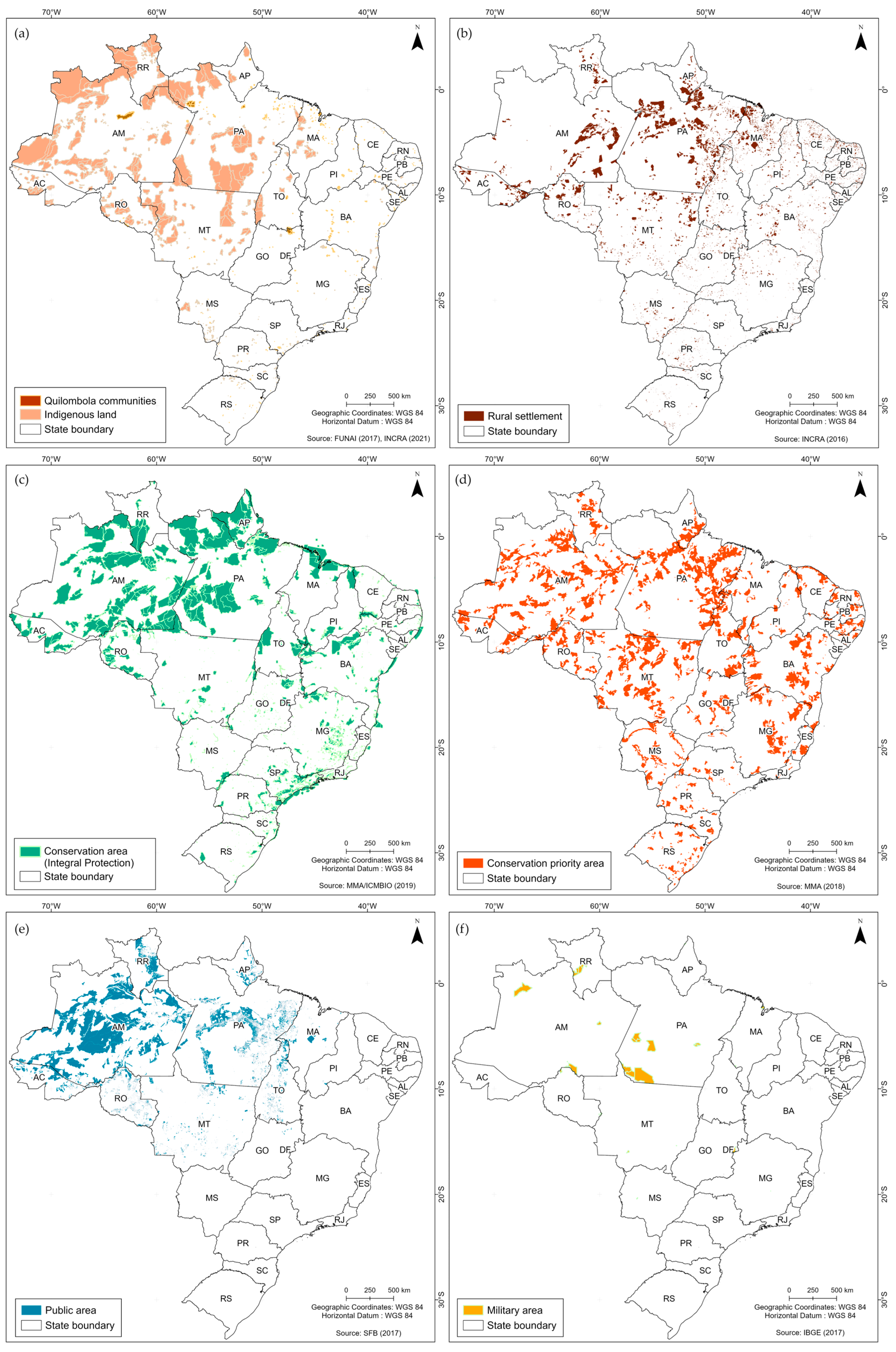
| Layer | Year | Scale | Source | Reference |
|---|---|---|---|---|
| Pasture quality | 2022 | 1:250,000 | Federal University of Goiás (UFG, Universidade Federal de Goiás) | [8] |
| Land natural agricultural potential | 2022 | 1:250,000 | Brazilian Institute of Geography and Statistics (IBGE, Instituto Brasileiro de Geografia e Estatística) | [37] |
| Indigenous lands | 2021 | 1:250,000 | National Indian Foundation (FUNAI, Fundação Nacional do Índio) | [38] |
| Afro-Brazilian settlements | 2021 | 1:250,000 | National Institute of Colonization and Agrarian Reform (INCRA, Instituto Nacional de Reforma Agrária) | [39] |
| Rural settlements | 2022 | 1:5000 | National Institute of Colonization and Agrarian Reform (INCRA, Instituto Nacional de Reforma Agrária) | [39] |
| Integral conservation | 2019 | 1:250,000 | Ministry of Environment and Climate Change (MMA, Ministério do Meio Ambiente e Mudança do Clima) | [40] |
| Biodiversity conservation | 2021 | 1:250,000 | Ministry of Environment and Climate Change (MMA, Ministério do Meio Ambiente e Mudança do Clima) | [41] |
| Public lands | 2020 | 1:250,000 | Brazilian Forest Service (SFB, Serviço Florestal Brasileiro) | [42] |
| Military lands | 2017 | 1:250,000 | Brazilian Institute of Geography and Statistics (IBGE, Instituto Brasileiro de Geografia e Estatística) | [43] |
| State and federal highways | 2021 | 1:400,000 | National Department of Transportation Infrastructure (DNIT, Departamento Nacional de Infraestrutura de Transportes) | [44] |
| Rural warehouses | 2021 | − | National Supply Company (CONAB, Companhia Nacional de Abastecimento) | [45] |
| Croplands | 2022 | 1:100,000 | MapBiomas Project (Brazilian Annual Land Use and Land Cover Mapping Project) | [3] |
| Climate risk agricultural zoning | 2023 | 1:50,000 | Ministry of Agriculture, Livestock, and Supply (MAPA, Ministério da Agricultura, Pecuária e Abastecimento) | [46] |
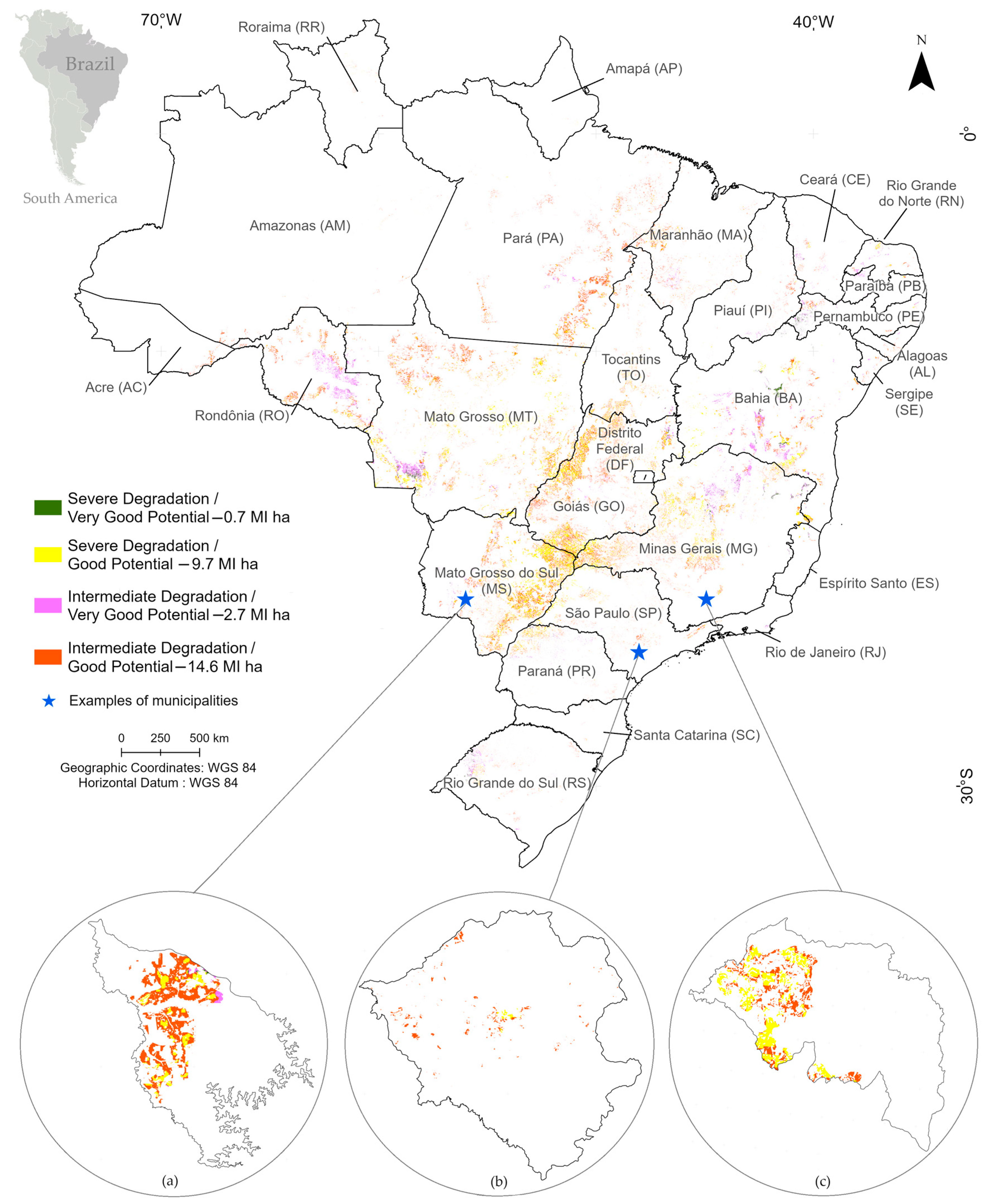
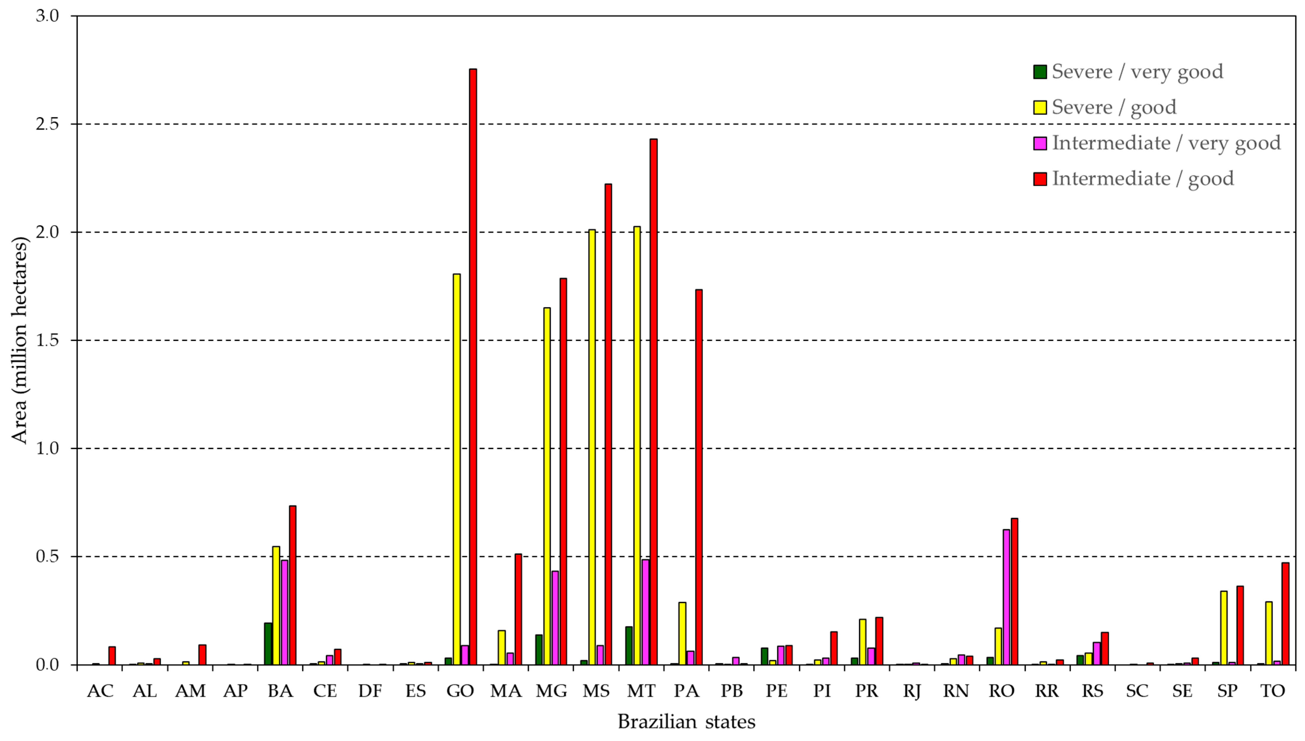
| Category | Potential | Characteristics |
|---|---|---|
| A1 | Very good | Deep soils, good fertility, good permeability, and location on flat terrains. |
| A2 | Good | Soils located mostly on flat terrains, with some restrictions because of the presence of undesirable/harmful ions and relatively shallow soil depth. |
| B | Moderate | Soils with moderate restrictions on fertility, presence of expansive clays and undesirable/harmful ions, mostly located on slightly hilly topography. |
| C | Restricted | Soils with undesirable/harmful ions, presence of expansive clays and with important restrictions regarding shallow soil depth, mostly located in rugged terrains, though they also can occur in flat areas with restrictions due to fluctuations or significant shallow water table (hydromorphism). |
| D | Strongly restricted | Soils located on terrains with very steep slopes, presence of undesirable soluble salts, and important restrictions regarding their depth; they are mainly devoted to protection, preservation, and conservation of native vegetation. |
| State * | State Area (Mha) | Pasture Quality Area (Degradation) | Natural Agricultural Potential Area ** | Special Areas (Mha) | Rural Infrastructure | Crop Area (2022) (Mha) | Number of Rainfed Crops with Low Climate Risk | Agricultural Crop Expansion Potential Area *** (Mha) | |||
|---|---|---|---|---|---|---|---|---|---|---|---|
| Inter-mediate (Mha) | Severe (Mha) | Good (Mha) | Very Good (Mha) | Warehouses (Number) | Highways (km) | ||||||
| AC | 16.42 | 0.30 | 0.02 | 1.30 | 0.01 | 12.85 | 14 | 1611 | 0.01 | 26 | 0.09 |
| AL | 2.78 | 0.58 | 0.10 | 0.19 | 0.07 | 0.71 | 73 | 895 | 0.34 | 28 | 0.04 |
| AM | 155.93 | 0.60 | 0.14 | 41.92 | 0.01 | 142.39 | 26 | 7273 | 0.01 | 19 | 0.11 |
| AP | 14.25 | 0.01 | 0.01 | 2.75 | 0.01 | 13.21 | 3 | 1197 | 0.02 | 17 | 0.01 |
| BA | 56.48 | 7.04 | 3.61 | 10.37 | 2.61 | 16.34 | 557 | 35,479 | 2.89 | 39 | 1.96 |
| CE | 14.89 | 1.51 | 0.32 | 1.33 | 0.68 | 3.50 | 84 | 14,975 | 0.59 | 26 | 0.13 |
| DF | 0.58 | 0.04 | 0.06 | 0.31 | 0.01 | 0.54 | 90 | 1772 | 0.11 | 34 | 0.00 |
| ES | 4.61 | 1.05 | 0.56 | 0.04 | 0.02 | 1.31 | 267 | 7751 | 0.27 | 31 | 0.03 |
| GO | 34.02 | 6.45 | 3.55 | 13.57 | 0.48 | 5.58 | 914 | 26,321 | 5.45 | 35 | 4.68 |
| MA | 32.96 | 2.60 | 0.57 | 10.9 | 0.47 | 13.47 | 167 | 15,067 | 1.19 | 30 | 0.73 |
| MG | 58.65 | 10.66 | 6.10 | 13.94 | 2.11 | 11.33 | 1387 | 43,447 | 4.84 | 33 | 4.01 |
| MS | 35.71 | 6.14 | 5.72 | 13.85 | 0.96 | 6.88 | 844 | 18,878 | 4.06 | 35 | 4.34 |
| MT | 90.32 | 8.92 | 7.01 | 41.45 | 2.05 | 39.21 | 2218 | 26,453 | 11.78 | 34 | 5.12 |
| PA | 124.59 | 6.62 | 1.33 | 56.52 | 1.16 | 104.64 | 138 | 19,091 | 1.01 | 28 | 2.09 |
| PB | 5.65 | 0.68 | 0.75 | 0.10 | 0.20 | 1.16 | 32 | 7400 | 0.07 | 28 | 0.05 |
| PE | 9.81 | 1.38 | 0.58 | 0.91 | 1.03 | 2.92 | 45 | 12,773 | 0.42 | 28 | 0.27 |
| PI | 25.18 | 1.12 | 0.33 | 4.41 | 0.29 | 5.58 | 136 | 4383 | 1.14 | 27 | 0.21 |
| PR | 19.93 | 1.10 | 0.48 | 3.69 | 2.43 | 3.36 | 2502 | 17,902 | 6.61 | 32 | 0.54 |
| RJ | 4.38 | 0.93 | 0.28 | 0.01 | 0.03 | 1.22 | 19 | 2375 | 0.12 | 31 | 0.01 |
| RN | 5.28 | 0.85 | 0.55 | 0.44 | 0.31 | 1.34 | 21 | 1802 | 0.44 | 28 | 0.12 |
| RO | 23.78 | 3.95 | 0.81 | 10.14 | 2.65 | 15.98 | 200 | 5845 | 0.37 | 29 | 1.50 |
| RR | 22.36 | 0.23 | 0.10 | 8.16 | 0.09 | 20.55 | 27 | 1825 | 0.11 | 20 | 0.04 |
| RS | 28.17 | 2.51 | 0.86 | 3.85 | 0.81 | 3.51 | 4652 | 26,353 | 8.92 | 34 | 0.35 |
| SC | 9.57 | 0.57 | 0.27 | 0.19 | 0.01 | 1.27 | 994 | 9579 | 1.24 | 32 | 0.01 |
| SE | 2.19 | 0.54 | 0.15 | 0.23 | 0.06 | 0.24 | 3 | 402 | 0.11 | 27 | 0.04 |
| SP | 24.82 | 2.05 | 1.67 | 7.56 | 0.73 | 5.17 | 1053 | 18,463 | 7.61 | 40 | 0.73 |
| TO | 27.74 | 3.71 | 1.70 | 4.10 | 0.14 | 12.98 | 176 | 15,770 | 1.32 | 31 | 0.79 |
| Total | 851.04 | 72.1 | 37.6 | 252.24 | 19.38 | 447.24 | 16,642 | 345.10 | 61.04 | - | 28.02 |
| Land Use | Infrastructure | Distance from Highways | |||||||
|---|---|---|---|---|---|---|---|---|---|
| 20 km | 40 km | 60 km | 80 km | 100 km | >100 km | Total | |||
| Agriculture | Warehouses | Area | 51.14 | 7.22 | 1.72 | 0.56 | 0.23 | 0.15 | 61.03 |
| % | 83.80 | 11.83 | 2.83 | 0.92 | 0.38 | 0.25 | 100.00 | ||
| Highways | Area | 57.10 | 3.34 | 0.48 | 0.11 | 0.00 | 0.00 | 61.03 | |
| % | 93.56 | 5.47 | 0.79 | 0.18 | 0.00 | 0.00 | 100.00 | ||
| Pasture | Warehouses | Area | 54.00 | 48.61 | 31.98 | 18.06 | 10.31 | 12.66 | 177.64 |
| % | 30.40 | 27.36 | 18.00 | 10.17 | 5.80 | 7.13 | 100.00 | ||
| Highways | Area | 158.63 | 14.95 | 2.84 | 0.77 | 0.35 | 0.10 | 177.64 | |
| % | 89.30 | 8.42 | 1.60 | 0.43 | 0.20 | 0.06 | 100.00 | ||
Disclaimer/Publisher’s Note: The statements, opinions and data contained in all publications are solely those of the individual author(s) and contributor(s) and not of MDPI and/or the editor(s). MDPI and/or the editor(s) disclaim responsibility for any injury to people or property resulting from any ideas, methods, instructions or products referred to in the content. |
© 2024 by the authors. Licensee MDPI, Basel, Switzerland. This article is an open access article distributed under the terms and conditions of the Creative Commons Attribution (CC BY) license (https://creativecommons.org/licenses/by/4.0/).
Share and Cite
Bolfe, É.L.; Victoria, D.d.C.; Sano, E.E.; Bayma, G.; Massruhá, S.M.F.S.; de Oliveira, A.F. Potential for Agricultural Expansion in Degraded Pasture Lands in Brazil Based on Geospatial Databases. Land 2024, 13, 200. https://doi.org/10.3390/land13020200
Bolfe ÉL, Victoria DdC, Sano EE, Bayma G, Massruhá SMFS, de Oliveira AF. Potential for Agricultural Expansion in Degraded Pasture Lands in Brazil Based on Geospatial Databases. Land. 2024; 13(2):200. https://doi.org/10.3390/land13020200
Chicago/Turabian StyleBolfe, Édson Luis, Daniel de Castro Victoria, Edson Eyji Sano, Gustavo Bayma, Silvia Maria Fonseca Silveira Massruhá, and Aryeverton Fortes de Oliveira. 2024. "Potential for Agricultural Expansion in Degraded Pasture Lands in Brazil Based on Geospatial Databases" Land 13, no. 2: 200. https://doi.org/10.3390/land13020200