Article

Water-Town Settlement Landscape Atlas in the East River Delta, China

1
School of Architecture and Art, Central South University, Changsha 410083, China
2
State Key Laboratory of Subtropical Building and Urban Science, Department of Landscape Architecture, School of Architecture, South China University of Technology, Guangzhou 510641, China
3
Faculty of Architecture, Civil and Transportation Engineering, Beijing University of Technology, Beijing 100124, China
*
Author to whom correspondence should be addressed.
Land 2024, 13(2), 149; https://doi.org/10.3390/land13020149
Submission received: 11 December 2023 / Revised: 12 January 2024 / Accepted: 25 January 2024 / Published: 27 January 2024
(This article belongs to the Special Issue Resilient Communities and Sustainable Development in Deltas)

Abstract

:
The water-town settlements in the East River Delta of China engage with the aquatic environment, establishing a comprehensive cultural–ecological system. However, rapid urbanization challenges the structural integrity of water-town settlements. Focusing on the East River Delta as the study area, we utilized the Normalized Difference Water Index (NDWI), settlement morphology indicators, systematic clustering, and graph classification methods. We conducted a quantitative analysis of the spatial characteristics of water-town settlements at various scales, followed by formulating a sequence encoding based on landscape factors and constructing a settlement landscape spatial map. We characterized the landscape spatial structure of water-town settlements formed through the gradual evolution of morphological water network structures, retracing a prototype of water-town settlement landscape spatial structures. Results: ① Water-town settlements exhibit distinct uniformity in the landscape spatial features. The settlement landscapes conform to water network patterns, with streets and alleys aligning with water bodies. Crucial elements, including docks, bridges, and waterside farmland, are integral to this landscape. ② Water-town settlements undergo three progressive differentiation phases based on their location. The spatial distribution of settlements reveals three distinct landscape features influenced by the delta’s dynamic interplay between water and land. ③ Various regions exhibit three typical settlement layouts: upstream settlements are mainly clustered and linear, while midstream and downstream settlements, characterized by linear and strip-like features, align with the river’s course. These research findings offer preliminary insights into landscape spatial prototypes, contributing valuable perspectives to the conservation and design of water-town settlements.

1. Introduction

The East River Delta is in the Pearl River Delta and lies at the core of the Guangdong–Hong Kong–Macau Greater Bay Area. Comprising a delta formed by the sedimentation of the East River, it has evolved into a densely woven water network through the combined forces of natural processes and human activities [1]. Water-town settlements, shaped under the influence of this distinctive natural environment [2], are vital subjects in studying human habitats in basins [3,4]. Water-town settlements, sculpted along the network of watercourses [5], exhibit a unique spatial organization, incorporating both riverine and maritime landscapes [6]. Encompassing rich natural and cultural landscape factors [7], they present multi-scale characteristics combining natural evolution with intentional landscape construction. Under the pressure of water-related challenges in the deltaic plains, water-town settlements establish a series of spatial patterns [8]. They serve as a crucial foundation for the construction of contemporary ecological civilizations in the rural areas1 of the Pearl River Delta region. Therefore, extracting water network information from the East River Delta’s water-towns [9] and quantitatively analyzing the landscape spatial features of water-town settlements2 are paramount. Based on the characteristics of landscape factors, forming a sequence encoding, classifying types, and constructing clustering diagrams contribute to exploring the formation texture and intelligent construction of settlement landscape spaces. These efforts aim to uncover patterns in construction, providing valuable insights into the ecological wisdom and philosophical aspects of the human–environment relationship within the water-towns of the East River Delta [10,11].
Scholars have conducted diverse studies on water-town settlements in the Pearl River Delta, with investigations spanning physical geography [12] and regional research in historical geography [13,14]. These studies have established the groundwork for exploring the relationship between water-town settlements and the water–land interface [15], forming the basis for the understanding that water-town settlements originate from water and flourish in its proximity. Research on water-town settlements in the Pearl River Delta can be classified into three dimensions: disaster-prevention landscapes, production landscapes, and living landscapes [16]. Within the field of disaster-prevention landscapes [17], discussions have delved into the mechanisms of flood disaster generation [18], specific disaster-prevention strategies, the resulting social culture of typical samples [19], and the integration of disaster-prevention methods into settlement morphology [20]. Concerning production landscapes, the discourse has covered pond landscapes unique to regional environments [21,22,23] and farmland landscapes [24,25,26]. Exploring living landscapes, the morphological characteristics of settlements resulting from changes in the water–land relationship [2,27,28,29,30], cultural settlement nodes [31,32,33], and landscape spatial features [34] collectively manifest richness. In summary, the existing research on water-town settlements in the Pearl River Delta predominantly concentrates on the West River Delta, North River Delta, and islands of the Pearl River Delta [35]. The research on the distinctive three-stage progressive change characteristics of water-town settlements in the East River Delta during their spatiotemporal evolution currently needs to be completed. Numerous studies utilize qualitative research methods, employing descriptive approaches to infer and summarize settlement characteristics. However, these studies frequently concentrate on individual samples of water-town settlements, creating a challenge in summarizing regional pattern features due to the limitations of a singular sample. Consequently, one needs to be proficient in the overall landscape characteristics of water-town settlements to comprehend them.
Quantitative investigations into water-town settlements are at a nascent exploratory stage, wherein researchers endeavor to scrutinize the spatial characteristics of traditional water-town settlement clusters [36,37] and assess the architectural value of water-town settlements [38]. Some have utilized metrics like shape rate, circularity, and aggregation to quantify the analysis of water-town settlement boundaries [39]. Others have synthesized the spatial patterns of settlements [40,41,42] and conducted quantitative analyses of settlement farming conditions [43]. While these quantitative methods offer valuable insights, they fall short of exploring the comprehensive characteristics of traditional settlements at the regional level. Therefore, further in-depth discussions on the regional features of water-town settlements in the East River Delta are imperative. In the dynamic interplay of water and land across different temporal and spatial scales in East River Delta water-towns, changes in environmental substrates interact with human adaptive activities [44], collectively shaping the landscape. Employing quantitative analysis to investigate the spatial distribution, settlement morphology, and composition of water-town settlements in the East River Delta contributes to a holistic, structural, hierarchical, and multidimensional understanding of the landscape spatial characteristics. Concurrently, crafting a landscape map [45] for an in-depth analysis of settlement landscape spaces in the study area facilitates the extraction, transformation, and comparison of uniform and differential landscape factors [46,47]. This exploration delves into the connections and differences of water-town settlement landscape factors within the same region, forming a regional map set of encoding sequences. This methodology fosters a more profound and comprehensive exploration of the prototypes and variations in water-town settlement landscape spaces in the East River Delta, guiding the development of optimal solutions based on the regional environmental characteristics of water-towns in the East River Delta [48]. Additionally, it provides recommendations for constructing a contemporary living environment in East River Delta water-towns, addressing issues such as the erosion of water-town settlements due to rapid urbanization and the gradual loss of the Lingnan water-town landscape.

2. Materials and Methods

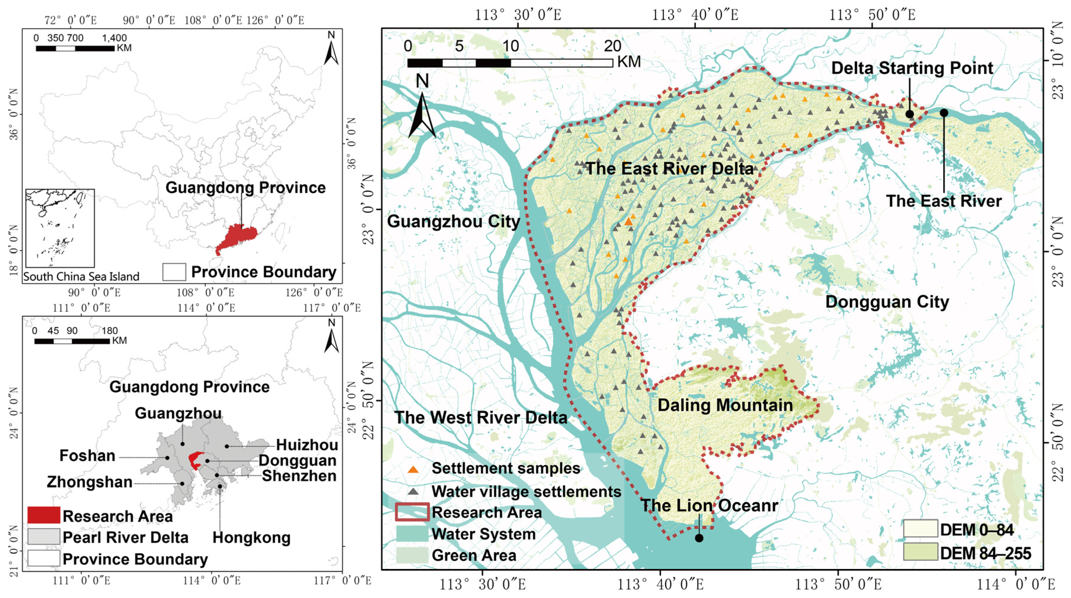
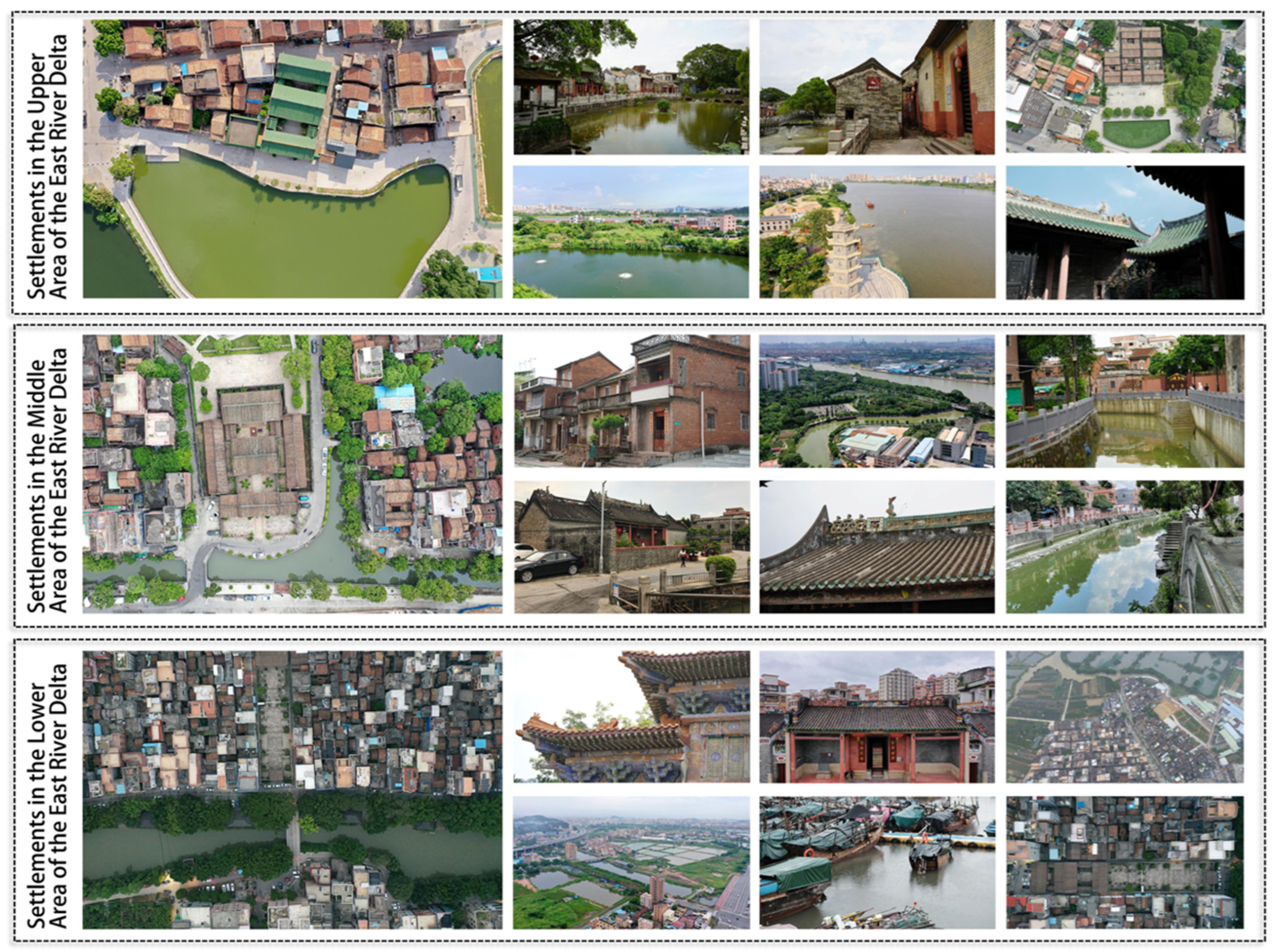
2.1. Study Area and Samples
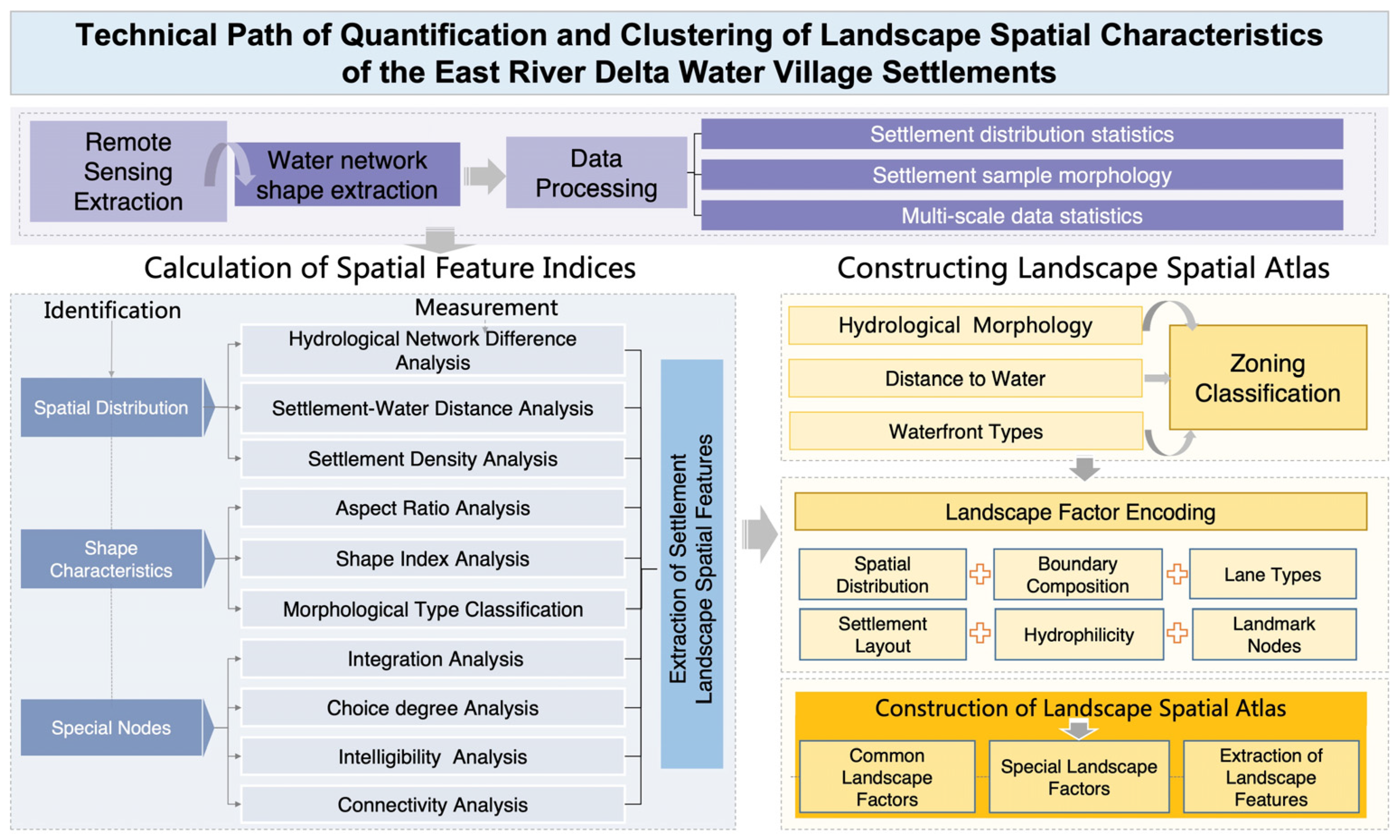
This paper delves into water-town settlements in the East River Delta. Distinctive features encompass ① a water network density of 1.9 km/km2, markedly surpassing the average water network density of 0.8 km/km2 in the “Pearl River Delta” region, with well-maintained water network relationships; ② from Figure 1, it is evident that there is a close correlation between settlements and water–land transitions, where water–land transitions serve as foundational conditions for the emergence of water-town settlements in the East River Delta. Settlement activities, in turn, facilitate the generation of land, making them a prototypical example for scrutinizing the interactive relationship between Lingnan water-town settlements and water systems; ③ as the sole independently formed delta in the Pearl River Delta, the land in the East River Delta traverses three water system types—rivers, river networks, and marine tides—over a short distance (Figure 1). Despite the impact of rapid, high-density urbanization, certain water-town settlements preserve their forms intact, offering a substantial and diverse sample size.
The East River Delta fronts the West River Delta and North River Delta across the Shi Zi Ocean, covering a total area of 555.73 km2. The geographical scope extends from Shi Long Town in Dongguan City as the apex, encompassing all the land between the main stream of the East River and its southern tributary (Figure 2). Administratively, the area includes 11 towns in Dongguan City, constituting a total of 175 settlements. To select representative samples of water-town settlements in the East River Delta, this study adhered to the following criteria: (1) selection of typical water-town settlements in the upstream, midstream, and downstream areas of the East River Delta as research cases; (2) ensuring water-town settlement samples encompass typical landscape factors, such as intact settlement forms, well-organized street and lane textures, well-preserved typical buildings, and abundant water-town nodes, reflecting the authenticity of water-town settlements. Additionally, by utilizing ArcGIS software 10.8 to process information on the central and typical basins of the East River Delta and following sample selection principles, 27 representative settlement samples were chosen in the upstream, midstream, and downstream areas of the East River Delta (Table 1), with the southern part of the downstream area excluded from sampling due to the less-evident water-town landscape caused by urbanization.

2.2. Methodology

This paper investigates the landscape spatial characteristics of water-town settlements in the East River Delta, employing landscape spatial feature indicators to encode landscape factors and develop a structural diagram illustrating the spatial arrangement of water-town settlements. By extracting the overall water network morphology and settlement layout of the East River Delta, this study analyzes the multi-scale hierarchical spatial relationship between changes in water network morphology and water-town settlements, thus delineating a technical pathway (Figure 3). First, we collected and extracted remote sensing data for the water network and settlement points in the East River Delta, along with historical maps. Second, we utilized water network and settlement data, in conjunction with map comparisons, to quantitatively analyze the landscape spatial characteristics of water-town settlements, categorized into three dimensions: ① We established multiple buffers to interconnect settlement spaces, analyzing the distribution of settlement spaces and their correlation with water systems. ② We extracted settlement boundaries, calculated aspect ratios, and computed shape indices to assess the hydrophilic strength. ③ We employed spatial syntax to calculate the layout within settlements and their relationship with water systems, scrutinizing the water usage characteristics of water-town settlements. Finally, based on quantitative indicators, we conducted cluster analysis, encoded landscape factors, and constructed a clustering diagram representing the spatial structure of water-town settlements.

2.2.1. Extraction of Remote Sensing Data for Water Networks and Settlement Points

The data employed in this paper encompass remote sensing data for water systems, elevation data, settlement morphology data, and internal node data. ① Extracting remote sensing data for water systems and elevation data: Employing the Google Earth Engine (GEE) platform (https://code.earthengine.google.com/, accessed on 13 August 2023), water body data were extracted, using the NDWI as a feature to establish a water body sample library for machine learning. In total, 70% of the samples were designated as training samples and 30% we designated as evaluation samples, verifying the overall accuracy through a confusion matrix, which exceeded 80%, with a kappa accuracy of 0.8. Simultaneously, a water body was selected by amalgamating the water body datasets generated from 4,716,475 scenes captured by Landsat5, Landsat7, and Landsat8 satellites. In this selection process, pixels identified with water for seven months in a year were considered water bodies. Through this methodology, water body raster data for the East River Delta were chosen and extracted, with the raster data being imported into ArcGIS. Referring to a list of significant rivers in Guangdong Province and local town records, a database was established by inputting the names and widths of four primary rivers, ten secondary rivers, forty-two tertiary rivers, and two marine waterways. ② Constructing settlement morphology data and internal node database: Following surveys and visits to water-town settlements conducted from 2020 to 2023, systematic data collection was performed. For the 27 selected samples, settlement morphology and architectural floor plans were delineated, and water-town node information for each settlement was detailed.

2.2.2. Quantitative Calculation of Water Settlement Landscape Spatial Features

To conduct a precise examination of the impact of water network changes on the spatial configurations of settlements across various scales and the adaptive strategies employed by settlements, and adhering to the principles of comprehensiveness and diversity, 27 samples were meticulously chosen from the upstream, midstream, and downstream regions of the East River Delta. At the regional scale, the analysis encompassed water network density and width, the distance between settlements and the water network, and the spatial distribution of settlement density. On the settlement scale, computations involved settlement aspect ratios and shape indices, enabling an analysis of the hydrophilicity strength and the subsequent classification of settlement layout types. On the node scale, the spatial syntax was utilized to calculate the integration, choice, connectivity, and intelligibility of settlement road networks, providing an insightful analysis of how internal settlement structures adapt to the water network dynamics (Table 2).

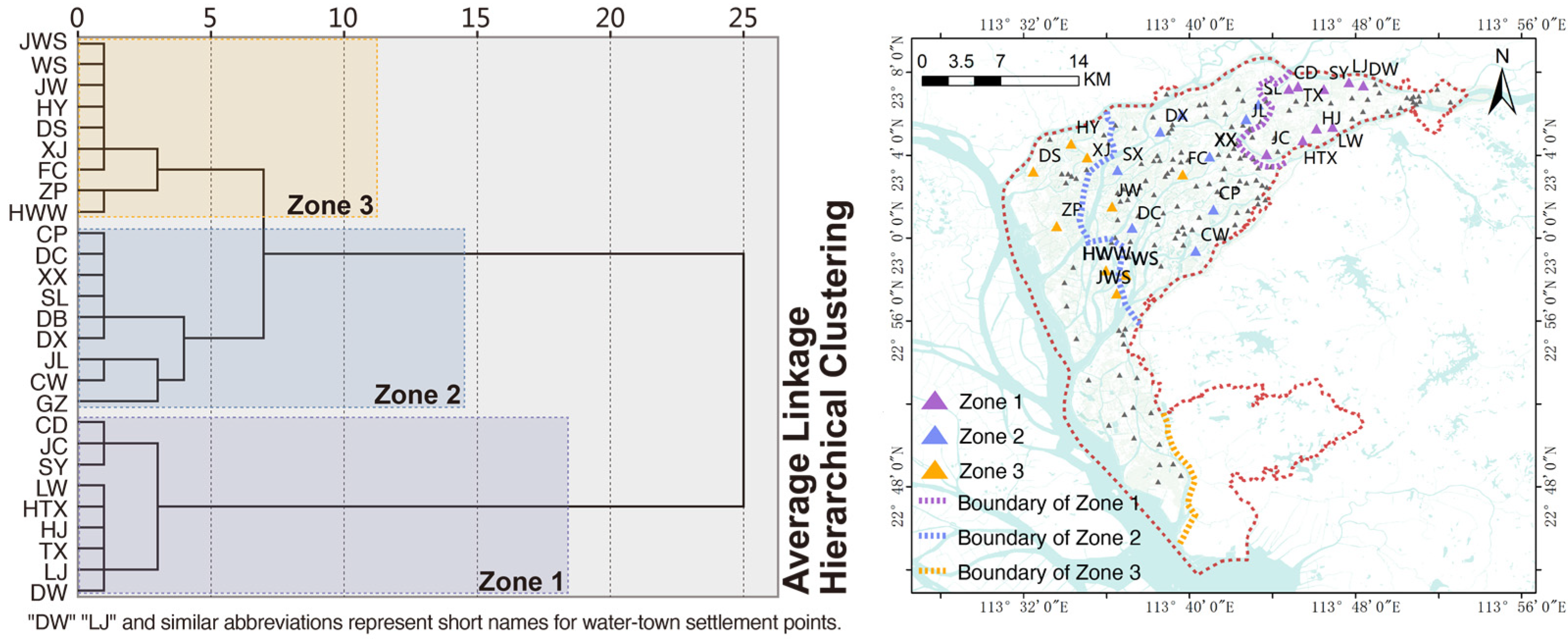
2.2.3. Construction of a Clustered Map for Water-Town Settlement Landscape Spatial Characteristics

Based on applying a systematic clustering method for delineating distinct regions, landscape factors were systematically categorized, culminating in forming a spatial map of the landscape.
① A systematic clustering analysis method was applied, utilizing three key indicators—water network density and width, the spatial distribution of settlement density, and distance between settlements and water networks—as foundational criteria. SPSS was employed for the clustering analysis, considering options such as systematic clustering, K-means clustering, and two-step clustering. Given this study’s limited sample size and the absence of outliers, the systematic clustering method was preferred. Based on the outcomes of water network density and width calculations, three distinct types were identified: ponds, rivers, and tributaries. Settlement density spatial distribution was classified into dense and sparse areas. The distance between settlements and water networks was categorized as more significant than 200 m, 20–200 m, and less than 20 m.
② Classification and encoding of landscape factors: Utilizing calculated settlement spatial morphology indicators and water-town settlements node information obtained through surveys, nine landscape factors—water network density, settlement spatial distribution, regional settlement density, settlement layout, street and lane types, street and lane centroids, landscape nodes, and typical structures—were systematically classified. Within these 9 factors, 30 specific element indicators were further delineated. Landscape factors underwent symbolization and digitization, with their attribute information systematically encoded.
③ Construction of settlement landscape spatial maps: The map was partitioned based on the regions outlined through systematic clustering analysis. Subsequently, the landscape factors characterizing the spatial arrangement of water-town settlements were abstracted and structured. Comparative analysis was conducted to elucidate the commonalities and differences in landscape factors across diverse regions.

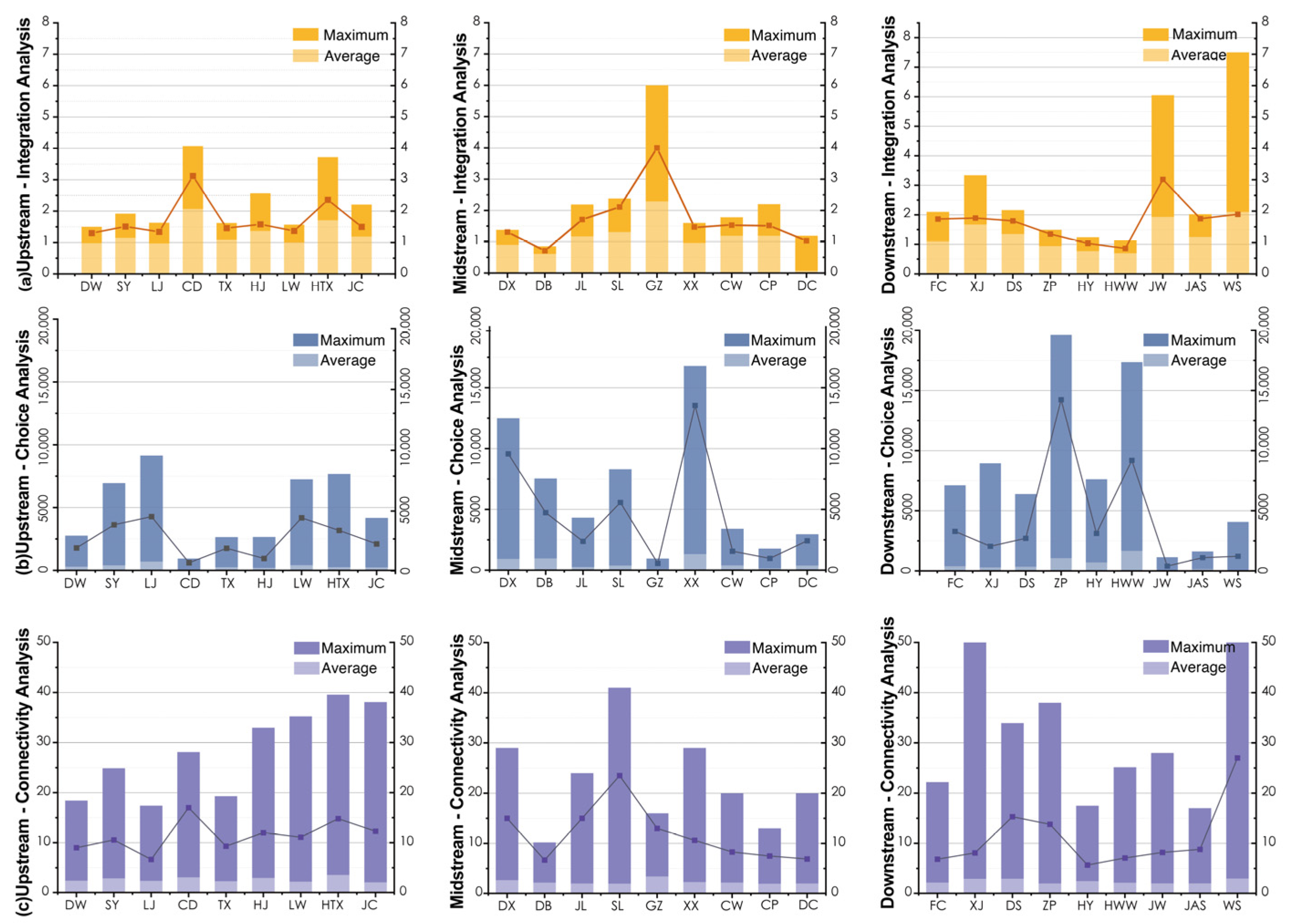
3. Water-Town Settlement Landscape Spatial Feature Quantification

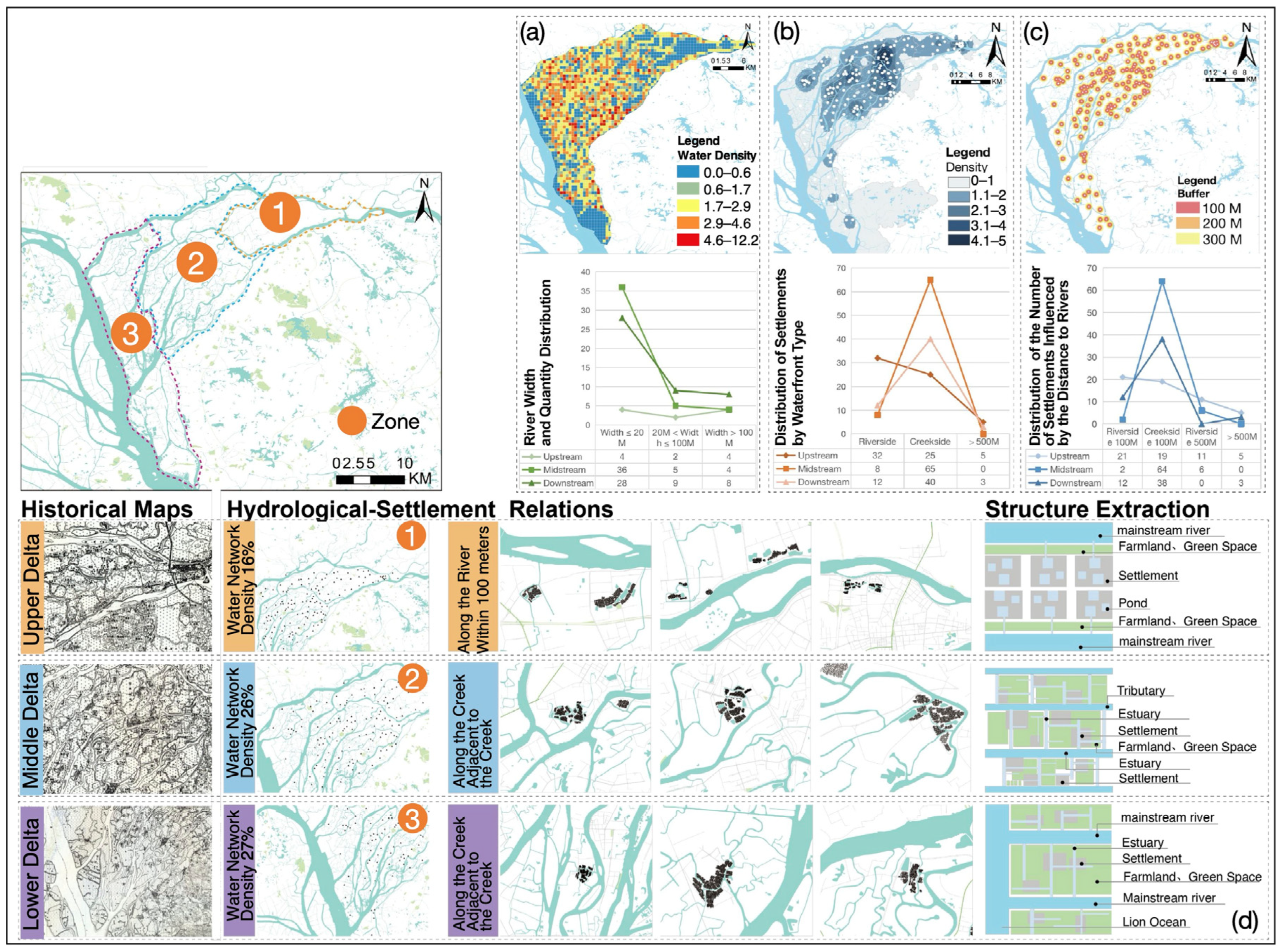
3.1. Characteristics of Settlement Spatial Distribution

As shown in Figure 4, the spatial distribution of water-town settlements in the East River Delta was obtained through quantitative analysis of water network density and width, settlement density, and the distance between settlements and water systems in the study area. Initially, the water network density and width in the delta exhibited a three-stage variation: the upstream had the lowest water network density and widest width, the midstream had the highest density and narrowest width, and the downstream had a high density with a gradual increase in width (Figure 4a). This pattern is primarily attributed to the prolonged land formation and abundant upstream sedimentation, resulting in two broad, main rivers dominating the landscape with fewer network branches. Moving downstream, the river width narrows, branches increase, and the proportion of land area decreases. In the downstream, influenced by tidal action near Lion Ocean, the river width gradually increases, branches spread, and the convergence of tributaries forms multiple main rivers.
Next, the spatial distribution density of settlements revealed that the midstream has the highest density, followed by the upstream, and the downstream has the least density (Figure 4b). This distribution is linked to extensive land deposition in the East River Delta since the Tang and Song dynasties, essentially shaped by the Ming and Qing dynasties. Consequently, sedimentation time is extended upstream and midstream, leading to longer settlement development and higher density. In the downstream, where formation time is shorter and proximity to the ocean results in significant tidal influences, land is predominantly used for farming and aquaculture, resulting in fewer settlements.
Lastly, the distance between settlements and water bodies gradually decreases from the upstream to the downstream regions (Figure 4c). Employing ArcGIS for buffer analysis of the water system in the East River Delta with a 100 m span, settlements along water bodies with a width less than 20 m constitute 64% of the total settlements, totaling 119. Settlements distributed along water bodies with a width greater than 100 m comprise 19%, totaling 35. The remaining settlements, with a distance greater than 200 m from water bodies, account for 17%. Overall, 83% of settlements in the East River Delta have close connections to water bodies.
In comparison, the remaining 17%, located in the inland areas of the upstream region, have a distance greater than 200 m from water bodies. Settlements along the river are concentrated upstream, while those along river channels are mainly found in the midstream and downstream areas of the river mouth. Consequently, the spatial structures of settlements upstream of the East River Delta exhibit a “linear” distribution along the main river. In contrast, settlements in the midstream and downstream regions demonstrate a “braided branch” distribution along the water network (Figure 4d).

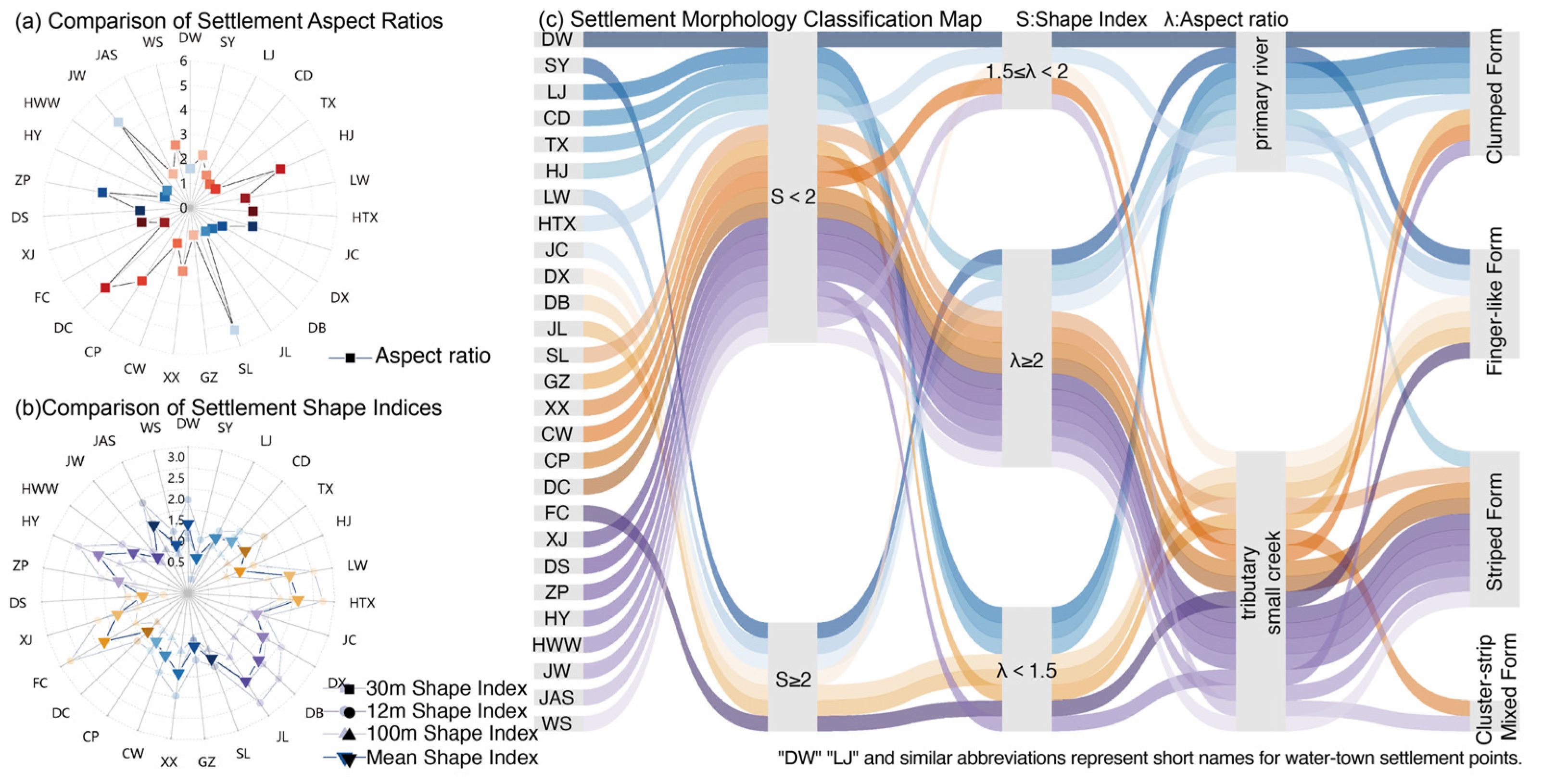
3.2. Settlement Morphological Characteristics

Through the computation and comparison of the aspect ratios and shape indices of 27 representative settlement samples, the relationship between settlements and the water network can be classified into two primary types: settlements adjacent to the main river and settlements adjacent to tributaries. Those near the main river can be further categorized into clustered and linear types, predominantly concentrated in the upstream region of the delta. Settlements near tributaries can be classified into linear and strip-like types, primarily concentrated in the midstream and downstream regions of the delta. Employing selected index calculation methods and adhering to settlement boundary drawing principles [49], the boundaries for each of the 27 typical settlement samples were initially drawn at 100 m, 30 m, and 12 m, with perimeter and area measurements for each boundary type. Subsequently, the aspect ratio (Figure 5a) and shape index for the 100 m, 30 m, and 12 m boundaries were calculated for each settlement. Weighted averages were then determined for the shape index of each settlement (Figure 5b). The aspect ratio, denoting the ratio of the long axis to the short axis, signifies the elongation of settlement morphology. The mean aspect ratio for the 27 settlement samples was 2.3, with JW, HJ, DC, and SL having the highest aspect ratios, primarily distributed in the midstream and downstream regions of the delta. The shape index, indicating boundary complexity and landscape spatial experience richness, averaged 1.72, with minor differences between regions. JL, HTX, LW, and FC exhibited the highest shape index values.
Following the morphological classification method, we initially screened each settlement’s average shape index and aspect ratio index. Building upon this foundation and considering the relationship between each settlement and the water network, we categorized the morphology of water-town settlements, as depicted in Figure 5c. Settlements adjacent to the main river are distributed upstream of the delta, primarily featuring clustered and linear forms, with pond-type water systems within the water-town settlements. This can be attributed to the dominance of the East River North Mainstream and East River South Tributary, both more comprehensive than 300 m, in the upstream water system of the delta. With a low river network density, the water supply within settlements relies on ponds, resulting in a layout predominantly characterized by clustered and linear forms to minimize the distance from water sources. Settlements near tributaries are mainly distributed midstream and downstream of the delta. In these areas, the river network is dense, with widespread branches providing adequate buffering against river floods and tidal effects. Consequently, settlements are less affected by water disasters, tend to be closely adjacent to water systems, and primarily showcase strip-like settlement forms and some linear forms, with river channels as the primary internal water systems. Overall, settlements tend to exhibit a strip-like and linear distribution trend along rivers, with buildings arranged perpendicular to the river. This is mainly attributed to the reliance on water transportation in agrarian societies and high demands for water convenience, reflecting the ecological wisdom of water-town settlements in agrarian societies.

3.3. Settlement Composition Characteristics

Riverside streets and alleys, as pivotal elements of water-town settlements, encapsulate the profound influence of water network morphology on settlement frameworks and the distribution of settlement nodes. Examining integration, choice degree, connectivity, and intelligibility across 27 water-town settlement samples using Depth Map 10, the mean integration values were primarily distributed between one and two (Figure 6). A comparison of these mean integration values with those of riverside streets and alleys consistently revealed higher integration values for the latter, underscoring the elevated spatial accessibility and centrality of these features in water-town settlements. Consequently, the arrangement of streets and alleys in settlements aligns with the patterns of water systems, and riverside streets and alleys function as the primary traversable spaces within settlements. Notably, settlements GZ, JW, and WS demonstrated the highest integration, with riverside streets and alleys exhibiting the utmost accessibility and centrality among all settlements, predominantly concentrated in the midstream and downstream regions of the delta (Figure 6a).
Concerning choice degree values, the choice degree of riverside streets and alleys in all samples surpassed the average choice degree value. These streets and alleys are the main spatial arteries within settlements, displaying robust connectivity with other streets and alleys. Mainly, settlements DX, XX, ZP, and HWW showcased the most developed riverside streets and alleys, providing the highest number of selectable paths. Each region boasts settlements with a relatively high choice degree, intricately linked to the developmental stage of the settlements and the extent of water network development within the water-town settlements (Figure 6b).
Regarding connectivity, the mean connectivity value for settlement road networks was 2.47, with average connectivity values for riverside streets and alleys consistently exceeding the overall mean settlement connectivity value (Figure 6c).
Intelligibility serves as an indicator of holistic spatial cognition. Settlements, such as CD, CW, DX, DS, and JW, distributed along a single water channel or featuring neatly arranged ponds in the samples, demonstrated high intelligibility. In contrast, settlements distributed along multiple ponds, including LJ, LW, SL, and ZP, exhibited lower intelligibility. Moreover, as illustrated in Figure 7, which shows the integration degree, choice degree, connectivity, and intelligibility of streets and alleys, it was evident that the main roads exhibiting the highest internal integration, pass-through rate, choice degree, and connectivity within settlements aligned with the pattern of internal water systems. This underscores a robust correlation between water systems and settlements’ principal streets and alleys.

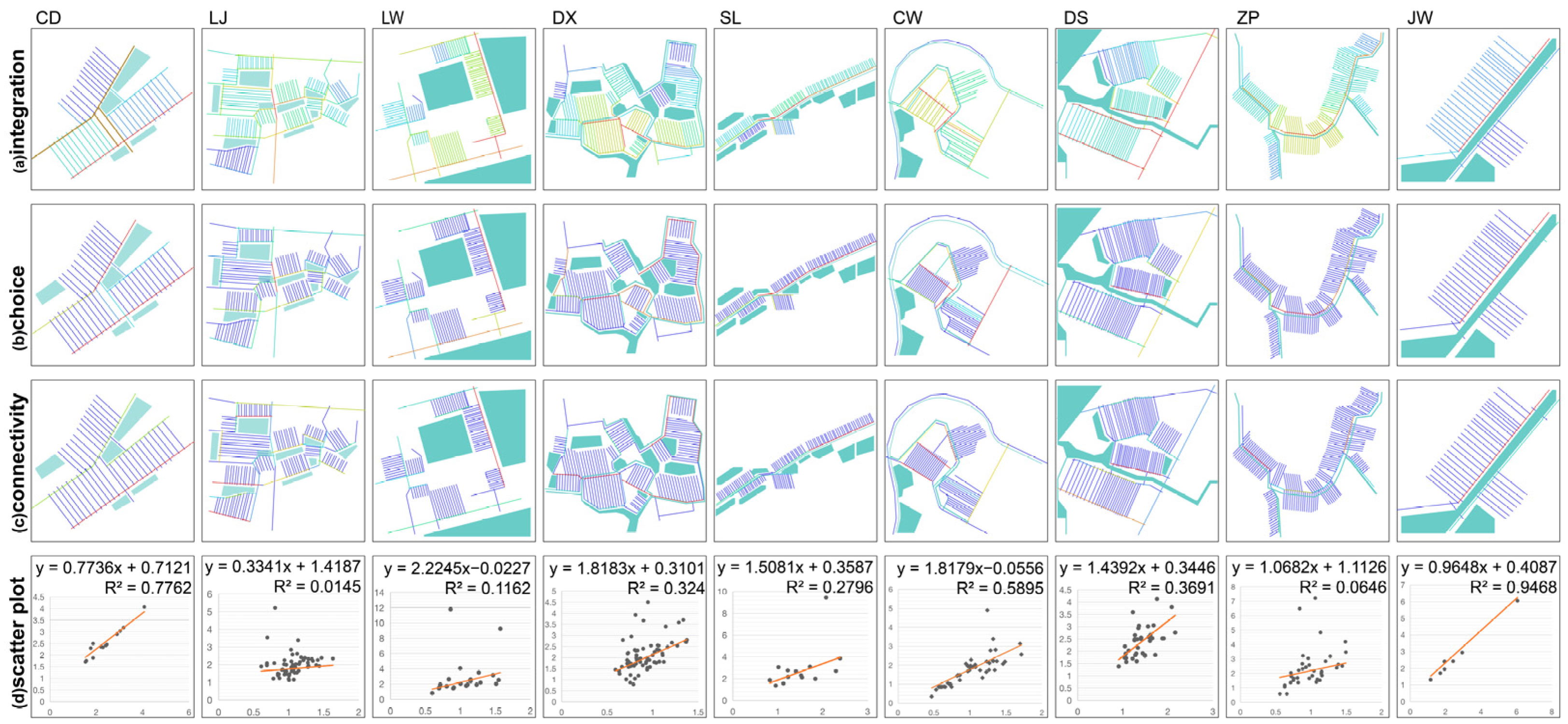
4. Water-Town Settlement Landscape Clustering Analysis and Map Construction

4.1. Water-Town Settlement System Clustering Analysis

To explore the characteristics of settlements under varying water system conditions, three indicators—settlement location, distance from the main river, and internal water system morphology—were employed for assessment. Utilizing the systematic clustering method, settlements underwent classification into distinct clusters, thereby segregating the settlement samples into three regions (Figure 8).
The settlement samples in Group One are predominantly located in the upstream area of the delta and are distinguished by their common feature of being positioned at the confluence of two rivers. These settlements exhibit a landscape structure characterized by a parallel and progressive pattern. The uniformity observed in settlements within this region can be attributed to the prolonged formation time and extensive land area upstream of the East River Delta with a sparse network of river branches. To ensure a stable water source and settlement safety, these settlements are often situated approximately 200 m from the main river. They maintain a parallel relationship with the river by incorporating green spaces, farmland, and parallel watercourses within the settlements.
The settlement samples in Group Two are situated in the midstream of the delta and are characterized by a limited land area exhibiting a leaf-like segmentation of the river network. These settlements are closely arranged along river channels. The development of this characteristic is primarily attributed to the high water-network density in the midstream of the East River Delta, coupled with a lower susceptibility to water-related disasters. Consequently, settlements in this region are frequently positioned near river channels, complemented by farmland and ponds that follow the natural water flow.
The settlement samples in Group Three are predominantly located in the downstream area of the delta and are marked by an expanded river network width and small rivers resembling a spiderweb scattered across the land. These settlements are arranged and surrounded by water systems. The formation of this feature is primarily influenced by tidal action downstream of the East River Delta. As the main rivers widen, settlements in this region are strategically positioned at a certain distance from the main river for safety reasons.

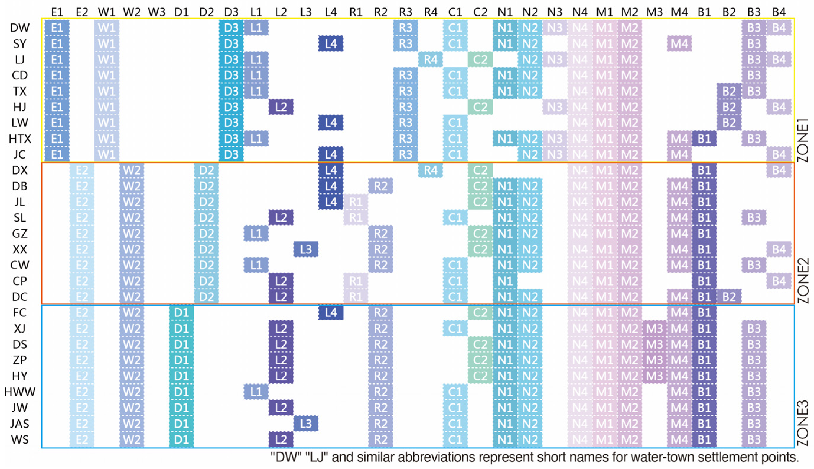
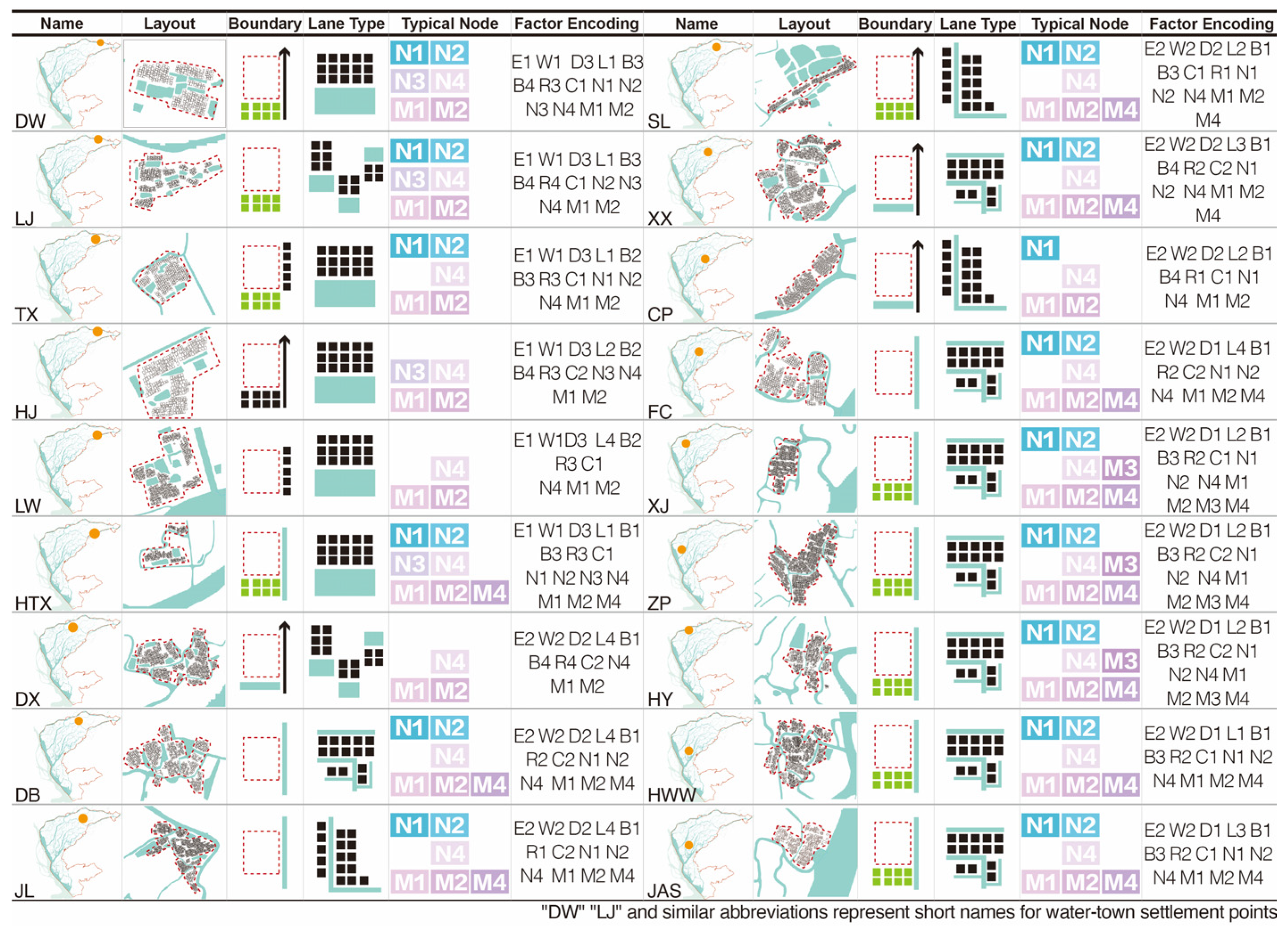
4.2. Encoding of Landscape Factors

Based on the calculations of the indicators above and the results of systematic cluster analysis, coupled with the findings from on-site research and investigation, this study undertook the encoding of landscape factors. The objective was to elucidate the spatial characteristics and patterns of water-town settlement landscapes in an abstract and organized manner using a common symbolic language. This research categorized nine primary aspects: water network density, settlement spatial distribution, settlement density, settlement layout, street and alley types, landscape nodes, typical structures, and boundary composition (as illustrated in Table 3). Subsequently, utilizing calculations and research findings, these aspects were further subdivided into thirty subcategories, each assigned a specific encoding value. The systematic cluster analysis outcomes organized these encoding values into three regions for presentation (Table 3).
Here is an analysis of the landscape factors:
Water network density: Regarded as one of the most pivotal natural factors in the East River Delta, water network density significantly influences water-town settlements. This factor was classified into <20% and >20%.
Settlement spatial distribution: this aspect mirrors the adaptive choices of the living environment in this region and encompasses three categories: riverside settlements, creek-side settlements, and non-water-town settlements.
Settlement density based on location: this factor manifests the settlement’s inclination toward its natural environment, categorized into low, medium, and high densities.
Settlement layout: This feature reflects the most advantageous layout adopted by settlements in their long-term natural development for resource acquisition, security assurance, and transportation facilitation. We categorized this into three groups: cluster settlements, strip settlements, cluster–strip hybrid settlements, and linear settlements.
Street and alley types: based on integration and intelligibility criteria, four street and alley layouts were identified: main streets along rivers, main streets circling rivers, main streets facing ponds, and main streets dispersed throughout.
Street and alley cores: settlements were categorized as having single-core or multi-core street and alley systems based on criteria such as choice degree and connectivity.
Landscape nodes: through on-site research, four typical landscape nodes were identified: embankments, farmlands, fengshui ponds, and ancient trees.
Typical structures: this category encompasses ancestral halls, temples, pavilions, and docks, representing cultural entities that have emerged within water-town culture.
Boundary composition: this aspect can reveal the connections between settlements and surrounding natural and artificial elements and is divided into four types: water bodies, structures, farmlands, and roads.

4.3. Construction and Prototype Extraction of Water-Town Settlement Landscape Spatial Atlas

The Water-town Settlement Landscape Spatial Atlas of the East River Delta is a comprehensive representation of the tangible spatial elements within settlements. It elucidates the inherent patterns shaped by landscape factors and offers a systematic and structural interpretation of the spatial characteristics of settlement landscapes. Employing systematic cluster analysis, the research area was partitioned into three segments, and landscape factors were methodically categorized and encoded to formulate the Water-town Settlement Landscape Spatial Atlas. Influenced by many factors, the water-town settlements in the East River Delta were categorized into three regions (Figure 9).
The water-town settlements within the three groups, grounded in shared features characteristic of water-towns, manifest progressively distinctive traits influenced by regional distinctions. The uniformity in settlement landscape space is underscored by the flat topography of the research area being devoid of hills, with alterations in water flow serving as a central influencing factor in shaping the landscape space. Consequently, water-town settlements are situated along water bodies, with farmland and water systems as customary boundary elements. Prominent landscape nodes within water-towns include farmland, ponds, and ancient trees. Additionally, ancestral halls, temples, and docks represent typical structures embodying cultural entities within water-town culture. The three progressively distinctive characteristics are delineated as follows (Figure 10):
Group One, situated upstream of the East River Delta, has land that originated in the Tang Dynasty and is encircled by two major rivers. With an average water network density of 16%, settlements predominantly align along the river, reaching peak density 100–200 m from the river. These settlements exhibit high density, often forming single-surname water-town settlements with cluster or finger-like layouts. Water is directed into the water-town settlements through water channels and ponds. At the same time, streets and alleys predominantly feature pond-facing layouts, creating distinctive fengshui pond landscape nodes, with ancestral halls strategically positioned along ponds.
Group Two, located in the midstream of the East River Delta, features a water system forming a leaf-shaped braided pattern with a narrower water network and an average water network density of approximately 26%. These settlements experience fewer water-related disasters and typically adopt strip and along-the-creek layouts. Streets and alleys primarily fall into two categories: along the river and circling the creek. Within the settlement, there is an abundance of bridges and waterfront docks.
Group Three, positioned downstream of the East River Delta, encounters a water network influenced by ocean tides, resulting in a widened main river. With a water network density of around 26%, settlements are situated at a certain distance from the main river, adopting a strip-shaped layout surrounded by river channels. Streets and alleys uniformly follow the circling-the-river type, with the distinctive landscape node being the “Pavilion,” a feature arising from the practical necessity of mixed settlements in the lower part of the delta.

5. Discussion and Conclusions

5.1. Discussion

The water-town settlements in the East River Delta embody a landscape shaped by the intricate interplay of natural environmental evolution and transformative human activities. The spatial arrangement of these settlements reflects human endeavors, illustrating how communities have adapted and been altered in response to the natural environment. The East River Delta has experienced rapid urbanization and economic development in the contemporary era, making it one of China’s most dynamic regions [50]. Preservation efforts for water-town settlements in this context pose significant challenges. The research results pave the way for discussions on water-town settlements in relevant deltas, providing valuable insights, particularly for addressing pressing issues within the Chinese context.
At the macro level, studying settlements in a region contributes to understanding the overall characteristics of settlements under similar natural conditions or within exact administrative boundaries [51]. Macro-level research can focus on administrative regions or specific natural topographies. This is significant for gaining insights into coordinating settlement preservation with natural and urban development in different natural or administrative regions [52,53,54]. However, these studies often remain from a regional perspective [55] and need a detailed understanding of the specific characteristics of settlement clusters. Therefore, this study argues that a multi-scale research perspective can provide references from macro to micro. The research focuses on the East River Delta, which is typical in terms of natural topography, settlement forms, and the level of urbanization. Despite recent proposals for protection plans, more research is needed to support the design of these plans. Hence, this study is dedicated to researching settlement clusters within the delta, aiming to supplement the landscape spatial characteristics of the East River Delta from a macro perspective.
Examining the landscape spatial characteristics of water-town settlements through both temporal and spatial lenses offers a remedy to the prevalent issue where research predominantly fixates on typical relics, disregarding the shared features of water-town settlement clusters. Present investigations into delta water-town settlements frequently zero in on individual cases [56], choosing subjects primarily from nationally recognized traditional villages or approaching research from anthropological and historical viewpoints [57]. Despite these case studies yielding abundant settlement samples for related research on delta water-town settlements, they have yet to transcend to a comprehensive perspective, neglecting the influence of regional backgrounds on settlements. This paper departs from conventional approaches, delving into regional history and employing geographic information technology. The selection of multiple indicators and classification methods aimed to scrutinize 27 typical water-town settlements. The objective was to furnish a macroscopic conceptual framework for conservation and utilization underpinned by specific practical foundations.
To unveil the distinctive water-town characteristics within the East River Delta region, this study employed quantitative analytical methods to extend the investigation into settlement patterns. Drawing inspiration from landscape genetics theory and deviating from the methodologies previously derived in related research experiences, this study applied quantitative indicators at varying scales to analyze landscape spatial patterns. The objective was to acquire spatial data on water-town settlements and to distill and summarize the mathematical characteristics of the spatial form structure. This approach sought to establish a reproducible, visually comparable quantitative calculation method and atlas, facilitating the derivation of conclusions regarding the landscape spatial characteristics of water-town settlements.

5.2. Conclusions

Water-town settlements in the East River Delta plain take shape on the distinctive topography of the Pearl River Delta. The manifested spatial characteristics of settlement landscapes, finely attuned to the natural environment, epitomize traditional settlement wisdom and construction methods tailored to the regional human living environments (Figure 11). This manifestation is primarily observable across three scales:
Regional level: At the regional level, the spatial distribution of water-town settlements unfolds a gradually evolving three-stage structure over time, responding to changes in the water and land and simultaneous natural variations. Analyzing the impact of water network density and water system width on settlements, the upstream region of the East River Delta exhibits low water-network density and comprehensive water systems, with settlements maintaining a safe distance of 100–200 m from water bodies. In the midstream and downstream areas, where the water network density is higher and water systems are narrower, settlements are often positioned proximate to water bodies. The distribution of settlements in the delta reveals higher density upstream and midstream due to the longer formation time of the land. At the same time, the downstream region is predominantly agricultural and comprises new urban areas formed later.
Settlement layout level: At the level of settlement layout, it can be categorized into four types: cluster, finger-like, strip, and cluster–strip hybrid. Among the 27 typical settlement samples, the upstream region of the delta predominantly features cluster and finger-like layouts, the midstream region primarily displays finger-like and strip layouts, and the downstream region is characterized by strip layouts.
Landscape structure and node level: The level of landscape structure and nodes can be divided into street and alley types and landscape nodes. Firstly, in street and alley types, the results from calculating integration, connectivity, comprehensibility, and selectivity indicate that waterfront streets and alleys constitute the core structures of settlement landscapes. Settlements tend to construct primary transportation routes along the water, reflecting the traditional use of water transport in water-town settlements. Secondly, in settlements, landscape nodes, including farmland, ancestral halls, pavilions, waterfront docks, bridges, etc., are the most prominent, typical, and common node types showcasing the water-town landscape.
Through clustering analysis, landscape factors were classified and a Landscape Spatial Atlas was constructed, categorizing water-town settlements in the East River Delta into three distinct categories. The outcomes included quantitative indicators and a structured atlas, offering refined benchmarks for regulating water-town landscapes and advancing delta plain water-town settlements.
The East River Delta, a vital component of the Pearl River Delta, has encountered challenges to its water-town landscape amidst rapid urbanization and industrialization [58,59]. While the overall spatial configuration of typical water-town settlements is adequately conserved, a discernible trend of urban encroachment upon these settlements has manifested. Certain water bodies and basins have suffered impairments due to modern transportation and technology advancements, leading to landscape homogenization. Traditional water-town settlement lifestyles have also experienced repercussions. Consequently, by scrutinizing the inherent interaction between the water network system and settlements; elucidating their adaptive characteristics; and conducting targeted, specific explorations of various water-town settlement types in this research area, it becomes feasible to contribute to preserving traditional Chinese water-town settlement culture. In contemporary China, innovative protective designs can be formulated and built upon this foundation, offering regional solutions for rejuvenating rural areas and preserving heritage. Simultaneously, this study aims to expand the scope of atlas research, providing data support for uncovering the landscape features of water-town settlements.

Author Contributions

Conceptualization, J.Z., F.Y. and X.T.; methodology, J.Z. and X.T.; software, J.Z. and S.X.; validation, S.X.; investigation, J.Z. and Z.Y.; data curation, J.Z. and X.T.; writing—original draft preparation, J.Z. and F.Y.; writing—review and editing, J.Z., F.Y. and Z.Y.; visualization, J.Z. and X.T.; supervision, F.Y.; project administration, F.Y.; funding acquisition, F.Y. All authors have read and agreed to the published version of the manuscript.

Funding

This work was funded by the National Natural Science Foundation of China (Grant No. 72174211, 51608535); the Hunan Provincial Natural Science Foundation (Grant No. 2018JJ3667); the Philosophy and Social Science Foundation of Hunan Province (Grant No. 19YBA347); and the Postgraduate Teaching Reform Project of Central South University (Grant No. 2020JGB139).

Data Availability Statement

The data presented in this study are available on request from the corresponding author. The data are not publicly available due to privacy restrictions.

Acknowledgments

The authors are grateful to the Editor and Reviewers for their valuable comments and suggestions.

Conflicts of Interest

The authors declare no conflicts of interest.

Notes

1
Ecological Civilization in Rural Area: In order to improve the environmental quality of rural areas and protect the ecological systems in the countryside, the Chinese government has set the goal of ecological civilization in rural development.
2
Water-town settlement: It is a special type of settlement, generally referring to communities in delta plain regions where water channels, specifically rivers, serve as transportation arteries, and boats are the primary mode of transport. These settlements preserve a well-maintained landscape and architectural style.

References

  1. Wu, J. Agriculture and Environment in the Ming Dynasty Pearl River Delta: Focusing on Technological Choices Under Environmental Pressure. J. South China Agric. Univ. (Soc. Sci. Ed.) 2006, 5, 127–134. [Google Scholar]
  2. Kuei-Hsien, L.; Anh, L.T.; Nguyen, K.V. Urban design principles for flood resilience: Learning from the ecological wisdom of living with floods in the Vietnamese Mekong Delta. Landsc. Urban Plan. 2016, 155, 69–78. [Google Scholar]
  3. DongGe, N.; Yan, J.; Liu, P.; Van den Toorn, M.; Fekete, A. Historical Water Management Strategies—Case Study of Traditional Villages in Southern China, Hunan Province. Land 2022, 11, 2107. [Google Scholar] [CrossRef]
  4. Li, Y.; Li, Y.; Fan, P.; Long, H. Impacts of land consolidation on rural human–environment system in typical watershed of the Loess Plateau and implications for rural development policy. Land Use Policy 2019, 86, 339–350. [Google Scholar]
  5. Scown, M.W.; Thoms, M.C. The discontinum of river networks: The importance of geomorphic boundaries. Landsc. Ecol. 2023, 38, 1307–1319. [Google Scholar] [CrossRef]
  6. Wu, J. The Ecological Environment of the Pearl River Delta Plain during the Ming and Qing Dynasties—A Discussion on Research Methods for Marine Ecological Environmental History. Marit. Hist. Res. 2015, 2, 217–236. [Google Scholar]
  7. Xu, Z.; Huang, D. Living Water: Study on Regional Characteristics of of Landscape of Water System in Pearl River Delta. South Archit. 2015, 03, 84–89. [Google Scholar]
  8. Chen, J.; Liu, Y. Coupled natural and human systems: A landscape ecology perspective. Landsc. Ecol. 2014, 29, 1641–1644. [Google Scholar] [CrossRef]
  9. Chen, K.; Liu, X.; Chen, X.; Guo, Y.; Dong, Y. Spatial characteristics and driving forces of the morphological evolution of East Lake, Wuhan. J. Geogr. Sci. 2020, 30, 583–600. [Google Scholar] [CrossRef]
  10. Wu, L. Introduction to Human Settlements; China Construction Industry Press: Beijing, China, 2001. [Google Scholar]
  11. Ma, R.; Wang, T.; Zhang, W.; Yu, J.; Wang, D.; Chen, L.; Jiang, Y.; Feng, G. Overview and progress of Chinese geographical human settlement research. Sci. Geogr. Sin. 2016, 26, 1159–1175. [Google Scholar] [CrossRef]
  12. Zeng, Z. Geomorphic Development of the Pearl River Delta; Jinan University Press: Guangzhou, China, 2012. [Google Scholar]
  13. Zhao, H. Evolution of the Pearl River Estuary; Ocean Press: Flagler Beach, FL, USA, 1990. [Google Scholar]
  14. Li, P. Environmental Changes in the Pearl River Delta over Ten Thousand Years; Ocean Press: Flagler Beach, FL, USA, 1991. [Google Scholar]
  15. Wu, H. Research on the Interaction between Urban Development and Ecological Environmental Changes in the Ming and Qing Dynasties in the Pearl River Delta; Changjiang Publishing House: Wuhan, China, 2014. [Google Scholar]
  16. Wei, C.; Zhong, Z.; Liao, H. The Last Waterfront in Pearl River Delta”: Space Generation and Cultural Ecological Characteristics of Traditional Village in Gulao Waterfront. South Archit. 2021, 4, 97–104. [Google Scholar]
  17. Liu, J.; Zhang, M.; Xia, Y.; Zheng, H.; Chen, C. Using agent-based modeling to assess multiple strategy options and trade-offs for the sustainable urbanization of cultural landscapes: A case in Nansha, China. Landsc. Urban Plan. 2022, 228, 104555. [Google Scholar] [CrossRef]
  18. Wu, J. Water environment of cities and towns in the pearl river delta during the ming and qing dynasties. J. South China Agric. Univ. (Soc. Sci. Ed.) 2006, 2, 133–141. [Google Scholar]
  19. Pan, Y.; Duan, J.; Shi, Y. A Study on Traditional Disaster-Resistant Landscape Patterns in Traditional Han Chinese Settlements in Guangdong. South Archit. 2021, 3, 130–136. [Google Scholar]
  20. Zhang, Z. Analyzing the Morphology of Traditional Lingnan Water Villages under Flood Pressure—A Case Study of Four Villages in the Pearl River Delta. J. Archit. 2017, 1, 102–107. [Google Scholar]
  21. Liu, T.; Wang, X. Agricultural Landscape-Oriented Study of Regional Landscape in the Taihu Lake Basin Water Network Plain Area. Landsc. Archit. 2015, 8, 6. [Google Scholar]
  22. Chen, C.; Huang, G.; Ye, Y.; Zhao, L.; Jin, L.; Liu, X. Evolution of the Pearl River Delta Pond System and Ecological Restoration Strategies: A Case Study of 4 Villages in Foshan. Resour. Sci. 2021, 43, 13. [Google Scholar]
  23. Wang, C.; Huang, S.; Miao, J.; Wang, X. Study on the evolution characteristics and driving factors of the landscape pattern of the foundation pond in the Pearl River Delta—A case study of Shunde District, Foshan. Chin. Landsc. Archit. 2022, 38, 75–80. [Google Scholar]
  24. Zhang, S.; Zhu, X.; Wu, D.; Lu, Q. Reconstruction and Comparative Study of Historical Sections of the Shatian Culture Landscape in the Pearl River Delta. Chin. Landsc. Archit. 2021, 37, 6. [Google Scholar]
  25. Zhao, S.; Yang, Z. History of Embankment Water Conservancy and Agricultural Development in the Pearl River Delta; Guangdong People’s Publishing House: Guangzhou, China, 2011. [Google Scholar]
  26. Tu, Y.; Chen, B.; Yu, L.; Song, Y.; Wu, S.; Li, M.; Wei, H.; Chen, T.; Lang, W.; Gong, P.; et al. Raveling the nexus between urban expansion and cropland loss in China. Landsc. Ecol. 2023, 38, 1869–1884. [Google Scholar] [CrossRef]
  27. Shi, Y.; Pan, Y. Comparison of Traditional Settlement Forms between Jiangnan Water Town and Lingnan water town. South Archit. 2011, 3, 70–78. [Google Scholar]
  28. Tang, X.; Tao, Y. The Traditional Settlement Form of Foshan Songtang Village. South Archit. 2014, 6, 52–55. [Google Scholar]
  29. Gou, S.; Li, Z.; Zhao, Q.; Nik, M.V.; Scartezzini, J.L. Climate responsive strategies of traditional dwellings located in an ancient village in hot summer and cold winter region of China. Build. Environ. 2015, 86, 151–165. [Google Scholar] [CrossRef]
  30. Hu, X.; Li, H.; Zhang, X.; Chen, X.; Yuan, Y. Multi-dimensionality and the totality of rural spatial restructuring from the perspective of the rural space system: A case study of traditional villages in the ancient Huizhou region, China. Habitat Int. 2019, 94, 102062. [Google Scholar] [CrossRef]
  31. Pan, J.-f.; Qiu, L. The Analysis and Construction of Landscape Space in Lingnan Waterfront Settlement. Chin. Landsc. Archit. 2011, 27, 55–59. [Google Scholar]
  32. Feng, J. Cultivation, Lineage Settlements and Transition of Ancestral Halls in Canton Prefecture during Ming and Qing Dynasty. Ph.D. Thesis, South China University of Technology, Guangzhou, China, 2012. [Google Scholar]
  33. Fu, J.; Tang, X. Humanistic Landscape Types and Cultural Connotations in the Mulberry Orchard Area of the Pearl River Delta in the Ming and Qing Dynasties. Landsc. Archit. 2020, 27, 115–120. [Google Scholar]
  34. Wang, J.; Chen, J.; Xie, C. Landscape Evolution and Construction of Coastal Township in Lingnan Taking Nanlang Town of Zhongshan as an Example. Chin. Landsc. Archit. 2022, 4, 56–61. [Google Scholar]
  35. Tang, X.-x.; Wang, X.; Yang, D.-h. Study on Natural Adaptability of Coastal Rural Settlement Landscape—A Case Study of Hainan. South Archit. 2021, 5, 138–143. [Google Scholar]
  36. Nie, Z.; Li, N.; Pan, W.; Yang, Y.; Chen, W.; Hong, C. Quantitative Research on the Form of Traditional Villages Based on the Space Gene-A Case Study of Shibadong Village in Western Hunan, China. Sustainability 2022, 14, 8965. [Google Scholar] [CrossRef]
  37. Li, X.; Yang, Q.; Lyu, X.; Ye, Y.; Zhang, B. Multidimensional framework for analyzing the distribution patterns of traditional villages in the karst landscape regions of China. Ecol. Inform. 2023, 77, 102184. [Google Scholar] [CrossRef]
  38. Fu, J.; Zhou, J.; Deng, Y. Heritage values of ancient vernacular residences in traditional villages in Western Hunan, China: Spatial patterns and influencing factors. Build. Environ. 2021, 188, 107473. [Google Scholar] [CrossRef]
  39. Li, Y.; Zhu, Y.; Zhou, Y. Quantitative Research on Village Spatial Morphological Characteristics Based on Fractal Theory: A Case Study of Villages in Nanning. South. Archit. 2020, 5, 64–69. [Google Scholar]
  40. Zhang, Y.; Baimu, S.; Tong, J.; Wang, W. Geometric spatial structure of traditional Tibetan settlements of Degger County, China: A case study of four villages. Front. Archit. Res. 2018, 7, 304–316. [Google Scholar] [CrossRef]
  41. Ma, H.; Tong, Y. Spatial differentiation of traditional villages using ArcGIS and GeoDa: A case study of Southwest China. Ecol. Inform. 2022, 68, 101416. [Google Scholar] [CrossRef]
  42. Fan, M.; Wang, X.; Yang, G. Spatial characteristics of vegetation habitat suitability and mountainous settlements and their quantitative relationships in upstream of Min River, southwestern of China. Ecol. Inform. 2022, 68, 101541. [Google Scholar] [CrossRef]
  43. Dobrovodská, M.; Kanka, R.; David, S.; Kollár, J.; Špulerová, J.; Štefunková, D.; Mojses, M.; Petrovič, F.; Krištín, A.; Stašiov, S.; et al. Assessment of the biocultural value of traditional agricultural landscape on a plot-by-plot level: Case studies from Slovakia. Biodivers. Conserv. 2019, 28, 2615–2645. [Google Scholar] [CrossRef]
  44. Chen, L.; Zhong, Q.; Li, Z. Analysis of spatial characteristics and influence mechanism of human settlement suitability in traditional villages based on multi-scale geographically weighted regression model: A case study of Hunan province. Ecol. Indic. 2023, 154, 110828. [Google Scholar] [CrossRef]
  45. Hu, Z.; Liu, P.; Deng, Y. Research on Identification and Extraction Methods of Traditional Settlement Landscape Genes. Sci. Geogr. Sin. 2015, 35, 1518–1524. [Google Scholar]
  46. Chen, X.; Xie, W.; Li, H. The spatial evolution process, characteristics and driving factors of traditional villages from the perspective of the cultural ecosystem: A case study of Chengkan Village. Habitat Int. 2020, 104, 102250. [Google Scholar] [CrossRef]
  47. Liu, P.; Zeng, C.; Liu, R. Environmental adaptation of traditional Chinese settlement patterns and its landscape gene mapping. Habitat Int. 2023, 135, 102808. [Google Scholar] [CrossRef]
  48. Tang, X.; Zhang, J.; Xu, S. Scale-Level Representation of the East River Delta Water-town Landscape. South. Archit. 2023, 4, 89–95. [Google Scholar]
  49. Pu, X. Research on Quantitative Methods for Two-Dimensional Overall Morphology of Traditional Rural Settlements. Ph.D. Thesis, Zhejiang University, Hangzhou, China, 2013. [Google Scholar]
  50. Shen, J.; Wong, K.-y.; Feng, Z. State-Sponsored and Spontaneous Urbanization in the Pearl River Delta of South China, 1980–1998. Urban Geogr. 2002, 23, 674–694. [Google Scholar] [CrossRef]
  51. Kılıc, D.; Yagci, C.; Iscan, F. A GIS-based multi-criteria decision analysis approach using AHP for rural settlement site selection and eco-village design in Erzincan, Turkey. Socio Econ. Plan. Sci. 2023, 86, 101478. [Google Scholar] [CrossRef]
  52. Amos, S.; Mengistu, S.; Kleinschroth, F. Three decades of pastoralist settlement dynamics in the Ethiopian Omo Delta based on remote sensing data. Hum. Ecol. 2021, 49, 525–537. [Google Scholar] [CrossRef]
  53. Sun, Y.; Zhai, B.; Saierjiang, H.; Chang, H. Disaster adaptation evolution and resilience mechanisms of traditional rural settlement landscape in Xinjiang, China. Int. J. Disaster Risk Reduct. 2022, 73, 102869. [Google Scholar] [CrossRef]
  54. Liu, H.; Li, X.; Guan, Y.; Li, S.; Sun, H. Comprehensive Evaluation and Analysis of Human Settlements’ Suitability in the Yangtze River Delta Based on Multi-Source Data. Int. J. Environ. Res. Public Health 2023, 20, 1354. [Google Scholar] [CrossRef]
  55. Xi, J.; Wang, X.; Kong, Q.; Zhang, N. Spatial morphology evolution of rural settlements induced by tourism. J. Geogr. Sci. 2015, 25, 497–511. [Google Scholar] [CrossRef]
  56. He, Y.; Chen, C.-P.; Chou, R.-J.; Luo, H.; Hou, J.-S. Exploring the Transformation in the ‘Spirit of Place’ by Considering the Changed and Unchanged Defensive Spaces of Settlements: A Case Study of the Wugoushui Hakka Settlement. Land 2021, 10, 490. [Google Scholar] [CrossRef]
  57. Hinojosa-Balino, I. Urban Fluctuations in the North-Central Region of the Nile Delta: 4000 Years of River and Urban Development in Egypt. Ph.D. Thesis, University of Durham, Durham, UK, 2022. [Google Scholar]
  58. Liu, Z.; Wu, J. Landscape-based solutions are needed for meeting water challenges of China’s expanding and thirsty cities. Landsc. Ecol. 2022, 37, 2729–2733. [Google Scholar] [CrossRef]
  59. Liu, Z.; He, C.; Zhou, Y.; Wu, J. How much of the world’s land has been urbanized, really? A hierarchical framework for avoiding confusion. Landsc. Ecol. 2014, 29, 763–771. [Google Scholar] [CrossRef]
Figure 1. Relationship diagram of historical land development and settlement formation in the study area.
Land 13 00149 g001
Figure 2. Study area boundary map. (The research area included Da Ling Mountain, which is not within the land area of the East River Delta. However, it falls under the jurisdiction of the same town, Hu Men Town, within the East River Delta, and has historically had close connections with the coastal areas, which is why it was retained.)
Land 13 00149 g002
Figure 3. Technical pathway diagram.
Land 13 00149 g003
Figure 4. Spatial distribution characteristics of settlements. (a) Examination of water network density and river width; (b) assessment of settlement density and distribution and their correlation with the water system; (c) map illustrating the distribution of settlements in proximity to rivers; (d) systematized connection between water networks and settlements derived from the analysis of historical maps and the interplay between settlement distribution and water systems.
Land 13 00149 g004
Figure 5. Chart depicting the morphological classification of settlements. Based on the following: (a) Aspect ratio comparison chart, which can reflect the elongation of the outline of settlements. (b) Shape index comparison chart; the higher the numerical value of the shape index, the more complex the boundary. (c) Water-town settlement morphological feature division chart, which can be classified into cluster–strip mixed form, striped form, finger-like form, and clumped form.
Land 13 00149 g005
Figure 6. Integration, choice degree, and connectivity maps of settlement samples in the upstream, midstream, and downstream of the delta. (a) Integration: the average values of waterfront streets and alleys were higher than the overall settlement average. (b) Choice degree: the choice degree of waterfront streets and alleys was most developed within the settlements. (c) Connectivity: the connectivity of waterfront streets and alleys was the highest among all settlement components.
Land 13 00149 g006
Figure 7. Illustration of waterfront streets and alleys index: (a) integration degree; (b) choice degree; (c) connectivity; (d) intelligibility.
Land 13 00149 g007
Figure 8. Cluster analysis results. The left figure, through iterative updating of cluster centers, utilizes settlement location, the distance between settlements and the main river, and the morphology of water systems within settlements as criteria, resulting in the division of three regions as shown in the right figure.
Land 13 00149 g008
Figure 9. Creating the Landscape Spatial Atlas for Water-town Settlements involved assigning codes, such as E1, E2, and so forth, with the specific details available in Table 3. The atlas is organized based on the three regions determined by the results of the cluster analysis.
Land 13 00149 g009
Figure 10. Coding and prototype extraction of landscape spatial features for water-town settlements: Utilizing common genes identified in the atlas, we selected 18 sets of typical settlements and extracted their coding and prototypes. This presentation highlights the morphology, characteristic forms, and corresponding codes of settlements in various regions.
Land 13 00149 g010
Figure 11. Field survey images of water-town settlements in the upstream, midstream, and downstream areas of the East River Delta.
Land 13 00149 g011
Table 1. River and settlement sample distribution.
LocationSub-WatershedSettlement NameLocationSub-WatershedSettlement Name
UpstreamEast River Main ChannelDan Wu (DW), Sha Yao (SY), Liang jia (LJ), Cao dun (CD), Tang Xia (TX)DownstreamSouth Branch of the East RiverFu Chong (FC)
South Branch of the East RiverHeng Jiao (HJ), Liu Wu (LW), He Tian-Xia (HTX), Jiang Cheng (JC)Ma Chong River, Dao Yunhai WaterwayXin ji (XJ)
East River Main ChannelDa sheng (DS)
MidstreamZhong Tang Waterway, Heng ChongDong Xiang (DX), Dong Bo (DB)Danshui River, Shi Ziyang WaterwayZhang Peng (ZP)
Zhong Tang WaterwayJiao li (JL), San Lian (SL), Guo Zhou (GZ)Ma Chong River, East River Main ChannelHua yang (HY)
South Branch of the East RiverXiao Xiang (XX), Cai Wu (CW), Chang ping (CP)East Sea of Tai Yangzhou, West Sea of Tai YangzhouHong Wu-wo (HWW), Jin wo (JW)
South Branch of the East River, East Sea of Tai YangzhouDan Chong (DC)East Sea of Tai Yangzhou, South Branch of the East RiverJin Ao-sha (JAS), Wu sha (WS)
Table 2. Table of spatial quantitative indicators.
Spatial ScaleComputational ApproachesFormula
Spatial DistributionMulti-ring buffer analysis: establish buffers at different distances, connect them with the spatial distribution of settlements, and analyze the relationship between settlements and water systems spatially. B i = m d ( m , N ) r
Let B be the buffer zone, m be a point within the buffer zone, N be the settlement, d be the distance from m to N, and r be the radius.
Kernel Density Analysis: A higher kernel density value indicates a denser distribution of water-town settlements in the area. f x = 1 n h i 1 n k x x i h
where f(x) is the kernel density value, n is the sample size, and k(x) is the kernel function.
Settlement LayoutAspect ratio: utilizing the aspect ratio to calculate the ratio of the long and short axes under boundary conditions of 100 m, 30 m, and 12 m for settlement, aiming to classify the settlement morphology. λ = a b
λ ” represents the aspect ratio of the water-town settlement boundaries, with “a” being the long axis of a water-town settlement boundary and “b” being the short axis of a water-town settlement boundary.
Shape index: utilizing data on the aspect ratio, area, and perimeter, the shape index of settlements is categorized for the classification of settlement forms.S = P ( 1.5 λ λ + 1.5 ) λ A π
“S” represents the shape index, “P” is the perimeter, and “A” denotes the area.
Street and Alley TypesIntegration: Reflecting the concentration and dispersion degree of settlements, a higher integration degree indicates stronger spatial accessibility and centrality. It is used to assess the accessibility and centrality of waterfront streets in settlements. I = 2 ( i 1 n d i j ( n 1 ) 1 ) n 2
“I” represents integration; “n” represents the total number of axes or nodes in the spatial system.
Choice degree: Reflects the shortest topological distance between spatial entities, embodying the potential for spatial traversal. Higher choice values indicate greater potential for spatial flow. D n = 2 n log 2 ( n + 2 3 1 ) + 1 ( n 1 ) ( n 2 )
“Dn” represents choice degree.
Intelligibility: Describes the relationship between local space and overall spatial variables. Higher intelligibility indicates that the local spatial structure is more conducive to an understanding of the overall space. R 2 = ( I ( 3 ) I ( 3 ) ) ( I ( n ) I ( n ) ) ( I ( 3 ) I ( 3 ) ) 2 I ( n ) I ' ( n ) 2
“R2” stands for intelligibility, where “I(3)” and “I′(3)” represent the local integration and average integration for a step size of n = 3, respectively. “I(n)” and “I′(n)” denote the global integration and average global integration, respectively.
Connectivity: representing the number of axes intersecting with any axis in the system, higher connectivity indicates stronger axis accessibility. L x = X R x y
“LX” represents connectivity, where “Rxy” denotes the relationship between axis line x and axis line y in the system.
Landscape nodes and typical structuresMeasurement data and real-life photos were obtained through field surveys and inspections.
Table 3. Encoding of landscape spatial factors in water-town settlements.
Landscape Factor IndicatorsEvaluating Criteria
Water network density<20%→E1≥20%→E2
Settlement spatial distributionRiverside→W1Creek-side→W2Non-water-town→W3
Settlement densityLow→D1Medium→D2High→D3
Settlement layoutClustered→L1Strip-like→L2Clustered-strip hybrid→L3Linear→L4
Street and alley typesMain Street Along River Type→R1Main Street Around River Type→R2Main Street Pond Surface Type→R3Main Street Scattered Type→R4
Street and alley core areasSingle core→C1Multi-core→C2
Landscape nodesPond→N1Farmland→N2Fengshui pond→N3Ancient trees→N4
Typical structuresAncestral hall→M1Temple→M2Pavilion→M3Ferry terminal→M4
Boundary compositionWater→B1Structure→B2Farmland→B3Road→B4
Disclaimer/Publisher’s Note: The statements, opinions and data contained in all publications are solely those of the individual author(s) and contributor(s) and not of MDPI and/or the editor(s). MDPI and/or the editor(s) disclaim responsibility for any injury to people or property resulting from any ideas, methods, instructions or products referred to in the content.

