Article

Forest in Mozambique: Actual Distribution of Tree Species and Potential Threats

by
Eugénia Joaquim-Meque
1,
José Lousada
2,3,
Margarida L. R. Liberato
4,5 and
Teresa F. Fonseca
2,6,*
1
Instituto de Educação a Distância (IED), Universidade Católica de Moçambique (UCM), Rua Correia de Brito, Nº 613, Pontâ-Gea CP 90, Beira 2102, Mozambique
2
Departamento de Ciências Florestais e Arquitetura Paisagista (CIFAP), Universidade de Trás-os-Montes e Alto Douro, Quinta de Prados, 5001-801 Vila Real, Portugal
3
Centro de Investigação e de Tecnologias Agro-Ambientais e Biológicas (CITAB), UTAD, Quinta de Prados, 5001-801 Vila Real, Portugal
4
Departamento de Engenharias, Universidade de Trás-os-Montes e Alto Douro, Quinta de Prados, 5001-801 Vila Real, Portugal
5
Instituto Dom Luiz (IDL/UL), Faculdade de Ciências, Universidade de Lisboa, 1749–016 Lisboa, Portugal
6
Centro de Estudos Florestais (CEF), Instituto Superior de Agronomia, Universidade de Lisboa, Tapada da Ajuda, 1349-017 Lisboa, Portugal
*
Author to whom correspondence should be addressed.
Land 2023, 12(8), 1519; https://doi.org/10.3390/land12081519
Submission received: 18 May 2023 / Revised: 6 July 2023 / Accepted: 6 July 2023 / Published: 31 July 2023

Abstract

:
In recent decades, there has been a perception that the Mozambican forests have been threatened with massive exploitation for commercialization, deforesting vast areas, leading to desertification and contributing to the extinction of some forest species. The present research summarizes the official information obtained by monitoring the country’s natural resources over time and identifying the major types of existing forests in Mozambique. The main objective is to elucidate on the current state of Mozambican forests, analyze change and trends, and characterize the actual distribution of forest species in Mozambique to verify the sustainability of forest resources and their composition. It is a case study of the qualitative descriptive type, with data obtained through a bibliographic research method focusing on scientific articles on the type of forest species existing in Africa and Mozambique and data from official sources of the forests. Various types of forests were identified, such as mopane, mercrusse, semi-deciduous, miombo, and semi-evergreen, including the gallery forest. Forest species with particular relevance were highlighted, such as Afzelia quanzensis, Swartzia madagascariensis, Pterocarpaus angolensis, Combretum imberbe, and Millettia stuhalmannii. Major threats to these natural resources were identified and reported, including anthropogenic activity associated with traditional practices of illegal logging or due to the valuation of other goods of primary necessity, lack of protection and conservation measures, and impacts resulting from climate change. The Munza district is presented as a case study, carrying out a characterization of the forest in this district and identifying the main threats in the study area from 2015 to 2020.

1. Introduction

Forests are resources for addressing SDGs related to sustainable production and consumption, poverty alleviation, food security, biodiversity conservation, and climate change [1]. The African territory has different types of climate: equatorial, tropical, desert, and Mediterranean. The equatorial climate occurs in the western region, the tropical climate in the central and southern regions, and the desert climate and the Mediterranean climate in the northern region. This variety impacts the continent’s forests, characterized by equatorial forests, savannahs, and Mediterranean and steppe vegetation [1]. Despite the value attributed to forests and wealth, their sustainability has been threatened in recent decades.
Africa had the highest annual net forest loss rate from 2010–2020 at 3.9 million ha, followed by South America at 2.6 million ha. The rate of net forest loss has increased in Africa in each of the three decades since 1990, from 3.28 million ha in 1990–2000 to 3.40 million ha in 2000–2010, to 3.94 million ha in the last decade [1].
The risk factors are diverse, from massive exploitation by man—creating desertification, which has generated severe environmental problems—to climate change, which is a potential factor for the extinction of some forest species. In Mozambique, in particular, some forests are in an advanced state of exploitation not only by the state for the creation of agricultural fields and enterprises but also by the population, for whom the forest still constitutes a considerable part of their livelihood not as a direct support to agriculture but also as a source of raw material used in housing construction. In addition to these threats, some contractual concessions for logging may increase deforestation. Mozambique is affected by several disasters caused by natural phenomena such as floods, droughts, cyclones, and earthquakes. Some of these phenomena are cyclical, while others are occasional. Cyclones, droughts, and floods are due to the climatic influence of the country, dictated by the subtropical anticyclones of the Indian Ocean, the Inter-Tropical Convergence Zone, thermal depressions of southern Africa, and the passage of cold fronts in the south [2].
For informed decision-making, information must be available. This information is dispersed and originates from different sources, making it difficult to obtain answers to crucial questions such as: (a) How have Mozambique’s forests evolved in recent decades? (b) Have changes in forest composition or health status been reported? (c) What are the main threats to the sustainability of the country’s forest resources?
In this study, the authors intend to characterize the forests of Mozambique and the main threats to them. The first part presents an overall description and analysis at the country level. A real case follows, corresponding to the district of Muanza. Forest resources are characterized, and the main threats in the study area are identified from 2015 to 2020. The research was based on bibliographic contributions on forestry and threats to Africa in general and Mozambique in particular to understand the evolutionary process of forests in Mozambique in recent decades, namely on forest cover changes, the composition of tree species, and influential factors that might impact the sustainability of these natural resources. To conduct this review, we searched the b-on platform—which most publishers access—including Web of Science and Science Direct in the online knowledge library. We focused on theoretical contributions discussing forests and climate threats in African and South American contexts using the keywords forest, forest species, and climate threats. Out of 97 documents found, we selected 34 with relevant information. Our research was supported by working through these 34 documents. We used some publications to understand forest aspects and describe the species in each Mozambique region (30) and others to provide examples (4).

2. The Forest in Mozambique
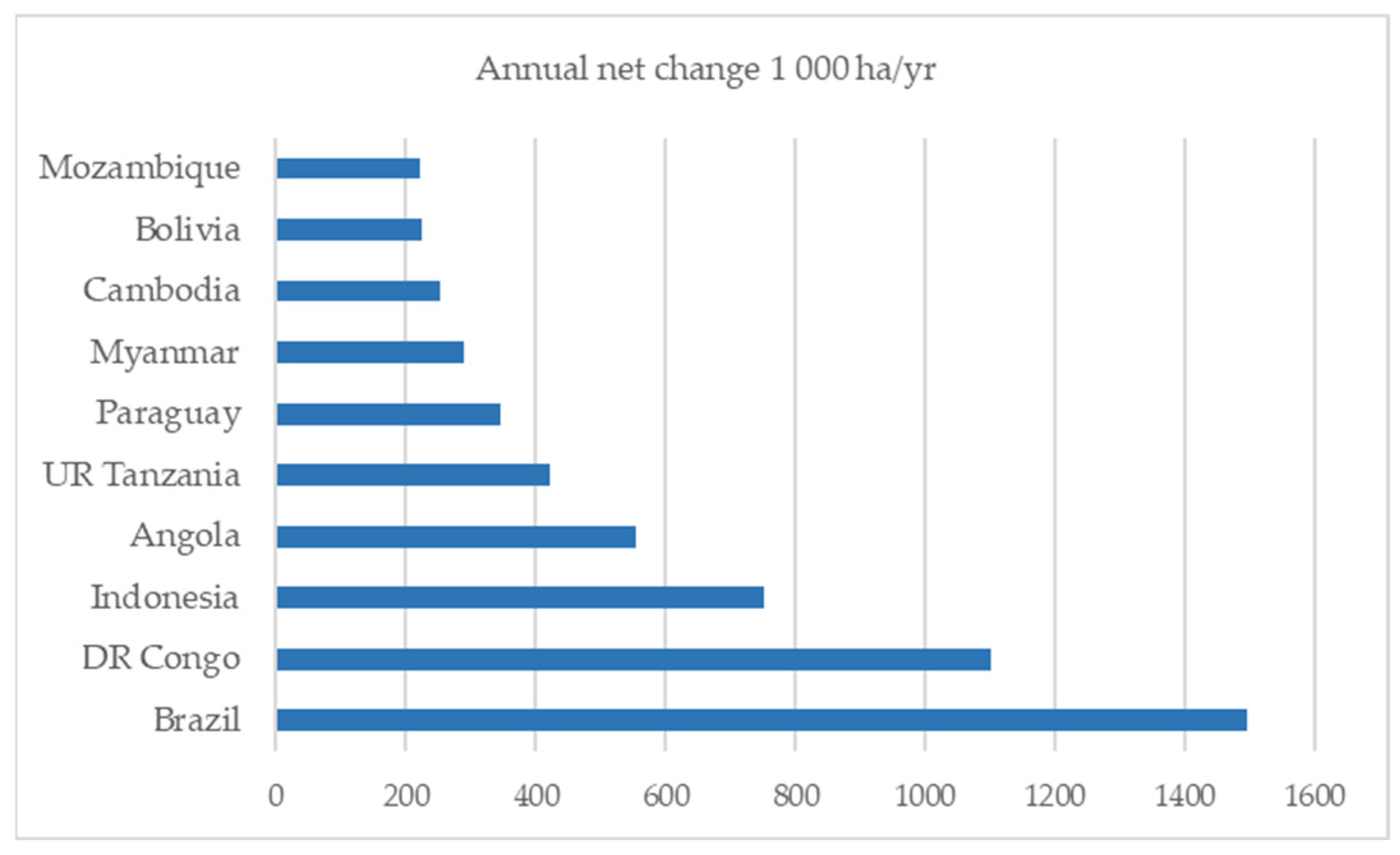
Mozambique is located on the southern coast of Africa and has a surface area of 799,380 km2, where 786,380 km2 is land, and the remaining 13,000 km2 is inland water. It is delimited as follows: to the north by Tanzania; to the west by Malawi, Zambia, and Zimbabwe; to the south by South Africa and the Swahili Kingdom; and finally to the east by the Indian Ocean (Figure 1). Three types of relief can be distinguished: the coastal plain, which occupies 40% of the territory and is the region with the highest concentration of population; the plateaus, with altitudes varying between 200 and 1000 m; and the mountains [3]. As for the soils, in the northern region, frank reddish clayey soils predominate, which are also permeable soils with good drainage; in the central region of the country, weak sandy, clayey soils predominate, as is evident in the Zambezi River, where the soils are fluvial with fertility. In the south, low-fertility soils are found, also with low water-retention capacity, mixed with white fluvial and marine sandy soils [2]. The reddish clay loamy soils are vulnerable to erosion in some of the other regions in which they occur.
Most of Mozambique is located in the inter-tropical zone, giving it a tropical climate with four variations—tropical wet, dry, tropical semi-arid, and climate modified by altitude [4]. The country has two seasons: the rainy season from October to April and the dry season, which is more demarcated in the central and northern regions of the country. The average precipitation varies from values below 400 mm—for example, in Pafuri, Gaza province—to 2000 mm in Tacuane, Zambezi province [4].

2.1. Forest Area

Mozambique is a country with substantial forest cover. The most recent inventory carried out in the country at the time of this study, NFI 2018, was conducted by the Ministry of Land, Environment, and Rural Development (MITADER) [5]. In the NFI 2018, the forest definition considers a canopy cover of more than 30%, a minimum area of 1 hectare, and trees that are at least 3 m tall. The inventory was carried out from 2015 to 2017 by restricted stratified random sampling where forest types were defined as strata (see Section 2.2 for further information). Of a planned total of 992 sample units, 855 were observed and considered valid (details are presented in [5]). Although estimates were also given at the provincial level, source [5] states that they are relatively less precise than the ones provided by forest types.
Based on the latest national inventory [5], the country has an estimated forest area of 77,601,072 hectares. Table 1 shows the county’s existing forest areas in the country by province, according to source [5]. The Niassa province has the most extensive forest cover, with around 7890 thousand hectares, while the Maputo province has the smallest area, with 2629 thousand hectares.
According to the FAO FRA database, the national data point value for the reference year of 2018 embraces not only forests but also other wooded land and other land (https://fra-data.fao.org/assessments/fra/2020/MOZ/originalDataPoints/2018/extentOfForest (accessed on 12 January 2023)). The FRA definition of forest is land spanning more than 0.5 hectares with trees higher than 5 m and a canopy cover of more than 10 percent, or trees able to reach these thresholds in situ. The stratum does not include land that is predominantly under agricultural or urban land use. The definition of other wooded land is similar to forest, lowering the canopy cover to 5–10 percent, or with a combined cover of shrubs, bushes, and trees above 10 percent. The adjusted figures in Mozambique, considering the FRA classes, lower the forest area to 37,224,170 ha and assign a value of 16,037,080 ha to the other wooded land class. To facilitate comparison among both sources of data, it is advisable to refer to the FAO FRA database, which provides information on the reclassification.
While it has a large forest area, Mozambique has shown a high net loss of its forest. The country is in tenth place in the top ten countries with net forest loss (Figure 2), with loss calculated to be 223 thousand hectares per year [1].

2.2. Major Forest Strata

Mozambique has forests composed of miombo, mecrusse, and mopane. These tropical dry forests are subject to high rates of deforestation and forest degradation due to their fragility, the high demand for goods and services, and the fact that they are the primary means of livelihood of the poor population [5]. The IV national forest inventory of Mozambique lists four types of forests in the country: mopane and mecrusse forests, semi-deciduous forest where miombo is included (FSDIM), and semi-evergreen forest, including the gallery forest (FSSV).
Mopene is a forest type with one predominant species whose specific epithet gives this forest type its name: Colophospermum mopane. This forest formation typically occurs on heavy textured soils in low-altitude flat river valleys, such as the Limpopo and Zambezi Rivers [5]. This forest type is found at altitudes varying from 200 to 1200 m but is more concentrated at altitudes varying from 300 to 900 m [5]. It is found mainly in Tete, Gaza, Inhambane, and Manica provinces.
Mecrusse is a forest type in which the main species, often the only one, in the upper stratum (canopy) is Androstachys johnsonii [6], with a relative cover ranging from 80 to 100% [5]. Androstachys Johnsonii is an evergreen species [6], the only member of the genus Androstachy in the family Picrodendraceae. This forest type is mainly found in the provinces of Inhambane and Gaza [6].
The semi-deciduous forest type, including miombo woodland, is, as denoted by its name, composed of the miombo woodland (dry) and other semi-deciduous forest formations, excluding the mopane forest type. As miombo woodland is Mozambique’s most predominant forest formation, covering 2/3 of the total forest area [7], it covers a larger proportion of the FSDIM stratum than other semi-deciduous forest formations. The miombo dry and semi-deciduous forest is the only forest type that cannot be identified by reflection characteristics in optical imaging because it is a deciduous forest mainly composed of species of the genus Brachystegia [5].
Figure 2. Top ten countries for annual net forest loss, 2010–2020 [8]. Source: by E. M. from various sources.
Land 12 01519 g002
The semi-evergreen forest (FSSV) forest type includes mountain forests, gallery forests, and semi-evergreen forests that are neither mountain nor gallery forests, which are only mainly composed of evergreen species. The mountain forests, as defined by FAO, are found at altitudes ranging from 300 to 2500 m with a sudden change in elevation over a short distance [5].
In Mozambique, there are several species of trees distributed throughout all regions, marketed locally but also exported, such species being called chanfuta (Afzelia quanzensis), umbila (Pterocarpaus angolensis); pau-ferro (Swartzia madagascariensis), mondzo (Combretum imberbe), and jambirre (Millettia stuhalmannii). The NFI [5] offers information on the distribution of trees across various diameter classes, as depicted in Figure 3. These data are essential for maintaining the sustainability and equilibrium of commercially important tree species in both domestic and global markets.
There are still native forests in Mozambique that have not yet been exploited due to the population’s inexistence and because it is considered a state conservation area under the protection of national parks and reserves.

2.3. Growing Stock

The total volumes per unit area for the forest types mopane, mercrusse, semi-deciduous forest including miombo, and semi-evergreen forest including gallery forest were 45.76, 85.36, 71.12, and 84.98 m3/ha, respectively, corresponding to an overall average of 72.01 m3/ha [5]. The above forest types’ commercial volumes per unit area were 15.71, 33.18, 24.23, and 31.69 m3/ha, respectively [5]. According to [5], the commercial volume per unit area for the entire area is estimated to be around 26 m3/ha, corresponding to a total commercial volume of 800 million m3. The total biomass per unit area was also calculated to be 93.77 Mg/ha.
For the mopane forest type, the species that gives its name to this forest type (Colophospermum mopane) represents approximately 75% of the total volume and commercial volume of the stratum, followed by the species Guibourtia conjugata with a share of approximately 3% [5]. The semi-deciduous forest, including the miombo woodlands, had higher biomass and carbon stocks than any other forest type [5].

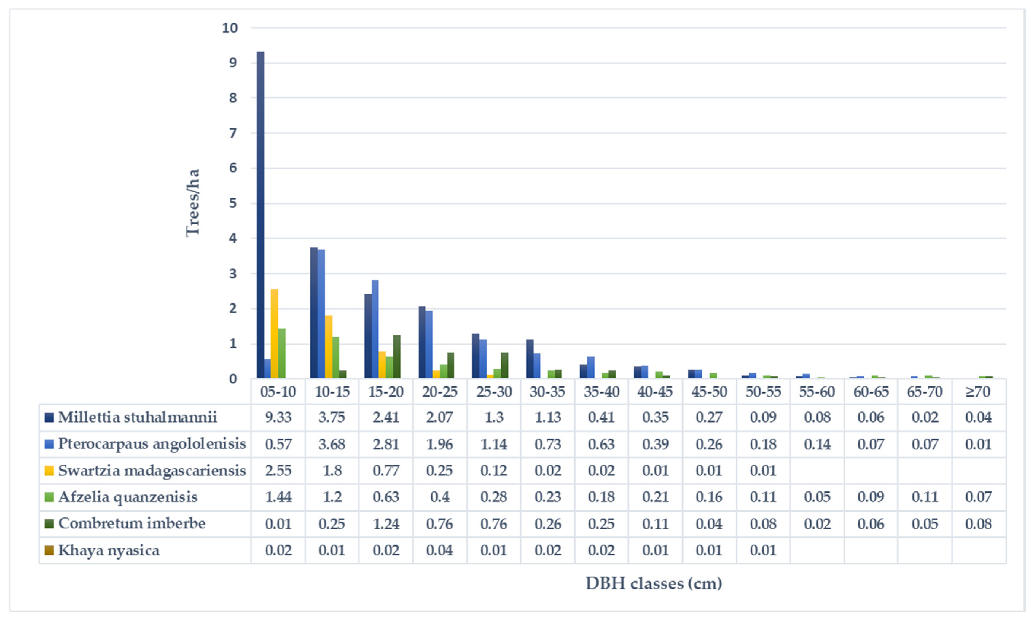
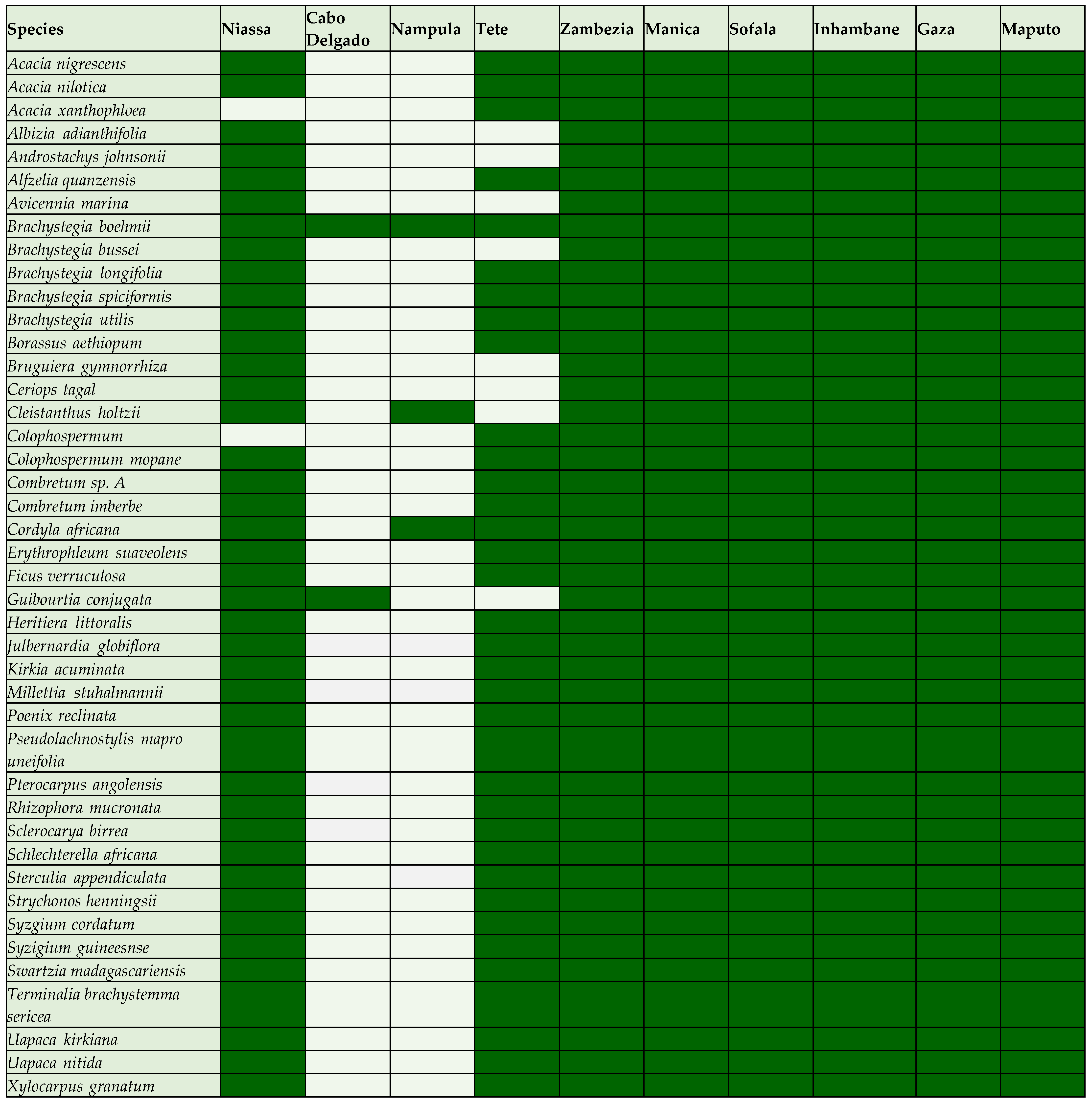
2.4. Forest Composition

In Mozambique, it is estimated that there are 449 types of tree and shrub species, with the highest number of trees per hectare and the largest basal area in the mecrusse forest [5]. Table 2 presents a list of the main species in Mozambique, with the most valuable value according to national and international markets, indicating the scientific names and the common name adopted locally. The “NI” stands for “No Information”.
The species distribute over a large area of forest in Mozambique. Figure 4 shows the actual distribution of forest species by province.
The data on tree species distribution in Figure 4 was based on the NFI results [5] and was updated by consulting the Flora de Mozambique database. According to this database, Mozambique is divided into six large regions, as in the Flora Zambesiaca, providing no discriminated information for Cabo Delgado and Nampula, only for Niassa. As a result, it is assumed that the species identified in the column corresponding to Niassa may also be present in these regions (e.g., Acacia nigrescens, A. nilotica, Ceriops tagal, Avicenia marina, and Albizia adianthifolia are very common in Cabo Delgado).

2.5. Threats and Disturbances Impacting Forests

According to the Intergovernmental Panel on Climate Change (IPCC), many Africans live in areas prone to drought, floods, food insecurity and the emergence of chronic diseases. Climate threats have affected the African continent in the last decade. In the case of Mozambique in particular, these phenomena are notorious and include several cyclones, floods, and droughts.
Projections of climate change and its impacts on ecosystems in general and forests in particular give a bleak picture given the dependence of most of the rural population (85%) and the current rates (5.6%) of deforestation, land use conversion, and uncontrolled bushfires [8]. The main threats to the forest in Mozambique will be identified and characterized in the following subsections. The databases for Mozambique’s FAO, FRA, and NFI [5] do not contain information about insect or disease outbreaks or severe weather events that could help measure the extent of their impact on forests.

2.5.1. Floods

Mozambique, as part of the Indian Ocean channel, is susceptible to tropical cyclones, which occur frequently and have damaging effects. The floods cause damage of various kinds, causing people to move from one place to another, creating dispersion situations as people must abandon their homes and farms in search of a safe place. The floods cause a delay in the development of the country, mainly in the loss of crops, various heavy losses in agriculture, forestry, and education, loss of pasture for grazing, as well as damage to infrastructure, leading the country to a state of emergency. Mangroves are one of the main types of coastal habitats present in the Northern Mozambique Channel region that provide significant coastal protection against storms, floods, and giant waves [9]. Mangrove cover was reduced by 48% in Mozambique in 2000 by tropical cyclone Eline, with 100% of the mortality of seaward mangroves dominated by Rhizophora mucronata [10]. Recovery of mangrove species was observed 14 years later in sheltered sites. According to these authors, frequent and intense cyclones can change the structure of a mangrove forest, and sea-exposed forests are more vulnerable than creek and inner forests. The forest condition plays an important role in the ability of impacted forests to recover after such disturbance. Although there is low confidence, these cyclone-induced impacts are attributable to climate change owing in part to a lack of reliable long-term data sets [10]; climate change may be compromising these ecosystem services according to the IPCC [11].
Water-related climate risks have been addressed through an increasing number of ecosystem-based adaptation projects involving the restoration of mangrove, wetland, and riparian ecosystems in Beira, Mozambique by mitigating increased flood risks through the restoration of mangrove and other natural habitats along the Chiveve river and the development of urban green spaces (refs: [12,13]) or Maputo through the restoration of mangrove and riparian ecosystems for flood control and protection from coastal-flooding-enhanced water supply [14].
The government has created several actions to minimize the phenomenon and the impacts of floods. They are currently implementing some programs funded by cooperation partners to support the populations in areas at risk of flooding. This work is fragile due to populations’ resistance to leaving their home areas. The provinces most affected by floods are the southern provinces of Maputo, Gaza, and Inhambane; the central provinces of Sofala, Zambezi, and Tete; and the northern province of Nampula [2]. It should be noted that floods threaten forest biomes, the growth of young trees, and new plantations. Many of the Mozambican populations are dependent on the forest; they rely on it for their sustenance. The force of the water ends up uprooting young trees, and many of them end up dying from excess water, causing the loss of forest cover.

2.5.2. Drought and Desertification

Drought is a naturally occurring phenomenon that occurs when the recorded rainfall is significantly lower than normal values, causing a severe water imbalance that negatively affects production systems dependent on land resources [2]. In particular, Mozambique has suffered from drought in some parts of the country due to two main factors of natural and anthropogenic origin. These are natural phenomena of meteorological origin, not controllable by man, which can cause drought in certain regions. In Mozambique, most of the agriculture performed with arable crops is rainfed; that is, the water needed for the plant’s life cycle comes exclusively from precipitation [4].
People in constant change, in the search for improving quality of life, create situations that threaten forests. Prolonged droughts, along with human activities such as excessive use of soil resources, uncontrolled burning, deforestation, the excessive use of toxic agro, and inappropriate agricultural practices, can all contribute to soil desertification. The provinces of Inhambane and Gaza are particularly affected by the drought problem in Mozambique. This phenomenon causes the population to be at the extreme limit of poverty, without food and drinkable water and with children in a situation of malnutrition due to the lack of minimum conditions for survival. Many populations leave their areas of origin for better living conditions, seeking new fertile land for agricultural production.

2.5.3. Plagues and Diseases

“Disease is a dynamic process in which pathogen and host, in an intimate relationship with the environment, influence each other, from which morphological and physiological modifications in the plant result” [15]. A plant can contract several types of diseases due to various factors, some interrelated. Among the biotic diseases are parasites, pathogens, and the ability of the parasite to interfere with the plant’s normal functions and cause disease [15].
Protecting forest areas against pests and diseases aims to prevent or reduce damage and consequent loss in income to increase the production of timber and non-timber forest products [7]. The introduction or outbreak of pests and diseases in miombo trees can cause damage to the trees and result in reduced potential revenue due to losses or in preventing investment from being made.
Several diseases have devastated the forests as well as the crops. In Mozambique, pests are present in various crops, and the most frequent pests are the funnel worm, lethal yellowing, Panama disease; mining caterpillars, and locusts. These pests have created triggers for a low level of production. Without frequent monitoring and assistance, the trees eventually decline and die. Prevention plays a key role in reducing impacts, so the forest should be monitored regularly.
Mozambique is struggling at all costs to overcome forest and crop pests, and the government has a contingency plan to avoid a catastrophe. Most of the campaigns are more related to crops, and regarding trees, the practice of pruning and spraying to fight pests is well known. The most common species in these campaigns are cashew, coconut, mango, massanqueira, orange, avocado, and lemon trees. There are also references to some existing measures against pests and diseases, which include local traditional cultural control practices, such as pruning, cleaning the forest floor, and farm destruction [7]. In some concession nurseries, registered pesticides have been applied to combat pests and diseases—for example, fungicides in nurseries to combat rusts and correction of soil nutrient deficiency in nurseries through appropriate fertilizers [7].

2.5.4. Fire

The vegetation cover of the Earth’s surface has been undergoing profound changes due to human actions associated with uncontrolled burning and its natural causes [16]. According to [17], 90% of forest fires are caused by humans, 5% have natural causes, and another 5% are of unknown origin.
Forest fires have terrible environmental, social, and economic consequences [17], including increasing air pollution (Renato, S/D). The consequences and negative impacts of uncontrolled burning are of national and international concern because they are not only sources of greenhouse gas emissions that contribute to climate threats but also sources of natural resource degradation [17]. The climate is related to forest fires in two ways: it determines the duration and severity of the fire since vegetation largely depends on climatic conditions, and it also determines the amount of available fuel [16].
The leading causes that contribute to the occurrence of forest fires in Mozambique are associated with poverty (strong dependence of the population on forest resources) and the high rate of illiteracy [16]. The unbridled use of fire has caused considerable losses to forest cultivation projects in northern Mozambique [16]. Between 2000 and 2016, Mozambique experienced significant forest fires, affecting up to 18,713,790 hectares of land in 2010. The majority of these fires, over 90%, occurred within forested areas. According to the same source, the forest area affected by fires specifically ranged from a minimum of 6,647,950 to 17,386,440 hectares during this period.

2.5.5. Anthropogenic Factors

Human actions translate into anthropogenic factors that can create problems for the environment. In Section 2.5.2, the authors highlighted some of these factors. Population demand for fields for housing as well as agricultural fields, pastures, and natural resource uses are the main threats to forests in Mozambique. The most frequent human actions that cause climate threats are the burning of forests and the degradation of soils, which emit gases that increase the greenhouse effect. Considering only the anthropogenic causes, and according to [8], these are the emission of GHG by humans. The correct measures to be taken focus essentially on the need to invest in renewable energy sources (wind, sun, waves) and the transition to a low-carbon economy [8].
Given these threats, forest systems may be a solution. While forest systems do not offer a solution for everything, to secure or stabilize their well-being, people experiencing poverty have been able to harness forest goods and services to manage and mitigate risk, mainly where market access and public service provision are limited [18]. However, the unbridled search for raw materials for the country’s development leads to the massive exploitation of natural resources. Various types of forests suffer from human activity, but mangroves are particularly vulnerable and prone to degradation. In Mozambique, the causes of mangrove degradation are linked to anthropogenic and natural factors, largely related to the main forms of use of mangrove resources [19]. Among the forms of use of mangroves are extraction of woody fuel, the cutting of trees for the construction of houses and boats, and the construction of salt pans (refs. [20,21]). The population preferentially uses mangrove species such as Avicennia marina, Ceriops tagal, and Sonneratia alba in most of its activities, applying them in the construction of houses, furniture production, boat building, and the production of firewood and charcoal [22]. Mangroves also face severe challenges due to pressures for conversion into other land uses (e.g., agriculture, aquaculture, and urban). Forest degradation and logging negatively affect the ecosystem services provided by this ecosystem [23]. In Mozambique, widespread losses of mangrove cover have been reported between 1972 and 2002 for the Zambezia province (about 745 km2 lost over the thirty-year period) [24].
Mozambique is one of several countries on the African continent that have a high rate of forest exploitation, with wood being the most exploited resource. In recent decades, the entry of foreigners into the country in search of forest resources has raised several discussions around the supervision and laws regarding the safeguarding of the forest. Two modalities are applicable in forest exploration, the first with a simple license and the second with a forest concession. Forest exploitation under a simple license is discriminatory to foreigners, applicable only to national individuals or legal entities, and limited to an annual cutting volume of 500 m3 [25]. The exploitation under the forest concession regime is destined to supply the industry and is allowed to any national or foreign natural or legal person with the following requirements: (i) have a management plan available and approved by the department; (ii) guarantee the processing of logs, including those purchased from third parties; (iii) declare that they will only export up to a maximum of 40% of the wood logs per year; (iv) request the reduction of the exploitation tax for logs destined for local processing [25]. As timber plays a crucial role in the lives of Mozambicans since they build their houses with wood, it is also commercialized informally. This form can have a negative impact when engaged in without precaution or regulation, such as burning forests to obtain a field for cultivation or to scare off some animals. It is also known that women in rural Mozambique look to the forests for energy because it is from the Mozambican forests that many families use the charcoal from firewood to cook food.

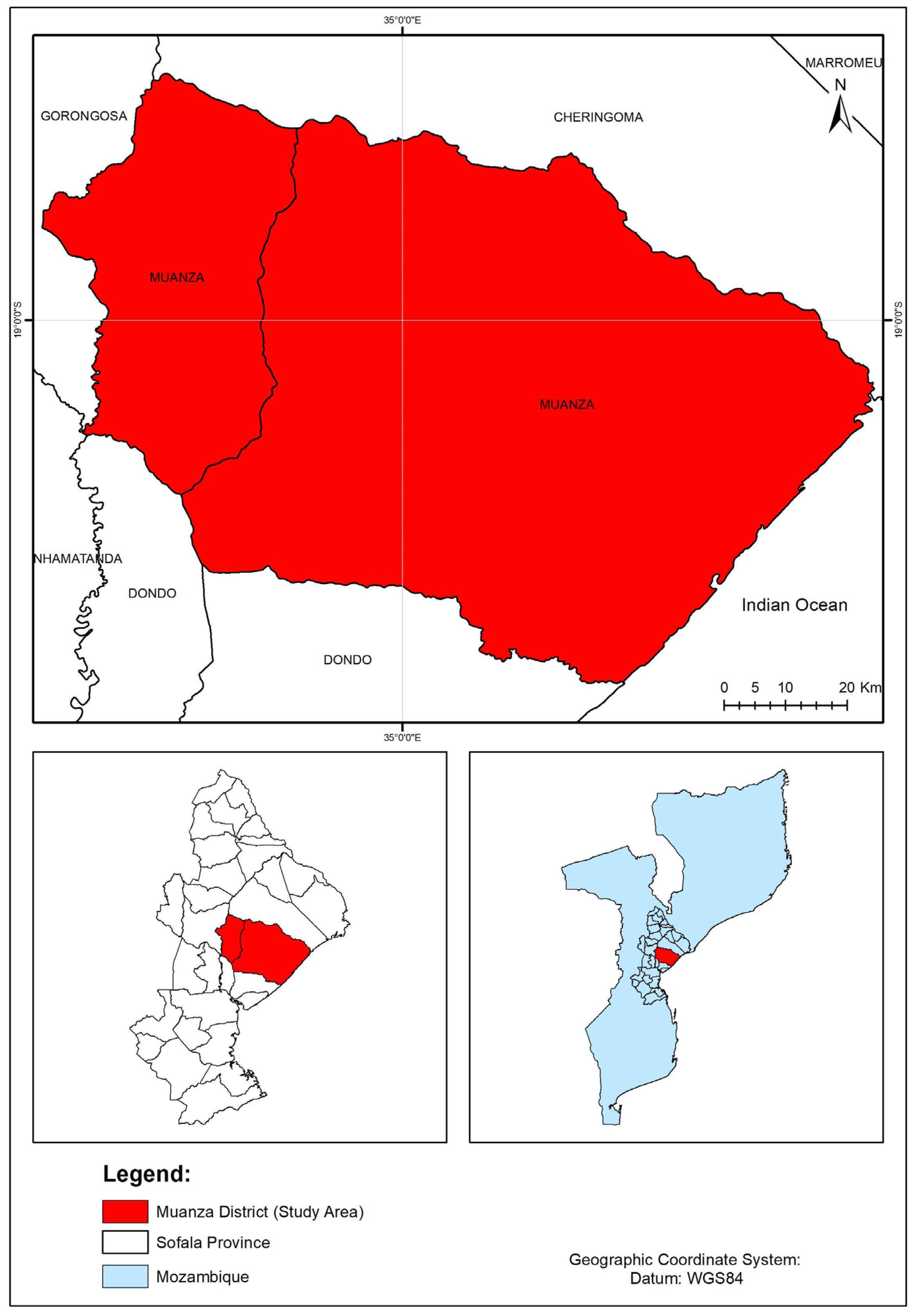
3. The Case of Study of the Muanza District

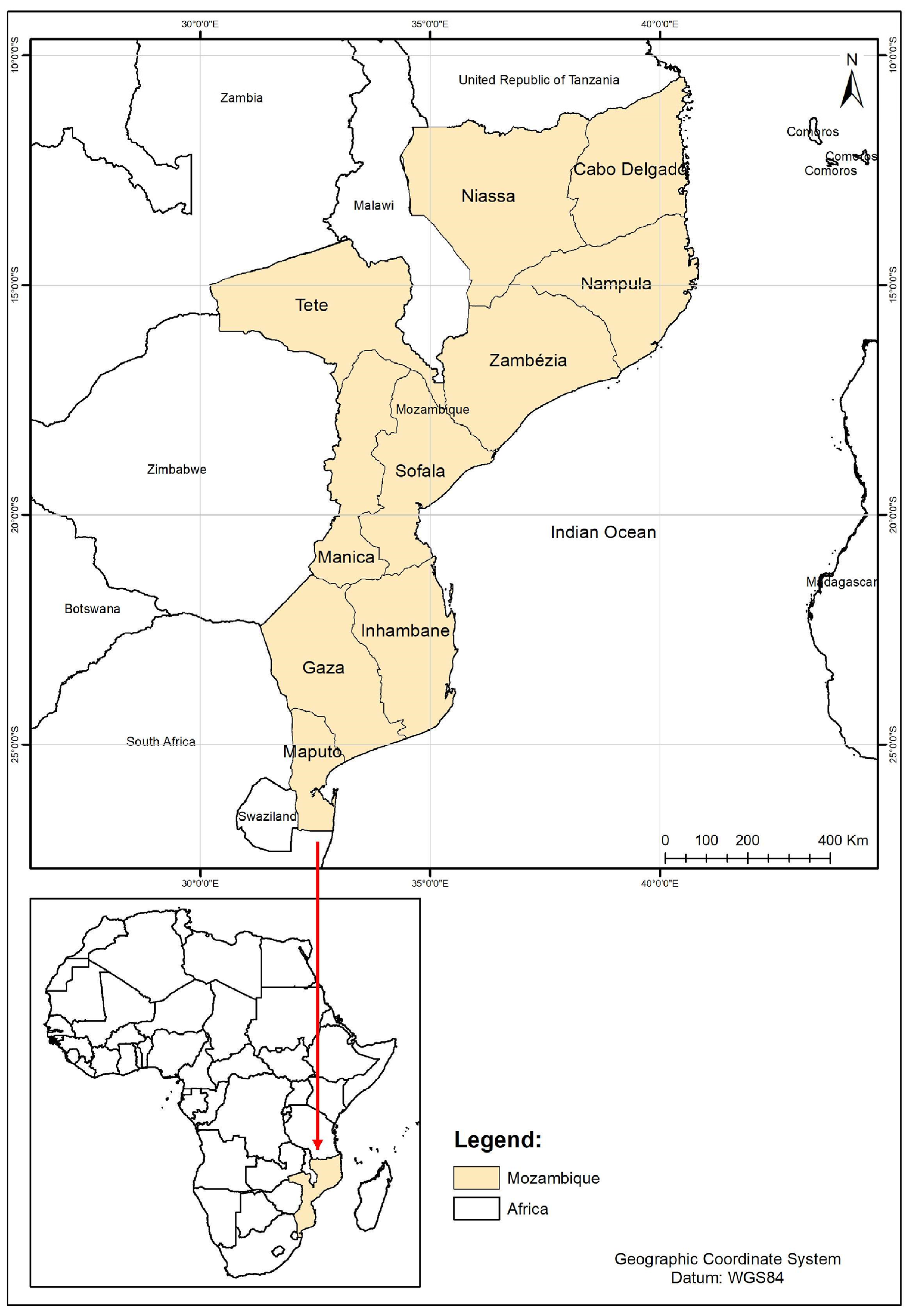
3.1. Characterization of the Study Area

The district of Muanza is located in Sofala Province and has a total area of 7,513 km2. It is bounded to the north by Chiringoma District, to the south/southwest by Dondo and Namatanda Districts, to the east by the Indian Ocean, and to the west by Gorongosa District [26]. Muanza is bounded by the following geographical coordinates: 180 39′ 13″ to 190 07′ 00″ south latitude and 340 29′ 36′ and 350 12′ 00′ east longitude [27]. The district of Maunza is part of the buffer zone of the Gorongosa national park. It has floristic potential at the level of Sofala province [26].
The combination and correlation of the different natural physical elements—with greater emphasis on the geology, geomorphology, climate, and hydrography—with frequent occurrence in the district of Muanza, Sofala Province, Mozambique results basically in alluvial soils, poorly evolved litholics, and vertisols of limestone origin [27].
In terms of precipitation and temperature in the district of Muanza compared to the district of Beira, the monthly average precipitation presents a relevant seasonal variation that stands out: a wet period occurs between November and April, in which a precipitation value equivalent to 84% of the total annual precipitation value occurs, with January being the rainiest month, with an average monthly precipitation of about 265 mm. A dry period between with monthly precipitation averages of less than 35 mm occurs between June and October [26]. The average annual temperature is 24.7 °C, with a relatively low annual temperature range of about 3.6 °C. February is the hottest month (27.8 °C), and July is the coldest (20.6 °C) [3]. According to the Koppen classification, the district is influenced by the tropical rainy savanna (Aw)-type climate. In the coastal strip, the average rainfall is above 800mm, reaching, in most cases, 1200 mm or even 1400 mm [28].
Statistically, Sofala Province is prone to the occurrence of cyclones, with the district of Muanza classified as having a risk of being hit by a cyclone. In the 1940s and in later decades, it was hit by cyclones—Berobia in 1986, Bonita in 1995, Lisette in 1997, and A19798 in 1998 [26]. However, in recent years, Muanza District has suffered from cyclones that affect almost all of the country. The most critical cyclone was Idai in 2019, with others passing later, like Chanale and Eloise in 2020 [29].
In the Muanza District, mananga soils predominate (37% of the total area of the district). The soil is made up of different soil associations (M, MA, MM, PA, and PM), followed by soils on limestone (about 27%) and sandy soils (19%). Alluvial soils (15%) and estuarine marine sediments (1%) make up the remaining typology [3].
Muanza is bordered to the north by the district of Cheringoma, to the east by the Indian Ocean, to the south by the district of Dondo, to the northwest by the district of Nhamatanda, and finally to the west by the district of Gorongosa (Figure 5). The district has two administrative posts, namely Muanza and Galinha. It also has four localities: Vila de Sede, Muanza, Galinha Sede, and Wiriquise. According to INE results of the 2017 census, the district of Muanza has about 39,260 people, with a density of 5.2 inhabitants/km2.
It is an area with high economic expression and management of natural resources; 2/3 of the Gorongosa National Park-PNG are in the territory of Muanza, including the Mueredzi River and the Goronga Mission. The suitability of the soils in the coastal strip and the Rift Valley, the existence of rivers and streams that conserve water throughout the year, the limestone as the only mineral resource in exploitation, and the coast and the waters of Lake Urema favor the practice of tourism [26].
The district consists of three administrative posts: Muanza-Sede, Galinha, and Chenapamimba. It has eight localities: Muanza-Sede, Pedreira, Galinha-Sede, Honve, Nhansato, Chenapamimba-Sede, Wirquinze, and Nhamassinzira. The composition of the council is according to the administrative division [27].

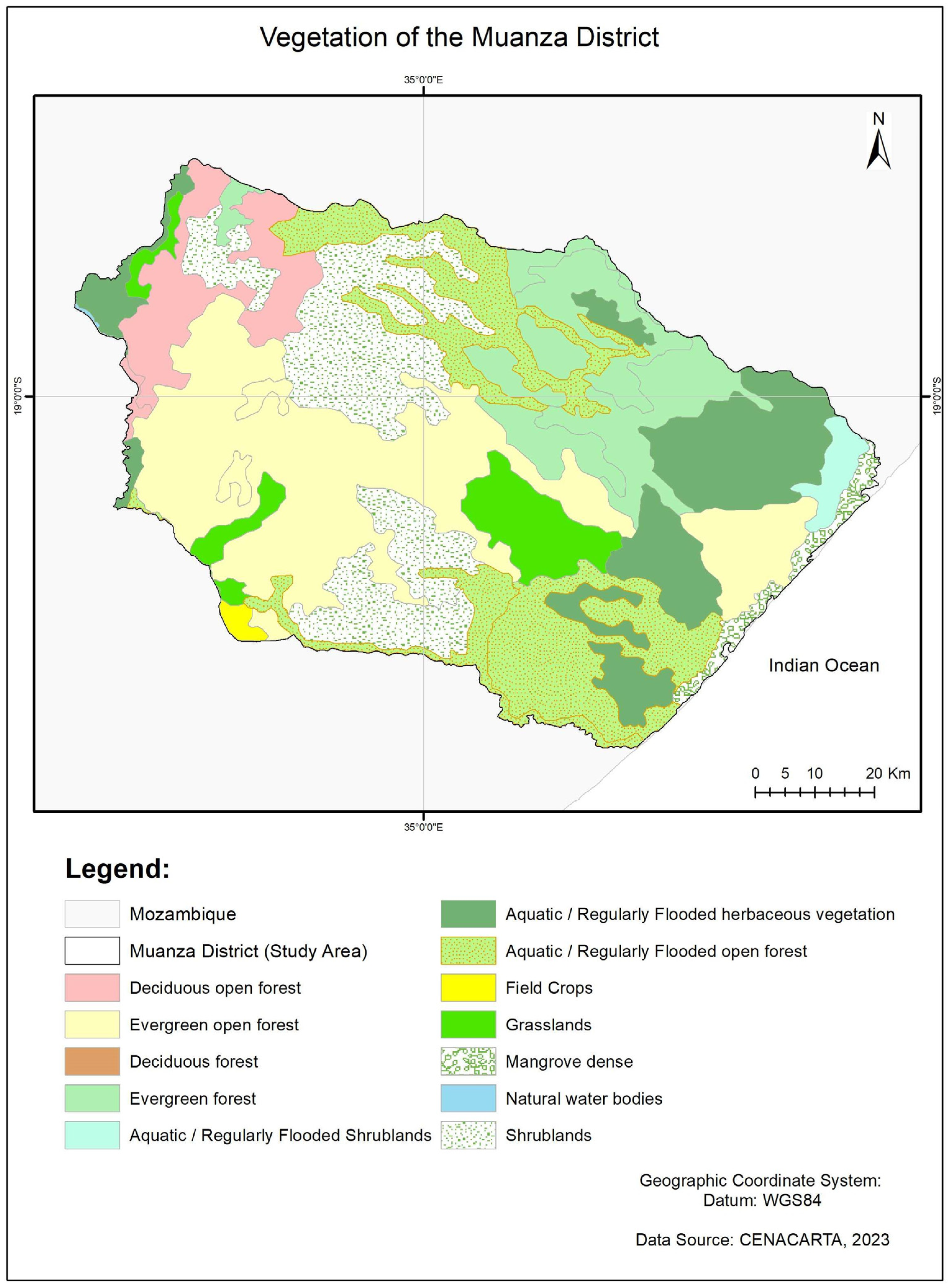
3.2. Actual Forest Resources

The district of Muanza has remarkable forest cover distributed uniformly in space; this situation is due to the specific natural conditions of the relief, soils, and climate [28]. In general, the vegetation in the district is dominated by lowland open and closed forest species and other formations as follows: lowland open forest formation; wooded herbaceous; open scrubland; mangrove (locally degraded and lowland closed forest) [28]. Regarding the classification of major forest types (see Figure 6), the primary strata include evergreen open forest, regularly flooded open forest, evergreen forest, deciduous open forest, and mangrove.
The forest resources in the district of Muanza are mangroves located on the district’s coast. Regarding the number of mangrove species, there is a relative reduction in this area due to the peculiarities of the natural physical conditions to which they are subjected regarding the renewal and diversity of the species. Among the existing species in the area, Ceriops tagal, Rhizophora mucronata, Avicennia marina, Xylocarpus granatum, Bruguiera gymnorriza, and Heritiera litoralis predominate [27]. Some species along the coast of Muanza are being exploited in an unbridled manner. This vegetation covers almost the entire length of the ocean coast of the Muanza district, with an average width equivalent to 300 m, and is composed of trees and shrubs with heights ranging from 1 to 4 m; this vegetation is always green due to the high level of humidity of the soil [27].
Mangroves are rich in protein and serve as a habitat for marine fauna. Some of these species of mangroves are seen with potential for various purposes. According to [27], reasons for the destruction of different species of mangroves include exploitation for the construction of precarious housing and barns, firewood for domestic use, the manufacture of salt from the technique of boiling, poles for drying fish, bark for dyeing hammocks, medicines, and other purposes.
Mangal forest is a sensitive and critical ecosystem with numerous functions for direct and indirect use. Pressure from human activities, such as urban sprawl; demand for firewood, charcoal, and pilings; and contamination of estuaries by liquid waste, among other activities, has been identified as the greatest threat to Mozambique’s mangroves [19].
Regarding the savannah forest of the Muanza district, Ref. [30] says that savannah is characterized by vegetation found in tropical or subtropical regions that are under a long period of drought that receive more rainfall than desert regions and physiognomically present sparse trees and shrubs or scattered groups of trees and shrubs in a very pronounced graminoid. The main ecological determinants of savannas are water and nutrient availability as the primary control; fire, herbivory, and human intervention are the environmental modifiers [30]. The calculation made in the Muanza District reveals that the savannah occupies more than 40% of the district’s total area, estimated at 7515 km2 [27].
The district of Muanza has the miombo forest, which is used for various purposes. Miombo is a term used to describe the forest areas of Africa’s central, southern, and eastern regions with a predominance of the genera Brachaystegia, Jubernardia, and/or Isoberlina, all from the family Fabaceae and subfamily Caesalpinoideae [6].
In Muanza, this vegetation occupies the entire central zone, the medio central plateau, continuously and is characterized by the predominance of the tree species Brachystegia longifolia [27]. Muanza has natural forests over 498,453 hectares with various species, especially missassa, missanda, panga-panga, chanfuta, umbila, monzo, mipepe, and muimbe, and an average annual production of about 5,381,462.6 m3 [28].
The species found in the Muanza district are listed in Table 3 by forest type.
According to documents concerning the district, mangroves are in decline or threatened with extinction. These species have a high rate of exploitation because they are easy to cut and because they are in an isolated area. In remote and low-population-density areas in which domestic consumption of timber resources is the predominant form of use, impacts may be less pronounced [19]. Anthropogenic factors seem to constitute the main threat to mangroves in the country and are related to a large extent to the main forms of use of mangrove resources [19].
The most endangered species besides mangroves are all being exploited irrationally. Timber companies have preferences for some species, particularly Millettia stuhlmannii (panga-panga), Afzelia quanzensis (chanfuta), and Pterocarpus angolennsis (umbila), which have great value at the national and international levels. It is premature to mention at this point which species are favored, as documents are needed to support the question, but some documents show that fruit trees are less exploited. In places where the forest is cut down and replaced by subsistence agriculture, only fruit trees are maintained, such as Sclerocary birrea (canhoeiro), Striychnos spinosa (massala), Garcinia livingstonei (imbebe), and Mangifera indica (mango) among other species [27]. In general, the other forest species require further investigation regarding the species’ decline since no forest inventory addresses the decline in the district of Muanza.

3.3. Main Threats in the Period from 2015 to 2020

In the period from 2015 to 2022, the forests of Muanza suffered major threats, first due to anthropogenic factors and second due to climatic threats. The anthropogenic factor is associated with several factors; firstly, the poverty level of some families whose income comes from the forest. The search for a field to cultivate crops has often caused people to set fires to clear the forest, creating conditions for uncontrolled burning.
Another anthropogenic factor is insufficient schooling and lack of knowledge of caring for the forest to protect the environment. The unbridled search for wood for construction and charcoal production led to the massive cutting down of trees for personal consumption.
The district has had considerable forest loss due to uncontrolled burning in the last five years, which has led the local authorities to take measures to safeguard the lives of the population and the forests. One of the actions was to train some community leaders to spread information regarding the consequences of setting fire to the forest. There was also the need to train some forest guards to be more vigilant regarding the population’s actions towards the forest. In addition to these actions in the district of Muanza in this period of 5 years, there was also an action plan created by the government of Mozambique to address the problem of burning, which resulted in the improvement of the law that protects the forest. This law took the form of a document presented as the Action Plan for Prevention and Control of Uncontrolled Burning In Mozambique, which was based on the analysis of the current scenario in terms of causative factors, solutions for prevention and control, and the proposal of measures or procedures to find sustainable ways to mitigate the problem [5].
Exploitation is also observed under concessions or by the license granted by the government; other exploitation occurs in a clandestine manner. Forest exploitation under a forest concession contract has higher costs and obligations than simple licenses because forest concessions require forest inventories, detailed management plans, and social, ecological, and environmental obligations, increasing costs [31]. Consequently, many entrepreneurs prefer to apply for simple licenses, which do not demand many costs and requirements despite competing with concessions for the same forests. The consequence is the degradation of forests and the environment and the marginalization of local communities since simple licenses do not have social, ecological, or environmental obligations [31].
Regarding the application of good forestry practices, Mozambique’s law represents a significant advance in including local communities in managing forest resources compared to other countries [32]. If well implemented, this legislation could allow a series of very important community benefits, improving their socio-economic conditions and minimizing possible conflicts that appear when forest concessions are carried out in inhabited areas [32].
Regarding climate threats from to the district of Muanza from 2015 to 2020, it was also affected by storms in Mozambique. Uncontrolled logging also accentuates climate problems since the lack of trees leads to climate problems. Climate change is a global problem with different impacts depending on the region of the planet. It requires concerted and complementary actions between local, national, and international levels for mitigation and adaptation [8].
Forests contribute to environmental stability, for example, via the mitigation of extreme temperatures, increasing regional precipitation and preventing soil erosion and deterioration, and play a fundamental role in the carbon cycle; they are the largest carbon sink of all terrestrial ecosystems and function in many cases as sinks [33].
A part of the Muanza district belongs to the coastline, so it is necessary to adopt some strategies for stormy situations, such as floods and cyclones. It is vital that the government be aware of these situations and act immediately to incorporate the risks of climate change into its planning and investment in infrastructure and establish a national climate change response plan [34].

4. Conclusions

This study gathered information from various sources, some of which were challenging to obtain as they were in the national language, to provide insight into the state of Africa’s forests in general and Mozambique in particular. According to [1], in Africa in the most recent five-year period (2015–2020), the annual deforestation rate was estimated at 10 million ha, down from 12 ha in (2010–2015). About 98 million ha of forests were affected by fire in 2015, mainly in the tropical domain, where fire burned about 4% of the total forest area that year [1].
In Mozambique, there are several types of forests, namely miombo, mecrusse, and mapone, with a large diversity of tree species. These forests have suffered loss because of two factors. The first has to do with anthropological factors and other climate threats. Climate threats have also impacted African forests. In recent years, several regions of Mozambique have lost forests due to severe weather conditions and have also created large-scale flooding, which has led Mozambique to declare humanitarian aid. With the rapid growth of the country and the search for land to produce crops becoming indispensable for the population, this has caused the exploitation of forest resources. Consequently, problems resulted from the massive exploitation of forest resources to create agricultural fields, creating the possibility for uncontrolled burning, deforestation, and forest desertification.

Author Contributions

Conceptualization, E.J.-M., T.F.F., J.L. and M.L.R.L.; methodology, E.J.-M.; formal analysis, E.J.-M.; investigation, E.J.-M.; writing—original draft preparation, E.J.-M. and T.F.F.; writing—review and editing, E.J.-M., T.F.F., J.L. and M.L.R.L.; supervision, T.F.F., J.L. and M.L.R.L. All authors have read and agreed to the published version of the manuscript.

Funding

This research was partially supported by national funds provided by the FCT (“Foundation for Science and Technology/Ministry of Science, Technology and Higher Education”) to the CEF research unit (UIDB/00239/2020) and to CITAB (UIDB/04033/2020).

Institutional Review Board Statement

Not applicable.

Informed Consent Statement

Not applicable.

Data Availability Statement

No new data were created.

Acknowledgments

The first author would like to express special thanks go to her family; to the José Lousada, Margarida Liberato, and Teresa Fonseca, who participated directly in the preparation of this article; and to Luis Deixa and Eng Ernestro Uetimane for the documents in the area forest area. The authors would like to thank the two anonymous reviewers for providing valuable comments, which contributed to improving the manuscript.

Conflicts of Interest

The authors declare no conflict of interest.

References

  1. FAO. Global Forest Resources Assessments; FAO: Rome, Italy, 2020. [Google Scholar] [CrossRef]
  2. Ministry for the Coordination of Environmental Action. Plano de Acção Nacional de Combate à Seca e à Desertificação; Ministry for the Coordination of Environmental Action: Maputo, Mozambique, 2005; 39p.
  3. Gaspar, M.C.; Cossa, H.A.; Santos, C.R.; Manjate, R.M.; Schoemaker, J. Moçambique, Inquérito Demográfico e de Saúde, 1997; Instituto Nacional de Estatística e Macro International Inc.: Calverton, MD, USA, 1998; 215p, Available online: https://www.afro.who.int/sites/default/files/2017-07/moz-IDS-1997.pdf (accessed on 14 August 2022).
  4. Mo, B.D.E. Plano Director para Prevenção e Mitigação das Calamidades Naturais. Instituto Nacional de Gestão e Calamidade: Maputo, Mozambique, 2017; 36p. [Google Scholar]
  5. Ministry of Land, Environment and Rural Development. National Forest Inventory Report; Ministry of Land, Environment and Rural Development: Maputo, Mozambique, 2018; pp. 41–180.
  6. Bila, J.M.; Sanquetta, C.R.; Corte, A.P.D.; De Freitas, L.J.M. Diametric distribution and main tree species present in the Miombo, Mopane and Mecrusse ecosystems in Mozambique. Braz. For. Res. 2018, 38, e201701523. [Google Scholar] [CrossRef]
  7. Ribeiro, N.; Bandeira, R.R.; Darabant, A. FAO Technical and Strategic Support to the Implementation of the Mozambique Forest Investment Program (MOZFIP), Component 2: Development of the methodology for integrated forest management planning—Treinamento; Protecçãao contra pragas e doenças em florestas: Mocuba, Moçambique, 2021; 18p. Available online: http://www.dinaf.gov.mz/wp-content/uploads/2021/12/MOZFIP-FAO_DINAF-Proteccao-Pestes-e-Doencas_101121-min.pdf (accessed on 12 January 2023).
  8. Isabel, A.; Ramos, M.C.P. Climate Change and Its Consequences: Forced Population Displacement. The Overarching Issues of the European Space: Rethinking Socioeconomic and Environmental Problems; de Letras da Universidade do Porto: Porto, Portugal, 2016; pp. 203–219. [Google Scholar]
  9. Ghermandi, A.; Obura, D.; Knudsen, C.; Nunes, P.A.L.D. Marine eco-system services in the Northern Mozambique Channel: A geospatial and so-cio-economic analysis for policy support. Ecosyst. Serv. 2019, 35, 1–12. [Google Scholar] [CrossRef]
  10. Macamo, C.C.F.; Massuanganhe, E.; Nicolau, D.K.; Bandeira, S.O.; Adams, J.B. Mangrove’s response to cyclone Eline (2000): What is happening 14 years later. Aquat. Bot. 2016, 134, 10–17. [Google Scholar] [CrossRef]
  11. Trisos, C.H.; Adelekan, I.O.; Totin, E.; Ayanlade, A.; Efitre, J.; Gemeda, A.; Kalaba, K.; Lennard, C.; Masao, C.; Mgaya, Y.; et al. Climate Change 2022: Impacts, Adaptation and Vulnerability. Contribution of Working Group II to the Sixth Assessment Report of the Intergovernmental Panel on Climate Change; Pörtner, H., Roberts, D., Tignor, M., Poloczanska, E., Mintenbeck, K., Alegría, A., Craig, M., Langsdorf, S., Löschke, S., Möller, V., et al., Eds.; Cambridge University Press: Cambridge, UK; New York, NY, USA, 2022; pp. 1285–1455. [Google Scholar] [CrossRef]
  12. IPCC. Climate Change and Land: An IPCC Special Report on Climate Change, Desertification, Land Degradation, Sustainable Land Management, Food Security, and Greenhouse Gas Fluxes in Terrestrial Ecosystems; Skea, J., Buendia, E.C., Masson-Delmotte, V., Pörtner, H., Roberts, D., Zhai, P., Slade, R., Connors, S., van Diemen, M.R., Ferrat, E., et al., Eds.; IPCC: Geneva, Switzerland, 2019; Available online: https://www.ipcc.ch/srccl-report-download-page/ (accessed on 20 September 2022).
  13. CES Consulting Engineers Salzgitter GmbH; Inros Lackner SE. Upscaling Nature-Based Flood Protection in Mozambique’s Cities; Zangerling, B.M., Jongman, B., Matera, M., Carrera, L., Chavana, X., Carrion, S., Midgley, A., Erman, A., Zanten, B., Ledden, M.V., Eds.; World Bank Group: Washington, DC, USA, 2020; 45p, Available online: https://documents1.worldbank.org/curated/en/401611585291379085/pdf/Upscaling-Nature-Based-Flood-Protection-in-Mozambique-s-Cities-Knowledge-Note.pdf (accessed on 28 September 2022).
  14. GEF. Mozambique: Building Resilience in the Coastal Zone through Ecosystem Based Approaches to Adaptation (EbA); Global Environment Facility: Washington, DC, USA, 2019; 2p, Available online: https://www.thegef.org/project/mozambique-building-resilience-coastal-zone-through-ecosystem-basedapproaches-adaptation (accessed on 16 July 2022).
  15. Camargo, M. Concept and Classification of Plant Diseases. 2015. Available online: https://www.fcav.unesp.br/Home/departamentos/fitossanidade/MARGARETECAMARGO/conceito-e-classificacao2015pdf.pdf (accessed on 18 August 2022).
  16. Mbanze, A. Analysis of Fire Occurrences in Forest Stands of the Company Chikweti Forest of Niassa in Northern Mozambique; Universidade Federal do Paraná: Curitiba, Brazil, 2013; 83p. [Google Scholar]
  17. Matimbe, D.O. Community Participation in the Management of Uncontrolled Burning in Mapinhane Administrative Post - Vilankulo District; Superior School of Rural Development (ESUDER): Vilankulo, Mozambique, 2015. [Google Scholar]
  18. Ihalainen, M.; Jagger, P.A.; Kabwe, G.; Kamoto, J.; Miller, D.C.; Mutta, D.N.; Rasmussen, L.V.; Joleen, T. Florestas, Arvores e o Alivio da Pobreza na Africa: Resumo Expandido de Politicas. Forests, Trees and Poverty Alleviation in Africa: An Expanded Policy Brief; Miller, D.C., Mansourian, S., Wildburger, C., Eds.; Global Forest Expert Panels (GFEP) Programme International Union of Forest Research Organizations (IUFRO): Neulengbach, Austria, 2021; Available online: https://euagenda.eu/upload/publications/gfep-forests-trees-and-poverty-alleviation-africa-policy-brief-portuguese.pdf (accessed on 18 August 2022).
  19. Macamo, C.D. Sitoe, The Environmental Governance Report 2016—Governance and Management of Mangroves in Mozambique; Centro Terra Viva: Maputo, Mozambique, 2017; p. 63. [Google Scholar]
  20. Barbosa, F.M.A.; Cuambe, C.C.; Bandeira, S.O. Status and distribution of mangroves in Mozambique. South Afr. J. Bot. 2001, 67, 393–398. [Google Scholar] [CrossRef] [Green Version]
  21. Ribeiro, N.; Sitoe, A.A.; Guedes, B.S.; Staiss, C. Manual de Silvicultura Tropical. Rev. Inst. Med. Trop. S 2002, 1, 130. Available online: https://www.bibliotecaagptea.org.br/agricultura/silvicultura/livros/MANUAL%20DE%20SILVICULTURA%20TROPICAL.pdf (accessed on 10 May 2023).
  22. Lacerda, A.; Andrade, A.C. Análise das atividades antrópicas nas florestas de mangal em Macuse, centro de Moçambique. Nat. Resour. 2022, 12, 159–169. [Google Scholar] [CrossRef]
  23. Giri, C.; Muhlhausen, J. Mangrove forest distribution and dynamics in Madagascar. Sensors 2008, 8, 2104–2117. [Google Scholar] [CrossRef] [PubMed] [Green Version]
  24. Fatoyinbo, T.E.; Simard, M.; Washington-Allen, R.A.; Shugart, H.H. Landscape-scale extent, height, biomass, and carbon estimation of Mozambique’s mangrove forests with Landsat ETM+ and Shuttle Radar Topography Mission elevation data. J. Geophys. Res. 2008, 113, G02S06. [Google Scholar] [CrossRef]
  25. Chitará, S. Indústria Florestal Moçambicana Moçambicana; Direcção Nacional de Florestas e Fauna Bravia: Maputo, Moçambique, 2003; 58p, Available online: https://www.iied.org/sites/default/files/pdfs/migrate/13517IIED.pdf (accessed on 18 August 2022).
  26. Environmental, P. Strategic Environmental Assessment of the Coastal Zone of Mozambique; Netherlands Commission for Environmental Assessment: Utrecht, The Netherlands, 2013. [Google Scholar]
  27. Pacheco, J.A.A. Strategies for the Sustainability of Wild Flora in Communities in the Muanza District, Province of Sofala—Mozambique. Master’s Thesis, Universidade Estadual do Ceará, Fortaleza, Brazil, 2009; 121p. [Google Scholar]
  28. Governo Distrital de Muanza. Perfil do Distrito de Muanza; Governo Distrital de Muanza: Muanza, Moçambique, 2005.
  29. Ministry for the Coordination of Environmental Action. Action Plan for the Prevention and Control of Wildfires (2008–2018); Ministry for the Coordination of Environmental Action: Maputo, Mozambique, 2018.
  30. Faleiro, F.G.; Netos, A.L.F. Savanas: Demandas Para Pesquisa; Embrapa: Brasília, Brazil, 2009; 170p, Available online: http://simposio.cpac.embrapa.br/livro/livro_savanas.pdf (accessed on 18 August 2022).
  31. Magalhães, T.M. Analysis of the Exploitation System of Forest Resources in Mozambique. Environ. Justice 2014, 59. [Google Scholar]
  32. AMOMA. Study on the Current Situation of the Forestry Sector and Wood Market Player in Mozambique; FAO: Maputo, Moçambique, 2016; 40p. [Google Scholar]
  33. Zolho, R. Título: Mudanças Climáticas e as Florestas em Moçambique. Amigos da Floresta, Centro de Integridade Pública, Maputo, Moçambique, 2015, 48p. Available online: https://silo.tips/queue/titulo-mudanas-climaticas-e-as-florestas-em-moambique-ediao-amigos-da-floresta-c?&queue_id=-1&v=1689178889&u=MjAwMTo4YTA6Zjg5OTpiMTAwOmQwNDY6NjZkYTo2NjUwOmMwNWE= (accessed on 12 January 2023).
  34. INGC. Synthesis Report. INGC Climate Change Report: Study on the impact of climate change on disaster risk in Mozambique; Instituto Nacional de Gestão e Redução do Risco de Desastres: Maputo, Moçambique, 2009; 50p.
Figure 1. Study area, Mozambique, and neighboring countries in Africa. Source: E. Meque.
Land 12 01519 g001
Figure 3. Characterization of the number of trees by diameter class for Mozambique’s main commercially valuable tree species. Source: by E. M. from NFI (2018) [5] results.
Land 12 01519 g003
Figure 4. Forest composition in Mozambique (main species) by province. The dark green cells represent presence. Source: Research by E. M. from the National Forest Inventory [5] and Flora de Mozambique database (https://www.mozambiqueflora.com/ (accessed on 3 May 2023)).
Land 12 01519 g004
Figure 5. Map of the Muanza District. Source: E. M.
Land 12 01519 g005
Figure 6. Vegetation of the Muanza District. Source: E. M. from CENACARTA.
Land 12 01519 g006
Table 1. Distribution of forest area by province in Mozambique.
ProvinceForest Area (ha)Percentage of Forest Area (%)
Niassa7,890,48562
Cabo Delgado8,027,33947
Nampula8,139,71315
Tete10,512,07036
Zambezi10,820,04242
Manica6,628,71627
Sofala7,207,15131
Inhambane7,498,07039
Gaza8,248,23538
Maputo2,629,25116
Table 2. Main tree forest species in Mozambique. Scientific and common name (inside parenthesis).
SpeciesSpeciesSpecies
Afzelia quanzensis Welw
(Chanfuta)
Cordyla africana Lour.
(Mutondo)
Monotes africanus A. DC.
(NI)
Albizia versicolor Welw. ex Oliv.
(Tanga—Tanga)
Dalbergia melanoxylon Lf
(Pau—preto)
Pericopsis angolensis (Baker) Meeuwen
(Muanga)
Androstachys johnsonii Prain
(Mecrusse)
Diospy mespiliformis Hochst. Ex A.DC
(Ebano)
Poenix reclinata Jacq.
(NI)
Avicennia marina (Forssk.) Vierh
(Incede, Mupedje)
Diospyros kirki L.
(NI -)
Pseudobersama mossambicensis (Sim) Verdc
(NI)
Baikiaea plurijuga Harms
(NI)
Diospyros ssp L.
(NI)
Pterocarpus angolensis DC.
(Umbila)
Balanites maughamii Sprague
(Nulo)
Erythrophleum suaveolens Afzel. Ex G.Don
(Missanda)
Rhizophora mucronate Lam.
(Nhantazia)
Berchemia zeyheri Neck. Ex DC.
(Pau—rosa)
Ficus abutilifolia (Miq.)Miq.
(NI)
Sclerocarya birrea (A.Rich.) Hochst. subesp
(NI)
Brachystegia longifolia Benth.
(NI)
Guibourtia conjugate Benn.
(Chacate—preto)
Spirostachys africana (Sond.)
(Sândalo)
Borassus aethiopum Mart.
(NI)
Heritiera litoralis Aiton
(Mucorongo, Necolongo)
Strychnos sp. L.
(NI)
Bruguiera gymnorrhiza Lam.
(M’finse)
Julbernardia globiflora (Benth.) Troupin
(Mussassas)
Syzigium guineesis Kokisa
(NI)
Ceriops tagal Arn.
(Mucandara, Nhakandala)
Khaya anthotheca (Welw) C.DC
(Umbáua)
Terminalia L.
(NI)
Colophospermum mopane J. Léonard (Mopane)Libidibia coriaria (Jacq.) Schltdl.
(Pau—Ferro)
Uapaca nitida Müll.Arg.var
(NI)
Combretum imberbe Wawra
(Mondzo)
Milicia excelsa (Welw.) CCBerg
(Tule)
Xylocarpus granatum J.König
(Murrubo, Marrubo)
Combretum sp. Loefl.
(NI)
Millettia stuhlmannii Wight & Arn.
(Panga—Panga)
Table 3. Main tree forest species in Muanza District.
Forest TypeSpeciesCommon (Commercial) Name
MangroveCeriops tagal (Perr.) C.B. Rob.Mucandara, Nhakandala
Rhizophora mucronate Lam.Nhantazia
Avicennia marina (Forssk.) Vierh.Inside, Mupedje
Xylocarpus granatum J. KönigMurrubo, Marrubo
Bruguiera gymnorrhiza (l.) Lam.M’finse
Heritiera litoralis (Aiton)Mucorongo, Necolongo
SavannaFicus verruculosa Warb.NI
Phoenix reclinada Jacq.NI
Borassus aethiopum Mart.NI
Uapaca nitida Müll.Arg.NI
Syzigium guineensisNI
MiomboBrachystegia longifolia (Harms) R.Fern. & A. Fern.NI
Julbernardia globiflora (Benth.) TroupinMussassas
Combretum sp. ANI
Terminalia brachystemma × sericea ExellNI
Strychnos sp. L.NI
Sclerocarya birrea (A.Rich.) Hochst.NI
Source: Research by E. M. from various sources.
Disclaimer/Publisher’s Note: The statements, opinions and data contained in all publications are solely those of the individual author(s) and contributor(s) and not of MDPI and/or the editor(s). MDPI and/or the editor(s) disclaim responsibility for any injury to people or property resulting from any ideas, methods, instructions or products referred to in the content.

