Article

Assessing Relativeness in the Provision of Urban Ecosystem Services: Better Comparison Methods for Improved Well-Being

by
Goran Krsnik
1,*,
Sonia Reyes-Paecke
2,
Keith M. Reynolds
3,
Jordi Garcia-Gonzalo
1,4 and
José Ramón González Olabarria
1,4
1
Forest Science and Technology Centre of Catalonia (CTFC), Ctra Sant Llorenç de Morunys, km 2, 25280 Solsona, Spain
2
Departamento de Ecosistemas y Medio Ambiente, Facultad de Agronomía e Ingeniería Forestal, Pontificia Universidad Católica de Chile, Av. Vicuña Mackenna, Santiago 4860, Chile
3
US Department of Agriculture, Forest Service Research, 3200 SW Jefferson Way, Corvallis, OR 97331, USA
4
Joint Research Unit CTFC-AGROTECNIO, Ctra Sant Llorenç de Morunys, km 2, 25280 Solsona, Spain
*
Author to whom correspondence should be addressed.
Land 2023, 12(5), 1088; https://doi.org/10.3390/land12051088
Submission received: 23 April 2023 / Revised: 12 May 2023 / Accepted: 16 May 2023 / Published: 18 May 2023
(This article belongs to the Special Issue Urban Ecosystem Services IV)

Abstract

:
In this study, we evaluated alternative methods for comparing the provision of ecosystem services among urban areas, stressing how the choice of comparison method affects the ability to compare the ecosystem service outcomes, in order to improve the management actions in urban green areas, reduce environmental inequality, and ensure satisfactory levels of human well-being. For the analysis, ten spatial indicators were quantified to assess the provision of urban ecosystem services in Barcelona, Spain, and Santiago, Chile. Two comparison methods were applied in both cities to evaluate the differences in their provision scores. The analysis was performed using the Ecosystem Management Decision Support (EMDS) system, a spatially enabled decision support framework for environmental management. The results depicted changes in the values of the provision of ecosystem services depending on the methodological approach applied. When the data were analysed separately for each city, both cities registered a wide range of provision values across the city districts, varying from very low to very high values. However, when the analysis was based on the data for both cities, the provision scores in Santiago decreased, while they increased in Barcelona, showing relativeness and a discrepancy in their provisions, hindering an appropriate planning definition. Our results emphasise the importance of the choice of comparison approach in the analyses of urban ecosystem services and the need for further studies on these comparison methods.

1. Introduction

Human well-being can be considerably increased by numerous services provided by ecosystems [1]. In urban areas, the demand for ecosystem services is significantly higher than that in rural environments, due to the limited natural recourses and high population concentrations in relatively small areas [2]. It is expected that the world’s urban population will continue growing; therefore, an increased demand for urban ecosystem services (UES) in rapidly expanding urbanized areas can be expected, causing high pressures on urban green infrastructure [3,4]. In such an environment, urban green areas (UGA), including parks, urban forests, and street trees, are multifunctional sources of benefits, such as recreation, air purification, water drainage, or psychological relief [5,6]. The importance of their management is crucial, because they are heavily influenced by humans and can be modified relatively quickly according to their potential demand [7,8]. Therefore, the incorporation of ecosystem-service-based strategies into urban planning and management affords an opportunity to promote a more sustainable society and simultaneously enhance human well-being [4]. Consequently, to promote the development of more sustainable cities, it is important to understand how UES are related to the structure of an urban landscape and how they spatially vary within a city [4,9].
The spatial management of UES supply helps to define the appropriate urban strategies for achieving ecologically sustainable cities [9]. In such a scenario, different planning methods can be applied based on the stage of urbanization that the city is passing through [10]. An analysis of current UES features can help to anticipate the future urban processes in some parts of the world [10] and enhance the practices relevant to maintaining or improving ecological [11,12], social [13], and climate mitigation outcomes [14]. Often, spatial comparison methods are used to achieve these goals, such as a comparison between different cities [3,15,16] or city districts within the same city [17]. These methods provide good feedback concerning UES assessments and address the needed management actions regarding UGAs.
The spatial patterns of UES supply are the result of both the physical and socioeconomic features of an urban environment, in which all the components are complexly intercorrelated [18]. Therefore, mapping and quantifying UES are powerful tools in the detection of the spatial heterogeneity in the provision of ecosystem services, and it is recommended as a first step towards a comprehensive management plan of green infrastructure, including comparison-based studies [6,19,20]. However, the lack of standardization in these comparison methods and comparable availability of spatial data significantly hinders ecosystem service modelling and quantification, due to the numerous dataset requirements [10,21]. Moreover, open-source, remotely sensed images considerably limit comprehensive analyses in urban areas, primarily due to their spatial resolution requirements [6]. These limitations substantially impede cartography-based comparisons and the detection of hotspots that could be used as examples of good or bad UES management. Namely, benefits are usually not equally provided within or between cities, due to unequal access to green infrastructure, causing environmental injustice in the distribution of environmental goods and well-being [22,23]. Differences in the distribution of environmental goods are mostly visible within cities in emerging countries, with an obvious socio-economical polarisation between city districts, or when comparing cities between more or less economically developed countries [24]. Due to continuing trends in urbanisation and, therefore, increased pressure on UGAs, reaching a desirable level of access to safe, inclusive, and accessible green spaces at the end of this decade is considered a global policy objective [25]. Nevertheless, due to different data scales, absolute values of provision are usually not directly comparable between cities, and the lack of a consensus on a possible reference scale that could define how high provision should be considered optimal deters improvements in the management of UES [26]. This raises the question of relativeness in the provision of UES, because the perception of satisfying provision can be significantly changed, depending on whether the values are analysed independently or compared to other urban areas. Therefore, an improvement in the methods for assessing and comparing UES is needed, allowing a comparison between different indicators and data sources though standardization processes, resulting in better and more comparable planning. Additionally, having information at the neighbourhood level and knowing the characteristics of all the relevant components implied can promote improved human well-being, caused by increase in the provision of UES and inspired by strategies applied in areas with similar geographical characteristics [27,28]. In such processes, spatial decision support tools are of great interest to assist in decision making and supporting relevant conclusions [29].
In this study, we apply the Ecosystem Management Decision Support (EMDS) system, a spatially enabled decision support framework for analysis and planning [30], to compare the provisions of UES in Barcelona, Spain, and Santiago, Chile. For this purpose, we follow the Millennium Ecosystem Assessment (MEA) framework for quantifying the regulating and cultural ecosystem services provided by green urban areas [31]. Our objective is to test the utility of EMDS in a comparison of urban environments, and make the first steps towards a more standardised assessment of comparing UES at the local level. We apply different comparison methods to detect differences in the results regarding the supply of benefits, pointing out the relativeness of UES provision.

2. Materials and Methods

2.1. Study Area

The study was conducted in the cities of Santiago, Chile, and Barcelona, Spain (Figure 1). Santiago and Barcelona are characterised by different socioeconomic and geospatial features. While Santiago is representative of rapid urbanisation processes, urban sprawl, and demographic transition, and reliably represents the socio–ecological–spatial patterns of Latin American cities, Barcelona is a dense, but planned, Mediterranean city with dominant post-transitional processes and limited space for expansion [32,33]. Ecosystem-service-based urban greening policies and sustainable strategies represent the main pillars of Barcelona’s plan for its future development [34]. In contrast, the awareness of green infrastructure and its incorporation in urban planning have distinct applications in Santiago, depending on the commune (the administrative subdivisions of the city), although the needed sustainable policies for urban development have generally not been applied [35]. Both cities lack adequate green infrastructure within their city boundaries, but have continuous suburban forests in the cities’ outskirts. In this study, we analyse the UES within the municipal limits of the city of Barcelona and the northern communes of the continuously urbanised part of the Santiago province. Only the northern communes in Santiago (the continuously urbanised parts of 20 communes) were chosen due to the large spatial extent of the city, which encompasses a large variety of urban morphological patterns. We used division on the statistical sections to conduct our UES analysis, because these divisions in both cities were detailed enough and comparable between our study areas. As a result, Santiago was divided into 179 districts and Barcelona was divided into 233 statistical areas. Regarding their populations, Barcelona has 1.6 million inhabitants and covers an area of 101.9 km2 (its population density is about 16,000 people/km2) [36]. The northern communes of Santiago have 3.1 million inhabitants and cover a total area of 256.2 km2 (their population density is approximately 12,100 people/km2) [37]. The climate of both cities is “Mediterranean hot summer climatic type” (CSa), but with a stronger maritime influence in Barcelona due to its coastal location [38].

2.2. Conceptual Design

The main objective of this study was to quantify and spatially assign the provision of urban ecosystem services at the district level in the cities of Barcelona and Santiago, and, via the use of different standardization methods, examine the applicability of the EMDS system in a comparison and quantification of these urban ecosystem service provisions at the local level. To meet this goal, the project was organized into four steps:
  • Define the indicators for urban ecosystem services in terms of sets of metrics. An analysis of data availability was performed in this first step to identify the metrics that could be used in the assessments of both cities for accurate comparisons. Metrics are variables that collectively quantify each ecosystem service indicator. In total, the provision of 10 urban ecosystem services was defined in each city, with each UES being represented by one metric.
  • Analyse the provision of urban ecosystem services at the district level. In this step, we designed the model to quantify the provision of each of the 10 UES defined in the first step. The same model, created in a logic-based geospatial modelling system, was applied in each city.
  • Apply different normalization methods to compare the provision between Barcelona and Santiago. In this step, we tested how different normalization methods affected the interpretation of the UES provision and comparison, and tested the utility of EMDS in this analysis. For this purpose, we used two different normalization methods. As a result, UES provision maps were obtained.
  • Spatial aggregation and variation analysis. In this final step, we analysed the differences in the spatial aggregation and variation in the provisioning between the results obtained by the two normalization methods.

2.2.1. Definition of Urban Ecosystem Services

The first step in the ecosystem services analysis was the definition of the UES indicators. An analysis of data availability was performed to identify the spatial data that could be used to define and quantify these UES indicators. Because the goal of the study was to compare the UES provisions in the two cities, it was necessary to use at least approximately similar metrics in both cities, and this requirement substantially reduced the data choices. Finally, one dataset of metrics was used to define each UES indicator in both cities. Therefore, 20 metrics in total were used in this study to define and quantity the 10 UES (Table 1). The geoprocessing operations in ArcMap 10.8 were applied to produce the desired metrics for each landscape unit of each city. Once calculated, all the metrics were attributed to the relevant spatial units. We used the MEA methodological framework [31] to model the data (Table 1) and, consequently, the categories of the regulating and cultural ecosystem services were used as the basis for the analysis.
Regulating services are the benefits people obtain from the regulation of ecosystem processes [31]. We used five metrics to quantify the provision of five ecosystem services in each city (Table 1). To assess the micro-climate regulation, the urban heat island intensity was calculated. The calculation was performed using Landsat 8 imagery, band 10 from the TIRS sensor, and bands 4 and 5 from the OLI sensor. The list of images is shown in Table 2. All the selected images corresponded to the summer months, had minimum cloudiness in the scene, and were adjusted via an atmospheric correction process [53]. The Jiménez-Muñoz and Sobrino method [54] was used to calculate the land surface temperature and approximate urban heat island intensity. Emissivity values, which were needed for the land surface temperature calculations, were obtained using the Normalised Difference Vegetation Index (NDVI) thresholds approach for emissivity analyses [55], with the NDVI values modified according to the local imagery characteristics and established as shown in Table 3. Given the land surface temperature calculations, a mean temperature for each district was calculated.
We used the CO2 storage in urban trees to quantify the regulation of the air quality. A remote-sensing-based method using NDVI values was implemented, with the formula adjusted to our image resolution [40]. Rapid-Eye images from the Catholic University of Chile, from 11 October 2013, were used to calculate the NDVI values in Santiago. On the other hand, open-source NDVI data from 2017, provided by the City Council, were applied in the analysis in Barcelona [56]. Mean values were calculated for each city district. The same data sources were used in the assessment of drainage. We identified the pixels corresponding to impermeable surfaces and areas with vegetation cover and calculated the percentages these areas occupied within the city district area. Urban green continuity was used as a proxy for habitat provision [57,58]. Continuous areas of pixels with vegetation cover were detected and a mean value for each city district was calculated. Finally, the noise reduction was assessed as the share of green areas along the streets, using a buffer of 20 m on either side of the street.
Cultural services are the “nonmaterial benefits people obtain from ecosystems through spiritual enrichment, cognitive development, recreation, reflection, and aesthetic experiences” [31]. Due to their intangible characteristics, they are usually difficult to quantify, often being the subject of controversy because their definitions are typically vague and their indicators are not well established [48,59]. In this study, we used five metrics to quantify the provision of five cultural ecosystem services (Table 1). Recreation was assessed by the proximity of the UGA to an analysis unit suitable for recreational activities (UGA > 2 ha) [56,60]. A dot map, with a separation of 30 m between the dots, was created over the urbanised areas of both cities. The distance from each point to the nearest UGA was measured and a mean value was calculated for each district. Social value was measured by a quantification of the urban amenities for social activities located within a UGA, such as parks for children, open-air gyms, barbecue areas, and parks with registered social activities, etc. Their density per square kilometre was calculated in each city district. The same unit was used to quantify cultural or historical value. Here, only protected urban green areas, such as historical parks, monumental trees, and areas or trees of local interest, etc., were taken into account. Psychological and health-related value was assessed as the quantity of green areas within the city district (parks, urban forests, or green squares) per the number of inhabitants [56,60]. Finally, we analysed the presence of UGAs within the 20 m street buffers to assess aesthetics. The values of the share of a green area outside of a buffer zone were represented as a mean value at the city district level.

2.2.2. Analysis of the Provision of Urban Ecosystem Services

After quantifying the UES indicators with the metrics in the previous step, we proceeded to quantify their provision to the districts. A geospatially based logic model was built in the NetWeaver Developer [61], a component of the EMDS spatial decision support framework [30]. The provision of each metric in a district was quantified by the use of a specific measure of the strength of the evidence obtained from the model. The UES provision was quantified via the application of the unique rules applied to each metric that approximated the relations between the metrics and the UES. These rules defined type of relationship and interdependency between the metrics, as well as the degree of consideration of each metric in an indicator’s quantification process.
The logic models in NetWeaver are built as networks of networks organised in a logical dependency structure. The strength of the evidence of dependent networks is logically derived from the evidence provided by antecedent networks [61]. Elementary networks, whose only antecedents are data (e.g., metrics), are located at the lowest level of the model structure and are the origin of the strength of the evidence measures. Each elementary network uses a fuzzy membership function to express the degree of support for a logical proposition provided by an observed data value. The evidence measures at the bottom of the network structure are propagated upward through the antecedent and dependent networks, connected by logic operators that specify how the evidence measures should be combined. In this study, we built two structurally equivalent logic models, one for each study area.
We used NetWeaver’s graphical method of model design to build the model. The full model is documented in HTML (Archive 1) and we show a graphic representation of the regulating services in Barcelona in Figure 2. The evaluation of the regulating services considered five metrics (Table 1) and each were evaluated by a fuzzy membership function. In Figure 2, we show how the observed data relative to the climate regulation were converted into the strength of the evidence values. These ranged from −1 (meaning no evidence or no provision of UES) to 1 (full evidence or full provision of UES). Each of the other four metrics were similarly evaluated by a definition of the specific thresholds on the observed data used to define the strength of the evidence (Table 4). The U operator (Union in NetWeaver) specified that the measures of the strength of the evidence for all the metrics in our model were logically combined as an average, meaning that the lines of the evidence were additive and compensatory, so that low evidence values on one metric could be compensated by high values on others. Although NetWeaver allows for weighting the evidence of antecedent networks, our models used NetWeaver’s default value of 1, so all the networks contributed equally to the conclusions of provisioning.

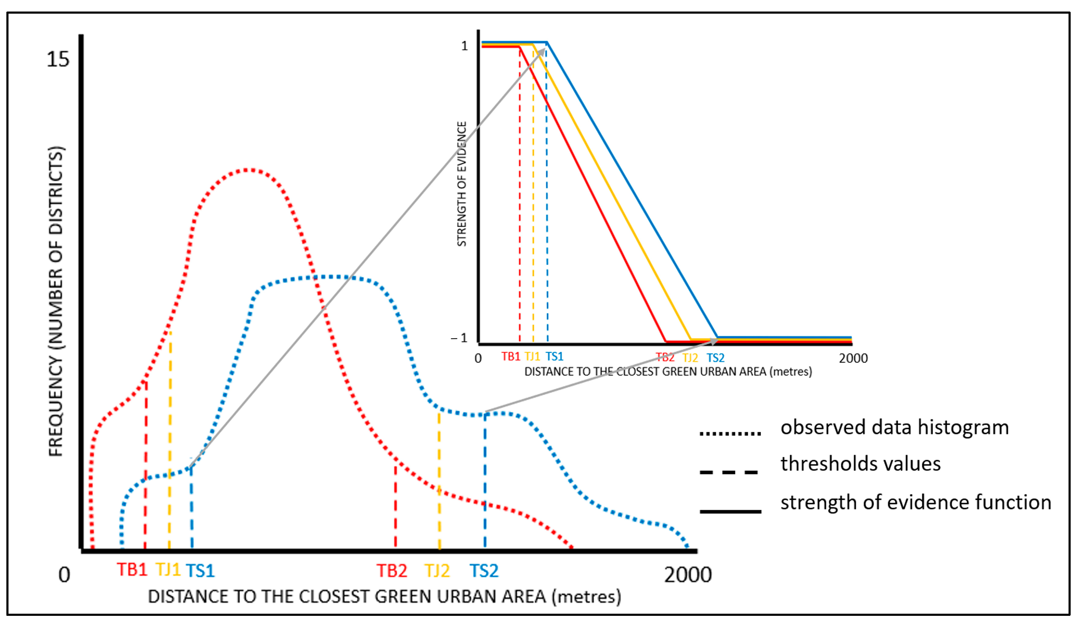
2.2.3. Comparison of Urban Ecosystem Services between the Two Cities

Given the model construction described in the previous section, we compared the provisions of the UES within the districts of the cities and between the cities. Because the metrics we implemented had different absolute ranges between the two cities, resulting in distinct scales for the provision of a metric, they were not directly comparable. Therefore, we tested two different methods to analyse the UES provision and, subsequently, compared the provisioning outcomes between Santiago and Barcelona. The difference between the two methods was based on the assignment of the thresholds used to define the fuzzy membership functions, as described in the previous section. In the first method, which we refer to as the separated thresholds approach, the observed data values were analysed independently for each city and unique thresholds were calculated separately for Santiago and Barcelona. The maximum and minimum threshold values for defining the fuzzy membership functions in each city were assigned based on the literature review for recreation and noise reduction, or based on the 15th and the 85th percentiles for the other UES indicators (Table 4). On the other hand, in the second method, the joint thresholds approach, the analysis was run with the unique threshold values for defining the fuzzy membership functions determined based on both study areas (Figure 3). In particular, the threshold values of the fuzzy membership functions in the joint threshold approach were calculated as the mean threshold values from the separated thresholds approach (Table 4).
The spatial analysis was performed using the ArcGIS 10.8 software, as well as the EMDS 8.7 ArcMap Add-Inn. After running the NetWeaver model in EMDS, maps showing the provision of each UES indicator, the UES groups, and the total UES provision were generated. Lastly, we noted that the strength of the evidence measures computed in NetWeaver was a continuous variable, but the map values were classified into five categories using equal intervals, from very low to very high, for display purposes.

2.2.4. Spatial Aggregation and Variation Analysis

In this final step, the total provision scores resulting from the two different methods were compared and analysed. For this purpose, the strength of the evidence values (ranging from −1 to 1) were normalized to a (0–1) scale to simplify the interpretation. The normalized provision scores obtained with the separated thresholds approach were deducted from the value obtained using the joint thresholds approach. The results depict the degree (0–1 or 0–100%) and direction (positive or negative) of the changes in the provision resulting from the application of the two different methods. Additionally, the changes in the spatial aggregation of the provisions per district were analysed by applying global Moran’s I statistics, a spatial autocorrelation tool that assesses both spatial locations and changes in the values of features [62]. Applying Moran’s I, we aimed to assess the equality in the provision of the UES and, therefore, urban well-being. A lack of spatial correlation (negative I values) means a lower aggregation and greater equality in this provision, and vice versa [63]. We aimed to compare the results obtained by the two different methods to identify the gap between the provisions of the cities and study the relativeness regarding the optimal provision of UES.

3. Results

The spatial distribution of the provision of UES in Santiago, calculated using the separated thresholds approach, is shown in Figure 4. The provision of the cultural and regulating UES did not follow a common spatial pattern. The provision of cultural services was generally low within the entire study area, with the exception of a few specific districts where a higher provision could be noticed. On the other hand, the provision of regulating services showed a clear east–west spatial polarization. While a very low strength of evidence dominated the central and western districts of the city, with several low and medium values, the eastern districts displayed continuous areas of very high provision. With respect to the total provision of UES in Santiago, a more irregular spatial pattern was evident, maintaining the high strength of the evidence values in the east, but with less distinctive differences towards the west.
Figure 5 shows the spatial distribution of the UES in Barcelona, calculated using the separated thresholds approach. In comparison to Santiago, the spatial distributions of both the cultural and regulating services were more irregular. Generally, higher values were observed in the marginal districts of the city, leaving the central districts characterised by a lower strength of evidence. The regulating services showed a greater polarisation in their values within the study area, while the score differences for the cultural services were smoother. The total provision of UES in Barcelona had an uneven spatial distribution. In general terms, very high provision values were observed in the districts where parks or urban forests were situated, located in the mountainous parts of the city; coastal districts had medium values, while an irregular representativeness of very low, low, and medium scores could be noticed in the central portion of the study area.
Figure 6 shows the total provision of the UES in Santiago and Barcelona when applying the joint threshold approach. The spatial distributions of the provisioning values followed a similar spatial pattern in both cities, as in the previous method. However, changes in these provision values could be noticed in both study areas. In Santiago, about 50% of the city districts showed an increase, while in the other 50% of the districts, lower provision values were observed. Nevertheless, negative variations were more frequent (the mean decrease value was −0.04, while the mean increase value was 0.02), indicated by the predominance of lighter shades in Figure 6. Most of the districts registered changes in their values passing from high to medium in the east, or low to very low in the western parts of the city. Only a few city districts had a significant increase in their provision after applying the joint thresholds approach compared to the separated thresholds approach (Figure 4). On the contrary, most districts of Barcelona showed an increase in their UES provision scores, about 80% of the total number. At the same time, the mean variation values were equal in both the positive and negative records. Most coastal districts passed from a medium to high strength of evidence. The provision increased from very low to low and low to medium in several central city areas, while increments from medium to high and high to very high were observed in the mountain districts. A significant decrease in provision was only registered in a few suburban areas, mostly passing from very high to high.
The variations in the provisioning values between the two methods were much higher in Barcelona than Santiago, both in terms of positive and negative changes. After using the joint thresholds approach, the provision values in Barcelona predominantly increased, with scores of up to 20% higher. On the other hand, when the provision scores in Santiago were directly compared to the absolute provision values in Barcelona, smoother variations were noticed, but with a greater decreasing tendency, reaching up to −10%.
Regarding the spatial aggregation of the UES provision values, positive Moran’s I values were obtained from both the separated and joint thresholds approaches in both cities, indicating some degree of aggregation. However, significant differences were observed between Santiago and Barcelona. First, the spatial aggregation of the total UES provision was higher in Santiago than Barcelona. The Moran’s I in Santiago was 0.53, both for the separated thresholds and joint thresholds approaches, while the respective values in Barcelona were 0.19 and 0.15. Thus, the aggregation of the total provision varied more in Barcelona than Santiago when comparing the two threshold approaches. Differences in the spatial aggregation were also observed in the provision of regulating UES using the joint thresholds approach, in which Santiago had a high index value (0.63), whereas Barcelona had a low value (0.12).

4. Discussion

In this study, we conducted two different comparison methods for evaluating the provision of UES in the cities of Santiago and Barcelona. In both cases, an innovative spatial decision support framework, EMDS, was applied to allow the analysis of single and combined UES provisions. We used the same data in both approaches, only changing the threshold values to define low and high evidence of UES provision, which were primarily derived from evaluations of histograms of data distributions. After the application of the different threshold approaches, clearly distinct results were obtained for both cities, resulting in changed provision evidence values. Because the identification of the needed interventions to the green infrastructure and the specification of the actions required to improve urban green and human well-being are directly conditioned by the characteristics of UES supply, knowing their current state and managing them appropriately is crucial [64]. Our approach also attempted to develop standardised comparison methods for reducing ambiguities in the results, as well as provide a spatial solution for analysing UES to support urban planning policies that, in turn, provide a basis for a less ambiguous definition of a good urban strategy [65].
The provision of ecosystem services, including UES, primarily depends on the capacity of the ecosystem to deliver them [31]. While in rural environments it might be a challenging task to change the ecosystem capacity in the short term, urban environments are characterised by more dynamic geospatial features that are amenable to implementing changes. Namely, via land-use changes or interventions to urban facilities, environmental settings can be substantially changed in a relatively short time, enabling new scenarios for UES provision [66]. Ideally, these changes should be induced by prior analyses of the current UES characteristics, aimed at improving them [2]. The comparison analyses presented in this study can substantially help in defining the actions needed to initiate these changes and, therefore, act as a useful tool in UES management. These types of analyses can also improve the awareness of the need to continue improving urban ecosystems and increasing UES provision. Our results illustrate how the perceptions of provision values in a certain city can change by considering alternative comparison methods. Such perceptions can result in obtaining a wrong image of UES-related processes and their provisions and can lead to making inappropriate decisions regarding urban planning. For example, generally high provision values were observed in the eastern part of Santiago when the data were analysed independently, but after observing the results in the broader context of the joint comparison method, which included data from Barcelona, the provision in Santiago decreased, whereas the opposite outcome was observed in Barcelona. In other words, when using the separated thresholds approach, the high values in Santiago and Barcelona were not equally high, which emphasized the relativeness in the provision of UES in this approach. This can easily cause difficulties with defining an appropriate urban planning strategy that attempts to improve the distribution of environmental goods and well-being. This also raises questions about the methodology for such comparison studies and which scores the provision should register to be considered as high enough. Until now, a UES comparison between different cities has only been conducted in a limited number of studies, with a clear lack of coherent comparison methods [3,16], and these have been based on what we refer to as the separated thresholds method, in which each dataset, before being compared, is analysed and normalised independently. As demonstrated in this study, such methods can provide misleading results, because their provision scales are based on different absolute values. While there is an objective at the global level focused on the urgent mitigation of the inequality of environmental goods, the development of research methodology does not follow the same path [25]. It is evident that each urban area has a unique geospatial reality defined by specific sets of features, including urban green infrastructure, and that the capacity of UES provision strongly depends on these characteristics, but effective improvements cannot be achieved at a broader global scale if each urban landscape is analysed independently. Thus, in this study, we emphasized the need to improve UES comparison methods, in order to obtain more comparable results, which would help to achieve a more equal distribution of urban well-being across cities by establishing more standardised comparison methods, such as the definition of UES thresholds that could be applicable over broad spatial extents.
Regarding provision values, the literature usually strives for an increase in UES supply, but there is no consensus on how high this provision should be to satisfactorily supply all the benefits. In rural environments, the goal is to achieve the maximum provision that the environment can provide according to its capacity, without putting it at environmental risk [67]. In urban environments, this capacity can easily be increased, but the environmental pressure on UGAs can also fluctuate drastically, depending on geographical circumstances [68]. The joint thresholds method that was demonstrated in this study can help to evaluate UES provision over broader spatial extents and provide a better perception of the comparability of UES characteristics (or lack thereof), but it cannot produce a complete solution for the actions needed to manage UGAs. At the same time, we recognize that, in some cases, the absolute values for the provision of UES can be so different that it may not make sense to adjust their interpretation to a common data scale. However, using the separated thresholds approach in the latter case would give even more problematic results, as discussed above. For this reason, the study also emphasizes the methodological constraints regarding UES comparisons, although it represents a first step towards more complete comparison methods, while also emphasising the need for more developed and elaborated methodological approaches.
The EMDS system that was used in this study enables the application of geospatial modelling to assess the complexity of the urban environment. Although EMDS had not previously been applied in UES-related studies, the system shows several strengths in resolving complex spatial problems. Apart from well-established terminology that facilitates the interpretation of results, a user-friendly interface enables the consideration of spatial complexities in a relatively simple way [69]. The latter features help to strengthen the collaboration between scientists and end-users, facilitating EMDS application in participatory planning. The possibility of the implementation of such methodology, with a combination of expert knowledge and scientific methods, is of great interest in UES-related decision making processes [70].
A spatial analysis of UES provision, as illustrated in this study, is a useful foundation for decision makers in setting policies and developing strategies for improving the provisioning of UES in urban landscapes, insofar as it spatially quantifies the current state of the urban environment with respect to its current status. However, to effectively support decision making in this context, additional decision tools are needed to: (1) identify which urban districts are the best targets for improvements in UES provision (e.g., strategic planning), and (2) identify what specific actions in those districts would produce the biggest gain in provisioning (e.g., tactical planning). While the spatial analysis of UES provisioning was relatively objective, the subsequent decision analyses were relatively subjective, but could be assisted by tools for a multi-criteria decision analysis (MCDA, [71]) that helps decision makers to organize the decision criteria into models, decide on the relative importance of these criteria, and document the decision models, in order to facilitate stakeholder participation. While the current study only addressed a foundational spatial analysis of UES provisioning, the EMDS system includes a variety of MCDA methods that can be applied to extend the current EMDS applications to the strategic and tactical phases of decision support for UES provisioning.

5. Conclusions

In this study, we assessed the provision of UES in Barcelona, Spain, and Santiago, Chile, implementing two different comparison methods. The EMDS spatial decision support framework was applied for the data modelling and results interpretation. The results demonstrated different levels of UES provisioning, depending on the methodological approach used, and reflected the relativeness in UES provision, which presents difficulties in developing effective strategic and tactical solutions for urban planning. Therefore, we suggested that UES comparison methods are useful tools for detecting environmental injustice in urban areas and supporting better UGA management. Still, it has to be considered that the standardization processes required for comparisons between urban entities may neglect the use of highly specific but relevant information.

Author Contributions

All authors participated on the conceptualization of the project. G.K. and S.R.-P. implemented the data preparation. G.K. did the analysis and wrote an initial draft. K.M.R. supervised the development and implementation of EMDS framework. G.K., J.R.G.O. and J.G.-G. analysed the results. All authors participated in in editing process of the manuscript. All authors have read and agreed to the published version of the manuscript.

Funding

This work was funded by the Catalan government predoctoral scholarship (AGAUR-FSE 2020 FI_B2 00147), SuFoRun Marie Sklodowska-Curie Research and Innovation Staff Exchange (RISE) Program (Grant agreement No: 691149) and AGAUR, as support to the “Forest Landscape Planning and Decision Making; towards resilient landscapes (ForPLADEM)”, GRC (2021 SGR 01544).

Data Availability Statement

Archive 1, containing data used in the analysis, is elaborated and available upon request from the corresponding author.

Conflicts of Interest

The authors declare no conflict of interest. The use of trade or firm names in this publication is for reader information and does not imply endorsement by the U.S. Department of Agriculture of any product or service.

References

  1. Bolund, P.; Hunhammar, S. Ecosystem services in urban areas. Ecol. Econ. 1999, 29, 293–301. [Google Scholar] [CrossRef]
  2. Gómez-Baggethun, E.; Barton, D.N. Classifying and valuing ecosystem services for urban planning. Ecol. Econ. 2013, 86, 235–245. [Google Scholar] [CrossRef]
  3. Kourdounouli, C.; Jönsson, A.M. Urban ecosystem conditions and ecosystem services–a comparison between large urban zones and city cores in the EU. J. Environ. Plan. Manag. 2020, 63, 798–817. [Google Scholar] [CrossRef]
  4. Dobbs, C.; Kendal, D.; Nitschke, C.R. Multiple ecosystem services and disservices of the urban forest establishing their connections with landscape structure and sociodemographics. Ecol. Indic. 2014, 43, 44–55. [Google Scholar] [CrossRef]
  5. Kraemer, R.; Kabisch, N. Parks in context: Advancing citywide spatial quality assessments of urban green spaces using fine-scaled indicators. Ecol. Soc. 2021, 26, 45. [Google Scholar] [CrossRef]
  6. Derkzen, M.L.; van Teeffelen, A.J.A.; Verburg, P.H. REVIEW: Quantifying urban ecosystem services based on high-resolution data of urban green space: An assessment for Rotterdam, the Netherlands. J. Appl. Ecol. 2015, 52, 1020–1032. [Google Scholar] [CrossRef]
  7. Wilkerson, M.L.; Mitchell, M.G.; Shanahan, D.; Wilson, K.; Ives, C.D.; Lovelock, C.; Rhodes, J. The role of socio-economic factors in planning and managing urban ecosystem services. Ecosyst. Serv. 2018, 31, 102–110. [Google Scholar] [CrossRef]
  8. Niemelä, J.; Saarela, S.-R.; Söderman, T.; Kopperoinen, L.; Yli-Pelkonen, V.; Väre, S.; Kotze, D.J. Using the ecosystem services approach for better planning and conservation of urban green spaces: A Finland case study. Biodivers. Conserv. 2010, 19, 3225–3243. [Google Scholar] [CrossRef]
  9. Holt, A.R.; Mears, M.; Maltby, L.; Warren, P. Understanding spatial patterns in the production of multiple urban ecosystem services. Ecosyst. Serv. 2015, 16, 33–46. [Google Scholar] [CrossRef]
  10. Dobbs, C.; Hernández-Moreno, Á.; Reyes-Paecke, S.; Miranda, M.D. Exploring temporal dynamics of urban ecosystem services in Latin America: The case of Bogota (Colombia) and Santiago (Chile). Ecol. Indic. 2018, 85, 1068–1080. [Google Scholar] [CrossRef]
  11. Dobbs, C.; Escobedo, F.J.; Zipperer, W.C. A framework for developing urban forest ecosystem services and goods indicators. Landsc. Urban Plan. 2011, 99, 196–206. [Google Scholar] [CrossRef]
  12. Li, F.; Guo, S.; Li, D.; Li, X.; Li, J.; Xie, S. A multi-criteria spatial approach for mapping urban ecosystem services demand. Ecol. Indic. 2020, 112, 106119. [Google Scholar] [CrossRef]
  13. Gold, S.M. Social benefits of trees in urban environmentst. Int. J. Environ. Stud. 1976, 10, 85–90. [Google Scholar] [CrossRef]
  14. Parsa, V.A.; Salehi, E.; Yavari, A.R.; van Bodegom, P.M. Evaluating the potential contribution of urban ecosystem service to climate change mitigation. Urban Ecosyst. 2019, 22, 989–1006. [Google Scholar] [CrossRef]
  15. Xu, C.; Jiang, W.; Huang, Q.; Wang, Y. Ecosystem services response to rural-urban transitions in coastal and island cities: A comparison between Shenzhen and Hong Kong, China. J. Clean. Prod. 2020, 260, 121033. [Google Scholar] [CrossRef]
  16. Grêt-Regamey, A.; Galleguillos-Torres, M.; Dissegna, A.M.; Weibel, B. How urban densification influences ecosystem services—A comparison between a temperate and a tropical city. Environ. Res. Lett. 2020, 15, 075001. [Google Scholar] [CrossRef]
  17. Subiza-Pérez, M.; Vozmediano, L.; Juan, C.S. Landscape and Urban Planning Green and blue settings as providers of mental health ecosystem services: Comparing urban beaches and parks and building a predictive model of psychological restoration. Landsc. Urban Plan. 2020, 204, 103926. [Google Scholar] [CrossRef]
  18. Bing, Z.; Qiu, Y.; Huang, H.; Chen, T.; Zhong, W.; Jiang, H. Spatial distribution of cultural ecosystem services demand and supply in urban and suburban areas: A case study from Shanghai, China. Ecol. Indic. 2021, 127, 107720. [Google Scholar] [CrossRef]
  19. Remme, R.; de Nijs, T.; Paulin, M. Natural Capital Model—Technical Documentation of the Quantification, Mapping and Monetary Valuation of Urban Ecosystem Services. RIVM Report 2017-0040. 2018, p. 76. Available online: www.rivm.nl/en (accessed on 28 April 2023).
  20. Tavares, P.A.; Beltrão, N.; Guimarães, U.S.; Teodoro, A.; Gonçalves, P. Urban ecosystem services quantification through remote sensing approach: A systematic review. Environments 2019, 6, 51. [Google Scholar] [CrossRef]
  21. Alemu, J.B.; Richards, D.R.; Gaw, L.Y.-F.; Masoudi, M.; Nathan, Y.; Friess, D.A. Identifying spatial patterns and interactions among multiple ecosystem services in an urban mangrove landscape. Ecol. Indic. 2021, 121, 107042. [Google Scholar] [CrossRef]
  22. Shiraishi, K. The inequity of distribution of urban forest and ecosystem services in Cali, Colombia. Urban For. Urban Green. 2022, 67, 127446. [Google Scholar] [CrossRef]
  23. Watkins, S.L.; Gerrish, E. The relationship between urban forests and race: A meta-analysis. J. Environ. Manag. 2018, 209, 152–168. [Google Scholar] [CrossRef] [PubMed]
  24. Escobedo, F.J.; Clerici, N.; Staudhammer, C.L.; Corzo, G.T. Socio-ecological dynamics and inequality in Bogotá, Colombia’s public urban forests and their ecosystem services. Urban For. Urban Green. 2015, 14, 1040–1053. [Google Scholar] [CrossRef]
  25. Konijnendijk, C.C. Evidence-based guidelines for greener, healthier, more resilient neighbourhoods: Introducing the 3–30–300 rule. J. For. Res. 2022, 34, 821–830. [Google Scholar] [CrossRef] [PubMed]
  26. Nahlik, A.M.; Kentula, M.E.; Fennessy, M.S.; Landers, D.H. Where is the consensus? A proposed foundation for moving ecosystem service concepts into practice. Ecol. Econ. 2012, 77, 27–35. [Google Scholar] [CrossRef]
  27. Blanco, E.; Raskin, K.; Clergeau, P. Towards regenerative neighbourhoods: An international survey on urban strategies promoting the production of ecosystem services. Sustain. Cities Soc. 2022, 80, 103784. [Google Scholar] [CrossRef]
  28. Haase, D.; Larondelle, N.; Andersson, E.; Artmann, M.; Borgström, S.; Breuste, J.; Gomez-Baggethun, E.; Gren, Å.; Hamstead, Z.; Hansen, R.; et al. A quantitative review of urban ecosystem service assessments: Concepts, models, and implementation. Ambio 2014, 43, 413–433. [Google Scholar] [CrossRef]
  29. Grêt-Regamey, A.; Sirén, E.; Brunner, S.H.; Weibel, B. Review of decision support tools to operationalize the ecosystem services concept. Ecosyst. Serv. 2017, 26, 306–315. [Google Scholar] [CrossRef]
  30. Reynolds, K.M.; Hessburg, P.F. An Overview of the Ecosystem Management Decision-Support System. In Making Transparent Environmental Management Decisions. Environmental Science and Engineering; Springer: Berlin/Heidelberg, Germany, 2014; pp. 3–22. [Google Scholar] [CrossRef]
  31. Millennium Ecosystem Assessment. Ecosystems and Human Well-Being; Island Press: Washington, DC, USA, 2005. [Google Scholar]
  32. Montoya-Tangarife, C.; de la Barrera, F.; Salazar, A.; Inostroza, L. Monitoring the effects of land cover change on the supply of ecosystem services in an urban region: A study of Santiago-Valparaíso, Chile. PLoS ONE 2017, 12, e0188117. [Google Scholar] [CrossRef]
  33. Zhang, S.; Ramírez, F.M. Assessing and mapping ecosystem services to support urban green infrastructure: The case of Barcelona, Spain. Cities 2019, 92, 59–70. [Google Scholar] [CrossRef]
  34. Baró, F.; Palomo, I.; Zulian, G.; Vizcaino, P.; Haase, D.; Gómez-Baggethun, E. Mapping ecosystem service capacity, flow and demand for landscape and urban planning: A case study in the Barcelona metropolitan region. Land Use Policy 2016, 57, 405–417. [Google Scholar] [CrossRef]
  35. Dobbs, C.; Escobedo, F.J.; Clerici, N.; De La Barrera, F.; Eleuterio, A.A.; MacGregor-Fors, I.; Reyes-Paecke, S.; Vásquez, A.; Camaño, J.D.Z.; Hernández, H.J. Urban ecosystem Services in Latin America: Mismatch between global concepts and regional realities? Urban Ecosyst. 2019, 22, 173–187. [Google Scholar] [CrossRef]
  36. National Statistics Institute. Residents in Spain. 2022. Available online: https://www.ine.es/index.htm (accessed on 30 January 2023).
  37. National Statistics Institute. Census. 2017. Available online: https://www.ine.gob.cl/censo (accessed on 30 January 2023).
  38. Kourtzanidis, K.; Angelakoglou, K.; Giourka, P.; Tsarchopoulos, P.; Nikolopoulos, N.; Ioannidis, D.; Kantorovitch, J.; Formiga, J.; Verbeek, K.; de Vries, M.; et al. World map of the Köppen-Geiger climate classification updated. Meteorol. Z. 2006, 15, 259–263. [Google Scholar] [CrossRef]
  39. Cui, F.; Hamdi, R.; Yuan, X.; He, H.; Yang, T.; Kuang, W.; Termonia, P.; De Maeyer, P. Quantifying the response of surface urban heat island to urban greening in global north megacities. Sci. Total. Environ. 2021, 801, 149553. [Google Scholar] [CrossRef]
  40. Myeong, S.; Nowak, D.J.; Duggin, M.J. A temporal analysis of urban forest carbon storage using remote sensing. Remote Sens. Environ. 2006, 101, 277–282. [Google Scholar] [CrossRef]
  41. Armson, D.; Stringer, P.; Ennos, A. The effect of street trees and amenity grass on urban surface water runoff in Manchester, UK. Urban For. Urban Green. 2013, 12, 282–286. [Google Scholar] [CrossRef]
  42. Kuehler, E.; Hathaway, J.; Tirpak, A. Quantifying the benefits of urban forest systems as a component of the green infrastructure stormwater treatment network. Ecohydrology 2017, 10, e1813. [Google Scholar] [CrossRef]
  43. Dzhambov, A.; Dimitrova, D. Urban green spaces’ effectiveness as a psychological buffer for the negative health impact of noise pollution: A systematic review. Noise Health 2014, 16, 157–165. [Google Scholar] [CrossRef]
  44. Gozalo, G.R.; Morillas, J.M.B.; González, D.M.; Moraga, P.A. Relationships among satisfaction, noise perception, and use of urban green spaces. Sci. Total. Environ. 2018, 624, 438–450. [Google Scholar] [CrossRef]
  45. Rudd, H.; Vala, J.; Schaefer, V. Importance of backyard habitat in a comprehensive biodiversity conservation strategy: A connectivity analysis of urban green spaces. Restor. Ecol. 2002, 10, 368–375. [Google Scholar] [CrossRef]
  46. Grunewald, K.; Richter, B.; Meinel, G.; Herold, H.; Syrbe, R.-U. Proposal of indicators regarding the provision and accessibility of green spaces for assessing the ecosystem service ‘recreation in the city’ in Germany. Int. J. Biodivers. Sci. Ecosyst. Serv. Manag. 2017, 13, 26–39. [Google Scholar] [CrossRef]
  47. Zhang, H.; Chen, B.; Sun, Z.; Bao, Z. Landscape perception and recreation needs in urban green space in Fuyang, Hangzhou, China. Urban For. Urban Green. 2013, 12, 44–52. [Google Scholar] [CrossRef]
  48. Plieninger, T.; Dijks, S.; Oteros-Rozas, E.; Bieling, C. Assessing, mapping, and quantifying cultural ecosystem services at community level. Land Use Policy 2013, 33, 118–129. [Google Scholar] [CrossRef]
  49. Ulmer, J.M.; Wolf, K.L.; Backman, D.R.; Tretheway, R.L.; Blain, C.J.; O’neil-Dunne, J.P.; Frank, L.D. Multiple health benefits of urban tree canopy: The mounting evidence for a green prescription. Health Place 2016, 42, 54–62. [Google Scholar] [CrossRef]
  50. Wolf, K.L.; Lam, S.T.; McKeen, J.K.; Richardson, G.R.; Bosch, M.v.D.; Bardekjian, A.C. Urban Trees and Human Health: A Scoping Review. Int. J. Environ. Res. Public Health 2020, 17, 4371. [Google Scholar] [CrossRef]
  51. Riechers, M.; Barkmann, J.; Tscharntke, T. Perceptions of cultural ecosystem services from urban green. Ecosyst. Serv. 2016, 17, 33–39. [Google Scholar] [CrossRef]
  52. Hu, T.; Wei, D.; Su, Y.; Wang, X.; Zhang, J.; Sun, X.; Liu, Y.; Guo, Q. Quantifying the shape of urban street trees and evaluating its influence on their aesthetic functions based mobile lidar data. ISPRS J. Photogramm. Remote Sens. 2022, 184, 203–214. [Google Scholar] [CrossRef]
  53. Chuvieco, E. Teledetección Ambiental; Ariel: Barcelona, Spain, 2010. [Google Scholar]
  54. Jime, J.C. A generalized single-channel method for retrieving land surface temperature from remote sensing data. J. Geophys. Res. Atmos. 2004, 108, D22. [Google Scholar] [CrossRef]
  55. Valor, E.; Caselles, V. Mapping land surface emissivity from NDVI: Application to European, African, and South American areas. Remote Sens. Environ. 1996, 57, 167–184. [Google Scholar] [CrossRef]
  56. Barcelona’s City Hall Open Data Service. Available online: https://opendata-ajuntament.barcelona.cat/en (accessed on 31 January 2023).
  57. Dormidontova, V.; Belkin, A. The Continuity of Open Greened Spaces-Basic Principle of Urboecology. IOP Conf. Ser. Mater. Sci. Eng. 2020, 753, 022048. [Google Scholar] [CrossRef]
  58. Puigdollers, J. Barcelona Green Infrastructure and Biodiversity Plan 2020. Barcelona, Spain (in Spanish, English Summary). 2013, p. 111. Available online: http://scholar.google.com/scholar?hl=en&btnG=Search&q=intitle:Barcelona+green+infrastructure+and+biodiversity+plan+2020.#0 (accessed on 28 April 2023).
  59. Hernández-Morcillo, M.; Plieninger, T.; Bieling, C. An empirical review of cultural ecosystem service indicators. Ecol. Indic. 2013, 29, 434–444. [Google Scholar] [CrossRef]
  60. Geospatial Data Infrastructure. Available online: https://www.ide.cl/ (accessed on 31 January 2023).
  61. Miller, B.J.; Saunders, M.C. NetWeaver Reference Manual; Pennsylvania State University: College Park, PA, USA, 2002; p. 127. [Google Scholar]
  62. Getis, A.; Ord, J.K. The Analysis of Spatial Association by Use of Distance Statistics. Geogr. Anal. 1992, 24, 189–206. [Google Scholar] [CrossRef]
  63. Goodchild, M.F.; Janelle, D.G. (Eds.) Spatially Integrated Social Science. In Spatial Information Systems; Oxford University Press: Oxford, UK, 2004. [Google Scholar]
  64. Liu, L.; Wu, J. Scenario analysis in urban ecosystem services research: Progress, prospects, and implications for urban planning and management. Landsc. Urban Plan. 2022, 224, 104433. [Google Scholar] [CrossRef]
  65. Romero-Duque, L.P.; Trilleras, J.; Castellarini, F.; Quijas, S. Ecosystem services in urban ecological infrastructure of Latin America and the Caribbean: How do they contribute to urban planning? Sci. Total. Environ. 2020, 728, 138780. [Google Scholar] [CrossRef] [PubMed]
  66. McPhearson, T.; Andersson, E.; Elmqvist, T.; Frantzeskaki, N. Resilience of and through urban ecosystem services. Ecosyst. Serv. 2015, 12, 152–156. [Google Scholar] [CrossRef]
  67. Polasky, S.; Lewis, D.J.; Plantinga, A.J.; Nelson, E. Implementing the optimal provision of ecosystem services. Proc. Natl. Acad. Sci. USA 2014, 111, 6248–6253. [Google Scholar] [CrossRef] [PubMed]
  68. Spangenberg, J.H.; Görg, C.; Truong, D.T.; Tekken, V.; Bustamante, J.V.; Settele, J. Provision of ecosystem services is determined by human agency, not ecosystem functions. Four case studies. Int. J. Biodivers. Sci. Ecosyst. Serv. Manag. 2014, 10, 40–53. [Google Scholar] [CrossRef]
  69. Reynolds, K.M. EMDS 3.0: A modeling framework for coping with complexity in environmental assessment and planning. Sci. China Technol. Sci. 2006, 49 (Suppl. S1), 63–75. [Google Scholar] [CrossRef]
  70. Elliot, T.; Bertrand, A.; Babí Almenar, J.; Petucco, C.; Proença, V.; Rugani, B. Spatial optimisation of urban ecosystem services through integrated participatory and multi-objective integer linear programming. Ecol. Model. 2019, 409, 108774. [Google Scholar] [CrossRef]
  71. Huang, I.B.; Keisler, J.; Linkov, I. Multi-criteria decision analysis in environmental sciences: Ten years of applications and trends. Sci. Total. Environ. 2011, 409, 3578–3594. [Google Scholar] [CrossRef]
Figure 1. Study areas and relevant data layers.
Land 12 01088 g001
Figure 2. Graphic representation of NetWeaver model regarding the provision of regulating services in Barcelona.
Land 12 01088 g002
Figure 3. Schematic representation of threshold assignments for the strength of evidence function using recreation UES as an example. Red lines represent Barcelona (using separated thresholds approach), blue lines represent Santiago (using separated thresholds approach), and orange lines represent joint thresholds approach.
Land 12 01088 g003
Figure 4. Maps of provision of UES in Santiago using separated thresholds approach.
Land 12 01088 g004
Figure 5. Maps of provision of UES in Barcelona using separated thresholds approach.
Land 12 01088 g005
Figure 6. Maps of provision of UES in Santiago and Barcelona using joint thresholds approach.
Land 12 01088 g006
Table 1. Metrics selected to evaluate each of the 10 UES data inputs.
UES Groups and UES IndicatorsUES MetricsUnitsFormatMetrics References
REGULATING
Micro-climate regulationIntensity of urban heat island based on land surface temperature°CRaster[39]
Air quality regulationCO2 storage by urban treeskg/m2Raster[40]
DrainageExtension of impermeable surfaces or areas covered by vegetation%Raster[41,42]
Noise reductionPresence of green infrastructure along traffic axis%Polygon[43,44]
Habitat provisionContinuity of green urban areasm2Raster[45]
CULTURAL
RecreationDistance to the closest green urban area suitable for recreational activitiesmPoint[46,47]
Social valueQuantity of sites within urban green areas serving as a meeting point with other citizensnum./km2Point[48]
Psychological or health-related valueAbundance of urban green areas within neighbourhoodsm2/inh.Polygon[49,50]
Cultural or historical valueQuantity of urban green sites relevant to local culture or historynum./km2Point[51]
AestheticsPresence of green urban areas on the streets%Polygon[52]
Table 2. Landsat 8 images used in urban heat island calculation.
BarcelonaSantiago
DateResolutionDateResolution
12 July 201330 m multispectral, 100 m thermal pixel9 January 201430 m multispectral, 100 m thermal pixel
14 August 201630 m multispectral, 100 m thermal pixel15 January 201630 m multispectral, 100 m thermal pixel
22 July 201930 m multispectral, 100 m thermal pixel23 January 201930 m multispectral, 100 m thermal pixel
Table 3. NDVI thresholds applied in emissivity calculations.
Land Use TypeNDVI ThresholdsEmissivity Values
Vegetation>0.40.99
Water<00.98
Built-up areas0 ≤ NDVI < 0.10.95
Bare ground0.1 ≤ NDVI < 0.20.94
Mixed pixels0.2 ≤ NDVI < 0.4Equation by Valor and Caselles [55]
Table 4. Observed values thresholds to define strength of evidence values.
UES MetricsMetrics UnitsSeparated Thresholds ApproachJoint Thresholds Approach
BARCELONASANTIAGO
No EvidenceFull EvidenceNo EvidenceFull EvidenceNo EvidenceFull Evidence
Micro-climate regulation°C3331.535323431.75
Air quality regulationkg/m21.251.711.451.351.57
Drainage%124012501245
Habitat provisionm290080,00020004,000,00014502,000,000
Noise reduction%204010351537.5
Recreationm7001501000300850225
Social valuenum./km20150201.5
Psychological or health-related valuem2/inh.1230.11.20.5512.1
Cultural or historical valuenum./km201001.305.65
Aesthetics%10355357.535
Disclaimer/Publisher’s Note: The statements, opinions and data contained in all publications are solely those of the individual author(s) and contributor(s) and not of MDPI and/or the editor(s). MDPI and/or the editor(s) disclaim responsibility for any injury to people or property resulting from any ideas, methods, instructions or products referred to in the content.

