
The Evolution of Historic Agroforestry Landscape in the Northern Apennines (Italy) and Its Consequences for Slope Geomorphic Processes

Abstract
:1. Introduction
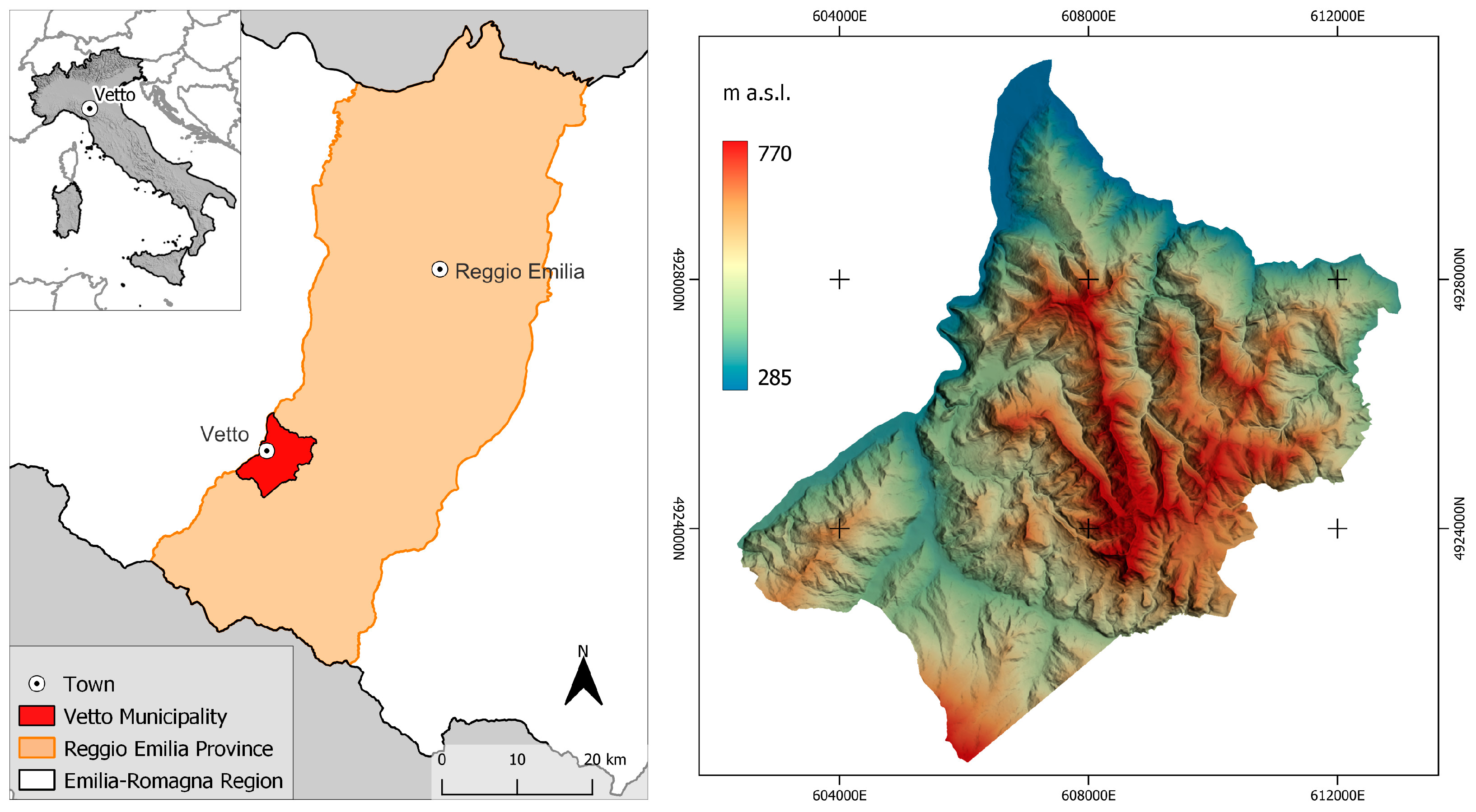
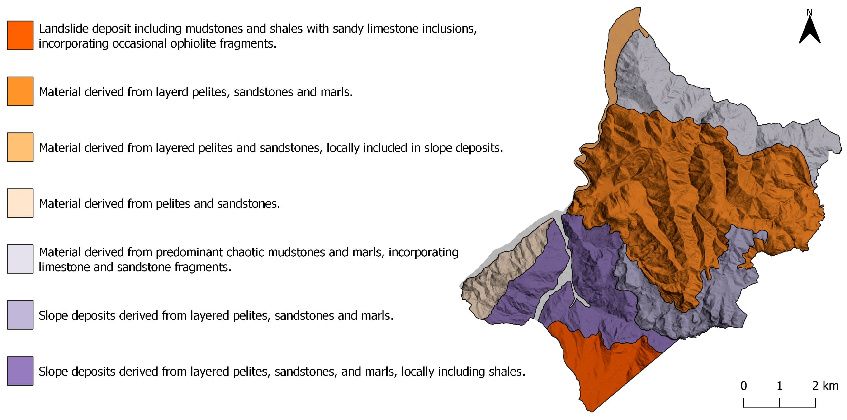
2. Study Area
3. Materials and Methods
3.1. Historical Sources
3.2. GIS—Historic Landscape Characterisation
3.3. Dendrochronology
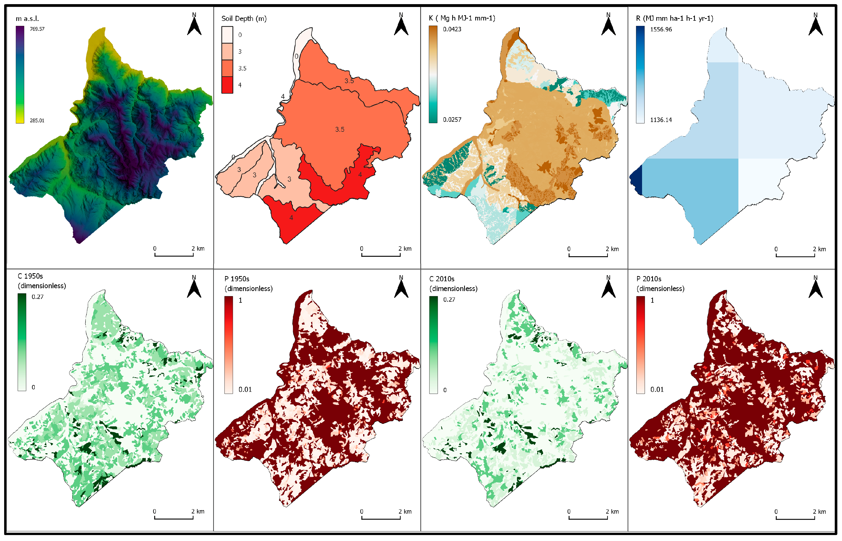
3.4. GIS Geomorphic Modelling
4. Results
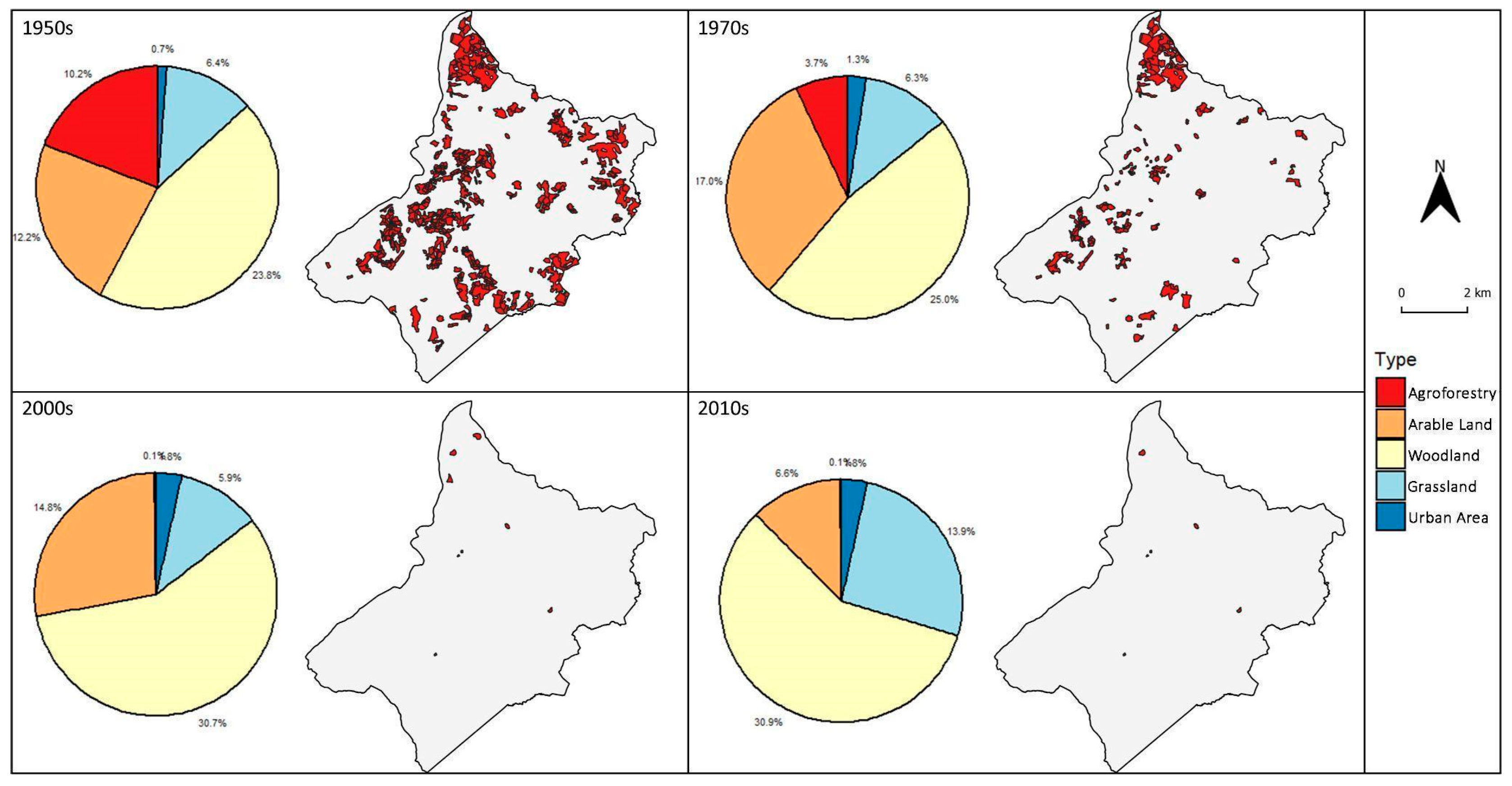
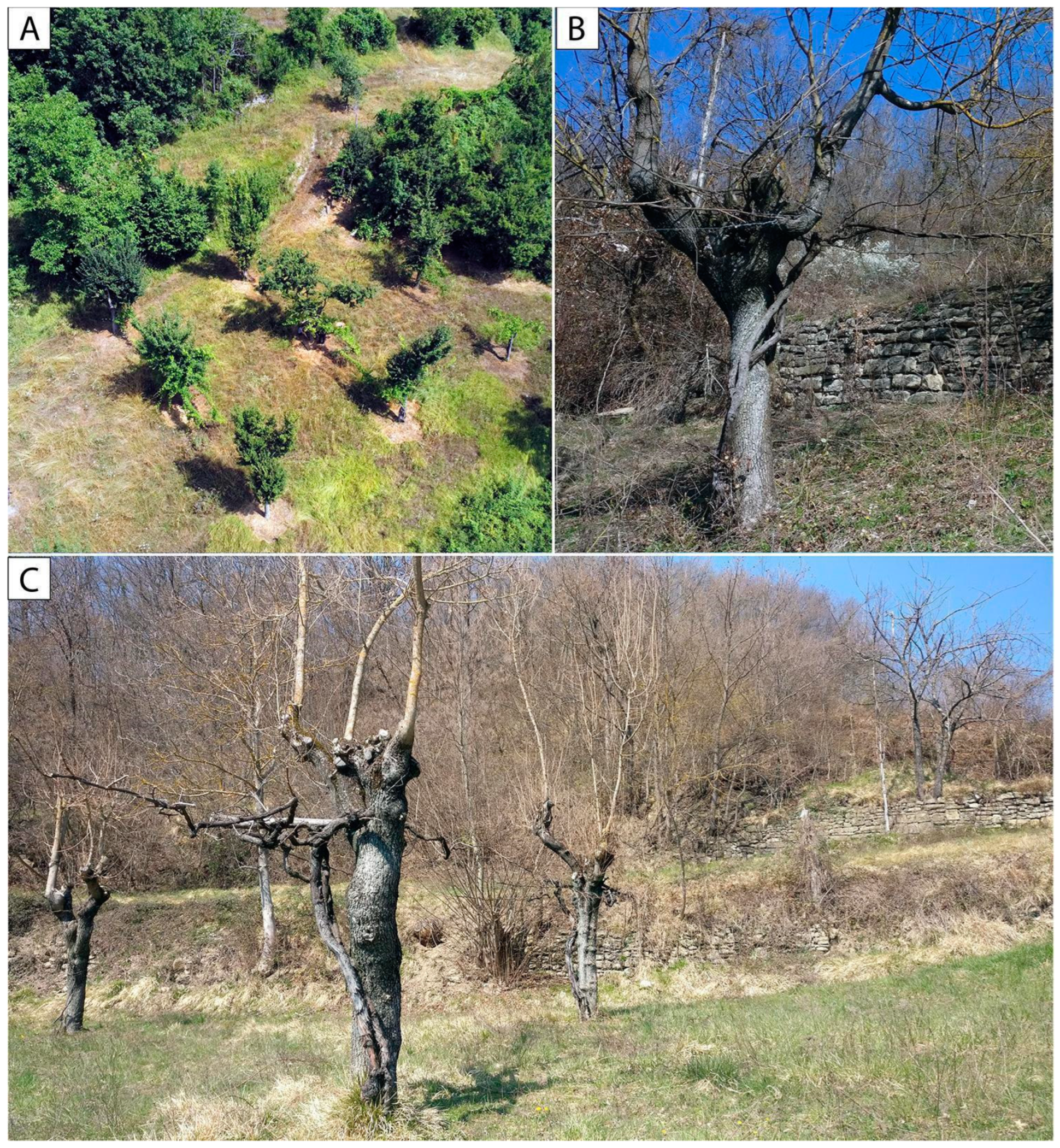
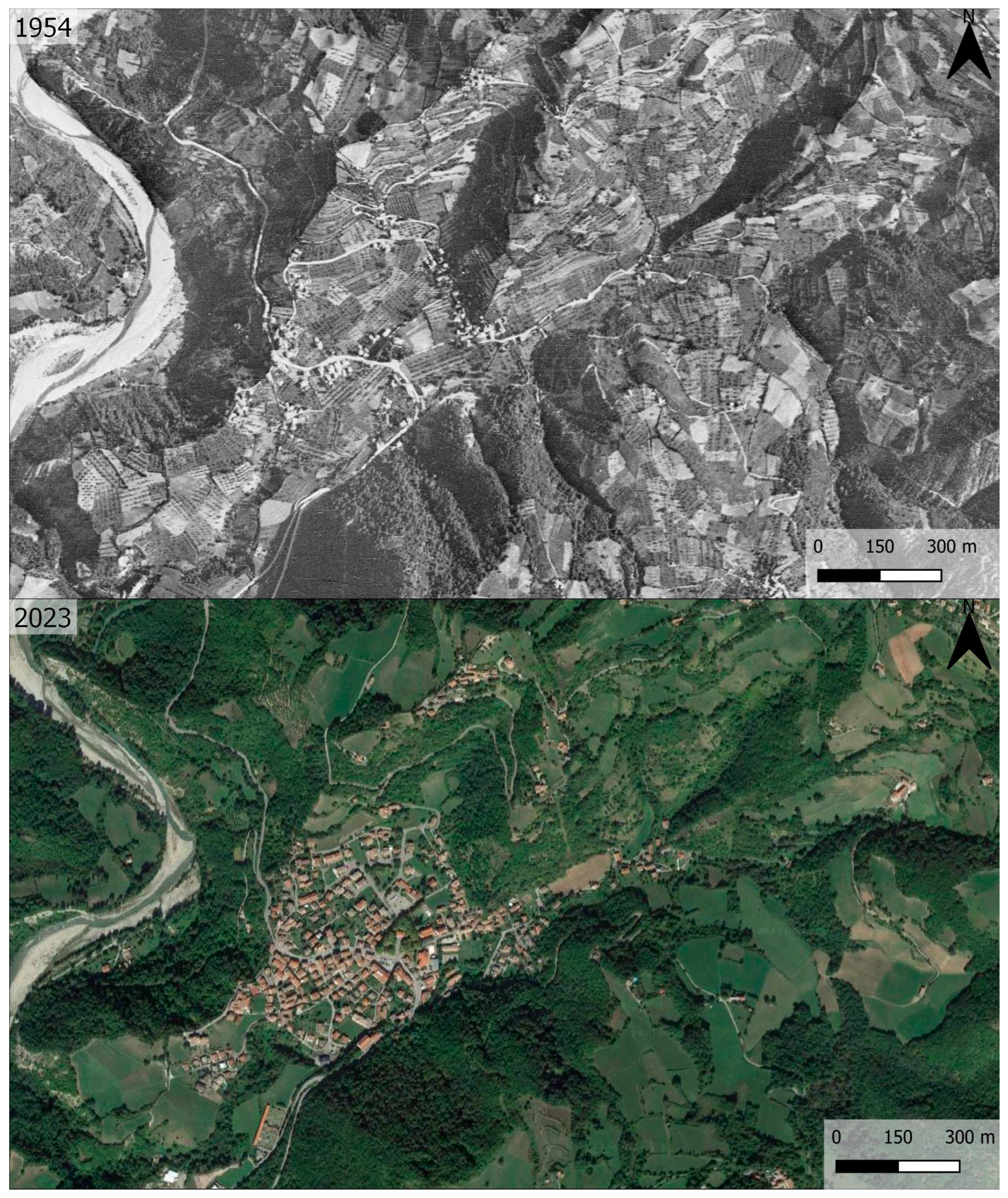
4.1. Historic Agroforestry Landscape: Genesis, Characteristics, and Decline
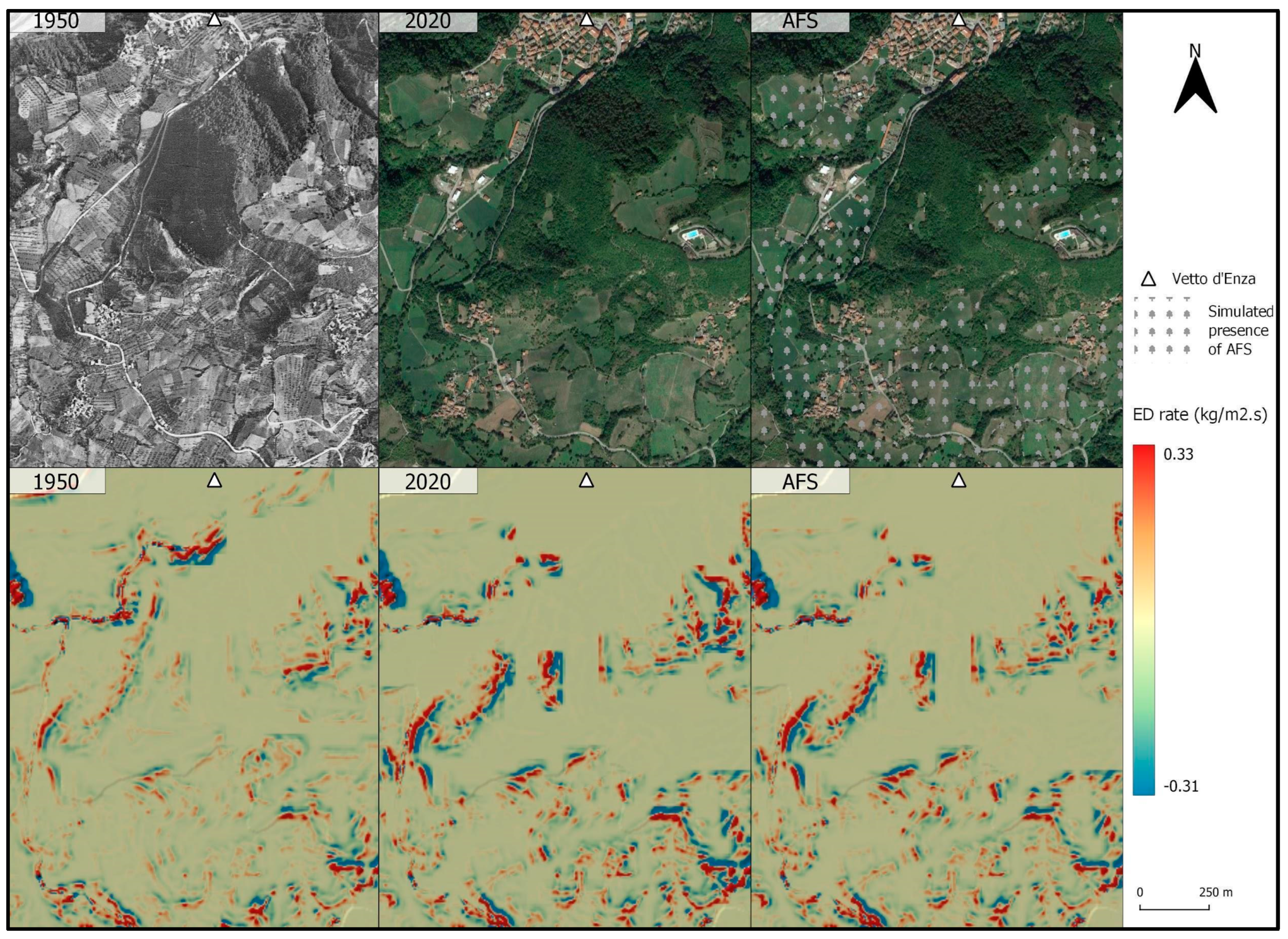
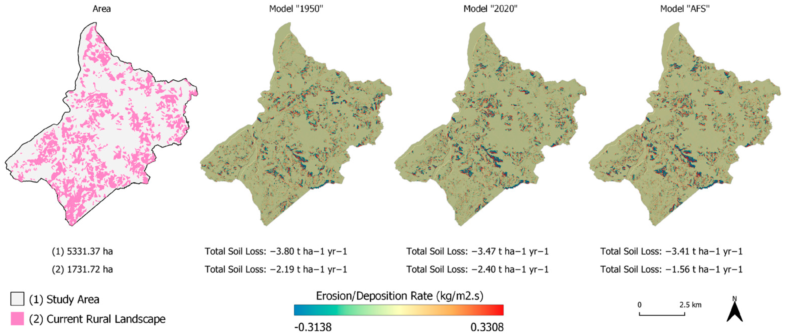
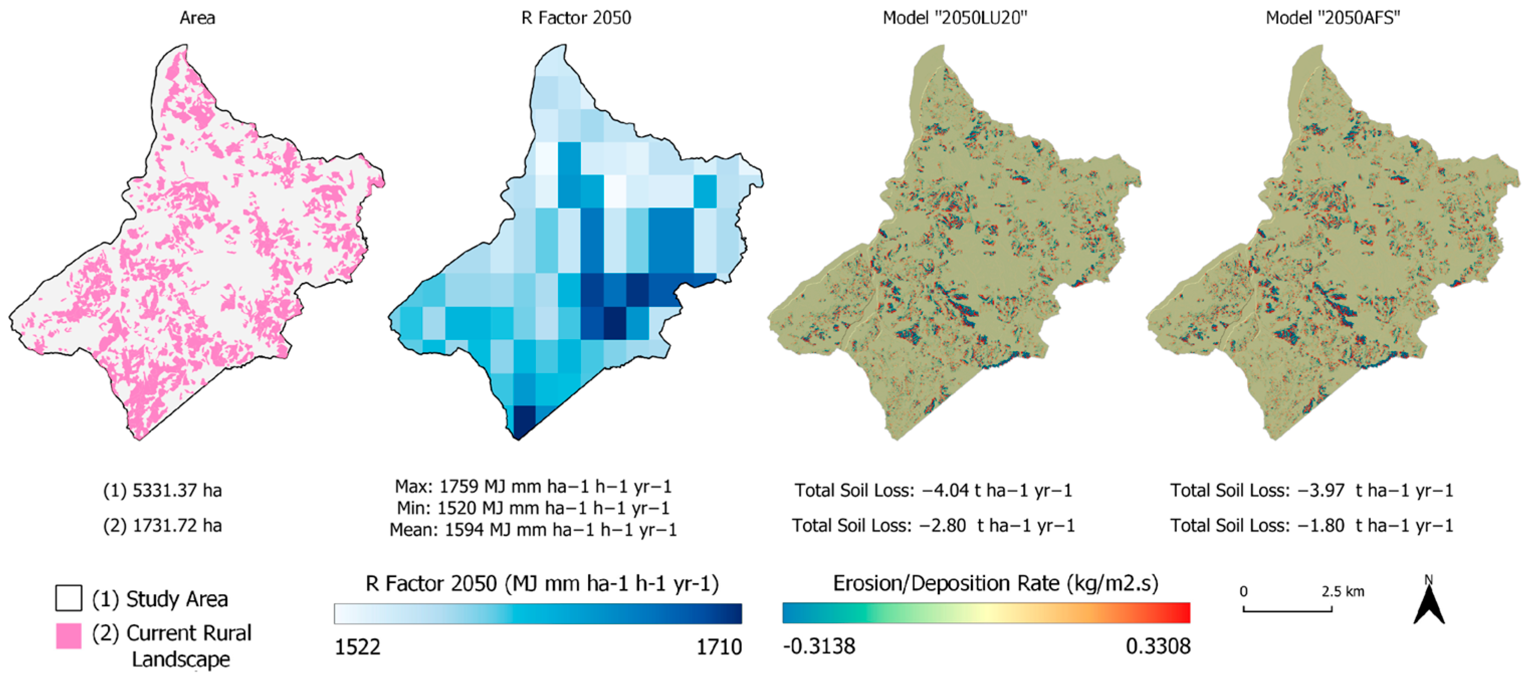
4.2. GIS Modelling of Slope Geomorphic Processes
5. Discussion
6. Conclusions
Supplementary Materials
Author Contributions
Funding
Data Availability Statement
Acknowledgments
Conflicts of Interest
References
- Vanwalleghem, T.; Gómez, J.A.; Infante Amate, J.; González de Molina, M.; Vanderlinden, K.; Guzmán, G.; Laguna, A.; Giráldez, J.V. Impact of Historical Land Use and Soil Management Change on Soil Erosion and Agricultural Sustainability during the Anthropocene. Anthropocene 2017, 17, 13–29. [Google Scholar] [CrossRef]
- Pica, A.; Vergari, F.; Fredi, P.; Del Monte, M. The Aeterna Urbs Geomorphological Heritage (Rome, Italy). Geoheritage 2016, 8, 31–42. [Google Scholar] [CrossRef]
- Brandolini, F.; Cremaschi, M. The Impact of Late Holocene Flood Management on the Central Po Plain (Northern Italy). Sustain. Sci. Pract. Policy 2018, 10, 3968. [Google Scholar] [CrossRef] [Green Version]
- Srivastava, A.; Kinnaird, T.; Sevara, C.; Holcomb, J.A.; Turner, S. Dating Agricultural Terraces in the Mediterranean Using Luminescence: Recent Progress and Challenges. Land 2023, 12, 716. [Google Scholar] [CrossRef]
- Tarolli, P.; Preti, F.; Romano, N. Terraced Landscapes: From an Old Best Practice to a Potential Hazard for Soil Degradation due to Land Abandonment. Anthropocene 2014, 6, 10–25. [Google Scholar] [CrossRef]
- Montanarella, L.; Panagos, P. The Relevance of Sustainable Soil Management within the European Green Deal. Land Use Policy 2021, 100, 104950. [Google Scholar] [CrossRef]
- Schmidt, J.; Usmar, N.; Westphal, L.; Werner, M.; Roller, S.; Rademacher, R.; Kühn, P.; Werther, L.; Kottmann, A. Erosion Modelling Indicates a Decrease in Erosion Susceptibility of Historic Ridge and Furrow Fields near Albershausen, Southern Germany. Land 2023, 12, 544. [Google Scholar] [CrossRef]
- Plieninger, T.; Muñoz-Rojas, J.; Buck, L.E.; Scherr, S.J. Agroforestry for Sustainable Landscape Management. Sustain. Sci. 2020, 15, 1255–1266. [Google Scholar] [CrossRef]
- Zerbe, S. Traditional Cultural Landscapes—A Theoretical Framework. In Restoration of Multifunctional Cultural Landscapes: Merging Tradition and Innovation for a Sustainable Future; Zerbe, S., Ed.; Springer International Publishing: Cham, Switzerland, 2022; pp. 3–17. ISBN 9783030955724. [Google Scholar]
- Joffre, R.; Vacher, J.; de los Llanos, C.; Long, G. The Dehesa: An Agrosilvopastoral System of the Mediterranean Region with Special Reference to the Sierra Morena Area of Spain. Agrofor. Syst. 1988, 6, 71–96. [Google Scholar] [CrossRef]
- Correia, T.P. Threatened Landscape in Alentejo, Portugal: The “montado” and Other “agro-Silvo-Pastoral” Systems. Landsc. Urban Plan. 1993, 24, 43–48. [Google Scholar] [CrossRef]
- Zacharová, J.; Riezner, J.; Elznicová, J.; Machová, I.; Kubát, K.; Holcová, D.; Holec, M.; Pacina, J.; Štojdl, J.; Grygar, T.M. Historical Agricultural Landforms—Central European Bio-Cultural Heritage Worthy of Attention. Land 2022, 11, 963. [Google Scholar] [CrossRef]
- Herzog, F. Streuobst: A Traditional Agroforestry System as a Model for Agroforestry Development in Temperate Europe. Agrofor. Syst. 1998, 42, 61–80. [Google Scholar] [CrossRef]
- Lacerda, A.E.B.; Hanisch, A.L.; Nimmo, E.R. Leveraging Traditional Agroforestry Practices to Support Sustainable and Agrobiodiverse Landscapes in Southern Brazil. Land 2020, 9, 176. [Google Scholar] [CrossRef]
- Lentz, D.L.; Hockaday, B. Tikal Timbers and Temples: Ancient Maya Agroforestry and the End of Time. J. Archaeol. Sci. 2009, 36, 1342–1353. [Google Scholar] [CrossRef]
- Stahl, P.W.; Pearsall, D.M. Late Pre-Columbian Agroforestry in the Tropical Lowlands of Western Ecuador. Quat. Int. 2012, 249, 43–52. [Google Scholar] [CrossRef]
- Souza, J.G.d.; de Souza, J.G.; Robinson, M.; Yoshi Maezumi, S.; Capriles, J.; Hoggarth, J.A.; Lombardo, U.; Novello, V.F.; Apaéstegui, J.; Whitney, B.; et al. Climate Change and Cultural Resilience in Late Pre-Columbian Amazonia. Nat. Ecol. Evol. 2019, 3, 1007–1017. [Google Scholar] [CrossRef]
- Augère-Granier, M.-L. Agroforestry in the European Union; European Parliamentary Research Service: Brussels, Belgium, 2020.
- Nair, P.K.R.; Kumar, B.M.; Nair, V.D. Carbon Sequestration and Climate Change Mitigation. In An Introduction to Agroforestry: Four Decades of Scientific Developments; Nair, P.K.R., Kumar, B.M., Nair, V.D., Eds.; Springer International Publishing: Cham, Switzerland, 2021; pp. 487–537. ISBN 9783030753580. [Google Scholar]
- Kay, S.; Rega, C.; Moreno, G.; den Herder, M.; Palma, J.H.N.; Borek, R.; Crous-Duran, J.; Freese, D.; Giannitsopoulos, M.; Graves, A.; et al. Agroforestry Creates Carbon Sinks Whilst Enhancing the Environment in Agricultural Landscapes in Europe. Land Use Policy 2019, 83, 581–593. [Google Scholar] [CrossRef]
- Brunori, E.; Maesano, M.; Moresi, F.V.; Matteucci, G.; Biasi, R.; Scarascia Mugnozza, G. The Hidden Land Conservation Benefits of Olive-based (Olea Europaea L.) Landscapes: An Agroforestry Investigation in the Southern Mediterranean (Calabria Region, Italy). Land Degrad. Dev. 2020, 31, 801–815. [Google Scholar] [CrossRef]
- Purwaningsih, R.; Sartohadi, J.; Setiawan, M.A. Trees and Crops Arrangement in the Agroforestry System Based on Slope Units to Control Landslide Reactivation on Volcanic Foot Slopes in Java, Indonesia. Land 2020, 9, 327. [Google Scholar] [CrossRef]
- Hairiah, K.; Widianto, W.; Suprayogo, D.; Van Noordwijk, M. Tree Roots Anchoring and Binding Soil: Reducing Landslide Risk in Indonesian Agroforestry. Land 2020, 9, 256. [Google Scholar] [CrossRef]
- Nair, P.K.R.; Kumar, B.M.; Nair, V.D. Soil Conservation and Control of Land-Degradation. In An Introduction to Agroforestry: Four Decades of Scientific Developments; Nair, P.K.R., Kumar, B.M., Nair, V.D., Eds.; Springer International Publishing: Cham, Switzerland, 2021; pp. 445–474. ISBN 9783030753580. [Google Scholar]
- Foster, G.R.; Young, R.A.; Römkens, M.J.M.; Onstad, C.A. Processes of Soil Erosion by Water. In Soil Erosion and Crop Productivity; American Society of Agronomy, Crop Science Society of America, Soil Science Society of America: Madison, WI, USA, 2015; pp. 137–162. ISBN 9780891182511. [Google Scholar]
- Bollati, I.; Reynard, E.; Palmieri, E.L.; Pelfini, M. Runoff Impact on Active Geomorphosites in Unconsolidated Substrate. A Comparison Between Landforms in Glacial and Marine Clay Sediments: Two Case Studies from the Swiss Alps and the Italian Apennines. Geoheritage 2016, 8, 61–75. [Google Scholar] [CrossRef]
- Bollati, I.M.; Masseroli, A.; Mortara, G.; Pelfini, M.; Trombino, L. Alpine Gullies System Evolution: Erosion Drivers and Control Factors. Two Examples from the Western Italian Alps. Geomorphology 2019, 327, 248–263. [Google Scholar] [CrossRef]
- Crosta, G.B.; Frattini, P. Rainfall-Induced Landslides and Debris Flows. Hydrol. Process. 2008, 22, 473–477. [Google Scholar] [CrossRef]
- Geertsema, M.; Highland, L.; Vaugeouis, L. Environmental Impact of Landslides. In Landslides—Disaster Risk Reduction; Sassa, K., Canuti, P., Eds.; Springer: Berlin/Heidelberg, Germany, 2009; pp. 589–607. ISBN 9783540699705. [Google Scholar]
- Kjekstad, O.; Highland, L. Economic and Social Impacts of Landslides. In Landslides—Disaster Risk Reduction; Sassa, K., Canuti, P., Eds.; Springer: Berlin/Heidelberg, Germany, 2009; pp. 573–587. ISBN 9783540699705. [Google Scholar]
- Canuti, P.; Casagli, N.; Catani, F.; Fanti, R. Hydrogeological Hazard and Risk in Archaeological Sites: Some Case Studies in Italy. J. Cult. Herit. 2000, 1, 117–125. [Google Scholar] [CrossRef]
- Masseroli, A.; Bollati, I.M.; Trombino, L.; Pelfini, M. The Soil Trail of Buscagna Valley, an Example of the Role of Soil Science in Geodiversity and Geoheritage Analyses. In Visages of Geodiversity and Geoheritage; Kubalíková, L., Coratza, P., Pál, M., Zwoliński, Z., Irapta, P.N., Wyk de Vries, B., Eds.; Special Publications; Geological Society: London, UK, 2023; Volume 530. [Google Scholar]
- Borrelli, P.; Robinson, D.A.; Panagos, P.; Lugato, E.; Yang, J.E.; Alewell, C.; Wuepper, D.; Montanarella, L.; Ballabio, C. Land Use and Climate Change Impacts on Global Soil Erosion by Water (2015–2070). Proc. Natl. Acad. Sci. USA 2020, 117, 21994–22001. [Google Scholar] [CrossRef]
- Jaedicke, C.; Van Den Eeckhaut, M.; Nadim, F.; Hervás, J.; Kalsnes, B.; Vangelsten, B.V.; Smith, J.T.; Tofani, V.; Ciurean, R.; Winter, M.G.; et al. Identification of Landslide Hazard and Risk “hotspots” in Europe. Bull. Eng. Geol. Environ. 2014, 73, 325–339. [Google Scholar] [CrossRef] [Green Version]
- Papa, G.L.; Dazzi, C.; Némethy, S.; Corti, G.; Cocco, S. Land Set-up Systems in Italy: A Long Tradition of Soil and Water Conservation Sewed up to a Variety of Pedo-Climatic Environments. Ital. J. Agron. 2020, 15, 281–292. [Google Scholar] [CrossRef]
- Salvatico, A. L’economia Dell’alteno: Viticoltura e Cerealicoltura nel Roero e Nelle Langhe tra il Basso Medioevo e la Prima età Moderna; Marco Valerio Editore: Turin, Italy, 2004; ISBN 9788888132266. [Google Scholar]
- Paris, P.; Camilli, F.; Rosati, A.; Mantino, A.; Mezzalira, G.; Dalla Valle, C.; Franca, A.; Seddaiu, G.; Pisanelli, A.; Lauteri, M.; et al. What Is the Future for Agroforestry in Italy? Agrofor. Syst. 2019, 93, 2243–2256. [Google Scholar] [CrossRef] [Green Version]
- Ferrario, V. Learning from Agricultural Heritage? Lessons of Sustainability from Italian “Coltura Promiscua”. Sustain. Sci. Pract. Policy 2021, 13, 8879. [Google Scholar] [CrossRef]
- Montrasio, L.; Valentino, R.; Losi, G.L. Shallow Landslides Triggered by Rainfalls: Modeling of Some Case Histories in the Reggiano Apennine (Emilia Romagna Region, Northern Italy). Nat. Hazards 2012, 60, 1231–1254. [Google Scholar] [CrossRef]
- Olsson, L.; Barbosa, H.; Bhadwal, S.; Cowie, A.; Delusca, K.; Flores-Renteria, D.; Hermans, K.; Jobbagy, E.; Kurz, W.; Li, D.; et al. Land Degradation. In Climate Change and Land: An IPCC Special Report on Climate Change, Desertification, Land Degradation, Sustainable Land Management, Food Security, and Greenhouse Gas Fluxes in Terrestrial Ecosystems; Shukla, P.R., Skea, J., Calvo Buendia, E., Masson-Delmotte, V., Pörtner, H., Roberts, D.C., Zhai, P., Malley, J., Eds.; Intergovernmental Panel on Climate Change (IPCC): Geneva, Switzerland, 2019. [Google Scholar]
- Panagos, P.; Ballabio, C.; Himics, M.; Scarpa, S.; Matthews, F.; Bogonos, M.; Poesen, J.; Borrelli, P. Projections of Soil Loss by Water Erosion in Europe by 2050. Environ. Sci. Policy 2021, 124, 380–392. [Google Scholar] [CrossRef]
- Pieri, L.; Bittelli, M.; Wu, J.Q.; Dun, S.; Flanagan, D.C.; Pisa, P.R.; Ventura, F.; Salvatorelli, F. Using the Water Erosion Prediction Project (WEPP) Model to Simulate Field-Observed Runoff and Erosion in the Apennines Mountain Range, Italy. J. Hydrol. 2007, 336, 84–97. [Google Scholar] [CrossRef]
- Guerra, V.; Lazzari, M. Geomorphic Approaches to Estimate Short-Term Erosion Rates: An Example from Valmarecchia River System (Northern Apennines, Italy). Water 2020, 12, 2535. [Google Scholar] [CrossRef]
- Ghosal, K.; Das Bhattacharya, S. A Review of RUSLE Model. J. Indian Soc. Remote Sens. 2020, 48, 689–707. [Google Scholar] [CrossRef]
- Borrelli, P.; Märker, M.; Panagos, P.; Schütt, B. Modeling Soil Erosion and River Sediment Yield for an Intermountain Drainage Basin of the Central Apennines, Italy. Catena 2014, 114, 45–58. [Google Scholar] [CrossRef]
- Borrelli, P.; Märker, M.; Schütt, B. Modelling Post-Tree-Harvesting Soil Erosion and Sediment Deposition Potential in the Turano River Basin (Italian Central Apennine). Land Degrad. Dev. 2015, 26, 356–366. [Google Scholar] [CrossRef]
- Brandolini, F.; Kinnaird, T.C.; Srivastava, A.; Turner, S. Modelling the Impact of Historic Landscape Change on Soil Erosion and Degradation. Sci. Rep. 2023, 13, 4949. [Google Scholar] [CrossRef]
- Brandolini, F.; Turner, S. Revealing Patterns and Connections in the Historic Landscape of the Northern Apennines (Vetto, Italy). J. Maps 2022, 18, 663–673. [Google Scholar] [CrossRef]
- Mariani, G.S.; Brandolini, F.; Pelfini, M.; Zerboni, A. Matilda’s Castles, Northern Apennines: Geological and Geomorphological Constrains. J. Maps 2019, 15, 521–529. [Google Scholar] [CrossRef]
- Kottek, M.; Grieser, J.; Beck, C.; Rudolf, B.; Rubel, F. World Map of the Köppen-Geiger Climate Classification Updated. Meteorol. Z. 2006, 15, 259–263. [Google Scholar] [CrossRef]
- Haller, A.; Bender, O. Among Rewilding Mountains: Grassland Conservation and Abandoned Settlements in the Northern Apennines. Landsc. Res. 2018, 43, 1068–1084. [Google Scholar] [CrossRef] [Green Version]
- Bini, C. Geology and Geomorphology. In The Soils of Italy; Costantini, E.A.C., Dazzi, C., Eds.; Springer: Dordrecht, The Netherlands, 2013; pp. 39–56. ISBN 9789400756427. [Google Scholar]
- Piacentini, D.; Troiani, F.; Daniele, G.; Pizziolo, M. Historical Geospatial Database for Landslide Analysis: The Catalogue of Landslide OCcurrences in the Emilia-Romagna Region (CLOCkER). Landslides 2018, 15, 811–822. [Google Scholar] [CrossRef]
- Geoportale ER. Available online: https://geoportale.regione.emilia-romagna.it/ (accessed on 12 February 2023).
- Sereni, E. Storia del Paesaggio Agrario Italiano; Editori Laterza: Bari, Italy, 1961. [Google Scholar]
- Tanara, V. L’economia del Cittadino in Villa, del Signor Vincenzo Tanara Libri 7. Riueduta, ed Accresciuta in Molto Luoghi dal Medesimo Auttore, con L’aggiunta delle Qualita del Cacciatore; Appresso Bortolo Zerletti: Venezia, Italy, 1713. [Google Scholar]
- Re, F. Viaggio Agronomico per la Montagna Reggiana E Dei Mezzi Di Migliorare L’agricoltura Delle Montagne Reggiane; Casali, C., Ed.; Officine Grafiche Reggiane: Reggio Emilia, Italy, 1927. [Google Scholar]
- Wheatley, D.; Gillings, M. Spatial Technology and Archaeology: The Archaeological Applications of GIS; CRC Press: Boca Raton, FL, USA, 2013; ISBN 9781466576612. [Google Scholar]
- Brandolini, F.; Domingo-Ribas, G.; Zerboni, A.; Turner, S. A Google Earth Engine-Enabled Python Approach to Improve Identification of Anthropogenic Palaeo-Landscape Features. Open Res. Eur. 2021, 1, 22. [Google Scholar] [CrossRef]
- Otto, J.-C.; Prasicek, G.; Blöthe, J.; Schrott, L. 2.05—GIS Applications in Geomorphology. In Comprehensive Geographic Information Systems; Huang, B., Ed.; Elsevier: Oxford, UK, 2018; pp. 81–111. ISBN 9780128047934. [Google Scholar]
- Steiniger, S.; Hay, G.J. Free and Open Source Geographic Information Tools for Landscape Ecology. Ecol. Inform. 2009, 4, 183–195. [Google Scholar] [CrossRef]
- Turner, S.; Shillito, L.-M.; Carrer, F. Landscape Archaeology. In The Routledge Companion to Landscape Studies; Howard, P., Thompson, I., Waterton, E., Atha, M., Eds.; Routledge: London, UK, 2018; pp. 155–165. [Google Scholar]
- Dabaut, N.; Carrer, F. Historic LAndscape CHaracterisation: Technical Approaches beyond Theory. Landscapes 2020, 21, 152–167. [Google Scholar] [CrossRef]
- Turner, S. Historic Landscape Characterisation: An Archaeological Approach to Landscape Heritage. In Routledge Handbook of Landscape Character Assessment; Routledge: London, UK, 2018; pp. 37–50. [Google Scholar]
- Geoportale ER. Database Uso Del Suolo. Available online: https://geoportale.regione.emilia-romagna.it/approfondimenti/database-uso-del-suolo (accessed on 4 April 2023).
- Yutzler, J.; Daise, P. OGC®—GeoPackage Encoding Standard. 2021. Available online: https://portal.ogc.org/files/?artifact_id=74225 (accessed on 8 May 2023).
- NextGIS. QuickMapServices. Available online: https://nextgis.com/blog/quickmapservices/ (accessed on 3 March 2019).
- QGIS Development Team. QGIS Geographic Information System; Open Source Geospatial Foundation Project. 2023. Available online: https://qgis.org/en/site/ (accessed on 8 May 2023).
- CTR. Available online: https://geoportale.regione.emilia-romagna.it/catalogo/dati-cartografici/cartografia-di-base/cartografia-tecnica/layer-1 (accessed on 23 June 2021).
- CGR. Available online: https://geoportale.regione.emilia-romagna.it/catalogo/dati-cartografici/cartografia-di-base/immagini/layer-4 (accessed on 23 June 2021).
- AGEA. Available online: https://geoportale.regione.emilia-romagna.it/catalogo/dati-cartografici/cartografia-di-base/immagini/layer-2 (accessed on 23 June 2021).
- AGEA. Available online: https://geoportale.regione.emilia-romagna.it/catalogo/dati-cartografici/cartografia-di-base/immagini/layer-3 (accessed on 23 June 2021).
- CGRA. Available online: https://www.provincia.re.it/aree-tematiche/pianificazione-territoriale/sistema-informativo-territoriale/archivio-cartografico/foto-aeree/volo-cgra-1976-78-scala-113-500/ (accessed on 23 June 2021).
- USGS. EROS Archive—Declassified Data—Declassified Satellite Imagery-3. Available online: https://www.usgs.gov/centers/eros/science/usgs-eros-archive-declassified-data-declassified-satellite-imagery-3 (accessed on 13 December 2021).
- IGM. Available online: https://www.igmi.org/ (accessed on 11 July 2021).
- Nuovo Catasto Terreni. Available online: https://www.provincia.re.it/aree-tematiche/pianificazione-territoriale/sistema-informativo-territoriale/archivio-cartografico/cartografia-storica/carta-catastale-di-impianto-della-provincia-di-reggio-emilia-scala-12-000-11-000-edizione-fine-xix-secolo/ (accessed on 4 January 2021).
- Carta Storica Regionale. Available online: https://geoportale.regione.emilia-romagna.it/catalogo/dati-cartografici/cartografia-di-base/cartografia-storica/layer-1 (accessed on 4 January 2021).
- Timár, G.; Molnár, G.; Székely, B.; Biszak, S.; Varga, J.; Jankó, A. Digitized Maps of the Habsburg Empire—The Map Sheets of the Second Military Survey and Their Georeferenced Version; Arcanum: Budapest, Hungary, 2006; ISBN 9789637374333. [Google Scholar]
- Ostafin, K.; Pietrzak, M.; Kaim, D. Impact of the Cartographer’s Position and Topographic Accessibility on the Accuracy of Historical Land Use Information: Case of the Second Military Survey Maps of the Habsburg Empire. ISPRS Int. J. Geo-Inf. 2021, 10, 820. [Google Scholar] [CrossRef]
- Guida, D.; Pelfini, M.; Santilli, M. Geomorphological and Dendrochronological Analyses of a Complex Landslide in the Southern Apennines. Geogr. Ann. Ser. A Phys. Geogr. 2008, 90, 211–226. [Google Scholar] [CrossRef]
- Bollati, I.; Vergari, F.; Del Monte, M.; Pelfini, M. Multitemporal Dendrogeomorphological Analysis of Slope Instability in Upper Orcia Valley (Southern Tuscany, Italy). Geogr. Fis. Din. Quat. 2016, 39, 105–120. [Google Scholar]
- Gebrekirstos, A.; Bräuning, A.; Sass-Klassen, U.; Mbow, C. Opportunities and Applications of Dendrochronology in Africa. Curr. Opin. Environ. Sustain. 2014, 6, 48–53. [Google Scholar] [CrossRef] [Green Version]
- Tronti, G.; Vergari, F.; Bollati, I.M.; Belisario, F.; Del Monte, M.; Pelfini, M.; Fredi, P. From Landslide Characterization to Nature Reserve Management: The “Scialimata Grande Di Torre Alfina” Landslide Geosite (Central Apennines, Italy). J. Mt. Sci. 2023, 20, 585–606. [Google Scholar] [CrossRef]
- Grissino-Mayer, H.D. A Manual and Tutorial for the Proper Use of an Increment Borer. Tree-Ring Res. 2003, 59, 63–79. [Google Scholar]
- GRASS Development Team. Geographic Resources Analysis Support System (GRASS); Open Source Geospatial Foundation: Beaverton, OR, USA, 2023. [Google Scholar]
- Mitasova, H.; Michael Barton, C.; Ullah, I.; Hofierka, J.; Harmon, R.S. 3.9 GIS-Based Soil Erosion Modeling. In Treatise in Geomorphology: Vol. 3 Remote Sensing and GI Science in Geomorpholog; Shroder, J.F., Ed.; Academic Press: San Diego, CA, USA, 2013; Volume 3, pp. 228–258. ISBN 9780080885223. [Google Scholar]
- Panagos, P.; Borrelli, P.; Meusburger, K.; Alewell, C.; Lugato, E.; Montanarella, L. Estimating the Soil Erosion Cover-Management Factor at the European Scale. Land Use Policy 2015, 48, 38–50. [Google Scholar] [CrossRef]
- Ullah, I.; Barton, M.; Mitasova, H. r.landscape.evol. 2023. Available online: https://grass.osgeo.org/grass82/manuals/addons/r.landscape.evol.html (accessed on 8 May 2023).
- Encyclopedia Britannica. The Editors of Encyclopedia Britannica Momentum. 2022. Available online: https://www.britannica.com/science/momentum (accessed on 8 May 2023).
- Soil Erosion (1:50k) Map—Emilia Romagna Region. Available online: https://mappegis.regione.emilia-romagna.it/gstatico/documenti/dati_pedol/download/erosione_idrica_2019_raster.zip (accessed on 1 November 2022).
- Panagos, P.; Borrelli, P.; Matthews, F.; Liakos, L.; Bezak, N.; Diodato, N.; Ballabio, C. Global Rainfall Erosivity Projections for 2050 and 2070. J. Hydrol. 2022, 610, 127865. [Google Scholar] [CrossRef]
- Lelle, M.A.; Gold, M.A. Agroforestry Systems for Temperate Climates: Lessons from Roman Italy. For. Conserv. Hist. 1994, 38, 118–126. [Google Scholar] [CrossRef]
- Rombaldi, O. Dalla Mezzadria Nel Reggiano, a Proposito Del Saggio Sopra La Storia dell’Agricoltura Di Filippo Re. Riv. Stor. Dell’agricoltura 1965, 5, 22–48. [Google Scholar]
- Cingolani, G. L’Italia Delle Colline. In Storia e Problemi Contemporanei; CLUEB: Bologna, Italy, 2004; pp. 1–7. [Google Scholar]
- Montanari, M. Colture, lavori, tecniche, rendimenti. In Storia Dell’agricoltura Italiana—IL Medioevo E L’età Moderna; Pinto, G., Poni, C., Tucci, U., Eds.; Polistampa: San Fermo Della Battaglia, Italy, 2010; Volume 2, pp. 59–82. ISBN 9788859607656. [Google Scholar]
- Piccinni, G. La proprietà della terra, i percettori dei prodotti e della rendita. In Storia Dell’agricoltura Italiana—IL Medioevo E L’età Moderna; Pinto, G., Poni, C., Tucci, U., Eds.; Polistampa: San Fermo Della Battaglia, Italy, 2010; Volume 2, pp. 145–170. ISBN 9788859607656. [Google Scholar]
- Cafasi, F. L’agricoltura Negli Stati Estensi Nel Periodo Pre-Unitario. Riv. Stor. Dell’agricoltura 1980, XX, 79–94. [Google Scholar]
- Cazzola, F. Verso la centralità del frumento. In Storia Dell’agricoltura Italiana—IL Medioevo E L’età Moderna; Pinto, G., Poni, C., Tucci, U., Eds.; Polistampa: San Fermo Della Battaglia, Italy, 2010; Volume 2, pp. 223–254. ISBN 9788859607656. [Google Scholar]
- Rombai, L.; Bomcompagni, A. Popolazione, popolamento, sistemi colturali, spazi coltivati, aree boschive ed incolte. In Storia Dell’agricoltura Italiana—IL MEDIOEVO E L’ETÀ MODERNA; Pinto, G., Poni, C., Tucci, U., Eds.; Polistampa: San Fermo Della Battaglia, Italy, 2010; Volume 2, pp. 171–222. ISBN 9788859607656. [Google Scholar]
- Nair, P.K.R.; Kumar, B.M.; Nair, V.D. Agroforestry Systems in The Temperate Zone. In An Introduction to Agroforestry: Four Decades of Scientific Developments; Nair, P.K.R., Kumar, B.M., Nair, V.D., Eds.; Springer International Publishing: Cham, Switzerland, 2021; pp. 195–232. ISBN 9783030753580. [Google Scholar]
- Assini, S.; Filipponi, F.; Zucca, F. Land Cover Changes in an Abandoned Agricultural Land in the Northern Apennine (Italy) between 1954 and 2008: Spatio-Temporal Dynamics. Plant Biosyst.—Int. J. Deal. All Asp. Plant Biol. 2015, 149, 807–817. [Google Scholar] [CrossRef]
- Argenti, G.; Parrini, S.; Staglianò, N.; Bozzi, R. Evolution of Production and Forage Quality in Sown Meadows of a Mountain Area inside Parmesan Cheese Consortium. Agron. Res. 2021, 19, 344–356. [Google Scholar]
- EAFRD. Rural Development Programmes 2014–2020: Key Facts & Figures; European Agricultural Fund for Rural Development. 2014. Available online: https://ec.europa.eu/enrd/sites/default/files/priority-4-summary.pdf (accessed on 8 May 2023).
- Bando Montagna. 2022. Available online: https://tinyurl.com/yr5m6cxz (accessed on 1 November 2022).
- Karcagi Kováts, A.; Katona Kovács, J. Factors of population decline in rural areas and answers given in EU member states’ strategies. Food Res. Inst. Stud. Agric. Econ. Trade Dev. 2012, 114, 49–56. [Google Scholar]
- European Commission. Horizon Europe Strategic Plan (2021–2024); European Commission Directorate-General for Research and Innovation: Brussels, Belgium, 2021. [Google Scholar]
- EIP-AGRI. Workshop Towards Carbon Neutral Agriculture Workshop Report 24–25 March 2021; The Agricultural European Innovation Partnership: Brussels, Belgium, 2021. [Google Scholar]
- Berger-Tal, O.; Saltz, D. Invisible Barriers: Anthropogenic Impacts on Inter- and Intra-Specific Interactions as Drivers of Landscape-Independent Fragmentation. Philos. Trans. R. Soc. Lond. B Biol. Sci. 2019, 374, 20180049. [Google Scholar] [CrossRef] [Green Version]
- Sutor, S.; McIntyre, N.E.; Griffis-Kyle, K. Characterizing Range-Wide Impacts of Anthropogenic Barriers on Structural Landscape Connectivity for the Sonoran Desert Tortoise (Gopherus Morafkai). Landsc. Ecol. 2023, 4, 118–126. [Google Scholar] [CrossRef]
- Rippa, D.; Maselli, V.; Soppelsa, O.; Fulgione, D. The Impact of Agro-Pastoral Abandonment on the Rock Partridge Alectoris Graeca in the Apennines. IBIS 2011, 153, 721–734. [Google Scholar] [CrossRef]
- Haggar, J.; Pons, D.; Saenz, L.; Vides, M. Contribution of Agroforestry Systems to Sustaining Biodiversity in Fragmented Forest Landscapes. Agric. Ecosyst. Environ. 2019, 283, 106567. [Google Scholar] [CrossRef]
- Bentrup, G.; Hopwood, J.; Adamson, N.L.; Vaughan, M. Temperate Agroforestry Systems and Insect Pollinators: A Review. Forests 2019, 10, 981. [Google Scholar] [CrossRef] [Green Version]
- Santiago-Freijanes, J.J.; Mosquera-Losada, M.R.; Rois-Díaz, M.; Ferreiro-Domínguez, N.; Pantera, A.; Aldrey, J.A.; Rigueiro-Rodríguez, A. Global and European Policies to Foster Agricultural Sustainability: Agroforestry. Agrofor. Syst. 2021, 95, 775–790. [Google Scholar] [CrossRef]
- Messean; Viguier; Paresys Enabling Crop Diversification to Support Transitions towards More Sustainable European Agrifood Systems. Front. Agric. Sci. Eng. 2021, 8, 474–480.
- Tress, B.; Tress, G.; van der Valk, A.; Fry, G. Interdisciplinary and Transdisciplinary Landscape Studies: Potential and Limitations; Delta Program: Wageningen, The Netherlands, 2003. [Google Scholar]
- Piacente, S.; Badiali, F. La Ricerca Transdisciplinare per La Conoscenza E La Valorizzazione Del Territorio. Ric. Transdiscipl. Conosc. Valoriz. Territ. 2019, 1, 105–116. [Google Scholar]
- Turner, S.; Kinnaird, T.; Koparal, E.; Lekakis, S.; Sevara, C. Landscape Archaeology, Sustainability and the Necessity of Change. World Archaeol. 2020, 52, 589–606. [Google Scholar] [CrossRef]
- Brandolini, F. Tecniche Digitali e Geoarcheologia per lo Studio del Paesaggio Medievale: Uno Studio Interdisciplinare in Pianura Padana Centrale; British Archaeological Reports Limited: Oxford, UK, 2021; ISBN 9781407358543. [Google Scholar]
- Zerbe, S. Merging Traditions and Innovation for Sustainability and Multifunctionality of Cultural Landscapes. In Restoration of Multifunctional Cultural Landscapes: Merging Tradition and Innovation for a Sustainable Future; Zerbe, S., Ed.; Springer International Publishing: Cham, Switzerland, 2022; pp. 497–513. ISBN 9783030955724. [Google Scholar]
- Ganasri, B.P.; Ramesh, H. Assessment of Soil Erosion by RUSLE Model Using Remote Sensing and GIS—A Case Study of Nethravathi Basin. Geosci. Front. 2016, 7, 953–961. [Google Scholar] [CrossRef] [Green Version]
- Alewell, C.; Borrelli, P.; Meusburger, K.; Panagos, P. Using the USLE: Chances, Challenges and Limitations of Soil Erosion Modelling. Int. Soil Water Conserv. Res. 2019, 7, 203–225. [Google Scholar] [CrossRef]


| Name | Publication | Type | Scale | Source |
|---|---|---|---|---|
| Google© Satellite | 2022 | Satellite images | - | QuickMapServices plugin [67] in QGIS 3.22 [68] |
| Bing© Satellite | 2022 | Satellite images | - | QuickMapServices plugin [67] in QGIS 3.22 [68] |
| Carta Tecnica Regionale (CTR) | 2018 | Cadastral map | 1:5000 | WMS service [69] |
| Compagnia Generale Riprese (CGR) Aeree | 2018 | Aerial photos | - | WMS service [70] |
| AGEA (Agenzia per le Erogazioni in Agricoltura) 11 | 2011 | Aerial photos | - | WMS service [71] |
| AGEA (Agenzia per le Erogazioni in Agricoltura) 08 | 2008 | Aerial photos | - | WMS service [72] |
| Volo Compagnia Generale Riprese Aeree (CGRA) | 1976–1978 | Aerial photos | 1:13,500 | Photos retrieved at the Ufficio cartografico della Provincia di Reggio Emilia [73] |
| KH-9 (Hexagon) | 1974 | Satellite images | - | Declassified image retrieved at the US Geological Survey website [74] |
| Volo GAI (Gruppo Aereo Italiano) | 1954–1955 | Aerial photos | 1:33,000 | Photos retrieved at the Istituto Geografico Militare (IGM) website [75] |
| Nuovo Catasto Terreni | 1886–1900 | Cadastral map | 1:2000 | Map retrieved at the Ufficio cartografico della Provincia di Reggio Emilia [76] |
| Carta Storica Regionale Emilia Romagna | 1853 | Historical map | 1:50,000 | WMS service [77] |
| Second military survey of the Habsburg Empire | 1818–1829 | Historical map | 1:28,800 | Map retrieved at the Mapire website [78,79] |
| Viaggio Agronomico per La Montagna Reggiana E Dei Mezzi Di Migliorare L’agricoltura Delle Montagne Reggiane | 1800 | Historic document | - | [57] |
| L’economia del cittadino in villa, del signor Vincenzo Tanara libri 7. Riueduta, ed accresciuta in molto luoghi dal medesimo auttore, con l’aggiunta delle qualita del cacciatore | 1713 | Historic document | - | [56] |
| Land Use Type | Model “1950” | Model “2020” | Model “AFS” | |||
|---|---|---|---|---|---|---|
| Area (ha) | Soil Loss (t·ha−1·year−1) | Area (ha) | Soil Loss (t·ha−1·year−1) | Area (ha) | Soil Loss (t·ha−1·year−1) | |
| Agroforestry | 1024.83 | 0.93 | 5.66 | 0.02 | 1730.15 | −1.54 |
| Arable land | 1220.20 | −4.65 | 657.00 | −1.55 | nd | nd |
| Grassland | 253.66 | 0.63 | 1067.49 | −0.89 | nd | nd |
| Rough ground | 190.02 | −3.29 | 190.74 | −6.50 | 190.74 | −6.55 |
| Urban area | 65.24 | −0.28 | 184.26 | −0.45 | 184.26 | −0.30 |
| Woodland | 2577.43 | 2.86 | 3226.22 | 5.90 | 3226.22 | 4.98 |
| Total | 5331.37 | −3.80 | 5331.37 | −3.47 | 5331.37 | −3.41 |
Disclaimer/Publisher’s Note: The statements, opinions and data contained in all publications are solely those of the individual author(s) and contributor(s) and not of MDPI and/or the editor(s). MDPI and/or the editor(s) disclaim responsibility for any injury to people or property resulting from any ideas, methods, instructions or products referred to in the content. |
© 2023 by the authors. Licensee MDPI, Basel, Switzerland. This article is an open access article distributed under the terms and conditions of the Creative Commons Attribution (CC BY) license (https://creativecommons.org/licenses/by/4.0/).
Share and Cite
Brandolini, F.; Compostella, C.; Pelfini, M.; Turner, S. The Evolution of Historic Agroforestry Landscape in the Northern Apennines (Italy) and Its Consequences for Slope Geomorphic Processes. Land 2023, 12, 1054. https://doi.org/10.3390/land12051054
Brandolini F, Compostella C, Pelfini M, Turner S. The Evolution of Historic Agroforestry Landscape in the Northern Apennines (Italy) and Its Consequences for Slope Geomorphic Processes. Land. 2023; 12(5):1054. https://doi.org/10.3390/land12051054
Chicago/Turabian StyleBrandolini, Filippo, Chiara Compostella, Manuela Pelfini, and Sam Turner. 2023. "The Evolution of Historic Agroforestry Landscape in the Northern Apennines (Italy) and Its Consequences for Slope Geomorphic Processes" Land 12, no. 5: 1054. https://doi.org/10.3390/land12051054