


A Study on the Advancement of Spatial Maps and the Improvement of the Legal System as a Key Tool for Sustainable National Landscape Planning: Case Study of South Korea
Abstract
:1. Introduction
2. Data and Methods
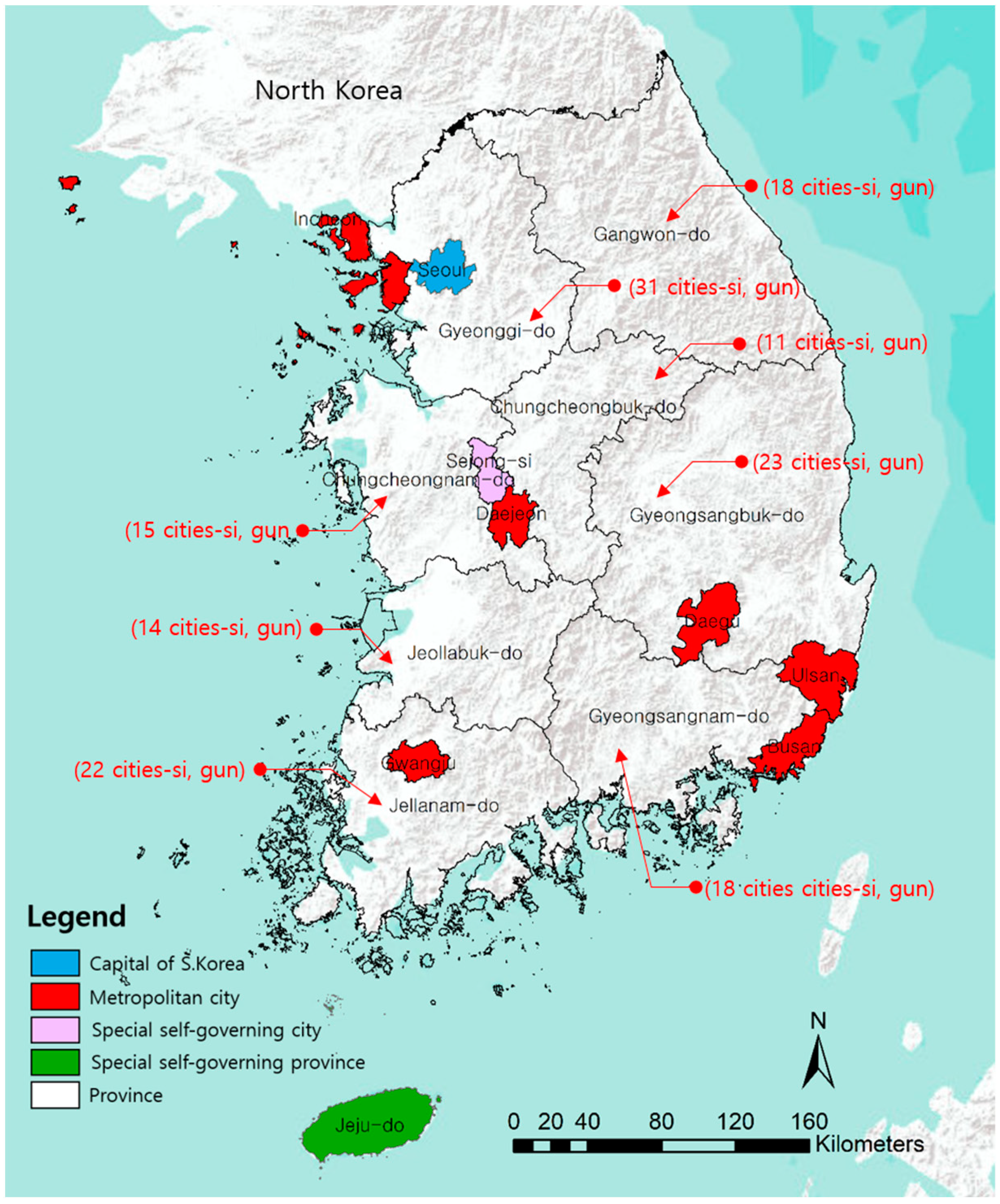
2.1. Scope of Research
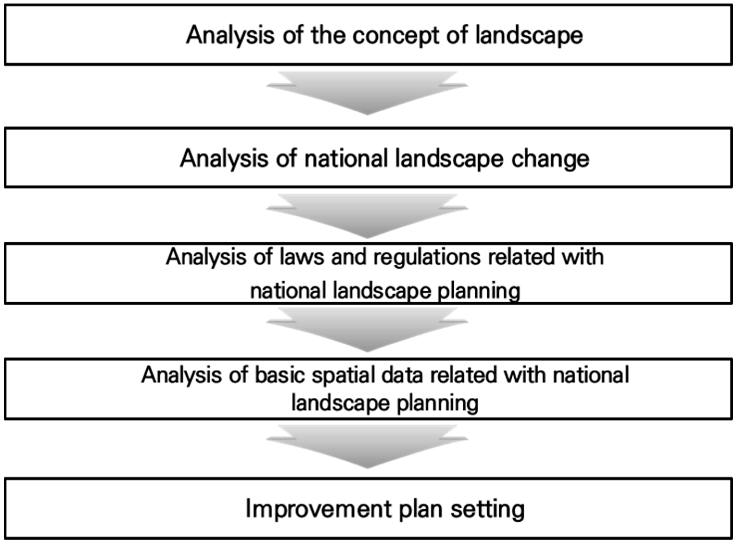
2.2. Procedure for Conducting the Study
2.3. Analysis of the Concept of Landscape
2.4. Changes in Korea’s Landscape over the Past 30 Years
2.5. Content of Landscape Planning within the Legal System Related to National Landscape Planning
2.6. Basic Spatial Maps Related to National Landscape Planning
3. Results
3.1. Analysis of the Concept of Landscape
3.2. Changes in Korea’s Landscape over the Past 30 Years
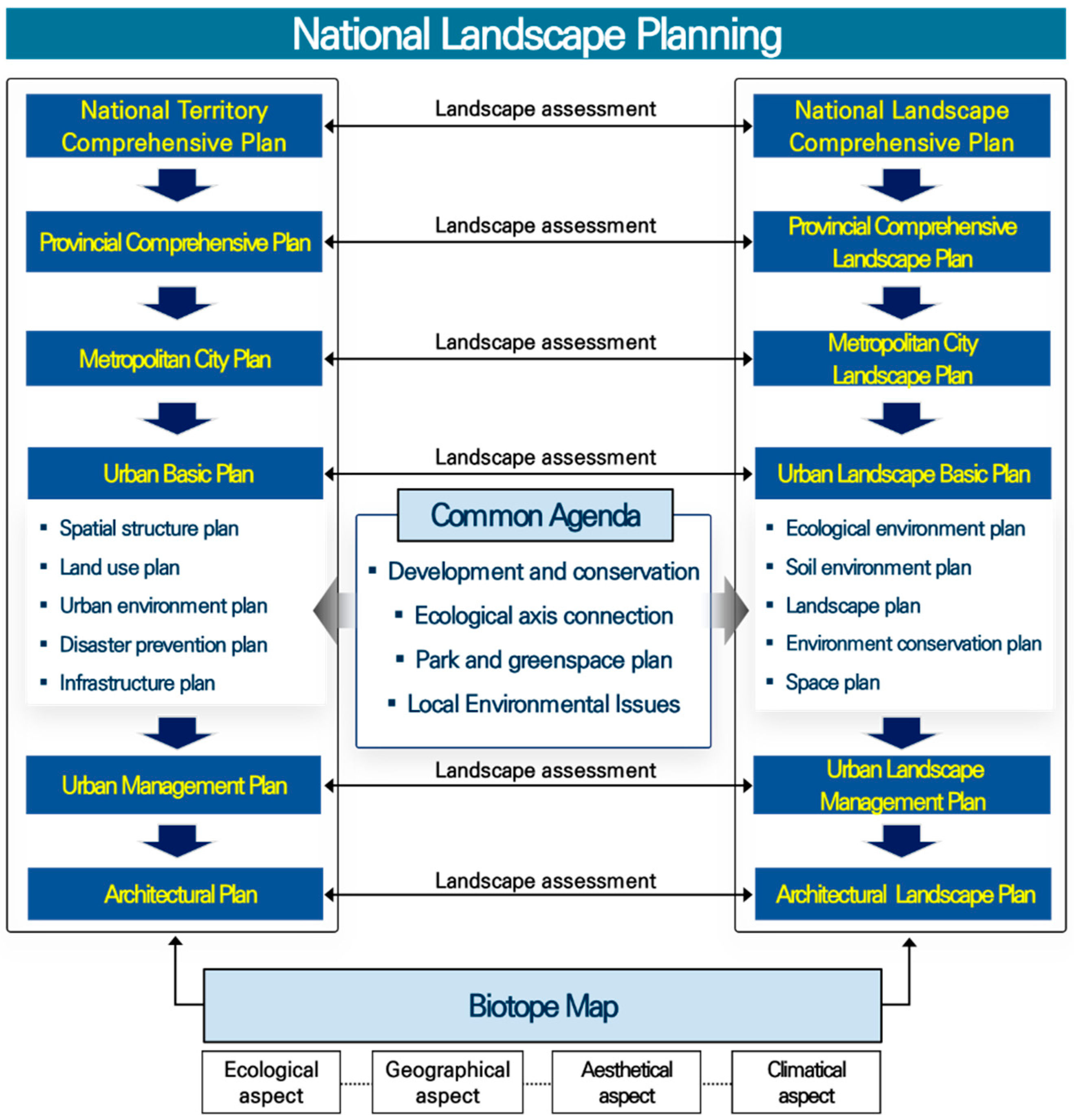
3.3. Content of Landscape Planning within the Legal System Related to National Landscape Planning
3.4. Basic Spatial Maps Related to National Landscape Planning
4. Discussion
5. Conclusions
Author Contributions
Funding
Institutional Review Board Statement
Informed Consent Statement
Data Availability Statement
Conflicts of Interest
References
- Song, M.K.; Chang, H. Characterization of Cities in Seoul Metropolitan Area by Cluster Analysis. J. Geospat. Inf. Sci. 2010, 18, 83–88. [Google Scholar]
- Kim, B.S.; Yuh, H.K. A Study on Functional Features in Types of the Cities in Korea. J. Geospat. Korea 2010, 44, 537–552. [Google Scholar]
- Kim, I.K. Socioeconomic concentration in the Seoul metropolitan area and its implications in the urbanization process of Korea. Korean J. Sociol. 2010, 44, 111–128. [Google Scholar]
- Froment, A. Landscape evaluation in the new land consolidation process in Belgium. In 1, IALE-World Congress (Abstract); International Association for Landscape Ecology: Veldhoven, The Netherlands, 1981; pp. 139–141. [Google Scholar]
- Gfeller, M.; Haug, U.; Schmid, W.A. Grundlagen der Landschaftsplanung-Die Landschaft und Ihre Nutzung; ORL: Zürich, Switzerland, 1987; pp. 60–75. [Google Scholar]
- Zonneveld, I.S. The Land Unit-A Fundamental Concept in Landscape Ecology and Its Applications. Landsc. Ecol. 1989, 3, 67–86. [Google Scholar] [CrossRef]
- Farina, A. Principles and Methods in Landscape Ecology; Chapman and Hall: London, UK, 1998; pp. 234–236. [Google Scholar]
- Bruns, D. Was kann Landschaftsplanung leisten? Alte und neue Funktionen der Landschaftsplanung. Nat. Landsch. 2003, 35, 114–118. [Google Scholar]
- Gobster, P.H. Landscape and urban planning at 100-Looking back moving forward. Landsc. Urban Plan. 2011, 100, 315–317. [Google Scholar] [CrossRef]
- Wiens, J.A. Landscape ecology as a foundation for sustainable conservation. Landsc. Ecol. 2009, 24, 1053–1065. [Google Scholar] [CrossRef]
- Kiemstedt, H. Natürliche Beeinträchtigungen als Entscheidungsfaktoren für die Planung. Landsch. Stadt 1971, 3, 80–85. [Google Scholar]
- Haber, W. Grundzüge einer ökologischen Theorie der Landnutzungsplanung. Inn. Kolonisation 1972, 21, 294–298. [Google Scholar]
- Leser, H. Landschaftsökologie; Eugen Ulmer: Stuttgart, Germany, 1991; pp. 128–145. [Google Scholar]
- Stojigren, T.J.; Coughenour, M.B.; Chong, G.W.; Binkley, D.; Kalkhan, M.A.; Schell, L.D.; Buckley, D.J.; Berry, J.K. Landscape analysis of plant diversity. Landsc. Ecol. 1997, 12, 155–170. [Google Scholar] [CrossRef]
- Krajewski, P. Monitoring of Landscape Transformations within Landscape Parks in Poland in the 21st Century. Sustainability 2019, 11, 2410. [Google Scholar] [CrossRef]
- Anna, Z. Lanscape Changes in Protected Areas in Poland. Sustainability 2022, 14, 753. [Google Scholar]
- Łowicki, D. Land use changes in Poland during transformation: Case study of Wielkopolska region. Landsc. Urban Plan. 2008, 87, 279–288. [Google Scholar] [CrossRef]
- Hassett, E.M.; Stehman, S.V.; Wickham, J.D. Estimating landscape pattern metrics from a sample of land cover. Landsc. Ecol. 2012, 27, 133–149. [Google Scholar] [CrossRef]
- Niemelä, J.; Saarela, S.R.; Söderman, T.; Kopperoinen, L.; Yli-Pelkonen, V.; Väre, S.; Kotze, D.J. Using the ecosystem services approach for better planning and conservation of urban green spaces: A Finland case study. Biodivers. Conserv. 2010, 19, 3225–3243. [Google Scholar] [CrossRef]
- Nowicki, P.; Bennett, G.; Middleton, D.; Rientjes, S.; Wolters, R. Perspectives on Ecological Networks; European Center of Nature Conservation: Arnhem, The Netherlands, 2006. [Google Scholar]
- Thornton, D.H.; Branch, L.C.; Sunquist, M.E. The influence of landscape, patch, and within-patch factors on species presence and species-area relationship for urban butterfly communities. Landsc. Ecol. 2011, 26, 7–18. [Google Scholar] [CrossRef]
- Downs, J.A.; Horner, M.W. Enhancing habitat connectivity in fragmented landscapes: Spatial modeling of wildlife crossing structures in transportation networks. Ann. Am. Assoc. Geogr. 2012, 102, 17–34. [Google Scholar] [CrossRef]
- Lizee, M.H.; Manel, S.; Mauffrey, J.F.; Tatoni, T.; Cottin, M.D. Matrix configuration and patch isolation influences override the species-area relationship for urban butterfly communities. Landsc. Ecol. 2012, 27, 159–169. [Google Scholar] [CrossRef]
- Forman, R.T.; Godron, M. Patches and structural components for a landscape ecology. BioScience 1981, 31, 733–740. [Google Scholar]
- Zetterberg, A.; Mörtberg, U.M.; Balfors, B. Making graph theory operational for landscape ecological assessments, planning, and design. Landsc. Urban Plan. 2010, 95, 181–191. [Google Scholar] [CrossRef]
- Palmer, J.F. The contribution of a GIS-based landscape assessment model to a scientifically rigorous approach to visual impact assessment. Landsc. Urban Plan. 2019, 189, 80–88. [Google Scholar] [CrossRef]
- Hobbs, R. Future landscapes and the future of landscape ecology. Landsc. Urban Plan. 1997, 37, 1–9. [Google Scholar] [CrossRef]
- Jansen, F.; Zerbe, S.; Succow, M. Changes in landscape naturalness derived from a historical land register-A case study from NE Germany. Landsc. Ecol. 2009, 24, 186–196. [Google Scholar] [CrossRef]
- Holland, E.P.; Aegerter, J.N.; Dytham, C. Comparing resource representations and choosing scale in heterogeneous landscapes. Landsc. Ecol. 2009, 24, 213–227. [Google Scholar] [CrossRef]
- McAlpine, C.A.; Seabrook, L.M.; Rhodes, J.R.; Maron, M.; Smith, C.; Bowen, M.E.; Butler, S.A.; Powell, O.; Ryan, J.G.; Fyfe, C.T.; et al. Can a problem-solving approach strengthen landscape ecology’s contribution to sustainable landscape planning? Landsc. Ecol. 2010, 25, 1155–1168. [Google Scholar] [CrossRef]
- Beunen, R.; Opdam, P. When landscape planning becomes landscape governance. what happens to the science? Landsc. Urban Plan. 2011, 100, 324–326. [Google Scholar] [CrossRef]
- Bishop, I.D. Landscape planning is not a game-Should it be? Landsc. Urban Plan. 2011, 100, 390–392. [Google Scholar] [CrossRef]
- Parece, T.; McGee, J.A.; Campbell, J.B. Remote Sensing with ArcGIS Pro. Virginia; Geospatial Consortium: Wayland, MA, USA, 2019. [Google Scholar]
- Gillanders, S.N.; Coops, N.C.; Wulder, M.A. Multitemporal remote sensing of landscape dynamics and pattern change: Describing natural and anthropogenic trends. Prog. Phys. Geogr. 2008, 32, 503–528. [Google Scholar] [CrossRef]
- Chen, Y.H. Application of GIS and remote sensing technology in the production of image map. Electron. Test. 2016, 11, 107–108. [Google Scholar]
- Yi, L.; Zhang, G. Object-oriented remote sensing imagery classification accuracy assessment based on confusion matrix. Proc. Int. Conf. Geoinf. 2012, 10, 1109. [Google Scholar]
- Bruzzone, L. Detection of changes in remotely-sensed images by the selective use of multi–spectral information. Int. J. Remote Sens. 1997, 18, 3883–3888. [Google Scholar] [CrossRef]
- Griffith, J.A. Geographic techniques and recent applications of remote sensing to landscape-water quality studies. Water Air Soil Pollut. 2002, 138, 181–197. [Google Scholar] [CrossRef]
- Hansen, A.J.; Piekielek, N.; Davis, C.; Haas, J.; Theobald, D.M.; Gross, J.E.; Monahan, W.B.; Olliff, T.; Running, S.W. Exposure of U.S. National Parks to land use and climate change 1900–2100. Ecol. Appl. 2014, 24, 484–502. [Google Scholar] [CrossRef] [PubMed]
- Wan, Z.; Snyder, W.C. Validation of land-surface temperature retriever from space. Proceedings of IGARSS 96, Noordwijk, The Netherlands: ESA Publications. Int. Geosci. Remote Sens. Semin. 1996, 4, 2095–2097. [Google Scholar]
- Xiao, H.; Kopecká, M.; Guo, S.; Guan, Y.; Cai, D.; Zhang, C.; Zhang, X.; Yao, W. Responses of Urban Land Surface Temperature on Land Cover: A Comparative Study of Vienna and Madrid. Sustainability 2018, 10, 260. [Google Scholar] [CrossRef]
- Geletič, J.; Lehnert, M.; Dobrovolný, P. Land Surface Temperature Differences within Local Climate Zones, Based on Two Central European Cities. Remote Sens. 2016, 8, 788. [Google Scholar] [CrossRef]
- Heo, H.K.; Seong, H.C.; Lee, D.K.; Heo, M.J.; Park, J.H. A Study on Assessment Indicators for Integrated Management on Korea National Planning and Environmental Planning. J. Korean Environ. Res. Technol. 2018, 21, 27–45. (In Korean) [Google Scholar]
- Ko, A.R.; Lim, J.W.; Kim, S.H. Classification and Characteristic Analysis of Mountain Village Landscape Using Cluster Analysis. J. Korean Soc. Rural. Plan. 2020, 26, 101–112. (In Korean) [Google Scholar] [CrossRef]
- Korea Research Institute for Human Settlements. A Study on the Urban Planning Measurement by Linking between National Land Plan and Environment Plan; Korea Research Institute for Human Settlements: Anyang-si, Korea, 2015; pp. 61–85. (In Korean) [Google Scholar]
- Kim, J.H.; RA, J.H.; Kwon, O.S. A Study on Improvement Measures Related to District Unit Planning to Induce Landscape-Friendly Planning in Non-Urban Areas. J. Korean Soc. Rural. Plan. 2021, 27, 1–11. (In Korean) [Google Scholar]
- Joo, S.H.; Im, S.B. A Study on the Landscape Adjectives for Urban Landscape Analysis. J. Korean Inst. Landsc. Archit. 2003, 31, 1–10. (In Korean) [Google Scholar]
- Ban, Y.U.; Baek, J.I.; Kim, M.A.; Yoon, J.O. Classifying Rural Landscape Types and Developing Rural Landscape Evaluation Indicators Using Expert Delphi Survey Method. J. Korean Soc. Rural. Plan. 2008, 14, 53–61. (In Korean) [Google Scholar]
- Kim, J.H.; Lee, H.T.; Ra, J.H.; Cho, H.J.; Sagong, J.H. Landscape Assessment and Improvement of the View Area by Selecting the Landscape Control Point. J. Korean Inst. Landsc. Archit. 2012, 40, 19–32. (In Korean) [Google Scholar] [CrossRef]
- Environmental Geographic Information Service. Available online: https://egis.me.go.kr (accessed on 10 March 2023).
- Humboldt, A. Ansichten der Natur-mit Wissenschaftlichen Erlaüterungen; J.G. Cotta’scher Verlag: Stuttgart, Germany, 1849. [Google Scholar]
- Neef, E. Die Theoretischen Grundlagen der Landschaftslehre; VEB Hermann Haack: Gotha/Leipzig Germany, 1967; p. 152. [Google Scholar]
- Berninger, O. Die Landschaft und ihre Gliederung. In Handbuch fuer Landschaftspflege und Naturschutz; Bd 1. Hrsg; Buchwald, K., Engelhardt, W., Eds.; BLV: Muenchen, Germany, 1968. [Google Scholar]
- Haeckel, E. Generelle Morphologie der Organismen; Reime: Berlin, Germany, 1866. [Google Scholar]
- Sukopp, H.; Weiler, S. Biotope mapping and nature conservation strategies in urban areas of Federal Republic of Germany. Landsc. Urban Plan. 1988, 15, 39–58. [Google Scholar] [CrossRef]
- Jedicke, E. Biotopverbund für Alt-und Totholz-Lebensräume-Leitlinien eines Schutzkonzepts inner- und außerhalb von Natura 2000. Nat. Landsch. 2008, 40, 379–385. [Google Scholar]
- Handke, K.; Tesch, A.; Nagler, A. Landesweite Biotopverbundplanung- Umsetzung und Ergebnisse in Bremen. Nat. Landsch. 2011, 43, 37–45. [Google Scholar]
- Heydemann, B. Vorschlag für ein Biotopschutzzonenkonzept am Beispiel Schleswig-Holsteins-Ausweisung von schutzwürdigen Ökosystemen und Fragen ihrer Vernetzung. Schr. Des Dt. Rates Für Landespfl. 1983, 41, 95–104. [Google Scholar]
- Brady, M.J.; McAlpine, C.A.; Miller, C.J.; Possingham, H.P.; Baxter, G.S. Habitat attributes of landscape mosaics along a gradient of matrix development intensity-matrix management matters. Landsc. Ecol. 2009, 24, 879–891. [Google Scholar] [CrossRef]
- Schippers, P.; Grashof-Bokdam, C.J.; Verboom, J.; Baveco, J.M.; Jochem, R.; Meeuwsen, H.A.M.; Adrichem, M.H.C. Sacrificing patches for linear habitat elements enhances metapopulation performance of woodland birds in fragmented landscapes. Landsc. Ecol. 2009, 24, 1123–1133. [Google Scholar] [CrossRef]
- Yoshio, N. Civil Engineering College 13 Landscape Theory; Shokokusha: Tokyo, Japan, 1977; pp. 2–8. Available online: https://www.shokokusha.co.jp/ (accessed on 10 March 2023).
- Eckbo, G. The Landscape We See; Mcgraw-Hill Book Company: New York, NY, USA; Toronto, ON, Canada; London, UK; Sydney, Australia, 1969. [Google Scholar]
- Tress, B. Eine Theorie der Landschaft. In Proceedings of the Zukunft Mitteleuropäischer Kulturlandschaften-Tagungsband IALE-D 2000, Nürtingen, Germany, 20–22 July 2000; Volume 2000, pp. 14–15. [Google Scholar]
- Mitsch, W.J.; Gosselink, J.G. The value of wetlands: Importance of scale and landscape setting. Ecol. Econom. 2000, 35, 25–33. [Google Scholar] [CrossRef]
- Clarkson, B.R.; Ausseil, A.-G.E.; Gerbeaux, P. Wetland Ecosystem Services. In Ecosystem Services in New Zealand: Conditions and Trends; Dymond, J.R., Ed.; Manaaki Whenua Press: Lincoln, New Zealand, 2013; ISBN 9780478347364. [Google Scholar]
- Mitsch, W.J.; Bernal, B.; Hernandez, M.E. Ecosystem services of wetlands. Int. J. Biodivers. Sci. Ecosyst. Serv. Manag. 2015, 11, 14. [Google Scholar] [CrossRef]
- Bassi, N.; Kumar, M.D.; Sharma, A.; Pardhasaradhi, P. Status of wetlands in India: A review of extent, ecosystem benefits, threats and management strategies. J. Hydrol. Reg. Stud. 2014, 2, 1–19. [Google Scholar] [CrossRef]
- Sagong, J.H.; Jung, O.S.; Yeo, H.B. Appraising the Worth of Ecosystem Services of Rice-fields in Chungcheongnam-do Region. J. Korean Soc. Rural. Plan. 2015, 21, 1–17. (In Korean) [Google Scholar] [CrossRef]
- Norris, P.E.; Rourke, M.O.; Mayer, A.S.; Halvorsen, K.E. Managing the wicked problem of transdisciplinary team formation in socio-ecological systems. Landsc. Urban Plan. 2016, 154, 115–122. [Google Scholar] [CrossRef]
- Taylor, L.; Hochuli, D. Defining greenspace: Multiple uses across multiple disciplines. Landsc. Urban Plan. 2017, 158, 25–38. [Google Scholar] [CrossRef]
- Cho, H.J.; Ra, J.H.; Kwon, O.S. The Development and Application of Biotop Value Assessment Tool(B-VAT) Based on GIS to Measure Landscape Value of Biotop. J. Korean Soc. Rural. Plan. 2012, 18, 13–26. (In Korean) [Google Scholar]


| Division | Area (km2) | Population | Ratio of Population to Total Population (%) |
|---|---|---|---|
| Seoul (Capital of S. Korea) | 605.20 | 9,770,638 | 18.85 |
| Pusan metropolitan city | 769.89 | 3,436,230 | 6.63 |
| Daegu metropolitan city | 883.57 | 2,458,138 | 4.74 |
| Incheon metropolitan city | 1062.60 | 2,956,063 | 5.70 |
| Kwangju metropolitan city | 501.24 | 1,459,208 | 2.82 |
| Daejeon metropolitan city | 539.35 | 1,487,605 | 2.87 |
| Ulsan metropolitan city | 1060.79 | 1,153,735 | 2.23 |
| Sejong special self-governing city | 467.87 | 320,326 | 0.62 |
| Gyeonggi province | 10,183.46 | 13,104,696 | 25.28 |
| Kwangwon province | 16,875.03 | 1,540,445 | 2.97 |
| Chungpook province | 7407.29 | 1,598,868 | 3.08 |
| Chungnam province | 8226.14 | 2,125,372 | 4.10 |
| Jeonbook province | 8069.05 | 1,832,227 | 3.54 |
| Jeonnam province | 12,318.79 | 1,875,862 | 3.62 |
| Kyungpook province | 19,031.42 | 2,671,587 | 5.15 |
| Kyungnam province | 10,539.56 | 3,371,016 | 6.50 |
| Jeju special self-governing province | 1849.15 | 667,522 | 1.29 |
| Total | 100,387.4 | 51,829,538 | 100 |
| Division | Urban Area | Agricultural Land | Forest | Grass | Wet Land | Barren | Water |
|---|---|---|---|---|---|---|---|
| Seoul | 3.54 (0.17%) | −30.63 (1.23%) | 9.37 (0.62%) | 7.42 (−0.82%) | −0.59 (0.11%) | 11.99 (3.31%) | −1.02 (−1.98%) |
| Pusan | 64.65 (3.19%) | −37.47 (1.50%) | −15.80 (−1.05%) | −12.41 (1.37%) | 2.46 (−0.46%) | 12.24 (3.38%) | −13.92 (−26.97%) |
| Daegu | 32.56 (1.61%) | −85.37 (3.42%) | 52.20 (3.46%) | −22.79 (2.51%) | 0.13 (−0.02%) | 9.60 (2.65%) | 13.67 (26.48%) |
| Incheon | 66.99 (3.31%) | −49.10 (1.97%) | −14.17 (−0.94%) | 58.71 (−6.47%) | −38.69 (7.22%) | 55.79 (15.39%) | −78.85 (−152.81%) |
| Kwangju | 70.64 (3.49%) | −91.68 (3.67%) | 23.00 (1.52%) | 1.05 (−0.12%) | −0.26 (0.05%) | −5.75 (−1.59%) | 3.01 (5.83%) |
| Daejeon | 42.22 (2.09%) | −45.40 (1.82%) | 18.21 (1.21%) | −3.39 (0.37%) | −0.02 (0%) | −11.29 (−3.12%) | −0.32 (−0.62%) |
| Ulsan | 64.02 (3.16%) | −85.01 (3.41%) | 13.49 (0.89%) | −12.34 (1.36%) | 0.52 (−0.10%) | 20.69 (5.71%) | −1.31 (−2.54%) |
| Sejong | 7.59 (0.38%) | −12.14 (0.49%) | 9.24 (0.61%) | −12.06(1.33%) | 0.13 (−0.02%) | 4.09 (1.13%) | 3.16 (6.13%) |
| Gyeonggi | 478.34 (23.63%) | −291.31 (11.67%) | −255.37 (−16.93%) | −23.30 (2.57%) | −14.30 (2.67%) | 151.63 (41.82%) | −43.65 (−84.60%) |
| Kwangwon | 122.90 (6.07%) | −289.90 (11.62%) | 209.70 (13.90%) | −33.57 (3.70%) | −5.32 (0.99%) | 3.24 (0.89%) | −6.67 (−12.92%) |
| Chungpook | 100.50 (4.97%) | −128.50 (5.15%) | 29.06 (1.93%) | 11.04 (−1.22%) | −0.11 (0.02%) | −5.63 (−1.55%) | −5.94 (−11.52%) |
| Chungnam | 163.50 (8.08%) | −50.45 (2.02%) | 162.08 (10.75%) | −201.06 (22.15%) | −104.78 (19.57%) | 51.60 (14.23%) | −20.26 (−39.26%) |
| Jeonbook | 231.23 (11.42%) | −92.58 (3.71%) | −54.23 (−3.60%) | −104.43 (11.50%) | −28.46 (5.32%) | 21.18 (5.84%) | 27.83 (53.93%) |
| Jeonnam | 217.73 (10.76%) | −389.47 (15.61%) | 572.21 (37.94%) | −118.43 (13.04%) | −345.98 (64.61%) | −28.27 (−7.80%) | 92.69 (179.63%) |
| Kyungpook | 149.00 (7.36%) | −845.71 (33.89%) | 756.47 (50.16%) | −152.63 (16.81%) | 4.04 (−0.75%) | 34.56 (9.53%) | 54.72 (106.05%) |
| Kyungnam | 179.06 (8.85%) | −411.17 (16.48%) | 268.79 (17.82%) | −94.57 (10.42%) | −3.84 (0.72%) | 29.29 (8.08%) | 33.89 (65.68%) |
| Jeju | 29.53 (1.46%) | 440.47 (−17.65%) | −276.04 (−18.30%) | −195.15 (21.49%) | −0.44 (0.08%) | 7.59 (2.09%) | −5.43 (−10.52%) |
| Total | 2024.00 (100%) | −2495.42 (100%) | 1508.20 (100%) | −907.90 (100%) | −535.51 (100%) | 362.55 (100%) | 51.60 (100%) |
| Legal System | Contents Related to Landscape Planning |
|---|---|
| The Framework Act on National Territory and its enforcement ordinance | Sustainable development of the country shall be promoted based on the harmony of development and environment The negative impact should be minimized by reviewing the impact on the natural environment in advance, and the damaged natural ecosystem should be restored Matters concerning the efficient use and management of national land resources such as land, water resources, forests, etc., and long-term policy directions for the preservation of the national environment shall be included Linkage with environmental plans shall be strengthened when formulating comprehensive plans for Do, comprehensive plans for Si, etc. |
| National Territory Planning Act and its enforcement ordinance | The basic urban plan shall include policy directions for conservation of the environment, park green, landscape, response to climate change, and energy conservation High-value natural landscape factors such as green areas, ecosystems, forests, and landscapes should be fully considered The contents of the urban management plan shall include a review of the environmental impact in advance and the link between the development plan and the environmental plan to promote sustainable urban development |
| Building Act and its enforcement ordinance | When constructing on a land with an area of 200 square meters or more, green spaces, such as landscaping or rooftop greening, shall be secured |
| Landscape Act and its enforcement ordinance | Excellent landscapes shall be preserved, damaged landscapes improved and restored, and newly formed landscapes shall be encouraged to have unique elements Long-term directions for natural scenery, historical and cultural landscapes, rural, mountain, fishing village landscapes, and urban landscapes should be presented Originality and diversity should be secured by fully reflecting regional characteristics and needs |
| Parks and Greenery Act and its enforcement ordinance | Comprehensive arrangement of park green areas, park green axes and networks, preservation, management and use of park green areas, and urban greening shall be included Long-term development directions for the preservation, expansion, management, and use of park green areas shall be presented Based on the basic survey of natural resources, the future of park green areas should be predicted and managed systematically and continuously It shall be in accordance with the contents of the higher plan and shall be considered in harmony with the sectoral plan of the basic urban plan |
| Natural Environment Conservation Act and its enforcement ordinance | The contents of the basic policy shall include matters concerning systematic conservation and management of the natural environment, protection of endangered species, restoration and restoration of damaged natural environment, and preservation of biodiversity The contents of the master plan shall include matters concerning the establishment and promotion of ecological axes, the establishment of ecological passages, restoration of damaged land, etc. In order to enhance the ecological soundness of the city, ecological natural road first-class areas, wetland protection areas, wildlife protection areas, etc., shall not be damaged Matters related to the creation of green areas and small ecosystems to promote biodiversity, and ecological technology for energy management shall be included |
| Rural Development Act and its enforcement ordinance | Plans for the management of rural landscapes shall include the goals and directions of landscape plans, matters concerning the investigation and evaluation of landscape resources, and matters for the management of each type, such as natural scenery, agricultural and fishery landscape, living landscape, etc. |
| Framework Act on Forestry and its enforcement ordinance | The state and local governments must create, protect, and manage forests so that various functions such as preservation of the national land environment and promotion of forest welfare can be fully exercised The head of the Korea Forest Service shall formulate a basic forest plan including the creation and promotion of forest resources, preservation and protection of forests, use and planning of forests, and promotion of forest welfare Local governments shall formulate and implement local forest plans every 20 years in consideration of the specificity of forests |
| Forest Resources Act and its enforcement ordinance | Efforts should be made to create ecological forests and arboretums for the conservation and management of forest biodiversity Conservation and management plans are established and managed for trees and forests that are deemed necessary to be specially protected in order to protect the ecology and landscape from damage caused by climate, air pollution, acid rain, or pests |
| Environmental Policy Framework Act and its enforcement ordinance | The state and local governments should devise ways to connect with national land planning in accordance with the Framework Act on National Territory when establishing environmental plans to maintain a sustainable national land environment When establishing or changing city/province environmental plans, mayors/provincial governors must manage spatial environment information on environmental changes by sector, such as water, air, and natural ecology |
| Division | Spatial Range | Scale | Presence of Value Rating |
|---|---|---|---|
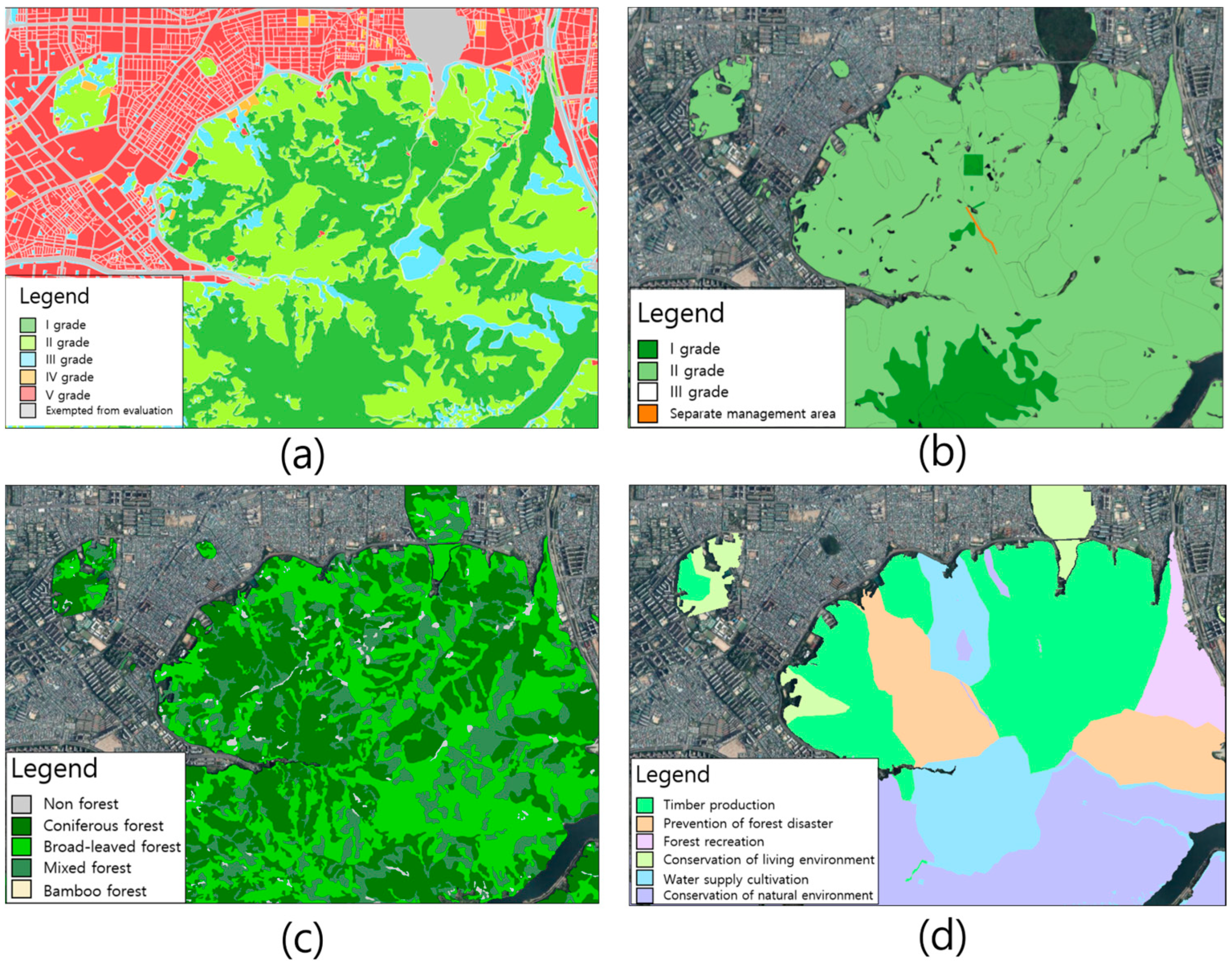
| Biotope map | All space | 1:5000/1:1000 | O(I~V grade) |
| Ecological zoning map | Forest | 1:25,000/1:5000 | O(I~III grade) |
| Forest type map | Forest | 1:25,000/1:5000 | X |
| Forest function classification map | Forest | 1:25,000/1:5000 | X |
| Categories | Contents Related to Landscape Planning |
|---|---|
| Biotope map | The mayors draw up biotope maps containing detailed ecological information on urban areas and rewrite them every five years to reflect changes in the urban environment A biotope map shall be prepared on a scale of at least 1/5000 When land use and development plans are formulated, the mayors shall actively utilize biotope maps containing detailed ecological information of the relevant space Mayors should give access to the biotope map to anyone |
| Ecological zoning map | The Ecological zoning map shall be marked with a solid line on a map of at least 1/25,000 Level 1 area: Conservation and restoration of the natural environment; Level 2 area: Conservation of the natural environment and minimization of damage caused by development and use; Level 3 area: Systematic development and use |
| Forest type map | The head of the Korea Forest Service shall draw up a plan (hereinafter referred to as “Forest type map”) that comprehensively displays the current state of forests, such as types, diameters, and ages of trees, for forests nationwide in order to utilize them for the efficient management of forests. Forest type maps should be drawn up based on aerial photographs, satellite images, and on-site surveys, but with a scale of 1/25,000 or higher |
| Forest function classification map | In order to efficiently create and foster forest resources, the head of the Korea Forest Service shall prepare a forest-function classification map in consideration of the location, location conditions, direction of use, etc., of forests The functions of forests are classified watershed conservation forest, mountain disaster prevention forest, natural environment-preservation forest, timber production forest, forest recreation forest, living-environment preservation forest Functional classification maps shall be prepared with a scale of at least 1/25,000 |
Disclaimer/Publisher’s Note: The statements, opinions and data contained in all publications are solely those of the individual author(s) and contributor(s) and not of MDPI and/or the editor(s). MDPI and/or the editor(s) disclaim responsibility for any injury to people or property resulting from any ideas, methods, instructions or products referred to in the content. |
© 2023 by the authors. Licensee MDPI, Basel, Switzerland. This article is an open access article distributed under the terms and conditions of the Creative Commons Attribution (CC BY) license (https://creativecommons.org/licenses/by/4.0/).
Share and Cite
Cho, H.-J.; Kim, J.-H.; Lee, E.-J. A Study on the Advancement of Spatial Maps and the Improvement of the Legal System as a Key Tool for Sustainable National Landscape Planning: Case Study of South Korea. Land 2023, 12, 1044. https://doi.org/10.3390/land12051044
Cho H-J, Kim J-H, Lee E-J. A Study on the Advancement of Spatial Maps and the Improvement of the Legal System as a Key Tool for Sustainable National Landscape Planning: Case Study of South Korea. Land. 2023; 12(5):1044. https://doi.org/10.3390/land12051044
Chicago/Turabian StyleCho, Hyun-Ju, Jin-Hyo Kim, and Eun-Jae Lee. 2023. "A Study on the Advancement of Spatial Maps and the Improvement of the Legal System as a Key Tool for Sustainable National Landscape Planning: Case Study of South Korea" Land 12, no. 5: 1044. https://doi.org/10.3390/land12051044