

The Multidisciplinary Approach in the Study of Landscape Evolution: The Fluvial Capture of the San Donato Creek (Gubbio, Central Italy), an Example of Hydrological Regime and Hydrogeological Risk Changes

Abstract
:1. Introduction
2. Materials and Methods
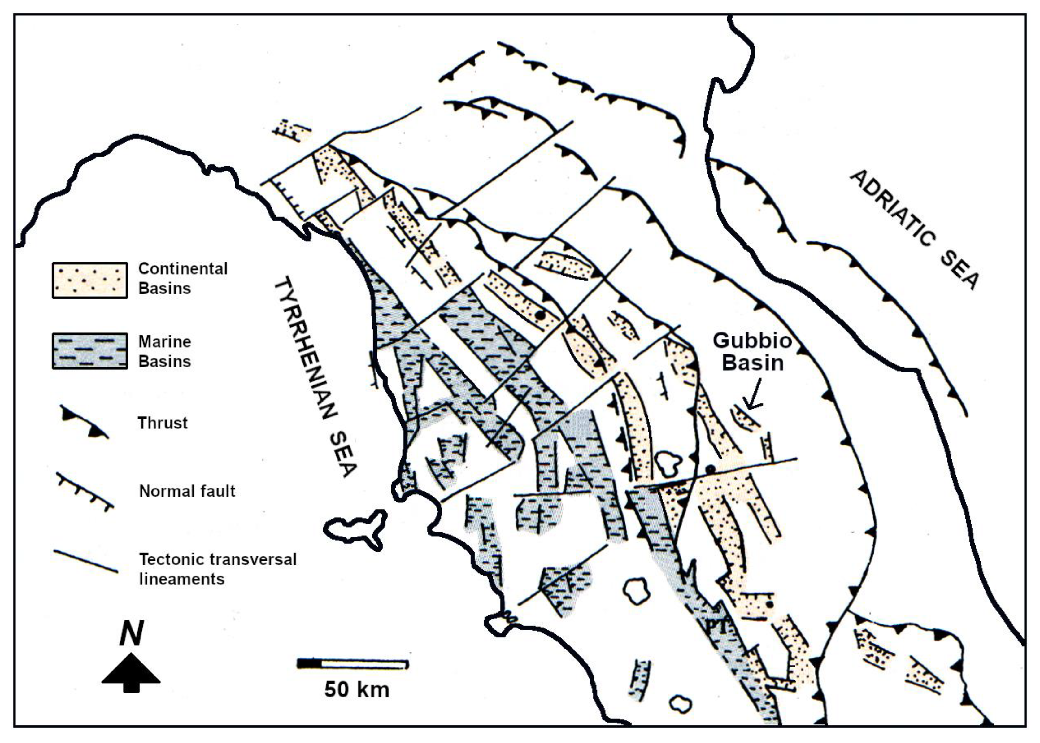
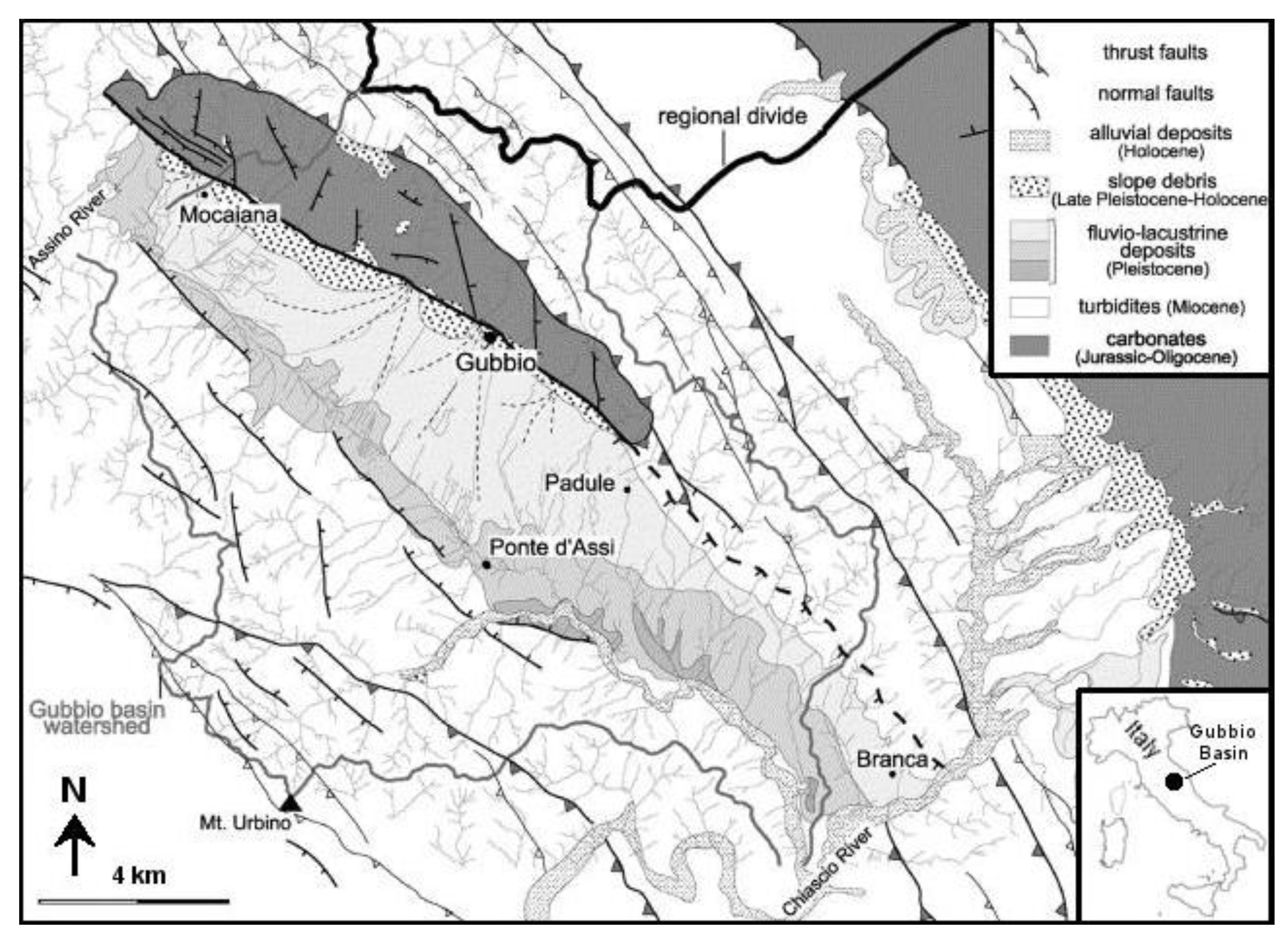
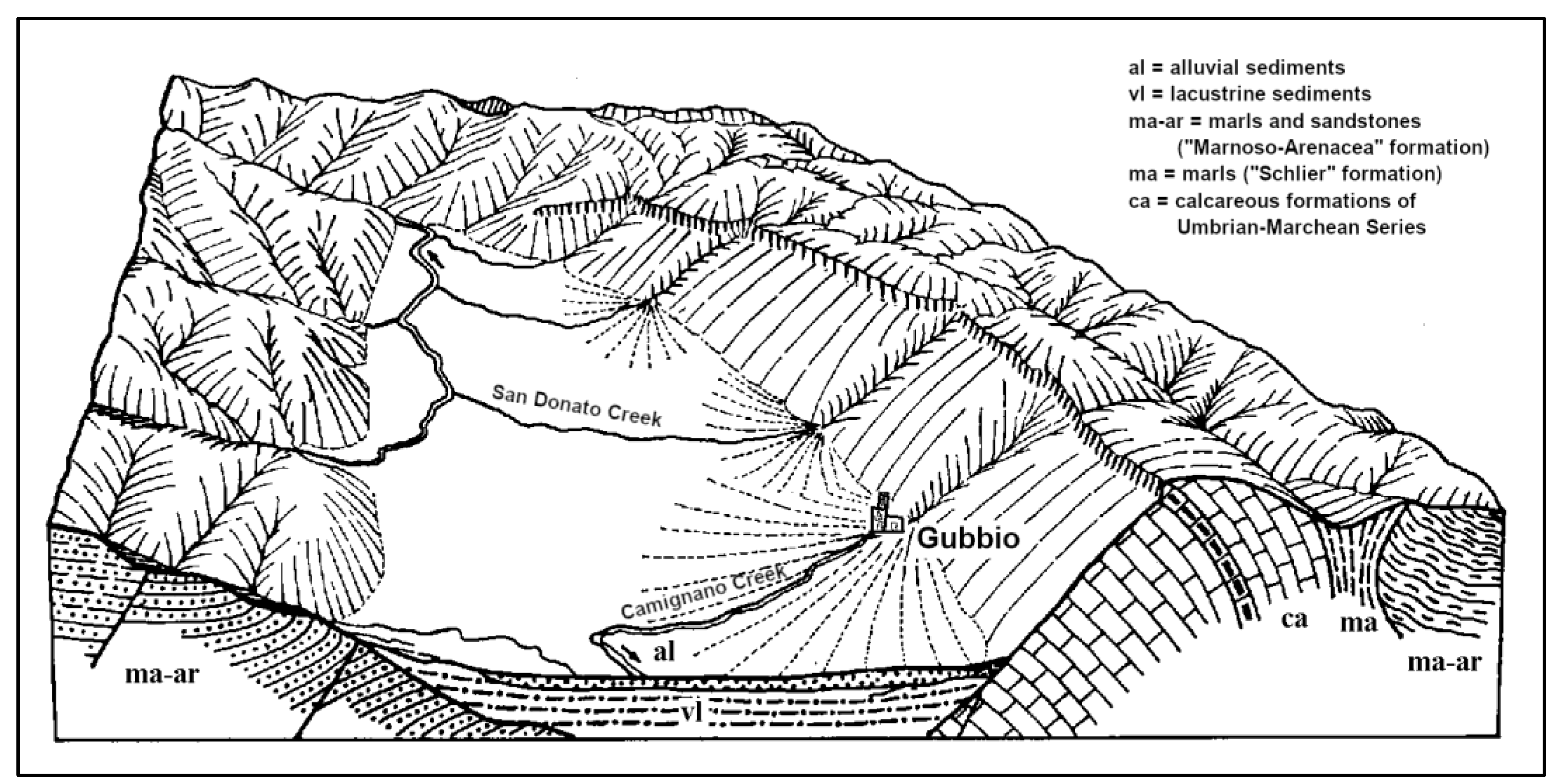
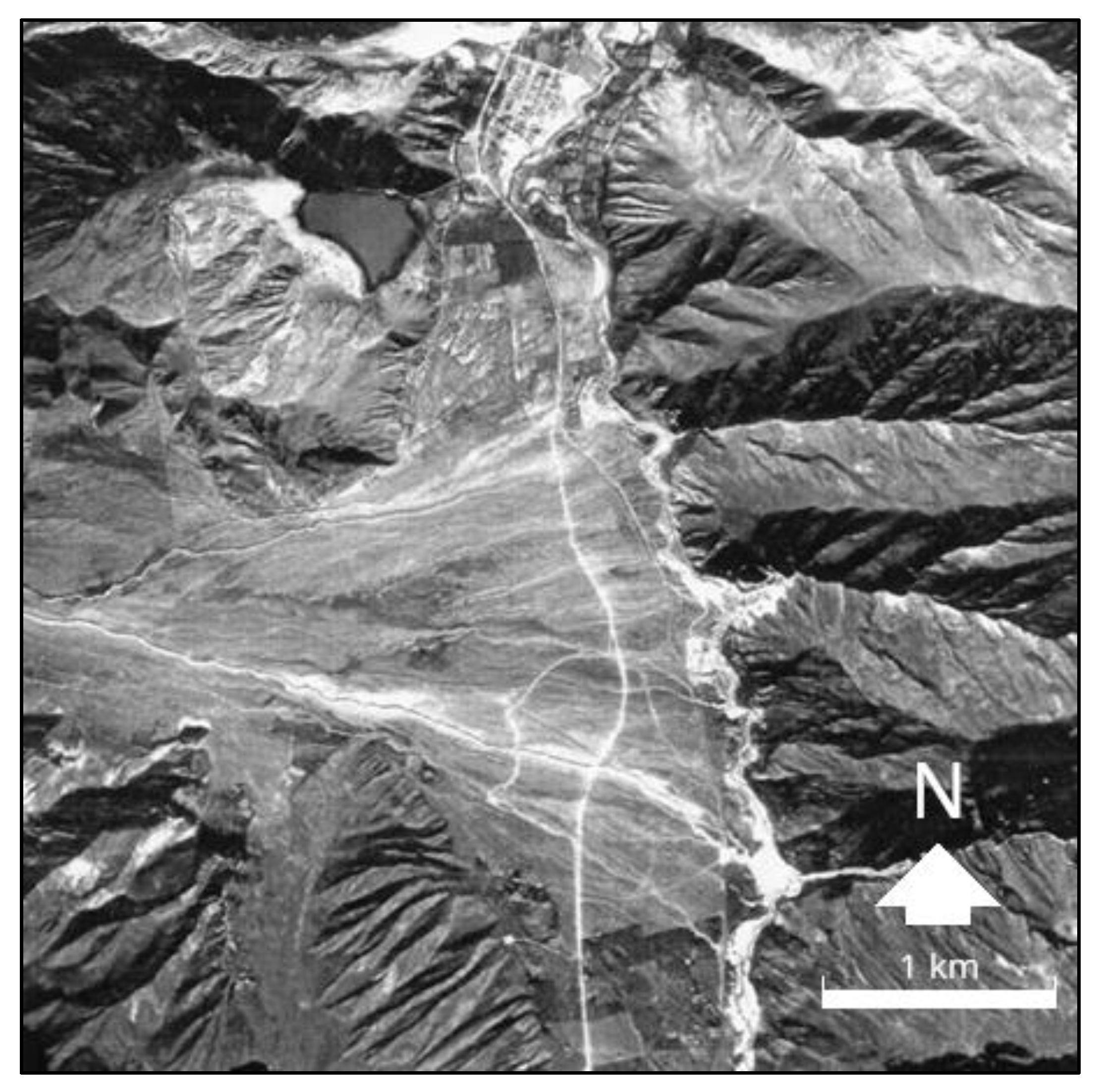
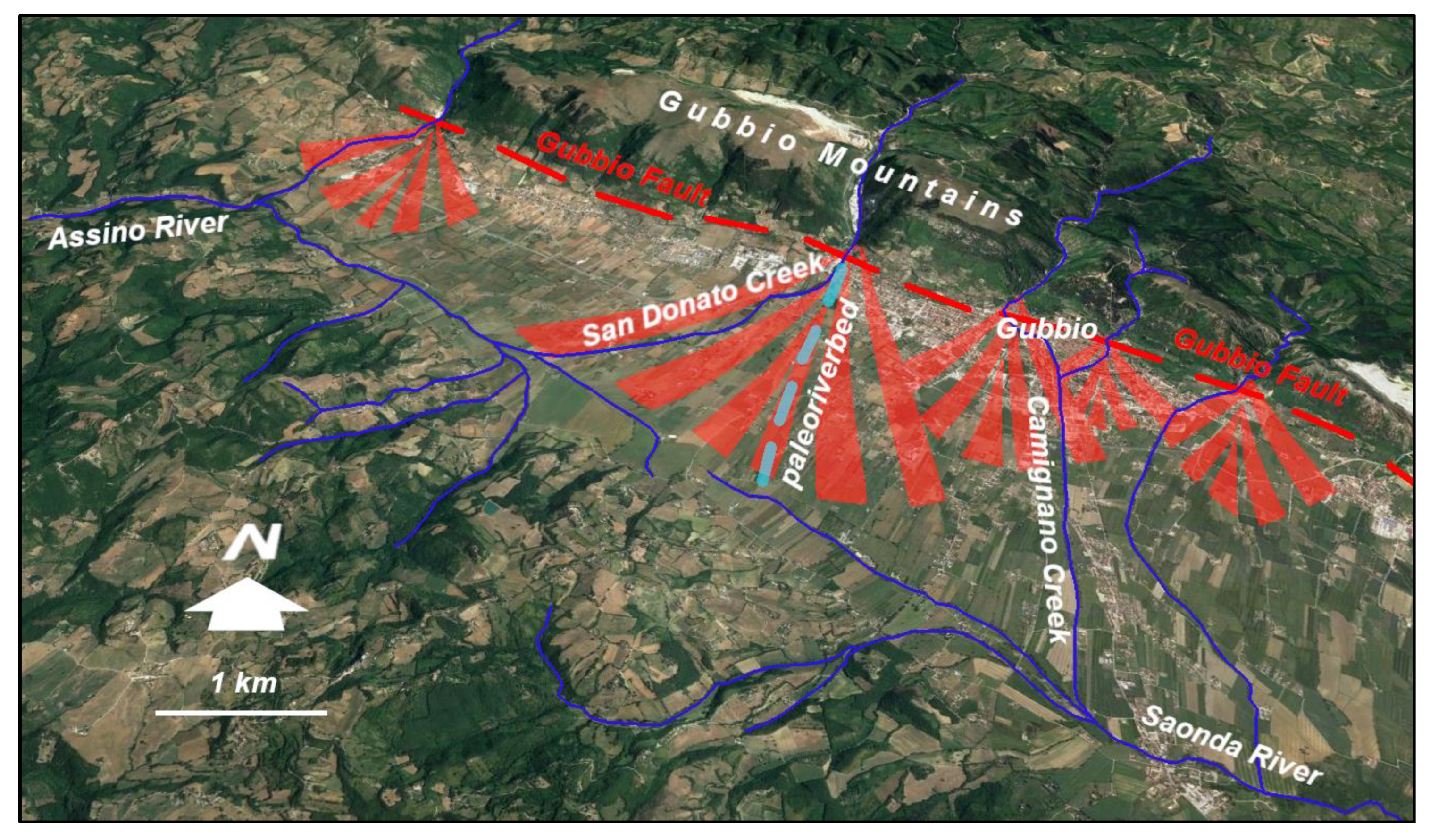
2.1. Geological-Geomorphological Framework of the Study Area
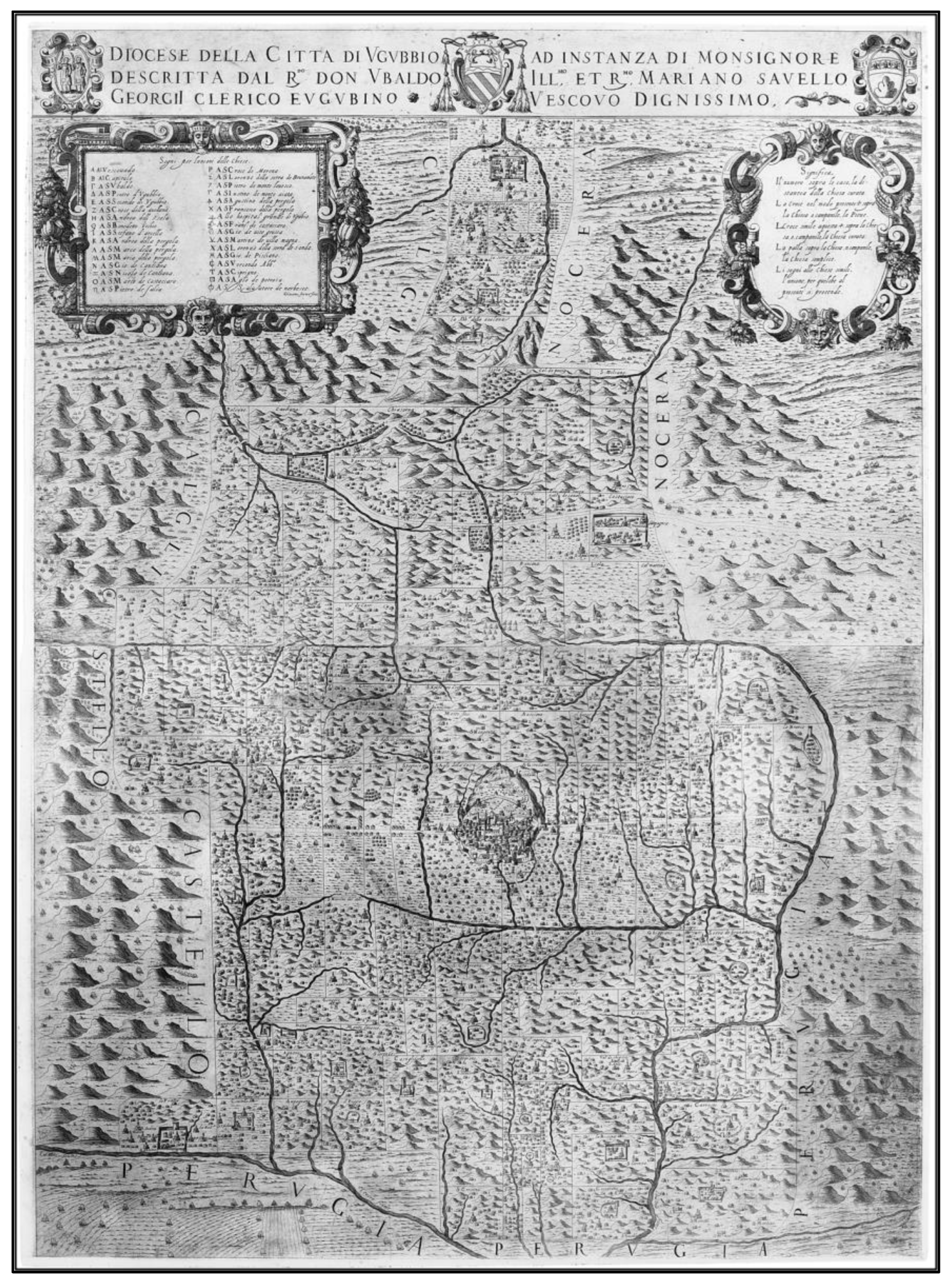
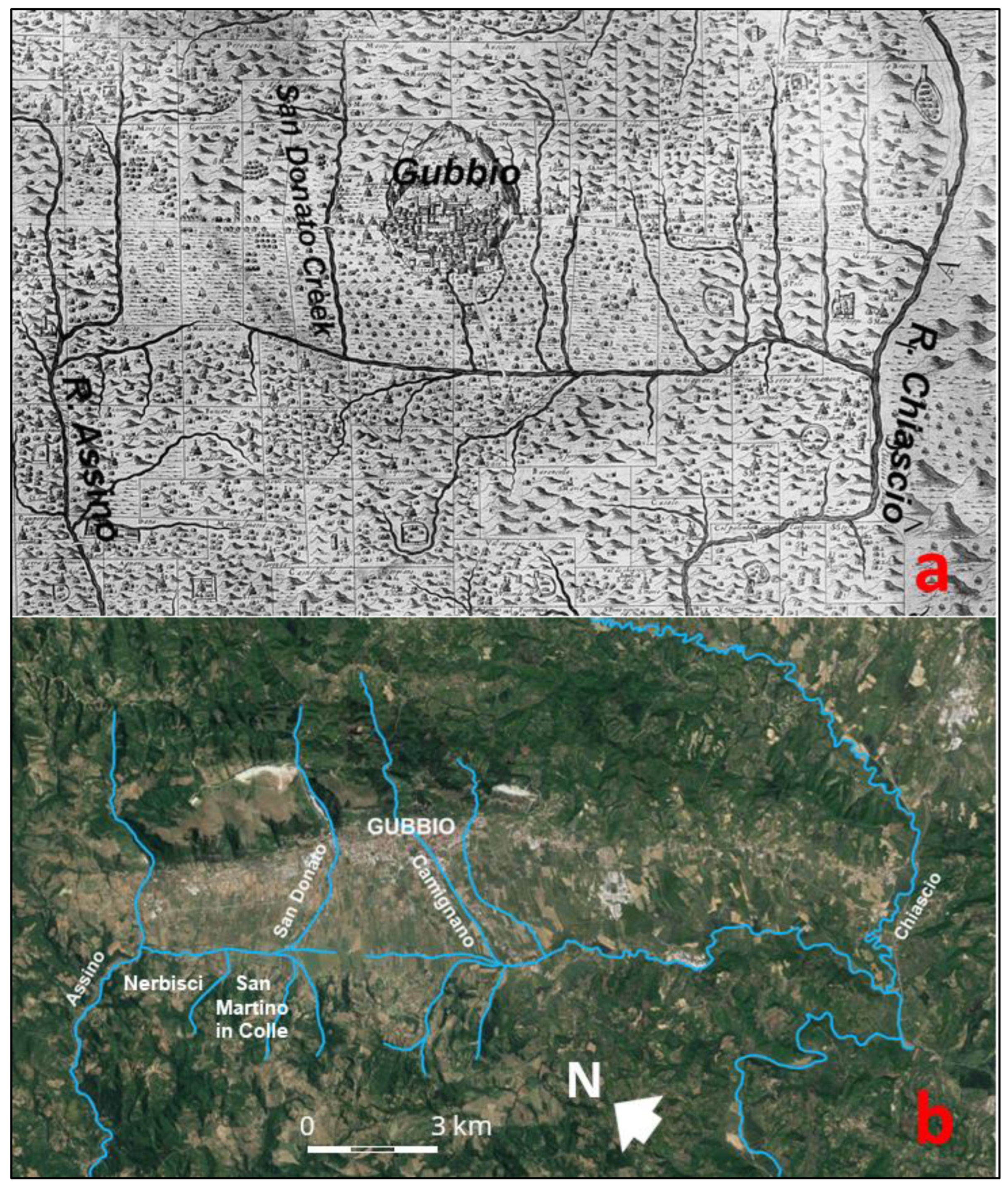
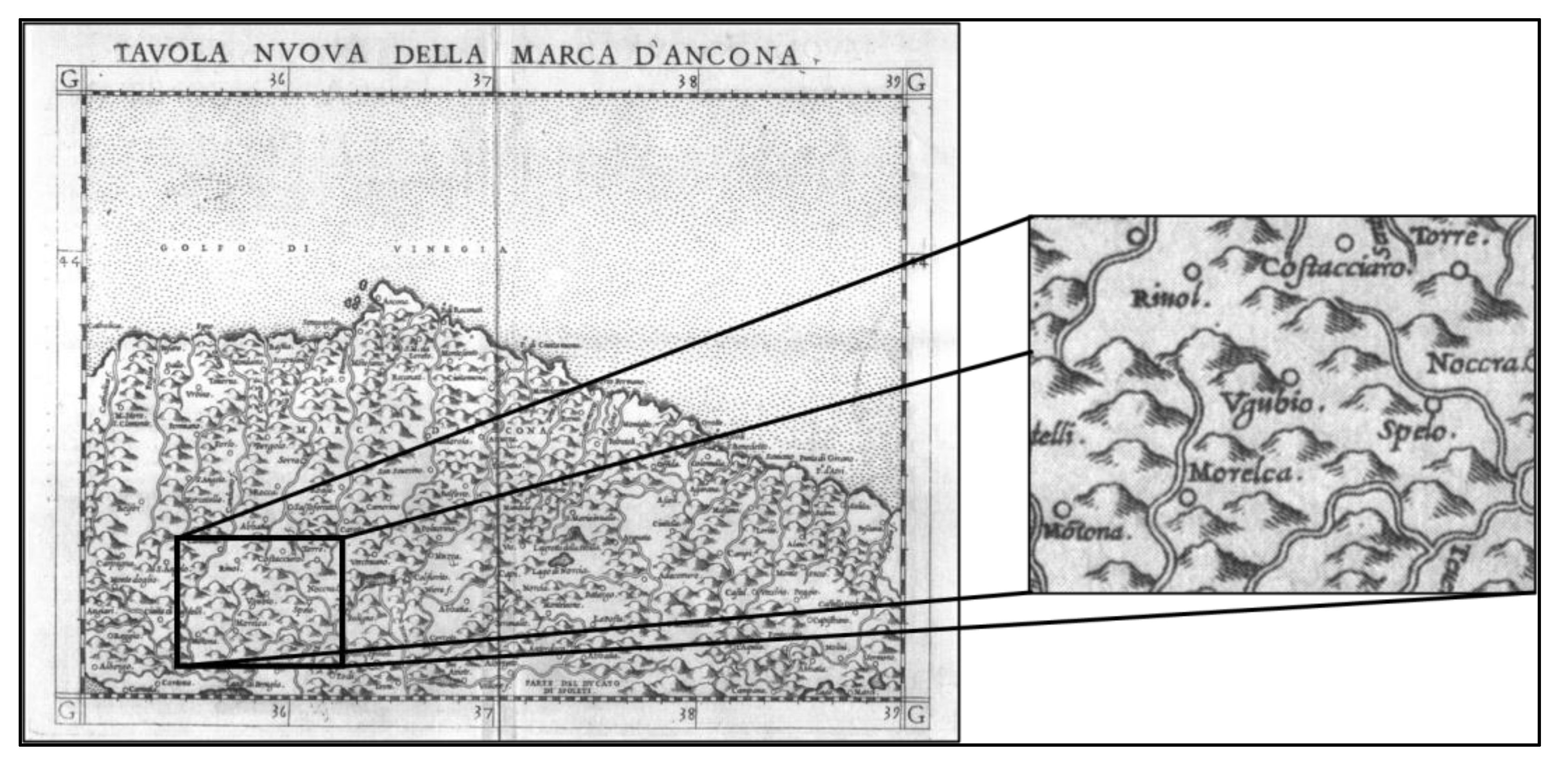
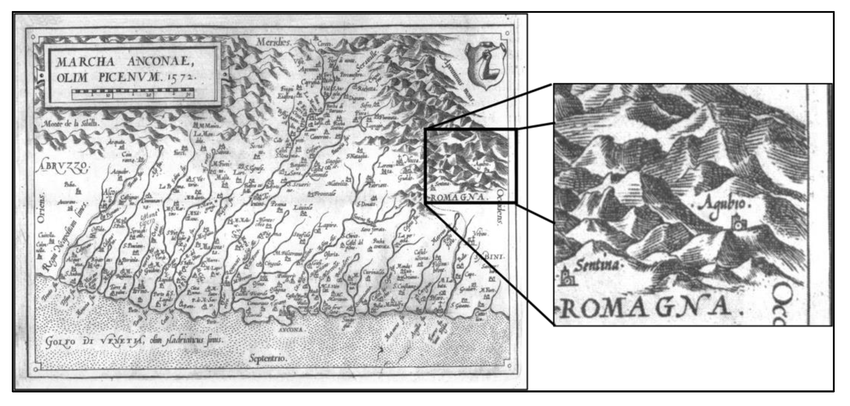
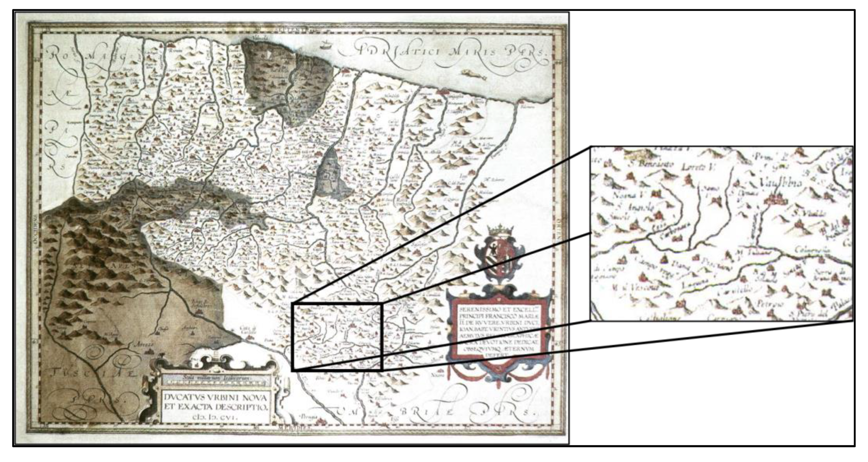
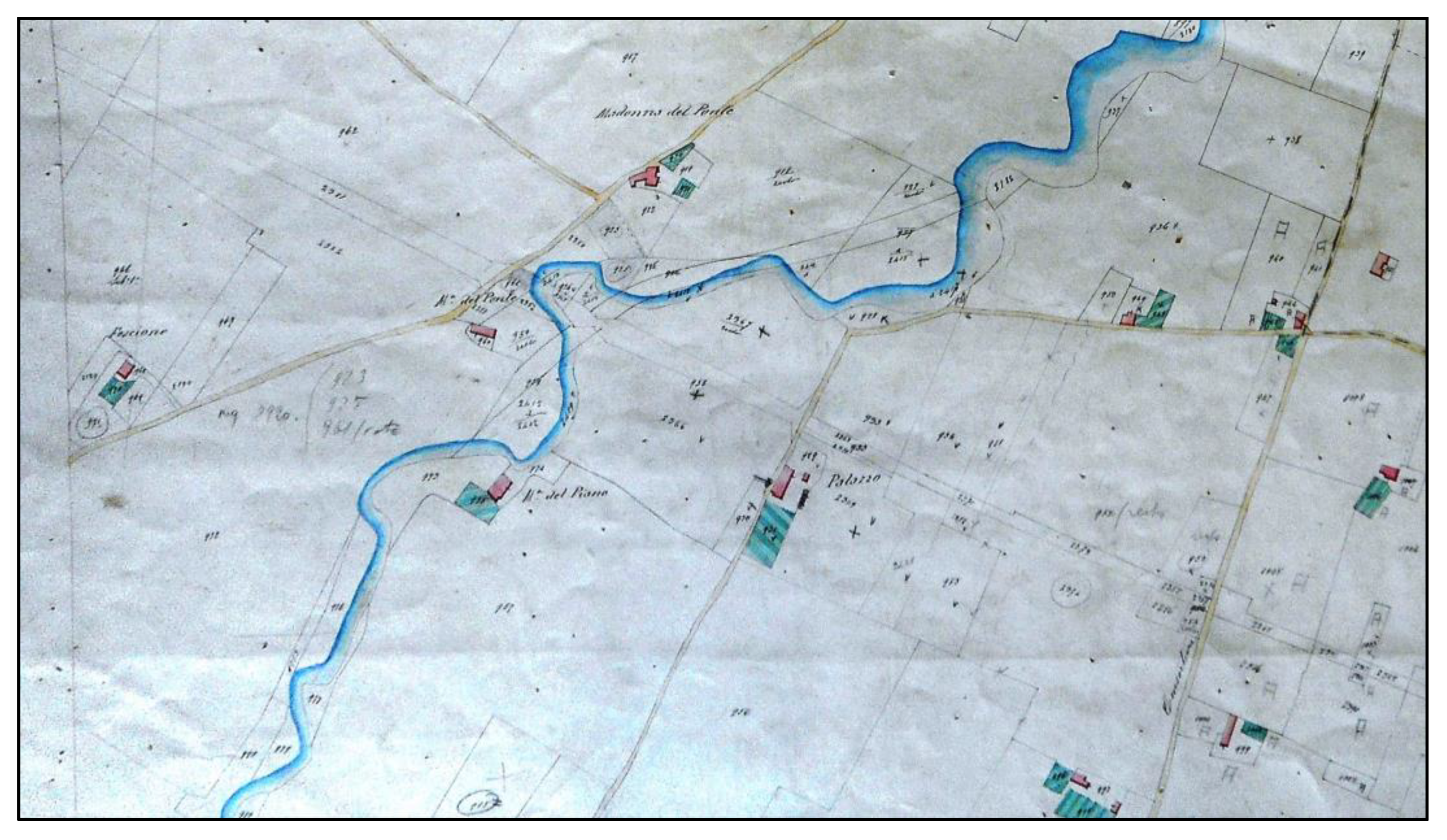
2.2. The Georgi’s Map
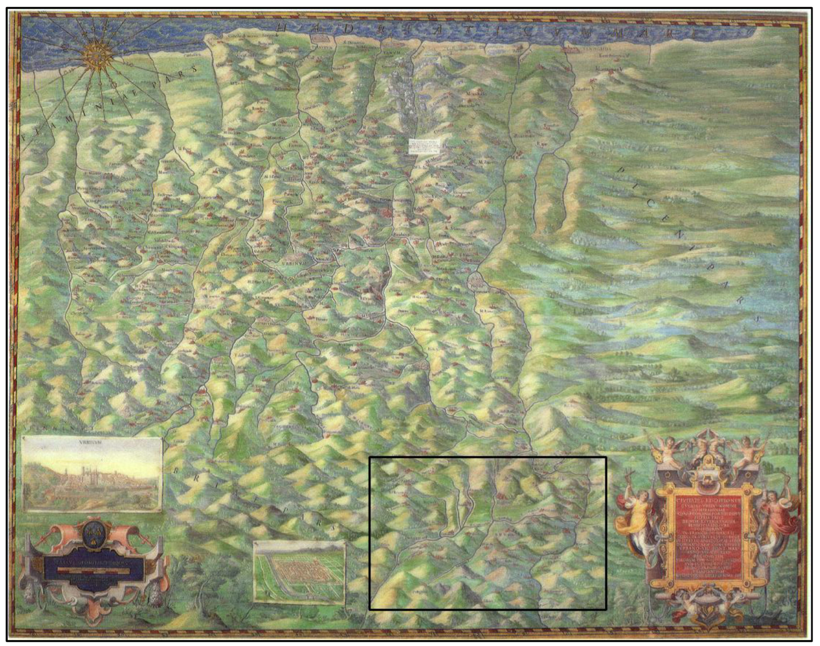
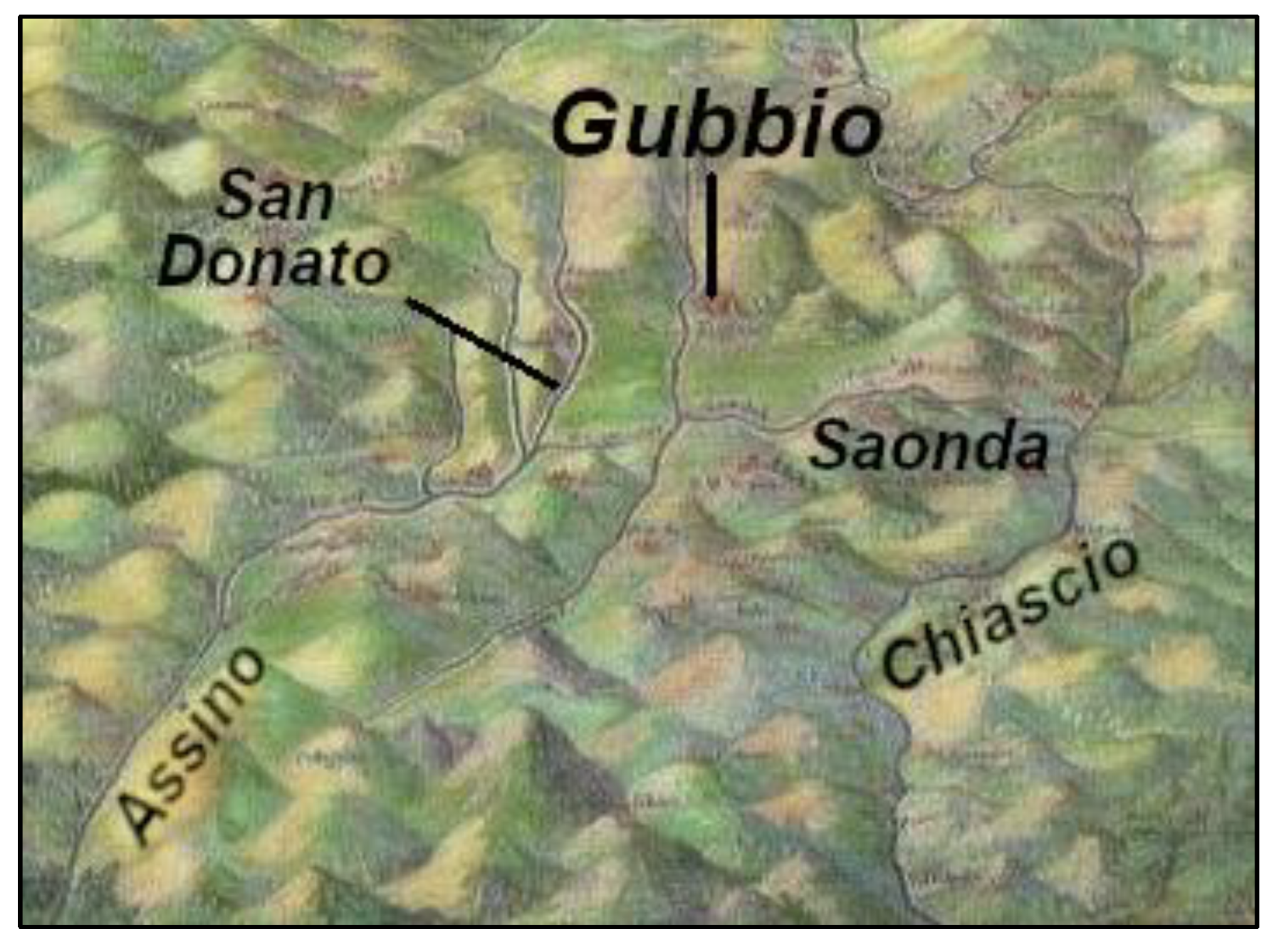
2.3. The Anomaly of the Hydrographic Network Represented in the Georgi’s Map
2.4. The Data Available
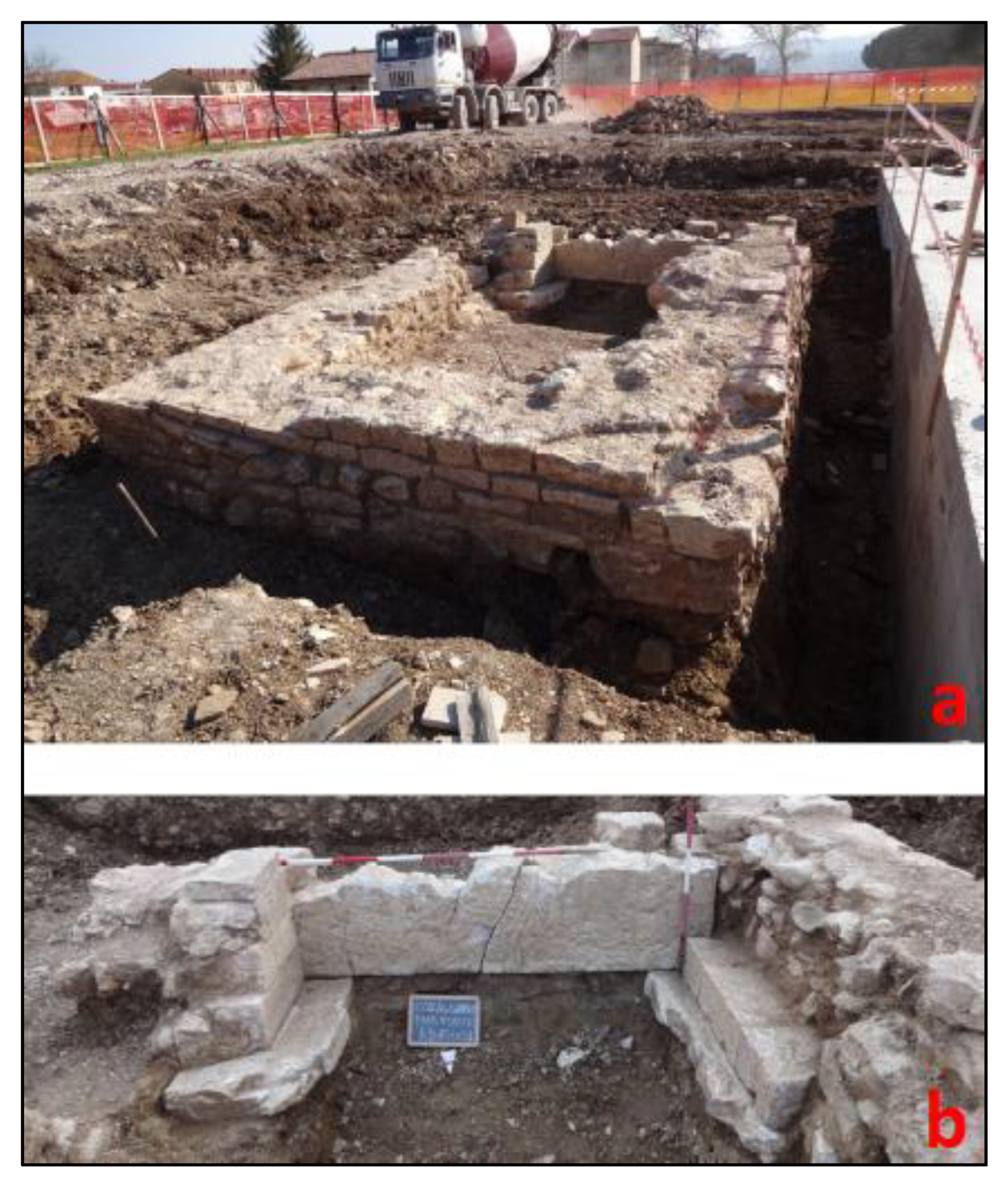
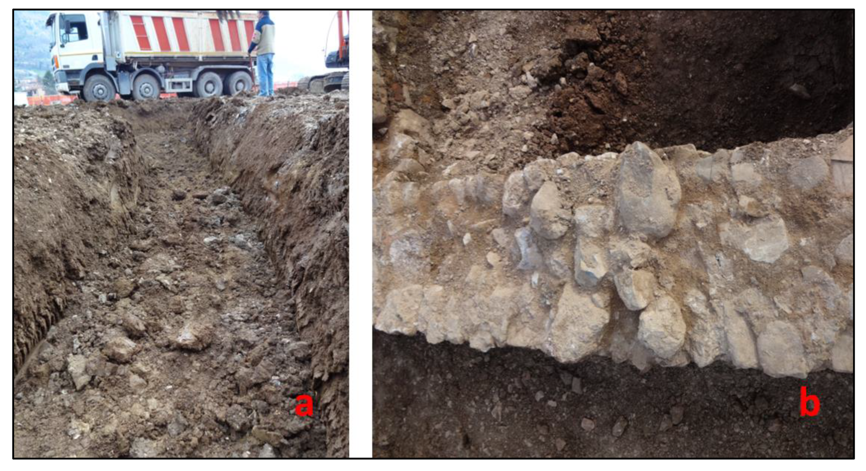
2.4.1. The Field Investigation
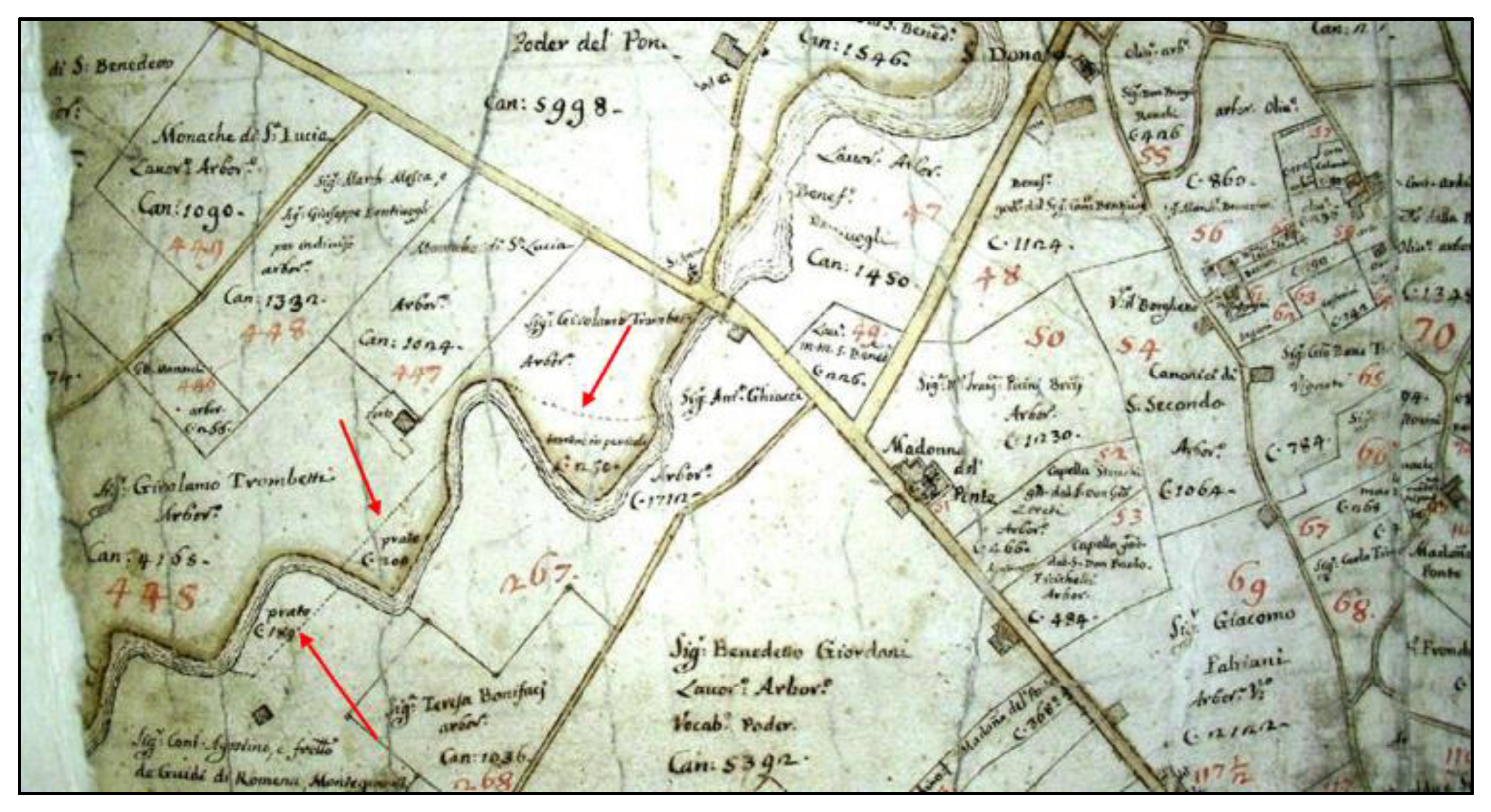
2.4.2. The Historical-Cartographic Investigation
3. Results
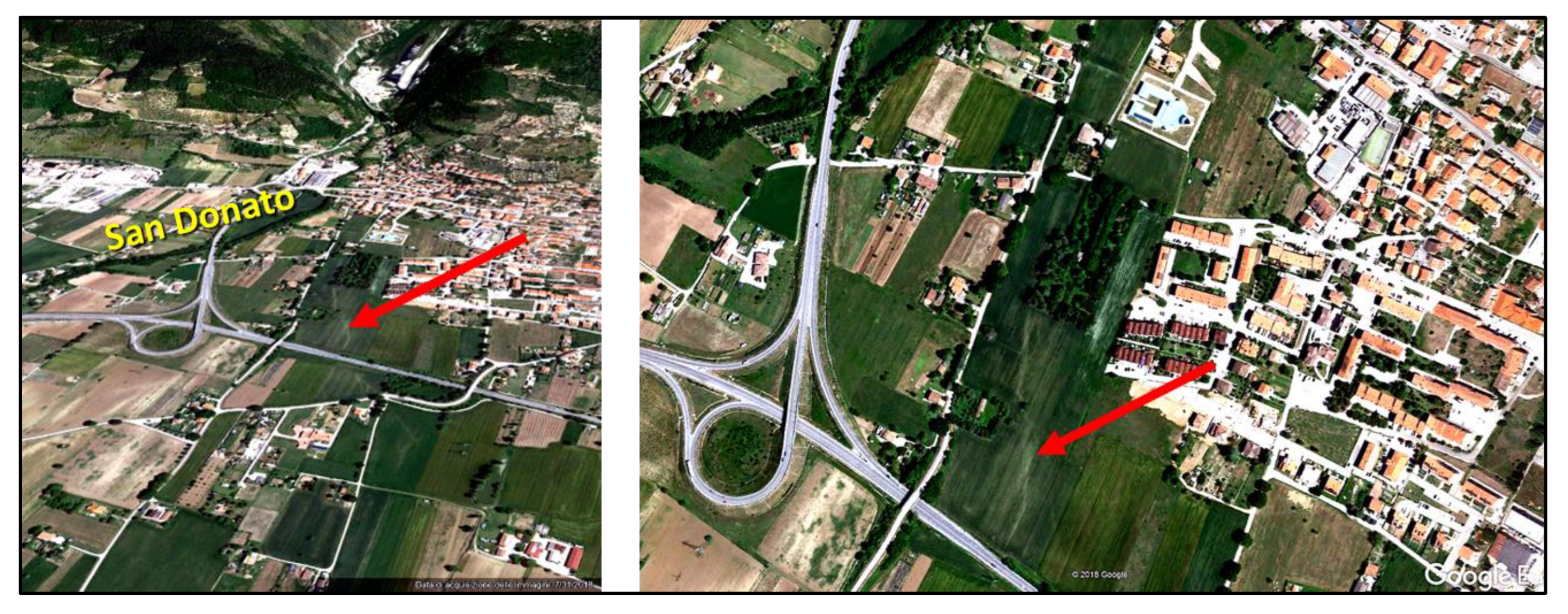
The Causes of the Modification of the Fluvial Track of the San Donato Creek
- a “forced” deviation, artificially induced by hydraulic works in the riverbed, which would therefore have constrained it to modify its track;
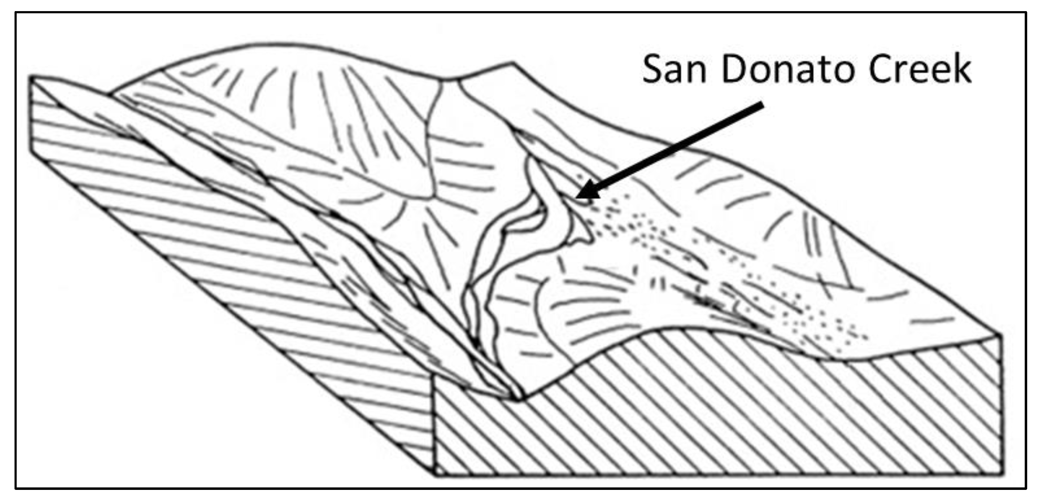
- a natural cause, whereby the stream would have changed direction “spontaneously” caused by a flood event, such as often occur on alluvial fans (such as the one that the San Donato Creek forms), at their mouth on a plain.
4. Discussion
5. Conclusions
Author Contributions
Funding
Data Availability Statement
Acknowledgments
Conflicts of Interest
References
- Williams, G.P.; Wolman, M.G. Downstream Effects of Dams on Alluvial Rivers; U.S. Geological Survey Professional Paper; US Government Printing Office: Washington, DC, USA, 1984. [Google Scholar]
- Wyżga, B. River response to channel regulation: Case study of the Raba River, Carpathians, Poland. Earth Surf. Process. Landf. 1993, 18, 541–556. [Google Scholar] [CrossRef]
- Surian, N.; Rinaldi, M. Morphological response to river engineering and management in alluvial channels in Italy. Geomorphology 2003, 50, 307–326. [Google Scholar] [CrossRef]
- Surian, N.; Rinaldi, M. Channel adjustments in response to human alteration of sediment fluxes: Examples from Italian rivers. In Sediment Transfer through the Fluvial System; Golosov, V., Belyaev, V., Walling, D.E., Eds.; IAHS Publ.: Moscow, Russia, 2004; Volume 288, pp. 276–282. [Google Scholar]
- Romano, S.; Cozzi, M. Cambiamenti nell’uso del suolo: Analisi e comparazione di mappe storiche e recenti. Il caso della Valle dell’Agri, Basilicata, Italia. Aestimum 2007, 51, 63–89. [Google Scholar] [CrossRef]
- Gardi, C.; Dall’Olio, N.; Salata, S. L’insostenibile Consumo di Suolo; EdicomEdizioni: Monfalcone, Italy, 2013. [Google Scholar]
- Consumo di Suolo, Dinamiche Territoriali e Servizi Ecosistemici; Report SNPA 32/22; Munafò, M. (Ed.) ISPRA: Roma, Italy, 2022. [Google Scholar]
- Bravard, J.P.; Kondolf, G.M.; Piegay, H. Environmental and societal effects of channel incision and remedial strategies. In Incised River Channels: Processes, Forms, Engineering and Management; Darby, S.E., Simon, A., Eds.; Wiley: London, UK, 1999; pp. 303–341. [Google Scholar]
- Liebault, F.; Piegay, H. Assessment of channel changes due to long-term bedload supply decrease, Roubion River, France. Geomorphology 2001, 36, 167–186. [Google Scholar] [CrossRef]
- Surian, N. Effects of human impact on braided river morphology: Examples from Northern Italy. In Braided Rivers; Smith, G.H., Best, J.L., Bristow, C., Petts, G.E., Eds.; IAS Special Publication 36; Wiley-Blackwell: Hoboken, NJ, USA, 2006; pp. 327–338. [Google Scholar]
- Da Canal, M.; Comiti, F.; Surian, N.; Mao, L.; Lenzi, M.A. Studio delle variazioni morfologiche del F. Piave nel Vallone Bellunese durante gli ultimi duecento anni. Quad. Di Idronomia Mont. 2007, 27, 259–271. [Google Scholar]
- Surian, N.; Ziliani, L.; Cibien, L.; Cisotto, A.; Baruffi, F. Variazioni morfologiche degli alvei dei principali corsi d’acqua veneto-friulani negli ultimi 200 anni. Alp. Mediterr. Quat. 2008, 21, 279–290. Available online: https://amq.aiqua.it/index.php/amq/article/view/361 (accessed on 2 March 2023).
- Koeman, C. The study of early maps: Methodology—Levels of Historical Evidence in Early Maps (With Examples). Int. J. Hist. Cartogr. 1968, 22, 75–80. [Google Scholar] [CrossRef]
- Kent, A.J. The Value of Historical Maps: Art, Accuracy and Society. Doctoral Thesis, Oxford Brookes University, Oxford, UK, 1998. [Google Scholar] [CrossRef]
- Cencetti, C. La cartografia storica come strumento per lo studio dell’evoluzione degli alvei fluviali. In Proceedings of the 6a Conferenza Nazionale ASITA, Perugia, Italia, 5–8 November 2002; Volume 1, pp. 757–762. [Google Scholar]
- Zámolyi, A.; Székely, B.; Draganits, E.; Timár, G. Historic maps and landscape evolution: A case study in the Little Hungarian Plain. In Proceedings of the European Geosciences Union General Assembly, Vienna, Austria, 19–24 April 2009. [Google Scholar]
- Lambrick, G.; Hind, J.; Wain, I. Historic Landscape Characterisation in Ireland: Best Practice Guidance; The Heritage Council of Ireland Series: Dublin, Ireland, 2013. [Google Scholar]
- Coomans, T. Mapping Landscapes in Transformation: Multidisciplinary Methods for Historical Analysis; Leuven University Press: Leuven, Belgium, 2019. [Google Scholar]
- Sobczynski, D.; Karsznia, I. Landscape evolution in the area of Kazimierski Landscape Park. Pol. Cartogr. Rev. 2019, 51, 81–94. [Google Scholar] [CrossRef] [Green Version]
- Rombai, L. Problems related to the use of the history cartography. Boll. Ass. It. Cart. 2010, 138, 69–89. [Google Scholar]
- Statuto, D.; Cillis, G.; Picuno, P. Using Historical Maps within a GIS to Analyze Two Centuries of Rural Landscape Changes in Southern Italy. Land 2017, 6, 65. [Google Scholar] [CrossRef] [Green Version]
- Branduini, P.; Laviscio, R.; L’Erario, A.; Toso, F.C. Mapping Evolving Historical Landscape System. In Proceedings of the 2nd International Conference of Geomatics and Restoration, Milan, Italy, 8–10 May 2019; pp. 277–284. [Google Scholar]
- Picuno, P.; Cillis, G.; Statuto, D. Investigating the time evolution of a rural landscape: How historical maps may provide environmental information when processed using a GIS. Ecol. Eng. 2019, 139, 105580. [Google Scholar] [CrossRef]
- Piovan, S. Historical Maps in GIS. In The Geographic Information Science & Technology Body of Knowledge, 1st Quarter 2019 Ed.; Wilson, J.P., Ed.; Digital version; UCGIS: Ithaca, NY, USA, 2019. [Google Scholar] [CrossRef]
- Allegrucci, F. Lettura cartografica dell’Eugubino dalla Carta del Georgi a quella del Coronelli. In Gubbio e la sua Storia – Sez. III. Gubbio nel Rinascimento; Biblioteca Sperelliana: Gubbio, Italia, 1999; 7p. [Google Scholar]
- Ambrosetti, P.; Basilici, G. Il Plio-Pleistocene Umbro. In Guide Geologiche Regionali. Appennino Umbro-Marchigiano (Società Geologica italiana), 1st ed.; BE.MA.: Milano, Italy, 1994; pp. 46–47. [Google Scholar]
- Elter, P.; Giglia, G.; Tongiorgi, M.; Trevisan, L. Tensional and compressional areas in the recent (Tortonian to Present) evolution of the Northern Apennines. Boll. Geofis. Teor. Appl. 1975, 65, 3–18. [Google Scholar]
- Carmignani, L.; Kligfield, R. Crustal extension in the Northern Apennines: The transition from compression to extension in the Alpi Apuane core complex. Tectonics 1990, 9, 1275–1303. [Google Scholar] [CrossRef]
- Boccaletti, M.; Cerrina Feroni, A.; Martinelli, P.; Moratti, G.; Plesi, G.; Sani, F. L’alternanza distensione-compressione nel quadro evolutivo dei bacini neogenici dell’Appennino Settentrionale. In Studi Preliminari All’acquisizione Dati del Profilo CROP 03 Punta Ala—Gabicce; Pialli, G., Barchi, M., Menichetti, M., Eds.; Studi Geologici Camerti; Università di Camerino: Camerino, Italy, 1991; pp. 187–192. [Google Scholar]
- Cinque, A.; Patacca, E.; Scandone, P.; Tozzi, M. Quaternary kinematic evolution of the Southern Apennines. Relationships between surface geological features and deep lithospheric structures. Ann. Geofis. 1993, 36, 249–260. [Google Scholar] [CrossRef]
- Amato, A.; Selvaggi, G. Terremoti crostali e sub-crostali nell’Appennino settentrionale. In Studi Preliminari All’acquisizione Dati del Profilo CROP 03 Punta Ala—Gabicce; Pialli, G., Barchi, M., Menichetti, M., Eds.; Studi Geologici Camerti; Università di Camerino: Camerino, Italy, 1991. [Google Scholar]
- Boncio, P.; Brozzetti, F.; Ponziani, F.; Barchi, M.; Lavecchia, G.; Pialli, G. Seismicity and extensional tectonics in the northern Umbria-Marche Apennines. Mem. Soc. Geol. It 1998, 52, 55. [Google Scholar]
- Barchi, M.; Beltrando, M. The Neogene-Quaternary evolution of the Northern Apennines: Crustal structure, style of deformation and seismicity. J. Virtual Explor. 2010, 36, 1–24. [Google Scholar] [CrossRef]
- Collettini, C.; Barchi, M.; Chiaraluce, L.; Mirabella, F.; Pucci, S. The Gubbio fault: Can different methods give pictures of the same object? J. Geodyn. 2003, 36, 51–66. [Google Scholar] [CrossRef]
- Menichetti, M.; Minelli, G. Extensional tectonics and seismogenesis in Umbria (Central Italy) the Gubbio area. Boll. Soc. Geol. It. 1991, 110, 857–880. [Google Scholar]
- Cattuto, C.; Cencetti, C.; Gregori, L. Elementi geomorfologici dell’area compresa tra l’Umbria nord-orientale e la regione marchigiana. Mem. Descr. Della Carta Geol. D’italia 1989, 39, 37–44. [Google Scholar]
- Cattuto, C.; Cencetti, C.; Gregori, L. Il Plio-Pleistocene nell’area medio-alta del bacino del F. Tevere: Possibile modello morfotettonico. Studi Geol. Camerti 1992, 103–108. [Google Scholar]
- Cencetti, C. Evoluzione del reticolo idrografico in un tratto umbro-marchigiano dello spartiacque principale dell’Appennino. Geogr. Fis. Dinam. Quat. 1988, 11, 11–24. [Google Scholar]
- Sestini, A. Sull’origine della rete idrografica e dei bacini intermontani nell’Appennino centro-settentrionale. Riv. Geogr. It. 1950, 57, 249–256. [Google Scholar]
- Desplanques, H. Carte du peuplement dans la région de Gubbio au XVIe siècle. Mediterranèe 1963, 4, 5–13. [Google Scholar] [CrossRef]
- Allegrucci, F. La popolazione della diocesi di Gubbio in una carta topografica del XVI secolo. Propos. E Ric. 1985, 15, 51–60. [Google Scholar]
- Armeni, C.; Falcucci, C. Museo Comunale di Gubbio. Incisioni; Electa: Firenze, Italy, 1993; 156p. [Google Scholar]
- Graziani, M.O. La Carta del Georgi; L’Arte Grafica: Gubbio, Italy, 2005; 28p. [Google Scholar]
- Menichetti, P.L. Storia di Gubbio Dalle Origini all’Unità d’Italia; Petruzzi Editore: Città di Castello, Italy, 1987; Volume 2, pp. 94–95. [Google Scholar]
- Charalambous, K.; Bruggeman, A.; Bakirtzis, N.; Lange, M.A. Historical Flooding of the Pedieos River in Nicosia, Cyprus. Water Hist. 2016, 8, 191–207. [Google Scholar] [CrossRef]
- Sannipoli, E.A. Documenti inediti su Jacopo Bedi pittore eugubino (1a parte). Gubbio Arte 1994, 12, 21–23. [Google Scholar]
- Paci, R. La crisi del Comune popolare di Gubbio nel Cinquecento. Quad. Stor. Delle Marche 1967, 2, 457–507. [Google Scholar]
- Biscarini, P.E.P. Splendore e decadenza di una città: Gubbio tra la fine del Quattrocento e la prima metà del Cinquecento. Alcune note di storia. In Proceedings of the La maiolica Italiana del Cinquecento. Il Lustro Eugubino e L’istoriato del Ducato di Urbino, Gubbio, Italy, 21–23 September 1998; Centro Di: Firenze, Italy, 2002; pp. 31–48. [Google Scholar]
- Cece, F.; (Independent Researcher, Gubbio, Italy). Personal communications. 2020. [Google Scholar]
- Panizza, M. Elementi di Geomorfologia; Pitagora: Bologna, Italy, 1978; 188p. [Google Scholar]
- Luongo, A. Gubbio nel Trecento. Il comune Polare e la Mutazione Signorile (1300–1404); Viella: Roma, Italy, 2016; 726p. [Google Scholar]
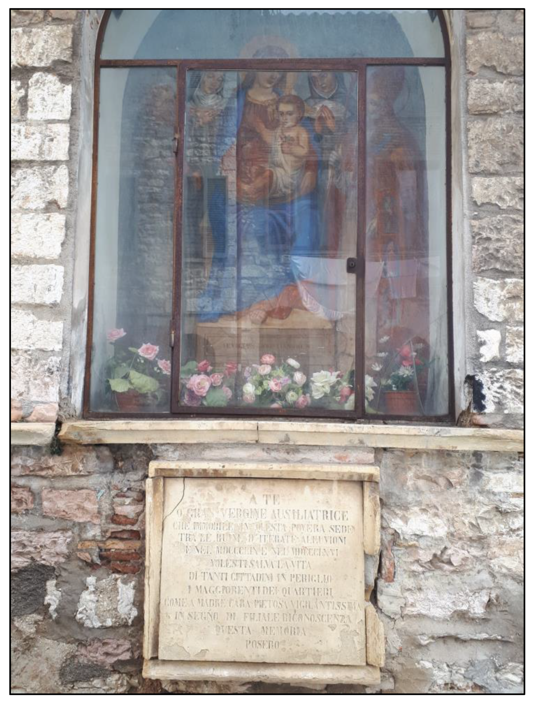
- Cece, F. Memorie di don Paris Montanari. In Il Diario di Giacomo Armanni (1622–1631). Gubbio Negli Ultimi Dieci Anni del Ducato di Urbino; Self-Published: Gubbio, Italy, 2006; pp. 53–62. [Google Scholar]
- Cece, F. Luigi Lucarelli. Memorie; Media Video: Gubbio, Italy, 2011; 400p. [Google Scholar]


| Title | Author | Year | Location | Notes |
|---|---|---|---|---|
| Tavola Nuova della Marca d’Ancona | Girolamo Ruscelli | 1561 | In: “Geographia” of Claudio Tolomeo | printed |
| Novo et vero dissegno della Marca di Ancona con li sui confini | Ferrando Bertelli | 1565 | British Museum, London | printed |
| Marcha Anconae olim Picenum | Abramo Ortelio | 1572 | Municipal Library of Fermo | printed |
| Urbini Ducatus | Egnatio Danti | 1580–1582 | Vatican Museums | wall painting |
| Marchia Anconitana cum Spoletano Ducatu | Gerhard Mercatore | 1589 | private collection | printed |
| Ducatus Urbini nova et exacta descriptio | Abramo Ortelio | 1606 | “Federiciana” Library of Fano | printed |
| Marca d’Ancona olim Picenum | Giovanni Antonio Magini | 1620 | “Oliveriana” Library of Pesaro | printed |
| Urbini Ducatus | Giovanni Antonio Magini | 1620 | “Federiciana” Library of Fano | printed |
| Gli Stati dei Serenissimi Duchi della Rovere | Francesco Mingucci | 1626 | Vatican manuscript code 4434 | hand drawn |
| Urbini Ducatus | Jodoco Hondio | 1627 | “Federiciana” Library of Fano | printed |
| Stato d’Urbino | Marco Ferrante Gerlassa | circa 1630 | National Gallery of Marche, Urbino | hand drawn |
| Ducato di Urbino | Henricus Hondius | 1635 | “Federiciana” Library of Fano | printed |
| Marchia Anconitana olim Picenum | Henricus Hondius | 1640 | Municipal Library of Civitanova Marche | printed |
| Legatione del Ducato d’Urbino | Filippo Titi | 1697 | “Federiciana” Library of Fano | printed |
| Marca d’Ancona | Vincenzo Coronelli | 1708 | Franciscan and Picene Historical Library of Falconara | printed |
| Provincia Piceni | Giovanni di Montecavallero | 1711 | Franciscan and Picene Historical Library of Falconara | printed |
| Marca Anconae, olim Picenum | Lasor a Varea | 1713 | “Federiciana” Library of Fano | printed |
| Ducato d’Urbino | 1723 | In: “Memorie istoriche concernenti la Devoluzione dello Stato di Urbino alla Santa Sede Apostolica” (Riveriana) | printed | |
| Nuova Carta Geografica dello Stato Ecclesiastico | Ruđer Josip Bošković e Christoper Maire | 1755 | National Library of Florence | printed |
| Nuova Delineazione della Legazione di Urbino | Christoper Maire | 1757 | “Oliveriana” Library of Pesaro | printed |
| Catasto geometrico-particellare del territorio di Gubbio | Giuseppe Maria Ghelli | 1768 | State Archive Section of Gubbio | 27 hand drawn maps and 48 “brogliardi” (descriptive registers) |
| Lo Stato della Chiesa | Antonio Zatta | 1782 | Franciscan and Picene Historical Library of Falconara | printed |
| Legazione d’Urbino e Governo di Città di Castello | Antonio Zatta | 1783 | Franciscan and Picene Historical Library of Falconara | printed |
| Catasto gregoriano | AA.VV. | 1816–1835 | State Archive of Perugia | unit 287, hand drawn |
| Data | Fonte | Note |
|---|---|---|
| 1388 ca. | Luongo [51], 1.11 | Flood of Camignano River |
| 18 July 1571 | Montanari, Memorie [52] | Flood of Camignano River |
| 20 October 1613 | SASG, Fondo Pesci, n. 12, p. 696 | Flood of Camignano River |
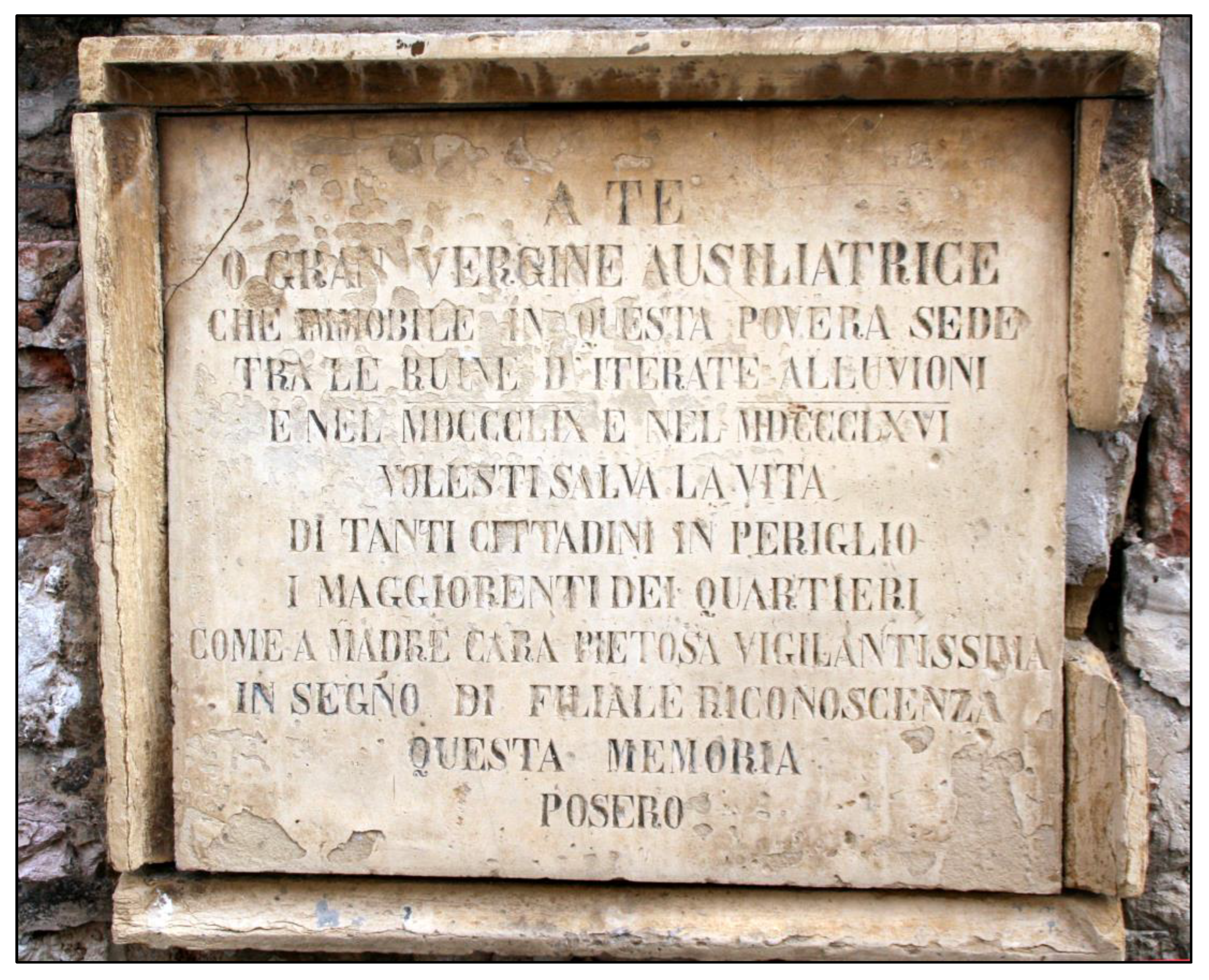
| 25 August 1616 | SASG, Fondo Pesci, b. 12, Effemeridi Orsaioli, p. 446 | Great flood of San Donato Creek |
| September 1619 | SASG, Fondo Pesci, n. 12, p. 505 | Flood of Camignano River |
| 3 June 1772 | SASG, Fondo Comunale, Registri Parrocchiali (san Giovanni e sant’Agostino) | “per impetuosa pioggia si rompì […] il Bottaccione”; flood and damages in Gubbio, 9 dead |
| End of July, 1792 | Cece, personal communication, 2020 | Flood of Camignano River |
| 8 September 1835 | Lucarelli, Memorie [53], pp. 196–197 | “Tutti i fiumi hanno straripato in modo tale che non vi era memoria di casi simili”; flood of Camignano River and other streams |
| 18 September 1859 | Lucarelli, Memorie [53], p. 344 | “il debordamento de fiumi ha recato immensi danni non solo nelle campagne, ma benanche in città”; generalized floods |
| 26 May 1866 | ADG, Fondo del Capitolo dei Canonici, I.C. 21, p. 136 | Flood of Camignano River |
Disclaimer/Publisher’s Note: The statements, opinions and data contained in all publications are solely those of the individual author(s) and contributor(s) and not of MDPI and/or the editor(s). MDPI and/or the editor(s) disclaim responsibility for any injury to people or property resulting from any ideas, methods, instructions or products referred to in the content. |
© 2023 by the authors. Licensee MDPI, Basel, Switzerland. This article is an open access article distributed under the terms and conditions of the Creative Commons Attribution (CC BY) license (https://creativecommons.org/licenses/by/4.0/).
Share and Cite
Cencetti, C.; Paciotti, F.; Sannipoli, E.A.; Scavizzi, U.E. The Multidisciplinary Approach in the Study of Landscape Evolution: The Fluvial Capture of the San Donato Creek (Gubbio, Central Italy), an Example of Hydrological Regime and Hydrogeological Risk Changes. Land 2023, 12, 694. https://doi.org/10.3390/land12030694
Cencetti C, Paciotti F, Sannipoli EA, Scavizzi UE. The Multidisciplinary Approach in the Study of Landscape Evolution: The Fluvial Capture of the San Donato Creek (Gubbio, Central Italy), an Example of Hydrological Regime and Hydrogeological Risk Changes. Land. 2023; 12(3):694. https://doi.org/10.3390/land12030694
Chicago/Turabian StyleCencetti, Corrado, Filippo Paciotti, Ettore A. Sannipoli, and Ubaldo E. Scavizzi. 2023. "The Multidisciplinary Approach in the Study of Landscape Evolution: The Fluvial Capture of the San Donato Creek (Gubbio, Central Italy), an Example of Hydrological Regime and Hydrogeological Risk Changes" Land 12, no. 3: 694. https://doi.org/10.3390/land12030694