

Where the Second World War in Europe Broke Out: The Landscape History of Westerplatte, Gdańsk/Danzig

Abstract
:1. Introduction
Literature Review
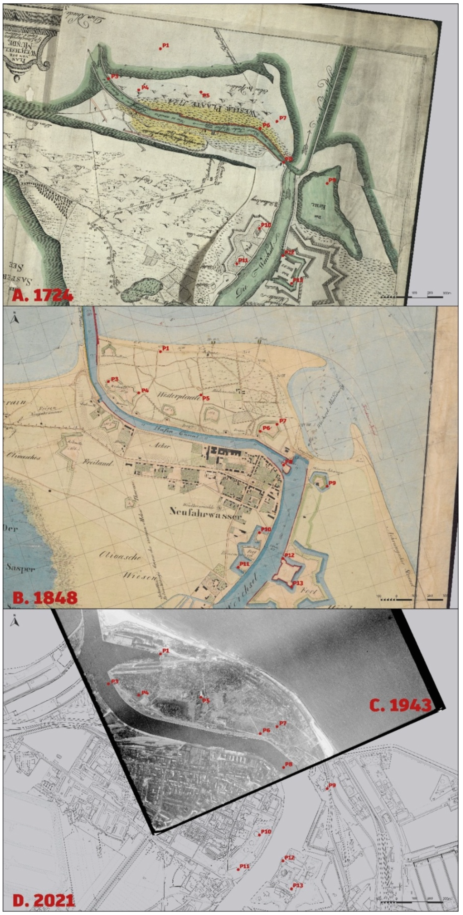
2. Methods
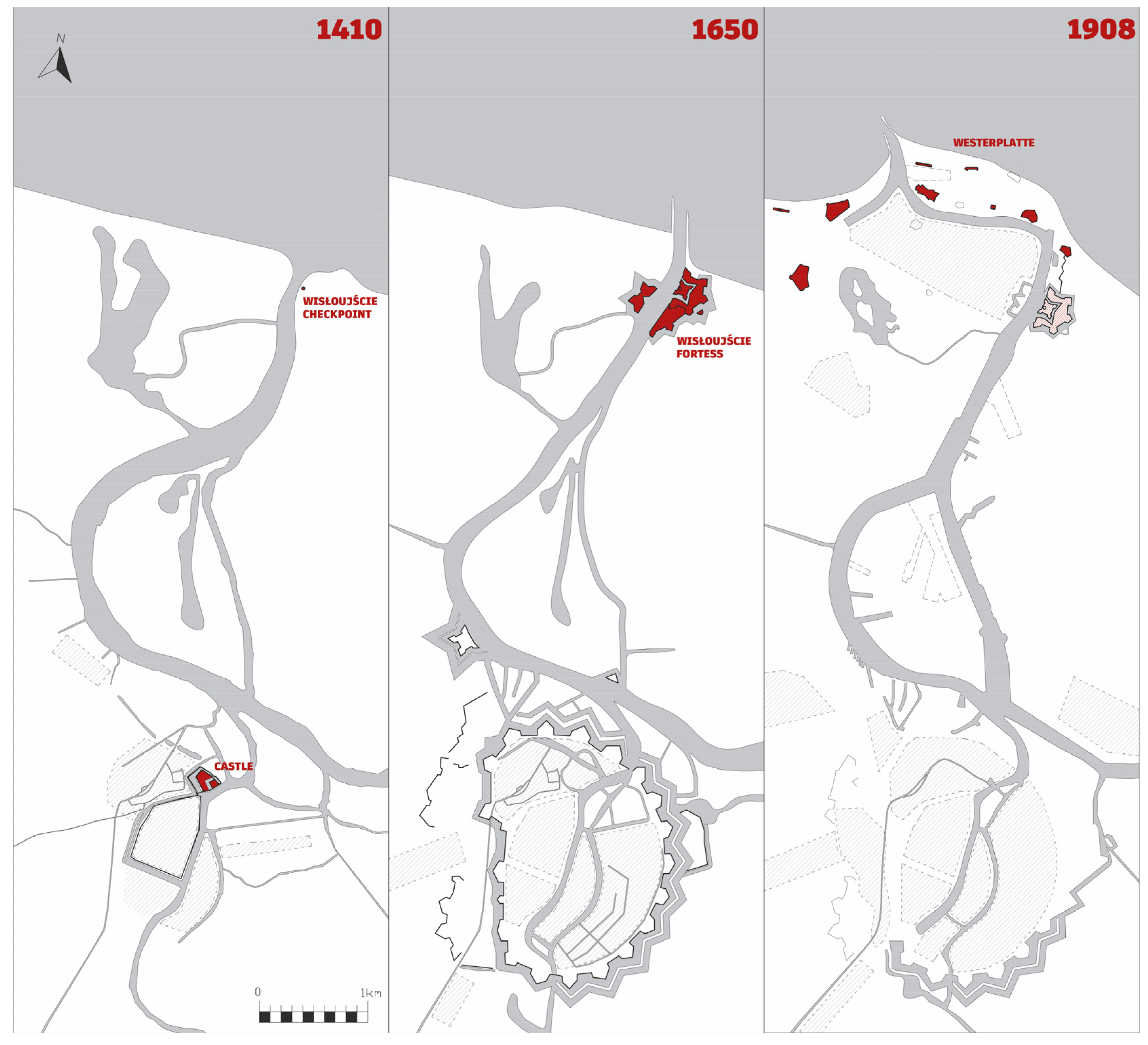
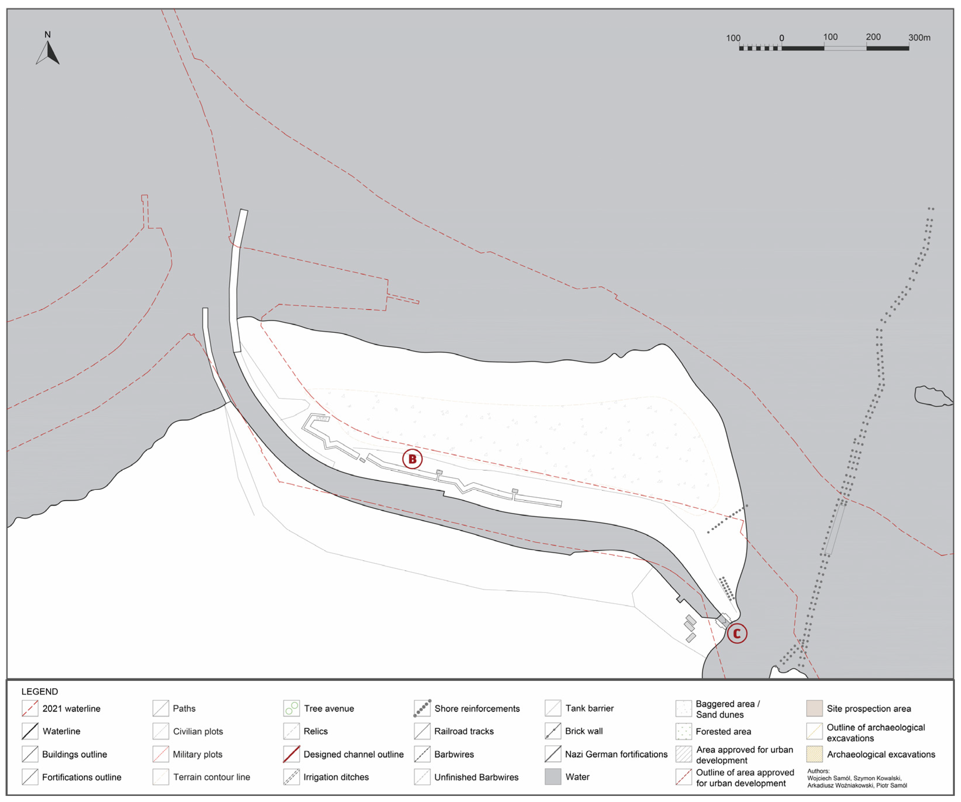
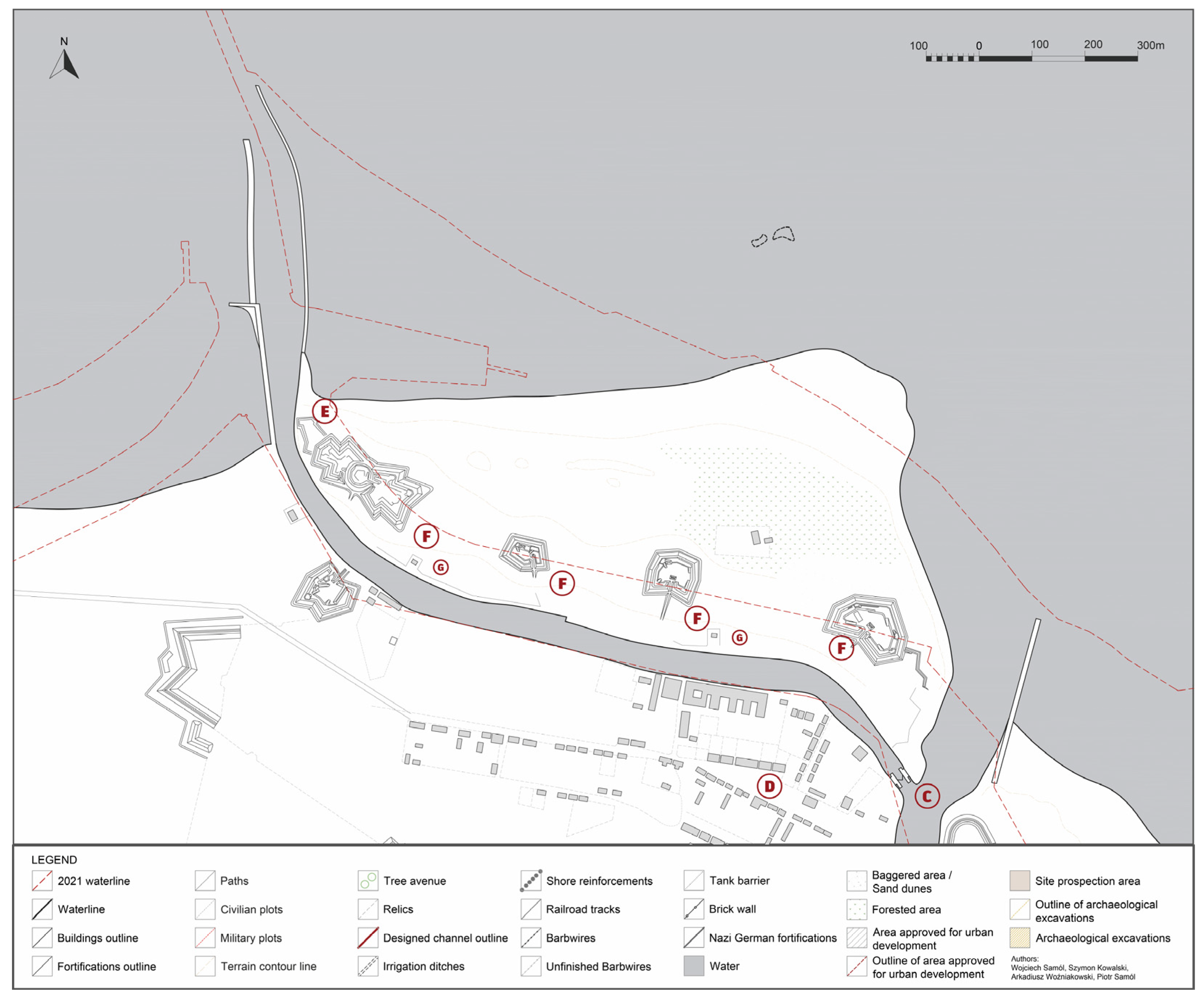
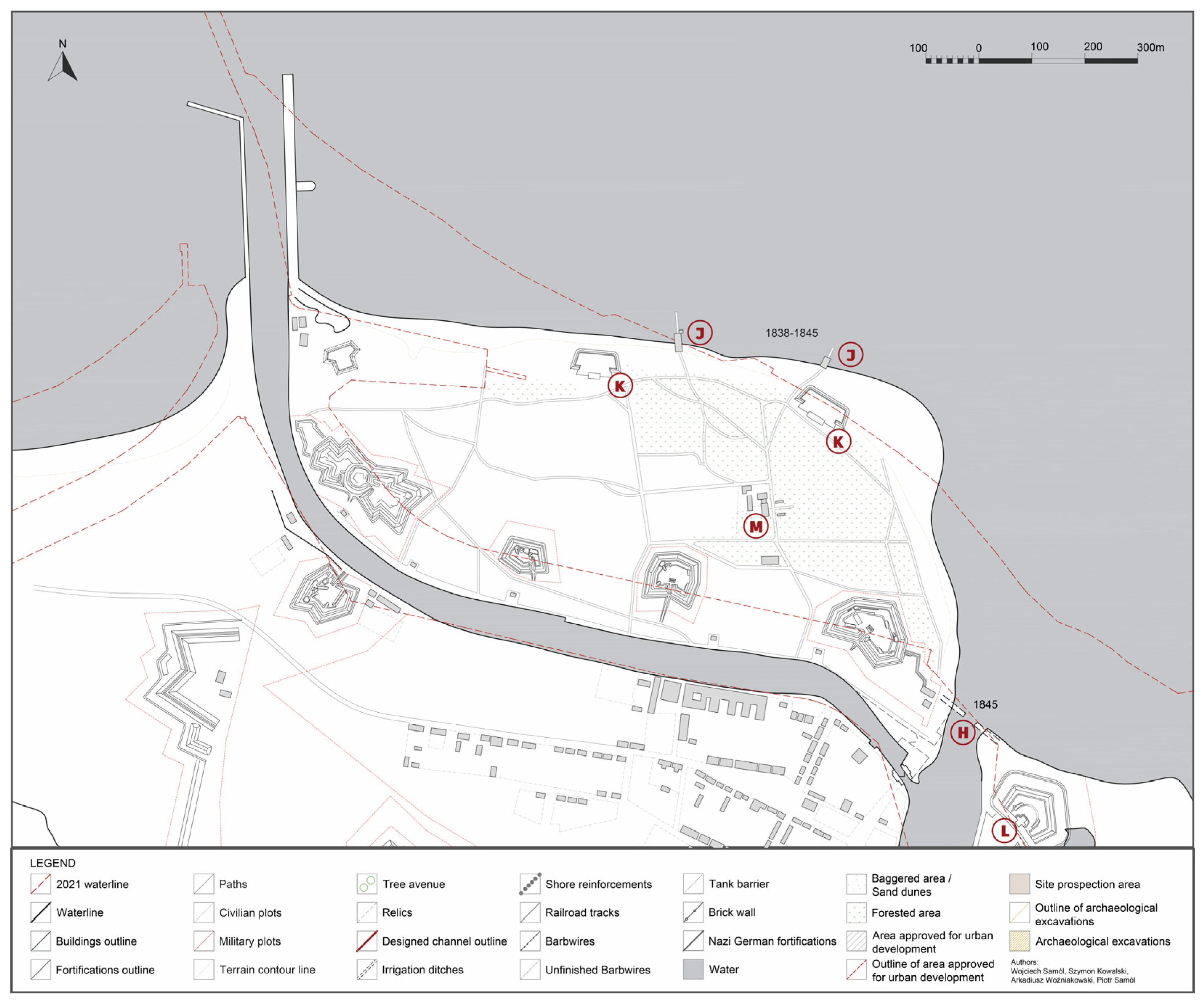
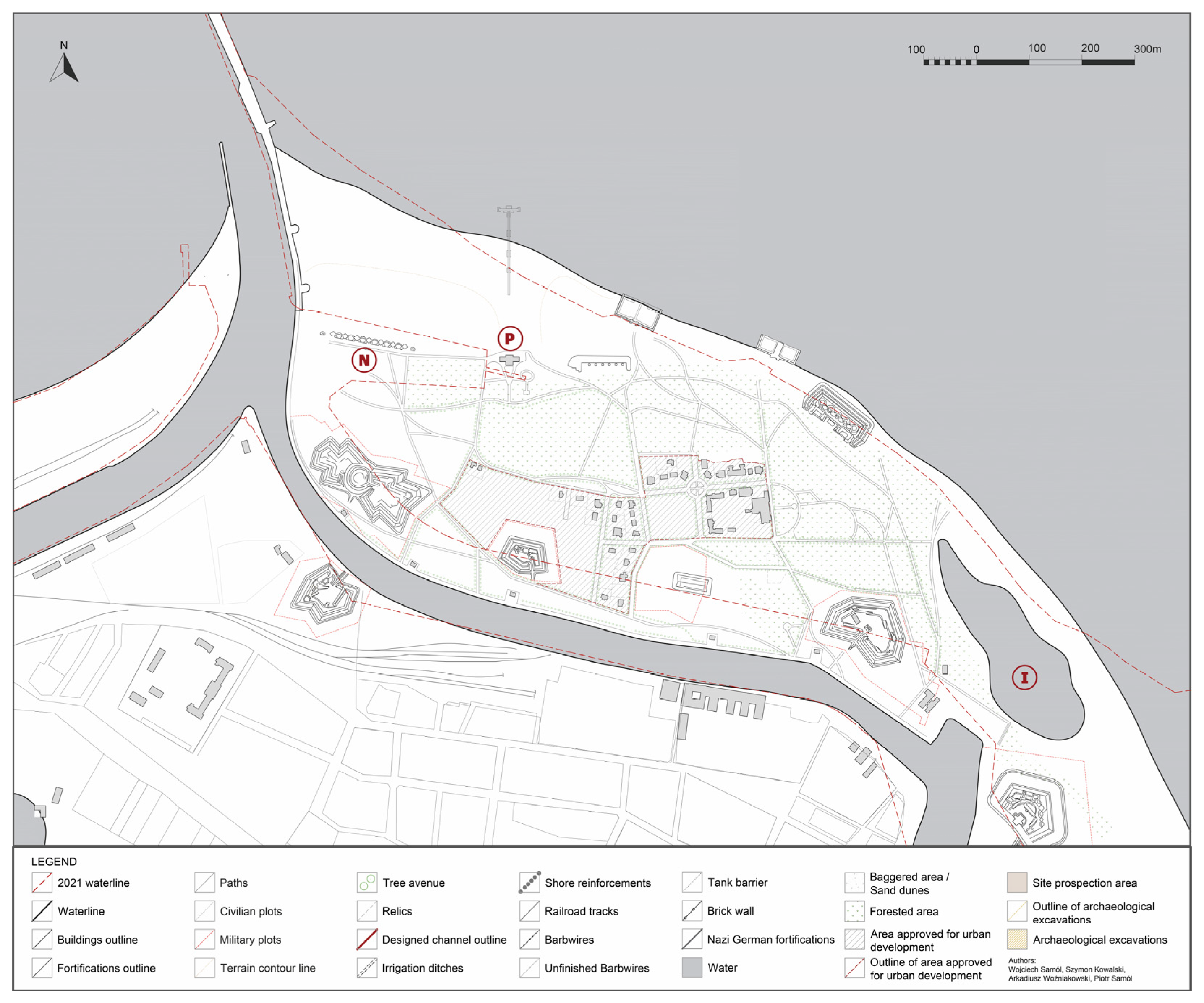
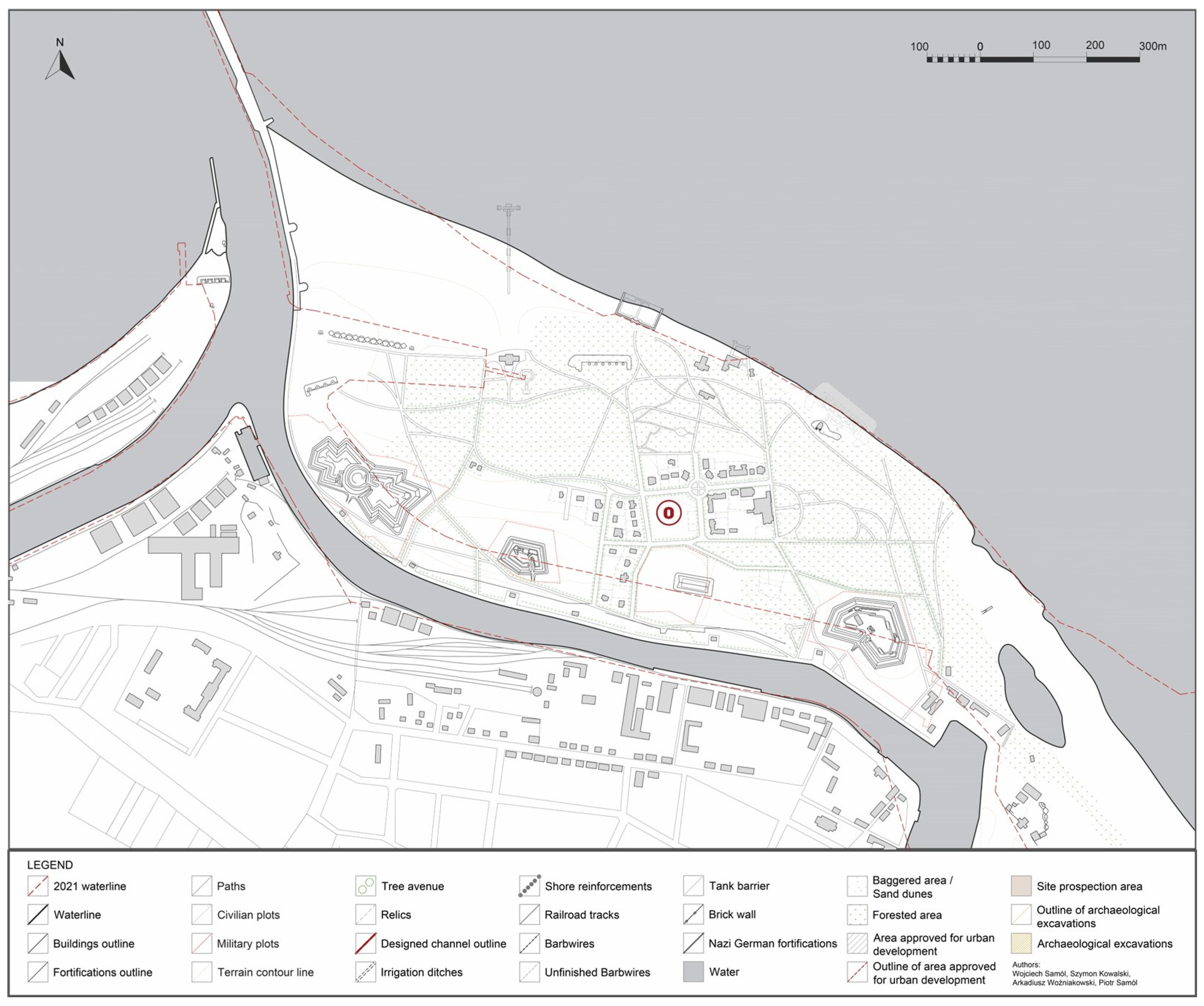
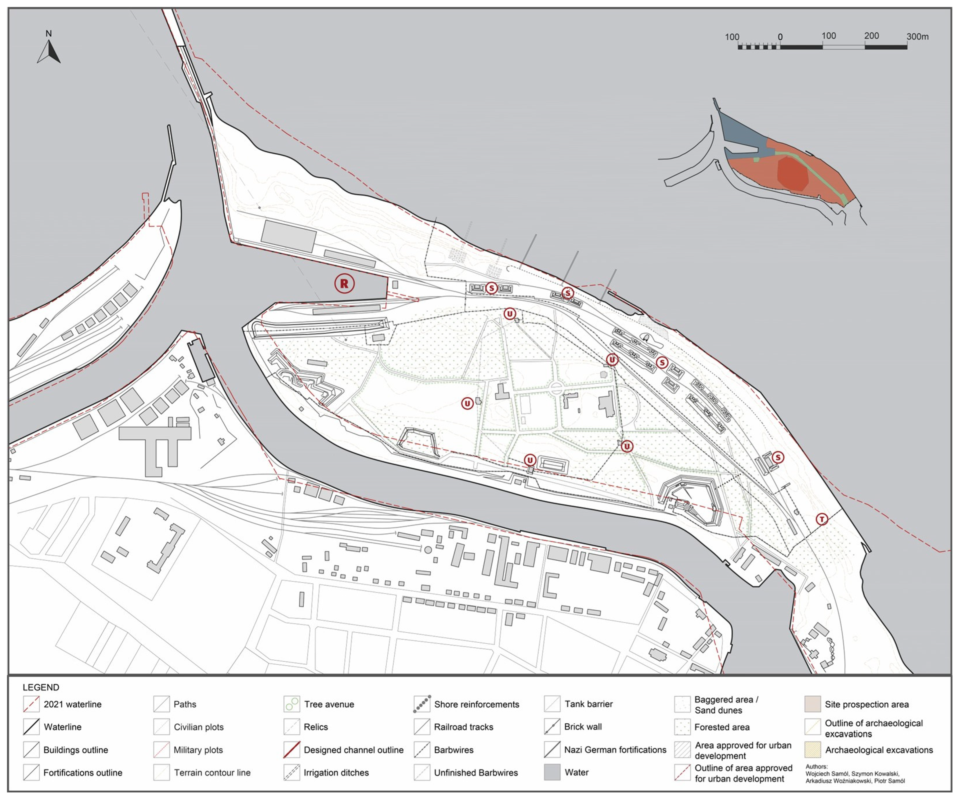
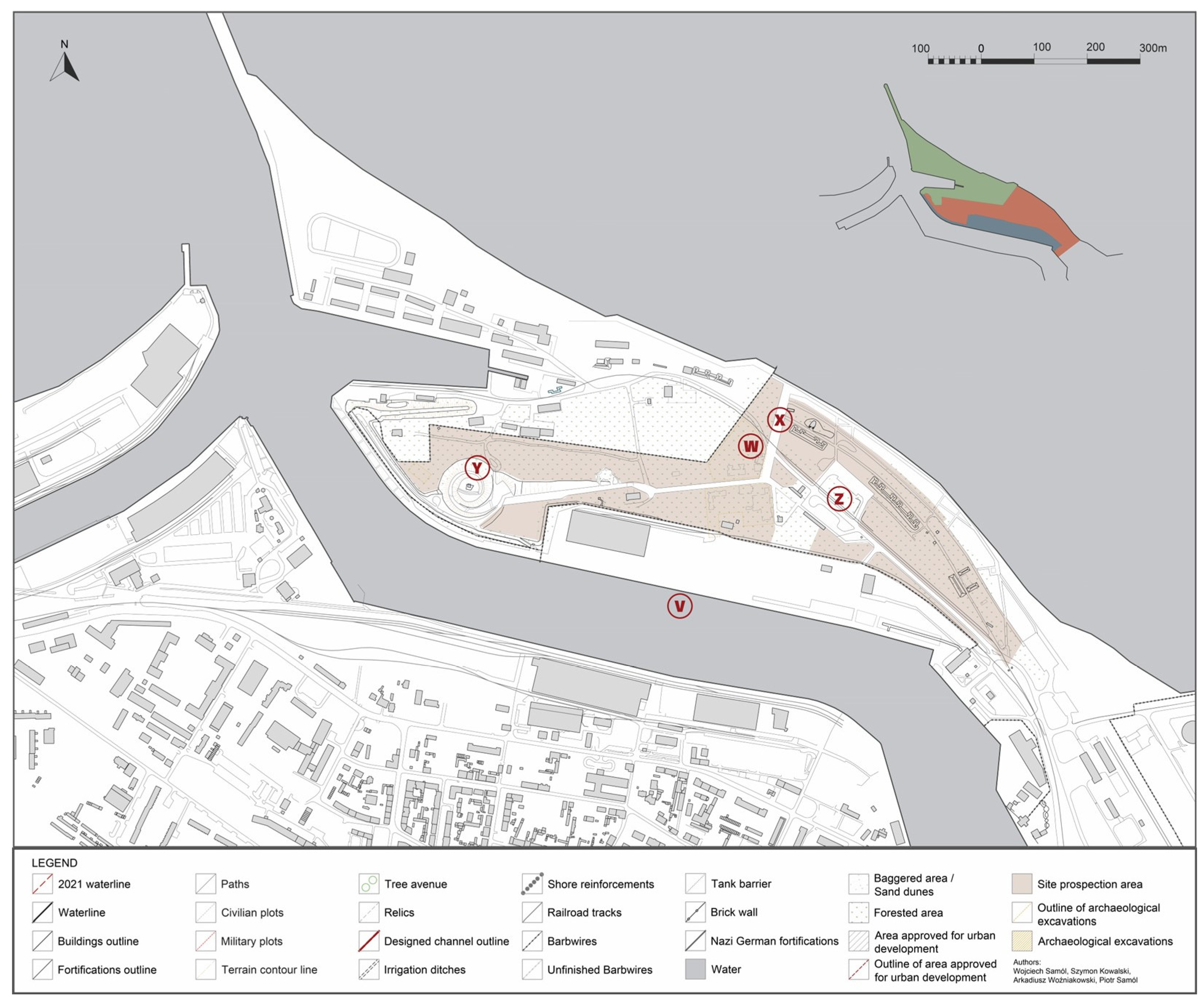
3. Results—Spatial Transformations of Westerplatte
3.1. Stage 1: 1698–1737
3.2. Stage 2: 1772–1806
3.3. Stage 3: 1807–1814
3.4. Stage 4: 1828–1870
3.5. Stage 5: 1880–1914
3.6. Stage 6: 1914–1918/1923
3.7. Stage 7: 1926–1939
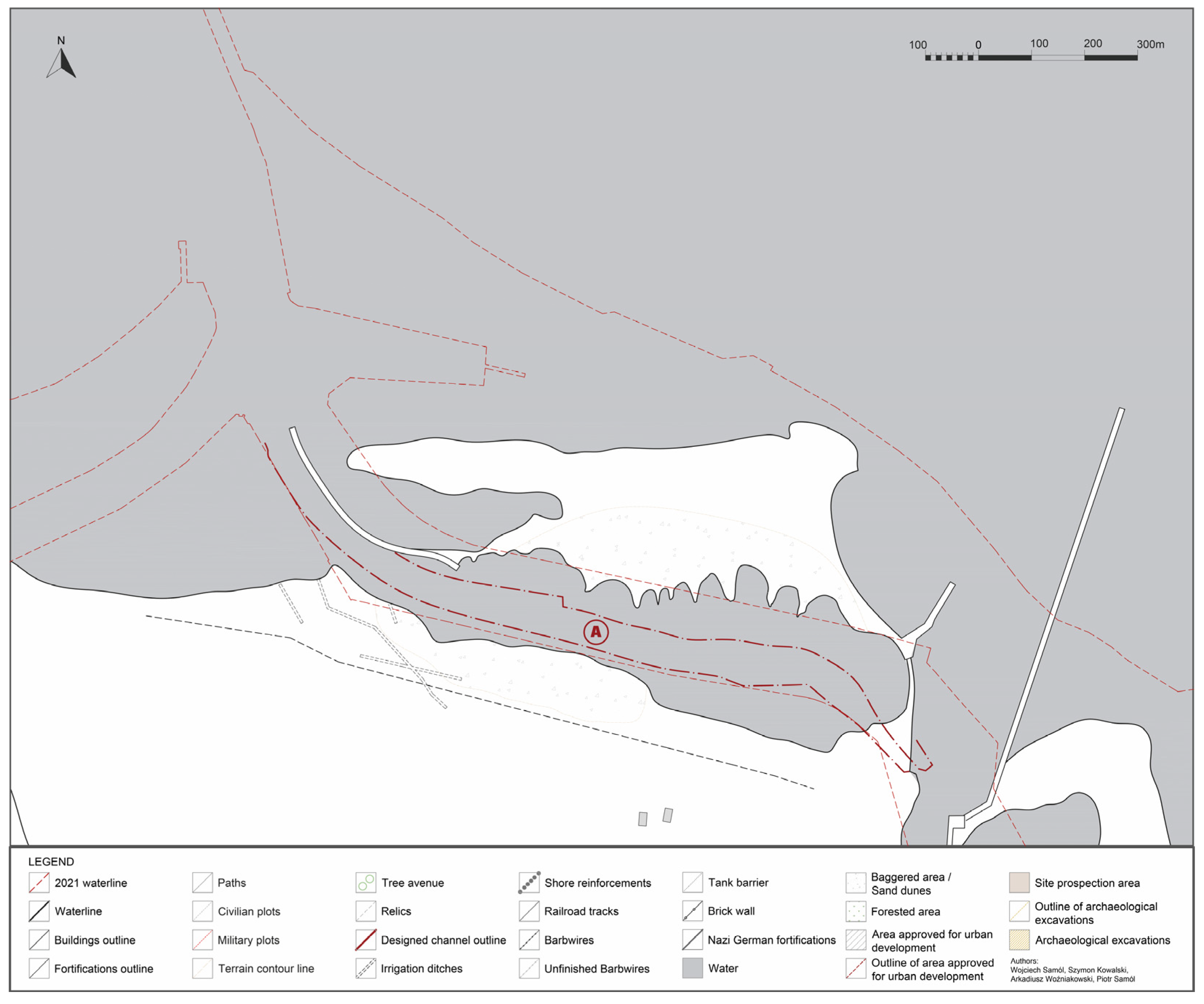
3.8. Stage 8: 1939–1945
3.9. Stage 9: 1963–1966
3.10. Perspectives
4. Discussion
5. Conclusions
Author Contributions
Funding
Data Availability Statement
Conflicts of Interest
References
- Davis, N. No Simple Victory. In World War II in Europe 1939–1945; Penguin Books: New York, NY, USA, 2008. [Google Scholar]
- Biernat, C.; Cieślak, E. History of Gdansk; Wydawnictwo Morskie: Gdańsk, Poland, 1995. [Google Scholar]
- Drzycimski, A. Westerplatte 1939. Przed Szturmem; Słowo/ObrazTerytoria: Gdańsk, Poland, 2009. [Google Scholar]
- Drzycimski, A. Westerplatte: Reduta w Budowie; Fundacja Gdańska: Gdańsk, Poland, 2014. [Google Scholar]
- Drzycimski, A. Westerplatte: Reduta Wojenna; Fundacja Gdańska: Gdańsk, Poland, 2014. [Google Scholar]
- Drzycimski, A. Westerplatte. Kulisy Niemieckiej Wojny Propagandowej; Muzeum Gdańska: Gdańsk, Poland, 2019. [Google Scholar]
- Błyskosz, T. Westerplatte—Przekształcenia Pola Bitwy Po 1945 r. (Do Początku XXI w.). In Materialne Pozostałości Konfliktów i Zbrodni XX Wieku w Świetle Najnowszych Badań Archeologicznych; Mik, H., Węglińska, W., Eds.; Muzeum Drugiej Wojny Światowej: Gdańsk, Poland, 2019; pp. 342–362. [Google Scholar]
- Snyder, T. Poland vs. History. The New York Review of Books. 3 May 2016. Available online: https://www.nybooks.com/online/2016/05/03/poland-vs-history-museum-gdansk/ (accessed on 31 August 2022).
- Brandolini, P.; Cappadonia, C.; Luberti, G.M.; Donadio, C.; Stamatopoulos, L.; Di Maggio, C.; Faccini, F.; Corrado, S.; Vergari, F.; Paliaga, G.; et al. Geomorphology of Anthropocene in Miditerranean urban areas. Prog. Phys. Geogr. Earth Environ. 2019, 44, 461–494. [Google Scholar] [CrossRef]
- Del Monte, G.; D’Orefice, M.; Luberti, G.M.; Marini, G.; Pica, A.; Vergari, F. Geomorphological classification of urban landscapes: The case study of Rome (Italy). J. Maps 2016, 12, 178–189. [Google Scholar] [CrossRef] [Green Version]
- Zwoliński, Z.; Hildebrandt-Radke, I.; Mazurek, M.; Makohonienko, M. Anthropomorphological metamorphosis of an urban area in the Postglacial landscape: A case study of Poznań city. In Urban Geomorphology, Landforms and Process in the Cities; Thornbushand, M.J., Allen, C.D., Eds.; Elsevier: Amsterdam, The Netherlands, 2018; pp. 55–77. [Google Scholar]
- Šantrůčková, M.; Salašová, A.; Sokolová, K.; Sedlacek, J. Mapping military landscape as a cultural heritage: Case study of the Austerlitz/Slavkov battlefield site. AUC Geogr. 2020, 55, 66–76. [Google Scholar] [CrossRef] [Green Version]
- De Matos-Machado, R.; Arnaud-Fassetta, G.; Batard, F.; Bilodeau, C.; Jacquemot, S.; Amat, J.-P. Warfare as a new field of study in archaeo-geomorphology: The case of the battlefield of Verdun (France). In Proceedings of the 6th Young Geomorphologists’ Day the Geomorphology for Society from Risk Knowledge to Landscape Heritage, Cagiliari, Italy, 28–30 September 2015; Available online: https://www.academia.edu/32801630/Warfare_as_a_new_field_of_study_in_archaeo_geomorphology_The_case_of_the_battlefield_of_Verdun_France_ (accessed on 21 December 2022).
- Uribe, P.; Angás, J.; Romeo, F.; Pérez-Cabello, F.; Santamaría, D. Mapping Ancient Battlefields in a multi-scalar approach combining Drone Imagery and Geophysical Surveys: The Roman siege of the oppidum of Cabezo de Alcalá (Azaila, Spain). J. Cult. Herit. 2021, 48, 11–23. [Google Scholar] [CrossRef]
- Gheyle, W.; Stichelbaut, B.; Saey, T.; Note, N.; Van den Berghe, H.; Van Eetvelde, V.; Van Meirvenne, M.; Bourgeois, J. Scratching the surface of war. Airborne laser scans of the Great War conflict landscape in Flanders (Belgium). Appl. Geogr. 2018, 90, 55–68. [Google Scholar] [CrossRef]
- Dziewanowski, A.; Kuczma, F.; Samól, W. BadaniaArcheologiczne. Pola Bitwy Na Westerplatte. WynikiPracProwadzonych w Latach 2016–2017. In Materialne Pozostałości Konfliktów i Zbrodni XX Wieku w Świetle Najnowszych Badań Archeologicznych; Mik, H., Węglińska, W., Eds.; Muzeum Drugiej Wojny Światowej: Gdańsk, Poland, 2019; pp. 235–274. [Google Scholar]
- Spennemann, D.H.R.; Poynter, C. Using 3D Spatial Visualisation to Interpret the Coverage of Anti-Aircraft Batteries on a World War II Battlefield. Heritage 2019, 2, 2457–2479. [Google Scholar] [CrossRef] [Green Version]
- Briaud, J.-L. Normandy cliff stability: Analysis and repair. In Geomechanics and Geodynamics of Rock Masses, Proceedings of the 2018 European Rock Mechanics Symposium, St. Petersburg, Russia, 22–26 May 2018; Litvinenko, V., Ed.; CRC Press: London, UK, 2019; pp. 611–616. [Google Scholar]
- Altizer, W.E. Time Perspectivism, Temporal Dynamics, and Battlefield Archaeology: A Case Study from the Santiago Campaign of 1898. Neb. Anthropol. 2008, 36, 62–79. [Google Scholar]
- Bandarin, F.; Van Oers, R. (Eds.) Reconnecting the City: The Historic Urban Landscape Approach and the Future of Urban Heritage; John Wiley and Sons: Oxford, UK, 2015. [Google Scholar]
- Taylor, K. The Historic Urban Landscape Paradigm and Cities as Cultural Landscapes. Challenging Orthodoxy in Urban Conservation. Landsc. Res. 2016, 41, 471–480. [Google Scholar] [CrossRef]
- Giliberto, F.; Appendino, F. Handling change in historic urban landscapes: An analysis of urban heritage conservation approaches in Bordeaux (France), Edinburgh (UK) and Florence (Italy). In Landscape as Heritage. International Critical Perspectives; Pettenati, G., Ed.; Routledge: Abingdon, UK; New York, NY, USA, 2023; pp. 216–230. [Google Scholar]
- Balletti, C. Georeference in the Analysis of the Geometric Content of Early Maps. E-Perimetron 2006, 1, 32–42. [Google Scholar]
- Huffman, K.L.; Giordano, A.; Bruzelius, C. (Eds.) Visualizing Venice; Routledge: New York, NY, USA, 2017. [Google Scholar]
- Bruzelius, C.; Tronzo, W. Medieval Naples; Italica Press: New York, NY, USA, 2011. [Google Scholar]
- Mapping Historical New York City A Collaboration to Map Immigration and Neighbourhood Change in New York City during the Late Nineteenth and Early Twentieth Centuries. 2022. Available online: https://c4sr.columbia.edu/Projects/Mapping-Historical-New-York-City (accessed on 20 November 2022).
- Layers of London Mapping Project. Available online: https://www.layersoflondon.org/ (accessed on 20 November 2022).
- Spatial History of San Francisco. Available online: https://web.stanford.edu/Group/Spatialhistory/Cgi-Bin/Site/Project.Php?Id=1141 (accessed on 21 November 2022).
- Siebert, L. Using GIS to Document, Visualize, and Interpret Tokyo’s Spatial History. Soc. Sci. Hist. 2000, 24, 537–574. [Google Scholar]
- Opll, F. The European Atlas of Historic Towns. Project, Vision, Achievements. Ler História 2011, 60, 169–182. [Google Scholar] [CrossRef]
- Bellotti, P.; Davoli, L. Landscape Diachronic Recontruction in the Tiber Delta during historical time: A holistic approach. Geogr. Din. Quat. 2018, 2, 3–21. [Google Scholar]
- Hujizenveld, A.A.; Bellotti, P.; Gisotti, G. Alle foci del Tevere: Territorio, Storia, Attualita. Geol. Dell’Ambiente 2019, 3, 1–48. [Google Scholar]
- Jegliński, W. Rozwój wybrzeża Zatoki Gdańskiej w rejonieujścia Wisły Martwej. Przegląd Geol. 2013, 61, 587–595. [Google Scholar]
- Przezdziecki, P.; Uścinowicz, S.; Jegliński, W. The geological structure and evolution of the area around the Copper Ship. In The Copper Ship, a Medieval Shipwreck and Its Cargo; Centralne Muzeum Morskie: Gdańsk, Poland, 2014; pp. 161–176. [Google Scholar]
- Earley-Spadoni, T. Spatial History, Deep Mapping and Digital Storytelling: Archaeology’s Future Imagined through an Engagement with the Digital Humanities. J. Archaeol. Sci. 2017, 84, 95–102. [Google Scholar] [CrossRef]
- Riding, T. “Making Bombay Island”: Land Reclamation and Geographical Conceptions of Bombay, 1661–1728. J. Hist. Geogr. 2018, 59, 27–39. [Google Scholar] [CrossRef]
- Spatial History Project. 2022. Available online: https://web.stanford.edu/Group/Spatialhistory/Cgi-Bin/Site/Project.Php (accessed on 18 August 2022).
- Vegari, F.; Luberti, G.M.; Pica, A.; Del Monte, M. Geomorphology of the historic centre of the Urbs (Rome, Italy). J. Maps 2021, 17, 6–17. [Google Scholar] [CrossRef]
- Logemann, D. On “Polish History”: Disputes over the Museum of the Second World War in Gdańsk. Cultures of History Forum. 21 March 2017. Available online: https://digital.herder-institut.de/publications/frontdoor/index/index/searchtype/collection/id/16274/start/6/rows/100/docId/95 (accessed on 20 October 2022).
- Siddi, M.; Gaweda, B. The National Agents of Transnational Memory and Their Limits: The Case of the Museum of the Second World War in Gdańsk. J. Contemp. Eur. Stud. 2019, 27, 258–271. [Google Scholar] [CrossRef]
- Hershberg, T. The New Urban History. Toward an Interdisciplinary History of the City. J. Urban Hist. 1978, 5, 3–40. [Google Scholar] [CrossRef]
- Elias, A.J. Defining Spatial History in Postmodernist Historical Novels. In Narrative Turns in Minor Genres in Postmodernist; D’haen, T., Bertens, H., Eds.; Rodopi: Amsterdam, Atlanta, GA, USA, 1995; pp. 105–114. [Google Scholar]
- White, R. What Is Spatial History, Spatial History Lab. 1 February 2010. Available online: https://web.stanford.edu/group/spatialhistory/cgi-bin/site/pub.php?id=29 (accessed on 1 September 2022).
- Signature RG373 N/452 F:2023. National Archives and Records Administration: College Park, MD, USA.
- Signature RG373 N/859 F:5103. National Archives and Records Administration: College Park, MD, USA.
- Signature RG373 106W/24 F: 4084. National Archives and Records Administration: College Park, MD, USA.
- Signature RG373 106G/962 F:4044. National Archives and Records Administration: College Park, MD, USA.
- Signature RG373 106G/5095 F:3063. National Archives and Records Administration: College Park, MD, USA.
- Zapłata, R.; Różnicki, S. Historic Aerial Photographs in the Analysis of Cultural Landscape—Case Studies from Poland. In Recovering. Lost Landscapes; Ivanisevic, V., Veljanowski, T., Cowley, D., Kiarszys, G., Bugarski, I., Eds.; Institute of Archaeology: Belgrade, Serbia, 2015; pp. 107–115. [Google Scholar]
- Różycki, S.; Osińska-Skotak, K.; Świątek, A. Zdjęcia Lotnicze Polski z Okresu II Wojny Światowej; Oficyna Wydawnicza Politechniki Warszawskiej: Warszawa, Poland, 2020. [Google Scholar]
- Kuna, J. The Orthophotomap of Lublin 1944: From Luftwaffe photographs to map application—idea, methods, contemporary challenges of processing and publishing archival aerial photographs. Pol. Cartogr. Rev. 2022, 54, 123–142. [Google Scholar] [CrossRef]
- El-Hussainy, M.; Moustafa, A.; Baraka, A.; El-Hallaq, M.A. A Methodology for Image Matching of Historical Maps. E-Perimetron 2011, 6, 7795. [Google Scholar]
- Samól, P.; Hirsch, R.; Woźniakowski, A. History of the Lighthouse of the Wisłoujście Fortress in Light of a 2018 Architectural Study. Wiad. Konserw. J. Herit. Coservat. 2021, 66, 21–36. [Google Scholar]
- Signature 8109,16. Architectural Museum of the Technical University of Berlin: Berlin, Germany.
- Signature 300 MP/266. State Archive: Gdansk, Poland.
- Signature 300 MP/1248. State Archive: Gdansk, Poland.
- Paul, D. Liverpool Docks: A Short History; Fonthill Media: Stroud, UK, 2016. [Google Scholar]
- Rule, F. London’s Docklands, A History of the Lost Quarter; Ian Allan Publishing: Shepperton, UK, 2012. [Google Scholar]
- Behrendt, S.D.; Hurley, R.B. Liverpool as a Trading Port: Sailors’ Residences, African Migrants, Occupational Change and Probated Wealth. Int. J. Marit. Hist. 2017, 29, 875–910. [Google Scholar] [CrossRef]
- Signature 300 MP/898. State Archive: Gdansk, Poland.
- Bukal, G. Fortyfikacje Gdańska i Ujścia Wisły 1454–1793; Bukal: Sopot, Poland, 2012. [Google Scholar]
- Podruczny, G. Twierdze z Papieru, Fortyfikacje Pruskie w Latach 1786–1807; Avalon: Warszawa, Poland, 2020. [Google Scholar]
- Signature300 MP/613. State Archive: Gdansk, Poland.
- Signature 9, 2/914. State Archive: Gdansk, Poland.
- Signature 300 MP/3. State Archive: Gdansk, Poland.
- Signature 9, 2/720. State Archive: Gdansk, Poland.
- Signature 9, 2/60. State Archive: Gdansk, Poland.
- Signature 9, 2/1641. State Archive: Gdansk, Poland.
- Signature 9, 2/745. State Archive: Gdansk, Poland.
- Signature XI. HA, FpK, B 70101. Geheimes Staatsarchiv Preussischer Kulturbesitz: Berlin, Germany.
- Signature, 1121/1. State Archive: Gdansk, Poland.
- Signature, 1121/199. State Archive: Gdansk, Poland.
- Signature, 1121/202. State Archive: Gdansk, Poland.
- Dargacz, J. Od Sopotu Po Stogi. Początki Kąpielisk Morskich w Okolicach Gdańska (1800–1870); Muzeum Gdańska: Gdańsk, Poland, 2020. [Google Scholar]
- Signature 1121/177. State Archive: Gdansk, Poland.
- Signature 9,2/917. State Archive: Gdansk, Poland.
- Signature XI. HA, FpK, C 70718. Geheimes Staatsarchiv Preussischer Kulturbesitz: Berlin, Germany.
- Signature XI. HA, FpK, E 71251, Bl. 8-9. Geheimes Staatsarchiv Preussischer Kulturbesitz: Berlin, Germany.
- Woźniakowski, A. The History and Material Relics of the Westerplatte Fortifications from before 1920. In MaterialnePozostałościKonfliktówiZbrodni XX Wieku w ŚwietleNajnowszychBadańArcheologicznych; Mik, H., Węglińska, W., Eds.; Muzeum Drugiej Wojny Światowej: Gdańsk, Poland, 2019; pp. 276–302. [Google Scholar]
- Signature 1121/182. State Archive: Gdansk, Poland.
- Signature 1121/178. State Archive: Gdansk, Poland.
- Rolf, R. Die Entwicklung des Deutschen Festungssystems Seit 1870. In Vollständige und Bearbeitete Ausgabe des Manuskriptes; Fortress Books: Borger-Odoorn, The Netherlands, 2000. [Google Scholar]
- Signature XI. HA, FpK, B 70826. Geheimes Staatsarchiv Preussischer Kulturbesitz: Berlin, Germany.
- Signature XI. HA, FpK, E 71218. Geheimes Staatsarchiv Preussischer Kulturbesitz: Berlin, Germany.
- Signature 1121/242. State Archive: Gdansk, Poland.
- Signature 1121/162. State Archive: Gdansk, Poland.
- Signature 1121/172. State Archive: Gdansk, Poland.
- Omilanowska, M. DefortyfikacjaGdańska Na TlePrzekształceńMiastNiemieckich w XIX Wieku. Biul. Hist. Szt. 2010, 72, 293–334. [Google Scholar]
- Signature 1121/249. State Archive: Gdansk, Poland.
- Signature XI. HA, FpK, G 70471. Geheimes Staatsarchiv Preussischer Kulturbesitz: Berlin, Germany.
- Signature XI. HA, FpK, G 70447. Geheimes Staatsarchiv Preussischer Kulturbesitz: Berlin, Germany.
- Signature XI. HA, FpK, A 70834. Geheimes Staatsarchiv Preussischer Kulturbesitz: Berlin, Germany.
- Signature XI. HA, FpK, A 70836. Geheimes Staatsarchiv Preussischer Kulturbesitz: Berlin, Germany.
- Signature BZ-I 06,039. Architectural Museum of the Technical University of Berlin: Berlin, Germany.
- Signature BZ-I 07,043. Architectural Museum of the Technical University of Berlin: Berlin, Germany.
- Herdy, D. From Garden Cities to New Towns. Campaigning for Town and Country Planning 1899–1946; Chapman and Hall: London, UK, 1991. [Google Scholar]
- Rolf, R. Die Entwicklung des Deutschen Festungssystems; Fortress Books: Borger-Odoorn, The Netherlands, 2000. [Google Scholar]
- Jałowiecki, M. WolneMiasto; SpółdzielniaWydawniczaCzytelnik: Warszawa, Poland, 2002. [Google Scholar]
- Signature 1027/411. State Archive: Gdansk, Poland.
- Daniluk, J. Danzig, Fiume, Memel—Concept of the Free Cities after World War Iand the Principle of National Self-Determination and Protection of National Minorities. Historie. Jahrb. Zent. Hist. Forsch. Berl. Pol. Akad. Wiss. 2020, 13, 92–114. [Google Scholar]
- Signature 1126/433. State Archive: Gdansk, Poland.
- Signature 1081/3256. State Archive: Gdansk, Poland.
- Signature 1081/1377. State Archive: Gdansk, Poland.
- Signature 1081/1475. State Archive: Gdansk, Poland.
- Signature I.300.63.236. Central Military Archive: Warsaw, Poland.
- RM 20/1967 p.8. Federal Archive—Military Archive: Freiburg im Breisgau, Germany.
- Zajączkowski, K. Westerplatte Jako Miejsce Pamięci 1945–1989; Instytut Pamięci Narodowej: Warszawa, Poland, 2015. [Google Scholar]
- Signature 1153/5216. State Archive: Gdansk, Poland.
- Signature 1153/5217. State Archive: Gdansk, Poland.
- Howard, P. The eco-museums: Innovation that Risks the Future. Int. J. Herit. Stud. 2002, 8, 63–72. [Google Scholar] [CrossRef]
- Sturani, M.L. Landscape as heritage in museums. A critical Appraisal of past and present experiences. In Landscape as Heritage. International Critical Perspectives; Pettenati, G., Ed.; Routledge: Abingdon, UK; New York, NY, USA, 2023; pp. 289–300. [Google Scholar]
- Davies, D.K. Reading Landscapes and Telling Stories: Geography, the Humanities and the Environmental History. In Envisioning Landscapes, Making Worlds: Geography and the Humanities; Daniels, S., DeLyser, D., Entrikin, J.N., Richardson, D., Eds.; Routledge: Abingdon, UK, 2011; pp. 170–176. [Google Scholar]
- Mendoza, J.E.; Etter, A. Multitemporal Analysis (1940–1996) of land cover changes in the southwestern Bogota highplain (Comobia). Landsc. Urban Plan. 2002, 59, 147–158. [Google Scholar] [CrossRef]
- San-Antonio-Gómez, C.; Velilla, C.; Manzano-Agugliaro, F. Urban and landscape changes through historical maps: The Real Sitio of Aranjuez (1775–2005), a case study. Comput. Environ. Urban Syst. 2014, 44, 47–58. [Google Scholar] [CrossRef]
- Goldstein, B.E.; Wessells, A.T.; Lejano, R.; Butler, W. Narrating Resilience: Transforming Urban Systems Though Collaborative Storrytelling. Urban Stud. 2015, 52, 1285–1303. [Google Scholar] [CrossRef]
- Albuquerque, A.R.; Betelho, M.L.; Crozat, D. Storytelling and online media as narrative practices for engaging with Historical Urban Landscapes (HUL). The case study of Porto, Portugal. In Landscape as Heritage. International Critical Perspectives; Pettenati, G., Ed.; Routledge: Abingdon, UK; New York, NY, USA, 2023; pp. 67–79. [Google Scholar]


Disclaimer/Publisher’s Note: The statements, opinions and data contained in all publications are solely those of the individual author(s) and contributor(s) and not of MDPI and/or the editor(s). MDPI and/or the editor(s) disclaim responsibility for any injury to people or property resulting from any ideas, methods, instructions or products referred to in the content. |
© 2023 by the authors. Licensee MDPI, Basel, Switzerland. This article is an open access article distributed under the terms and conditions of the Creative Commons Attribution (CC BY) license (https://creativecommons.org/licenses/by/4.0/).
Share and Cite
Samól, W.; Kowalski, S.; Woźniakowski, A.; Samól, P. Where the Second World War in Europe Broke Out: The Landscape History of Westerplatte, Gdańsk/Danzig. Land 2023, 12, 596. https://doi.org/10.3390/land12030596
Samól W, Kowalski S, Woźniakowski A, Samól P. Where the Second World War in Europe Broke Out: The Landscape History of Westerplatte, Gdańsk/Danzig. Land. 2023; 12(3):596. https://doi.org/10.3390/land12030596
Chicago/Turabian StyleSamól, Wojciech, Szymon Kowalski, Arkadiusz Woźniakowski, and Piotr Samól. 2023. "Where the Second World War in Europe Broke Out: The Landscape History of Westerplatte, Gdańsk/Danzig" Land 12, no. 3: 596. https://doi.org/10.3390/land12030596