Article

Photography, Land-Cover and Land-Use Changes, and Tourism Urbanization: A Narrative Focused on Hotel do Garbe, Armação de Pêra, Algarve, Portugal

by
Nuno de Santos Loureiro
DCTMA, Universidade do Algarve, Campus de Gambelas, 8005-139 Faro, Portugal
Land 2023, 12(3), 674; https://doi.org/10.3390/land12030674
Submission received: 18 January 2023 / Revised: 3 March 2023 / Accepted: 8 March 2023 / Published: 13 March 2023

Abstract

:
This article is focused on the use of photography to characterize land-cover and land-use changes in a 7.59 km2 study area centered on Hotel do Garbe, in the village of Armação de Pêra, Algarve, Portugal. Orthorectified vertical aerial, oblique aerial and ground-level photographs were the main data sources required to carry out the analysis. In a preliminary approach, a conventional research design was adopted. Based on the available orthorectified vertical aerial photographs, a sixty-year time series, with four homogeneously distributed steps (1958, 1978, 1997 and 2018), was constructed, and maps were produced to support the description of the changes that have taken place. To deepen the analysis, photographs from fourteen picture postcards were recognized as a useful source of information, and the authors of these photographs were considered “involuntary or accidental photo-geographers” whose work was relevant to feed a case study in which human geography and landscape biography sciences are the main narrative axes. The final result proved to be richer than the interpretation only based on the orthorectified vertical aerial photographs, and the importance of combining photographs taken from different points of view, with different aims and for different recipients is highlighted.

1. Introduction

Human geography focuses on the interrelationships among people, populations, places, territories, regions and environment, and on the understanding of the changes in these interrelationships that occur over time on different scales. Photography has long been called upon by human geographers to help them as a visual reference for the complex web of relationships that constitute their object of study. Photographs can either serve as a source of information or as support for representing the complex nature of a part of the world. The complicity between human geographers and photographers is sometimes so intense that terms such as ”geo-photographer” have been adopted [1]. A similar combination of both knowledge domains has also been used, i.e., ”photo-geographer”, defined as the geographer who takes photographs and uses them as a fundamental part of their work [2].
Other assiduous users of photography are landscape researchers, with ”landscape” being a human construction perceived through the senses and culture of each human. This concept, as currently accepted, is recent, but as early as in the first half of the 1980s, Ribeiro Telles wrote that “a landscape is the mirror of physical, biological, social and cultural reality” [3] (p. 43), while others, such as Daniels and Cosgrove, stated that landscape is not a neutral term, but a culturally and ideologically charged way of seeing [4]. The European Landscape Convention consolidated the meaning of the word, establishing that “a landscape is an area, as perceived by people, whose character is the result of the action and interaction of natural and/or human factors” [5]. Additionally, the Canary Islands Manifesto for the European Landscape Project insisted that landscape cannot be reduced or confused with land or territory, or with the environment [6]. For Antrop and van Eetvelde, landscape is not an isolated layer of knowledge, but on the contrary, it is an interpretation of a broad set of complex relationships [7]. Samuels, who introduced the expression ”biography of landscape” into the scientific vocabulary, placed the emphasis on the individual and the collective as builders of landscapes, and on the importance of knowing the historical antecedents in understanding the present landscapes [8]. Four decades later, after making its way, landscape biography is “a well-established method that provides qualitative, interpretive stories of a local landscape, portraying the path that the landscape has followed over a defined period, and highlighting transitions and influential drivers” [9] (p. 447).
Throughout this journey, photographs have always been essential, and one of the merits of the ”photography of place”, which stands out among many ambiguities, biases and limitations, is the possibility of providing an analysis of the past with the eyes of the present. It is an approach fueled by the growing availability of images placed in front of viewers’ eyes, e.g., satellite imagery, and aerial and ground-level photos, all together informing, opening up horizons and, at times, confusing everyone [10]. It gives an apparently enormous freedom of choice, a notion that was undermined by Castel, who insisted that a photograph is not a neutral object as it is a deliberate technique for choosing and classifying the past [11], which, according to Benjamin, can only be readable in a given moment or context [12]. Godfrey warns that a photograph is not a place and that photographs are not visual copies of places [13], but the validity of a photograph to enable one to judge a place or landscape is not a usually questioned issue [14]. Major initiatives, such as the North American ”The Rephotographic Survey Project (1977 to 1979)“ and ”Third Views (1997 to 2000)”, and the French ”Mission photographique de la DATAR”, have highlighted the scientific, cultural and even affective importance of ”photography of place” and ”landscape photography” [1,15,16,17], after having based much of their work on the exploration of ”repetitive photography” qualities. Sequences of photographs taken in the same place or landscape can offer more than strict sequences of images organized over time. They open up the opportunity to construct richer narratives based on present perspectives of past photographs and their testimonies.
”Photography of place” and ”landscape photography” are enormously diverse. Vertical and oblique aerial, and ground-level photographs, taken with distinct goals, can provide huge amounts of valuable information for research. Vertical aerial photographs, after standard orthorectification procedures, are among the privileged sources for thematic cartography [18], but oblique aerial photographs offer a unique point of view, i.e., ”bird’s eye”, which is distinct and complementary to that provided by vertical photographs and those taken at ground level. Scenic picture postcards must be included in the set of photographic data sources, as they often provide valuable physical and human information [19,20]. Chevrier highlighted the importance of picture postcards with topographical views, which continued a tradition of landscape photography rooted in the USA and took over the popular, tourist-oriented publishing market, once dominated by prestigious book publishing [21]. Old picture postcards, when compared with present-time photographs, can be very useful to illustrate land-cover and land-use changes (LCLUCs), landscape changes (LCs) and place changes (PCs), if issues such as incorrect dating and deliberate picture distortions are duly regarded [22,23,24].
“In the Algarve, the machine for making landscapes is tourism with all its varieties and contradictions”, wrote Álvaro Domingues, a Portuguese geographer specialized in the visual transformations of his country [25] (p. 265). Coastal landscapes resulting from artificialization and urbanization for mass tourism dominate among the new regional landscapes that have been created in recent decades; therefore, this article focuses on Hotel do Garbe, one of the first hotels built in the emergence of the “Algarve’s sun and beach tourism wave”, and on Armação de Pêra, a village that has profoundly changed, over the latest decades, from a small fishing village to a tourist city, or, in other words, to an urban agglomeration focused on the consumption of goods and services for fun, pleasure and relaxation [26]. The challenge we faced was to describe and interpret transformations in the study area using some of the tools of landscape biography, including a wide exploration of photographic sources. It is a case study with regional relevance, not different from many others along the Mediterranean coast. Our expectation was that by paying attention to an often undervalued source of information (picture postcards), we would have been able to narrate the evolution of a place and a landscape over the course of a few decades in greater detail. If our hypothesis is confirmed, we will be in a position to highlight the benefits of using oblique aerial photographs and other images that are sometimes ignored. Complementarily or even in parallel with the use of vertical aerial photography, the most audacious use of other photographs is expected to eventually open up new horizons in human geography and landscape biography research.

2. Materials and Methods

2.1. Armação de Pêra
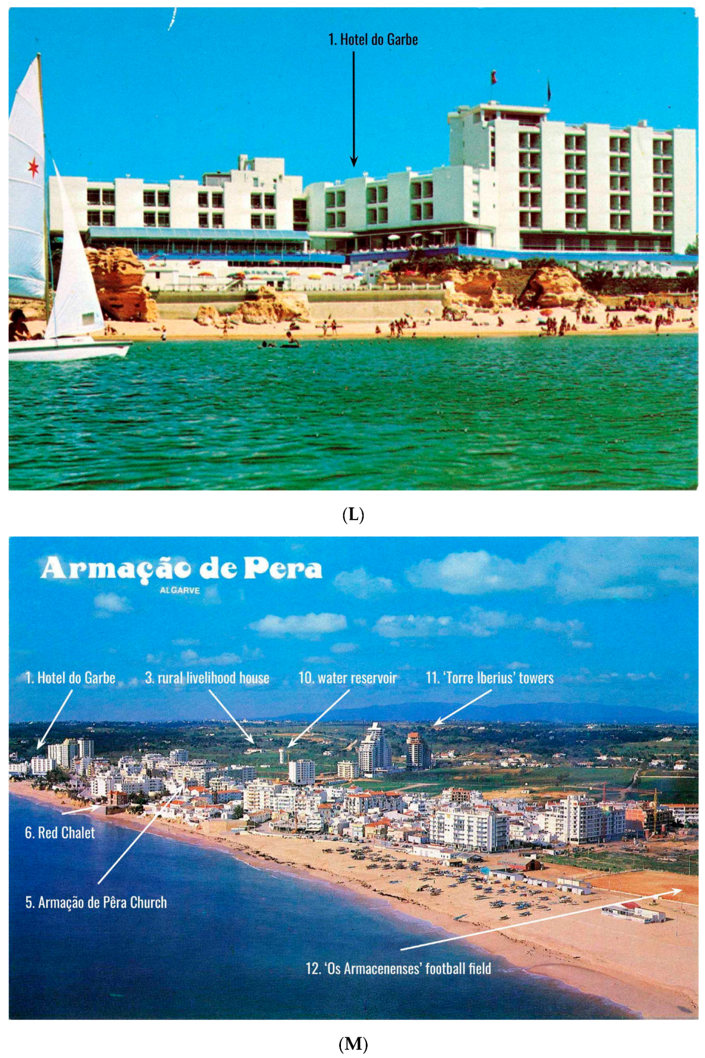
Armação de Pêra is located on the south coast of mainland Portugal (Figure 1). The village belongs to the Municipality of Silves, and the urban agglomeration was of recent construction, as the previous one was totally destroyed by the earthquake and tsunami of 1 November 1755 [27]. In the second half of the 19th century, it was a fishing village with around 1000 inhabitants and 250 houses, and during summer, the population doubled as a result of the demand for beach and sea bathing [28]. Qualities for sun and sea bathing continued to be recognized, and Armação de Pêra was mentioned in the short list of amazing beaches in Algarve, published in 1918 by Propaganda Society of Portugal [29]. A few years later, in 1923, the Initiative and Tourism Commission of Armação de Pêra was created, one of the first in the country. A tourist guide of Portugal described Armação de Pêra as one of the most frequented beaches by Algarvians [30]. On 20 July 1958, the local casino was opened to the public, bringing many foreigners to the village.

2.2. Hotel do Garbe

Hotel do Garbe began to be designed in 1959 by Portuguese architects Jorge R. Ferreira Chaves and Frederico Sant’Ana, benefiting from a privileged location on the edge of a coastal cliff near Armação de Pêra [31]. Inaugurated in 1963, the same year of the first “Plan of Touristic Valorisation of the Algarve”, Hotel do Garbe quickly became a reference in the new national architecture and an example for the opening to the international sun- and sea-bathing tourism that respected the environment and the cultural authenticity of the region [32]. Wright and Swift, in their book Algarve, a portrait and a guide, mentioned it as “the most elegant modern hotel on the coast” [33] (p. 271).
The national authorities, while authorizing and applauding the construction of the hotel, expressed their concerns about the potential harm caused by the mass tourism that was probably starting to invade the region [34]. The effective threat only began two years later, in 1965, with the opening of Faro Airport [35]. The new gateway to Algarve and the internationalization of the tourist industry in the region were enough to impose deep changes in the south coastal strip, especially in those parts that ensured an easy access to the until then unspoiled beaches with “golden, fine sandy beaches and warm, transparent sea waters”.
The Hotel do Garbe initial project only had 30 rooms, but at the time of its opening, the capacity had already been doubled. Between the 1960s and the present, the hotel underwent several expansions. The most relevant ones took place in the 1970s, 1980s and 2000s, and the number of rooms step-by-step increased to 100, 140 and 184. In this gradual increase in accommodation capacity, the construction of a 13-floor tower with 110 rooms did not materialize, as it was not licensed by the national authorities. A reading of the vast technical documentation on the construction and expansion of Hotel do Garbe, filed at the Municipality of Silves Archive, makes it possible to know that other architects, such as Cândido P. Teixeira de Melo, António L.C. Cortez de Lobão and Margarida M. Simões Gomes, participated. In the justifications for the initial construction and the 1970s expansion, enormous concern about the landscape integration of the building is noticeable, avoiding confronting the natural beauty of the place. From the 1980s onwards, the concern changed, and the goal began to be to always obtain authorization for the greatest possible number of rooms, which is only possible with high-rise construction.
Since the opening, the hotel has received three commercial names. In the beginning, it was Hotel do Garbe, but soon the name was simplified to Hotel Garbe. In 2010, it was changed to Holiday Inn Algarve, the present name. Here, we keep the original name to simplify the narrative.

2.3. Study Area

The study area was a circle with a radius of 2 km, whose center was the geographical position of Hotel do Garbe (37.10225° N 8.36660° W). It is a portion of land large enough, even at present, to encompass the entire village of Armação de Pêra. The effective area is only 7.59 km2, because part of the circle coincides with the Atlantic Ocean.

2.4. Data Sources

2.4.1. Photographs and Architectural Drawings

Orthorectified Vertical Aerial Photographs

Four orthorectified vertical aerial photographs were used. They covered a period of 60 years, separated by regular intervals of about 20 years: 1958, 1978, 1997 and 2018. The 1958 photograph was provided in digital format by CIGeoE (Army Geospatial Information Center), and it was orthorectified and georeferenced by us. The remaining photographs are available online using Web Map Service from CCDRAlg (Coordination Commission of the Algarve Region) and DGTerritório (General Directorate of the Territory). Figure 2A–D show excerpts from these four vertical aerial photographs.

Picture Postcards

Armação de Pêra was and remains a preferred tourist destination in Algarve, and Hotel do Garbe is an iconic building. There are, therefore, a large number of picture postcards, mainly from the 1960s to the 1980s, where it is possible to see the hotel and the village in detail. Within the framework of this study, two private collections were searched: that of the author and that of another collector. Preference was given to circulated postcards, as stamps helped confirm the dating of the photograph, and we gave preference to postcards with aerial panoramic images or postcards documenting places such as the beach and other surrounding public spaces. Fourteen picture postcards were chosen to be part of this article. The main criteria adopted for their selection were (i) the usefulness of providing information that was not readable in the vertical aerial photographs; (ii) the contribution to the time-series construction, with photographs from different decades; (iii) the diversity of the points of view, with oblique aerial photographs and photographs taken at the ground level.
After choosing the postcards, twelve buildings and public infrastructures with special visibility in the landscape were chosen to help in the narrative of the evolution of the study area during the six decades. They could be easily identified both in the vertical aerial photographs and in the picture postcards and were numbered from 1 to 12. Figure 3 presents the geographical positions of the twelve buildings and public infrastructures. The correspondence between the numbers in Figure 3 and the designation of buildings and public infrastructures can be performed using the captions marked on the picture postcards themselves. Figure 4A–N present the fourteen picture postcards.

Architectural Drawings and Models of Hotel do Garbe

Two architectural drawings and a photograph of one model particularly relevant to illustrate the narrative of the evolution of Hotel do Garbe were selected from the vast documentation on the construction and expansion of the building filed at the Municipality of Silves Archive (Figure 5A–C).

Actual Oblique Aerial Photographs Taken with a Drone

An oblique aerial photograph taken with a drone (DJI Phantom 4 Pro V2.0) in February 2022 trying to replicate the photographic framing of one of the aforementioned picture postcards (Figure 4B) was also added to the set of photographs used in this article. Some of the buildings and public infrastructures with special visibility in the landscape can also be identified in this photograph.

2.4.2. Maps

Topographic Maps

The study area is represented in Portuguese Military Map—Sheet 604, prepared and published by CiGeoE at a scale of 1:25,000. There are three editions: the first one was published in 1955; the second one, in 1979; and the third one, in 2005.

Land-Cover and Land-Use (LCLU) Catalog and Maps

Using the capabilities of QGIS 3, an open source Geographic Information System, four LCLU maps restricted using two main themes (artificialized areas and road transport network) were produced for the study area. Previously, a specific catalog of fourteen LCLU classes was established (Table 1), based on European CORINE Land Cover and the Portuguese official LCLU nomenclatures.

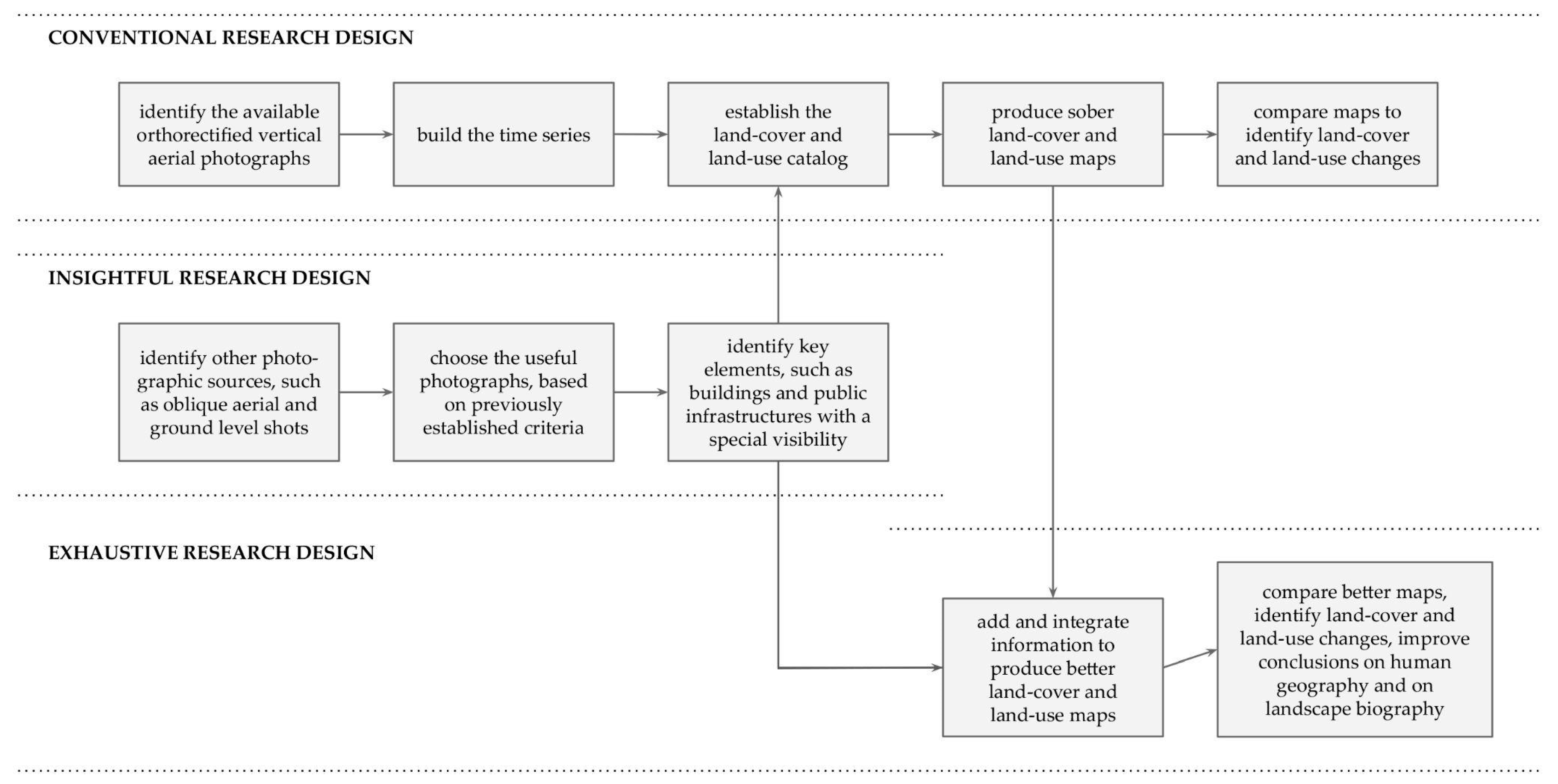
2.5. Research Design

Figure 6 summarizes the research design that was established for this study, which is recommended to be adopted in similar studies. The figure differentiates the conventional research design, which uses maps made based on the interpretation of orthorectified vertical aerial photographs, here denominated as sober land-cover and land-use maps, from the insightful research design, which produces better land-cover and land-use maps resulting from the addition of information coming from other photographic sources. The exhaustive research design, that is, the fusion of the conventional and insightful designs, gives the opportunity to have better maps and to deepen analysis and conclusions on human geography and landscape biography.

3. Results

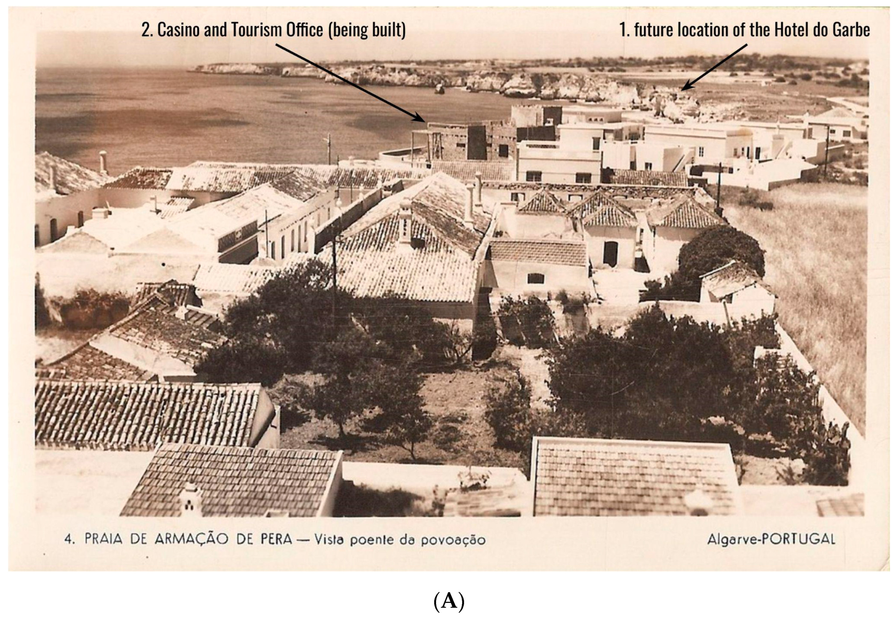
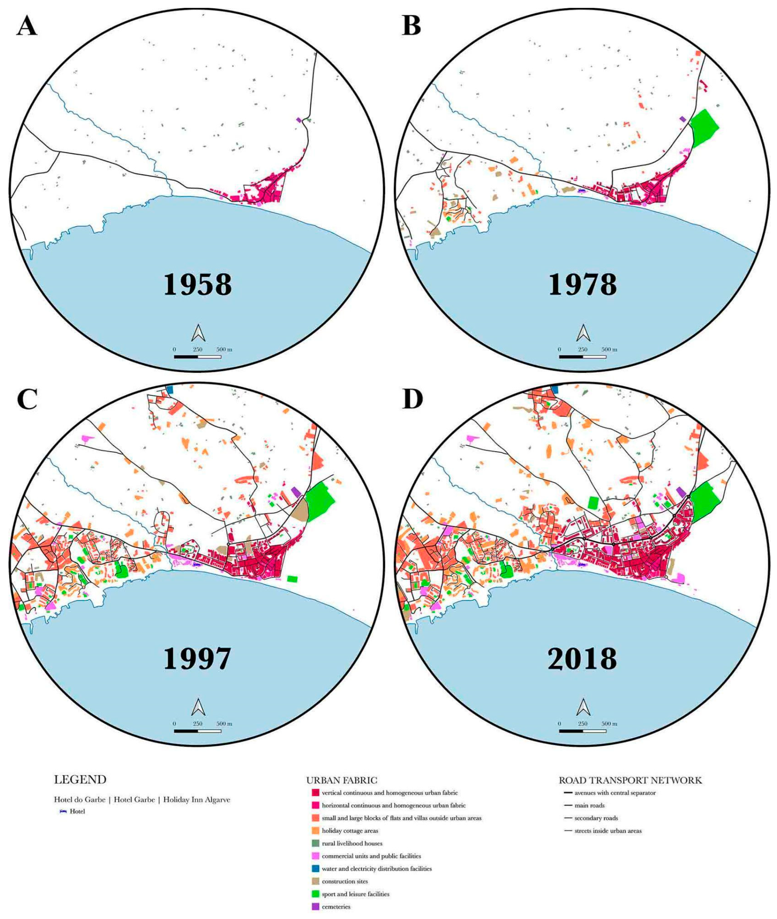
3.1. Time Step 1: 1958

Following the research design proposed and already summarized in Figure 6, the characterization of LCLU in 1958, when Hotel do Garbe had not yet been built, is presented in Figure 7A. The map was mainly based on the orthorectified aerial vertical photograph (excerpt in Figure 2A), and the 1955 topographic map was useful to validate photo interpretation. A 1950s picture postcard (Figure 4A) showing part of the Armação de Pêra village and the casino being built was the indicator used to classify the entire urban area as “horizontal continuous and homogeneous urban fabric”. Several 1960s picture postcards, such as the ones presented here (Figure 4B–E), illustrate the rural landscape surrounding Hotel do Garbe and the traditional urban pattern of Armação de Pêra. At that time, there were only buildings and public infrastructures with special visibility in the landscape numbers 2, 3, 5 and 6 (Figure 3).

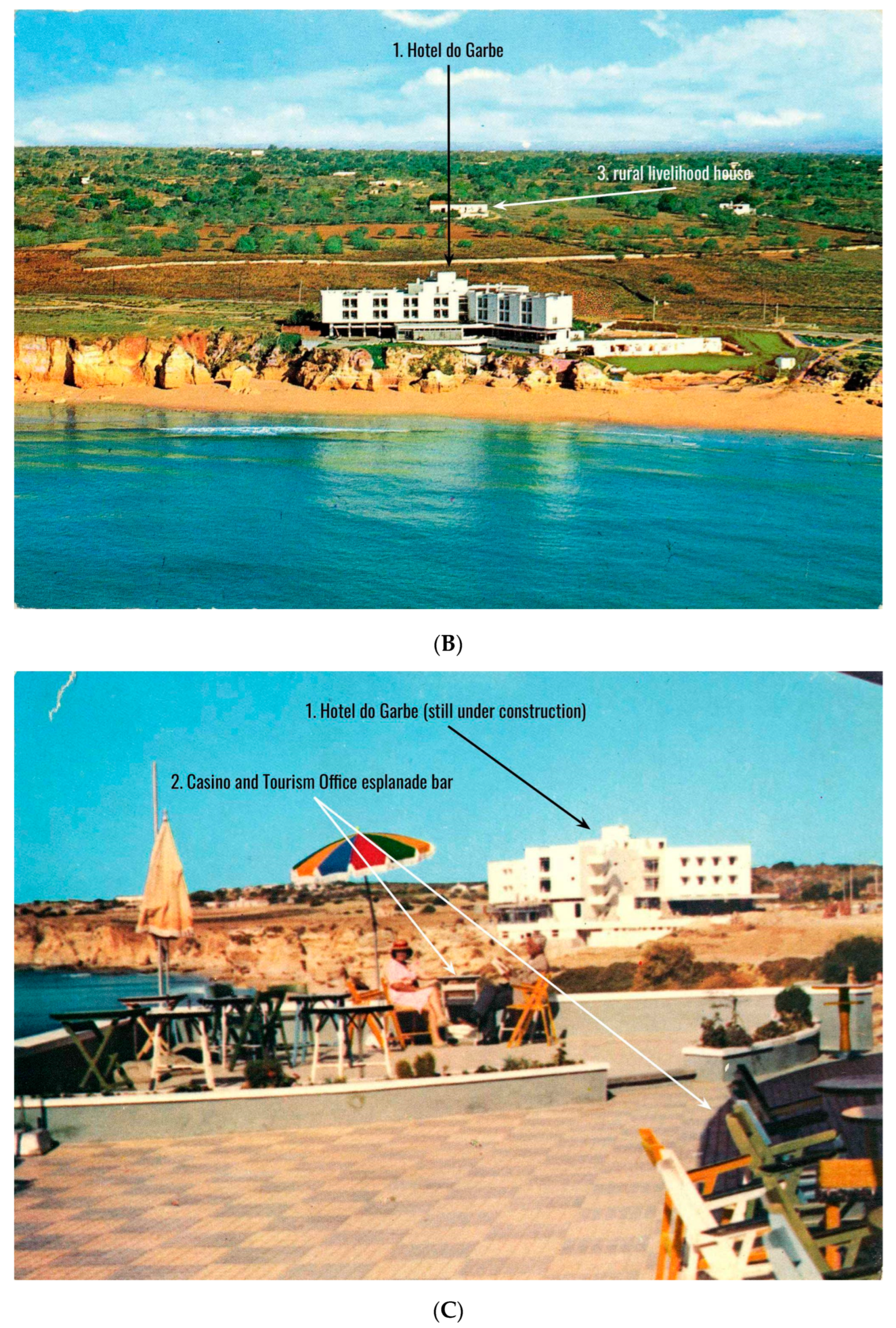
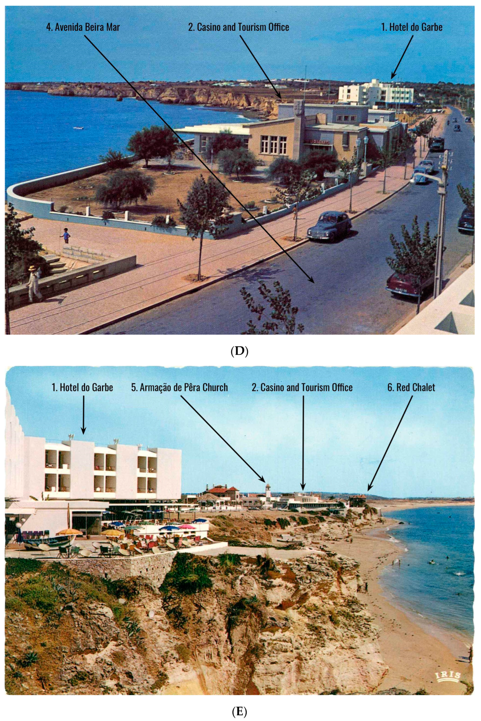
3.2. Time Step 2: 1978

LCLU in 1978 are presented in Figure 7B. The orthorectified aerial vertical photograph (excerpt in Figure 2B) was the privileged conventional source of information, and photo interpretation was validated by consulting the 1979 topographic map. Picture postcards, such as the ones presented here (Figure 4I,J), were useful to classify the urban area as “vertical” or “horizontal continuous and homogeneous urban fabric”. The architectural model and the drawings from the 1970s and 1980s illustrate Hotel do Garbe in different moments (Figure 5A,C), including the one never materialized due to the missed licensing of the project (Figure 5B). Only building with special visibility in the landscape number 10 did not yet exist at that time.

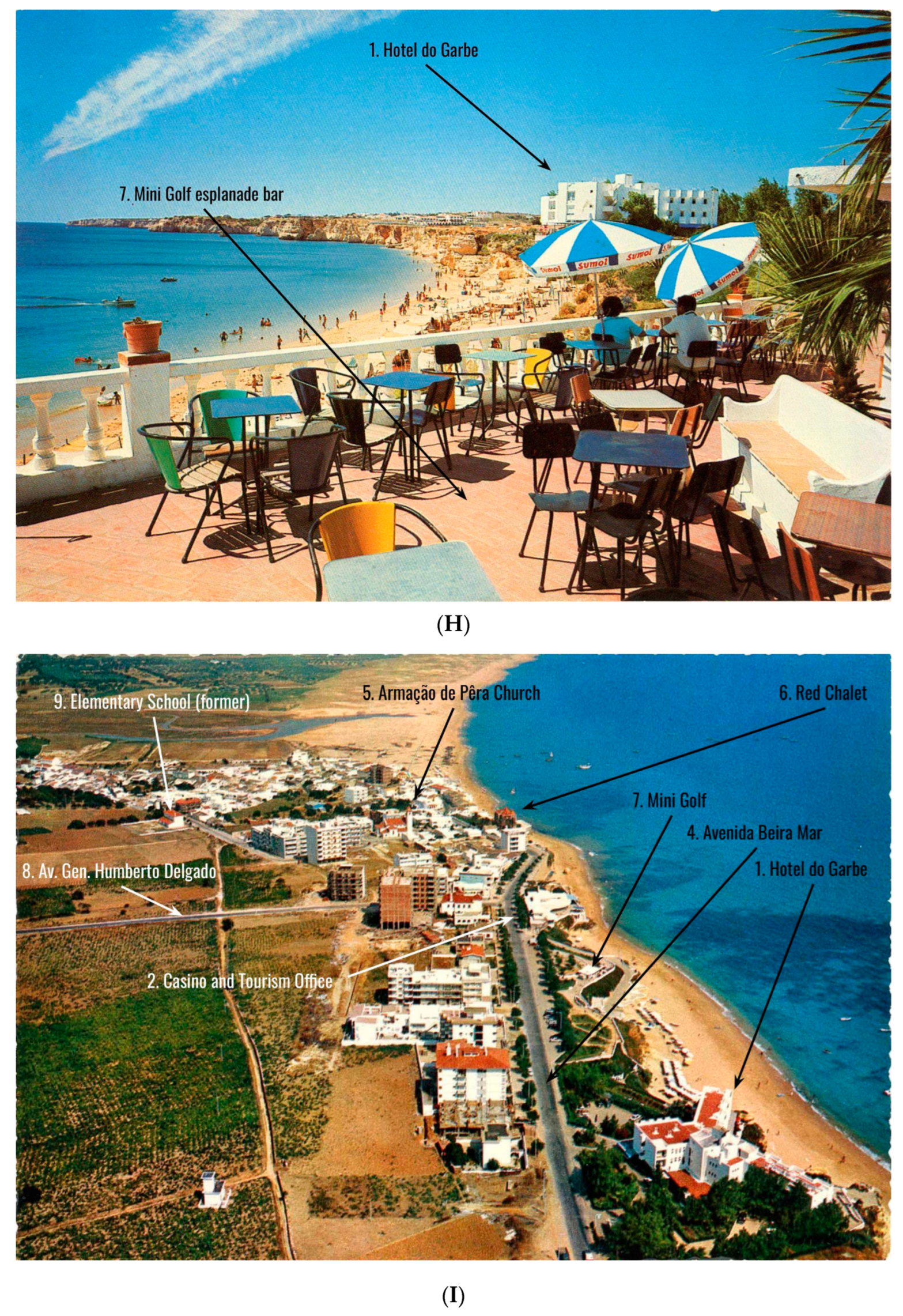
3.3. Time Step 3: 1997

LCLU in 1997 are presented in Figure 7C. The main source of information was similar to those used in the previous maps. It is the first orthorectified vertical aerial photograph in natural color (excerpt in Figure 2C), as the previous ones were in black and white. Two detailed oblique aerial photographs taken in the late 1990s or early 2000s [36] were equally decisive in distinguishing between “vertical” or “horizontal continuous and homogeneous urban fabric”. Photo interpretation was also validated using the 2005 topographic map and some picture postcards (such as Figure 4J,M). All twelve buildings and public infrastructures with special visibility in the landscape were already present.

3.4. Time Step 4: 2018

Finally, LCLU in 2018 are presented in Figure 7D. The orthorectified aerial vertical photograph (excerpt in Figure 2D) was the privileged source of information. Google Earth, Google Maps and field visits validated photo interpretation. In recent decades, scenic picture postcards have almost disappeared, as they have been replaced by other forms of communication. Even so, there are still some, such as the one (Figure 4N) that shows the actual Hotel do Garbe, which also indicates that it continues to be a symbol of Armação de Pêra. Building with special visibility in the landscape number 3 had already been demolished and replaced with more recent and larger constructions. Likewise, public infrastructure number 12 was transferred to a new location, north of Armação de Pêra.

3.5. Time Series: 1958 to 2018

Table 2 describes the LCLU areas and road network lengths related to the four years studied (1958, 1978, 1997 and 2018), and LCLUCs between 1958 and 2018. A simple and very insightful quantitative metric was selected to compute these changes, as increases were measured by dividing the values for a date by the ones for the immediately preceding date.
A case study of six decades of LCLUCs in a village/tourist city and their surrounding area, which is brightened by the presence of one of the historic and iconic Algarve hotels, is presented in this article. To carry out the analysis, a research design was established, and it is also presented here. Attention was paid to anthropic land artificialization (urban fabric + road transport network), and the recent history of this stretch of the southern coast of mainland Portugal can be glimpsed in the sequence of the four LCLU maps (Figure 7A–D). In 1958, Armação de Pêra was a small fishing village, and inland, the study area was intensively cultivated (Figure 4A,B), with numerous spread-out rural livelihood houses (Figure 7A). The proportion was 77% of housing construction located in the village of Armação de Pêra (Table 2, classes 1.1.1 + 1.1.2) and 23% of housing construction located outside the urban agglomeration (Table 2, class 1.2.3). In 1960, 1947 people lived in Armação de Pêra [37].
The year 1978 roughly coincided with the beginning of the true boom in the tourism and building industries, after the tenuous effects that resulted from the Faro Airport opening in 1965 and the consequent growth in the number of foreigners looking for “golden, fine sandy beaches and warm, transparent sea waters”. In the meantime, Portugal was in turmoil with the freedom that had been inspired by the carnation revolution on 25 April 1974. The impact of high-rise housing construction in Armação de Pêra, which began to expand, the installation of the campsite in the east and the scattered buildings, such as hotels, villas and second-home houses, in the west are examples of the transformation that was taking place (Figure 7B). Proportions also started to change, as the previous 77% of the village of Armação de Pêra decreased to 57% and the 23% of rural livelihood houses decreased to 7%; further, 30% of another type of scattered buildings emerged (Table 2, classes 1.1.1 + 1.1.2; class 1.2.3; classes 1.2.1 + 1.2.2). Overall, the sealed area tripled between 1958 and 1978 (Table 2, urban fabric increase), but in contrast, the resident population only increased to 2680 people by 1981 [38].
The consequences of LCLUCs were already very evident in 1997 (Figure 7C). In that year, the village represented only 30%, and rural livelihood houses represented 5%; the other scattered buildings reached 65% (Table 2, classes 1.1.1 + 1.1.2; class 1.2.3; classes 1.2.1 + 1.2.2). Overall, the sealed area once again tripled in comparison to 1978 (Table 2, urban fabric increase), but once again the resident population only increased to 3770 people by 2001 [39]. It is a growth of only 1.4 times, much lower than that observed in the sealed area. Land near the coastline was almost completely occupied with housing constructions and roads, and wild stretches became residual. An exception remains at the eastern end of the study area, which was not intervened upon, as it is wetland (Lagoa dos Salgados). Though not evidenced by the above numbers, national concern about coastal planning and the mitigation of the established disorder was greatly accentuated throughout the 1990s. The legislation that was approved imposed restrictions on uncontrolled construction, and the authorities heavily invested in infrastructures, such as the road transport network and basic sanitation. Portugal joined the European Union on January 1, 1986, a historical opportunity for supporting many of these public investments. One of the measurable effects was the growth of the road transport network, which increased by more than 2.6 times between 1978 and 1997 (Table 2, road transport network increase). In the two previous decades, the growth had been lower, of only 1.8 times.
The year 2018, when compared with 1997, denoted slight differences in the proportions of continuous and homogeneous urban fabric; rural livelihood houses; and scattered recent buildings, such as hotels, villas and second-home houses. Even so, it is possible to verify that new construction was taking place inland, largely because the coast no longer had available land plots. A new pattern of LCLU appeared to have consolidated, and the increases in urban fabric and road transport network were very similar, around 1.4 times, between 1997 and 2018, which is a smaller value than that of the previous analyzed intervals (Table 2, urban fabric and road transport network increases). The new LCLU pattern was much more complex than the one in 1958, which consisted of the village agglomeration and the numerous scattered rural houses. Progressively, two new classes emerged, “small and large blocks of flats and villas” and “holiday cottage areas”, typologies that correspond to owners with medium or medium-high economic power and to owners with high-to-very-high economic power. Hotels, due to their characteristics, are also included in the “small and large blocks of flats and villas” class. Armação de Pêra has always been socio-economically plural, offering the campsite as a holiday stay for many families with lower economic resources. The resident population increased to 6003 people by 2021 [40], which means a growth of 1.6 times compared with 2001.
It is necessary to bear in mind that comparisons between the growth of the resident population and that of the sealed area are biased. To ensure higher accuracy, it would be crucial to count the real area, resulting from the number of floors of each building, an exercise that was not carried out due to lack of detailed information. After making these calculations, the contrast between the growth rate of the resident population and the growth rate of the sealed area would be much more significant.
In just six decades, in the study area, the sealed land multiplied 12 times, going from 1.5% to 18%. In the same period, the resident population growth was much lower, making it evident that the increase in the built-up area was not intended to accommodate it. Hotel do Garbe, nowadays Holiday Inn Algarve, an internationally sounding name, has also grown, albeit more modestly. Since its opening in 1963, its number of rooms has tripled. The increase would have been more significant, bigger than four times, if the authorities had not rejected an expansion project submitted in the 1980s. Moreover, it would have been even higher, more than six times, if the original number of rooms (30) had been adopted as the statistical basis instead of the one existing at the time of opening (60 rooms). Obviously, the number of available rooms in hotels located in Armação de Pêra grew much more than those in Hotel do Garbe, because in these six decades, several units in the village and its surroundings opened to satisfy the tourist demand.
As elements fundamental to carrying out the exhaustive research design, picture postcards, with their two faces, were useful to understand the profound transformation of a fishing village, which, in a few decades, became a tourist city. Some of the picture postcards presented in this article show, on their front face, the beach; terraces overlooking the sea; many people enjoying the sun, sand and sea; and the pleasure of being on holiday in Armação de Pêra. These “photographs of places” displaying sunny terraces with their colorful umbrellas (Figure 4C,E,F,H,K) or the beach (Figure 4G,K,L,N), where in the 2000s, water amusement equipment gained refinement, are a huge strength to accurately write a chapter on the landscape biography of Hotel do Garbe and Armação de Pêra. The brief messages written on the postcard back faces corroborate the offer of goods and services focused on leisure; happy days are always reported, and the only complaint that sometimes arises is the hot weather that catches by surprise tourists directly coming from cooler climates. Other picture postcards, such as Figure 4B,I,J,M, are true “landscape photographs” with a “bird’s eye” point of view. Armação de Pêra, as a village and then a tourist city, can be seen as a whole, and another chapter on the same landscape biography, but on a different geographical scale, can be written.
Finally, a 1960s picture postcard (Figure 4B) and an actual oblique aerial photograph (Figure 8) taken with a drone share almost the same point of view and allow a better understanding of the symbolism of Hotel do Garbe and of the dream that has been transformed into truth to be grasped. Of course, we think and talk about the dream that was to transform the small fishing village of Armação de Pêra into a medium sized tourist city.

4. Discussion and Conclusions

To evaluate the use of photography to make better LCLU maps was one of the aims of this study. The other one was to highlight the advantages of integrating photographs from several sources, complementary among themselves, to provide richer knowledge of places and landscapes. Orthorectified vertical aerial photography offers a systematic and geometric adherent representation of the territory, and it is one of the conventional privileged bases for the production of thematic cartography. However, there are some limitations, with complex solutions, that cannot be ignored when the target is a large-scale LCLU map with a detailed legend. For instance, when determining the height of buildings, or the volumes of buildings and the ground-level spaces between them, because photographic distortions, apparent displacements and occlusions or shadows prevent the accurate interpretation of misrepresented areas [41,42,43,44,45]. Figure 2A–D show excerpts from the four aerial photographs that were used and support the foregoing considerations. It is evident that the most recent aerial photographs (1979 and 2018) are more informative and clarifying than the older ones (1958 and 1978), as they are color images and have higher resolution. However, it would have been difficult to achieve the accurate results illustrated in the LCLU maps if there had not been the parallel consultation of other photographic sources. Resolution is a permanent constraint of orthorectified vertical aerial photographs that can be partially overcome with the use of stereoscopic pairs, but which becomes severe when the thematic maps to be prepared must have a large scale and high accuracy.
The most valuable finding of this study comes from the use of picture postcards, especially those that feature oblique aerial photographs, and its most innovative facet results from the balance of all the photographic sources consulted. It is an approach quite different from the practices of “Mission photographique de la DATAR” and its replicas, or “The Rephotographic Survey Project” and “Third Views”, who valued photographs taken at the ground level and ignored aerial photography. Oblique aerial photographs provide information of enormous relevance, not only for thematic map preparation but also for understanding places and landscapes. Picture postcards, which are often undervalued or forgotten, because they are images intended for the tourist market and thus are full of emotions, are, after all, photographic documents that also provide elements of interest for human geography and landscape research. These images are a valuable contribution to the biography of Armação de Pêra and suggest that other but similar ones may be useful to do the same in different places or landscapes. The photographers responsible for these images were at the service of human geography and landscape biography and can be considered “involuntary or accidental photo-geographers”. The photo-documents they have produced over the years are numerous, even in a country such as Portugal, where “photography of place” and “landscape photography” have no tradition. Algarve, possibly because it is a touristic region, has a collection of postcards with oblique aerial photographs that deserves to be more carefully studied, and this article is just a small step. The number of different photographs and the diversity of both points of view and dates ensure a plurality of information that can even mitigate the eventual bias of the images towards the positive emotions that have captivated tourists for decades.
In the recent past and at present, it is certain that picture postcards have almost disappeared. However, they have been replaced by profusely illustrated tourist albums, and the popularization of drones has brought a new inspirational breeze and a new opportunity for oblique aerial imagery with great informative value. Therefore, we suggest that in studies similar to this one, adequate effort be made to find and bring together these surprising photographic sources of data.

Funding

This research received no external funding.

Institutional Review Board Statement

Not applicable.

Informed Consent Statement

Not applicable.

Data Availability Statement

A wider set of reproductions of picture postcards, with “photographs of places” and “landscape photographs” of Hotel do Garbe and Armação de Pêra can be found on https://www.nsloureiro.pt/estudios-tavares-fonseca/armação-de-pêra (accessed on 5 March 2023).

Acknowledgments

The author would like to thank Nelson Fantasia, the collector who allowed the author to consult his picture postcard collection and lent some to be used in this article; Rui Nobre and Maria Eulina Pinheiro Ribeiro from the Municipality of Silves Archive, for the authorization to consult the historical documentation related to Hotel do Garbe; and CIGeoE (Army Geospatial Information Center), which provided the 1958 vertical aerial photograph. The author would also like to thank landscape architect Paula Farrajota, for the encouragement to carry out this study, and Bruno Filipe Pires, for some suggestions during the initial phase of the investigation.

Conflicts of Interest

The author declares no conflict of interest.

References

  1. Méaux, D. Geo-Photographers. Photographies 2019, 12, 209–226. [Google Scholar] [CrossRef]
  2. Rose, G. Using Photographs as Illustrations in Human Geography. J. Geogr. High. Educ. 2008, 32, 151–160. [Google Scholar] [CrossRef]
  3. Telles, G.R. Para Além da Revolução; Edições Salamandra: Lisboa, Portugal, 1985. [Google Scholar]
  4. Daniels, S.; Cosgrove, D. Introduction: Iconography and landscape. In The Iconography of Landscape: Essays on the Symbolic Representation, Design and Use of Past Environments; Cosgrove, D., Daniels, S., Eds.; Cambridge University Press: New York, NY, USA, 1988; p. 1. [Google Scholar]
  5. Council of Europe. The European Landscape Convention, Signed at Florence on 20 October 2000; ELC Article 1–Definitions; Council of Europe: Strasbourg, France, 2000; Available online: https://rm.coe.int/16807b6bc7 (accessed on 18 November 2021).
  6. Canary Islands Manifesto for the European Landscape Project. Manifiesto de Canarias por el Proyecto de Paisaje Europeo; Observatorio del Paisaje de Canarias: Santa Cruz de Tenerife, Spain, 2011. [Google Scholar]
  7. Antrop, M.; van Eetvelde, V. Landscape as a holistic, perceptive and dynamic phenomenon. In Landscape as a Project; Pedroli, B., Goodman, T., Eds.; Casa Editrice Libria: Melfi, Italy, 2010; pp. 40–45. [Google Scholar]
  8. Samuels, M.S. The Biography of Landscape. Cause and Culpability. In The Interpretation of Ordinary Landscapes. Geographical Essays; Meinig, D.W., Ed.; Oxford University Press: New York, NY, USA, 1979; pp. 51–88. [Google Scholar]
  9. Spicer, E.A.; Swaffield, S.; Moore, K. A landscape and landscape biography approach to assessing the consequences of an environmental policy implementation. Landsc. Res. 2020, 45, 444–457. [Google Scholar] [CrossRef]
  10. Carrabine, E. Geographies of landscape: Representation, power and meaning. Theor. Criminol. 2018, 22, 445–467. [Google Scholar] [CrossRef]
  11. Castel, R. Images et Phantasmes. In Un Art Moyen. Essai Sur Les Usages Sociaux de la Photographie, 2nd ed.; Bourdieu, P., Boltanski, L., Castel, R., Chamboredon, J.-C., Eds.; Les Éditions de Minuit: Paris, France, 1965; p. 294. [Google Scholar]
  12. Marques, S.L. Ether/Vale Tudo Menos Tirar Olhos (1982–1994). Um Laboratório de Fotografia e História; Dafne Editora: Porto, Portugal, 2018; p. 31. [Google Scholar]
  13. Godfrey, A.C. Active Landscape Photography. Theoretical Groundwork for Landscape Architecture; Routledge: Oxford, UK, 2020; p. 63. [Google Scholar]
  14. Sevenant, M.; Antrop, M. Landscape Representation Validity: A Comparison between On-site Observations and Photographs with Different Angles of View. Landsc. Res. 2011, 36, 363–385. [Google Scholar] [CrossRef]
  15. Hers, F.; Latarjet, B. L’Expérience du Paysage. In Paysages Photographies. La Mission Photographique de la DATAR. Travaux en Cours 1984/1985; DATAR—Délégation à l’Aménagement du Territoire et à l’Action Régionale, Ministère du Plan et de l’Aménagement du Territoire; Editions Hazan: Vanves, France, 1985; pp. 353–445. [Google Scholar]
  16. Kumar, N. Repetition and Remembrance: The Rephotographic Survey Project. Hist. Photogr. 2014, 38, 137–160. [Google Scholar] [CrossRef]
  17. Mocquet, F. L’Observatoire photographique national du paysage: Archive rétrospective et prospective des territoires. Livraisons De L’histoire De L’architecture 2016, 31, 1–17. [Google Scholar] [CrossRef] [Green Version]
  18. Campbell, J.B. Mapping the Land: Aerial Imagery for Land Use Information; Resource Publications in Geography; Association of American Geographers: Washington, DC, USA, 1983. [Google Scholar]
  19. Foltête, J.-C.; Litot, J.-B. Scenic postcards as objects for spatial analysis of tourist regions. Tour. Manag. 2015, 49, 17–28. [Google Scholar] [CrossRef]
  20. Pritchard, A.; Morgan, N. Mythic Geographies of Representation and Identity: Contemporary Postcards of Wales. J. Tour. Cult. Change 2003, 1, 111–130. [Google Scholar] [CrossRef]
  21. Chevrier, J.-P. La Photographie dans la Culture du Paysage. In Paysages Photographies. La Mission Photographique de la DATAR. Travaux en Cours 1984/1985; DATAR—Délégation à l’Aménagement du Territoire et à l’Action Régionale, Ministère du Plan et de l’Aménagement du Territoire; Editions Hazan: Vanves, France, 1985; pp. 380–381. [Google Scholar]
  22. Debussche, M.; Lepart, J.; Dervieux, A. Mediterranean landscape changes: Evidence from old postcards. Glob. Ecol. Biogeogr. 1999, 8, 3–15. [Google Scholar] [CrossRef]
  23. Paxion, K.; Cohen, O. La baie de Wissant: Cent ans d’évolution en images. Mappemonde 2002, 67, 24–27. [Google Scholar] [CrossRef]
  24. Sawyer, C.F.; Butler, D.R. The Use of Historical Picture Postcards as Photographic Sources for Examining Environmental Change: Promises and Problems. Geocarto Int. 2006, 21, 73–80. [Google Scholar] [CrossRef]
  25. Domingues, Á. Volta a Portugal; Contraponto: Lisboa, Portugal, 2017. [Google Scholar]
  26. Mullins, P. Tourism Urbanization. Int. J. Urban Reg. Res. 1991, 15, 326–342. [Google Scholar] [CrossRef]
  27. Lopes, J.B.S. Corografia ou Memoria Economica, Estadistica, e Topografica do Reino do Algarve; Academia Real das Sciencias de Lisboa: Lisboa, Portugal, 1841; p. 290. [Google Scholar]
  28. Leal, A.S.A.B.P. Portugal Antigo e Moderno. Diccionario Geographico, Estatistico, Chorographico, Heraldico, Archeologico, Historico, Biografico e Etymologico de Todas as Cidades, Villas e Freguezias de Portugal; Livraria Editora de Mattos Moreira & Companhia: Lisboa, Portugal, 1873; Volume 1, pp. 238R–238S. [Google Scholar]
  29. Martins, P.A.G. Sea bathing and seaside tourism in Portugal in the nineteenth and twentieth centuries: An overview. J. Tour. Hist. 2015, 7, 246–267. [Google Scholar] [CrossRef]
  30. Biblioteca Nacional de Lisboa. Guia de Portugal—Volume 2: Estremadura, Alentejo, Algarve; facsimile of the first edition; Fundação Calouste Gulbenkian: Lisboa, Portugal, 1927; p. 262. [Google Scholar]
  31. Lobo, S.L.M. Arquitectura e Turismo: Planos e Projectos. As Cenografias do Lazer na Costa Portuguesa, da 1.ª República à Democracia. Parte III—O Avião e o Turista: Sun, Sand, Sea & Bikini. Ph.D. Thesis, Universidade de Coimbra, Coimbra, Portugal, 2013. Available online: http://hdl.handle.net/10316/23799 (accessed on 9 December 2021).
  32. Agarez, R. Regional identity for the leisure of travelers: Early tourism infrastructure in the Algarve (Portugal), 1940–1965. J. Archit. 2013, 18, 721–743. [Google Scholar] [CrossRef] [Green Version]
  33. Wright, D.; Swift, P. Algarve, a Portrait and a Guide; Barrie and Rockliff (Barrie Books Ltd.): London, UK, 1965. [Google Scholar]
  34. Paula, R.M. Hotel do Garbe. Arquitectura 1964, 83, 100–110. [Google Scholar]
  35. Mendes, A.C. O aeroporto de Faro como infraestrutura principal do desenvolvimento turístico da região. In Fragmentos para a História do Turismo no Algarve; Promontoria Monográfica, História do Algarve 2; CEPAC-FCHS-UAlg, Ed.; Universidade do Algarve: Faro, Portugal, 2015; pp. 261–264. [Google Scholar]
  36. Jorge, F.; Pessoa, F.S.; Bernardes, J.P.; Correia, J.E.H.; Costa, M.R.; Guerreiro, J.P. Algarve Visto do céu—The Algarve from the Sky; Argumentum: Lisboa, Portugal, 2005; pp. 128–129. [Google Scholar]
  37. INE—Instituto Nacional de Estatística. X Recenseamento Geral da População. Tomo I, Volume 2—Prédios e Fogos; População, com dados Retrospectivos (Lugares); INE: Lisboa, Portugal, 1964. [Google Scholar]
  38. INE—Instituto Nacional de Estatística. XII Recenseamento Geral da População. II Recenseamento Geral da Habitação. Resultados Definitivos—1981; INE: Lisboa, Portugal, 1983. [Google Scholar]
  39. INE—Instituto Nacional de Estatística. XIV Recenseamento Geral da População. IV Recenseamento Geral da Habitação. Resultados Definitivos—2001; INE: Lisboa, Portugal, 2002. [Google Scholar]
  40. INE—Instituto Nacional de Estatística. XVI Recenseamento Geral da População. VI Recenseamento Geral da Habitação. Resultados Definitivos—2021; INE: Lisboa, Portugal, 2022. [Google Scholar]
  41. Bonczak, B.; Kontokosta, C.E. Large-scale parametrization of 3D building morphology in complex urban landscapes using LiDAR and city administrative data. Comput. Environ. Urban Syst. 2019, 73, 126–142. [Google Scholar] [CrossRef]
  42. Hu, Y.; Stanley, D.; Xin, Y. True Ortho Generation of Urban Area using High Resolution Aerial Photos. ISPRS Ann. Photogramm. Remote Sens. Spat. Inf. Sci. 2016, 3, 2–10. [Google Scholar] [CrossRef] [Green Version]
  43. Morgan, J.L.; Gergel, S.E.; Coops, N.C. Aerial Photography: A Rapidly Evolving Tool for Ecological Management. BioScience 2010, 60, 47–59. [Google Scholar] [CrossRef]
  44. Van der Linden, S.; Okujeni, A.; Canters, F.; Degerickx, J.; Heiden, U.; Hostert, P.; Priem, F.; Somers, B.; Thiel, F. Imaging Spectroscopy of Urban Environments. Surv. Geophys. 2019, 40, 471–488. [Google Scholar] [CrossRef] [Green Version]
  45. Zhou, G.; Chen, W.; Kelmenis, J.A.; Zhang, D. A Comprehensive Study on Urban True Orthorectification. IEEE Trans. Geosci. Remote Sens. 2005, 43, 2138–2147. [Google Scholar] [CrossRef]
Figure 1. Geographical position of the village of Armação de Pêra, in the South Europe and North Africa region.
Land 12 00674 g001
Figure 2. (A) Excerpt from the 1958 orthorectified vertical aerial photograph, one of the privileged sources of information for the 1958 LCLU map. (B) Excerpt from the 1978 orthorectified vertical aerial photograph, one of the privileged sources of information for the 1978 LCLU map. (C) Excerpt from the 1997 orthorectified vertical aerial photograph, one of the privileged sources of information for the 1997 LCLU map. (D) Excerpt from the 2018 orthorectified vertical aerial photograph, one of the privileged sources of information for the 2018 LCLU map.
Land 12 00674 g002
Figure 3. Geographic position of the twelve buildings and public infrastructures with special visibility in the landscape inside the study area. Hotel do Garbe coincides with number 1. The background is the orthorectified vertical aerial photograph dated from 1958.
Land 12 00674 g003
Figure 4. (A) Picture postcard (1950s)—photo by J.A. Costa; uncirculated. Caption printed on the back of the picture postcard: “Armação de Pêra beach. West view of the village. Algarve-Portugal”. Notes: a. Casino and Tourism Office being built. b. The flat land behind the houses and close to the cliffs and the beach is where Hotel do Garbe was later built. (B) Picture postcard (1960s)—photo by Almeida d’Eça; uncirculated. Caption printed on the back of the picture postcard: “Algarve. Armação de Pêra (Portugal). Hotel Garbe”. (C) Picture postcard (1960s)—uncirculated. Caption printed on the back of the picture postcard: “Armação de Pêra beach, Algarve (Portugal). Casino open-air bar and Hotel Garbe”. Notes: c. Hotel do Garbe under construction. (D) Picture postcard (1960s)—uncirculated. Caption printed on the back of the picture postcard: “Armação de Pêra, Algarve. Casino and Seaside Avenue (Avenida Beira Mar, in Portuguese)”. (E) Picture postcard (1960s)—circulated in August 1969. Caption printed on the back of the picture postcard: “Armação de Pêra. Hotel Garbe”. (F) Picture postcard (1960s or 1970s)—photo by Almeida d’Eça; uncirculated. Caption printed on the back of the picture postcard: “Armação de Pêra beach, Algarve”. (G) Picture postcard (1960s or 1970s)—uncirculated. Caption printed on the back of the picture postcard: “Armação de Pêra beach, Algarve”. (H) Picture postcard (1960s or 1970s)—photo by César de Sá; uncirculated. Caption printed on the back of the picture postcard: “Armação de Pêra. Algarve—Portugal”. (I) Picture postcard (1960s or 1970s)—circulated in May 1971. Caption printed on the back of the picture postcard: “Armação de Pêra, Algarve, Aerial View”. Notes: d. Photo by Estúdios Tavares da Fonseca [36], p. 128. (J) Picture postcard (between 1974 and 1976)—circulated in July 1976. Caption printed on the back of the picture postcard: “Armação de Pêra, Algarve”. Notes: e. The first relevant expansion, which took place in the first half of the 1970s and gave rise to the swimming pool and the eastern block with five floors of rooms, was already completed. (K) Picture postcard (between 1974 and 1976)—photo by Almeida d’Eça; circulated in June 1976. Caption printed on the back of the picture postcard: “Hotel Garbe. Armação de Pêra. Algarve—Portugal”. (L) Picture postcard (second half of the 1970s or 1980s)—uncirculated. Caption printed on the back of the picture postcard: “Armação de Pêra. Hotel Garbe”. (M) Picture postcard (1980s)—circulated in August 1986. Caption printed on the back of the picture postcard: “Armação de Pêra, aerial view”. (N) Picture postcard (second half of the 2000s)—photo by Michael Howard; circulated in November 2012. Caption printed on the back of the picture postcard: “Hotel do Garbe, Armação de Pêra, Algarve”.
Land 12 00674 g004aLand 12 00674 g004bLand 12 00674 g004cLand 12 00674 g004dLand 12 00674 g004eLand 12 00674 g004fLand 12 00674 g004gLand 12 00674 g004h
Figure 5. (A) Photograph of the architectural model included in the first relevant Hotel do Garbe expansion project, presented in the early 1970s by architect Jorge R. Ferreira Chaves. (B) Architectural drawing of a southern perspective included in the second relevant Hotel do Garbe expansion project, presented in the early 1980s by architect Cândido P. Teixeira de Melo. Notes: f. The west tower, with eleven floors of rooms, was never authorized and, consequently, was not built. (C) Architectural drawing of a southern perspective included in the second relevant Hotel Garbe expansion project, presented in the late 1980s by architect Cândido P. Teixeira de Melo.
Land 12 00674 g005
Figure 6. Schematic presentation of the research design.
Land 12 00674 g006
Figure 7. (AD) Urban fabric and road transport network land-cover and land-use (LCLU) in 1958, 1978, 1997 and 2018.
Land 12 00674 g007
Figure 8. “Where’s Hotel do Garbe|Holiday Inn Algarve?” Oblique aerial view (February 2022)—photo by Nuno de Santos Loureiro.
Land 12 00674 g008
Table 1. Land-cover and land-use classes.
  • URBAN FABRIC
    1.1.
    Continuous urban fabric
    1.1.1.
    Vertical continuous and homogeneous urban fabric
    1.1.2.
    Horizontal continuous and homogeneous urban fabric
    1.2.
    Discontinuous urban fabric
    1.2.1.
    Small and large blocks of flats and villas outside urban areas
    1.2.2.
    Holiday cottage areas (including the house, a private swimming pool and walled green spaces)
    1.2.3.
    Rural livelihood houses
    1.3.
    Commercial units and public facilities (schools, social welfare institutions and urban car parks)
    1.4.
    Water and electricity distribution facilities
    1.5.
    Construction sites
    1.6.
    Sport and leisure facilities (swimming pools, golf courses and camping sites)
    1.7.
    Cemeteries
2.
ROAD TRANSPORT NETWORK
2.1.
Avenues with central separator
2.2.
Main roads
2.3.
Secondary roads
2.4.
Streets inside urban areas
Table 2. Land-cover and land-use in 1958, 1978, 1997 and 2018 in the study area disaggregated according to the 14 LCLU classes and their increases in urban fabric occupation areas and road transport network lengths.
1958197819972018
1. URBAN FABRICtotal (m2)104,230318,953946,3061,319,984
 1.1.1. Vertical continuous and homogeneous urban fabric42,000165,326267,676
 1.1.2. Horizontal continuous and homogeneous urban fabric75,77465,69932,52731,796
 1.2.1. Small and large blocks of flats and villas outside urban areas28,648284,142418,207
 1.2.2. Holiday cottage areas (including the house, a private swimming pool and walled green spaces)30,155140,956255,534
 1.2.3. Rural livelihood houses23,09923,81626,61825,800
 1.3. Commercial units and public facilities (schools, social welfare institutions, and urban car parkings)338810,99554,89093,676
 1.4. Water and electricity distribution facilities12349714971
 1.5. Construction sites36,67682,18043,888
 1.6. Sport and leisure facilities (swimming pools, golf courses, camping sites)78,221148,035171,776
 1.7. cemeteries1969262066616661
increase (times) 3.062.971.39
2. ROAD TRANSPORT NETWORKtotal (m)776413,98435,81049,027
 2.1. Avenues with central separator2184
 2.2. Main roads5850720992786271
 2.3. Secondary roads2132730412,909
 2.4. Streets inside urban areas1914464319,22927,663
increase (times) 1.82.561.37
Disclaimer/Publisher’s Note: The statements, opinions and data contained in all publications are solely those of the individual author(s) and contributor(s) and not of MDPI and/or the editor(s). MDPI and/or the editor(s) disclaim responsibility for any injury to people or property resulting from any ideas, methods, instructions or products referred to in the content.

