Article

Spatial and Temporal Characteristics of Dust Storms and Aeolian Processes in the Southern Balkash Deserts in Kazakhstan, Central Asia

1
State Key Laboratory of Desert and Oasis Ecology, Key Laboratory of Ecological Safety and Sustainable Development in Arid Lands, Xinjiang Institute of Ecology and Geography Chinese Academy of Sciences, Urumqi 830011, China
2
CAS Research Centre for Ecology and Environment of Central Asia, Urumqi 830011, China
3
Faculty of Geography and Environmental Sciences, Al-Farabi Kazakh National University, Almaty 050040, Kazakhstan
4
University of Chinese Academy of Sciences, Beijing 100049, China
*
Author to whom correspondence should be addressed.
Land 2023, 12(3), 668; https://doi.org/10.3390/land12030668
Submission received: 7 February 2023 / Revised: 8 March 2023 / Accepted: 8 March 2023 / Published: 12 March 2023
(This article belongs to the Topic Natural Hazards and Disaster Risks Reduction)

Abstract

:
Sand and dust storms are hazardous to the environment and have a significant role in desertification. Under the influence of climate change and human activities, dust storms and aeolian processes have been common phenomena in the Southern Balkash deserts in Kazakhstan, Central Asia. However, knowledge gaps on spatial and temporal characteristics of dust storms and aeolian process in the Southern Balkash deserts still exist. Therefore, in present study, meteorological observations and numerous cartographic materials were used to identify the powerful sources with the highest frequency of dust storms and aeolian processes in the Southern Balkash deserts. The result showed that the Southern Balkash deserts were covered mainly by transverse parabolic sands (48%), dome dunes (24%), and transverse dome dunes (23%), where the aeolian processes occurred to a significant degree. Significant and strong degrees of aeolian processes occurred in most of the Southern Balkash deserts. The eastern part of the Taukum and the northern part of the Zhamankum and Karakum deserts were prone to aeolian processes to a substantial degree. The Moiynkum, Bestas, Saryesikatyrau, and Taukum deserts had the most frequent storms, occuring, on average, 17 to 43 days/per year. The occurrence of dust storms has been of a stable decreasing trend since the 1990s, except for 2008–2009. Aeolian dust in the Southern Balkash deserts flowed mainly from the western and southwestern to the eastern and northeastern. The results of the present study shed light on the temporal and spatial characteristics of dust storms and aeolian processes in the Southern Balkash deserts. This is of great importance in helping to monitor and predict dust storms and motion patterns of aeolian dust in this region.

1. Introduction

Central Asia, located in the northern hemisphere’s temperate desert belt, is covered mainly by drylands and is one of the most important sources of global aeolian dust and aerosol [1,2]. Sand and dust storms are becoming more common events in the arid and semi-arid regions of Central Asia, particularly around the desert zone, as global temperatures rise [3,4,5]. Deserts in Kazakhstan and Central Asia are characterized by a continental climate with long dry summers, strong winds, a scarcity of vegetation cover, a lack of moisture in the soil, relatively low air humidity, frequent waterlogging of the soil, and atmospheric droughts [6,7]. The strong winds can carry sand/dust and form dunes, mounds, and ridges, since winds can remove sand particles of different sizes and move them during deflation over long distances [8,9,10,11]. Desertification because of soil deflation has affected desert and semi-desert regions in Kazakhstan and Central Asia [12,13].
The vast “dust belt”, which is the primary permanent source of storms in Central Asia, extends from the west to the southern deserts: the Caspian Sea deserts, the Kyzylkum, Aralkum deserts (Aral Sea region), and Southern Balkash deserts [14]. Sandy and clayey deserts, with an area of about 30 million ha, are mostly spread in this zone [15]. Sandy deserts occupy about one-third of the entire desert zone. The largest include the Kyzylkum, the Karakum, the Aralkum, the Moiynkum, the Saryesikatyrau (Southern Balkash deserts), and the sands of the Caspian lowlands (Naryn deserts). The deserts arose tens of thousands of years ago on the site of former (ephemeral) rivers, playas, and saline lakes [16] and are located mainly in the lowlands [17,18]. They are often the primary and active sources of aeolian processes as sand and dust storms of high frequencies [19,20,21,22,23,24,25,26,27,28].
Many terminal lakes in arid Central Asia have turned into deserts as a result of climate change and human activity, including a new salt desert in the playa of the Ebinur Lake basin, the newly formed Aralkum desert in the Aral Sea basin, and the world’s earliest Aral-Sea-type disaster (Lop Nur) in the Tarim Basin [29,30,31]. Since the 1970s, a substantial decrease in the Ile river runoff has led to a reduction in the Balkash Lake’s water depth, which accelerated the desertification process and had devastating effects on the diverse flora and fauna that depend on it [32]. Sand and dust storms are one of the main signs and causes of desertification in this region. Degradation and desertification are pervasive in the Southern Balkash deserts at present [20,33]. They have occurred mainly because of anthropogenic activities such as irrigation and electric energy production, which results in changes in the level of the Balkash Lake. The regulation of water resources and irrigation has led to the reduction of groundwater level, increasing water mineralization, and intensive soil salinization, consequently causing the growth of solonchak desert areas and the drying of ponds, leading to the promotion of aeolian processes such as dust/salt storms [25] and plant changes toward more xerophyte types [34,35,36]. This is due, in particular, to the problem of the irrational use and management of water resources in connection with the exploitation of resources, and the construction of technical structures in the Balkash Lake basin that attracts great attention all over the world to the processes of desertification [37,38]. Currently, most of the research work focuses on the change in water resources [39,40,41], water hydrochemistry [42,43], and paleoenvironmental change [44,45]. Dust activities caused by environmental changes in the Balkash Lake basin have also attracted some attention. Gholami et al. [46] identified the high susceptibility areas in Central Asia, including Karakum, Aralkum, Kyzylkum, and arid lands around Balkash Lake by introducing a new integrated modeling approach. Nobakht et al. [47] presented a new inventory of dust emission sources in Central Asia using a dust enhancement technique. They found that the higher frequency of dust storms observed in the Aral Sea region and Balkash-Zhetysu (Zhungar) regions was due to land damage. Unfortunately, little attention was paid to the detailed information on dust storms and aeolian processes in the Southern Balkash deserts. Thus, knowledge of the spatial and temporal characteristics of dust storms and aeolian processes in the Southern Balkash deserts is scarce. To bridge the knowledge gaps, the present study aims to provide new insights into the dust storms and aeolian processes in the Southern Balkash deserts in Kazakhstan, Central Asia.
Therefore, the primary purpose of this study was to analyze the temporal and spatial characteristics of dust storms and aeolian processes in the Southern Balkash deserts in order to know the modern soil deflation processes’ intensity in the desert. The novelty of this study is reflected by the presentation of the latest information on the spatial and temporal distribution of dust storms and the aeolian process. Firstly, the geology and geomorphology of the Southern Balkash deserts were presented to introduce the background information, and then we expounded the spatial and temporal characteristics of dust storms in the Southern Balkash deserts. Finally, wind regimes and wind direction, the nexus between soil texture and dust storm intensity, and the aeolian processes in the Southern Balkash deserts were elaborated in the present study.

2. Materials and Methods

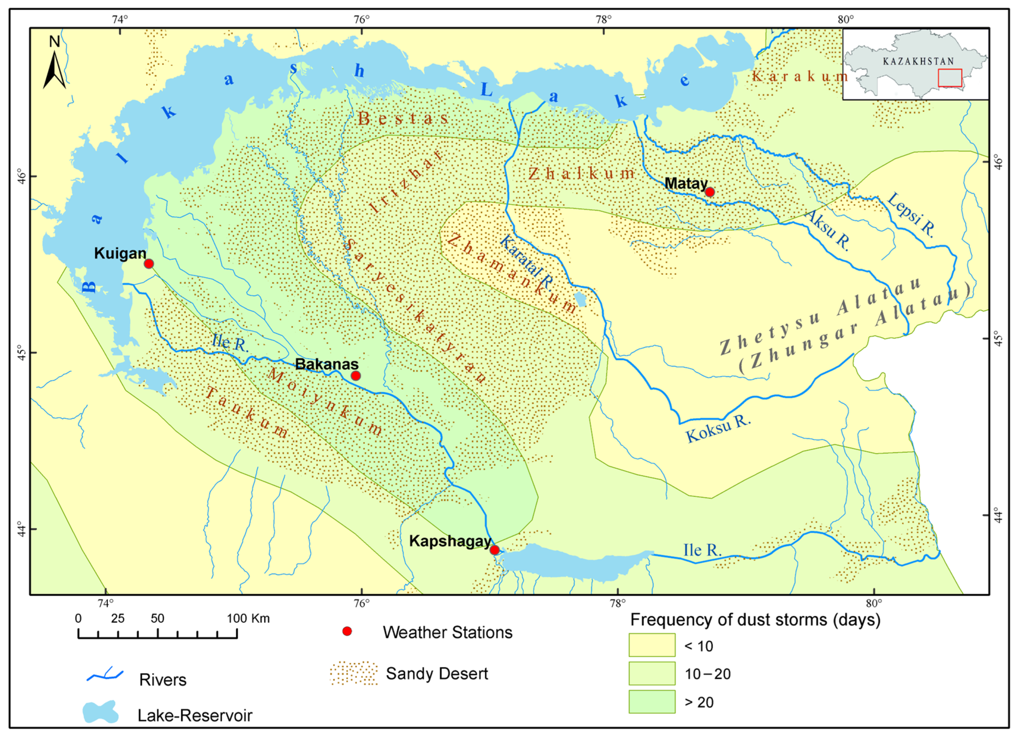
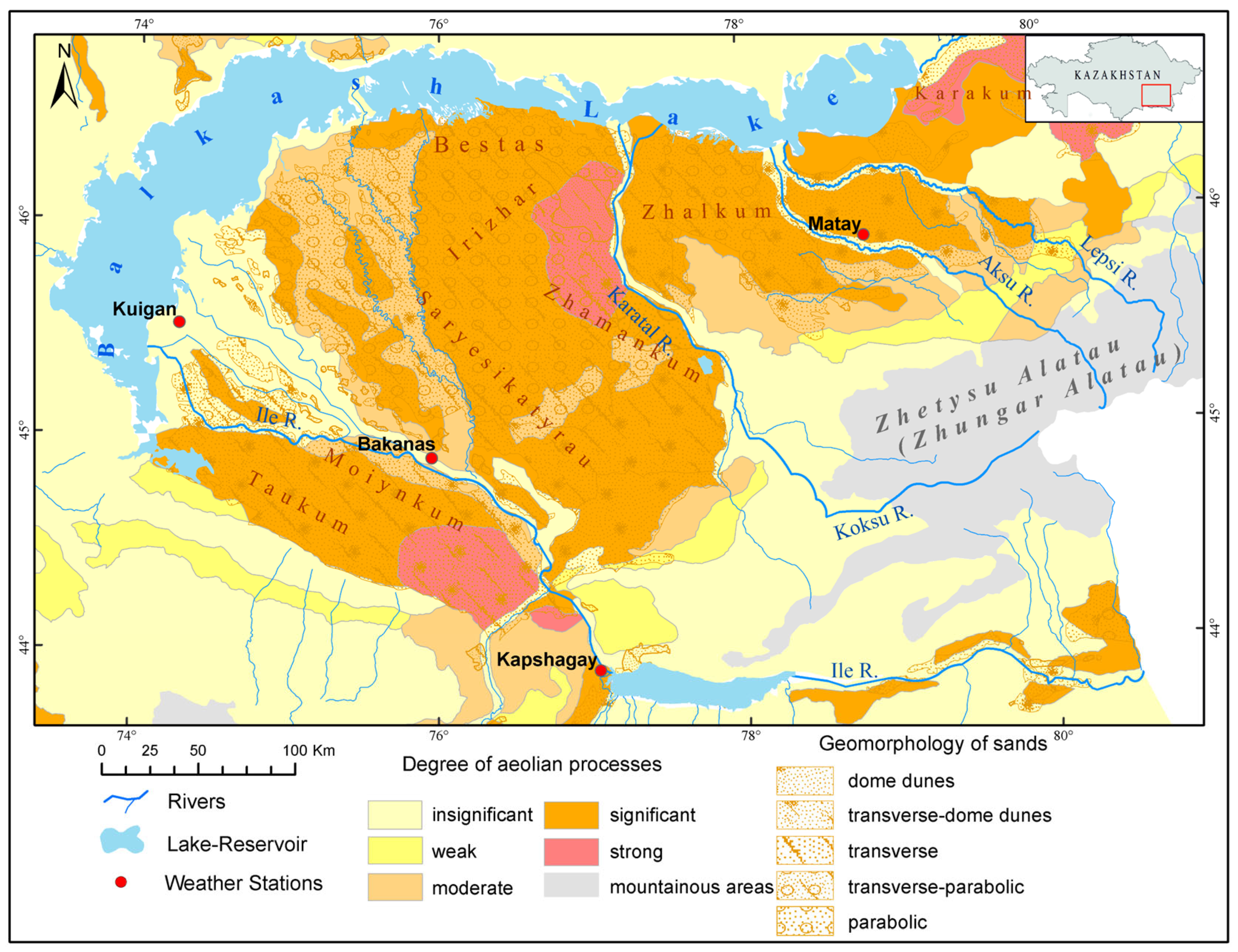
2.1. Overview of the Study Area

The Southern Balkash deserts, with a vast area of about 70,000 km2, belong to sandy deserts according to features of the formation of the deserts of the study region [12]. It is located in southeast Kazakhstan within the shallow Balkash-Alakol depression and in the Balkash lowland, an accumulative plain gently sloping toward the north with a minimum absolute elevationof 340 m. It is divided in the north by the southern slopes of the Saryarka; in the west and south by the Shu-Ile watershed plateau; and in the southeast by the ridges of the Zhetysu Alatau (Figure 1). The desert is located in the zone of gray soils (serozems) interspersed with locally developed, mainly takyr-like solonchak, and meadow-boggy soils. The vegetation cover here is represented by wormwood and feather grass. Additionally, large areas are occupied by sandy desert soils developed in massifs of semi-fixed aeolian sands, where white haloxylon, calligonum, krascheninnikovia, and wormwood are found. Takyr-like soils are formed in drainless basins of dried-up lakes and are predominantly saline.
The climate of the deserts is continental and arid [48]. The Southern Balkash is described by large daily and annual fluctuations in air temperature and has a high solar radiation level and a long dry summer period. The air temperature in January is an average of −16 °C in the northern part, the southern part of the plain territory is −5 °C, and the mean temperature is about 20–25 °C; in July. In summer, the precipitation completely evaporates on the plain. The most significant monthly precipitation falls in spring (April–May) and the least falls in February and August–September [20]. The water balance of Balkash Lake mainly depends on the flow of the rivers of the Southern Balkash region, mainly from the Ile River. The Ile River crosses the desert, flowing into the lake. Some rivers flowing down the slopes of the Zhetysu Alatau also cross the Saryesikatyrau desert, flowing into Balkash Lake. Other smaller rivers are lost in the sands (Figure 1).

2.2. Dust Storm and Wind Data

“Dataset on dust storm climatology and wind regime for Kazakhstan” issued by KazHydromet (Kazakhstan) provides the dust storm and wind regime data from all the meteorological stations within Kazakhstan, which offers great advantages for dust activity studies. In the present study, the average monthly number of days in the dust storm data of four stations from the above dataset, namely the Bakanas, Kuigan, Matay, and Kapshagay, was used to characterize the variation of dust storm and wind directions in the Southern Balkash deserts. Statistical methods were used to analyze the long-term dynamics and seasonal frequency of dust storms by the average number of dusty days for 1971–2020 and in different months for 1966–2003, respectively. The wind rose of the four meteorological stations was built according to the wind direction data from 1966 to 2003 derived from the “Dataset on dust storm climatology and wind regime for Kazakhstan”.
The spatial distribution of wind speed was based on gridded mean wind speed data from Global Wind Atlas version 3.1. It is developed, owned, and operated by the Technical University of Denmark (DTU) and contains all new data on wind resources around the world. As such, it can be used to identify global, national, regional, and local high-wind areas. Global Wind Atlas has made high-resolution climate and wind statistical data available to users through their geoportal (http://globalwindatlas.com/, accessed on 15 September 2021). The resolution of gridded data is 1 km [49]. The mean wind speed calculated at a height of 100 m and every 250 m on land surfaces was used in the present study.

2.3. Archive Cartographic Materials

Numerous archive cartographic materials with information on soil texture [50] and plant communities [51] were selected to investigate the sources of aeolian processes and dust storms in the Southern Balkash deserts in Kazakhstan.
Firstly, the archive cartographic materials were vectorized. Then, the spatial distribution of dust storms was analyzed using geostatistical methods in Arc Map. As a result, on the vectorized cartographic map, the present study defined the relationship between the origin of dust storms and soil texture with plant communities, identified the sources of sand and dust storms shown on the map, and estimated the area of storms of different degrees.
Initial topographic information and the geomorphological types of sands were obtained from Soviet topographic maps at 1:500,000 scales. The degree of manifestation of aeolian processes and the degree of desertification were derived from the maps of the National Atlas of Kazakhstan [52]. The overlaying of thematic layers in a GIS environment was performed to analyze the regional distribution of and the spatial relationship bewteen sands and aeolian processes.

3. Results and Discussion

3.1. Geology and Geomorphology of the Southern Balkash Deserts

The Southern Balkash depressions were located in the deserts that took shape in the Neogene. Paleogene deposits are found mainly on the periphery. Paleogene and Neogene formations lie like a mantle on the leveled surface of the Paleozoic. In the Quaternary period, the active formation of the relief was accompanied by the accumulation and redistribution of deposits. This process developed against intense tectonic movements and climate fluctuations, which caused great diversity in the genesis of Quaternary deposits and significant differences in their thicknesses [53]. Modern aeolian deposits are widespread in the Southern Balkash depression. Their composition is feldspar-quartz. Granites, amphiboles, mica, chlorite, and epidote are found in trace levels in the sands; apatite, hematite, pyroxene, and sphene are less prevalent [54]. According to the geomorphology of the sands, the transverse parabolic sands (48%) are dominant in the region, and they cover Saryesikatyrau, Bestas, Zhamankum, and Irizhar sands. Dome dunes (24%) cover the eastern sands, including the Karakum and the southern part of the Saryesikatyrau. Transverse-dome dunes cover the Taukum and Moiynkum deserts with an area of 23% to form the territory of the Southern Balkash deserts (Figure 1).
The ridges of the Bestas sands extend in a northwesterly direction. Their height is 6–8 m, their width is several tens of meters, and their length is up to 200 m; rarely are ridges 8–20 m high. The ridges are slightly soddy and covered with a characteristic powder—coarse sand [55]. The height of the ridges and mounds of the Moiynkum sands is 2–6 m, occasionally reaching 15 m. The direction of the strike of the ridges is north and northwest. The slopes are gentle. The structure of the ridges is the same as that in the Bestas sands. The sands are well-fixed by vegetation. The southern shore of Balkash Lake, along the entire lake, adjoins the coastal lacustrine-saline plain with an area of more than 27 thousand km². The greatest width reaches 30 km. Dense crusts of salts on the surface and vast regions of solonetzes and plump solonchaks can be sources of salt aerosols. The aeolian relief is represented by chains of coastal dunes and dunes up to 8 m high and sometimes form complex star-shaped dunes that are 10–15 m high [56].

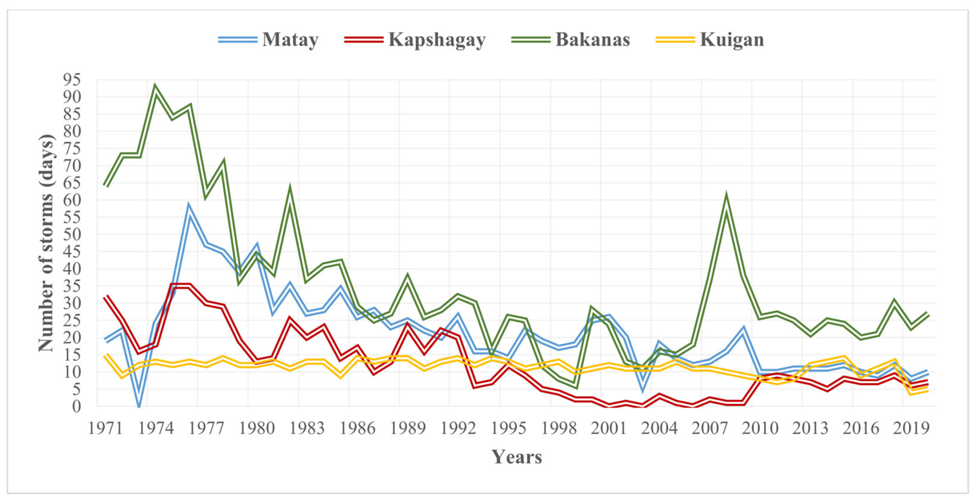
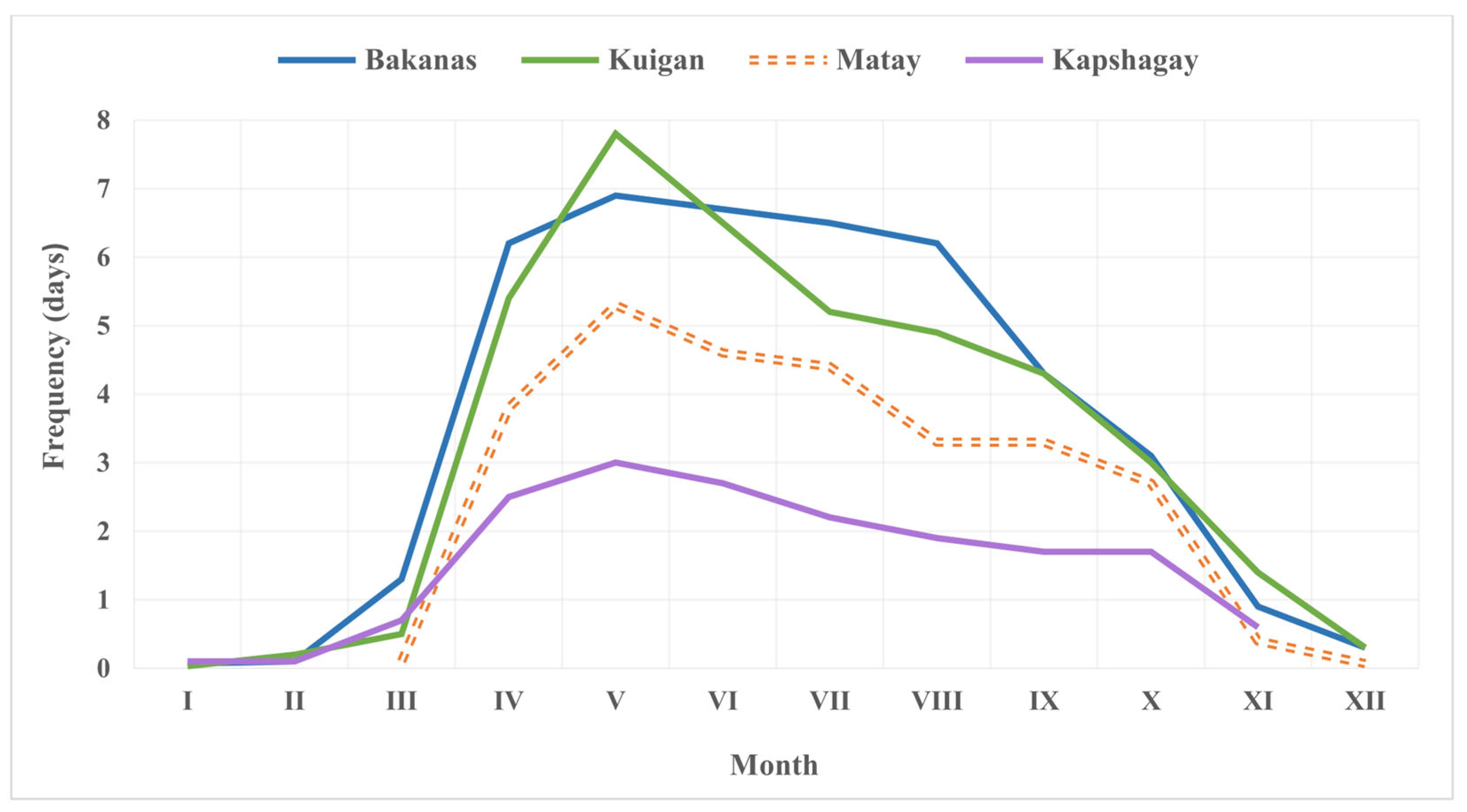
3.2. Spatial and Temporal Characteristics of Dust Storms in the Southern Balkash Deserts

Sand and dust storms occurring at different frequencies and for different durations are common in arid and semi-arid regions in Kazakhstan and Central Asia, which develop intensive soil deflation and contribute to the spread of desertification. According to analyses of observation data from weather stations, storms are typical almost all over Kazakhstan with its continental climate, the high wind speed (≥6 m/s) regime, frequent soil and atmospheric droughts, and the scarcity of vegetation cover [57]. The broad diversity characterizes the spatial distribution of the storms in the Southern Balkash deserts.
The Southern Balkash deserts in Kazakhstan are regions with the most frequent storms. (Figure 2). Dust storms, occurring at a frequency of more than 20 days, are common in the coastal areas of the Balkash Lake and Ile River basin, primarily in Moiynkum, Bestas, and western Saryesi-katyrau sands. In addition, the Taukum, Zhalkum, Irizhar, and Saryesikatyrau deserts are subject to dust storms at a frequency of 10–20 days per year. Mountainous areas were comparatively less prone to dust storms. The frequency of their occurrence was <10 days/year (Figure 2). The annual amount of days with deflationary processes in the form of storms reached 30–90 days in the Moiynkum and Taukum deserts, decreasing to 10–20 days in the foothills of the Zhetysu (Zhungar) Alatau [36].
The Bakanas region showed a large number of storms because of takyr-like soils containing clay particles and many silty sand sediments that are prone to the soil deflation process. In addition, this region was affected by human activity, particularly irrigation agriculture and the water supply for electric energy production from water reservoirs [58]. The overall dynamics of the storms have shown an increasing trend since the 1970s up to 1988 (Figure 3) and can be explained by the establishment of the Kapshagay water reservoir in the 1970s. The Balkash Lake area has shrunk to 4700 km2 due to intensive water use from the Ile, Karatal, and Lepsi rivers [20]. Consequently, a significant part of the coastal area was exposed to salinity and soil degradation. Due to the regulation and reduction of the river flows of the Ile and Karatal, many lakes are drying, including the salt lakes in the deltas [58]. As a result, new sources of dust/sand storms, leading to high concentrations of salt in atmospheric streams, have appeared in the deserts of the Southern Balkash. These salts provoke the deterioration of pasture conditions, and the reduction of biodiversity, salinity, and desertification in general.
The geographical location and climatic features of Kazakhstan are variable with its large territory. Consequently, storm activities differ with annual and inter-annual variability. For example, the spring and summer seasons are more favorable to storm outbreaks. According to the data analysis of storms in the Southern Balkash deserts, two peaks were detected from 1966 to 2003: in April–June and July–September (Figure 4).
Because of the sharp rise in temperature and high wind speed in the spring [59], the surface of southern deserts deteriorates in theintensive evaporation of humidity, which, together with strong winds, contributes to the development of dust and sand storm phenomena. As a result, the southern deserts of the Balkash (meteorological stations: Bakanas, Kuigan, and Matay) are one of the main areas of Kazakhstan where regular storms occur, especially in the period from April to August and April–September (Figure 4). The average annual duration of storms for the period 1966–2003 was 43 days at the Bakanas meteorological station, 40 days at the Kuigan station, and 28 and 17 days per year at the Matay and Kapshagay stations, respectively.

3.3. Wind Regime and Wind Direction in the Southern Balkash Deserts

In Kazakhstan, the wind regime mostly has a continental character. It is conditioned mainly by local barik-circulation conditions, depending on orographic features, sun exposure, and topography [60]. The wind speed is variable within Kazakhstan, and it is high mainly in the desert zone. Almost 50% of the territory of Kazakhstan has an annual wind speed of an average of 4–5 m/s. It can reach a speed of ≥6 m/s in the Caspian Sea’s coastal areas, mountain passes, and corridors in the south and southeast of Kazakhstan. In the Southern Balkash deserts, wind speed ranges from 0.5 m/s in the mountainous areas to 8 m/s toward the deserts (Figure 5). The maximum wind speeds occur in the spring—summer period, meaning that deflation processes are intense at this time [61,62].
The aeolian process in deserts is a regular phenomenon, and the wind regime is related to baric topography and climatic conditions. Wind regime defines the speed and direction of the movement of wind in a particular desert area [12,20]. In the Southern Balkash deserts, the western winds are dominant and controlled by the general circulation of air masses in southeastern Kazakhstan [36,56]. Consequently, the sand movement directions are northeast, southeast, and east (the Bakanas, Matay, and Kuigan stations) (Figure 5). The direction and speed of the movement of active dunes mainly depend on the relief, and local orographic conditions play their role in the appearance of winds. Therefore, wind of a westerly direction is observed at the Kapshagay station. This is due to a well-known local easterly mountain and valley, “Shelek”, and the wind and orographic condition of the region. It is created by transferring cold air from the part of the Ile Alatau that is a glacierized zone in the headwaters of the Shelek River to the Ile River valley (Figure 5). The mean annual wind speed is 8–10 m/s [63]. The character of mountain-valley winds depends on the height of the local topography, the slope exposure, and the gorge directions.
Considering this, the direction of the wind could either coincide or not coincide with the regular nature of the winds of the surrounding plains, i.e., they can either increase or decrease the overall strength of the wind [20]. In addition, local air circulation in the region prevails over the general atmospheric circulation [64,65]. That is why the local winds are often vital in the region and steadily blowing. They are noted in the surrounding area of mountain spurs and gorges [12].
Strong winds can erode and move a large number of small particles, deposit them elsewhere, and form dunes in a desert or on a beach. Consequently, wind is one of the main relief-forming factors in a sandy desert. Additionally, strong winds cause dust and sand storms in the Taukum, Moiynkum, and Saryesikatyrau deserts, and sand with different-sized particles can transport from the surface and accumulate elsewhere. In deserts, winds cross the threshold speed of 6 m/s cause sand deflation [66,67,68]. Windy, dry weather with a wind speed of 6 m/s was observed on 60 to 127 days/year in the Southern Balkash deserts; such weather occurred on 80–100 days per year in most areas of the Saryesikatyrau and Taukum sands; the occurrence of this weather reached up to 100–120 days/year in the southern shore of Balkash Lake [67,68].

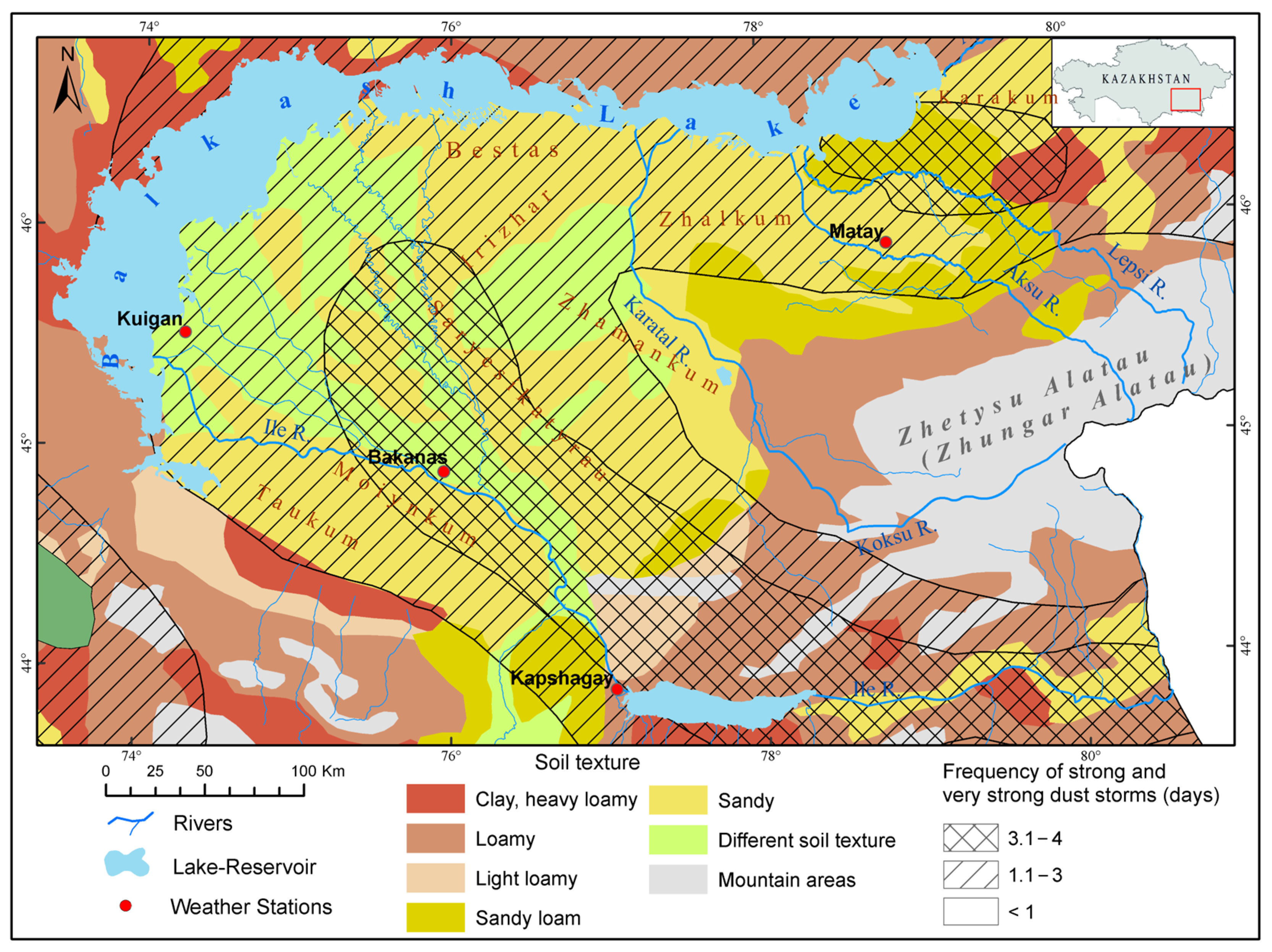
3.4. The Relationship between Strong and Very Strong Dust Storm Origin and Soil Texture

A strong dust storm in Kazakhstan occurs when the wind speed is 10–14 m/s with visibility from 500 m to 1000 m [69]. They last from 3 to 12 h. Storms lasting 12 h with a wind speed of >15 m/s and a visibility decrease to ≥50 m are extreme storms [57,70]. Severe and extreme dust storms last 3.1−4 days and largely cover the Ile River valley, the eastern half of the Moiynkum desert, and the Saryesikatyrau desert (Figure 6). These are agricultural areas with wind speeds surpassing >8 m/s and predominantly light-composed soils (soil particle size > 250 microns), as well as the dryness of sandy deserts with minimal vegetation cover, result in powerful dust storms [56]. The dust storms covering the areas in the Southern Balkash deserts can be considered in three groups of the following frequencies: 3.1–4 days (20%), 1.1–3 days (48%), and one day(32%) in the whole region of deserts.
Soil texture is a critical soil feature defining the soil surface’s resistance to wind erosion or soil deflation. Soil textures include lightly and heavily loamy, loamy, sandy loam, sandy, clay, and soils of various compositions (Figure 6). As is well-known, the potential and active sources of dust storms are distributed in soils with a light texture (sandy loam and sandy) that are prone to soil deflation (Figure 6).
The sources of strong and very strong dust storms with frequencies of 1.1–3 days and 3.1–4 days per year are found mainly in areas with high wind speed and light-textured soils (Figure 6). Furthermore, such places are located in regions of sandy deserts with sparse vegetation or sometimes barren dunes. In addition, the parts were used intensively for agricultural purposes and industrial development. Moreover, the light-textured soils or sands with a psammophytic plant community are the source for the outbreak of aerosols of different sizes in the atmosphere can be clearly noticed by monitoring from space satellites [59,71].
Since the plant community plays its role in forming dust/sand storms, according to the edaphic deserts map analysis of Middle Asia, the psammophytic vegetation is vulnerable to dust and sand storms. Therefore, the Edaphic deserts with psammophytic plant communities are distributed in vast sandy massifs such as the Kyzylkum, Moiynkum, Aral Karakum, Southern Balkash deserts (Saryesiktyrau and Taukum) [51].

3.5. Aeolian Processes in the Southern Balkash Deserts

The aeolian process, closely related to weathering processes, is widely developed and distributed in the arid zone, particularly in deserts. It first appeared in the second half of the Middle Quaternary era [53] and continue to this day: deflationary basins are being worked out; sandy mounds, dunes, and rows are winding up; and the most considerable total thickness of aeolian deposits in the Southern Balkash deserts reaches 25–30 m [72,73].
Aeolian processes are actively manifested in the sandy and sandy loam deposits of the Southern Balkash deserts, which are locally weakly fixed by vegetation. Silty sands and light sandy loams are intensively blown and contribute to the formation of large massifs of scattered sands in the Southern Balkash deserts. The sandy massifs of the Southern Balkash deserts, such as the Taukum, Saryesikatyrau, and Moiynkum deserts, have an elongated direction due to the northwestern and northeastern winds and aeolian processes that partly took part in their formation. According to the composed map, the degree of the occurrence of the aeolian process is significant and strong in most of the Southern Balkash deserts (Figure 7). In the Taukum sandy massifs, aeolian processes are most active in spring [56], and its eastern part is prone to them to a strong degree (Figure 7). As well as the northern part of the Zhamankum sands (the left bank of the Karatal river) and Karakum sands (eastern coast of the Balkash Lake) are subject to the aeolian process to a strong degree (Figure 7).
The accumulation of aeolian deposits is associated with local, regional, and global atmospheric processes (strong winds, heavy rains, etc.), and the deposits can be found everywhere [74]. Heavy rains contribute to the movement of a significant amount of fine earth on the slopes. Erosion furrows are formed at 5–10 cm in deep and inter-ridge depressions, and dry channels are formed at 10–20 cm. Deflation and aeolian accumulation quickly destroy these forms of aeolian relief [75]. The intensity of the manifestation of aeolian accumulation processes is clearly pronounced within the modern lacustrine sloping swampy plain. The plain comprises lacustrine-marsh deposits, partly fine-grained silty sands overlain by aeolian sands. They were formed due to the wind processing of sandy beaches and the inflow from the central parts of the Taukum sandy massif. Intense deflation zones are confined to the elevated southeastern part of the Taukum (Figure 7). Under the influence of southwestern and northeastern winds, sand is continuously blown and accumulates in depressions between ridges. Local deflation processes occur in fixed transverse-dome dunes in the Taukum and on the border of the Saryesikatyrau and Moiynkum sands.

4. Conclusions

In the present study, a dataset on dust storm climatology and wind regime and archive cartographic materials, coupled with classical statistical methods and geostatistical methods, were used to study the spatial and temporal characteristics of dust storms and aeolian processes in the Southern Balkash deserts in Kazakhstan, Central Asia. The main results and conclusions were drawn as follows.
Transverse-parabolic sands (48%) dominate the Southern Balkash deserts, and dome dunes (24%) cover the eastern sands, including the Karakum and the southern part of the Saryesikatyrau. Transverse-dome dunes cover 23% of the territory of the Southern Balkash deserts.
Dust storms with a frequency of >20 days are distributed in the Balkash Lake and Ile River valley coastal areas. The Bakanas region shows a large number of storms because of takyr-like soils containing clay particles and many silty sand sediments that are prone to the soil deflation process. The Moiynkum, Bestas, Saryesikatyrau, and Taukum deserts are the areas with the most frequent sand and dust storms (17 to 43 days/per year). The occurrence of and and dust storms has steadily decreased since the 1990s, except for 2008–2009. Seasonally, two peaks (April–June and July–September) of sand and dust storms were detected between 1966 and 2003.
The sources of strong and very strong dust storms in the Southern Balkash deserts, with a frequency of 1.1–3 days and 3.1–4 days per year, are found primarily in areas with a high wind speed and light-textured soils. The degree of the occurrence of aeolian processes is significant and strong in most Southern Balkash deserts. Aeolian dust flows mainly from the western and southwestern directions to the eastern and northeastern directions.
This study can be considered the first attempt at revealing the temporal and spatial characteristics of dust storms and aeolian processes in the Southern Balkash deserts, which allows an assessment of the intensity of modern soil deflation processes and predicts the possibility of sand movement in the Southern Balkash deserts. In the future, we will continue to carry out research on the impact of wind erosion on desertification, dust emission flux, and the prevention of desertification in the Southern Balkash deserts by conducting an observation and model simulation. This will be of great importance to the monitoring and early warning of dust storms and sustainable development in this region.

Author Contributions

Conceptualization and methodology, G.I.; software, G.I. and A.K.; formal analysis, G.I., Y.G. and A.K.; investigation, G.I. and A.K.; data curation and writing—original draft preparation, writing—review and editing, G.I., Y.G. and L.M.; visualization, G.I., Y.G. and A.K.; supervision, project administration, and funding acquisition, Y.G. and J.A. All authors have read and agreed to the published version of the manuscript.

Funding

This research was sponsored by the Youth Innovation Promotion Association of CAS (2023459), National Natural Science Foundation of China (42171014), Natural Science Foundation of Xinjiang Uygur Autonomous Region (2022D01A153, 2022D01A352), the Postdoctoral Fellowship provided by Al-Farabi Kazakh National University, and the Foundation of State Key Laboratory of Desert and Oasis Ecology, Xinjiang Institute of Ecology and Geography Chinese Academy of Sciences.

Data Availability Statement

The data presented in this study are available on request from the corresponding author.

Acknowledgments

Our gratitude goes to M. Stambekov for partly providing weather station data on dust storms in the present study. The authors would like to thank the editors for their assistance with the manuscript, as well as the reviewers for their positive and informative comments and suggestions, which significantly improved the manuscript.

Conflicts of Interest

The authors declare no conflict of interest.

References

  1. Shen, H.; Abuduwaili, J.; Samat, A.; Ma, L. A review on the research of modern aeolian dust in Central Asia. Arab. J. Geosci. 2016, 9, 625. [Google Scholar] [CrossRef]
  2. Orlovsky, N.S.; Orlovsky, L.; Indoitu, R. Severe dust storms in Central Asia. Arid Ecosyst. 2013, 3, 227–234. [Google Scholar] [CrossRef]
  3. Cao, H.; Liu, J.; Wang, G.; Yang, G.; Luo, L. Identification of sand and dust storm source areas in Iran. J. Arid Land 2015, 7, 567–578. [Google Scholar] [CrossRef]
  4. Hu, Q.; Han, Z. Northward Expansion of Desert Climate in Central Asia in Recent Decades. Geophys. Res. Lett. 2022, 49, e2022GL098895. [Google Scholar] [CrossRef]
  5. Monforte, P.; Ragusa, M.A. Temperature Trend Analysis and Investigation on a Case of Variability Climate. Mathematics 2022, 10, 2202. [Google Scholar] [CrossRef]
  6. Indoitu, R.; Orlovsky, L.; Orlovsky, N. Dust storms in Central Asia: Spatial and temporal variations. J. Arid Environ. 2012, 85, 62–70. [Google Scholar] [CrossRef]
  7. Lioubimtseva, E.; Cole, R.; Adams, J.; Kapustin, G. Impacts of climate and land-cover changes in arid lands of Central Asia. J. Arid Environ. 2005, 62, 285–308. [Google Scholar] [CrossRef]
  8. Al-Dousari, A.M.; Al-Awadhi, J.; Ahmed, M. Dust fallout characteristics within global dust storm major trajectories. Arab. J. Geosci. 2013, 6, 3877–3884. [Google Scholar] [CrossRef]
  9. Galayeva, O.; Semenov, O. Sand transportation by wind in the Aral Sea region. Hydrometeorol. Ecol. 2011, 3, 73–85. [Google Scholar]
  10. Goudie, A. Dust storms and their geomorphological implications. J. Arid Environ. 1978, 1, 291–311. [Google Scholar] [CrossRef]
  11. Middleton, N.; Kang, U. Sand and dust storms: Impact mitigation. Sustainability 2017, 9, 1053. [Google Scholar] [CrossRef] [Green Version]
  12. Babaev, A.G. Desert Problems and Desertification in Central Asia: The Researchers of the Desert Institute; Springer Science & Business Media: Berlin/Heidelberg, Germany, 2012. [Google Scholar]
  13. Parakshina, E.; Saparov, A.; Mirzakeev, E. Soil Erosion in Kazakhstan. Almaty Poligraphy-Serv. 2010. (In Russian) [Google Scholar]
  14. Middleton, N.J. Desert dust hazards: A global review. Aeolian Res. 2017, 24, 53–63. [Google Scholar] [CrossRef]
  15. Medeu, A.R. Republic of Kazakhstan: Environment and Ecology; The Institute of Geography ltd., National science and technology centre «Parasat»: Almaty, Kazakhstan, 2010; p. 520. (In Russian) [Google Scholar]
  16. Karami, S.; Hamzeh, N.H.; Kaskaoutis, D.G.; Rashki, A.; Alam, K.; Ranjbar, A. Numerical simulations of dust storms originated from dried lakes in central and southwest Asia: The case of Aral Sea and Sistan Basin. Aeolian Res. 2021, 50, 100679. [Google Scholar] [CrossRef]
  17. Prospero, J.M.; Ginoux, P.; Torres, O.; Nicholson, S.E.; Gill, T.E. Environmental characterization of global sources of atmospheric soil dust identified with the Nimbus 7 Total Ozone Mapping Spectrometer (TOMS) absorbing aerosol product. Rev. Geophys. 2002, 40, 1002. [Google Scholar] [CrossRef]
  18. Zhou, C.; Gui, H.; Hu, J.; Ke, H.; Wang, Y.; Zhang, X. Detection of New Dust Sources in Central/East Asia and Their Impact on Simulations of a Severe Sand and Dust Storm. J. Geophys. Res. Atmos. 2019, 124, 10232–10247. [Google Scholar] [CrossRef] [Green Version]
  19. Al-Dabbas, M.A.; Ayad Abbas, M.; Al-Khafaji, R.M. Dust storms loads analyses—Iraq. Arab. J. Geosci. 2012, 5, 121–131. [Google Scholar] [CrossRef]
  20. Issanova, G.; Abuduwaili, J.; Oleg, S. Deflation processes and their role in desertification of the southern Pre-Balkhash deserts. Arab. J. Geosci. 2014, 7, 4513–4521. [Google Scholar]
  21. Orlovsky, L.; Orlovsky, N.; Durdyev, A. Dust storms in Turkmenistan. J. Arid Environ. 2005, 60, 83–97. [Google Scholar] [CrossRef]
  22. Orlovsky, L.; Tolkacheva, G.; Orlovsky, N.; Mamedov, B. Dust storms as a factor of atmospheric air pollution in the Aral Sea basin. WIT Trans. Ecol. Environ. 2004, 74, 353–362. [Google Scholar]
  23. Squires, V.R. Dust and sandstorms: An early warning of impending disaster. In Global Alarm: Dust and Sandstorms from World’s Drylands; United Nations: New York, NY, USA, 2001; pp. 15–28. [Google Scholar]
  24. Groll, M.; Opp, C.; Aslanov, I. Spatial and temporal distribution of the dust deposition in Central Asia–results from a long term monitoring program. Aeolian Res. 2013, 9, 49–62. [Google Scholar] [CrossRef]
  25. Indoitu, R.; Kozhoridze, G.; Batyrbaeva, M.; Vitkovskaya, I.; Orlovsky, N.; Blumberg, D.; Orlovsky, L. Dust emission and environmental changes in the dried bottom of the Aral Sea. Aeolian Res. 2015, 17, 101–115. [Google Scholar] [CrossRef]
  26. O’Hara, S.L.; Wiggs, G.F.; Mamedov, B.; Davidson, G.; Hubbard, R.B. Exposure to airborne dust contaminated with pesticide in the Aral Sea region. Lancet 2000, 355, 627–628. [Google Scholar] [CrossRef]
  27. Opp, C.; Groll, M.; Aslanov, I.; Lotz, T.; Vereshagina, N. Aeolian dust deposition in the southern Aral Sea region (Uzbekistan): Ground-based monitoring results from the LUCA project. Quat. Int. 2017, 429, 86–99. [Google Scholar] [CrossRef]
  28. Orlovsky, L.; Orlovsky, N. White Sand Storms in Central Asia. In Global Alarm: Dust and Sand Storms from the World’s Drylands; United Nations: New York, NY, USA, 2001; pp. 169–201. [Google Scholar]
  29. Mischke, S.; Liu, C.; Zhang, J.; Zhang, C.; Zhang, H.; Jiao, P.; Plessen, B. The world’s earliest Aral-Sea type disaster: The decline of the Loulan Kingdom in the Tarim Basin. Sci. Rep. 2017, 7, 43102. [Google Scholar] [CrossRef] [PubMed] [Green Version]
  30. Ge, Y.; Abuduwaili, J.; Ma, L.; Wu, N.; Liu, D. Potential transport pathways of dust emanating from the playa of Ebinur Lake, Xinjiang, in arid northwest China. Atmos. Res. 2016, 178–179, 196–206. [Google Scholar] [CrossRef]
  31. Wu, N.; Ge, Y.; Abuduwaili, J.; Issanova, G.; Saparov, G. Insights into Variations and Potential Long-Range Transport of Atmospheric Aerosols from the Aral Sea Basin in Central Asia. Remote Sens. 2022, 14, 3201. [Google Scholar] [CrossRef]
  32. Isbekov, K.B.; Tsoy, V.N.; Crétaux, J.F.; Aladin, N.V.; Plotnikov, I.S.; Clos, G.; Berge-Nguyen, M.; Assylbekova, S.Z. Impacts of water level changes in the fauna, flora and physical properties over the Balkhash Lake watershed. Lakes Reserv. Sci. Policy Manag. Sustain. Use 2019, 24, 195–208. [Google Scholar] [CrossRef]
  33. Iskakov, N.A.; Medeu, A.R. Republic of Kazakhstan: Natural Resources and Conditions; Ministry for Environmental Protection: Almaty, Kazakhstan, 2006; Volume 1. (In Russian) [Google Scholar]
  34. Kovda, V.A. Problems of Desertification and Soil Salinization in Arid Territories of the World; Nauka: Moscow, Russia, 2008; p. 415. (In Russian) [Google Scholar]
  35. Matinfar, H.R.; Alavi Panah, S.K.; Zand, F.; Khodaei, K. Detection of soil salinity changes and mapping land cover types based upon remotely sensed data. Arab. J. Geosci. 2013, 6, 913–919. [Google Scholar] [CrossRef]
  36. Skotselias, I.I. Actual hydrometeorological problems of Balkhash Lake and Pre-Balkhash region. Saint Petersburg. Gidrometeoizdat 1995. (In Russian) [Google Scholar]
  37. Sills, J.; Ussenaliyeva, A. Save Kazakhstan’s shrinking Lake Balkhash. Science 2020, 370, 303. [Google Scholar] [CrossRef]
  38. Sills, J.; Aladin, N.V.; Høeg, J.T.; Plotnikov, I. Small Aral Sea brings hope for Lake Balkhash. Science 2020, 370, 1283. [Google Scholar]
  39. Duan, W.; Zou, S.; Chen, Y.; Nover, D.; Fang, G.; Wang, Y. Sustainable water management for cross-border resources: The Balkhash Lake Basin of Central Asia, 1931–2015. J. Clean. Prod. 2020, 263, 121614. [Google Scholar] [CrossRef]
  40. Myrzakhmetov, A.; Dostay, Z.; Alimkulov, S.; Tursunova, A.; Sarsenova, I. Level regime of Balkhash Lake as the indicator of the state of the environmental ecosystems of the region. Paddy Water Environ. 2022, 20, 315–323. [Google Scholar] [CrossRef]
  41. Cherednichenko, A.V.; Cherednichenko, A.V.; Cherednichenko, V.S.; Storozhenko, N.D.; Kozhachmetova, E.P.; Kupchishin, A.I.; Abdrahimov, R.G. Dynamic of Balkhash lake level under climate change conditions. IOP Conf. Ser. Earth Environ. Sci. 2019, 321, 012012. [Google Scholar] [CrossRef] [Green Version]
  42. Shen, B.; Wu, J.; Zhan, S.; Jin, M.; Saparov, A.S.; Abuduwaili, J. Spatial variations and controls on the hydrochemistry of surface waters across the Ili-Balkhash Basin, arid Central Asia. J. Hydrol. 2021, 600, 126565. [Google Scholar] [CrossRef]
  43. Shen, B.; Wu, J.; Zhan, S.; Jin, M. Spatial Distributions, Sources and Risk Assessment of Toxic Elements in Waters of a Central Asian Basin. Water Resour. Manag. 2022, 36, 6187–6203. [Google Scholar] [CrossRef]
  44. Mischke, S.; Zhang, C.; Plessen, B. Lake Balkhash (Kazakhstan): Recent human impact and natural variability in the last 2900 years. J. Great Lakes Res. 2020, 46, 267–276. [Google Scholar] [CrossRef]
  45. Sala, R.; Deom, J.-M.; Aladin, N.V.; Plotnikov, I.S.; Nurtazin, S. Geological History and Present Conditions of Lake Balkhash. In Large Asian Lakes in a Changing World: Natural State and Human Impact; Mischke, S., Ed.; Springer International Publishing: Cham, Switzerland, 2020; pp. 143–175. [Google Scholar]
  46. Gholami, H.; Mohammadifar, A.; Malakooti, H.; Esmaeilpour, Y.; Golzari, S.; Mohammadi, F.; Li, Y.; Song, Y.; Kaskaoutis, D.G.; Fitzsimmons, K.E.; et al. Integrated modelling for mapping spatial sources of dust in central Asia—An important dust source in the global atmospheric system. Atmos. Pollut. Res. 2021, 12, 101173. [Google Scholar] [CrossRef]
  47. Nobakht, M.; Shahgedanova, M.; White, K. New Inventory of Dust Emission Sources in Central Asia and Northwestern China Derived From MODIS Imagery Using Dust Enhancement Technique. J. Geophys. Res. Atmos. 2021, 126, e2020JD033382. [Google Scholar] [CrossRef]
  48. Issanova, G.; Abuduwaili, J. Introduction and Status of Storms in Central Asia and their Environmental Problems. In Aeolian proceses as Dust Storms in the Deserts of Central Asia and Kazakhstan; Springer Singapore: Singapore, 2017; pp. 1–27. [Google Scholar]
  49. Badger, J.; Hahmann, A.; Larsén, X.G.; Badger, M.; Kelly, M.; Olsen, B.T.; Mortensen, N.G. The Global Wind Atlas: An EUDP Project Carried out by DTU Wind Energy; DTU Orbit: Copenhagen, Denmark, 2015. [Google Scholar]
  50. Issanova, G.; Abuduwaili, J.; Kaldybayev, A.; Semenov, O.; Dedova, T. Dust storms in Kazakhstan: Frequency and division. J. Geol. Soc. India 2015, 85, 348–358. [Google Scholar] [CrossRef]
  51. Akzhygitova, N.; Breckle, S.; Winkler, G.; Volkova, E.; Wucherer, W.; Kurochkina, L.; Makulbekova, G.; Ogar, N.; Rachkovskaya, E.; Safronova, I. Botanical Geography of Kazakhstan and Middle Asia (Desert Region); Komarov Botanical Institute of the Russian Academy of Sciences: Saint Petersburg, Russia, 2003. [Google Scholar]
  52. National Atlas of Kazakhstan (NAKZ). Environment and ecology. 2010, 3. (In Russian)
  53. Muhs, D.R. The geologic records of dust in the Quaternary. Aeolian Res. 2013, 9, 3–48. [Google Scholar] [CrossRef] [Green Version]
  54. Nikitin, S.A. Sands of the Western Balkash. In Proceedings of the Dokuchaev Soil Institute, Part 11, 1935; pp. 147–226. (In Russian). [Google Scholar]
  55. Dedova, T.V.; Semenov, O.F.; Tuseeva, N.B. Division of Kazakhstan territory by the repetition of very strong dust storms and based on meteorological observations, remote sensing images and GIS. In Republic of Kazakhstan: Environment and Ecology; Iskakov, T.B., Medeu, A.R., Eds.; Almaty, Kazakhstan, 2006. (In Russian) [Google Scholar]
  56. Semenov Oleg, E. Introduction to Experimental Meteorology and Climatology of Sand Storms, 2nd ed.; Fizmatkniga: Moscow, Russia, 2020; 448p. [Google Scholar]
  57. Kudekov, T. Modern ecological condition of Balkhash Lake basin. Kaganat Almaty 2002, 388. (In Russian) [Google Scholar]
  58. Belgibayev, I. Desertification and some ecological problems of Southern Pre-Balkhash region. In Proceedings of the Materials of Scientific-Practice Conference “Problems of Hydrometeorology and Ecology”, Almaty, Kazakhstan, 5 July 2001; pp. 242–249. (In Russian). [Google Scholar]
  59. Shi, L.; Zhang, J.; Yao, F.; Zhang, D.; Guo, H. Temporal variation of dust emissions in dust sources over Central Asia in recent decades and the climate linkages. Atmos. Environ. 2020, 222, 117176. [Google Scholar] [CrossRef]
  60. Issanova, G.; Abuduwaili, J. Aeolian Processes as Dust Storms in the Deserts of Central Asia And Kazakhstan; Springer: Berlin/Heidelberg, Germany, 2017. [Google Scholar]
  61. Wang, W.; Samat, A.; Ge, Y.; Ma, L.; Tuheti, A.; Zou, S.; Abuduwaili, J. Quantitative Soil Wind Erosion Potential Mapping for Central Asia Using the Google Earth Engine Platform. Remote Sens. 2020, 12, 3430. [Google Scholar] [CrossRef]
  62. Xi, X.; Sokolik, I.N. Seasonal dynamics of threshold friction velocity and dust emission in Central Asia. J. Geophys. Res. Atmos. 2015, 120, 1536–1564. [Google Scholar] [CrossRef] [Green Version]
  63. Murzaev, E. Middle Asia. The Natural Geographical Characteristics; Publication of the Academy of Sciences USSR: Moscow, Russia, 1958; p. 646. (In Russian) [Google Scholar]
  64. Sidorov, V. Climatology and Meteorology; Ural State Technical University: Ekaterinburg, Russia, 2006; p. 146. (In Russian) [Google Scholar]
  65. Uteshev, A.S.; Semenov, O.E. Climate and Wind Erosion of the Soil; Kainar, Almaty, 1967. (In Russian) [Google Scholar]
  66. Bagnold, R.A. The transport of sand by wind. Geogr. J. 1937, 89, 409–438. [Google Scholar] [CrossRef]
  67. Fediushina, L. The distribution of wind erosion weather in the territory of Almaty and Zhambyl regions. Tr. KazNIGMI 1972, 49, 64–75. (In Russian) [Google Scholar]
  68. Fediushina, L. The distribution of dust storms in the territory of Almaty and Zhambyl regions. Tr. KazNIGMI 1972, 49, 76–83. (In Russian) [Google Scholar]
  69. Dar, M.A.; Ahmed, R.; Latif, M.; Azam, M. Climatology of dust storm frequency and its association with temperature and precipitation patterns over Pakistan. Nat. Hazards 2022, 110, 655–677. [Google Scholar] [CrossRef]
  70. Romanov, N. Dust storms in Central Asia. Tajikistan Tashkent 1960, 198. (In Russian) [Google Scholar]
  71. Maman, S.; Blumberg, D.G.; Tsoar, H.; Mamedov, B.; Porat, N. The Central Asian ergs: A study by remote sensing and geographic information systems. Aeolian Res. 2011, 3, 353–366. [Google Scholar] [CrossRef]
  72. Platonova, L.I. Geomorphological structure and Quaternary deposits of the western part of the Ili depression. Doctor Almaty 1962. (In Russian) [Google Scholar]
  73. Fin’ko, E.A. Morphostructural Analysis in the Study of Modern Tectonic Movements: A Case Study of Eastern and Southern Kazakhstan; Nedra: Moscow, Russia, 1973. (In Russian) [Google Scholar]
  74. Evseeva, N.; Kvasnikova, Z. Recent eolian processes in the south-eastern West Siberia. Geomorfol. Geomorphol. RAS 2010, 3, 40–46. (In Russian) [Google Scholar] [CrossRef]
  75. Namazbayeva, A.E. Eolian morphogenesis in the Taukum desert. In Proceedings of the International Conference “Zhandaev Readings”, Almaty, Kazakhstan, 2001; pp. 152–156. (In Russian). [Google Scholar]
Figure 1. Desert sands and their geomorphological types in the Southern Balkash deserts.
Land 12 00668 g001
Figure 2. Spatial distribution of dust storms in the Southern Balkash deserts.
Land 12 00668 g002
Figure 3. Long-term dynamics of sand and dust storms in the Southern Balkash deserts.
Land 12 00668 g003
Figure 4. Seasonal frequency of storms for the period 1966–2003 in the Southern Balkash deserts.
Land 12 00668 g004
Figure 5. Spatial wind speed and its directions in the Southern Balkash deserts.
Land 12 00668 g005
Figure 6. The relationship between the origin of strong and very strong dust storms and soil texture.
Land 12 00668 g006
Figure 7. Regional division (zoning) of the aeolian processes in the Southern Balkash deserts.
Land 12 00668 g007
Disclaimer/Publisher’s Note: The statements, opinions and data contained in all publications are solely those of the individual author(s) and contributor(s) and not of MDPI and/or the editor(s). MDPI and/or the editor(s) disclaim responsibility for any injury to people or property resulting from any ideas, methods, instructions or products referred to in the content.

