1. Introduction and Objectives
Waterwheels are hydraulic devices designed to draw shallow water or lift it from watercourses. Most are used to extend and improve traditional irrigation. In the international literature, these techniques are often incorporated into water harvesting systems [
1] (p. 6), [
2] (p. 31), [
3] (p. 154), [
4] (p. 84), [
5] (p. 7), or [
6] (p. 147).
The use of animal-powered waterwheels is an ancient water harvesting technique. There are several hypotheses as to where it was invented, none of which has sufficient evidence to disprove the others. Some believe it existed in Ancient Egypt and Mesopotamia, others attribute its invention to the Arabs, and others believe its origin is Persian, Indian, or Chinese [
7] (p. 352). In the ethnological research carried out by Schiøler, the waterwheels found in Syria between Hama and Aleppo were very similar to Spanish waterwheels [
8] (p. 22). This led Glick [
9] (p. 35) to the conclusion that the Andalusian waterwheel is unrelated to the typical north African Berber waterwheel and its abundant use and presence in Al-Andalus established a secondary focus for the spread of the technique. The Andalusians introduced the technique to North Africa through the emigration of Mozarabic farmers and later (early 17th century) through the expulsion of the Moriscos.
The same conclusion was reached by Gafsi in his research on waterwheels in Tunisia. The Moriscos are responsible for the spread and intensive localised use of the waterwheel in Tunisia, both in the period of the Hafsids (1229–1574) and after their expulsion from Spain [
10]. Likewise, archival research shows the expansion of this technique between the 18th and 19th centuries in parts of the governorate of Nabeul, and the towns of Bezerte, Testour, and Tunis—all areas where the Moriscos settled.
There are two basic types of waterwheels: animal-powered waterwheels and river waterwheels. Based on the constructive characteristics of waterwheels, the works of Dias and Galhano [
11] and Caro Baroja [
12], Schiøler [
8] (p. 11) classify waterwheels into two main groups (geared and gearless) and according to the type of shaft (short, long, or elevated).
The animal-powered waterwheel differs from the river waterwheel because it is based on the energy of animal traction, rather than the kinetic energy of flowing water. It is called various names such as
sénia, cenia, ñora (in Murcia, [
13] (p. 58) or
dulab (an Arabic word of Persian origin).
Glick [
9] points out that despite the wide variety of waterwheels used in medieval Spain, the main type of animal-powered waterwheel was the short shaft. In the area studied in Tunisia, the waterwheels used for extracting water from wells were also short shaft.
These waterwheels were ubiquitous and enabled fields to be irrigated with water from a well [
9] (p. 32). The nonexistence of permanent river courses, the narrowing of the riverbeds (which made it difficult to create dams), or the overelevation of a terrain with respect to the irrigation system, were challenges resolved with waterwheels when the water table was close to the surface.
According to Losada [
14], the Arabs used them in Al-Andalus to increase the surface area of river irrigation. Montaner [
15] (p. 123) points out that each system can irrigate one to three hectares. Jaubert de Passà [
16] (p. 31) says that ‘cultivation by means of waterwheels is always limited; but it is so economical, and the results are so satisfactory, that I believe I will never be able to recommend it as it deserves’.
According to Berrocal [
17] (p. 287) a waterwheel irrigation system is normally made up of two areas that are physically close to each other. The first is the water extraction area, consisting of the well itself, and two wheels and buckets. Secondly, there is the storage area, which is usually a pond raised above the surrounding land, whose function is to dose the use of the water accumulated within. A third area could be the water distribution network that starts from the pond and extends through the irrigated land.
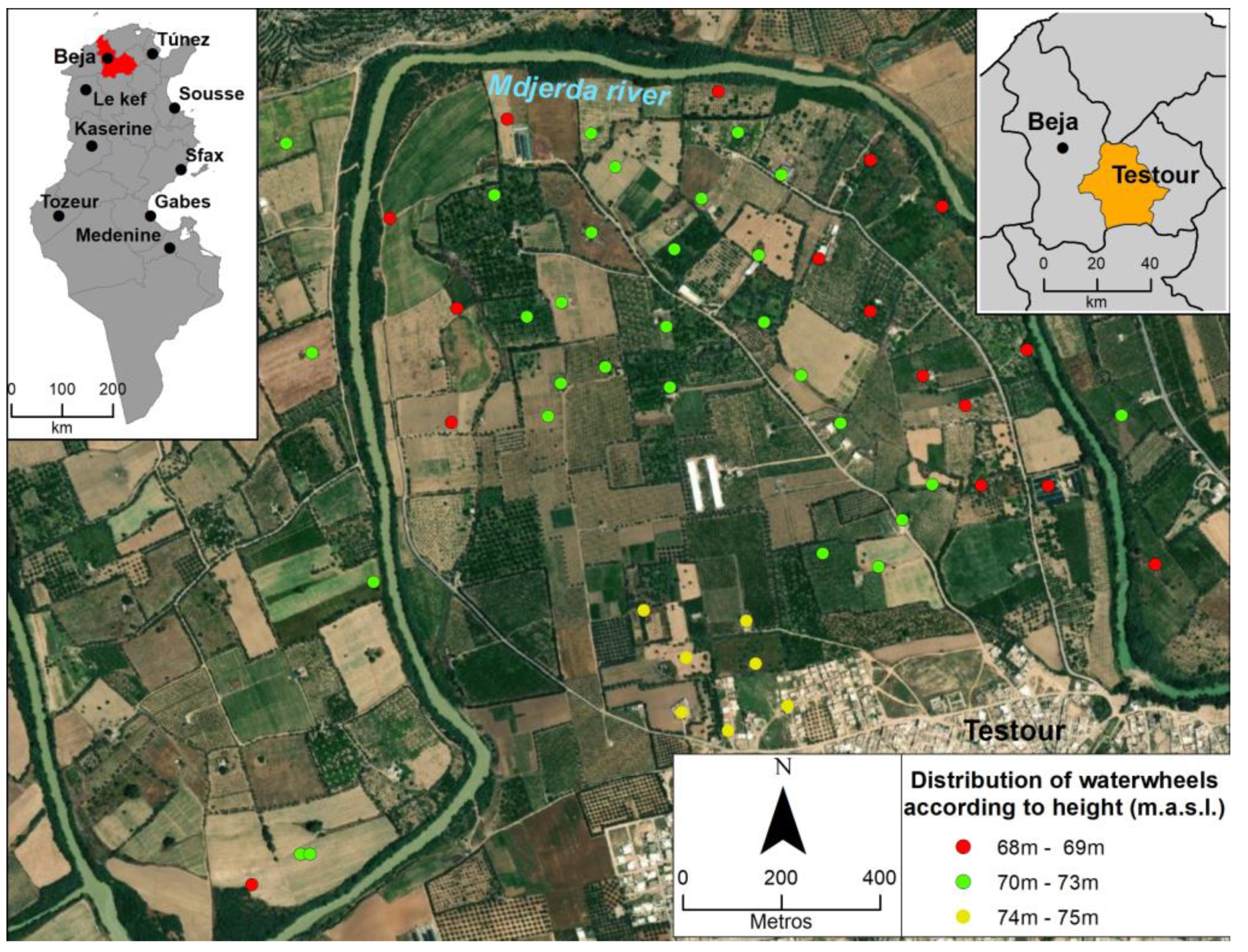
This paper makes a comparative study of animal-powered waterwheels in the Medjerda valley (Tunisia) (
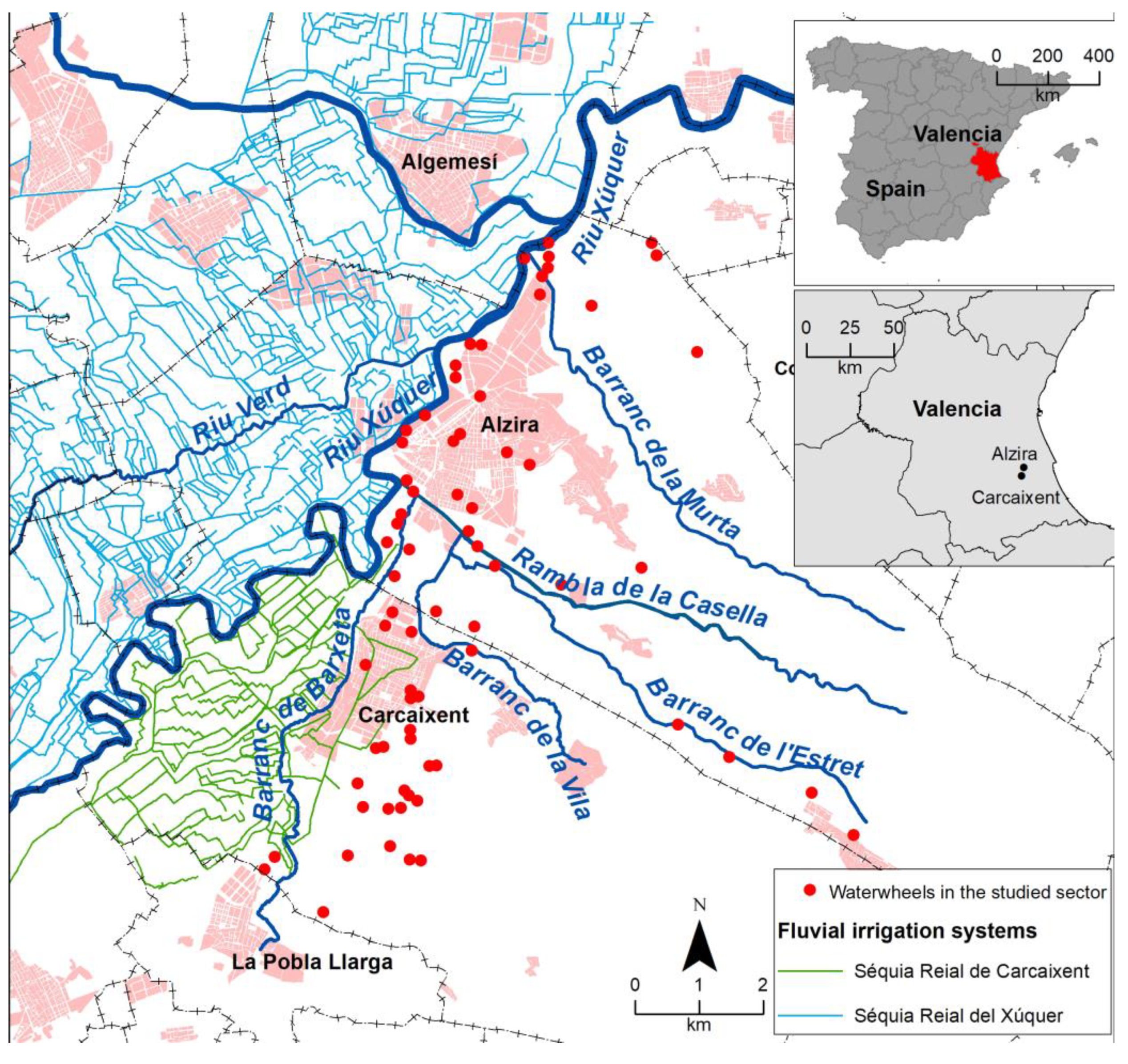
Figure 1) and in a sector of the Júcar valley (Spain) (
Figure 2). The main sector in Tunisia, in Testour (Beja Governorate), has been chosen and compared with a Spanish case in a similar environment, the alluvial plain of the Júcar between the towns of Carcaixent and Alzira (province of Valencia).
The objectives of the work are to explain the specific spatial distribution of waterwheels, compared to other traditional irrigation systems, analyse the characteristics of their elements, and explore the importance of environmental and cultural factors when using the technique. Two fluvial sectors of meandering rivers with similarly sized basins (the Medjerda and Júcar rivers) were chosen to control the environmental variable. Common elements of cultural heritage have been considered, given that Testour was one of the main resettlement enclaves for the Moorish population expelled from the Iberian Peninsula.
2. Materials and Methods
The research methodology is qualitative-analytical and based on the comparative study of groundwater catchment systems on Mediterranean alluvial plains. Firstly, two study areas with similar environmental characteristics were selected (Testour in Tunisia and Ribera Alta del Júcar in Spain). According to Maxwell [
18], the selection of cases is a key step in comparative case studies because this type of study requires designing analytical units of comparison, which means creating criteria for comparison that address variables within the cases.
In the case of Testour, the choice is justified as it is the sector with by far the largest number of waterwheels in Tunisia, due to the Moorish influence. In the case of Spain, there are several geographical areas where waterwheels are used. Therefore, the following selection criteria were used:
- -
Presence of a similar number of animal-powered waterwheels.
- -
Geomorphic fluvial environment.
- -
Meandering river.
- -
Confined valley of similar dimensions.
- -
Geological context with tectonic conditioning and diapiric substrate of plastic Triassic.
- -
Mediterranean climate with torrential autumn rains and a similar hydrological regime, including floods.
From the consideration of these criteria, the Ribera Alta del Júcar (Carcaixent-Alzira sector) has been selected for the case study in Spain.
Subsequently, a review and interpretation of maps from the beginning of the 20th century (dated 1936 in the case of Testour and 1904–1905 in Carcaixent and Alzira) and historical documents from each study area was carried out and from which an initial identification of the waterwheels was made. The historical document used in Testour was the “Croquis de bornage provisionale” of the Testour site, made by the Topographic Service of the Tunisian Government of the French Protectorate in 1936. It is drawn at a scale of 1:5000. In the case of the sector studied in the Ribera de Júcar, the historical cartography dates from 1906 and has been obtained from the planimetries conserved in the Topographic Archive of the Spanish National Geographic Institute. These are paper manuscripts produced mainly between 1870 and 1950. They are drawn at a scale of 1:25,000. The historical maps have been georeferenced in the sectors studied in Testour and Ribera Alta, and a geographical database has been created for both areas.
The database has been verified by fieldwork, which has made it possible to ascertain the state of conservation of the waterwheels and the elements associated with them. To systematise the collection of information, a data sheet model was designed, with three thematic fields: location; hydrogeomorphic environment; constructive characteristics and state of conservation. Thanks to this phase of the methodology, it was possible to improve the inventory and contextualise the waterwheels in their geomorphological environment. The information was completed by interviewing territorial agents (farmers and local technicians). These interviews were conducted in two groups: on the one hand, with the owners of the plots of land preserving the waterwheel, which were carried out during the fieldwork. On the other hand, with the members of the Association for the Safeguarding of the Town of Testour, which were carried out after the fieldwork. Walk-in interviews were on the characteristics and former uses of the waterwheels and on the process of abandonment.
The study was completed by a GIS analysis of the information collected on a current map base (DEM and orthoimage).
3. Historical Context
3.1. Testour
At the beginning of the 17th century, a large wave of Moriscos expelled from Spain (an estimated 80,000) arrived in Tunisia, as in other North African countries. The new arrivals found many Andalusians who had previously emigrated when the Reconquest began and there had been Andalusians in Tunisia since at least the 13th century. A small proportion of the newcomers settled in the medina in the capital of Tunis [
19] (p. 269), and the rest settled in various areas to the north of the country, including the Medjerda valley. [
20] (p. 166). This new population increased the country’s population by 10 to 15 percent [
19] (p. 268).
In the Medjerda valley these new arrivals founded (from south to north), Testour, Slouguia, Medjez el Bab, Grish el Ouad, Tebourba, Jdaida and Kalaat al Andalous [
21] (p. 123). The Moriscos introduced various cultural elements (including vocabulary, architecture, gastronomy, clothing, and traditions), as well as new farming techniques (including irrigation ditches, linear and more orderly planting, tree pruning, and grafting).
One of the most important hydraulic works of the period in Tunisia was El Batán (1616), a 114-metre-long dam with 20 arches, located in al-Battan, a district of the Moorish city of Tebourba. It was used both for power supply and irrigation of the surrounding land.
Waterwheels were not previously widespread in Tunisia. The highest concentration was found at Testour, although an isolated use of non-agricultural waterwheels could be found in other locations, such as at a well in Barouta [
22] (p. 183) in Kairouan, Sousse, and in the Tunis medina. Many of these supplied water to fountains and public baths (hammamat).
Testour was founded at the beginning of the 17th century on the site of the Roman city of Tichilla. The Moorish city was divided into three neighbourhoods: Andalusian, Tagarin, Hara [
23] (p. 131).
3.2. Ribera Alta
References to the use of the
noria waterwheels in the Spanish Levante region are abundant. Specific studies and references exist for many locations in the ‘Mediterranean orchard’ landscape and including: Campo de Cartagena [
15]; Cabo de Gata [
24]; Campos de Níjar [
25]; Bajo Segura [
26]; and Catalonia [
27].
In the regions of Valencian and Murcia, its use was reported in many places, including diverse geomorphic environments: alluvial piedmont, such as the Vinaroz-Benicarló plain [
16] (p. 95) and in Oliva [
28]; small intramontane valleys, such as in Xert [
29] (p. 37) and in Benassal [
30] (p. 47); marshes or marshlands, such as those of Sagunto [
31] (p. 183) and Peníscola [
31] (p. 187); and alluvial plains of large rivers, such as the Júcar and Segura. These are almost all animal-powered waterwheels, although there are also special cases of river waterwheels, such as at Casas del Río on the Cabriel [
32] (p. 136), or those of La Ñora and Alcantarilla on the Segura [
33] (p. 192) and [
34] (p. 113).
From a historical perspective, the use of animal-powered waterwheels had a long tradition in Valencian lands [
35] (p. 204), as in most irrigated Mediterranean areas. Waterwheels near the Júcar River in Ribera Alta are an example of their use in the alluvial plain of a meandering river. These have already been cited by Cavanilles in 1795, [
36] (p. 207) who observed that: ‘…the people of Carcaixént knew that orange trees thrive on sandy soils if they benefit from manure and irrigation: the nature of the fields convinced them; but they lacked water, which hid the earth in its bowels: they began to drill wells, made waterwheels, softened the arid sands with manure, and converted the wastelands into forests of Chinese orange trees and pomegranate trees…’.
Waterwheels also appear in old maps, such as that of Atanasio León in 1773, cited by Giménez [
37] (p. 270). Calatayud attributes the expansion of waterwheels in some Valencian areas to the agricultural intensification of this period and the spread of commercial crops in the 18th and part of the 19th centuries [
35] (p. 204).
Finally, the waterwheels of the Ribera Alta have also been studied from the point of view of heritage [
38], as well as artistic and historical transformation [
39].
4. Selected Study Areas
4.1. Medjerda–Testour
The analysed sector is to the north of the city of Testour (
Figure 1) and on both banks of the Medjerda River. This river is the main permanent fluvial river in Tunisia and one of the most important in the Maghreb, both in terms of the length of its course (460 km, of which 350 km are in Tunisia) and its flow. It rises in the Algerian Atlas at Souk Ahras and flows eastwards until it reaches its mouth in the Gulf of Tunis near the town of Kalaat al Andalous in the governorate of Ariana. It drains a watershed area of about 23,700 km
2 of which 16,100 km
2 is in Tunisia [
40] (p. 1278).
4.1.1. Geology and Geomorphology
The Medjerda valley is a Neogene basin of continental facies (conglomerates, sandstones, and clays), with Quaternary fill, in which Paleogene, Cretaceous, and Triassic structures outcrop with a SW–NE orientation (
Figure 3). The Triassic materials [
41,
42] are diapiric structures that began to form at the end of the Lower Cretaceous and continued throughout the Upper Cretaceous and Lower Tertiary. They form a ‘diapir area’ of structural mapping [
43] (p. 8).
The materials consist of clays, sandstones, dolomites, and gypsum, with a composition like the Germanic Triassic facies of the Spanish Levant. This composition indicates that as well as plastic diapiric materials, there are tectonic sills with a SW–NE alignment. These types of structures (tectonic sills and diapirism) are compatible [
44] (p. 144).
Figure 3.
Geological context of the study area. Drawn by the author and based on the geological map of Tunisia, 1:50,000, sheet 26, Oued-Zarga [
45].
Figure 3.
Geological context of the study area. Drawn by the author and based on the geological map of Tunisia, 1:50,000, sheet 26, Oued-Zarga [
45].
All the waterwheels in this sector are located in the recent Quaternary alluvium and on the lower terraces. According to the study of the fluvial terraces of the Medjerda by Bannour and Bonvallot [
46], based on the work of Beaudet, Maurer and Ruellan [
47], up to five levels of terraces can be distinguished: the flood terrace (5 m); the Holocene (10 to 15 m); the Recent Pleistocene (approx. 15 m); the Middle Pleistocene (25 m); and a fifth upper terrace (Old Pleistocene, up to 60 m high).
Four levels have been clearly located in the fieldwork, roughly corresponding to those of Bannour and Bonvallot: the flood plain (T0); the Holocene terrace (T1); the Upper Pleistocene terrace (T2); and a high terrace at least 30m above sea level (T3?) which seems to correspond to the fourth level described in the regional morphogenetic model of the Medjerda (
Figure 4).
4.1.2. Climate and Hydrology
The climate of Testour belongs to the Mediterranean Csa climate sector, according to the Köppen classification. The average annual temperature is 18.2 °C and the average annual rainfall is 450 mm. This type of climate is characterised by a dry and warm summer (with 6.2% of the total annual rainfall). The warmest months are July and August with monthly averages of 27.2 °C in both cases. The average temperature of the coldest month is 11 °C and corresponds to December (
Figure 5).
The natural hydrological regime of the Medjerda is marked by the Mediterranean pluviometric regime. It has a marked summer low water level and a period of high water in winter, spring, and autumn, the latter with floods caused by torrential rains (
Figure 6).
Testour is located between the Bou Salem (16,482 km
2 basin) and Medjez el Bab (21,185 km
2 basin) gauging stations. Both gauging stations show the natural regime of the river with a summer low water level, and winter and spring peaks. The average flow before the construction of the large Sidi Salem dam was 23.32 m
3/s at Bou Salem and 30.23 m
3/s at Medjez el Bab [
49] (pp. 292 and 301). This gives a specific flow rate of 1.83 L/km
2 at Bou Salem and 1.42 L/km
2 at Medjez el Bab.
The river’s flood regime peaks in October and is associated with major rainstorms in spring and autumn. At the Bou Salem gauge, the maximum flood measured reached 3180 m
3/s, and the maximum estimated without the regulation of the Nebeur reservoir (1949–1955) is about 4000 m
3/s [
47] (p. 238).
The construction and commissioning of the Sidi Salem reservoir (1981, 674.48 hm
3), some six km upstream of Testour, has caused a significant reduction in flow in the downstream valley [
50] (p. 318) and a change in the seasonal regime.
4.2. Júcar–Ribera Alta
The analysed sector is in the vicinity of Carcaixent and Alzira, in the Ribera Alta area of Valencia, on the right bank of the River Júcar (
Figure 2). This river is the main watercourse of the Valencia Region and the second most important in the Spanish Levante region, both in terms of the length of its course (497.5 km) and its flow (around 49 m
3/s). It drains a watershed area of some 21,578.5 km
2 [
51] (pp. 105 and 123). The basin size and flow parameters of the river are very similar to those of the Medjerda.
4.2.1. Geology and Geomorphology
The Ribera Alta, between Sumacàrcer and Alzira, is the first stretch of the Júcar after it leaves the mountains and begins to form a coastal alluvial plain. Overall, it is a fairly enclosed alluvial valley and is surrounded by limestone mountains.
From its confluence with the Cabriel at Cofrentes, the Júcar follows alternating Baetic (SW-NE) and Iberian (SE-NW) structural directions. The Betic tectonic stress dislocates and fractures the previous Iberian structures and enables diapiric extrusions of plastic Trias. From Cofrentes, the river first follows the Triassic extrusion of Cortes de Pallás. Once in La Ribera, it follows the Betic structural direction of the Triassic sills between La Ribera and La Costera (Xàtiva). From a geological, lithological, and structural point of view, therefore, the similarities with the Testour sector are considerable.
From Sumacàrcer, the river begins to develop an alluvial plain. In this sector, it receives all the important tributaries of its final stretch (Sellent, Albaida, and Magro) (
Figure 7). We highlight some of its features: (a) It is a confined plain in a closed valley and blocked at its outlet by the alluvial fan of the Magro. This conditions a concave profile of the alluvial plain, framed between limestone mountains and their foothills. In flood episodes, the overflowing water must necessarily return to the main river [
52] (p. 124) and [
53] (p. 126). (b) The successive alluvial blockages (Sellent, Albaida, and Magro) generate upstream sedimentation areas of low energy water, with silty and clayey sedimentation of decantation (
Figure 7). These are the best spaces for river irrigation, as they are silty hollows. (c) Sedimentation in more energetic environments produces natural mottles (natural levees) that protect the plain from second-order floods and generate yazoo channels (River Verd and River Barxeta) parallel to the main riverbed.
In the sector studied, we have all these types of sedimentary environments: The meandering river surroundings are higher areas with coarser detrital sedimentation. The Barxeta is a yazoo river valley. The vicinity to the S and SW of Alzira is a depressed settling basin. Finally, the alluvial piedmont attached to the mountains to the south, is formed by dejection cones and colluvium whose sediments are interdigitated with the fluvial sediments.
4.2.2. Climate and Hydrology
The climate of Ribera Alta is the characteristic Mediterranean climate of the ‘Provençal’ type that is typical, above all, on the northern coast of the western Mediterranean basin. It is a Csa with autumn maximums (October and November), instead of winter maximums. The average annual temperature is 17.2 °C and the average annual rainfall is 663 mm (
Figure 8). It is therefore a more humid climate than Testour, but not humid enough to be able to do without water supply systems such as waterwheels or river irrigation.
The natural hydrological regime of the Júcar is generally marked by the Mediterranean rainfall regime, but has three influences: (a) a rainfall influence in the headwater regime, with maximum monthly coefficients in the month of March; (b) a regime conditioned by the rainfall rhythm of the plateau, with spring peaks and summer lows; (c) a spike in the flow in October caused by torrential rains and floods in the lower basin (
Figure 9).
The section studied is between the Masía de Mompó (Sumacàrcer) and Huerto de Mulet (Albalat de la Ribera) gauges. They show the natural regime of the river with summer low flows and spring peaks, although with more attenuated values than those of the middle basin of the river in the Meseta (Los Frailes). The average flow at Masía de Mompó was 49.22 m
3/s between 1911 and 1984, before the construction of the Alarcón (1955) and Contreras (1974) reservoirs. This gives a specific flow of 2.75 L/s/km
2 [
51] (p. 123). However, the current flow is much lower because of a decrease in the inflow from the Júcar due to pumping from the La Mancha aquifer in Albacete.
The river’s flood regime is associated with large autumnal rainstorms, as occurs in the Medjerda. Voluminous historical floods have been recorded, such as that of Sant Carles, [
56] (p. 250). More than 80 floods have been recorded since 1270 [
57] (p. 292) and 12 major historical floods from 1406 to 1923 [
58] (p. 54). The flood regime of the Júcar is much more frequent and violent than that of the Medjerda. This generates a differential environmental element between the two sectors: the greater risk of destruction of waterwheels and river irrigation systems.
5. Results
5.1. Analysis of Animal-Powered Waterwheels in Testour
5.1.1. Location
The waterwheels in Testour are located on two large meanders of the Medjerda River, one in the town of Testour and another upstream. There are several other waterwheels, especially on the left bank of the river downstream and at the confluence of the Siliana and the Medjerda.
Figure 10 shows those marked (‘puits’) on the 1:25,000 topographic map represent approximately one-third of the existing waterwheels. Location is the result of three factors: (1) the cultural weight of the Moorish city of Testour; as well as (2) a very favourable environmental context, namely, the fluvial terraces of the Medjerda; and (3) its hydrological regime.
The waterwheel systems that we have been able to document are mainly distributed in the meander of the Medjerda at Testour, and two others upstream and downstream. The total number of waterwheels identified is 54, based on the Testour land register (scale 1:5000) drawn by the Topographical Service of the French Protectorate of the Tunisian Government in 1936. Of these, a first group of 16 waterwheels are located at different points on the first fluvial terrace ‘T1’ on both banks of the river. A second group, consisting of 31
norias (25 on the right bank and 6 on the left), is distributed in the lower parts of the second terrace ‘T2’. The remaining seven waterwheels occupy the upper part of the second terrace near Testour (
Figure 1).
The main justification for the massive use of waterwheels so close to the river course is the incision of the river. Its bed, in the section that runs in the area studied, is −3 m from the lowest terrace and −10 m from the plots that were irrigated with the highest waterwheels. The general low gradient of the Medjerda valley means that a hypothetical weir capable of carrying the water to this point would have to be very elevated to raise the water to this height. It would also have to be of a certain size to withstand the heavy floods that characterised the Medjerda before the construction of the Sidi Salem reservoir. In addition, the ditch from the weir would need several aqueducts to cross the tributaries (Khalled and Siliana).
5.1.2. Characteristics and Current Status of Waterwheel Systems in Testour
One of the characteristics of the Testour waterwheel system is that each waterwheel feeds a single plot. Some plots have two waterwheels, one at the top and one in the centre. Generally, the waterwheel is in the central part of the plot and irrigates the lower portion of land. The rest of the land is devoted to dry farming, usually olive trees.
According to oral sources, waterwheels were traditionally made of wood, with terracotta buckets for carrying the water (
Figure 11C). Most were replaced by more efficient cast-iron waterwheels imported from France.
The wells are circular, about five metres in diameter, and 15–20 m deep. The inner walls are lined with stone blocks bound together with mortar. Most of these wells are covered with two parallel semi-circular arches that leave a rectangular shaped hollow between them, where the waterwheel structure rested (
Figure 11A).
The storage ponds which accumulated the extracted flow were a main element in almost all the systems. The irrigation channels that distributed the water to the crops began at the ponds. These ponds are square or rectangular with raised walls of varying dimensions, depending on the surface area to be irrigated. They received the water through a channel about ten metres long, which started at the waterwheel and had a hole in the middle that served as a decanter (
Figure 11B). Often, next to the pond, there was a basin made of a single piece of stone, that served as a drinking trough (
Figure 11D).
The waterwheel systems in Testour were abandoned in two phases. The first and partial phase began in the 1960s with the replacement of the waterwheels by diesel engines, and these abandonments did not affect the well or the other elements of the system (reservoir, irrigation channels, etc.). The second phase was the total abandonment of many systems, motivated by the construction of the Sidi Salem reservoir and the availability of water for irrigation with modern canals that cover a large part of the region.
5.2. Analysis of the Animal-Powered Waterwheels on the Meanders of the Júcar
The waterwheels of Carcaixent and Alzira are located near meanders of the River Júcar, somewhat distant from the river in the case of Carcaixent and closer in the case of Alzira. There are also a few waterwheels far from the main valley, especially in the final stretch of the Casella and Estret ravines.
5.2.1. Location
The waterwheel systems identified (70 waterwheels) in the sector studied are distributed between the municipality of Carcaixent (28 waterwheels) and the municipality of Alzira (42 waterwheels on the right bank of the river).
According to Torres [
59], in the municipality of Carcaixent, waterwheels were practically non-existent throughout the 17th century, but increased from 7 to 93 between 1704 and 1798—and continued to increase in number until reaching 142 in 1833. In the historical maps of Atanasio León, dated 1773 [
60] (p. 169), we can see the location of the first waterwheels on unirrigated lands.
The analysis shows that the location of these waterwheels was not arbitrary (
Figure 2) and reflected the network of irrigation ditches. In both municipalities, river irrigation does not reach the high ground of the foothills of the adjoining sierras. In Carcaixent, the location of the waterwheels is exclusively in the lower foothills between the right bank of the Barxeta river and the mountains. In Alzira, there are waterwheels in the lower part of the ravine of l’Estret (in the area of the Casella, Estret, and La Vila ravines), in the lower part of the ravine of Murta dejection cone, and on the right bank of the Júcar, next to the town of Alzira.
Thus, the environmental conditions of these
norias differ from those of the irrigation ditches. The latter are in the fluvial environment of the flood basin, according to Ruiz Pérez [
54] (map on p. 36), while the more elevated
norias are on the Plio-Pleistocene piedmont on the margins of the flood plain. The reason may be twofold: firstly, these are areas beyond the reach of the irrigation channels; and secondly, installation on the piedmont avoided exposing delicate and valuable waterwheels to the frequent violent floods on the flood plain.
5.2.2. Characteristics and Current Situation
Unlike the waterwheels in Testour, some of those in La Ribera could supply more than one field. The name of these installations usually coincided with the name of the owner’s family (such as Casa de Bautista, Casa Noguera, and Casa de Florencio). A practical element in these systems was the storage pond (
Figure 12C). Most of which continue to store water, but using other methods to raise the water (
Figure 12A). All the ponds identified in the fieldwork have a square shape (with a length of between 8 and 11 m) (
Figure 13B), and thick raised walls. Some have a striking feature, which is a washing slab fixed to the side closest to the dwelling. However, according to the historical map of 1906, 25% of the waterwheels in Carcaixent lacked a pond.
The wells were rectangular (
Figure 12D) and positioned in the central part of a raised circular platform (
Figure 12B), where the draught animal circulated, with an access ladder or ramp. Inside, crossbeams can be seen (
Figure 13A) that separated the lowering side of the buckets from the opposite side.
The first waterwheels were made of wood, which greatly limited the extraction capacity and often required maintenance and repairs. Roldán [
61] (p. 56) points out that the depth of the phreatic water in medieval waterwheels was less than 10 m. Even so, these devices were responsible for the initial expansion of irrigation until the mid-19th century, when the first cast-iron waterwheels appeared. Despite these technical improvements, the expansion of irrigation was limited to areas with shallow water tables. These limitations were overcome [
39] (p. 47) with the use of steam-powered water-lifting pumps (see
Figure 13B).
6. Discussion and Conclusions
The wide meanders of the Medjerda are compared with the alluvial plain of a meandering river with very similar characteristics, the Júcar. Both rivers are equivalent in terms of the size of their watershed, alpine geological context, average rainfall, flow rates, flood regime (to a lesser extent), and even in detailed hydrogeomorphic aspects (such as width of the alluvial plain, slope, meandering character of the main river, existence of protected areas outside the flood plain, and surface aquifers.). Given such similar conditions, the null hypothesis was that there would be no substantial differences in the characteristics and use of waterwheels, and the alternative was that, if differences were found, then they were due to non-environmental factors.
From the comparative analysis carried out, it can be deduced that there are no significant differences in the use of these systems in the two locations. We see the same basic technique (animal-powered waterwheels), with the same technological evolution (wheel buckets, wood, iron, and motors), with similar spatial densities (basically used by individual families), similar relative incompatibility with fluvial irrigation systems, and even similar protections from floods. However, a common cultural origin means it is difficult to attribute the similarities solely to environmental factors.
The use of the animal-powered waterwheels for water elevation was not the first option for traditional irrigation in the market gardens of the Ribera Alta del Júcar, given their high economic cost and limitations for the irrigation of large areas. In the meanders of the river Medjerda, to the north of Testour, they were the first irrigation system due to the difficulties presented by the layout of the river system and the small size of the potentially irrigable land. In both cases, they are complementary systems.
The cultural weight of this technique is clearly visible and identical in both places studied. However, the key factor in the use of waterwheels continues to be the physical environment. Above all, hydrogeological and geomorphological components have been the main determining factors in their location. Both in Testour and in Ribera Alta, they were protected from large river floods by being located at the optimum point where the water table is high (which means that they are fairly close to the river) and where the risk of flooding is minimal (which means that they are located a certain distance from the river).
In both places, the waterwheels are now abandoned or adapted with engines to continue irrigation. This is a similar transformation or abandonment in almost identical environments (the meanders of the Medjerda and the Júcar) which have remained largely unchanged despite the use of this water extraction technique.
The difficulty of attributing these similarities exclusively to environmental factors, due to the common cultural origin, leads us to propose, as future lines of research, the exploration of several aspects: (i) in the comparative analysis with other areas where this irrigation technique has been used, (ii) in the environmental contexts, especially the hydrogeological ones (despite the difficulty derived from the deterioration and abandonment of the systems), (iii) in the analysis of the ethnological aspects (in the cases where this irrigation system is maintained) or historical aspects.


