


Identification and Hierarchy of Traditional Village Characteristics Based on Concentrated Contiguous Development—Taking 206 Traditional Villages in Hubei Province as an Example

Abstract
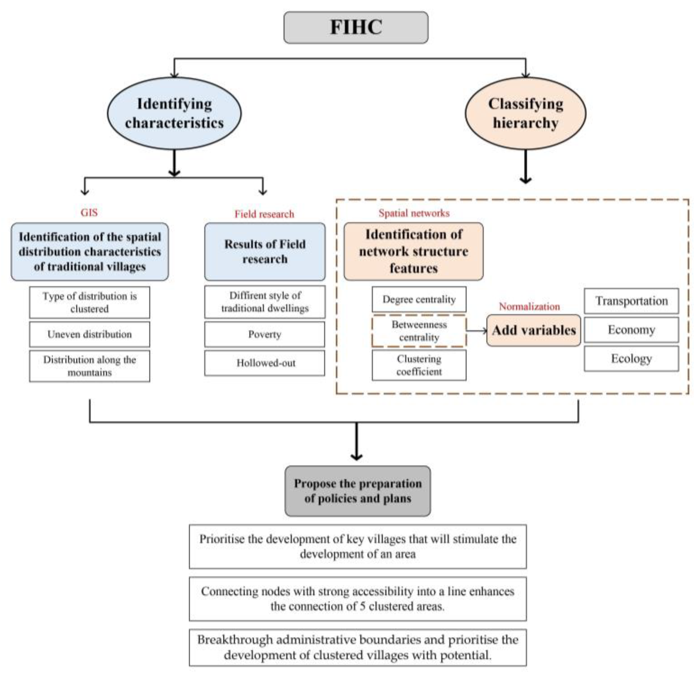
:1. Introduction
2. Materials and Methods
2.1. Study Area
2.2. Data Sources and Processing
2.3. Methods
2.3.1. Geospatial Analysis Method
- The Nearest Neighbour Index
- 2.
- Kernel Density Estimation
2.3.2. Methods of Spatial Networks
- Methods for Constructing Networks
- (1)
- Voronoi
- (2)
- Delaunay Triangulation
- 3.
- Spatial Networks Indicators
3. Results and Analysis
3.1. Geospatial Distribution Characteristics of Traditional Villages in Hubei Province
3.1.1. The Distribution Type of 206 Traditional Villages Is Clustered
3.1.2. Traditional Villages Are Extremely Unevenly Distributed
3.1.3. Distribution of Traditional Villages along Mountain Ranges
3.1.4. One of the Most Basic Principles in Choosing a Residential Site Is “By the Mountain and the Water”
3.2. Spatial Network Characteristics of Traditional Villages in Hubei
3.2.1. Original Spatial Network Results
- Low Connectivity of Villages
- 2.
- Poor Accessibility in Traditional Villages
- 3.
- High Extent of Clustering in Traditional Villages
3.2.2. Adjusted Spatial Network Characteristics
- Traditional Villages have poor Accessibility
- 2.
- Traditional Villages have a poor Economic Condition
- 3.
- The Ecological Conditions of Traditional Villages in Hubei Province are Good
3.3. Field Research Results
- Traditional Dwellings have Different Styles
- 2.
- Traditional Villages have sound Ecology
- 3.
- Traditional Villages are Seriously Hollowed Out and Lack Vitality
- 4.
- The Imbalance Between Conservation and Development
4. Discussion
4.1. Obstacles to Revitalizing Traditional Villages in Hubei
4.1.1. Limited Development Funding and Over-Reliance on Government
4.1.2. Mountainous Terrain and Poor Transportation Hindered the Development of the Village with the Outside World
4.2. Strengths of FIHC Framework in Rural Revitalisation
4.2.1. The FIHC Helps Make Policymakers Implement the Work of Concentrated and Continuous Demonstration Counties
4.2.2. The FIHC Helps Village Builders Implement “Hierarchical and Key Nodes” of Traditional Village Planning
4.3. Policy Suggestions
4.3.1. Prioritise the Development of Key Villages That Will Stimulate the Development of an Area
4.3.2. Connecting Villages with Strong Accessibility into a Line Enhances the Connection of 5 Clustered Areas
4.4. Contributions to Research, Limitations and Future Work
5. Conclusions
Author Contributions
Funding
Institutional Review Board Statement
Informed Consent Statement
Data Availability Statement
Acknowledgments
Conflicts of Interest
References
- Riney-Kehrberg, P. Survival of Rural America: Small Victories and Bitter Harvests. West. Hist. Q. 2009, 40, 230–231. [Google Scholar] [CrossRef]
- Onitsuka, K.; Hoshino, S. Inter-community networks of rural leaders and key people: Case study on a rural revitalization program in Kyoto Prefecture, Japan. J. Rural Stud. 2018, 61, 123–136. [Google Scholar] [CrossRef]
- Li, Y.; Westlund, H.; Zheng, X.; Liu, Y. Bottom-up initiatives and revival in the face of rural decline: Case studies from China and Sweden. J. Rural Stud. 2016, 47, 506–513. [Google Scholar] [CrossRef]
- Hedlund, M.; Lundholm, E. Restructuring of rural Sweden—Employment transition and out-migration of three cohorts born 1945–1980. J. Rural Stud. 2015, 42, 123–132. [Google Scholar] [CrossRef]
- Phillips, M.; Page, S.; Saratsi, E.; Tansey, K.; Moore, K. Diversity, scale and green landscapes in the gentrification process: Traversing ecological and social science perspectives. Appl. Geogr. 2008, 28, 54–76. [Google Scholar] [CrossRef]
- Nelson, P.B.; Oberg, A.; Nelson, L. Rural gentrification and linked migration in the United States. J. Rural Stud. 2010, 26, 343–352. [Google Scholar] [CrossRef]
- Long, H.; Zhang, Y.; Tu, S. Land consolidation and rural vitalization. Acta Geogr. Sin. 2018, 73, 1837–1849. [Google Scholar]
- Pierskalla, J.H. The Politics of Urban Bias: Rural Threats and the Dual Dilemma of Political Survival. Stud. Comp. Int. Dev. 2016, 51, 286–307. [Google Scholar] [CrossRef]
- Li, Y.; Wu, W.; Liu, Y. Land consolidation for rural sustainability in China: Practical reflections and policy implications. Land Use Policy 2018, 74, 137–141. [Google Scholar] [CrossRef]
- Long, H.; Tu, S.; Ge, D.; Li, T.; Liu, Y. The allocation and management of critical resources in rural China under restructuring: Problems and prospects. J. Rural Stud. 2016, 47, 392–412. [Google Scholar] [CrossRef]
- Bai, X.; Shi, P.; Liu, Y. Realizing China’s urban dream. Nature 2014, 509, 158–160. [Google Scholar] [CrossRef] [Green Version]
- Wang, Y.; Liu, Y.; Li, Y.; Li, T. The spatio-temporal patterns of urban–rural development transformation in China since 1990. Habitat Int. 2016, 53, 178–187. [Google Scholar] [CrossRef]
- Chen, C.; Woods, M.; Chen, J.; Liu, Y.; Gao, J. Globalization, state intervention, local action and rural locality reconstitution—A case study from rural China. Habitat Int. 2019, 93, 102052. [Google Scholar] [CrossRef]
- Sun, D.; Zhou, L.; Li, Y.; Liu, H.; Shen, X.; Wang, Z.; Wang, X. New-type urbanization in China: Predicted trends and investment demand for 2015–2030. J. Geogr. Sci. 2017, 27, 943–966. [Google Scholar] [CrossRef]
- Liu, Y.; Yang, R.; Li, Y. Potential of land consolidation of hollowed villages under different urbanization scenarios in China. J. Geogr. Sci. 2013, 23, 503–512. (In Chinese) [Google Scholar] [CrossRef]
- Li, Y.; Yan, J.; Song, C. Rural revitalization and sustainable development: Typical case analysis and its enlightenments. Geogr. Res. 2019, 38, 595–604. [Google Scholar]
- Liu, J.; Zhang, X.; Lin, J.; Li, Y. Beyond government-led or community-based: Exploring the governance structure and operating models for reconstructing China’s hollowed villages. J. Rural Stud. 2022, 93, 273–286. [Google Scholar] [CrossRef]
- Liu, Y.-S.; Liu, Y.; Chen, Y.; Long, H. The process and driving forces of rural hollowing in China under rapid urbanization. J. Geogr. Sci. 2010, 20, 876–888. [Google Scholar] [CrossRef]
- Liu, Q.; Liao, Z.; Wu, Y.; Degefu, D.M.; Zhang, Y. Cultural Sustainability and Vitality of Chinese Vernacular Architecture: A Pedigree for the Spatial Art of Traditional Villages in Jiangnan Region. Sustainability 2019, 11, 6898. [Google Scholar] [CrossRef]
- Zhang, X. Impact of rural tourism on residents’ well-being in traditional ancient villages: A case of North Guangxi. Heritage Sci. 2021, 9, 138. [Google Scholar] [CrossRef]
- Li, Y.; Liu, Y.; Long, H.; Cui, W. Community-based rural residential land consolidation and allocation can help to revitalize hollowed villages in traditional agricultural areas of China: Evidence from Dancheng County, Henan Province. Land Use Policy 2014, 39, 188–198. [Google Scholar] [CrossRef]
- Wang, D.; Zhu, Y.; Zhao, M.; Lv, Q. Multi-dimensional hollowing characteristics of traditional villages and its influence mechanism based on the micro-scale: A case study of Dongcun Village in Suzhou, China. Land Use Policy 2021, 101, 105146. [Google Scholar] [CrossRef]
- Ye, J. Stayers in China’s “hollowed-out” villages: A counter narrative on massive rural-urban migration. Popul. Space Place 2018, 24, e2128. [Google Scholar] [CrossRef]
- Xi, J. Secure a Decisive Victory in Building a Moderately Prosperous Society in All Respects and Strive for the Great Success of Socialism with Chinese Characteristics for a New Era. In Proceedings of the 19th National Congress of the Communist Party of China, Beijing, China, 18–24 October 2017. [Google Scholar]
- Li, Y.; Qiao, L.; Wang, Q.; Karácsonyi, D. Towards the evaluation of rural livability in China: Theoretical framework and empirical case study. Habitat Int. 2020, 105, 102241. [Google Scholar] [CrossRef]
- Xi, J.; Wang, X.; Kong, Q.; Zhang, N. Spatial Morphology Evolution of Rural Settlements Induced by Tourism: A Comparative Study of Three Villages in Yesanpo Tourism Area, China. J. Geogr. Sci. 2015, 25, 497–511. [Google Scholar] [CrossRef]
- Meng, Q.; Wang, C.; Xu, T.; Pi, H.; Wei, Y. Evaluation of the Sustainable Development of Traditional Ethnic Village Tourist Destinations: A Case Study of Jiaju Tibetan Village in Danba County, China. Land 2022, 11, 1008. [Google Scholar] [CrossRef]
- Jiang, Z.; Sun, Y. Exploring the Spatial Image of Traditional Villages from the Tourists’ Hand-Drawn Sketches. Sustainability 2022, 14, 5977. [Google Scholar] [CrossRef]
- Gao, J.; Wu, B. Revitalizing traditional villages through rural tourism: A case study of Yuanjia Village, Shaanxi Province, China. Tour. Manag. 2017, 63, 223–233. [Google Scholar] [CrossRef]
- Xu, J.; Yang, M.; Hou, C.; Lu, Z.; Liu, D. Distribution of rural tourism development in geographical space: A case study of 323 traditional villages in Shaanxi, China. Eur. J. Remote Sens. 2021, 54, 318–333. [Google Scholar] [CrossRef]
- Fu, J.; Zhou, J.; Deng, Y. Heritage values of ancient vernacular residences in traditional villages in Western Hunan, China: Spatial patterns and influencing factors. Build. Environ. 2021, 188, 107473. [Google Scholar] [CrossRef]
- Cao, Y.; Li, G.; Wang, J.; Fang, X.; Zhou, L.; Liu, Y. Distinct types of restructuring scenarios for rural settlements in a heterogeneous rural landscape: Application of a clustering approach and ecological niche modeling. Habitat Int. 2020, 104, 102248. [Google Scholar] [CrossRef]
- Kong, X.; Liu, D.; Tian, Y.; Liu, Y. Multi-objective spatial reconstruction of rural settlements considering intervillage social connections. J. Rural Stud. 2021, 84, 254–264. [Google Scholar] [CrossRef]
- Lu, M.; Wei, L.; Ge, D.; Sun, D.; Zhang, Z.; Lu, Y. Spatial optimization of rural settlements based on the perspective of appropriateness–domination: A case of Xinyi City. Habitat Int. 2020, 98, 102148. [Google Scholar] [CrossRef]
- Liu, X.; Li, Y.; Wu, Y.; Li, C. The Spatial Pedigree in Traditional Villages under the Perspective of Urban Regeneration—Taking 728 Villages in Jiangnan Region, China as Cases. Land 2022, 11, 1561. [Google Scholar] [CrossRef]
- Song, W.; Li, H. Spatial pattern evolution of rural settlements from 1961 to 2030 in Tongzhou District, China. Land Use Policy 2020, 99, 105044. [Google Scholar] [CrossRef]
- Li, H.; Song, W. Pattern of spatial evolution of rural settlements in the Jizhou District of China during 1962–2030. Appl. Geogr. 2020, 122, 102247. [Google Scholar] [CrossRef]
- Li, Z. The Spatial-Temporal Evolution and Formation Mechanism of Ancient Village in Fenhe River Basin. Econ. Geogr. 2019, 39, 207–214+231. [Google Scholar] [CrossRef]
- Nguyen, V.T.A.; Park, J.-H.; Jeon, Y. The Spatial and Environmental Characteristics of Vietnamese Vernacular Houses in Vietnam’s French Colonial Public Buildings. Open House Int. 2022, 47, 122–134. [Google Scholar] [CrossRef]
- Pei, Y.; Gong, K.; Leng, J. Study on the inter-village space of a traditional village group in Huizhou Region: Hongguan Village group as an example. Front. Arch. Res. 2020, 9, 588–605. [Google Scholar] [CrossRef]
- Lu, S.; Li, G.; Xu, M. The linguistic landscape in rural destinations: A case study of Hongcun Village in China. Tour. Manag. 2020, 77, 104005. [Google Scholar] [CrossRef]
- Xu, J.; Song, J.; Li, B.; Liu, D.; Wei, D.; Cao, X. Do settlements isolation and land use changes affect poverty? Evidence from a mountainous province of China. J. Rural Stud. 2020, 76, 163–172. [Google Scholar] [CrossRef]
- Chen, J.; Wang, C.; Dai, R.; Xu, S.; Shen, Y.; Ji, M. Practical Village Planning Strategy of Different Types of Villages—A Case Study of 38 Villages in Shapingba District, Chongqing. Land 2021, 10, 1143. [Google Scholar] [CrossRef]
- Su, H.; Wang, Y.; Zhang, Z.; Dong, W. Characteristics and Influencing Factors of Traditional Village Distribution in China. Land 2022, 11, 1631. [Google Scholar] [CrossRef]
- Shih, H.-Y. Network characteristics of drive tourism destinations: An application of network analysis in tourism. Tour. Manag. 2006, 27, 1029–1039. [Google Scholar] [CrossRef]
- Barthélemy, M. Spatial networks. Phys. Rep. 2011, 499, 1–101. [Google Scholar] [CrossRef]
- Barabási, A.-L. Scale-Free Networks: A Decade and Beyond. Science 2009, 325, 412–413. [Google Scholar] [CrossRef]
- Lee, S.-H.; Choi, J.-Y.; Yoo, S.-H.; Oh, Y.-G. Evaluating Spatial Centrality for Integrated Tourism Management in Rural Areas Using GIS and Network Analysis. Tour. Manag. 2013, 34, 14–24. [Google Scholar] [CrossRef]
- Yi, J.; Ryan, C.; Wang, D. China’s Village Tourism Committees: A Social Network Analysis. J. Travel Res. 2021, 60, 117–132. [Google Scholar] [CrossRef]
- Zhou, J.; Hou, Q. Resilience assessment and planning of suburban rural settlements based on complex network. Sustain. Prod. Consum. 2021, 28, 1645–1662. [Google Scholar] [CrossRef]
- Chen, X.; Xie, W.; Li, H. The spatial evolution process, characteristics and driving factors of traditional villages from the perspective of the cultural ecosystem: A case study of Chengkan Village. Habitat Int. 2020, 104, 102250. [Google Scholar] [CrossRef]
- King, T.L.; Bentley, R.J.; Thornton, L.E.; Kavanagh, A.M. Using kernel density estimation to understand the influence of neighbourhood destinations on BMI. BMJ Open 2016, 6, e008878. [Google Scholar] [CrossRef] [PubMed]
- Xiong, Y.; Wang, H. Spatial relationships between NDVI and topographic factors at multiple scales in a watershed of the Minjiang River, China. Ecol. Inform. 2022, 69, 101617. [Google Scholar] [CrossRef]
- Degenne, A. Forse Introducing Social Networks; Sage Publications: London, UK, 1999. [Google Scholar]
- Ye, Q.; Li, J.; Kong, X.; Zhang, S. Identification and Optimization of the Spatial Structure of Urban and Rural Settlements from a Hierarchical Network Perspective. Land 2021, 10, 1177. [Google Scholar] [CrossRef]
- Wei, D.; Wang, Z.; Zhang, B. Traditional Village Landscape Integration Based on Social Network Analysis: A Case Study of the Yuan River Basin in South-Western China. Sustainability 2021, 13, 13319. [Google Scholar] [CrossRef]
- Liu, C.; Xu, M. Characteristics and Influencing Factors on the Hollowing of Traditional Villages—Taking 2645 Villages from the Chinese Traditional Village Catalogue (Batch 5) as an Example. Int. J. Environ. Res. Public Health 2021, 18, 12759. [Google Scholar] [CrossRef]
- Yu, R.; Chen, H.; Chen, G.; Liu, C. Spatial Distribution of Rural Tourism Destination and Influencing Factors in Hubei Province—A Case Study of High-Star Agritainment. Econ. Geogr. 2018, 38, 210–217. [Google Scholar]
- Qiao, H.; Wu, Y.; Feng, J.; Zeng, J.; Liu, D. The Development Evaluation and Police Choice of Tourism Industry in Hubei Province. Econ. Geogr. 2017, 37, 212–218. [Google Scholar]
- Tian, Y.; Wang, Z.; Zhao, J.; Jiang, X.; Guo, R. A Geographical Analysis of the Poverty Causes in China’s Contiguous Destitute Areas. Sustainability 2018, 10, 1895. [Google Scholar] [CrossRef]
- Ji, W. An Influence of Chinese Traditional Geomantic Concept on Layout of Settlements in Huizhou—With an example of the Pingshan Village. In Advanced Building Materials and Sustainable Architecture; Shao, Y., Hao, S., Luo, Y., Xing, J., Liu, Z., Eds.; Trans Tech Publications Ltd.: Stäfa, Switzerland, 2012; Volume 174–177, pp. 1849–1854. [Google Scholar]
- Qu, Y.; Zhao, W.; Zhao, L.; Zheng, Y.; Xu, Z.; Jiang, H. Research on Hollow Village Governance Based on Action Network: Mode, Mechanism and Countermeasures—Comparison of Different Patterns in Plain Agricultural Areas of China. Land 2022, 11, 792. [Google Scholar] [CrossRef]
- Tang, Y. Discrete Dynamic Modeling Analysis of Rural Revitalization and Ecotourism Sustainable Prediction Based on Big Data. Discret. Dyn. Nat. Soc. 2022, 2022, 9158905. [Google Scholar] [CrossRef]
- Liu, S.; Ge, J.; Bai, M.; Yao, M.; He, L.; Chen, M. Toward classification-based sustainable revitalization: Assessing the vitality of traditional villages. Land Use Policy 2022, 116, 106060. [Google Scholar] [CrossRef]
- Zhou, Z.; Zheng, X. A Cultural Route Perspective on Rural Revitalization of Traditional Villages: A Case Study from Chishui, China. Sustainability 2022, 14, 2468. [Google Scholar] [CrossRef]
- Zhang, Q.; Kim, E.; Yang, C.; Cao, F. Rural revitalization: Sustainable strategy for the development of cultural landscape of traditional villages through optimized IPA approach. J. Cult. Heritage Manag. Sustain. Dev. 2021, 13, 66–86. [Google Scholar] [CrossRef]


| No. | City and State Name | Number |
|---|---|---|
| 1 | Enshi Tujia and Miao Autonomous Prefecture | 81 |
| 2 | Huanggang | 36 |
| 3 | Xianning | 21 |
| 4 | Huangshi | 13 |
| 5 | Shiyan | 13 |
| 6 | Yichang | 12 |
| 7 | Xiaogan | 11 |
| 8 | Xiangyang | 6 |
| 9 | Suizhou | 4 |
| 10 | Wuhan | 4 |
| 11 | Jingmen | 3 |
| 12 | Jingzhou | 1 |
| 13 | Xiantao | 1 |
| 14 | Ezhou | 0 |
| 15 | Tianmen | 0 |
| 16 | Shennongjia Forestry District | 0 |
| 17 | Qianjiang | 0 |
| Name | Equation | Equation Interpretation | No. |
|---|---|---|---|
| Radiance Formula of Luojia No. 1 | Where L is the absolute radiation correction after the radiation brightness value. The unit is , DN is the grey value of images. | (4) | |
| NDVI Vegetation Index | Where band5 and band4 refer to the spectral reflectance in the near-infrared and red bands, respectively [53]. | (5) | |
| Normalised Equation | Where the normalised equation performs a linear operator of the raw data to achieve an isometric scaling of the original data. The different kinds of data are grouped into one dimension. X is the original data. | (6) |
| Name | Formula | Formula Interpretation | No. |
|---|---|---|---|
| Degree centrality (DC) | CDc is the degree of centrality of a single village, i represents the ith traditional village node within the network, n is the total number of traditional villages. xij is the degree of connectivity between the ith and the other village [55]. | (7) | |
| Betweenness centrality (BC) | CBC is the intermediary centrality of a single rural area. dij denotes the number of shortest paths from i to o. Dio (n) is the number of nodes that pass through in the shortest path from i to o. | (8) | |
| Clustering coefficient centrality (CC) | Li denotes the number of links between the ki neighbours of node i. The higher the degree of connectivity between nodes, the more conducive to forming a stable network structure [45,46]. | (9) |
| Class | Number of Nodes with Original betweenness Centrality | Number of Nodes with Added Weights | ||
|---|---|---|---|---|
| Road | Light | NDVI | ||
| Strong | 6 | 10 | 10 | 19 |
| Medium | 17 | 10 | 31 | 76 |
| Weak | 183 | 186 | 165 | 111 |
Disclaimer/Publisher’s Note: The statements, opinions and data contained in all publications are solely those of the individual author(s) and contributor(s) and not of MDPI and/or the editor(s). MDPI and/or the editor(s) disclaim responsibility for any injury to people or property resulting from any ideas, methods, instructions or products referred to in the content. |
© 2023 by the authors. Licensee MDPI, Basel, Switzerland. This article is an open access article distributed under the terms and conditions of the Creative Commons Attribution (CC BY) license (https://creativecommons.org/licenses/by/4.0/).
Share and Cite
Liu, X.; Yuan, L.; Tan, G. Identification and Hierarchy of Traditional Village Characteristics Based on Concentrated Contiguous Development—Taking 206 Traditional Villages in Hubei Province as an Example. Land 2023, 12, 471. https://doi.org/10.3390/land12020471
Liu X, Yuan L, Tan G. Identification and Hierarchy of Traditional Village Characteristics Based on Concentrated Contiguous Development—Taking 206 Traditional Villages in Hubei Province as an Example. Land. 2023; 12(2):471. https://doi.org/10.3390/land12020471
Chicago/Turabian StyleLiu, Xiaohu, Lei Yuan, and Gangyi Tan. 2023. "Identification and Hierarchy of Traditional Village Characteristics Based on Concentrated Contiguous Development—Taking 206 Traditional Villages in Hubei Province as an Example" Land 12, no. 2: 471. https://doi.org/10.3390/land12020471