
Urban Intensity in Theory and Practice: Empirical Determining Mechanism of Floor Area Ratio and Its Deviation from the Classic Location Theories in Beijing


Abstract
:1. Introduction
2. Literature Review
3. Methodology
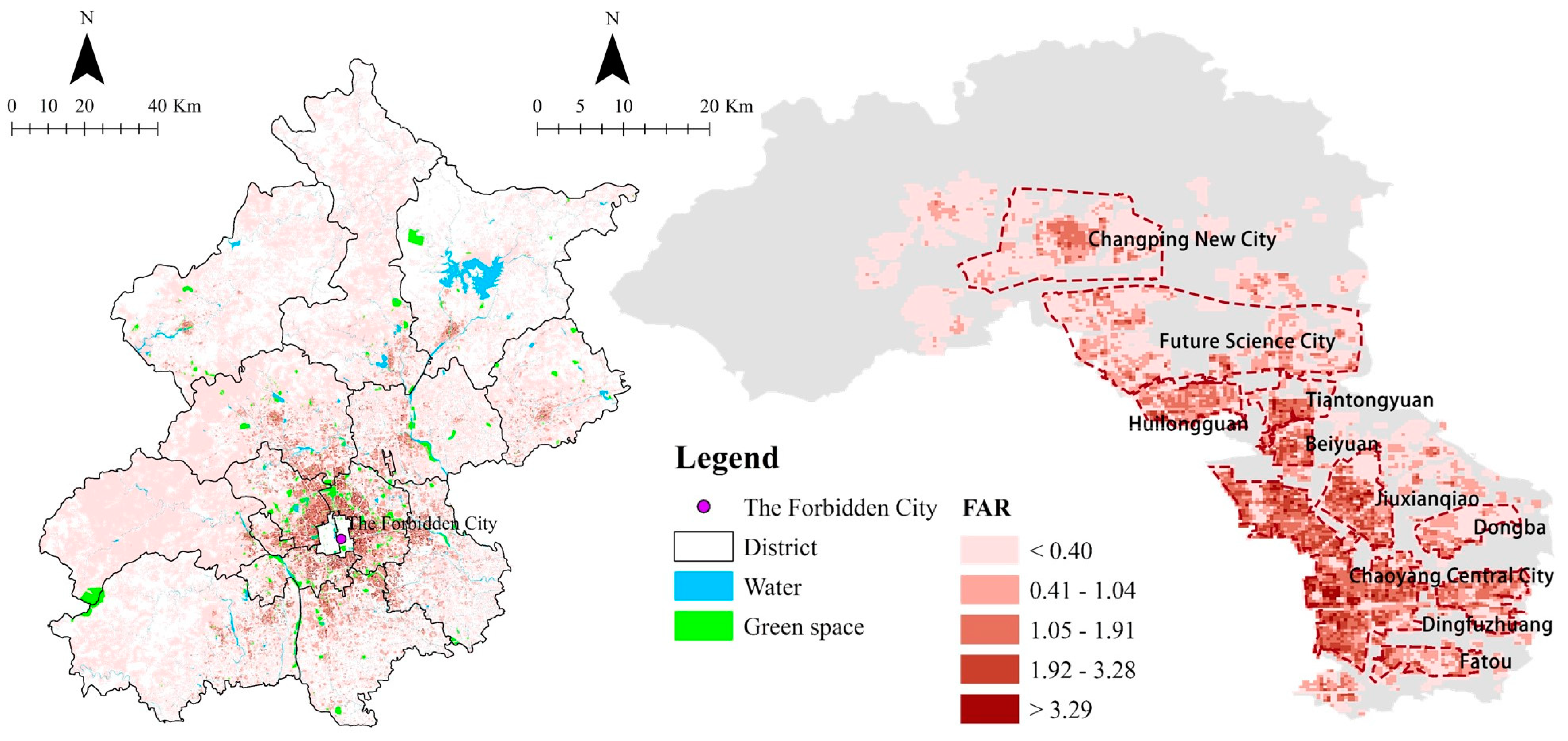
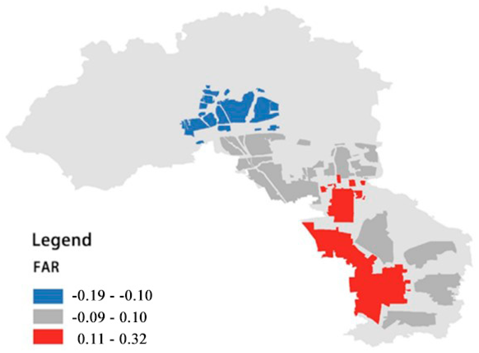
3.1. Study Area
3.2. Empirical Modeling of the Formulation Mechanism of Urban Intensity
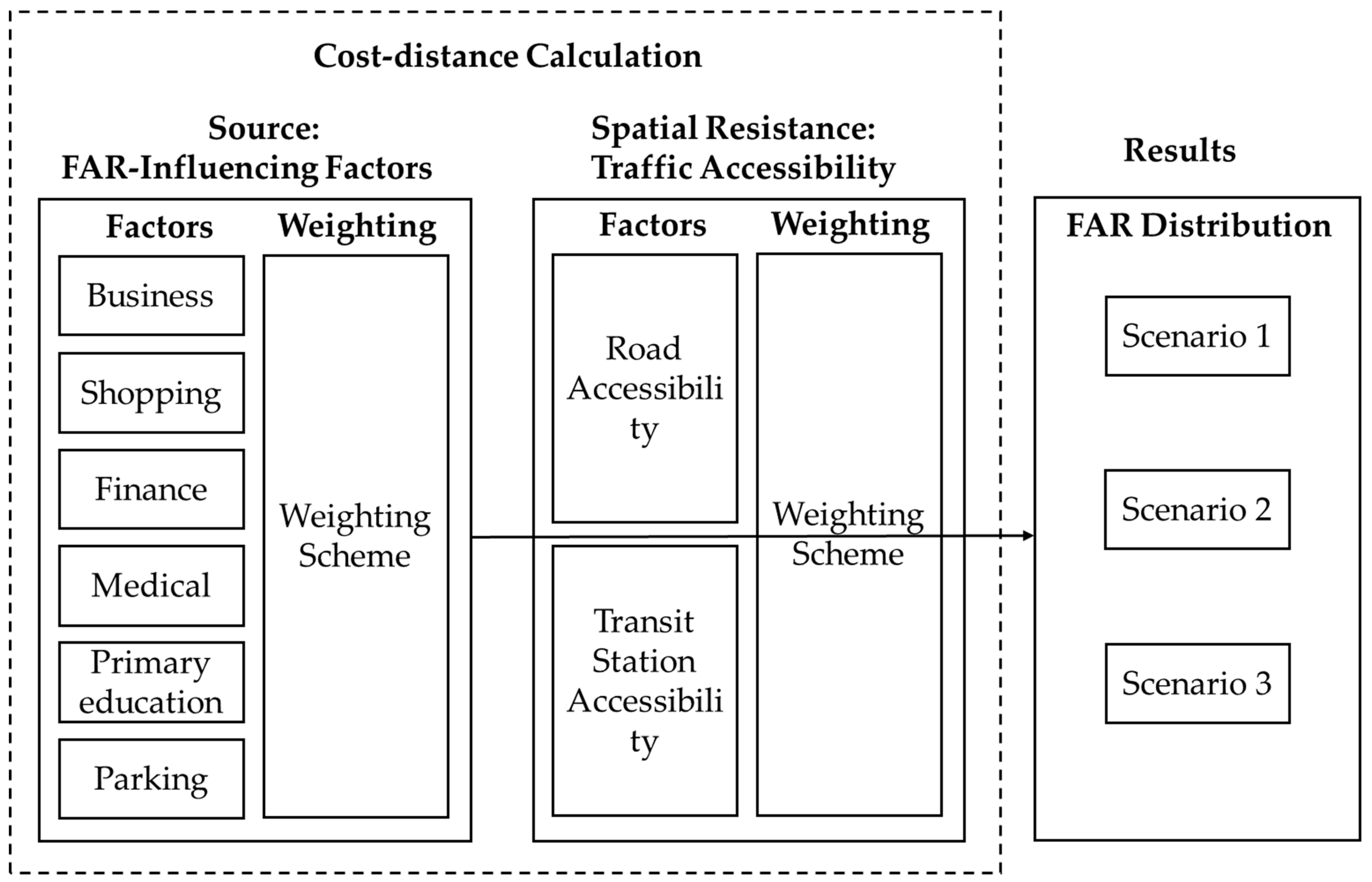
3.3. “Ideal” Urban Intensity Modeling
3.4. Data
4. Results
4.1. Empirical Models
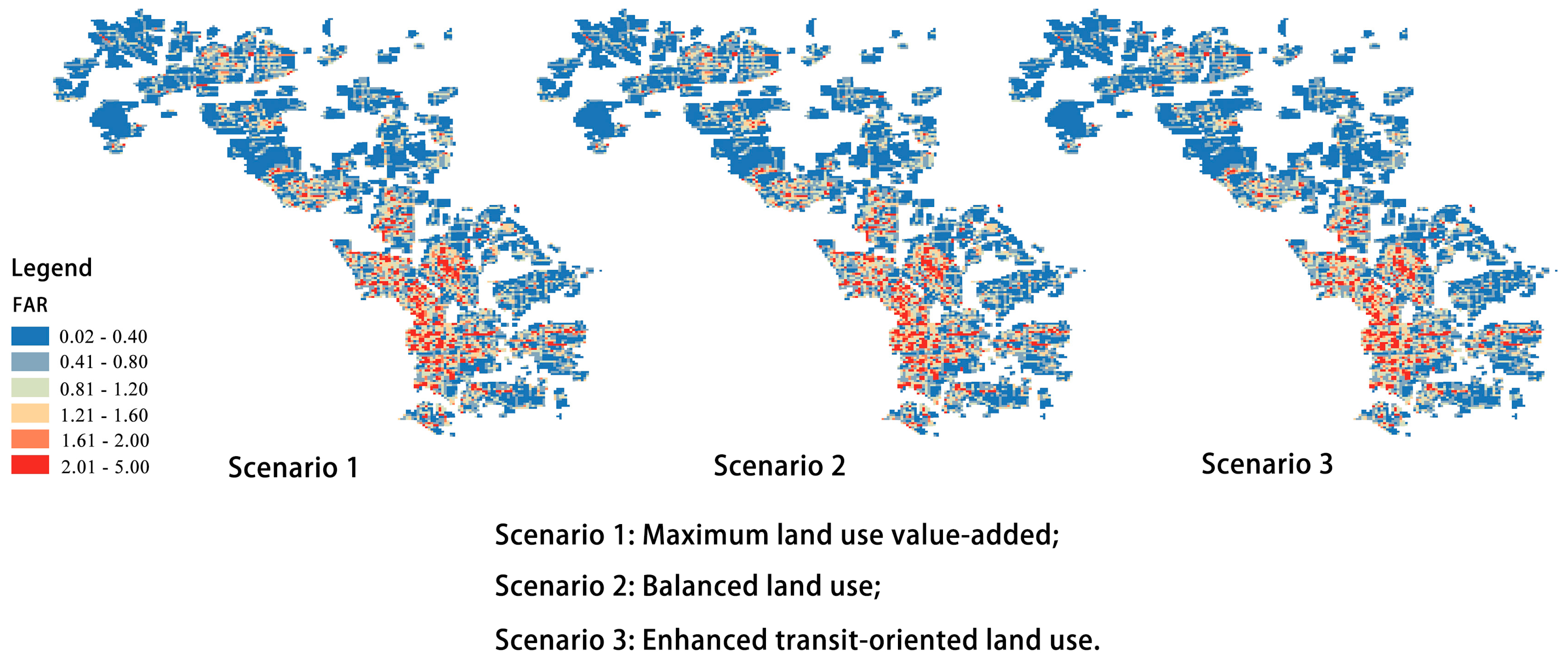
4.2. “Ideal” Models
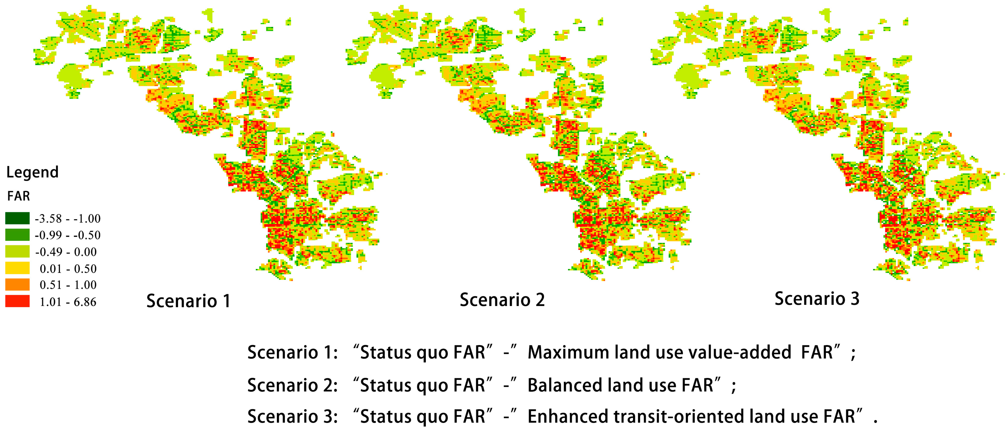
4.3. Comparison between the “Ideal” and Empirical Models
5. Discussion
5.1. The Determinants of Urban Intensity in Beijing
5.2. Deviation of the Urban Intensity from the Classic Location Theory: An Explanation
5.3. Planning Implications
5.4. Limitations and Prospects
6. Conclusions
Author Contributions
Funding
Data Availability Statement
Conflicts of Interest
References
- Northam, R.M. Urban Geography; John Wiley & Sons: Hoboken, NJ, USA, 1979. [Google Scholar]
- Shi, X.; Wang, J.; Yang, M. Review and Exploration of Beijing’s Master Plan (2016–2035) Evaluation. Urban Plan. Forum 2019, 3, 66–73. (In Chinese) [Google Scholar]
- Cheng, J.; Masser, I. Urban growth pattern modelling: A case study of Wuhan city, PR China. Landsc. Urban Plan. 2003, 62, 199–217. [Google Scholar] [CrossRef]
- Bertaud, A. Metropolis: A Measure of the Spatial Organization of 7 Large Cities. Unpubl. Work. Pap. 2001, 1–21. Available online: http://alainbertaud.com/ (accessed on 1 September 2022).
- Beesley, M.E.; Alonso, W. Location and Land Use: Toward a General Theory of Land Rent. Popul. Stud. 1966, 19, 326. [Google Scholar] [CrossRef]
- Ding, C. Land policy reform in China: Assessment and prospects. Land Use Policy 2003, 20, 109–120. [Google Scholar] [CrossRef]
- Li, D.; Han, G. Interrelationship between Urban Planning and Development of Beijing from 1949–2004. Soc. Sci. Beijing 2013, 5, 144–151. [Google Scholar]
- Németh, J. Defining a Public: The Management of Privately Owned Public Space. Urban Stud. 2009, 46, 2463–2490. [Google Scholar] [CrossRef]
- Rathore, M.M.; Ahmad, A.; Paul, A.; Rho, S. Urban planning and building smart cities based on the Internet of Things using Big Data analytics. Comput. Netw. 2016, 101, 63–80. [Google Scholar] [CrossRef]
- Xue, B.; Xiao, X.; Li, J. Identification method and empirical study of urban industrial spatial relationship based on POI big data: A case of Shenyang City, China. Geogr. Sustain. 2020, 1, 152–162. [Google Scholar] [CrossRef]
- Han, S.R.; Wei, S.; Zhou, W.; Zhang, M.J.; Tao, T.T.; Qiu, L.; Liu, M.S.; Xu, C. Quantifying the spatial pattern of urban thermal fields based on point of interest data and landsat images. Acta Ecol. Sin. 2017, 37, 5305–5312. [Google Scholar] [CrossRef]
- Ma, J.; Cheng, J.C.; Jiang, F.; Chen, W.; Zhang, J. Analyzing driving factors of land values in urban scale based on big data and non-linear machine learning techniques. Land Use Policy 2020, 94, 104537. [Google Scholar] [CrossRef]
- Li, S.; Ye, X.; Lee, J.; Gong, J.; Qin, C. Spatiotemporal Analysis of Housing Prices in China: A Big Data Perspective. Appl. Spat. Anal. Policy 2016, 10, 421–433. [Google Scholar] [CrossRef]
- Girres, J.-F.; Touya, G. Quality Assessment of the French OpenStreetMap Dataset. Trans. GIS 2010, 14, 435–459. [Google Scholar] [CrossRef]
- Siegan, B.H. Land use without zoning. Kyklos 1983, 36, 297–300. [Google Scholar] [CrossRef]
- Haig, R. Regional Survey of New York and Its Environs; Routledge: London, UK, 1927. [Google Scholar]
- Wheaton, W.C. Land Use and Density in Cities with Congestion. J. Urban Econ. 1998, 43, 258–272. [Google Scholar] [CrossRef]
- Fujita, M. The evolution of spatial economics: From thünen to the new economic geography. Jpn. Econ. Rev. 2010, 61, 1–32. [Google Scholar] [CrossRef]
- Solow, R.M. Congestion Cost and the Use of Land for Streets. Bell J. Econ. Manag. Sci. 1973, 4, 602. [Google Scholar] [CrossRef]
- Clark, C. Urban Population Densities. J. R. Stat. Soc. Ser. A 1951, 114, 490. [Google Scholar] [CrossRef]
- Pendall, R.; Puentes, R.; Martin, J. From Traditional to Reformed: A Review of the Land Use Regulations in the Nation’s 50 largest Metropolitan Areas. Brook. Inst. Res. Br. 2006. Available online: https://www.brookings.edu/research/from-traditional-to-reformed-a-review-of-the-land-use-regulations-in-the-nations-50-largest-metropolitan-areas/ (accessed on 1 August 2006).
- Fisher, J.C. Planning the City of Socialist Man. J. Am. Inst. Plan. 1962, 28, 251–265. [Google Scholar] [CrossRef]
- Bertaud, A. The costs of utopia: Brasilia, Johannesburg, and Moscow. Paranoá Cad. Arquitetura Urban. 1969. [Google Scholar] [CrossRef]
- Acheampong, R.A. Spatial structure, intra-urban commuting patterns and travel mode choice: Analyses of relationships in the Kumasi Metropolis, Ghana. Cities 2019, 96, 102432. [Google Scholar] [CrossRef]
- Yang, T.; Jin, Y.; Yan, L.; Pei, P. Aspirations and realities of polycentric development: Insights from multi-source data into the emerging urban form of Shanghai. Environ. Plan. B Urban Anal. City Sci. 2019, 46, 1264–1280. [Google Scholar] [CrossRef]
- Yeh, A.G.-O.; Wu, F. The transformation of the urban planning system in China from a centrally-planned to transitional economy. Prog. Plan. 1999, 51, 167–252. [Google Scholar] [CrossRef]
- Xia, C.; Yeh, A.G.-O.; Zhang, A. Analyzing spatial relationships between urban land use intensity and urban vitality at street block level: A case study of five Chinese megacities. Landsc. Urban Plan. 2020, 193, 103669. [Google Scholar] [CrossRef]
- Liu, S. Spatial Patterns and Dynamic Mechanisms of Urban Land Use Growth. Prog. Geogr. 2002, 21, 43–51. [Google Scholar]
- Qian, Z. Without zoning: Urban development and land use controls in Houston. Cities 2010, 27, 31–41. [Google Scholar] [CrossRef]
- Kruse, M. 24th smith-babcock-williams student writin competition winner: Constructing the special theater subdistrict: Culture, politics, and economics in the creation of transferable development rights. Urban Lawyer 2008, 40, 95–145. [Google Scholar]
- Carruthers, J.I.; Ulfarsson, G.F. Urban Sprawl and the Cost of Public Services. Environ. Plan. B Plan. Des. 2003, 30, 503–522. [Google Scholar] [CrossRef]
- Bertaud, A.; Brueckner, J.K. Analyzing building-height restrictions: Predicted impacts and welfare costs. Reg. Sci. Urban Econ. 2005, 35, 109–125. [Google Scholar] [CrossRef]
- Brueckner, J.K.; Sridhar, K.S. Measuring welfare gains from relaxation of land-use restrictions: The case of India’s building-height limits. Reg. Sci. Urban Econ. 2012, 42, 1061–1067. [Google Scholar] [CrossRef]
- Cao, G.; Shi, Q.; Liu, T. An integrated model of urban spatial structure: Insights from the distribution of floor area ratio in a Chinese city. Appl. Geogr. 2016, 75, 116–126. [Google Scholar] [CrossRef]
- Linkous, E.R. Transfer of development rights in theory and practice: The restructuring of TDR to incentivize development. Land Use Policy 2016, 51, 162–171. [Google Scholar] [CrossRef]
- Barr, J.; Cohen, J.P. The floor area ratio gradient: New York City, 1890–2009. Reg. Sci. Urban Econ. 2014, 48, 110–119. [Google Scholar] [CrossRef]
- Joshi, K.K.; Kono, T. Optimization of floor area ratio regulation in a growing city. Reg. Sci. Urban Econ. 2009, 39, 502–511. [Google Scholar] [CrossRef]
- Gao, X.; Asami, Y.; Katsumata, W. Evaluating Land-Use Restrictions concerning the Floor Area Ratio of Lots. Environ. Plan. C Gov. Policy 2006, 24, 515–532. [Google Scholar] [CrossRef] [Green Version]
- Martínez, F.J. The Bid—Choice Land-Use Model: An Integrated Economic Framework. Environ. Plan. A Econ. Space 1992, 24, 871–885. [Google Scholar] [CrossRef]
- Chen, J.; Kong, X.; Li, G.; Li, Y. Locaiton of public service facilities based on inversion calculation of floor area ratio. In Proceedings of the 2011 19th International Conference on Geoinformatics, Shanghai, China, 24–26 June 2011; pp. 1–5. [Google Scholar] [CrossRef]
- Li, M.; Ran, J.; Niu, X.; Shi, B. Estimating the Floor Area Ratio of the Vehicular Infrastructure Network Based on Road Grid Cell. Mob. Netw. Appl. 2019, 25, 650–659. [Google Scholar] [CrossRef]
- Chen, L.; Zhao, L.; Xiao, Y.; Lu, Y. Investigating the spatiotemporal pattern between the built environment and urban vibrancy using big data in Shenzhen, China. Comput. Environ. Urban Syst. 2022, 95, 101827. [Google Scholar] [CrossRef]
- Ma, C.-X.; Peng, F.-L. Evaluation of spatial performance and supply-demand ratios of urban underground space based on POI data: A case study of Shanghai. Tunn. Undergr. Space Technol. 2023, 131, 104775. [Google Scholar] [CrossRef]
- Ma, Y.; Yang, Y.; Jiao, H. Exploring the Impact of Urban Built Environment on Public Emotions Based on Social Media Data: A Case Study of Wuhan. Land 2021, 10, 986. [Google Scholar] [CrossRef]
- Liu, M.; Ma, J.; Zhou, R.; Li, C.; Li, D.; Hu, Y. High-resolution mapping of mainland China’s urban floor area. Landsc. Urban Plan. 2021, 214, 104187. [Google Scholar] [CrossRef]
- Qiu, Y.; Liu, Y.; Liu, Y.; Li, Z. Exploring the Linkage between the Neighborhood Environment and Mental Health in Guangzhou, China. Int. J. Environ. Res. Public Health 2019, 16, 3206. [Google Scholar] [CrossRef]
- Norman, G.J.; Nutter, S.K.; Ryan, S.; Sallis, J.F.; Calfas, K.J.; Patrick, K. Community Design and Access to Recreational Facilities as Correlates of Adolescent Physical Activity and Body-Mass Index. J. Phys. Act. Health 2006, 3, S118–S128. [Google Scholar] [CrossRef]
- Tsai, Y.-H. Location-demand-based residential floor area ratio distribution method. Urban Stud. 2013, 51, 2685–2702. [Google Scholar] [CrossRef]
- Pang, H.; Jiao, J. Impacts of Beijing bus rapid transit on pre-owned home values. J. Public Transp. 2015, 18, 34–44. [Google Scholar] [CrossRef]
- Peng, J.; Peng, F.-L.; Yabuki, N.; Fukuda, T. Factors in the development of urban underground space surrounding metro stations: A case study of Osaka, Japan. Tunn. Undergr. Space Technol. 2019, 91, 103009. [Google Scholar] [CrossRef]
- Wang, S.; Noland, R.B. Variation in ride-hailing trips in Chengdu, China. Transp. Res. Part D Transp. Environ. 2020, 90, 102596. [Google Scholar] [CrossRef]
- Chotchaiwong, P.; Wijitkosum, S. Predicting Urban Expansion and Urban Land Use Changes in Nakhon Ratchasima City Using a CA-Markov Model under Two Different Scenarios. Land 2019, 8, 140. [Google Scholar] [CrossRef]
- Han, W.; Zhang, X.; Zheng, X. Land use regulation and urban land value: Evidence from China. Land Use Policy 2019, 92, 104432. [Google Scholar] [CrossRef]
- Lau, S.; Giridharan, R.; Ganesan, S. Multiple and intensive land use: Case studies in Hong Kong. Habitat Int. 2005, 29, 527–546. [Google Scholar] [CrossRef]
- Knaapen, J.P.; Scheffer, M.; Harms, B. Estimating habitat isolation in landscape planning. Landsc. Urban Plan. 1992, 23, 1–16. [Google Scholar] [CrossRef]
- Lyu, G.; Bertolini, L.; Pfeffer, K. Developing a TOD typology for Beijing metro station areas. J. Transp. Geogr. 2016, 55, 40–50. [Google Scholar] [CrossRef]
- Xia, H.; Shen, C.; Zhang, C.; Wang, X.; Zhang, D. Challenges in the Integration of Light Rail and Land Use: A Case Study of Yizhuang Line in Beijing. Urban Rail Transit 2017, 3, 45–53. [Google Scholar] [CrossRef]
- Perloff, H. Education of City Planners: Past, Present and Future. J. Am. Inst. Plann. 1956, 22, 186–217. [Google Scholar] [CrossRef]
- Chapin, F.; Weiss, S.F. A probabilistic model for residential growth. Transp. Res. 1968, 2, 375–390. [Google Scholar] [CrossRef]
- Kantakumar, L.N.; Kumar, S.; Schneider, K. What drives urban growth in Pune? A logistic regression and relative importance analysis perspective. Sustain. Cities Soc. 2020, 60, 102269. [Google Scholar] [CrossRef]
- Anselin, L. Spatial Effects in Econometric Practice in Environmental and Resource Economics. Am. J. Agric. Econ. 2001, 83, 705–710. [Google Scholar] [CrossRef]
- Lin, J.; Li, X. Large-scale ecological red line planning in urban agglomerations using a semi-automatic intelligent zoning method. Sustain. Cities Soc. 2019, 46, 101410. [Google Scholar] [CrossRef]
- Liu, Y.; Fang, F.; Li, Y. Key issues of land use in China and implications for policy making. Land Use Policy 2014, 40, 6–12. [Google Scholar] [CrossRef]
- Corbusier, L. The Athens Charter; Grossman Publishers: New York, NY, USA, 1973. [Google Scholar]
- Pflieger, G.; Pattaroni, L.; Kaufmann, V.; Jemelin, C. How Does Urban Public Transport Change Cities? Correlations between Past and Present Transport and Urban Planning Policies. Urban Stud. 2009, 46, 1421–1437. [Google Scholar] [CrossRef]
- Davoudi, S. EUROPEAN BRIEFING: Polycentricity in European spatial planning: From an analytical tool to a normative agenda. Eur. Plan. Stud. 2003, 11, 979–999. [Google Scholar] [CrossRef]


| Category | Variable | Expected Sign a | Reference |
|---|---|---|---|
| Public services (POI proximity) | Business | + | [42] |
| Shopping | + | [43] | |
| Finance | + | [12] | |
| Medical | ? | [44] | |
| Parking | ? | [45] | |
| Primary education | + | [46] | |
| Entertainment | − | [47] | |
| Transportation (POI proximity/transportation accessibility) | Public transport stations | + | [48,49] |
| Subway stations | + | [50,51] | |
| National roads, provincial roads, county-level roads | ? | [52] | |
| Township-level Roads | + | [38] | |
| Land value | Second-hand housing transaction price | + | [36,53] |
| Land use structure | Land use mixture (number of public service types) | + | [38,54] |
| Scenario | Weighing Type | Weighing Item | Weight |
|---|---|---|---|
Maximum land use value-added | Source (POI weights) | Business: shopping: finance, medical: primary education: parking | 2/9:2/9:2/9:1/9:1/9:1/9 |
| Resistance (accessibility weights) | Road accessibility: transit station accessibility | 1:1 | |
Balanced land use | Source | Business: shopping: finance, medical: primary education: parking | 1/6:1/6:1/6:1/6:1/6:1/6 |
| Resistance | Road accessibility: transit station accessibility | 1:1 | |
Enhanced transit-oriented land use | Source | Business: shopping: finance, medical: primary education: parking | 1/6:1/6:1/6:1/6:1/6:1/6 |
| Resistance | Road accessibility: transit station accessibility | 1:2 |
| Category | Data | Contents | Source | Spatial/Temporal Resolution | Acquisition Time |
|---|---|---|---|---|---|
| Public service | Bus stations, subway stations | / | Gaode Map data development platform (https://lbs.amap.com, accessed on 1 January 2017) | 10 m/1a | January 2017 |
| National highways, provincial roads, county roads, township roads Business | / | Beijing Municipal Transportation Commission (http://jtw.beijing.gov.cn, accessed on 1 January 2017) | |||
| Mansions | 2016 Baidu Map POI Data | 10 m/0.5-2a | December 2016 | ||
| Shopping | Shopping center, supermarket, wholesale city, home appliance city, department store building | ||||
| Finance | Banks | ||||
| Entertainment | Cinemas, KTV, entertainment clubs, theaters, stadiums | ||||
| Hospital | Health centers, hospitals | ||||
| Parking | Parking | ||||
| Primary Education | Primary and secondary schools | ||||
| Housing price | Second-hand housing transaction price | / | 2018 Fangtianxia second-hand house price website (https://www.sofang.com, accessed on 1 December 2018) | 10 m/1a | December 2018 |
| Urban intensity | FAR | / | Building-level data from the 2016 Geographic State Survey and land parcel data from the Landuse Change Survey | 30 m/1-5a | December 2016 |
| Linear Regression | XGBoost | Random Forest | Gradient Boosting Regression | |
|---|---|---|---|---|
| R2 | 0.454 | 0.223 | 0.415 | 0.425 |
| Variables | Chaoyang District | Changping District | Chaoyang Central District | Changping New Town | ||||||||
|---|---|---|---|---|---|---|---|---|---|---|---|---|
| B (SE.) | Beta | VIF | B (SE.) | Beta | VIF | B (SE.) | Beta | VIF | B (SE.) | Beta | VIF | |
| Business | 0.082 *** (0.014) | 0.080 | 1.610 | −0.008 (0.040) | −0.004 | 1.201 | 0.100 *** (0.020) | 0.121 | 1.659 | 0.008 (0.068) | 0.003 | 1.258 |
| Shopping | 0.080 *** (0.012) | 0.086 | 1.385 | 0.077 *** (0.010) | 0.106 | 1.372 | 0.101 *** (0.019) | 0.119 | 1.340 | 0.059 *** (0.015) | 0.108 | 1.494 |
| Finance | 0.053 *** (0.009) | 0.090 | 1.954 | 0.008 (0.014) | 0.009 | 1.694 | 0.063 *** (0.013) | 0.130 | 1.971 | 0.007 (0.022) | 0.009 | 1.857 |
| Entertainment | −0.054 *** (−0.025) | −0.025 | 1.099 | −0.050 * (0.028) | −0.023 | 1.207 | −0.049 (0.034) | −0.028 | 1.061 | −0.079 ** (0.034) | −0.058 | 1.258 |
| Medical | −0.014 (0.017) | −0.009 | 1.022 | 0.026 (0.016) | 0.019 | 1.031 | −0.014 (0.027) | −0.010 | 1.022 | 0.035 (0.033) | 0.025 | 1.068 |
| Parking | 0.158 *** (0.016) | 0.154 | 2.076 | −0.029 (0.026) | −0.016 | 1.580 | 0.146 *** (0.024) | 0.159 | 1.865 | −0.026 (0.038) | −0.021 | 1.877 |
| Primary education | 0.034 (0.039) | 0.010 | 1.093 | −0.043 (0.040) | −0.013 | 1.092 | 0.032 (0.062) | 0.010 | 1.077 | 2.34 × 10⁻⁴ ** (0.062) | 9.27 × 10⁻⁵ ** | 1.145 |
| Bus stations | 3.05 × 10⁻⁴ ** (1.23 × 10⁻⁴ **) | 0.027 | 1.004 | 0.002 ** (0.001) | 0.026 | 1.012 | 2.95 × 10⁻⁴ *** (1.53 × 10⁻⁴ **) | 0.037 | 1.004 | 0.006 *** (0.002) | 0.074 | 1.015 |
| Subway stations | 0.111 *** (0.026) | 0.047 | 1.062 | 0.219 *** (0.028) | 0.093 | 1.046 | 0.028 (0.043) | 0.013 | 1.019 | 0.062 (0.050) | 0.029 | 1.050 |
| National, provincial, and county-level roads | −0.048 *** (0.010) | −0.050 | 1.013 | −0.015 *** (0.004) | −0.051 | 1.031 | −0.068 *** (0.024) | −0.055 | 1.023 | −0.020 *** (0.005) | −0.090 | 1.048 |
| Township-level roads | 0.019 *** (0.003) | 0.072 | 1.162 | 0.014 *** (0.002) | 0.083 | 1.114 | 0.015 ** (0.006) | 0.048 | 1.172 | 0.016 *** (0.004) | 0.107 | 1.172 |
| Ln (house price) | 0.367 *** (0.057) | 0.075 | 1.124 | 0.594 *** (0.032) | 0.226 | 1.099 | 0.043 (20.128) | 0.007 | 1.029 | 0.258 *** (0.075) | 0.081 | 1.051 |
| Land use mixture | 0.191 *** (0.013) | 0.298 | 3.232 | 0.210 *** (0.013) | 0.336 | 3.005 | 0.139 *** (0.021) | 0.206 | 2.696 | 0.228 *** (0.021) | 0.497 | 3.898 |
| Number of samples | 4948 | 5224 | 1790 | 1211 | ||||||||
| R2 | 0.413 | 0.296 | 0.348 | 0.379 | ||||||||
| Adjust R2 | 0.412 | 0.294 | 0.343 | 0.372 | ||||||||
Disclaimer/Publisher’s Note: The statements, opinions and data contained in all publications are solely those of the individual author(s) and contributor(s) and not of MDPI and/or the editor(s). MDPI and/or the editor(s) disclaim responsibility for any injury to people or property resulting from any ideas, methods, instructions or products referred to in the content. |
© 2023 by the authors. Licensee MDPI, Basel, Switzerland. This article is an open access article distributed under the terms and conditions of the Creative Commons Attribution (CC BY) license (https://creativecommons.org/licenses/by/4.0/).
Share and Cite
Lu, Q.; Ning, J.; You, H.; Xu, L. Urban Intensity in Theory and Practice: Empirical Determining Mechanism of Floor Area Ratio and Its Deviation from the Classic Location Theories in Beijing. Land 2023, 12, 423. https://doi.org/10.3390/land12020423
Lu Q, Ning J, You H, Xu L. Urban Intensity in Theory and Practice: Empirical Determining Mechanism of Floor Area Ratio and Its Deviation from the Classic Location Theories in Beijing. Land. 2023; 12(2):423. https://doi.org/10.3390/land12020423
Chicago/Turabian StyleLu, Qing, Jing Ning, Hong You, and Liyan Xu. 2023. "Urban Intensity in Theory and Practice: Empirical Determining Mechanism of Floor Area Ratio and Its Deviation from the Classic Location Theories in Beijing" Land 12, no. 2: 423. https://doi.org/10.3390/land12020423