
Living on the Edge—Mismatches and Expectations in a Changing Landscape


Centro de Investigação em Arquitetura, Urbanismo e Design, Faculdade de Arquitetura, Universidade de Lisboa, 1349-063 Lisboa, Portugal
Land 2023, 12(2), 386; https://doi.org/10.3390/land12020386
Submission received: 19 December 2022
/
Revised: 16 January 2023
/
Accepted: 21 January 2023
/
Published: 31 January 2023
(This article belongs to the Special Issue Urban Regeneration and Local Development)
Abstract
:This paper deals with the confrontation between the forms of urbanisation of Lisbon, Portugal, that extends its fringes over the Alcântara Valley. This same Valley—topography and hydrography—plays as determinants of the occupation that will assume distinct narratives. This gradual process is explained through three narratives about (1) the urbanisation of the margin driven by industrialisation and the construction of a stigmatised periphery, (2) the imposition of large capacity infrastructures far beyond what is local, (3) the system of open spaces and landscape projects and the urban brink that the valley claims. The debate focuses on the answers that the urban and landscape project, necessarily going through urban planning and its practical and theoretical scopes, i.e., Urbanism and urban planning thinking, especially in a broad present seeking to discuss both sides of the coin: on the one hand, an urban rehabilitation with public space for all, on the other hand, a qualified and central space that attracts real estate investment that may bring effects contrary to those expected. The article seeks to contribute (1) to a broader perception of the superimposition of processes that transformed the Alcântara Valley, (2) to a fuller dissemination of the urbanistic experiences in the city of Lisbon since this city is still vastly underrepresented in the international (primarily Anglo-Saxon) literature, (3) to deepen the debate between urban rehabilitation, urban regeneration, consequences and opportunities practiced is still trying to cope with.
1. Introduction
In the Alcântara Valley, the urbanisation process reveals the growing clash between a striking topo-hydrographic occurrence and mid-19th century western borders of the City of Lisbon and the urban development constrained by it but impelled by the industrial upsurge associated with the substantial harbour infills most extensive quay of the city and the railway belt.
Three narratives can be identified from the transformation processes. Albeit their different beginnings in time, they persist entangled until the present:
- Industrialisation at the end of the 19th century with new landfills and industrial perimeters, precarious urbanisation along the old Alcântara Stream, and further housing needs.
- In the first half of the 20th century, overlapping high-capacity road and rail infrastructure, such as the bridge link.
- From the 1990s onwards, the need to restore urban continuity, the qualification of public and open spaces, urban rehabilitation interventions, and the Alcântara Green Corridor under the aegis of the Lisbon Green City 2020 award.
The Alcântara Valley shows the many facets of a residual city marked by each period’s avant-garde urbanistic thinking. However, in this study, it was verified that, despite remarkable development in the Lisbon urban planning and management field, there is still some room for integration between these narratives and respective approaches. This condition opens the debate proposed in this article, about the effectiveness—social, environmental, and economic—of urban rehabilitation and regeneration, in the present context. The article unfolds in sections: 1. Introduction, 2. Materials and Methods, 3. Results: Alcântara: three narratives, one story, 4. Discussion and Conclusions: Three decades of urban planning and design, 1990–2020: Genealogy and insights.
The work is built from an urbanistic perspective, as framed in the romantic European countries, such as France, Spain, Italy, and Portugal, which led the movement in the creation of a new discipline called Urbanisme (FR) Urbanisttica (IT), Urbanismo (ES and PT), since the late 19th century [1,2,3], addressing the conception and design of the industrial city. This particular design and place-grounded perspective of the urban, as the result of distinct landscapes and cultures [4,5], would only later be included in the policy and framework European Union (EU) [6,7]. Recent perspectives in the public space design, especially in the fringe areas, often adapted to linear parks, allowed to encompass, as well, references to the landscape ecology [8] and the landscape urbanism perspective [9,10]. In its own character, the main focus of the Alcântara Development Plan, having its stream, the need to interweave urban fringes with the open space system and the infrastructures, might take the linear park concept as a backbone.
This view encompasses the territorial transformative phenomena and their changing processes, whatever their kind, in this case, a blend of marginal urbanisation and increasing derelict areas and abandoned rural structures. It addresses the material adjustments that continuously shape the fabrics.
A Valley as the Boundary of A City
Lisbon’s urbanisation is deeply marked by the opportunities offered by physiography, geostrategic location, and long-time settlement. Time, place, and people shaped the city’s facets, from vernacular to the most erudite and innovative today.
The stepped topography shapes the city, where valleys convey streams and main roads to smaller rural and riverside settlements and the main centre—earlier in Castle Hill and within the 14th-century walls. After the 1755 Earthquake, the urban design of a modern downtown (Baixa) introduced the Enlightenment’s novelties, and the city grew way off the former walls and fused with extramuros villages (see Figure 1).
Water and land constrained the urban development, casting natural territorial boundaries: to the Eastern Side, the Chelas’ system of Valleys, and to the west, the Alcântara Valley, this study’s subject. The contrasts in these then outskirts would become more emphatic, where incipient yet consistent industrial-led urbanisation encroached on former rural estates and villages in the Valleys of Chelas and Alcântara. The profoundly transformed waterfront along the Tagus Estuary offered a protected natural deep-water harbour allowing the evolution of overseas capital. These conditions would impel a fundamental waterfront axis, running the city from east to west.
By the mid-19th century, the city boundaries consisted of a ring road adapted to this topography. Such valleys and urban-related areas would turn into critical industrial nodes. They were strategically and geographically positioned to the waterfront and, later, with direct links to a goods railway belt around the city.
Lisbon Historic Cartography allows us to observe at the first stance that those were the boundaries of the city (see Figure 2a–d) and at a later one (see Figure 2e,f) that the Municipality would incorporate the adjacent municipalities, notably, starting at Chelas towards the Eastern side. Belém starts at the Alcântara Valley, towards the west. The annexation of neighbouring municipalities (Belém and Olivais) enlarged the Lisbon municipality to nearly the current boundaries, and a second ring road would wrap around.
City gates on main roads to the city centre are now embedded within the fabric or lost. Nevertheless, as soon as that threshold is crossed towards the inner side, the urban character reveals itself through the late 19th-century/early 20th-century renewal in the public space—pavements, public water-supply fountains, furniture, and trees, notably at Praça da Armada and main Alcântara main street, along with the building typologies and architectural elements, such as facades covered in pattern-tyles, iron-casted balconies and mansard rooftops. (see Figure 2c–f; Figure 7d).
2. Materials and Methods
The study design results from a long-standing observational experience, strengthened by urban design studios and amplified by primary sources (cartography, iconography, legal documents), and follows a patchwork ethnographic methodology [4,5] and the narrative theory approach [11,12,13,14,15,16], from a qualitative and cultural methodology [14,17,18,19] to the evolution of the rural-urban fabrics, i.e., place and time. Lisbon is one of the oldest continuously inhabited European cities. Besides becoming one of the best-known cultural tourist destinations, it is also the only city, as far as we know, with its own historiographical line called Olisipografia. From the 19th century onwards, a unique approach was developed, with written, narrative, iconographic and cartographic documents drawn up by illustrious figures who played essential roles in interventions in the city that have lasted until today. The many documents gave rise to the Gabinete de Estudos Olisiponenses/Olisiponenses Studies Office [20,21,22,23]. This work owes much to the 30 years of observation, reading, and identification with the spirit of Olisipography, which is still little known.
Hence the usage of the materials usually involved in such research fields—historical cartography, iconography (e.g., photographs, and others), and various documents (legislation, plans, and designs included in architectural and urban design), whose outcomes are featured, mostly as follows:
- Literature Review (see all sections)
- Desktop research at the Lisbon Municipal Archive (Arquivo Municipal de Lisboa), historical cartography and iconography, notably photographs and correlated documents linked with the site, since the late 19th century (see Section 3 Results).
- Experimental methods by design in Urban Planning and Design Studios and Workshops 2019—Workshops: (1) 2009/10, Scientific and Teaching Responsibility, Urban and Territorial Design Studio II, Master in Architecture specialising in Urbanism, with the support of the Lisbon City Council, in the provision of material, technical monitoring Urban and Spatial Planning, in the provision of material, technical monitoring, and development of the students’ work. (2) 2013, Coordination and organisation, From splinters to parks, 2nd [Urban + Landscape] design international workshop, 7–10 May, endorsed by the ISOCARP. Published [20]. (3) 2019, Coordination, Cidade [n]a Margem//City on the Edge. Alcântara: infrastructures, fabrics, landscapes, Futures Workshop, with participants from masters’ and doctoral programs in Urbanism at the Lisbon School of Architecture. Joint organisation: Lisbon School of Architecture, Universidade de Lisboa, and CIUL/Lisbon City Council with urban and landscape design senior officers. 8–15 May, CIUL.
- Observational methods through field trips and photographic documentation (August 2020, September-November 2021, March 2022) (see Section 3 Results).
- Review of urban planning documents (policies, plans, and programmes), Urbanism and public spaces design promoted by the Lisbon Council’s Urban Planning, Environment and Green Spaces, existing local plans, and projects for units at the local levels of intervention and media (Newspapers and Documentaries) (see Section 3 Results, and Section 4 Discussion).
3. Alcântara: Three Narratives, One Story
Etymologically, the word ‘Alcântara’ comes from Arabic and means “bridge" [21], a bridge made of stone, thus, an important one. However, documents refer to a possible prior existence in the Roman period, which aligns with the city’s archaeological findings along the waterfront. Alcântara was the main entrance from a Royal area, the former Belém Municipality, towards Intramuros. Even today, roads and other paths converge at that point, once a marsh and lagoon. One must, nevertheless, acknowledge that the most common way of displacement before the harbour infills was by cabotage from the pier to the pier, which most waterfront buildings had. Even today, the district boundaries are consistent with the Alcântara Valley morphology (see Figure 1).
3.1. Fringe Urbanisation in Former Rural Environs: The Birth of Stigma
In the Alcântara Valley, the urbanisation process reveals the growing clash between a top-hydrographic occurrence that defined the western border of Lisbon, contained in the first ring road, until the mid-19th century. With the arrival of industrialisation and new port and railway technologies, it was on this riverside periphery that warehouses were progressively installed to support the docks of Alcântara, reinforced by the arrival of the Lisbon railway belt. This strategic point of the anchorage from the deep waters of the Tagus Canal acquired a fundamental preponderance (1) in the context of the international maritime routes also led by the Port of Lisbon, (2) in the connection to the national railway line to Oporto and (3) in the transformation of the city.
Thus, we witnessed the progressive transformation, by successive embankments, between the lagoon and mouth of the Ribeira (Stream) de Alcântara and the coastline that acquired an industrial and Port character. This transformation occurs with the partial urbanisation of the Royal Palace of Alcântara, gone, today Calvário, along the main street of Alcântara, promoting the riverside urban axis towards Belém to the west (see Figure 2a–f, see Section 3.3).
The locus of a mixture of proto-industrial installations, mainly associated with textiles and dyeing, powered by the force of the water and rustic occupations still related to an agricultural lifestyle, unravels perpendicular to the coast and along the Ribeira de Alcântara.
Along this axis, very precarious housing buildings were located, and families occupied natural caves as well, housing a population between industrial day labour and subsistence farming. These incipient fabrics extended northwards in a multiplying process (see Figure 2e,f). It is not surprising that the northern fringes of Alcântara have become synonymous with poverty and that, over time, a social stigma has been attached to it that still persists today [22].
3.2. The Sectoral Superimposition of Modern Features: From A City Boundary to A Robust National-Level Centrality
It was then the time for ‘artificial creation’ [23] to plough the land and tunnel the Alcântara Stream. In front of the former river mouth, specialised quays grew. High-capacity infrastructures were progressively superimposed onto the Alcântara Valley decline - a water underpass, viaduct for the first motorway linking Lisbon first to the National Stadium complex (the 1940s) and later to Cascais (1990s), a bridge over the Tagus (1966), railway ring (late 1800s) and later underneath the Bridge (1998) (see Figure 3a–f), more powerful motorways interlinking metropolitan levels (Eixo Norte-Sul), and even a vital flight corridor towards the Lisbon international airport up north.
Despite an apparent confusion, the transformation of Vale de Alcântara calls for interventions of two fundamental types: as a channel space, prone to infrastructural linearity, or as a hiatus, a limit or an obstacle to be overcome.
The first perspective, channel space, is revealed in the urbanisation and progressive transformation and finally, the canalisation of the Alcântara river, along which road and rail routes stretched and connected to the Alcântara docks, assuming a progressive protagonism with the construction of the Bridge 25 de Abril. Later with its intensification with the passenger rail connection (1998) and the subsequent insertion of the North–South axis at the end of the 20th century, which would transform the north of this Valley into a junction of supra-metropolitan reach [23].
However, the links to the Port allowed the Alcântara and Rocha Conde de Óbidos Docks, contiguous to the deepest water trench of the Tagus Estuary, to perform highly contributing to the fundamental role Lisbon played in the international maritime routes. At the same time, liaising between the Railway Station Alcântara-Terra (Alcântara-Land, primarily for workers coming from the Sintra–Lisbon suburban line and working transposition of goods to the harbour from the railway belt) and the Railway Station Alcântara-Mar (Alcântara-Sea, in the Cascais–Lisbon suburban line) (see Figure 3a–f and Figure 4), maintained the pedestrian access to workers and inhabitants.
As an obstacle from the outset, the Valley of Alcântara holds the character of urban protection and containment of the urban on the first ring road, a natural moat defended a city at a higher elevation, with secure access through the Alcântara Bridge and Gate.
This obstacle was conquered by the monumental Aguas Livres Aqueduct, promoted by King João the 5th in the 18th century [24,25]. However, the new water supply network to the city of Lisbon, notably the Aqueduct, is said to be more scenic and an exercise in architectural virtuosity than supplying enough water (‘Aqueduto das Águas Livres, Lisboa’, 2018).
These trims of the rustic and proto-industrial mixture would be, again, crossed by the Duarte Pacheco viaduct that introduced the first motorways, in this case, the Cascais one, in the context of the Costa do Sol Plan and together with the plantation of the Monsanto Forest Park (late 1930s) [26]. From a perspective of the modern city expanding over the rustic, Meyer-Heine, in his Plano Geral de Urbanização de Lisboa—PGUCL (Plano de Meyer-Heine, 1967) [27], would consider this Valley an "obstacle to urban life" (author’s translation, [28,29], i.e., to urban expansion. Launching broader territorial links at the national level raised barriers to former urban continuities between settlements and brought urban decline to the local population and urban fabric.
3.3. Public and Open Space System: Beyond Inequalities or Green Branding?
The Alcântara Valley was part of the Algés Reguengo, where, in the mid-17th century, a Royal Palace and Estates (Paço de Alcântara) and related open space infrastructures were settled [30]. Other noble houses would follow, leading to a certain degree of urban development, even if extramuros. While the royal structures gave place to industrial sites in what now is Quinta do Cabrinha Neighbourhood, this noble Estate would start developing towards a proto-industrial system along the former Alcântara Stream, the current Ceuta Avenue, with the development of the dying industry (Fábrica das Chitas) and the Gunpowder Factory.
These structures and correlated housing rows would expand until the late 19th century [31]. Some places are still marked by toponymic and pre-existent shapes and buildings. Tapada da Ajuda is a botanical park with pavilions, woods, and gardens, and was a critical leisure place until the end of the monarchy (1908) [32]. Later, it would become the current Agricultural School of the University of Lisbon, under the context of the 1st Republic, since 1910.
Monsanto Forest Park would introduce a new level to the landscape value. The climate and landscape in Lisbon are barely compatible with lavish greenery. Hence, Monsanto hill was practically covered with bushes, devoid of forest traces [26] (see Figure 2 and Figure 3). The Forest Park, entirely created and planted, goes back to early 20th-century ideas then integrated by de Gröer’s garden city approach to Lisbon [27].
The Green Corridor in Alcântara aims, and to a certain extent manages, to create an open space continuity designed for different users and distances, thus increasing active and soft mobility modes (see Figure 4, Figure 5 and Figure 6a,b). Moreover, it works as a fundamental green infrastructure providing vital support as part of an ecosystem service to the city.
In the northern section of the Valley, the Museum of Water reopened the 18th-century Aqueduct as a public bridge (as it used to be until the mid-19th century) to cross the Valley between Campolide and Serafina Neighbourhood by the Monsanto Forest Park on Sundays. This decision was undertaken within the decisions embraced by Lisbon Green Capital 2020, allowing, for the first time, the use of bicycles in close connection with the new bicycle lanes promoted by the Alcântara Valley Green Corridor. The first pedestrian and bicycle bridge were inaugurated in 2018 (during the workshop City on the Edge. Alcântara: infrastructures, fabrics, landscapes), and it is becoming increasingly usual to see people use it daily.
On the night of 07 December 2022, heavy flooding, which has not been known for more than 15 years in the northern Lisbon metropolitan area, resulted from an extreme weather event of excessive rainfall. A few weeks before, an unusual phenomenon, a small tornado, occurred in Valley. A week later, Lisbon, and Alcântara in particular, was hit by extreme climatic and convective phenomena that had never been seen before.
Floods, however, with only one human loss, were extensive and will increase as a climate change consequence, as noted by Filipe Duarte Santos [33]. Oddly enough, in the 1940s, Vieira da Silva, an esteemed Engineer and Olisipographer, was already calling for those risks regarding the reorientation and tunnelling of the Alcântara Streem to insert the railway line onto it [34].
More than green branding [35], through the label of the Green European City 2020, the Alcântara Green Corridor, along the Valley interconnected with the others within a green network, is a fundamental green infrastructure in the approach to any city of the present, especially in such conditions as flood risk, as Alcântara.
If qualified public spaces are also offered to the citizens, pre-existing urban fabrics are preserved, and new ones are valued, even if some green and blue gentrification may occur [36]
A green corridor over ruined; precarious rural nuclei; abandoned amidst a sky bleak by viaducts and the roar of dusty pavement; where no one can walk yet between the sparse housing ensembles along the heavy infrastructures.
Above all, the urban continuities promoted by the public space through a green corridor or local interventions, such as the Program a Plaza for each neighbourhood [37], have not yet proven their ability to overcome the aforementioned segmented reality.
4. Three Decades of Urban Planning and Design, 1990–2020: Genealogy and Insights
The practice of urban planning and design in Portugal has been progressively recognised as being developed within the best parameters of maturity and innovation in international terms. The awards received directly (Lisbon Green European Capital 2020) or indirectly (such as those related to tourist destinations), the technical publications, and the presence in the most relevant networks of cities recognise what, sometimes, the scientific literature still does not.
Each city, each place is unique and concentrates strata from various times that, in cases like Alcântara, perhaps require a more comprehensive range of issues related to the transformations of the territory. The morphogenesis of the Alcântara Valley reveals itself in discontinuities of the landscape in its various shades (from rural to urban), administrative and jurisdictional (municipal and national level, such as the Port of Lisbon and other large capacity infrastructures) (cf Section 4.), but also unfulfilled expectations, and projects that never made it.
PEDU/Urban Development Strategic Plan is a programming instrument that encompasses 3 Action Plans that support the investment priorities inscribed in the urban axis of POR Lisboa 2020: Sustainable urban mobility (action) plan (PAMUS), Urban Regeneration Action Plan (PARU), Integrated Action Plan for Disadvantaged Communities (PAICD ) [38].
In Lisbon, particularly in Alcântara, PEDU is translated into interventions led by BIP/ZIP [39], a local participatory instrument that allows interventions within PAICD and the total overlap of the Urban Rehabilitation Area with the PARU (see Figure 1.). Under the remit of the national legal framework [40], the latter was defined as "systematic", allowing the use of different urban planning and design tools.
The first version of the Alcântara Development Plan (PUA) mainly focused on providing social housing for those living in highly precarious conditions. The area of the PUA was subdivided into Urban Detail Plans, addressing a high density of housing, except for "Casal Ventoso", a notorious slum with origins in the late 19th century, as a consequence of housing demand from the industrial areas along the Alcântara Stream [41]. It evolved in the sense authors refer to "slum" as a place with which stigma becomes associated with the people who live in those places [42,43]. The population would then be rehoused in Quinta do Cabrinha, under the remit of the PER—Special Rehousing Plan (see Table 1.) [44,45]. One must refer to that the proposals by Leopoldo de Almeida were not taken fully to the end [46,47,48], neither in the area nor any other of the city, leaving the PUA waiting for the following proposal led by Manuel Fernandes de Sá based on three fundamental elements: landscape, infrastructures, and re-establishment of pre-existing urban continuity, leading to a revised perspective of the PUA [49,50,51,52].
Although socio-political, economic, and environmental disparities have increased, the fundamental axes of the Plan, whose perimeter, scope, and programme have evolved, remain and have come to be implemented.
The PUA—Alcântara Urban Development Plan is inclusive of this variety, including Urban Design Alcântara XXI (2005, revoked in 2008) [45] and also the specific possibility of resorting to two primarily private-led Unidades de Execução/Execution Units (UE): Alcântara Nascente/Eastern [46] and Alcântara Poente/Western [47] (See Figure 4, Figure 7 and Figure 8; See Table 1)
![Land 12 00386 g007a]()
![Land 12 00386 g007b]()
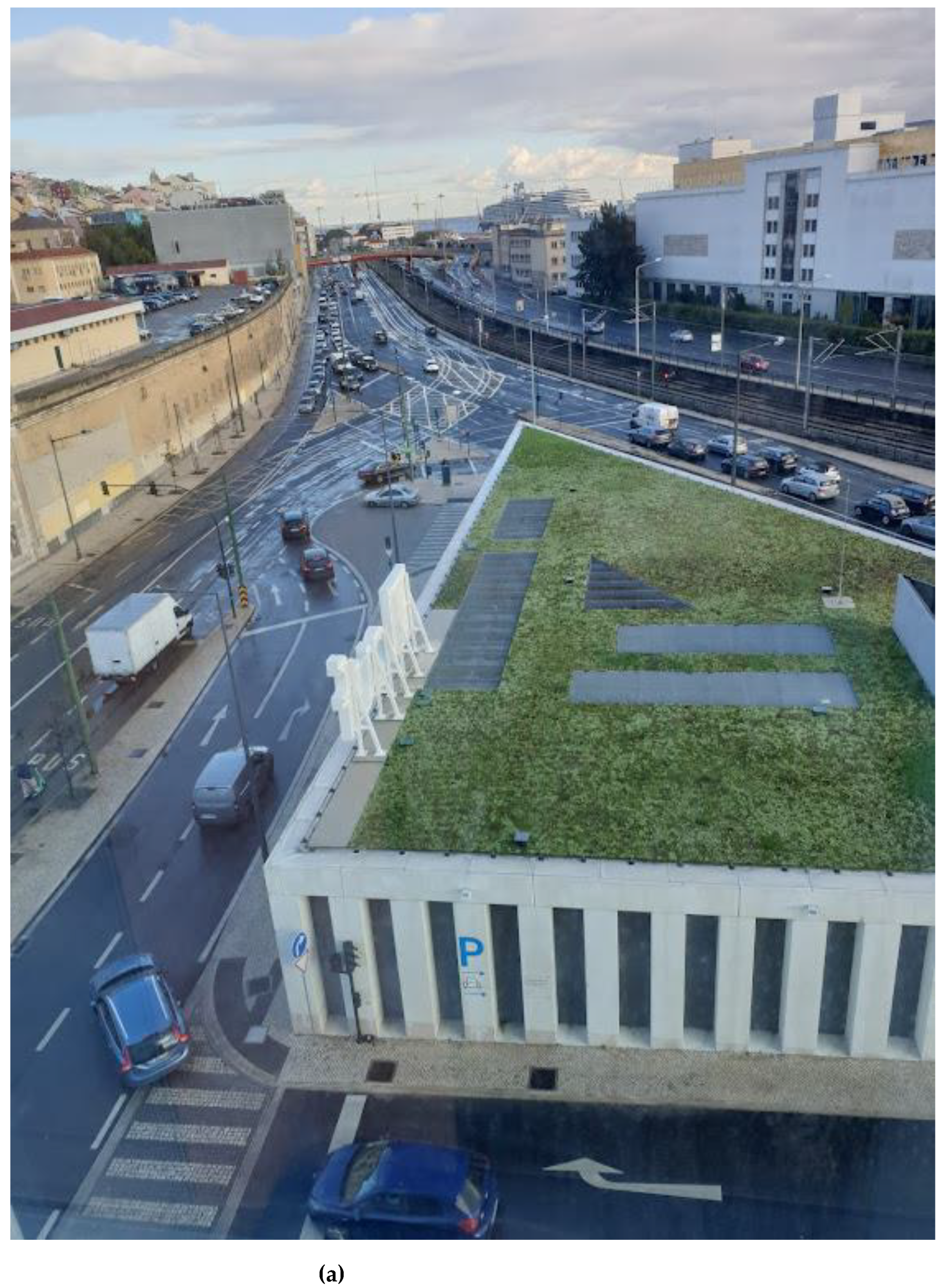
Figure 7.
Alcântara EU Nascente—CUF Hospital Source: Sofia Morgado. (a) View from the 4th floor of CUF Hospital, November 2021; (b) view from the road junction, November 2022.
Figure 7.
Alcântara EU Nascente—CUF Hospital Source: Sofia Morgado. (a) View from the 4th floor of CUF Hospital, November 2021; (b) view from the road junction, November 2022.


The Legal Regime of Urban Rehabilitation [40] establishes the various options each Municipality can implement on its land according to their corresponding needs and strategic guidelines. Given the diversity and complexity of the urban area, the Municipality of Lisbon had already identified practically all its areas requiring Urban Rehabilitation in the previous Strategic and Municipal Master Plan 1994 [47]. With the ratification of the Municipal Master Plan in 2012 [48] and subsequent legal diplomas, the Urban Rehabilitation area increased, and, as a strategic option, the Systematic Urban Rehabilitation Area option was selected [49]. The option allows greater flexibility in the type of intervention, allowing the existence of Execution Units, which are more punctual than the Detailed Plans that are dependent on the municipal public structure and the legal framework of the IGT—Territorial Management Instruments [50,51]. Even if abiding by the general guidelines required for the places of intervention, the implementation of Execution Units (EU) might provide a faster result, through private-public partnerships, with more robust real-estate development (see Table 1.).
The preliminary data of the Census 2021 to the civil parishes are in line with the observation and the review of documents. In this case, it should be noted that the PUA area covers a small percentage of the total area of four Parishes (Alcântara, Campo de Ourique, Campolide, and Estrela), from which is subtracted a substantial area of the green space associated, namely, with the Monsanto Forest Park (see Figure 1 and Figure 4.). The data show us a population decrease accompanied by a slight increase in the number of households, corresponding to a change in the family structure, which is becoming smaller. It is noteworthy, especially in Alcântara, a slight decrease in residential dwellings and yet a more substantive drop in the number of buildings, most likely corresponding to the extensive demolition of industrial buildings and others, such as smaller residential units (See Table 2.). The real-estate promotion is also leaving its footprint, and the statistics already demonstrate it, especially in the plots in Estrela.
In 2019–20, the Covid-19 pandemic settled, followed by lockdowns and effects yet to be fully assessed. On 08 December 2021, after 150 years, on one of the most revered holidays in the Portuguese catholic tradition, the Procession of Our Lady of Quietude [Quietação] returned to the streets of Alcântara, organised by one of the old 19th-century Royal Brotherhoods [61], housed by the Monastery and Church with origins in the 17th century [62,63]. People were invited to decorate windows and balconies, a community’s expression of Alcântara in the Public Space.
Back to daily life in the city, we found them like other European cities, almost on building sites. The Lisbon skyline is populated by cranes and hoists; current or more singular buildings are daily reconditioned as elegant condominiums. Holes open up in urban fronts over unexpected private terraces, giving way to a more compact and distinct occupation—in population and uses.
The waterfront is under refurbishment, but it might also become resistant to regular Lisboners. In a strip of land formerly hidden by ruined industrial storage and other facilities abandoned several decades ago (see Figure 7 and Figure 8), powerful and wealthy real estate companies openly advertise the lifestyle the city’s upgrading, in dedication to the public cause, now offers them: views of the Tagus, qualified public spaces, and an excellent public transport network.
An almost identical proposal, in concept, was set in motion by the Lisbon Port Authority (APL) in 1995, in parallel with visionary illustrations for a new compact city by Terry Farrell. This approach was supported by a well-known worldwide change reconversion and revitalisation of Port Areas, driven mainly by neoliberal choices (see Docklands, London), which was the political frame then, aiming to increase roll-on roll-off actions. Thus the usage of large container vehicles by land and the reductions of harbour works on the docks. The Plan would become known by its acronym POZOR [64]. POZOR offered a first attempt to integrate the interests of the Lisbon Port Authority, the Lisbon Municipality, and private stakeholders. POZOR would be vigorously contested during public consultation even if the Strategic Plan (March 1995) [64] presented an approach to a clear waterfront that would offer over 14 km of waterfront public open space to all that did not exist then. According to Sousa & Fernandes [65], the contestation would prevent POZOR from effective approval.
Despite the mediatic dispute that resurfaces from time to time, the containers parking in the Alcântara Dock persists. Together with the harbour cranes, they have acquired an industrial heritage personality associated with local imaginaries of the former industrial neighbourhood. This will soon change under the Lisbon Port Authority’ ’s remit to rehabilitate its valued urban areas. Public spaces inhabited by cranes, co-working spaces (e.g., LACs), and other light buildings will join the well-known recreational site for restaurants in Doca de Santo [66,67]
Reconversion of the brick storage building would revitalise the waterfront by introducing leisure activities like restaurants and public space. The waterfront would become a flagged area until these days. It is still worth mentioning the Expo’98, later the new central area Parque das Nações in the Eastern end of Lisbon.
With the gradual change of jurisdiction from the Lisbon Port Authority to the Municipality’s [68], this open space strip, now almost totally public, would become pinpointed by exquisite architectural designed public museums and other amenities, like the MAAT. A lively space for all, enjoyed by locals and of touristic interest with a growing number of visitors. The containers’ park at the Alcântara dock persists up to these days.
Paradoxically, the containers’ park in Alcântara remains and can be matched, in size and view-blocking by the common perception, by the massive buildings in the Eastern and Western Execution Units [46,47]. That specific site results from the progressive infill of a former lagoon and is under flood risk. Moreover, the area is included in the PUA perimeter under the municipality management.
Altogether, the monofunctional urban areas, which are mostly housing or correlated, aiming each at a single socio-economic group, do not seem to offer the land-use mix and the inclusive social-economic blend an actual urban centrality should call for. From lower to higher incomes, and also from the innermost noisy areas toward the waterfront and with urban functional diversity: Quinta do Cabrinha (Social Housing), Alcântara XXI [16] (see Figure 6c), and recently, the Eastern and Western Execution Units—CUF Tejo Hospital and Allo-Alcantara Lisbon Offices [69] (see Figure 7 and Figure 8, Table 1).
The current wall of wealthy housing benefits from that public space, and the view over the Tagus is there. Employing urban regeneration that allows, in this case, demolishing to build new. However, these privileged condominiums are for a few and not necessarily for permanent living. Commerce, amenities, and facilities on the same socio-economic level will follow and interfere in the adjacent diverse urban areas [70,71,72].
Although much has been done so far, recent approaches aiming at sustainable urban planning and implementing a network of environmental and landscape green corridors motivate new reflections and the side effects of rehabilitation programmes that address the "greater good". In this case, public space was also regarded as an opportunity to overcome such inequalities in Lisbon.
- Backmatter: Open-source databases are available at:
- http://lisboaaberta.cm-lisboa.pt/index.php/pt/dados/conjuntos-de-dados and https://dados.gov.pt/pt/datasets/, accessed on 14 November 2021.
- CartografiaHistorica_DuarteFava_1807. Tags Cartografia Histórica, Duarte Fava, 1807, Topografia, Topography, Historic Mapping, LimitesAdministrativos Summary Cartografia histórica, série produzida por Duarte Fava em 1807. Historic mapping produced by Duarte Fava in 1807. Credits CM LIsboa 2017 Use limitations Sem restrições de uso.
- CartografiaHistorica_1855. Tags Cartografia Histórica, 1855, Topografia, Topography, Historic Mapping, LimitesAdministrativos Summary Cartografia histórica, série produzida em 1855. Historic mapping produced in 1855. Description Cartografia histórica, série produzida em 1855. Historic mapping produced in 1855. Credits CM Lisboa 2017 Use limitations Sem restrições de uso.
- CartografiaHistorica_FilipeFolque_1856_1858. Tags Cartografia Histórica, Filipe Folque, 1856, 1858, Topografia, Topography, Historic Mapping, Limites Administrativos Summary Cartografia histórica, série produzida por Filipe Folque em 1856–1858. Historic mapping produced by Filipe Folque in 1856–1858. Description Cartografia histórica, série produzida por Filipe Folque em 1856–1858. Historic mapping produced by Filipe Folque in 1856–1858. Credits There are no credits for this item. Use limitations Sem restrições de uso.
- CartografiaHistorica_CamaraMunicipalLisboa_1871. Tags Câmara Municipal de Lisboa, Cartografia Histórica, 1871, Topografia, Topography, Historic Mapping, LimitesAdministrativos Summary Cartografia histórica, série produzida pela Câmara Municipal de Lisboa em 1871. Historic mapping produced by Lisbon City Council in 1871. Description Cartografia histórica, série produzida pela Câmara Municipal de Lisboa em 1871. Historic mapping produced by Lisbon City Council in 1871. Credits CM Lisboa 2017 Use limitations Sem restrições de uso
- Cartografia1878_FranciscoCesarGoullard, TagsTopografia, Topography, Cartografia Histórica, Historic Mapping, César Goullard, Francisco Goullard, 1878 Description Cartografia histórica, série produzida por César e Francisco Goullard em 1878. Historic mapping produced by César and Francisco Goullard in 1878. Credits CM Lisboa 2017. Use limitations Sem restrições de uso
- CartografiaHistorica_SilvaPinto_1911 Tags Cartografia Histórica, Silva Pinto, 1911, Topografia, Topography, Historic Mapping, LimitesAdministrativos. Description Cartografia histórica, série produzida por Silva Pinto em 1911. Historic mapping produced by Filipe Folque in 1911. Credits CM Lisboa 2017 Use limitations Sem restrições de uso
- Ambiente_DMEVAE. Tags Lisboa Aberta, Biodiversidade, SensingCampolide, Infraestrutura natural. Description Serviço de dados geográfico com indicação do arvoredo, elementos de água, corredor verde e hortas urbanas existentes na cidade de Lisboa. Map service locating trees, fountains and kitchen gardens in Lisbon. Credits CM Lisboa 2021 Use limitations There are no access and use limitations for this item.
- Geodados, Opendata, Planeamento, Planos, Planos de Pormenor, Planos de Urbanização, Planning, Plan, Urban Plan, Detail Plan, PlaneamentoUrbano. Summary: Disponibilizar a delimitação relativa aos Planos de Pormenor e de Urbanização e respectiva informação alfanumérica referente ao seu estado de desenvolvimento. Description: Serviço de mapa relativo à delimitação dos Planos de Pormenor e de Urbanização da cidade de Lisboa. Map service providing the limits of municipal urban and detail plans.Credits: CMLisboa 2021. Use limitations: Cartografia não homologada, não podendo ser utilizada para fins legais. Aplica-se a licença Creative Commons CCZero (http://opendefinition.org/licenses/cc-zero/ accessed 14/11/2021). A reprodução da aplicação é autorizada, devendo ser citados os créditos do autor.
- World Hillshade, available at:
- https://www.arcgis.com/home/item.html?id=1b243539f4514b6ba35e7d995890db1d, accessed 14/11/2021. Credits Sources: Esri, Airbus DS, USGS, NGA, NASA, CGIAR, N Robinson, NCEAS, NLS, OS, NMA, Geodatastyrelsen, Rijkswaterstaat, GSA, Geoland, FEMA, Intermap and the GIS user community. Use limitation: there are no access and use limitations for this item.
Funding
This research received no external funding.
Data Availability Statement
Not applicable.
Acknowledgments
The author would like to thank the Arquivo Municipal de Lisboa/Lisboa Municipal Archive for the courtesy of the historical photographs. (Available at: https://arquivomunicipal3.cm-lisboa.pt/X-arqWEB/, consulted 09/11/2021). Would also like to thank Dr Bárbara Bruno, senior historian at the Museu da Água, for the outstanding lectures about the Aqueduct throughout the years. Also, thanks to the editors, reviewers, and editing professionals for their helpful comments in improving the article.
Conflicts of Interest
The Author declares no potential conflict of interest.
References
- Os Elementos Urbanos; Coelho, D. (Ed.) Argumentum: Lisboa, Portugal, 2013; ISBN 978-972-8479-78-7. [Google Scholar]
- Llop, C.; Cervera, M.; Peremiquel, F. IV CONGRESO ISUF-H—PROGRAMA, Forma Urbis y Territorios Metropolitanos. In Metrópolis en Recomposición; Prospectivas Proyectuales En El Siglo XXI, UPC Universidad de Cataluña /Barcelona Tech: Barcelona, Spain.
- Morris, A.E.J. Historia de la Forma Urbana: Desde sus Origenes Hasta la Revolucion Industrial; Gustavo Gili: Barcelona, Spain, 1985; ISBN 978-84-252-1181-2. [Google Scholar]
- Ribeiro, O. Portugal, o Mediterrâneo e o Atlântico; Letra Livre: Lisboa, Portugal, 2021; ISBN 978-989-8268-50-1. [Google Scholar]
- Dematteis, G. Progetto Implicito: Il Contributo Della Geografia Umana Alle Scienze del Territorio; Strumenti Urbanistici; Angeli: Milano, Italy, 1995; ISBN 978-88-204-8987-8. [Google Scholar]
- Regional development studies; Office for Official Publications of the European Communities. The EU Compendium of Spatial Planning Systems and Policies; European Commission, Bernan Associates [distributor]: Lanham, Luxembourg, 1997; ISBN 92-827-9752-2. [Google Scholar]
- Dühr, S.; Colomb, C.; Nadin, V. European Spatial Planning and Territorial Cooperation; Routledge: London, UK, 2010; ISBN 0-203-89529-0. [Google Scholar]
- Forman, R.T.T. Land Mosaics: The Ecology of Landscapes and Regions; Cambridge University Press: Cambridge, UK; New York, NY, USA, 1995; ISBN 978-0-521-47462-7. [Google Scholar]
- Charles Waldheim. The Landscape Urbanism Reader; Princeton Architectural Press: New York, NY, USA, 2012; ISBN 978-1-56898-439-1. [Google Scholar]
- Charles Waldheim. Landscape As Urbanism: A General Theory; Princeton University Press: Princeton, NJ, USA, 2016; ISBN 978-0-691-16790-9. [Google Scholar]
- Aravot, I. Narrative-Myth and Urban Design. J. Archit. Educ. 1995, 49, 79–91. [Google Scholar]
- Andersen, D. Narrative Ethnography; Routledge Handbooks Online: 2020; Available online: https://www.routledgehandbooks.com/doi/10.4324/9780429320927-33 (accessed on 7 December 2022)ISBN 978-0-3637-33634-9.
- Atkinson, R. Losing One’s Place: Narratives of Neighbourhood Change, Market Injustice and Symbolic Displacement. Hous. Theory Soc. 2015, 32, 373–388. [Google Scholar] [CrossRef] [Green Version]
- Bondebjerg, I. Documentary and Cognitive Theory: Narrative, Emotion and Memory. Media Commun. 2014, 2, 13–22. [Google Scholar] [CrossRef] [Green Version]
- Budowle, R.; Sisneros-Kidd, A.M.; Stefanich, L.; Smutko, L.S. Narratives of Place: Integrated Digital Storytelling and Story-Mapping for Sustainable Recreation Management. J. Park Recreat. Adm. 2022, 40, 154–174. [Google Scholar]
- Carmona, M. Re-Theorising Contemporary Public Space: A New Narrative and a New Normative. J. Urban. Int. Res. Placemaking Urban Sustain. 2015, 8, 373–405. [Google Scholar] [CrossRef] [Green Version]
- Abascal, M.; Ganter, F. Know It When You See It? The Qualities of the Communities People Describe as "Diverse" (or Not). City Community 2022, 12, 15356841221108900. [Google Scholar] [CrossRef]
- Barrett, T. Storying Bourdieu: Fragments Toward a Bourdieusian Approach to "Life Histories. Int. J. Qual. Methods 2015, 14, 1–10. [Google Scholar] [CrossRef] [Green Version]
- Bern, A. Myths and Imaginaries in Architectural Competitions. J. Urban Des. 2022, 28, 114–135. [Google Scholar] [CrossRef]
- Morgado, S. Team from Splinters to Parks: 2nd [Urban+ Landscape] Design, International Workshop (Report), Lisbon, 2013: Lisbon, Portugal: Workshop Endorsed by ISOCARP under the Scope of "Bridging Theory and Practice.; ISOCARP—International Society of City and Regional Planners: The Hague, The Netherlands, 2013. [Google Scholar]
- Infopédia Alcântara. Dicionário Infopédia de Toponímia Infopédia—Dicionários Porto Editora. Available online: https://www.infopedia.pt/dicionarios/toponimia/Alc%C3%A2ntara (accessed on 14 November 2022).
- Hincks, S.; Powell, R. Territorial Stigmatisation beyond the City: Habitus, Affordances and Landscapes of Industrial Ruination. Env. Plan A 2022, 54, 1391–1410. [Google Scholar] [CrossRef]
- Morgado, S. Protagonismo Da Ausência—Formação Da Lisboa Metropolitana a Partir Do Espaço Desocupado [Transl: Protagonism of Absence—Formation of Metropolitan Lisbon from the Unoccupied Space]; Caleidoscópio: Casal de Cambra, Portugal, 2018; ISBN 978-989-658-541-9. [Google Scholar]
- Campos, M.; de Abreu, J.R.; de Brito, J.M.; Gião, J.d.M.; da Silva, J.S.; Mardel, C. Pareceres Sobre a Materia de Que se Devem Fazer os Canos do Aqueducto das Aguas Livres Desde o Rato até S. Pedro de Alcantara; s.n.: Lisboa, Portugal, 1747; Available online: http://purl.pt/34373 (accessed on 12 December 2022).
- Aqueduto das Águas Livres, Lisboa. Visita Guiada—RTP Play 2018. Available online: https://www.rtp.pt/play/p4530/e376476/visita-guiada (accessed on 5 December 2022).
- Tostões, A. Monsanto, Parque Eduardo VII, Campo Grande: Keil Do Amaral, Arquitecto Dos Espaços Verdes de Lisboa; Edições Salamandra: Lisboa, Portugal, 1992; ISBN 978-972-689-044-7. [Google Scholar]
- CML/Lisbon City Council Evolução do Planeamento Urbano de Lisboa. Available online: https://www.lisboa.pt/cidade/urbanismo/planeamento-urbano/evolucao (accessed on 12 December 2022).
- Morgado, S. Lisboa: Um Território Em Formação; Caleidoscópio: Casal de Cambra, Portugal, 2015; ISBN 978-989-658-164-0. [Google Scholar]
- Portaria n.o 274/77|DRE. Available online: https://dre.pt/ (accessed on 12 December 2022).
- De Andrade, L.; Álvares, A.; da Câmara, M.D.S. Breve Relaçam do Svmptvoso Enterro qve se fes em 17. de Mayo de 1653. ao Serenissimo Principe o S. D. Theodosio, Desde os Paços de Alcantara, ao Real Conuento de Belem, onde foy Depositado; por Antonio Alvarez: Lisboa, Portugal, 1653. [Google Scholar]
- Toponímia de Lisboa A Rua Da Quinta Do Cabrinha e a Fábrica Cabrinha. Available online: https://embed.tumblr.com/widgets/share/button?canonicalUrl=https%3A%2F%2Ftoponimialisboa.wordpress.com%2F2018%2F02%2F22%2Fa-rua-da-quinta-do-cabrinha-e-a-fabrica-cabrinha%2F&postcontent%5Btitle%5D=A%20Rua%20da%20Quinta%20do%20Cabrinha%20e%20a%20F%C3%A1brica%20Cabrinha&postcontent%5Bcontent%5D=https%3A%2F%2Ftoponimialisboa.wordpress.com%2F2018%2F02%2F22%2Fa-rua-da-quinta-do-cabrinha-e-a-fabrica-cabrinha%2F (accessed on 12 December 2022).
- Abreu, J.A. de Planta da real tapada da Ajuda Off. Lith. da Rua Nova dos Martyres: Lisboa. 1849. Available online: https://purl.pt/1668 (accessed on 12 December 2022).
- Em Alta Voz—Filipe Duarte Santos—Geofísico e Professor Universitário. Available online: https://www.tsf.pt/programa/em-alta-voz/emissao/filipe-duarte-santos---geofisico-e-professor-universitario-15493716.html (accessed on 19 December 2022).
- Revista Municipal; Publicação Cultural da C.M.L: Lisboa, Portugal, 1945; pp. 41–46.
- Demaziere, C. Green City Branding or Achieving Sustainable Urban Development? Reflections of Two Winning Cities of the European Green Capital Award: Stockholm and Hamburg. Town Plan. Rev. 2020, 91, 373–396. [Google Scholar] [CrossRef]
- Falanga, R.; Verheij, J.; Bina, O. Green(Er) Cities and Their Citizens: Insights from the Participatory Budget of Lisbon. Sustainability 2021, 13, 8243. [Google Scholar] [CrossRef]
- Uma Praça em Cada Bairro. Available online: https://www.lisboa.pt/cidade/urbanismo/espaco-publico/uma-praca-em-cada-bairro (accessed on 12 December 2022).
- CML/Lisbon City Council Plano Estratégico de Desenvolvimento Urbano (PEDU). Available online: https://www.lisboa.pt/cidade/urbanismo/planeamento-urbano/teste-outros-estudos-e-planos/plano-estrategico-de-desenvolvimento-urbano (accessed on 11 November 2022).
- CML/Lisbon City Council Energia BIP/ZIP: Programa BIP/ZIP. Available online: https://bipzip.lisboa.pt/conhece-os-bipzip/programa-bipzip/index.htm (accessed on 12 December 2022).
- Assembleia da República Portuguesa, Decreto-Lei n.o 80/2015, de 14 de Maio Aprova A Revisão Do Regime Jurídico Dos Instrumentos De Gestão Territorial (Versão Actualizada). Available online: http://www.pgdlisboa.pt/leis/lei_mostra_articulado.php?nid=2333&tabela=leis&so_miolo= (accessed on 23 November 2021).
- A Estratégia e a Prática do Planeamento Urbanístico em Lisboa 1990–1995; Ferreira, F.; António, S.B.; Jorge, L.; Craveiro, T.M. (Eds.) Câmara Municipal de Lisboa-Direção Municipal de Plaenamento Estratégico de Lisboa: Lisboa, Portugal, 1995. [Google Scholar]
- Finch, J. The Origin of Slum as a Trans-Class Concept. J. Urban Hist. 2022, 00961442221127054. [Google Scholar] [CrossRef]
- Laura Massidda, A. Slums, Villas Miseria, and Barriadas: Why Terms Matter. J. Urban Hist. 2022, 00961442221127308. [Google Scholar] [CrossRef]
- Manuel Fernandes de Sá Lda; CML/Lisbon City Council. Plano De Urbanização De Alcântara, Proposta De Plano—Setembro; CML/Lisbon City Council: Lisboa, Portugal, 2012; p. 47. [Google Scholar]
- CML/Lisbon City Council Plano Estratégico de Lisboa—PEL—1992. Available online: https://www.abebooks.com/PLANO-ESTRAT%C3%89GICO-LISBOA/30859840553/bd (accessed on 14 November 2022).
- Dias, L.F.; Morgado, S.; Costa, J.P.T.A. Assessing Urban Resilience in the Metropolitan Area of Lisbon: The Case of Alcântara. Resil. Think. Urban Plan. Springer Dordr. 2013, 145–159. [Google Scholar]
- CML/Lisbon City Council Alcântara Nascente—Unidade de Execução. Available online: https://www.lisboa.pt/cidade/urbanismo/planeamento-urbano/unidades-de-execucao/detalhe/alcantara-nascente (accessed on 11 November 2022).
- CML/Lisbon City Council Relatório Da Proposta De Plano Diretor Municipal De Lisboa; CML/Lisbon City Council: Lisboa, Portugal, 2012.
- CML/Lisbon City Council Estratégia de Reabilitação Para Lisboa (ERU)—2011–2024, CML: Lisboa. Available online: https://www.lisboa.pt/fileadmin/cidade_temas/urbanismo/reabilitacao_Urbana/documentos/estrategia_reabilitacao.pdf (accessed on 29 April 2021).
- Assembleia da República Protuguesa, DR Lei n.o 31/2014, de 30 de Maio, Lei De Bases Gerais Da Política Pública De Solos, De Ordenamento Do Território E De Urbanismo (Versão Actualizada). 2014. Available online: https://www.pgdlisboa.pt/leis/lei_mostra_articulado.php?nid=2123&tabela=leis&so_miolo (accessed on 10 December 2022).
- Regime Jurídico dos Instrumentos de Gestão Territorial. Available online: https://dre.pt/legislacao-consolidada/-/lc/105297982/view?p_p_state=maximized (accessed on 21 April 2021).
- National Structures—NUTS—Nomenclature of Territorial Units for Statistics—Eurostat. Available online: https://ec.europa.eu/eurostat/web/nuts/national-structures (accessed on 10 December 2022).
- PDM em Vigor. Available online: https://www.lisboa.pt/cidade/urbanismo/planeamento-urbano/plano-diretor-municipal/pdm-em-vigor (accessed on 11 December 2022).
- Aviso n.o 11622/2012|DRE. Available online: https://dre.tretas.org/dre/303385/aviso-11622-2012-de-30-de-agosto (accessed on 11 December 2022).
- Aviso n.o 2026/2015|DRE. Available online: https://dre.pt/dre/detalhe/aviso/2026-2015-66567213 (accessed on 12 December 2022).
- Planta_de_zonamento_28222_2.Jpg (2740 × 4210). Available online: https://ssaigt.dgterritorio.pt/i/Planta_de_zonamento_28222_2.jpg (accessed on 12 December 2022).
- Imo Health—Investimentos Imobiliários, Unip., Lda Proposta de Delimitação Da Unidade de Execução de Alcântara Nascente—Termos de Referência. Available online: https://www.lisboa.pt/fileadmin/cidade_temas/urbanismo/planeamento_urbano/unidades_execucao/alcantara_nascente/uni_exe_alcant_nascente_termos_referencia.pdf (accessed on 11 December 2022).
- Declaração n.o 70/2020|DRE. Available online: https://dre.pt/dre/detalhe/declaracao/70-2020-141967637 (accessed on 11 December 2022).
- Declaração (Extrato) n.o 74/2022|DRE. Available online: https://dre.pt/dre/detalhe/declaracao-extrato/74-2022-182310166 (accessed on 11 December 2022).
- Os_demais_elementos_do_plano_afetados_64354_1106_PZI_Sul.Jpg (6848 × 10522). Available online: https://ssaigt.dgterritorio.pt/i/Os_demais_elementos_do_plano_afetados_64354_1106_PZI_Sul.jpg (accessed on 11 December 2022).
- Martins, A.C. Procissão de Nossa Senhora da Quietação volta às ruas de Alcântara... 150 anos depois; Diário de Notícias: Lisboa, Portugal, 2021. [Google Scholar]
- del Espíritu Santo, C.; de las Llagas, J.; de Araújo, F.; Craesbeeck, P. Relacion de Como se ha Fvndado en Alcantara de Portvgal Ivnto a Lisboa, el Muy Deuoto Monasterio de N. S. de la Quietacion, por la Catholica Magestad del Rey N. S. D. Phelippe II. de Gloriosa Memoria para las Monjas Peregrinas de S. Clara de la Primera Regla; por Pedro Craesbeeck Impressor del Rey: Lisboa, Portugal, 1627. [Google Scholar]
- SIPA/DGPC Mosteiro de Nossa Senhora da Quietação/Mosteiro das Flamengas/Igreja de Nossa Senhora da Quietação IPA.00005940 Portugal, Lisboa, Lisboa, Alcântara. Available online: http://www.monumentos.gov.pt/Site/APP_PagesUser/SIPA.aspx?id=5940 (accessed on 10 December 2021).
- APL. Ordenamento Do Porto de Lisboa: Documento Síntese; Administração do Porto de Lisboa: Lisboa, Portugal, 1995; p. 51. [Google Scholar]
- de Sousa, J.F.; Fernandes, A. Metamorfoses da cidade portuária: Transformações da relação entre o porto e a cidade de Lisboa. Confins. Rev. Fr.-Brésilienne De Géographie/Rev. Fr.-Bras. De Geogr. 2012. [Google Scholar] [CrossRef]
- da Cunha, A. Doca de Alcântara vai Ganhar Nova Vida: Menos Carros e Mais Verde, Devolvendo o Porto de Lisboa à Cidade. Available online: https://amensagem.pt/2022/12/05/doca-de-alcantara-requalificacao-projeto-arquitetura-urbanismo-menos-carros-porto-lisboa/ (accessed on 9 December 2022).
- Group Global Media; TSF. Carlos Correia—Presidente da Administração do Porto de Lisboa; Negócios em Português: Lisboa, Portugal, 2022. [Google Scholar]
- CML/DMPU/DPU Enquadramento. Plano Geral de Intervenções Da Frente Ribeirinha de Lisboa; 2008. Available online: http://www.lisboa.pt/cidade/urbanismo/planeamento-urbano/teste-outros-estudos-e-planos/plano-geral-de-intervencoes-na-frente-ribeirinha. (accessed on 11 November 2022).
- LJ-Group Allo-Alcantara Lisbon Offices. Available online: https://lj-g.com/projects/allo-alcantara-lisbon-offices/ (accessed on 11 November 2022).
- Yagci, E.; Nunes da Silva, F. The Future of Post-Industrial Landscapes in East Lisbon: The Braço de Prata Neighbourhood. Sustainability 2021, 13, 4461. [Google Scholar] [CrossRef]
- Falanga, R.; Nunes, M.C. Tackling Urban Disparities through Participatory Culture-Led Urban Regeneration. Insights from Lisbon. Land Use Policy 2021, 108, 105478. [Google Scholar] [CrossRef]
- Seixas, J.; Guterres, A.B. Political Evolution in the Lisbon of the Digital Era. Fast Urban Changes, Slow Institutional Restructuring and Growing Civic Pressures. Urban Res. Pract. 2019, 12, 99–110. [Google Scholar] [CrossRef]
Figure 1.
The Municipality of Lisbon, municipal and district boundaries, Urban Rehabilitation Area, Development Plan for Alcântara. Sources: Own production adapted from CML open-source databases (see Backmatter).
Figure 1.
The Municipality of Lisbon, municipal and district boundaries, Urban Rehabilitation Area, Development Plan for Alcântara. Sources: Own production adapted from CML open-source databases (see Backmatter).

Figure 2.
Historical Cartography of Lisbon (excerpt superimposed by the active Urban Development Plan (dashed line, dark red) for Alcântara. Sources: Own production over CML open-source databases (see Backmatter) (a) Duarte Fava Lisbon Map—1807. (b) Lisbon Map—1855. (c) Filipe Folque Lisbon Map—1855–56 (d) Francisco & Cesar Goullard Lisbon Map—1878. (e) Lisbon Map—1855 [superimposition in red with the Ressano Garcia Plans; Vieira da Silva collection]. (f) Silva Pinto Lisbon Map—1904–11.


Figure 3.
Historical Photographs—courtesy of the Lisbon Municipal Archive. (a) Aguas Livres Aqueduct and Rabicha bridge over the Alcântara Stream—Source: [Aqueduto das Águas Livres e ponte da Rabicha, sobre a Ribeira de Alcântara], [c.1912], Paulo Guedes, photographer, PT/AMLSB/CMLSBAH/PCSP/004/PAG/000396; (b) Águas Livres Aqueduct over Ceuta avenue—Source: [Aqueduto das Águas Livres sobre a avenida de Ceuta], [c. 1949], Horácio Novais, PT/AMLSB/CMLSBAH/PCSP/004/HNV/000050. (c) Visit of the Lisbon City Council to the opening works of the Avenida de Ceuta near the Santana de Cima viaduct -Source: Visita da vereação da Câmara Municipal de Lisboa às obras de abertura da avenida de Ceuta junto ao viaduto de Santana de Cima, 1949-01-22, Câmara Municipal de Lisboa. Repartição dos Serviços Culturais. Secção de Propaganda e Turismo, PT/AMLSB/SPT/000007, (d) Construction work for the 25th of April Bridge -Source: Obras para construção da Ponte 25 de Abril, 1964, Casa Fotográfica Garcia Nunes, PT/AMLSB/CMLSBAH/PCSP/004/NUN/000651. (e) 25th of April Bridge under construction -Source: Ponte 25 de Abril em construção, 1964, Casa Fotográfica Garcia Nunes, PT/AMLSB/CMLSBAH/PCSP/004/NUN/000659. (f) Avenida Calouste Gulbenkian and accesses to 25th of April Bridge and the Santana de Cima viaduct—Source: Avenida Calouste Gulbenkian e acessos à Ponte 25 de Abril e o viaduto de Santana de Cima, 1967, Artur Inácio Bastos, PT/AMLSB/CMLSBAH/PCSP/004/AIB/001664.

Figure 4.
Urban Green Spaces, Alcântara Green Corridor, and the active Urban Development Plan (red) for Alcântara. Source: Own production adapted from CML open-source databases (see Backmatter, 07/11/2021).
Figure 4.
Urban Green Spaces, Alcântara Green Corridor, and the active Urban Development Plan (red) for Alcântara. Source: Own production adapted from CML open-source databases (see Backmatter, 07/11/2021).

Figure 5.
Green Corridors and Green Spaces, Green Spaces and Environment Department/Lisbon City Council, and the active Urban Development Plan (red) for Alcântara. Sources: Own production adapted from CML open-source databases (see Backmatter, 07/11/2021).
Figure 5.
Green Corridors and Green Spaces, Green Spaces and Environment Department/Lisbon City Council, and the active Urban Development Plan (red) for Alcântara. Sources: Own production adapted from CML open-source databases (see Backmatter, 07/11/2021).

Figure 6.
Alcântara Valley, November 2021. Source: Sofia Morgado. (a) Alcântara Green Corridor with the Tagus, towards the south, from the Aqueduct; (b) Alcântara Green Corridor and Campolide Train Station, new works, towards the north, from the Aqueduct; (c) Alcântara XXI, (d) Alcântara main street, former city gate through the Bridge, towards the city mid-19th century Intramuros.


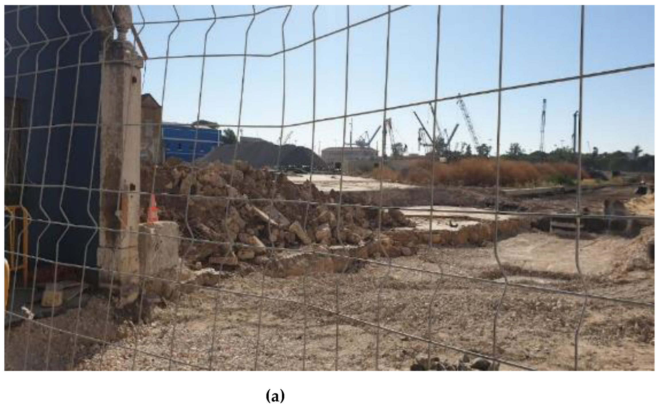
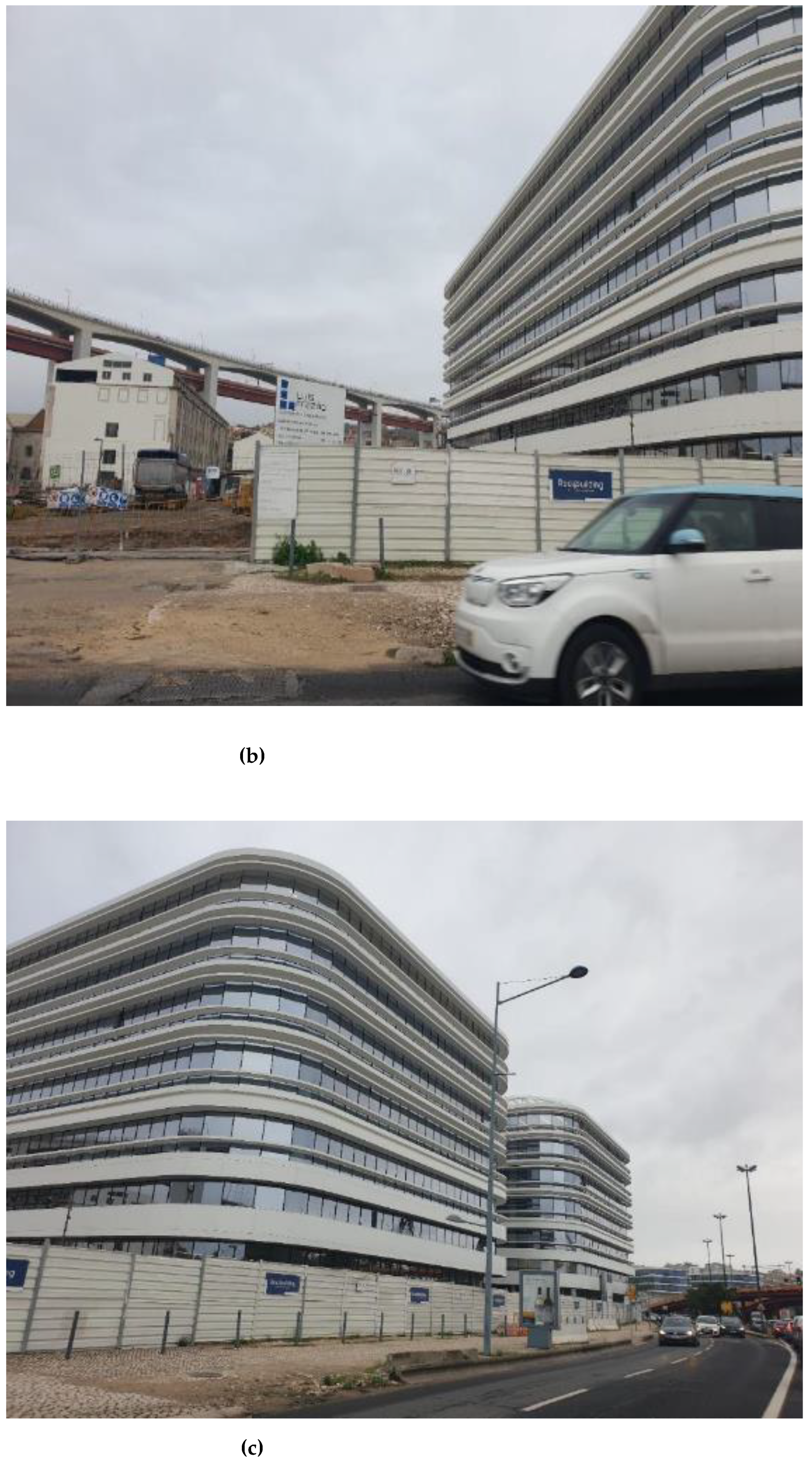
Figure 8.
EU Poente—Allo, Source: Sofia Morgado. (a) The recently clean plot, seen from Rua da Junqueira, August 2020 (b) Work in progress, new office buildings Allo, November 2022 (c) Allo and CUF Hospital, the new urban facet towards Avenida 24 de Julho, November 2022.
Figure 8.
EU Poente—Allo, Source: Sofia Morgado. (a) The recently clean plot, seen from Rua da Junqueira, August 2020 (b) Work in progress, new office buildings Allo, November 2022 (c) Allo and CUF Hospital, the new urban facet towards Avenida 24 de Julho, November 2022.


Table 1.
Urban Planning and Design in Alcântara—a genealogy. Sources: own production Cf. References inline.
Table 1.
Urban Planning and Design in Alcântara—a genealogy. Sources: own production Cf. References inline.
| Master Plan for the City (PDM) | Urban Development Plan (PU) | Urban Detail Plan (PP); Urban Design, Housing or Execution Units (EU) | Programs and Related Strategies and Action Plans | |
|---|---|---|---|---|
| 1992 | PEL (Lisbon Strategic Plan) [47] | 1987–1994—Municipal Medium-Term Intervention Programme (PIMP) [28] | ||
| 1994 | PDM [27] | |||
| 1995 | UOP (operational planning unit) 18—Alcântara Valley corresponding to an Urban Development Plan (PUA – Plano de urbanização de Lisboa), subdivided into several Urban Detail Plans (PP), including the Casal Ventoso, aiming at housing reconversion and green protection area, including demolition of slum and rehousing at a new neighbourhood under the remit of PER—Avenida de Ceuta(under consideration by the CML, Cf [41] All by Leopoldo de Almeida | National Special Programme for Housing (PER) [45] | ||
| 1998 | Quinta do Cabrinha Municipal Social Housing Project, under the remit of PER [31,41] | |||
| 2005 | Alcântara XXI (revoked 2008) [45,53] | |||
| 2011 | ERU—Strategy for the Urban Rehabilitation [49] | |||
| 2012 | PDM approval [54] | PUA Alcântara [44] | ||
| 2015 | PUA approval [55,56] | EU Alcântara Nascente—CUF Hospital [46,57] | ||
| 2016 | PEDU/Urban Development Strategic Plan [38] | |||
| 2017 | EU Alcântara Poente—Allo [47] | |||
| 2020 | PDM Alteration by adaptation [58] | |||
| 2022 | PUA Alcântara Alteration by adaptation [59,60] | |||
Table 2.
Population and Buildings Variation, Census 2011–2021. Lisbon Municipality and the Districts partially affected by the PUA—Alcântara Urban Development Plan. Source: Adapted from INE/Statistics Portugal, INE/Statistics Portugal, Preliminary data, Census 2021, available at https://censos.ine.pt/, consulted 23 November 2021).
| Municipality 1 | Population Variation 2011–2021 | Households 2011–2021 | Dwellings 2011–2021 | Buildings Variation 2011–2021 |
|---|---|---|---|---|
| % | % | % | % | |
| Lisboa | −1.4 | −1.5 | −2.1 | −5.90 |
| Civil Parishes 1 | % | % | ||
| Alcântara | −0.80 | 1.3 | −0.8 | −7.8 |
| Campo de Ourique | 0.20 | −1.4 | −1.3 | −6.70 |
| Campolide | −4.40 | −1.2 | −1.5 | −8.30 |
| Estrela | 0.60 | −4.3 | −3.8 | −1.80 |
1 Only the districts encompassing the Alcântara Urban Development Plan (PUA) Campo de Ourique and Campolide are irrelevant in this respect, as the area that overlaps is primarily open space included or contiguous to the Alcântara Green Corridor. NB: Concepts definitions, available at https://smi.ine.pt/, accessed on 24 November 2021, in Portuguese. NUTS Levels and national administrative units: LAU Level 1—Município = Municipality, LAU level 2—Civil Parishes = Freguesia) [52].
Disclaimer/Publisher’s Note: The statements, opinions and data contained in all publications are solely those of the individual author(s) and contributor(s) and not of MDPI and/or the editor(s). MDPI and/or the editor(s) disclaim responsibility for any injury to people or property resulting from any ideas, methods, instructions or products referred to in the content. |
© 2023 by the author. Licensee MDPI, Basel, Switzerland. This article is an open access article distributed under the terms and conditions of the Creative Commons Attribution (CC BY) license (https://creativecommons.org/licenses/by/4.0/).
Share and Cite
MDPI and ACS Style
Morgado, S. Living on the Edge—Mismatches and Expectations in a Changing Landscape. Land 2023, 12, 386. https://doi.org/10.3390/land12020386
AMA Style
Morgado S. Living on the Edge—Mismatches and Expectations in a Changing Landscape. Land. 2023; 12(2):386. https://doi.org/10.3390/land12020386
Chicago/Turabian StyleMorgado, Sofia. 2023. "Living on the Edge—Mismatches and Expectations in a Changing Landscape" Land 12, no. 2: 386. https://doi.org/10.3390/land12020386
Note that from the first issue of 2016, this journal uses article numbers instead of page numbers. See further details here.