
An Anthropogenically Created Landscape as a Habitat for the European Ground Squirrel Population Using the Example of the Muránska Planina National Park in the Western Carpathians (Slovakia)

Abstract
:1. Introduction
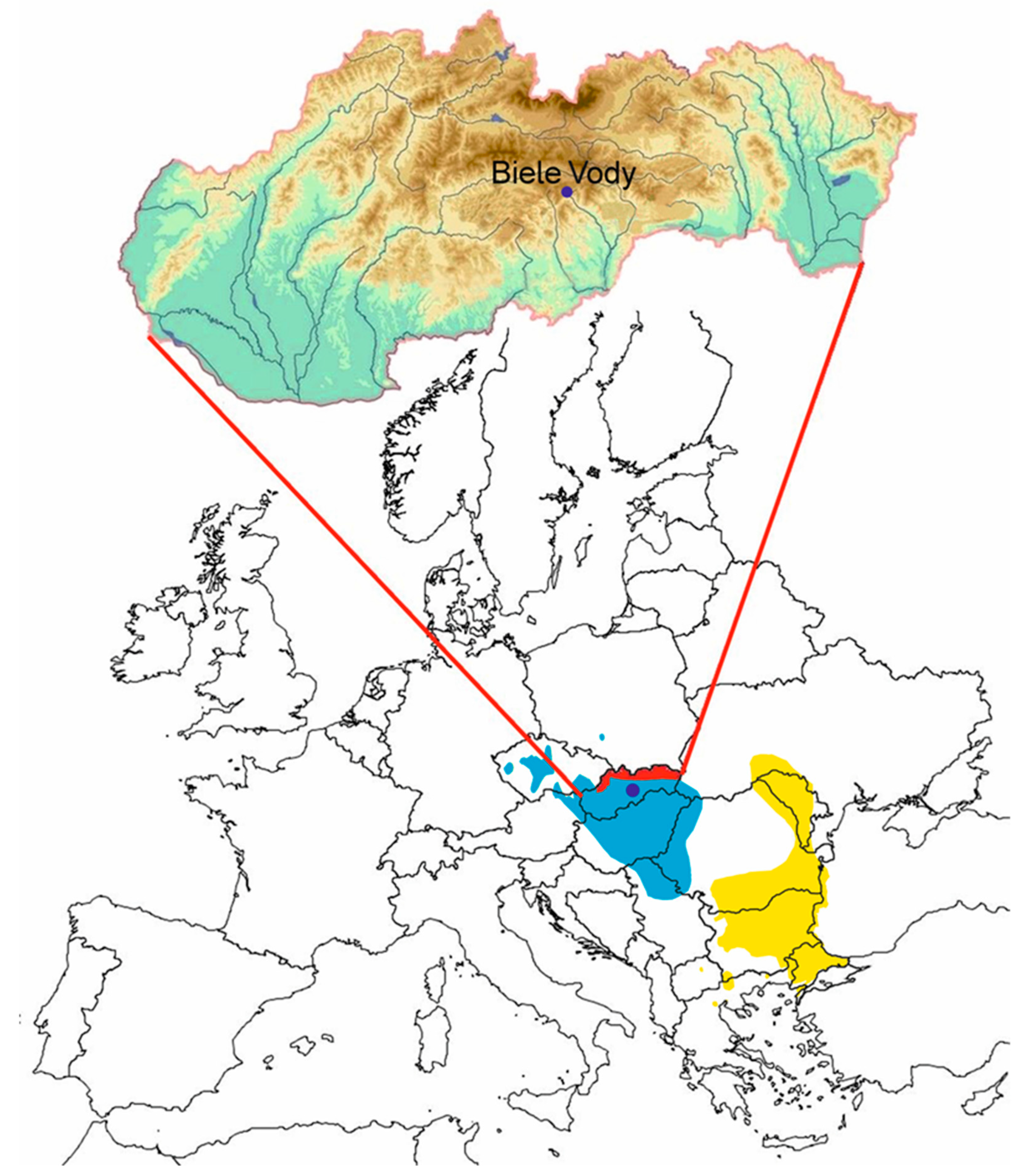
2. Study Area
3. Materials and Methods
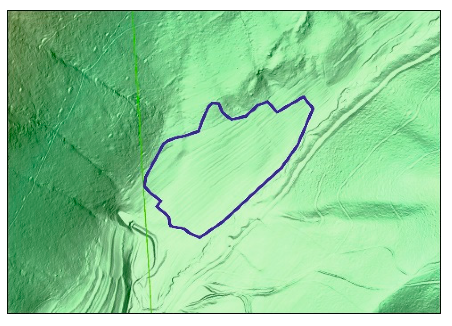
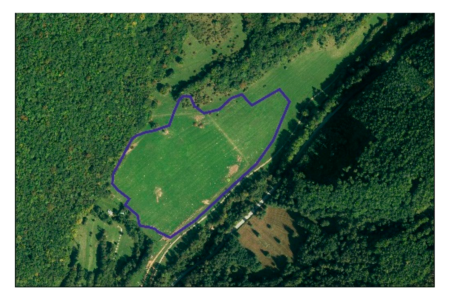
3.1. Delimitation of the Study Area
3.2. Methodology of the Research
- Potential natural vegetation [45]
- I. military mapping from the 1780s of the 18th century; II. military mapping—1860s of the 19th century (available online: https://maps.arca-num.com/en/browse/composite/, accessed on 8 April 2023)
- aerial photographs from 1950
- digital layers of CORINE land cover from 2018 (available online: http://coperni-cus.sazp.sk/#mapovy-prehliadac, accessed on 8 April 2023) aimed at identifying the historical land use of the study area.
4. Results
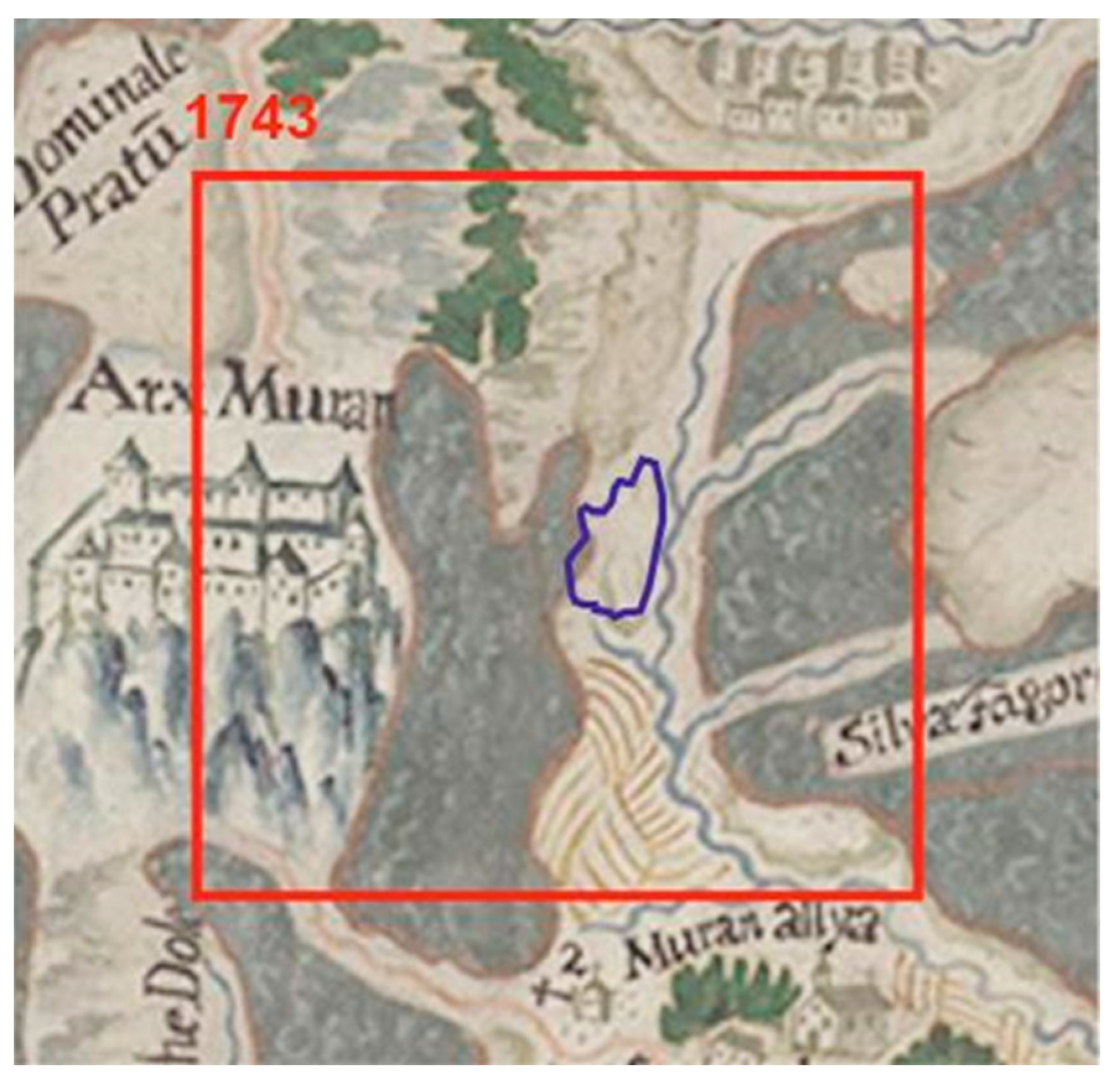
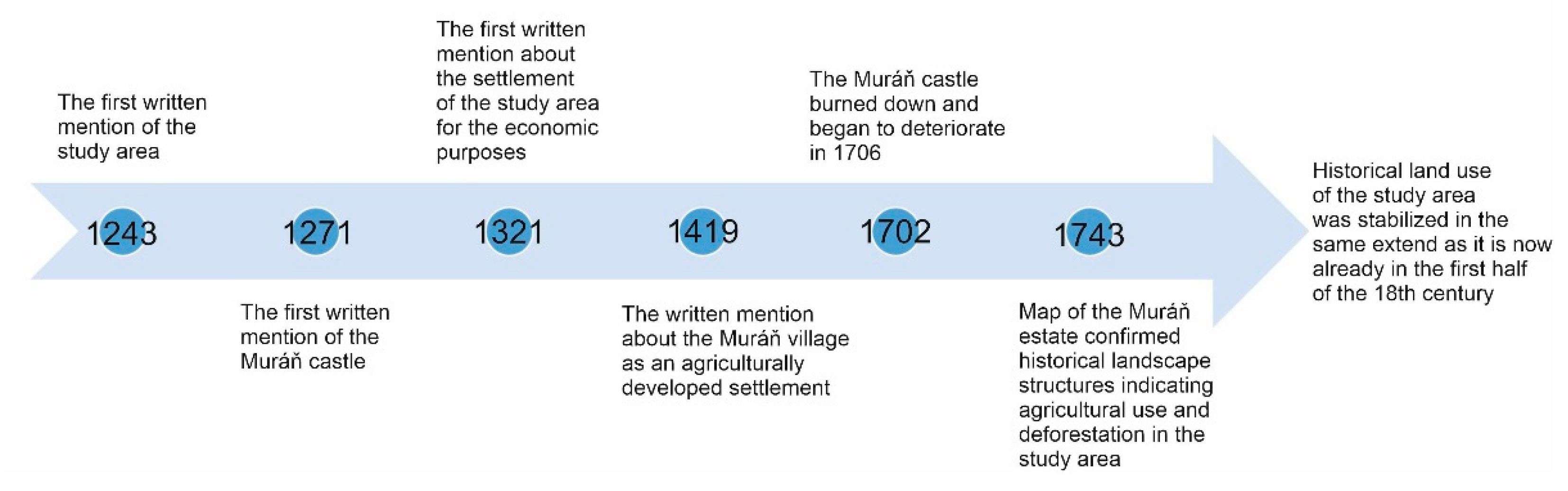
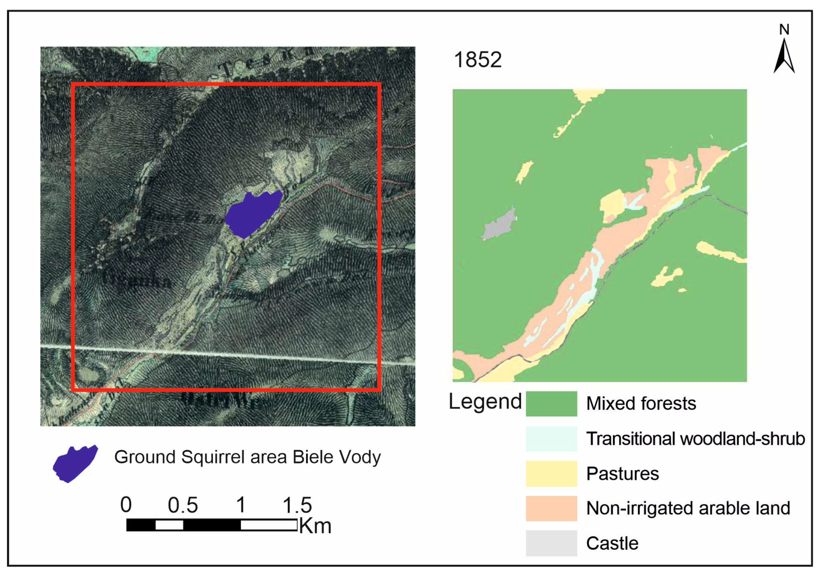
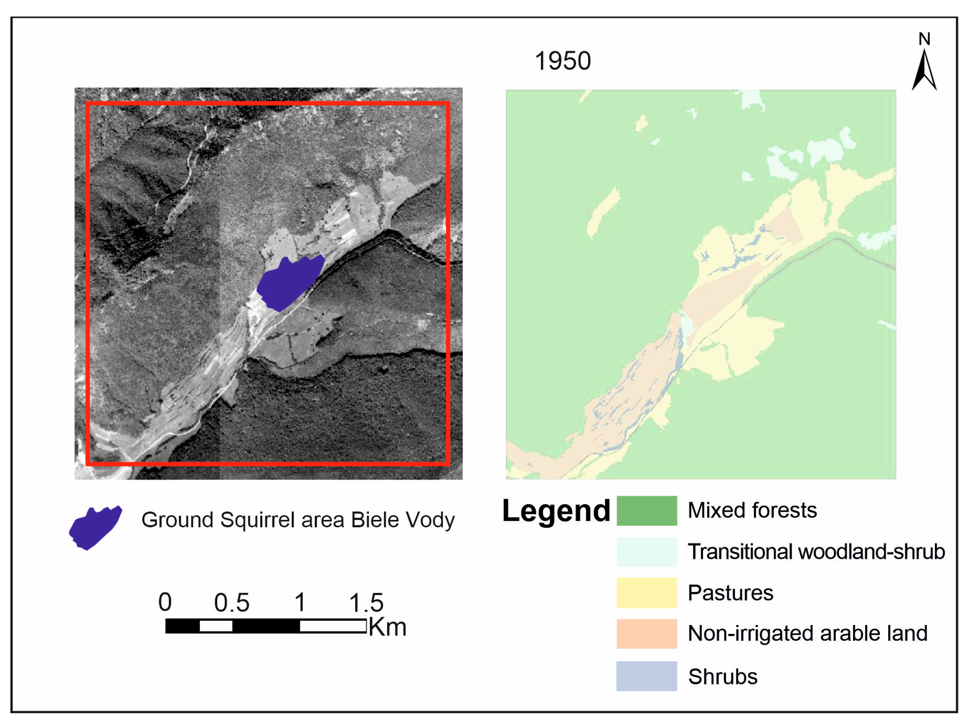
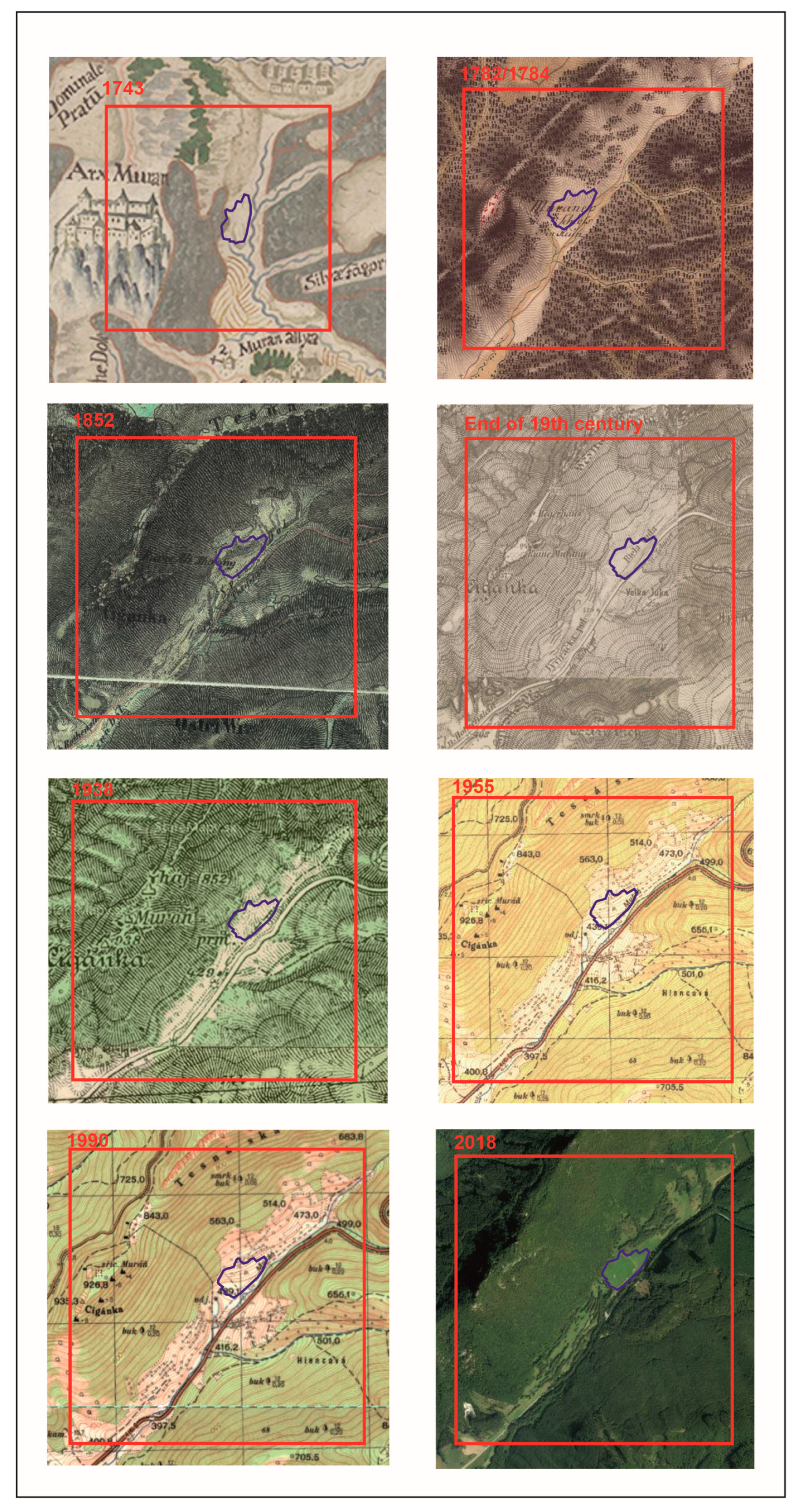
4.1. Development and Emergence of the Cultural Landscape of the Studied Area (Historical-Geographical Reconstruction)
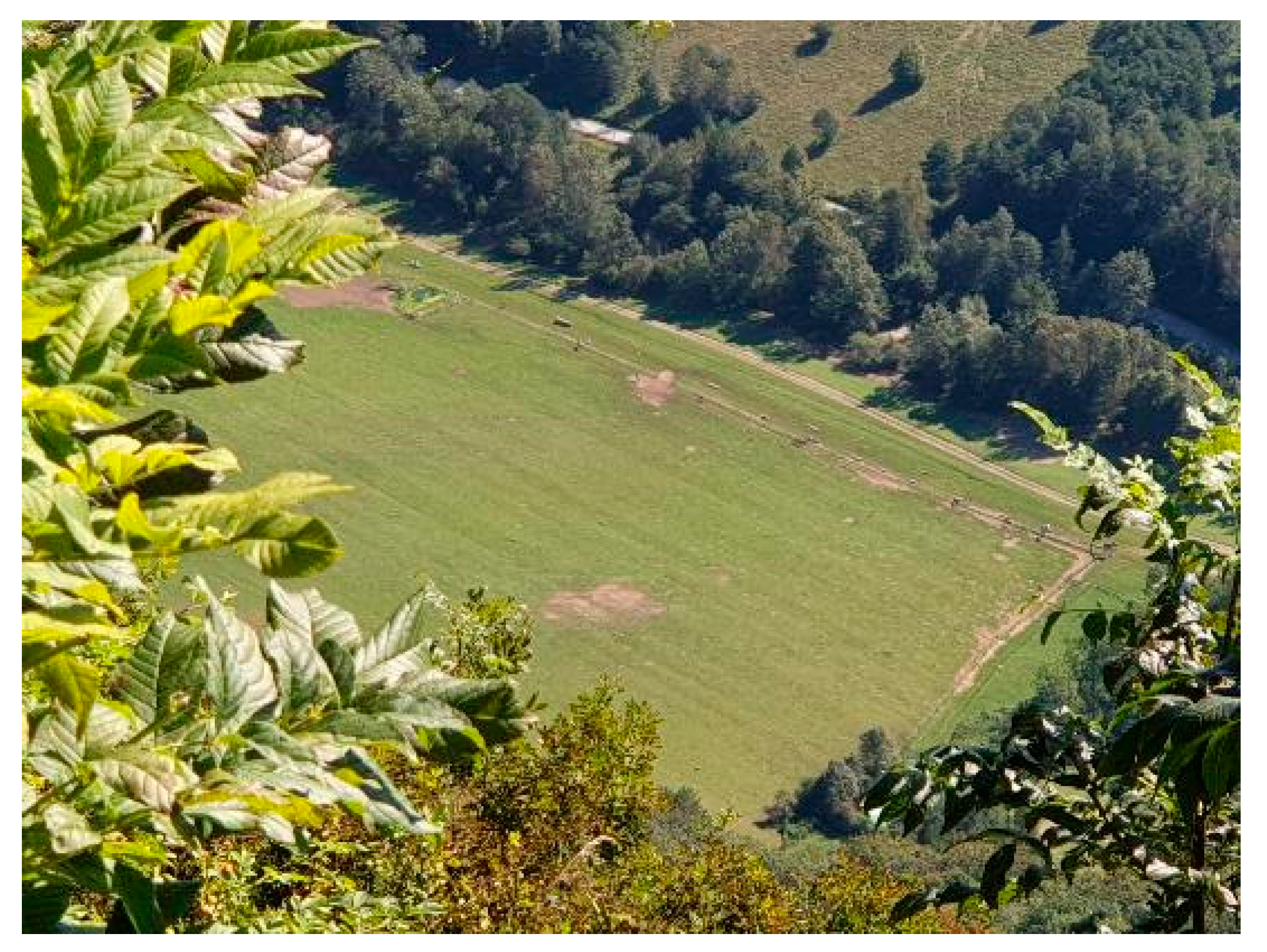
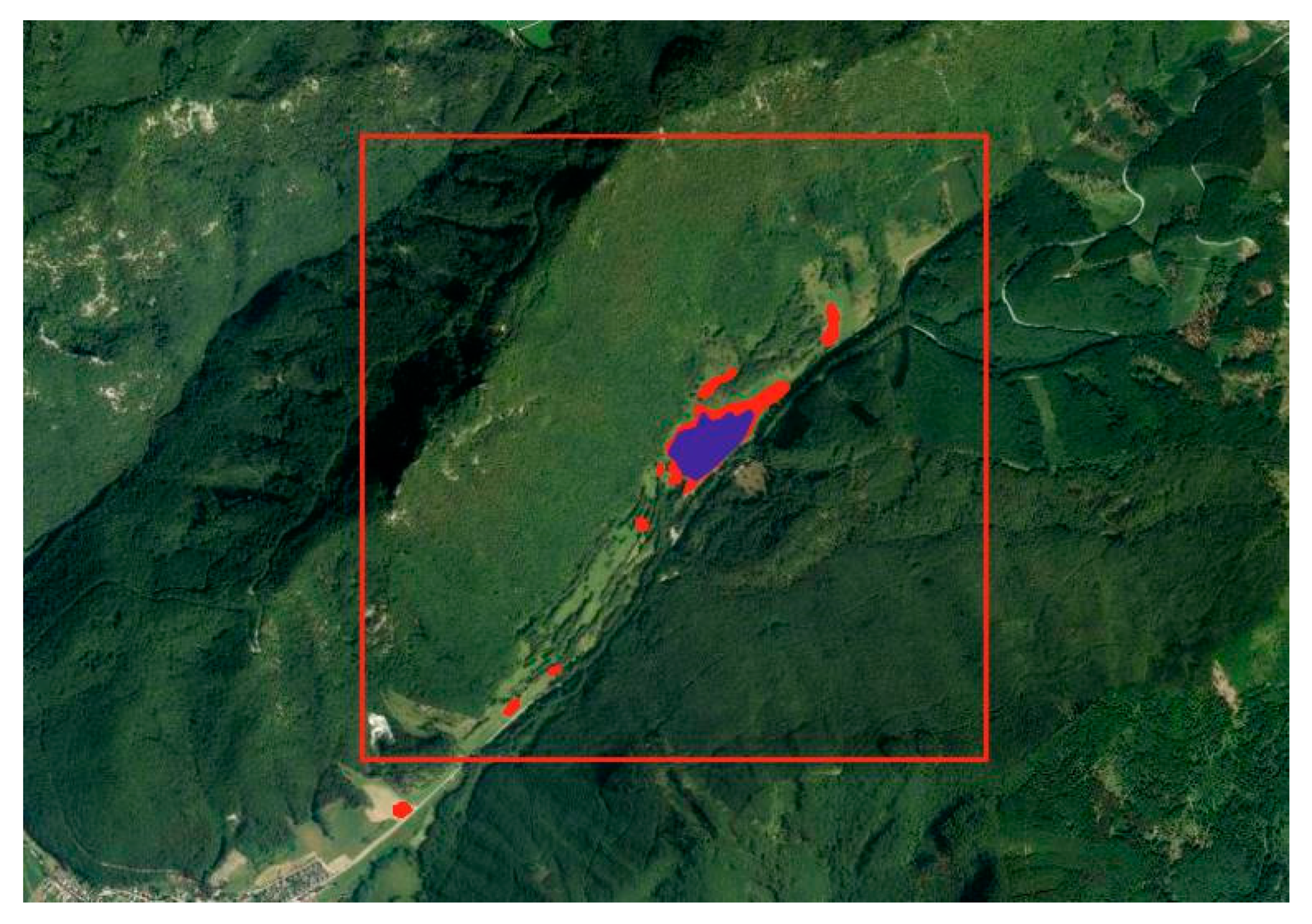
4.2. Conservation Translocation of European Ground Squirrel in the Locality Biele Vody
5. Discussion
6. Conclusions
Author Contributions
Funding
Data Availability Statement
Conflicts of Interest
Appendix A


References
- Spitzenberger, F.; Bauer, K. Ziesel Spermophilus citellus (Linnaeus, 1766). In Die Säugetierfauna Ősterreichs. Grüne Reihe des Bundesministeriums für Land- und Forstwirtschaft; Spitzenberger, F., Ed.; Umwelt und Wasserwirtschaft: Vienna, Austria, 2001; pp. 356–365. [Google Scholar]
- Kordos, L. Evolution of the holocene vertebrate fauna in the Carpathian Basin. Z. Geol. 1982, 10, 963–970. [Google Scholar]
- Kryštufek, B. Spermophilus citellus (Linnaeus, 1766). In The Atlas of European Mammals; Mitchell-Jones, A.J., Ed.; Academic Press: London, UK, 1999; pp. 190–191. [Google Scholar]
- Kryštufek, B.; Vohralík, V. Mammals of Turkey and Cyprus. Rodentia I: Sciuridae, Dipodidae, Gliridae, Arvicolinae; Zgodovinsko Društvo za Južno Primorsko: Ljubljana, Slovenia, 2005; pp. 42–43. [Google Scholar]
- Coroiu, C.; Kryštufek, B.; Vohralík, V.; Zagorodnyuk, I. Spermophilus citellus. In IUCN 2012, IUCN Red List of Threatened Species 2008; IUCN: Gland, Switzerland, 2008; Available online: https://www.iucnredlist.org/species/20472/9204055 (accessed on 8 January 2023).
- Janák, M.; Marhoul, P.; Matějů, J. Action Plan for the Conservation of the European Ground Squirrel Spermophilus citellus in the European Union; European Commission: Brussels, Belgium, 2013; pp. 5–8. [Google Scholar]
- Ramos-Lara, N.; Koprowski, J.L.; Kryštufek, B.; Hoffmann, I.E. Spermophilus citellus (Rodentia: Sciuridae). Mammal. Species 2014, 46, 71–87. [Google Scholar] [CrossRef]
- Hoffmann, I.E.; Millesi, E.; Huber, S.; Everts, L.G.; Dittami, J.P. Population dynamics of European ground squirrels (Spermophilus citellus) in a suburban area. J. Mammal. 2003, 84, 615–626. [Google Scholar] [CrossRef]
- Ružić, A. 1978: Citellus citellus (Linnaeus, 1766)—Der Oder das Europäische Ziesel. In Handbuch der Säugetiere Europas. Bd. 1, Nagetiere I (Sciuridae, Castoridae, Gliridae, Muridae); Niethammer, J., Krapp, F., Eds.; Akademische Verlagsgesellschaft: Wiesbaden, Germany, 1978; pp. 123–144. [Google Scholar]
- Hegyeli, Z. Spermophilus citellusi, IUCN Red List Threatment Species. 2020. Available online: https://www.iucnredlist.org/species/20472/91282380 (accessed on 19 February 2023).
- Hoffmann, I.E.; Millesi, E.; Pieta, K.; Dittami, J.P. Anthropogenic effects on the population ecology of European ground squirrels (Spermophilus citellus) at the periphery of their geographic range. Mammal. Biol. 2003, 68, 205–213. [Google Scholar] [CrossRef]
- Krištofík, J. Syseľ obyčajný (pasienkový)—Spermophilus citellus. In Cicavce Slovenska, Rozšírenie, Bionómia a Ochrana; Krištofík, J., Danko, Š., Eds.; Veda, vydavateľstvo SAV: Bratislava, Slovakia, 2012; pp. 58–62. [Google Scholar]
- Rana, W.A.; Hong, S.; Andaleeb, Y.; Asif, S.; Syed, Z.U.A. Identification of time-varying wetlands neglected in Pakistan through remote sensing techniques. Environ. Sci. Pollut. Res. 2003, 30, 74031–74044. [Google Scholar]
- Wang, Y.; Huang, C.; Feng, Y.; Zhao, M.; Gu, J. Using Earth Observation for Moni-toring SDG 11.3.1-Ratio of Land Consumption Rate to Population Growth Rate in Mainland China. Remote Sens 2020, 12, 357. [Google Scholar] [CrossRef]
- Vološčuk, I.; Pelikán, V. (Eds.) Muránska Planina: Chránená Krajinná Oblast; Obzor: Bratislava, Slovakia, 1991. [Google Scholar]
- Kolejka, J. Czech Experience with Land Use and Land Cover Change Research. In Land Use/Land Cover Changes in the Period of Globalization: Proceedings of the IGU-LUCC International Conference; Bičík, I., Chromý, P., Jančák, V., Janů, H., Eds.; Charles University: Prague, Czech Republic, 2002; pp. 144–152. [Google Scholar]
- Gobin, A.; Campling, P.; Feyen, J. Logistic modelling to derive agricultural land use determinants: Case study from southeastern Nigeria. Agric. Ecosyst. Environ. 2002, 89, 213–228. [Google Scholar] [CrossRef]
- Kuplich, T.M.; Freitas, C.C.; Soares, J.V. The study of ERS-1 SAR and Landsat TM synergism for land use classification. J. Remote Sens. 2000, 21, 2101–2111. [Google Scholar] [CrossRef]
- Boltižiar, M.; Olah, B. Land-Use Changes in the Selected Part of the Tatry Biosphere Reserve in 1772–2003. In Nauka a Zarządzanie Obszarem Tatr i ich Otoczeniem; Tom I: Zakopane, Poland, 2010; pp. 27–39. [Google Scholar]
- Munteanu, C.; Kuemmerle, T.; Boltižiar, M.; Lieskovský, J.; Mojses, M.; Kaiim, D.; Konkolygyuro, E.; Mackovcin, P.; Müller, D.; Ostapowicz, K.; et al. 19th century land-use legacies affect contemporary land abandonment in the Carpathians. Reg. Environ. Chan. 2017, 17, 2209–2222. [Google Scholar] [CrossRef]
- Bezák, P.; Izakovičová, Z.; Miklós, L.; Šatalová, B.; Petrovič, F.; David, S.; Boltižiar, M. Reprezentatívne Typy Krajiny Slovenska; Ústav Krajinnej Ekológie Slovenskej Akadémie Vied: Bratislava, Slovakia, 2010. [Google Scholar]
- Köhler, R.; Olschofsky, K.; Gerard, F. Land Cover Change in Europe from the 1950′ies to 2000; Institute for Worldforestry, University of Hamburg: Hamburg, Germany, 2004. [Google Scholar]
- Chrastina, P.; Trojan, J.; Župčán, L.; Tuska, T.; Hlásznik, P.P. Land use ako nástroj revitalizácie krajiny na príklade slovenskej exklávy Tardoš (Maďarsko). Geogr. Cassoviensis 2019, 13, 121–140. [Google Scholar]
- Chrastina, P.; Hronček, P.; Gregorová, B.; Žoncová, M. Land-use changes of historical rural landscape—Heritage, protection, and sustainable ecotourism: Case study of Slovak exclave Čív (Piliscsév) in Komárom-Esztergom County (Hungary). Sustainability 2020, 12, 6048. [Google Scholar] [CrossRef]
- Boltižiar, M.; Chrastina, P.; Trojan, J. Vývoj využívania kultúrnej krajiny slovenskej enklávy Šára v Maďarsku (1696–2011). Geogr. Inf. 2016, 20, 24–37. [Google Scholar]
- Chrastina, P. Krajina Veľkého Bánhedeša a jej Premeny. In Acta Nitriensiae 10; Gadušová, Z., Ed.; FF UKF: Nitra, Slovakia, 2008; pp. 74–94. [Google Scholar]
- Chrastina, P. Zmeny Využívania Krajiny Békešskej Čaby. In Kapitoly z Minulosti a Súčasnosti Slovákov v Békešskej Čabe; Kmet’, M., Tušková, T., Uhrinová, A., Eds.; Magyarországi Szlovákok Kutatóintézete: Békešská Čaba, Hungary, 2018; pp. 378–401. [Google Scholar]
- Chrastina, P.; Boltižiar, M. Butín: Krajina-človek-kultúra slovenskej enklávy v rumunskom Banáte. Stud. Hist. Nitriensia 2008, 14, 165–193. [Google Scholar]
- Chrastina, P.; Boltižiar, M. Senváclav: Krajina-Človek-Kultúra Slovenskej Enklávy vo Vyšegrádskych Vrchoch. Stud. Hist. Nitriensia 2010, 15, 53–86. [Google Scholar]
- Chrastina, P. Príbehy Krajín Minulosti; Univerzita Cyrila a Metoda v Trnave: Trnava, Slovakia, 2023. [Google Scholar]
- Chrastina, P.; Křováková, K.; Brůna, V. Zmeny krajiny v rumunskom Bihore (na príklade slovenskej exklávy Borumlak a Varzaľ). Hist. Geogr. 2007, 32, 371–398. [Google Scholar]
- Hendl, J.; Remr, J. Metody Výzkumu a Evaluace; Portál: Praha, Czech Republic, 2017. [Google Scholar]
- Ochrana, F. Metodologie, Metody a Metodika Vědeckého Výzkumu; Karolinum: Praha, Czech Republic, 2019. [Google Scholar]
- Gomez, B.; Jones, J.P. Research Methods in Geography: A Critical Introduction; Wiley-Blackwell: Chichester, UK, 2010. [Google Scholar]
- Hronček, P. Možnosti využitia interdisciplinárnych výskumných metód v histórii, pri výskume historickej krajiny a historických krajinných prvkov. Zborník Kysuc. Múzea 2014, 16, 21–64. [Google Scholar]
- Claus, P.; Marriott, J. History: An Introduction to Theory, Method and Practice, 2nd ed.; Taylor & Francis Group: London, UK, 2017. [Google Scholar]
- Semotanová, E.; Chromý, P.; Kučera, Z. Historická Geografie. Tradice a Modernita; Historický Ústav ČAV Praha: Prague, Czech Republic, 2018. [Google Scholar]
- Hronček, P.; Gregorová, B. Fundamentálna charakteristika vedeckého výskumu v historickej geografi. Geogr. Štúdie 2022, 15, 8–28. [Google Scholar]
- Krištofičová, E. Prostriedky Hodnotenia Knižničných a Vedeckoinformačných Procesov; CVTI: Bratislava, Slovakia, 1997. [Google Scholar]
- Carrizo-Sainero, G. Toward a Concept of Bibliometrics. J. Span. Res. Inf. Sci. 2000, 1, 59–86. [Google Scholar]
- Ondrišová, M. Bibliometria; Stimul: Bratislava, Slovakia, 2011. [Google Scholar]
- Hronček, P.; Jakubík, J. Možnosti Interpretácie Veľkomierkových Historických Máp pri Výskume Miestnej Krajiny. In Studie z Dějin Geodézie a Kartografie; Národní Technické Muzeum v Praze: Praha, Czech Republic 2011, 15, pp. 23–28. [Google Scholar]
- Boltižiar, M.; Olah, B. Potenciál historických máp a leteckých snímok pri štúdiu zmien krajiny. Geogr. Rev. 2008, 4, 64–82. [Google Scholar]
- Boltižiar, M.; Olah, B. Krajina a Jej Štruktúra (Mapovanie, Zmeny a Hodnotenie); UKF v Nitre, Fakulta Prírodných Vied: Nitra, Slovakia, 2009. [Google Scholar]
- Maglocký, Š. Potenciálna Prirodzená Vegetácia 1:500,000. In Atlas Krajiny S.; Ministerstvo Životného Prostredia SR: Bratislava, Slovakia, 2002; pp. 114–115. [Google Scholar]
- Butlin, R.A.; Dodgshon, R.A. An Historical Geography of Europe; Oxford University Press: Oxford, UK, 1998. [Google Scholar]
- Chrastina, P. Historická geografia na Slovensku: Minulost’, súčasnost’ a perspektívy. Hist. Geogr. 2004, 33, 420–432. [Google Scholar]
- Hronček, P.; Urban, P.; Gregorová, B.; Čech, V.; Tometzová, D. Anthropogenically Created Alpine Pastures as Landscape Resources for the Alpine Chamois Population in the Western Carpathians Mountain Range: Ďumbier Tatras Case Study. Land 2022, 11, 2177. [Google Scholar] [CrossRef]
- Hronček, P.; Gregorová, B. Historická Geografia: Antropogénne Transformácie a Využívanie Vodných Tokov v doline Hrona Východne od Banskej Bystrice; Katedra Geografie a Geológie FPV UMB: Banská Bystrica, Slovakia, 2022. [Google Scholar]
- Best, W.J.; Kahn, V.J. Research in Education. In Historical Research, 8th ed.; Chapter IV; Allyn and Bacon: Boston, MA, USA, 1998; pp. 77–112. [Google Scholar]
- Gerber, E.W. Methodology in Historical Research. Exerc. Sport Sci. Rev. 1974, 2, 335356. [Google Scholar] [CrossRef]
- Semotanová, E. Historická Geografie Českých Zemí; Historický Ústav AV ČR: Prague, Czech Republic, 2002. [Google Scholar]
- Žigrai, F. Význam Časopriestoru pri Transformácii Kultúrnej Krajiny (Vybrané Teoreticko—Metodologické Aspekty). Geogr. Štúdie 1999, 6, 51–60. (In Slovak) [Google Scholar]
- Efroymsone, R.A.; Klinea, K.L.; Angelsenb, A.; Verburgc, P.H.; Dalea, V.H.; Langeveldd, J.W.; McBridea, A. A causal analysis framework for land-use change and the potential role of bioenergy policy. Land Use Policy 2016, 59, 516–527. [Google Scholar] [CrossRef]
- Meyfroidt, P. Approaches and terminology for causal analysis in land systems science. J. Land Use Sci. 2016, 11, 501–522. [Google Scholar] [CrossRef]
- Blij, H.J.; Murphy, A.B. Human Geography, 6th ed.; John Willey & Sons: New York, NY, USA, 1999. [Google Scholar]
- Rodríguez-Rodríguez, D.; Martínez-Vega, J.; Echavarría, P. A twenty year GIS-based assessment of environmental sustainability of land use changes in and around protected areas of a fast developing country: Spain. Int. J. Appl. Earth Obs. Geoinf. 2019, 74, 169–179. [Google Scholar] [CrossRef]
- Pontius, R.G.; Shusas, E.; McEachern, M. Detecting important categorical land changes while accounting for persistence. Agric. Ecosyst. Environ. 2004, 101, 251–268. [Google Scholar] [CrossRef]
- Demek, J. Úvod do Štúdia Teoretickej Geografie; SPN: Bratislava, Slovakia, 1987. (In Slovak) [Google Scholar]
- Krippel, E. Postglaciálny Vývoj Vegetácie na Slovensku; VEDA: Bratislava, Slovakia, 1986. [Google Scholar]
- Michalko, J.; Magic, D.; Berta, J. Geobotanická Mapa ČSSR, Slovenská Socialistická Republika—List Brezno; VEDA: Bratislava, Slovakia, 1985. [Google Scholar]
- Michalko, J.; Magic, D.; Berta, J. Geobotanická Mapa ČSSR, Slovenská Socialistická Republika—Textová Časť; VEDA: Bratislava, Slovakia, 1986. [Google Scholar]
- Korpeľ, Š. Pralesy Slovenska; VEDA: Bratislava, Slovakia, 1989. [Google Scholar]
- Marsina, R. (Ed.) Codex Diplomaticus et Epistolaris Slovaciae II. č. 130; Obzor: Bratislava, Slovakia, 1987. [Google Scholar]
- Sarusi Kiss, B. A Természet Által Megerősített vár: Murány Végvár és Uradalma a 16. Század Második Felében; Budapest Főváros Levéltára: Budapest, Hungary, 2008. [Google Scholar]
- Skalská, M. Jelšava a Jelšavské Panstvo; K Osídleniu Severného Gemera Vydavateľstvo Matice Slovenskej: Martin, Slovakia, 2009. [Google Scholar]
- Wenzel, G. (Ed.) Codex Diplomaticus Arpadianus Continuatus. Árpád-kori új Okmánytár VIII. č. 225; Jókai Mór Városi Könyvtár: Pest, Hungary, 1870. [Google Scholar]
- Sedlák, V. (Ed.) Regesta Diplomatica nec non Epistolaria Slovaciae. č. 737, Tomus II. Inde ab a. MCCCXV ad a. MCCCXXIII; Academia Scientarum Slovaca: Bratislava, Slovakia, 1987. [Google Scholar]
- Ila, B. Gömör Megye III; A Magyar Tudományos Akadémia Kiadása: Budapest, Hungary, 1946. [Google Scholar]
- Hlodák, P.; Žilák, J. Panstvo Muráň, Hospodárske Dejiny; Kermat: Kalinovo, Slovakia, 2006. [Google Scholar]
- Keleti, G. Murányvár romjai. Vasárnapi Újság 1866, 13, 11. [Google Scholar]
- Hapl, E. Reštitúcia sysľa na Muránskej planine. Reussia 2006, 3, 153. [Google Scholar]
- Uhrin, M.; Benda, P.; Ambros, M.; Baláž, I.; Dudich, A.; Hapl, E.; Reiter, A.; Stollmann, A. K faune hmyzožravcov (Erinaceomorpha, Soricomorpha) a hlodavcov (Rodentia) Národného parku Muránska planina a blízkeho okolia (stredné Slovensko). Lynx 2009, 40, 95–114. [Google Scholar]
- Hapl, E.; Ambros, M.; Olekšák, M.; Adamec, M. 2006: Suslik (Spermophilus citellus) Reintroduction in Slovakia. Guidelines. State Nature Conservancy of the Slovak Republic, Banská Bystrica. Available online: https://www.dravce.sk/web/index.php?lang=sk (accessed on 19 February 2023).
- Danilák, M.; Kochjarová, J.; Ujházy, K. Vplyv reštituovanej populácie sysľa pasienkového (Spermophilus citellus L.) na vegetáciu—Prípadová štúdia z Muránskej planiny. Ochr. Prírody 2020, 36, 103–114. [Google Scholar]
- Hapl, E.; Löbbová, D. Syseľ, Biele Vody—Tipy a Triky v Manažmente. In Proceedings of the Manažment Ekosystémov v Prizme Nerovnovážnej Perspektívy, Banská Bystrica, Slovakia, 21 November 2018. [Google Scholar]
- Bóna, M.; Tihányiová, M. Najstaršie vyobrazenie hradu Muráň. Pamiat. A Múzeá 2015, 2, 6–7. [Google Scholar]
- Frák, G. Hrad Muráň, a jeho alódia s podanské obce v roku 1670. Obz. Gemera-Malohontu 1991, 22, 21–27. [Google Scholar]
- Da Assunção Araújo, M. Climatic and Coastal Evolution during Little Ice Age: Some Considerations. In European Seaport Systems in the Early Modern Age—A Comparative Appriach; 2007; pp. 79–88. Available online: https://repositorio-aberto.up.pt/bitstream/10216/23223/2/assuncaoaraujoclimatic000093974.pdf (accessed on 10 May 2023).
- Podolska, K. Jak sluneční aktivita ovlivňuje Zemi a prostředí pro lidskou populaci. Hist. Demogr. 2014, 2, 127–155. [Google Scholar]
- Niedźwiedź, T. Rekonstrukcja WARUNKÓW Termicznych Lata w Tatrach od 1550 Roku. In Rola Malej Epoki Lodowej w Przeksztalcaniu Środowiska Przyrodniczego Tatr; Inst. Geografii i Przestrzennego Zagospodarowania: Warszawa, Poland, 2004; pp. 57–88. [Google Scholar]
- Jesenský, M.; Hronček, P.; Polčák, N. The effects of weather extremes on the agriculture in Northern Hungary during the Maunder Minimum. Meteorol. Zprávy 2020, 73, 46–52. [Google Scholar]
- Kyseľová, E. Zhodnotenie Reštitúcie Sysľa Pasienkového (Spermophilus citellus L.) v Národnom Parku Muránska Planina: Diplomová práca; Technická Univerzita vo Zvolene: Zvolen, Slovakia, 2010. [Google Scholar]
- Obuch, J. Osteologické nálezy z Muránskej planiny. Stred. Slov. (Prírodné Vedy) 1985, 4, 160–193. [Google Scholar]
- Obuch, J. Podhorský typ Potravy výra Skalného (Bubo bubo) na Horehroní. In Výskum a Ochrana Prírody Muránskej Planiny 3; Uhrin, M., Ed.; Správa NP Muránska Planina: Revúca, Slovakia, 2002; pp. 163–169. [Google Scholar]
- Hanák, V.; Anděra, M. Drobní savci Muránskej planiny (Slovenské rudoroří). Časopis Národního Muz. (Přírodní Vědy) 1980, 149, 39–47. [Google Scholar]
- Wiezik, M.; Niňajová, I.; Švajda, J.; Elexová, Ľ. Koncept Prírodného Turizmu v Slovenských Podmienkach; Aevis n. o.: Snina, Slovakia, 2019. [Google Scholar]


| Authors | Type of Research | Study Area/Country |
|---|---|---|
| J. Kolejka (2002) [16] | Landscape changes of water reservoir | Nové Mlýny in the Czech Republic |
| A. Gobin, P. Campling with J. Feyen (2002) [17] | Agricultural land use aspects of the town | Ikem in southeastern Nigeria |
| T. Kuplich, C. Freitas and J. Soares (2000) [18] | Land use classification of the town | Campinas in Brazil |
| M. Boltižiar, B. Olah (2010) [19] | Historical land use changes in the biosphere reserve | Tatras in Slovakia |
| C. Munteanu, T. Kuemmerle, M. Boltižiar, J. Lieskovský, M. Mojses, D. Kaiim, E. Konkolygyuro, P. Mackovcin, D. Müller, K. Ostapowicz, V. C. Radeloff (2017) [20] | 19th-century land-use legacies and contemporary land abandonment | Carpathians/Europe |
| P. Bezák, Z. Izakovičová, L. Miklós et al. (2010) [21] | Representative landscape types of country | Slovakia |
| R. Köhler, K. Olschofsky, F. Gerard (2004) [22] | Historical land cover changes in European countries | Europe |
| P. Chrastina, J. Trojan, L. Župčán, T. Tuska, P. P. Hlásznik (2019) [23] | Land use and landscape revitalization | Slovak exclave Tardoš in Hungary |
| P. Chrastina, P. Hronček, B. Gregorová, M. Žoncová (2020) [24] | Land use changes in the historical rural landscape | Slovak exclave Čív (Piliscsév) in Hungary |
| M. Boltižiar, P. Chrastina, J. Trojan (2016) [25] | Land use development of cultural landscape | Slovak exclave Sári in Hungary |
| P. Chrastina (2008) [26] | Land use changes in the cultural landscape | Slovak exclave Nagybánhegyes in Hungary |
| P. Chrastina (2018) [27] | Land use changes in the cultural landscape | Békéscsaba in Hungary |
| P. Chrastina, M. Boltižiar (2008) [28] | Development of cultural landscape | Slovak exclave Butin in Romania |
| P. Chrastina, M. Boltižiar (2010) [29] | Land use changes in the cultural landscape | Slovak exclave Senváclav in Hungary |
| P. Chrastina, J. Trojan, L. Župčán, T. Tuska, P. P. Hlásznik (2019) [30] | Land use as a tool for landscape revitalization | Slovak exclave Tardoš in Hungary |
| P. Chrastina, K. Křováková, V. Brůna (2007) [31] | Changes in the cultural landscape | Slovak exclaves Borumlak a Varzaľ in Romania |
| Level 1 | Level 2 | Level 3 |
|---|---|---|
| 1 Artificial surfaces | 1.1 Urban fabric | Castle |
| 2 Agricultural areas | 2.1 Arable land | 2.1.1 Nonirrigated arable land |
| 2.3 Pastures | 2.3.1 Pastures | |
| 3 Forest and seminatural areas | 3.1 Forests | 3.1.3 Mixed forest |
| 3.2 Shrub and/or herbaceous vegetation associations | Shrub | |
| 3.2.4 Transitional woodland/shrub |
| Type of Map | Castle | Nonirrigated Arable Land | Pastures | Mixed Forest | Shrub | Transitional Woodland-Shrub |
|---|---|---|---|---|---|---|
| I. Military mapping from the 1780s of the 18th century | 6 | 38 | 134 | 442 | 0 | 6 |
| II. military mapping from the 1860s of the 19th century | 5 | 45 | 140 | 429 | 0 | 6 |
| Aerial photograph from 1950 | 0 | 43 | 82 | 484 | 5 | 11 |
| CORINE land cover from 2018 | 1 | 0 | 68 | 540 | 0 | 16 |
Disclaimer/Publisher’s Note: The statements, opinions and data contained in all publications are solely those of the individual author(s) and contributor(s) and not of MDPI and/or the editor(s). MDPI and/or the editor(s) disclaim responsibility for any injury to people or property resulting from any ideas, methods, instructions or products referred to in the content. |
© 2023 by the authors. Licensee MDPI, Basel, Switzerland. This article is an open access article distributed under the terms and conditions of the Creative Commons Attribution (CC BY) license (https://creativecommons.org/licenses/by/4.0/).
Share and Cite
Gregorová, B.; Hronček, P.; Urban, P. An Anthropogenically Created Landscape as a Habitat for the European Ground Squirrel Population Using the Example of the Muránska Planina National Park in the Western Carpathians (Slovakia). Land 2023, 12, 2070. https://doi.org/10.3390/land12112070
Gregorová B, Hronček P, Urban P. An Anthropogenically Created Landscape as a Habitat for the European Ground Squirrel Population Using the Example of the Muránska Planina National Park in the Western Carpathians (Slovakia). Land. 2023; 12(11):2070. https://doi.org/10.3390/land12112070
Chicago/Turabian StyleGregorová, Bohuslava, Pavel Hronček, and Peter Urban. 2023. "An Anthropogenically Created Landscape as a Habitat for the European Ground Squirrel Population Using the Example of the Muránska Planina National Park in the Western Carpathians (Slovakia)" Land 12, no. 11: 2070. https://doi.org/10.3390/land12112070