Article

Multiresource Pastoralism, Dynamic Foodways, and Ancient Statecraft in Mongolia

by
William Honeychurch
1,*,
Chunag Amartuvshin
2,
Joshua Wright
3,
Christina Carolus
1 and
Michelle Hrivnyak
4
1
Department of Anthropology, Yale University, New Haven, CT 06520, USA
2
Department of Anthropology and Archaeology, National University of Mongolia, Ulaanbaatar 14200, Mongolia
3
Department of Archaeology, University of Aberdeen, Aberdeen AB24 3UF, UK
4
Institute for Intercultural and Anthropological Studies, Western Michigan University, Kalamazoo, MI 49008, USA
*
Author to whom correspondence should be addressed.
Land 2023, 12(9), 1715; https://doi.org/10.3390/land12091715
Submission received: 10 July 2023 / Revised: 9 August 2023 / Accepted: 12 August 2023 / Published: 2 September 2023
(This article belongs to the Special Issue Modeling Land Use Change Using Historical and Archaeological Datasets)

Abstract

:
Pastoral nomadic regional confederations, states, and empires have assumed a prominent place in the histories of the Eurasian steppe zone; however, anthropological theory devoted to understanding these political systems is still debated and relatively inchoate. A major question concerns the techniques of political integration that might have brought together dispersed mobile herders under the aegis of these complex, large-scale steppe polities. The first such polity in East Asia, the Xiongnu state (c. 250 BC–150 AD) of Mongolia, has been characterized as a polity built by mobile herders, but in fact the steppe populations of this period followed quite diverse lifeways. Most notably, the establishment of more permanent settlements for craft and agricultural production has complicated the typical narrative of the pastoral nomadic eastern steppe. This study considers ways to conceptualize these interesting variations in lifeway during the Xiongnu period and raises the question of how they might have promoted a novel Xiongnu political order. We analyze transformations within the Egiin Gol valley of northern Mongolia to better understand the organizational, productive, and settlement dynamics and present the first regional landscape perspective on the local transformations incurred by the creation of a Xiongnu agricultural hub. To understand these radical changes with respect to the long-term pastoral nomadic and hunting-gathering traditions of the valley’s inhabitants, Salzman’s flexibility-based model of multiresource pastoralism is of great use. Egiin Gol valley transformations indeed attest to a scale of political economy far beyond the bounds of this local area and suggest an innovative role for indigenous farming in Eurasian steppe polity building.

1. Introduction

Archaeologists depend on the making of typology, but when it comes to human lifeways, typology has a propensity to fails us. Intricate webs of ‘this or that’ and ‘is or isn’t’ have long ensnared academic debates over prehistory, and none more so than in the case of the ancient pastoral nomad [1,2,3,4]. How many times must a household move before we call them nomadic and how many sheep must farmers keep before they transform into herders? Questions like these rarely have definitive or even agreed-upon answers, resulting in endless deliberation; but even more problematically, they may lead us to miss the anthropological point entirely [5]. What if the expertise of pastoral nomadic peoples is not merely in animals and movement per se, but in the social and cultural flexibility that a joining of human and animal communities inspires? For more than 40 years, these kinds of questions about pastoral nomadic lifeways have concerned anthropologists working in regions around the world where mobile herders are present and prominent [6,7]. Ideally, our need for categorization should not diminish sight of the dynamism, diversity, and implicit variability that made up the socio-cultural landscapes of early pastoral nomadic peoples—who, indeed, may have been specialists in change rather than stasis [8,9].
Archaeologists researching the Inner Asian past have increasingly documented and grappled with evidence for such flexible and complex adaptations, characterized by modulations in subsistence pursuits, settlement patterns, and mobility—all of which seem to be part and parcel of what pastoral nomads once did and still do. Inhabitants of the eastern Eurasian steppe have long practiced subsistence strategies that developed over time and were uniquely attuned to both localized factors and a propensity for change. Among these local factors we include common environmental variables such as resource distribution, temperature, precipitation and so forth, but also recognize the critical importance of social and political contexts. If indeed pastoral communities were particularly adept at adjusting for changing circumstances, then social and political changes were probably a primary consideration for modulation in local practices. Over time, we might expect shifts in subsistence emphasis and resource combinations, ranges of mobility, reorientation of exchange networks, and the innovation or adoption of new technologies, as part of an integrated and malleable pastoralism [10,11,12]. This latter approach to understanding Eurasian herding is also known as multiresource pastoralism and makes room for the variable inclusion of farming, hunting, foraging, craft production, trade specializations, and more—all tied into a tradition attuned to herd animals and movement as a flexible core [13,14]. Multiresource pastoralism seeks to enfranchise thinking on mobile herding adaptations from a dynamic, diachronic, and decidedly non-typological perspective. In short, the concept seeks to treat process as opposed to description (e.g., [15]).
The multiresource model is particularly relevant for today’s Eurasian steppe archaeology. Innovative fieldwork and new analytical methods are complicating traditional narratives about pastoral nomadic subsistence strategies, revealing evidence for the use of cereal crops and varied farming practices among herding populations in Kazakhstan, southern Siberia, Mongolia, and Xinjiang among others [16,17]. Research interest in early cereal adoption across central and eastern Eurasia has expanded significantly in the last decade and has been accompanied by breakthroughs in deciphering histories of crop transmission, production, consumption, and subsistence combinations through time and over space [18,19,20]. The presence of wheat, barley, and millet in what have generally been considered typically ‘pastoral nomadic’ contexts has long been recognized by archaeologists, even if the dynamics of their presence were not fully understood [16,21,22]. Prior to the advent of Western botanical analysis in steppe archaeology, Soviet-period archaeologists had already developed substantial evidence for the consumption, storage, and farming of cereal crops in parts of the steppe region expected to have been home to mobile herding communities (e.g., [23]).
The latest research dramatically pushes back the antiquity of the earliest cereal evidence in these regions, in some cases to as early as the fourth millennium BC. It has expanded known geographical distributions of cereal crop species and documented a wide number of uses, including ritual purposes, as a subsistence supplement, as a source of animal fodder, as well as a major productive focus. Of great interest is the variable timing of cereal adoptions and impacts across Inner Asia. This variation raises important questions about the very different contexts of reception and possible reasons behind communal indifference or even resistance to the introduction of cereals in some cases (cf. [24,25]). Archaeology reveals disjuncture and dramatically different processes of uptake in sub-regions of the eastern steppe, and nowhere is this more apparent than on the Mongolian plateau. Across most of the territory of modern Mongolia, evidence for the integration of wheat, barley, and millet with local foodways seems to appear more than one thousand years after cereal crop adoptions in adjacent regions [26].
The reasons behind this striking variability are debated, and several hypotheses have been advanced, but so far few if any localized, in-depth studies of the introduction of ancient cereal crops have been carried out in Mongolia. Fewer yet have pondered the meanings and timing behind these introductions, or what they might have meant for the millennia-long tradition of pastoral lifeways practiced in the region. The present study explores the diachronic development of multiresource pastoral subsistence strategies in a discrete micro-region of Mongolia with an emphasis on evaluating changes in landscape organization potentially related to the emergence of agricultural practice. We turn to what is perhaps one of the most comprehensively studied areas of Mongolia, the Egin Gol valley (Figure 1), where two decades of survey, excavation, and analysis provide a substantial dataset of isotopic, faunal, archaeobotanical and survey evidence for the study of local transformations in lifeways. Our results demonstrate that the cereal crops of broomcorn millet (Panicum miliacium L.), wheat (Triticum sp.), and barley (Hordeum vulgare L.) experienced a major florescence in northern Mongolia during the onset of the Xiongnu state (third c. BC) and suggest that grain production and consumption had a specific political significance for state building among pastoral nomadic communities of early Mongolia. Our research follows a small number of isotopic studies that have advanced a similar hypothesis (e.g., [27]), but this is the first analysis from Mongolia to incorporate multiple lines of evidence to test these ideas and connect such changes with regional socio-political processes.

2. Cereal Grains in Mongolia—Background and Context

The timings, pathways, and conditions by which cereal grains arrived and were individually adopted across steppe communities remain somewhat obscure; however, evidence is building for the Inner Asian Mountain Corridor pathway as a major conduit for cereal introductions [28]. Some of the earliest documented grain crop evidence in the eastern steppe region appears in northwestern Xinjiang at the end of the fourth millennium BC [29], followed by the early to mid-third millennium BC in southeastern and eastern Kazakhstan [30,31,32,33], and the mid- to late second millennium BC in central and northern Kazakhstan and southern Siberia [34,35,36]. The cultigens in question are a combination of eastern and western domesticates and, when combined, make up a particularly resilient resource assemblage. This frost and drought tolerant C3/C4 package, consisting of wheats (Triticum sp.), barley (Hordeum vulgare L.), and millets (Panicum miliacium L. and Setaria italica L.) could abide a range of ecological constraints and first appears to coalesce as an eastern Eurasian cultivation package during the Bronze Age [19,37,38]. Currently, archaeological research in eastern Eurasia focuses most intently on exploring the spread of broomcorn and foxtail millets based on stable isotopic dietary research, since non-native C4 species can be indirectly attested through stable carbon isotope signals [35]. The earliest appearance of exotic C3 cereals such as barley and wheats so far has received much less attention.
This rapidly growing body of research reveals one major exception to an otherwise broad-based interregional adoption of cereal crops. Despite its presence in borderlands virtually circumscribing Mongolia, millets, wheat and barley seem to have arrived in this central part of the eastern steppe extraordinarily late in time [26,27,39,40,41]. So far, direct physical evidence for the existence of cereal grain on the Mongolian and Transbaikal steppe does not enter the archaeological record until the late first millennium B.C. during the Xiongnu period (c. 250 BC–150 AD). This geographical pattern was recognized only after the striking antiquity of cereals, particularly millets, in surrounding regions had been documented by archaeobotanical and absolute dating methods. In most areas adjacent to the Mongolian plateau, millets (and probably wheats and barley as well) had already been in use for a millennium or longer before their appearance in most parts of Mongolia. Only in the Altai Mountains, Tuva, and in a small corner of northwest Mongolia abutting Tuva do millets appear as late as the mid-first millennium BC [42,43,44]. Even in these far western regions, however, the earliest evidence for millet consumption still pre-dates Xiongnu evidence by three to five centuries [41,45,46].
The Xiongnu period in Mongolia is an intensively studied phase of nomadic state formation contemporaneous with the emergence of the Qin and Han states to the south. Although Han Dynasty historical texts provide some information about these political processes on the northern steppe [47], archaeology has added a great deal of new information, especially through study of mortuary and settlement contexts [48,49]. Cereal remains in burials of the Xiongnu period are documented as early as the 1920s [50,51] and since that time, macrobotanical evidence for wheat, millet, and barley has grown. Reports from royal Xiongnu mortuary complexes including Gol Mod I and II, Noyon Uul, and Takhiltyn Khotgor (Figure 1) note the occasional presence of offerings of millet [52,53,54,55]. Obata and Ishteren [56] examined seed casts taken from the external surface of ceramic vessels excavated from a selection of Xiongnu burials. These seeds were identified as unhulled broomcorn millet (Panicum miliacium L.) and were associated with vessels from six mortuary complexes in northern and central Mongolia. In addition to these Mongolian finds, the Xiongnu cemeteries of Cheryomukhovaia pad’ and Il’movaia pad’ in Transbaikal also have burials reported to contain cereals [53] (Figure 1).
The composition of cereal species reported during the Xiongnu period appears to be contextually linked, with recoveries from mortuary contexts showing a bias toward millets and with habitation sites linked to the presence of wheat and barley, or a combination of all three [26,55,57]. The presence of cereal cultigens and agricultural implements has been documented at a small number of settlement sites in northern Mongolia and Transbaikal. The Xiongnu walled settlement site of Ivolga just south of Lake Baikal is widely known for its reported assemblages of wheat, barley, and millets, as well as agricultural implements, grinding stones, and storage pits [58]. In north central Mongolia, the pit-house site of Boroogiin Suurin also has evidence of grinding stones and cereal grains [57,59]. Thus far, the only seasonal encampments of Xiongnu mobile pastoralists to provide archaeobotanical evidence of wheat, barley, and millet have been discovered in the Egiin Gol valley of northern Mongolia using systematic soil flotation methods [60,61].
Major questions to answer about this rather late appearance of cereal grains on the Mongolian plateau are why did foodways and productive strategies change at this time; what were the social and political contexts for these changes; and how do we understand such developments with reference to the mobile herding lifeways typically associated with the Xiongnu state? These are not new questions and have been debated by archaeologists and historians over the past 70 years (e.g., [62]). Hypotheses offered to account for grain finds in Xiongnu contexts have generally placed emphasis on a typological approach to nomadic pastoralism, seeing this lifeway as fundamentally inconsistent with indigenous farming practices [63]. Returning to the discussion of economic typology above, current archaeological evidence does not support such assumptions. Rather, the material record points us in more interesting directions emphasizing context, modulation, and variably expressed knowledge sets as key factors in the making of flexible lifeways. In fact, this penchant for flexibility among herders to engage in shifting multiresource production strategies and the suitability of many steppe environments for farming was recognized early on by scholars reviewing the ethnohistory of the eastern steppe (e.g., [43,64]). Today’s archaeologists working in Mongolia have built upon these ideas, favoring flexible adaptions to explain the growing evidence for cereal consumption and indigenous farming during the Xiongnu period as an adjunct to a long and varied tradition of mobile herding [8,39,61,65,66].
Among archaeologists, the Egiin Gol valley holds a special place in debates over Xiongnu agriculture and grain consumption due to the recovery of carbonized wheat and barley at seasonal herding campsites dated to the Xiongnu period [67]. Since no technological indicators of Xiongnu farming (e.g., grinding or threshing stones, plowing implements, etc.) were found in the valley, the provenance of these cereal grains was a matter of discussion. Grain from Han Dynasty tribute payments to the Xiongnu court could easily have been redistributed as political gifting to local powerholders, although in this case millet would have been the expected arrival. Another possibility might have been grain transfers from the known Xiongnu farming center at Ivolga in the Transbaikal region only a few hundred kilometers northeast of Egiin Gol. Both hypotheses were rejected by archaeologists working in the valley based on two observations: Egiin Gol is in the traditional ‘breadbasket’ of Mongolia’s dry-farmed agricultural sector and several Xiongnu period habitation sites have been recorded in or near contemporary plowed field plots [68,69,70]. Given this analogical evidence, a GIS analysis using low-resolution geographical data (e.g., 500 m NDVI) did indeed suggest that Xiongnu settlement was consistent with access to high quality farming locales [8].
Based on these preliminary results, the Egiin Gol project put forth two major hypotheses for the nature of grain agriculture in ancient Mongolia. The first advocates for multiresource pastoralism as an apt model for understanding the modulating emphasis between local herding, hunting-gathering, and presumed farming pursuits. The second hypothesis proposed a distinctly political role for grain production and transfers in the making of the Xiongnu state. This second idea has developed into a more detailed statement by virtue of results from subsequent fieldwork and analyses. We maintain that the Xiongnu period investment in cereal cultivation and consumption represented not an economic necessity but the purposeful creation of products that demarked and symbolized a novel emergent elite social order—an early politics of food contributing to an elite cuisine [24,71]. The regional circulation of such politically symbolic products related to local food preparation and diets may have acted as a method of integrative practice, especially good at marking socio-political distinctions within local communities where grain production was less viable, e.g., the arid regions of the Gobi Desert [26,39]. In this study, we test the first hypothesis using updated methods and data with an eye to what confirmation of this proposal means for the second hypothesis, especially in the context of recent studies on the Xiongnu period Gobi Desert communities to the south of Egiin Gol.

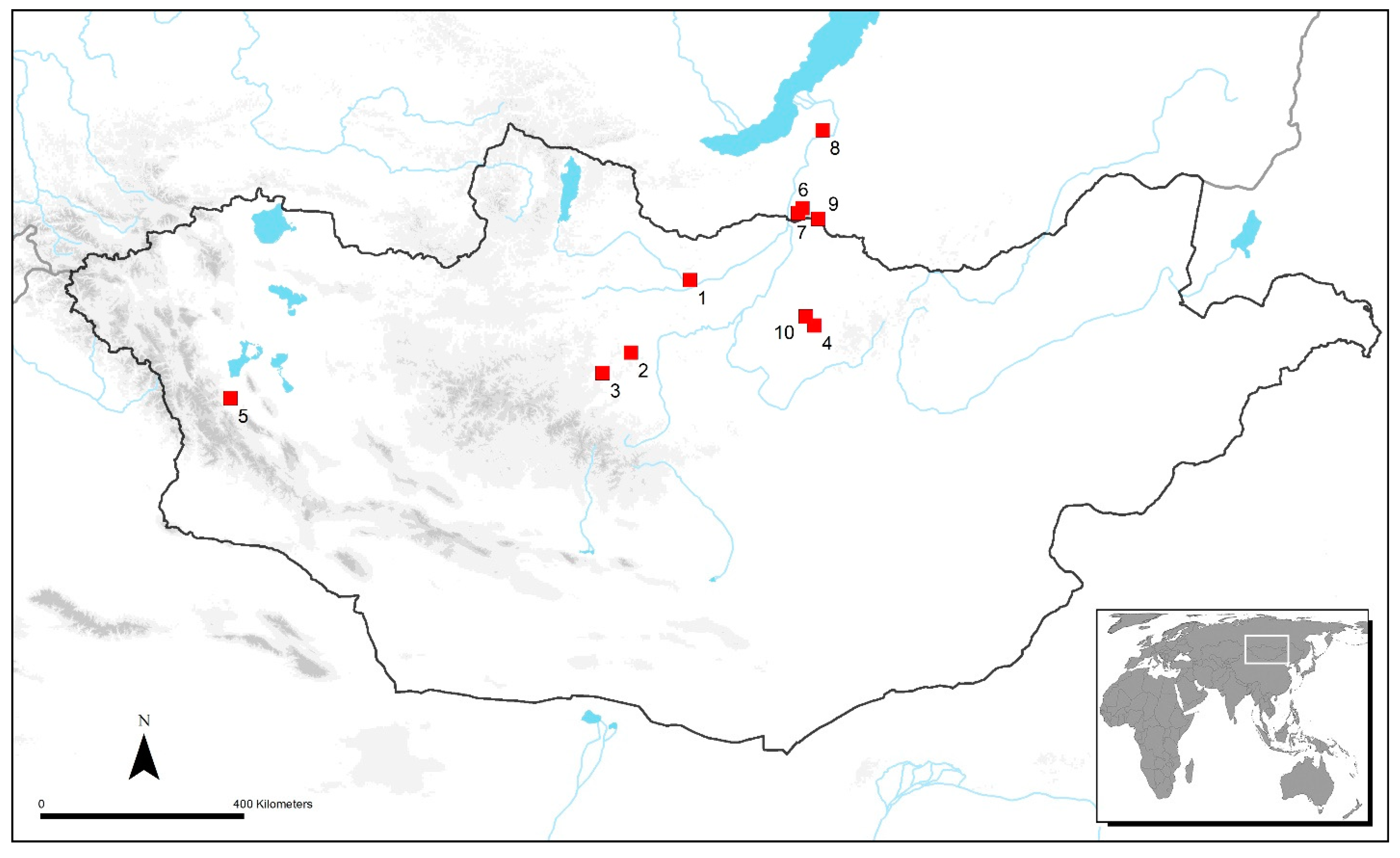
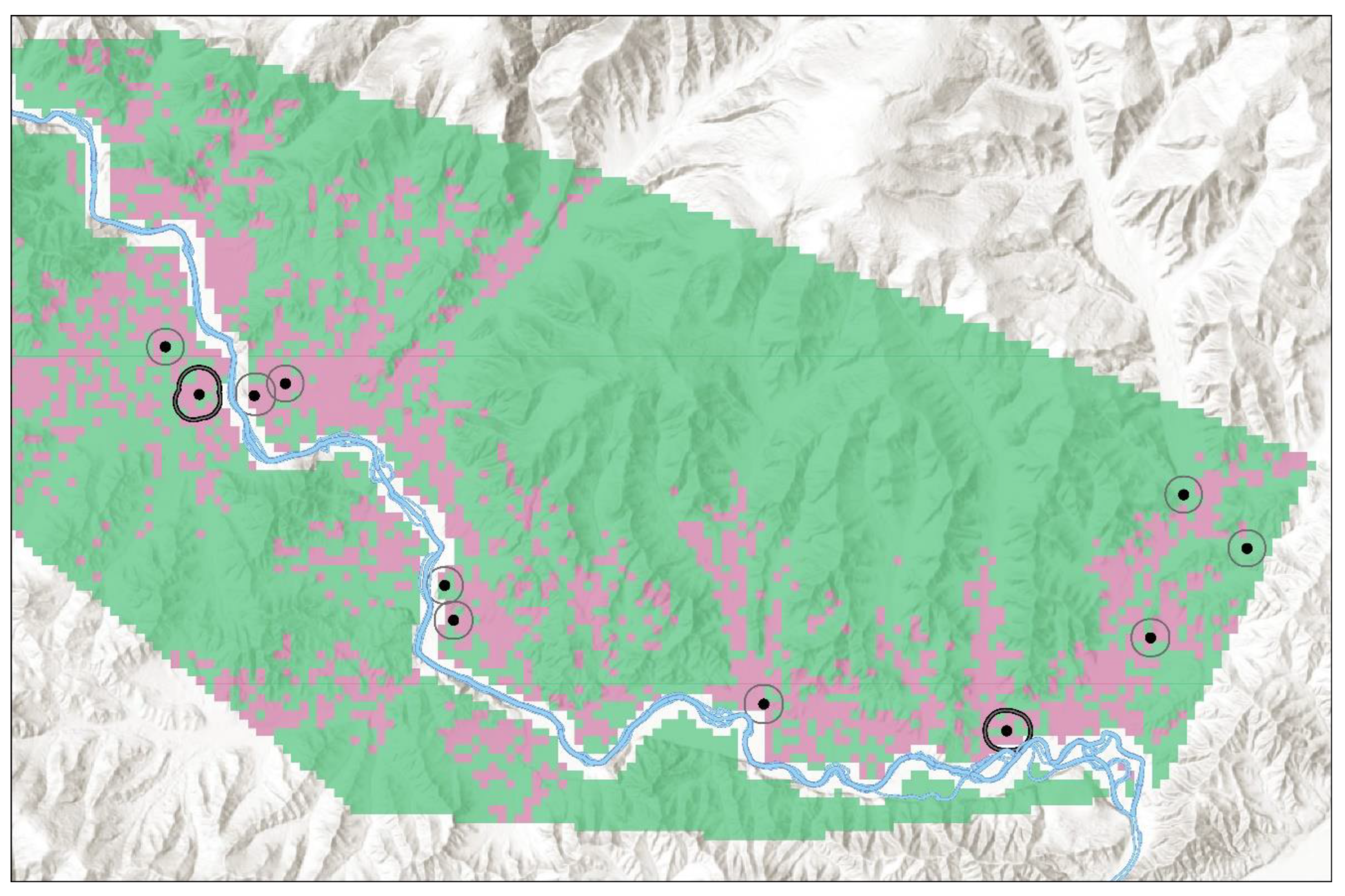
3. The Egiin Gol Valley Study Area

An opportunity to revisit and re-test earlier hypotheses based on one and the same survey dataset is a rarity made possible by impressive advances in analytical and statistical methods and in the quality of environmental data now available. In the 20 years since the original Egiin Gol project published its first results, archaeological laboratory methods have developed substantially, making entirely new insights available on sample collections. Our study area in north central Mongolia marks the transitional zone between the steppe and the mixed-species boreal forest of Siberia. On its way to the Selenge River, the final stretch of the Egiin Gol River flows through a forest-steppe landscape characterized by floodplains, terrace remnants, and flat-floored valleys formed by several perennial and seasonal tributaries. These low-lying areas are surrounded by north-south trending ridges reaching more than 1500 m in elevation. Grassland communities are dominated by moderately dry grass steppe and dry steppe with grass and sagebrush (Artemisia sp.), while mixed forest areas consist of pine (Pinus sp.), larch (Larix sp.), and birch (Betula sp.).
Average temperatures in January and July are −20.5 °C and +15.9 °C, respectively, and the means for annual precipitation range from 360 to 440 mm, with 70% of rainfall occurring in July and August. Studies of land surface age along the lower Egiin Gol River suggest that these landscapes have been relatively stable over the past two millennia. Even though local climate regimes have been variable, this has not imposed major changes in geomorphological regimes [72,73]. Lake core analysis at Khargal Lake (75 km to the northwest) indicates that the Xiongnu period local climate began to ameliorate around 250–200 BC and by the turn of the millennium became more like the contemporary climate experienced over the past few decades [74]. This reinforces observations by archaeobotanists that the same vegetation types and arboreal species seen today at Egiin Gol also appear as macro- and microbotanical remains in burials and habitation sites of the Xiongnu period [75,76].
Sheep (Ovis aries), goat (Capra hircus), cattle (Bos taurus), and horse (Equus caballus) pastoralism forms the basis of modern Egiin Gol subsistence, which includes the seasonal movement of herds, incorporation of agricultural and store-bought products, as well as seasonal hunting and gathering. Herding families in the area typically engage in seasonal migrations that entail a four-season movement circuit totaling between 8 and 15 km [60]. Observations from ethnographic research describe hunting of marmots, deer, elk, and wild boar, in addition to collection of wild berries, roots, and vegetables [77]. The greater forest–steppe region of Mongolia has a long history as the primary farming sector of the nation. Large dry-farmed collective fields were established in the area beginning in the 1960s and 1970s. Prior to that, local Buddhist monasteries organized a mixture of dry and irrigation-based farming beginning in the 18th and 19th centuries AD [61]. Archaeological fieldwork in the greater region has identified seasonal pit house settlements devoted to mixed pastoral and agricultural production dated to the period of the Mongolian Empire (13th c. AD) and medieval historical texts recount the integration of this region into the expanding Mongol state specifically to access its agricultural productive capacity [78]).
Multiple archaeological survey and excavation projects have been carried out over the past several decades at Egiin Gol, beginning in the 1990s and continuing off and on through 2015. Data and samples analyzed for this study come from seasonal settlements (i.e., nomadic encampments) recorded by systematic pedestrian survey in the Egiin Gol valley [61]. These habitation sites are shallow, low-density artifact scatters usually with no observable architectural investment but associated with subsurface hearth and pit features. Evidence for Xiongnu period and earlier pastoral lifeways and seasonal occupations, often with multiple return visits to the same or adjacent areas, comes from analysis of faunal assemblages, archaeobotanical remains, and valley wide settlement patterns [60,79,80]. The GIS analysis of landscape presented here is contingent on three botanical and isotopic projects, simultaneously in process of publication [41,81,82]. These analyses of Egiin Gol samples, which include formal archaeobotanical identifications and the application of stable (δ13C, δ15N) and radiogenic (87Sr/86Sr) isotope analyses, thus far comprise the most comprehensive research on local farming during the Xiongnu period. As supporting research for this paper, analytical results are briefly described below.

3.1. New Evidence for Cereal Crops at Egiin Gol

The application of stable carbon and nitrogen isotope analyses to questions of dietary reconstruction in the past is now a standard component in the analytical toolkit of archaeological research. The analysis of these stable isotopes from human and faunal remains in Mongolia has been utilized to demonstrate the degree of dietary diversity, as well as environmental factors, that characterize unique ecological settings in this area and across the steppes more broadly [39,83]. The rationale and methodology behind stable isotope analyses as applied to archaeological bone has been widely summarized (e.g., [84,85,86]). In brief, the stable isotope carbon-13 (δ13C) provides information about certain plant types in the diet, while nitrogen-15 (δ15N) gives an indication of the degree of protein consumption and trophic level placement within a particular food web [87]. The plant types refer to plants with variable photosynthetic pathways, for example C3 types such as wheat, barley, and temperate grasses, and C4 types such as maize and millets. A third type, CAM plants (referring to Crassulacean acid metabolism), switch from C3/C4 pathways but do not predominate in the eastern steppe ecosystem [88]. One limitation of the method is that it is not possible to identify consumption of C3 cultigens such as wheat or barley in a natural C3 ecosystem; thus, the predominant focus on the identification of possible millets (C4 input) in the diet of humans and/or non-human animals in this northern Mongolian area. The Egiin Gol valley is mainly characterized by C3 grasses and plant types, although across Mongolia there are some naturally occurring C4 types (e.g., Chenopodium sp.). It should be noted that these are more common in arid desert regions.
Current work on dietary reconstruction in the Egiin Gol valley, reported here, has demonstrated a clear shift in food consumption over time when a group of individuals from Late Bronze and Early Iron Age burial contexts (n = 19, BEIA) was compared with individuals from Xiongnu period burials (n = 37) [41]. This comparative and diachronic approach allows for a direct consideration of dietary change over time in a more reliable manner than existing multi-regional isotopic studies from Mongolia that rely on very few samples per area. Differences in local environment, such as those between temperate and more arid zones, known to impact isotopic results [83,89] are controlled for in this case by focusing on a single location. In addition, faunal remains associated with each respective time frame provide a further measure for comparative dietary indicators (BEIA n = 5, Xiongnu n = 13). The results demonstrate that in the earlier group (BEIA), both humans and local fauna (i.e., sheep (Ovis aries), goat (Capra hircus), and cattle (Bos taurus)) show primarily C3/mixed dietary intake. By comparison the individuals from the Xiongnu period show a greater degree of dietary diversity among the group, and a clear shift toward increased C4 inputs [41].
In the greater region, the uptake and presence of millets in archaeological contexts has been linked isotopically to the Bronze Age [36]. By contrast, evidence for Bronze Age adoption of millets at Egiin Gol and sites in neighboring Khovsgol province is not supported by the stable isotopic data, as individuals display signatures of more characteristic C3-based diets [83]. Our results affirm this dietary shift occurring markedly later in northern Mongolia coincident with the beginning of the Xiongnu period. It is important to reiterate that this does not rule out the possibility that plants of the C3 variety (i.e., wheats and barley) could have been a staple dietary source earlier than the evident uptake of the C4 contribution and future archaeobotanical studies will be required to address this issue. Although they represent a small percentage of the total flora in Mongolia, as noted above, edible naturally occurring C4 plants such as those in the Chenopodium genus and other members of the Amaranth family could have entered local diets during the Xiongnu period even if not consumed previously. However, given that archaeobotanical evidence shows that broomcorn millet also occurs initially at Egiin Gol during the Xiongnu transition (see below) a reasonable case can be made for millet as the new C4 dietary input.
Millet has only recently been identified in the flotation samples from two Egiin Gol Xiongnu habitation sites (EGS 110 and 486), both sites are characterized by diagnostic pottery and absolute dating [61] (Figure 2). These samples were collected from hearth and midden contexts for flotation between 1999 and 2002 (sampling and flotation-based recovery details provided in [61] and see [82]). Preliminary sorting and identification of the light fractions using low power binocular microscopy was carried out by H. Trigg at the University of Michigan [75]. Trigg identified carbonized wheat (Triticum sp.) and barley (Hordeum vulgare L.) as well as unidentified Cerealia which has been published and discussed widely in the Xiongnu archaeological literature [26,60]. These flotation samples were re-assessed using both a low-power binocular microscope and a Thermo Scientific Phenom XL G2 Desktop Scanning Electron Microscope (SEM) and the analysis results are briefly presented here and in full by Carolus and colleagues [82]. For the purposes of this overview, examination and discussion is limited to more complete cereal caryposes exhibiting sufficient morphological preservation. Beyond visual anatomical identification using microscopy, morphometric analysis was used to further characterize the assemblage.
Examinations of three separate flotation samples from EGS 486 (Figure 2), a river terrace settlement site, yielded caryposes of broomcorn millet (P. miliacium L.). EGS 110, another river terrace settlement site, also yielded broomcorn millet (Figure 2). Scanning electron micrographs of each item were examined morphometrically with ImageJ software (v. 1.53t) and compared to taxonomic guides and other published morphometric data. Complete specimens recovered from Egiin Gol morphometrically conform to accepted taxonomic identification guidelines [90,91,92,93]. The expanded re-analysis also verified Trigg’s identification of the presence of naked wheat (Triticum aestivum L.) and barley (Hordeum vulgare L.) and added significant detail in terms of the proportions of these C3 grains in the overall assemblage as well as inter- and intra-species diversity [82]. An important caveat concerning the initial appearance of these grains during the Xiongnu period is that flotation samples for the valley are very few and primarily targeted Xiongnu period habitations. Although a systematic macrobotanical analysis of flotation samples from an Early Iron Age hearth in the neighboring Tarvagatai valley failed to find any indication of grain [80], the possibility persists that greater sampling may reveal the presence of pre-Xiongnu cereals.
Confirmed identification of wheat and barley grains has had an additional benefit in generating a new study designed to assess the geographical origin of Xiongnu cereal crops recovered from Egiin Gol, based on comparative strontium (Sr) isotope analysis of archaeological and modern cereal grain samples [81]. The application of strontium isotope analyses to archaeological questions is built around comparing the ‘local’ signature of the geological substrates of a particular area to the strontium 87Sr/86Sr values of the analytical sample in question, whether that be bone collagen, tooth enamel, or plants [94,95]. Plants incorporate strontium from their growth media (e.g., soils) and water sources without fractionation; therefore, their 87Sr/86Sr values will reflect the geographic area in which they are grown. In cases where the analytical sample is dissimilar to the local Sr signature, a non-local origin is likely indicated. There are some obvious limitations in assessing the genuine “local-ness” of a strontium signature given that people, plants, or animals could have originated from areas with similar geological substrates, making their non-local origins virtually undetectable.
Additionally, issues of preservation and diagenesis can ‘mask’ non-local specimens, leading to measures to control for these effects in the analytical process [96]. Research on the effects of charring on the concentration of 87Sr/86Sr values of barley grains was carried out by Heier et al. [97], who also investigated optimal leaching methods to remove contaminating strontium. It was determined that leaching in 6M HCl for 24 h removed more than 95% of the exogenous Sr from carbonized grains [97]. Research by Benson [98] also determined that archaeological carbonized grains retained biogenic Sr more readily than uncarbonized specimens. The more recent study by Styring and colleagues [99], which revisited the approach to analyzing carbonized plant samples, found that the leaching process removed some but not all of the exogenous Sr from carbonized cereal grains, but highlighted the applicability of this process to successfully use carbonized grain as a geographical tracer while keeping limitations in mind.
In order to consider evidence for direct cultivation of cereal products in the Egiin Gol valley, carbonized archaeological cereal samples were compared with modern local wheat chaff and grain (n = 4) and a sample of local grass (n = 1) from the same general areas in which the EGS 110 and 486 sites were found (Figure 2). The archaeological grains analyzed consist of wheat (Triticum sp., n = 4) and barley (Hordeum vulgare, n = 4). The geological terrain from which the archaeological and modern sample Sr signatures are derived falls within the Selenge belt, a Permian–Triassic volcanic–plutonic formation that is bisected by the Buteel MCC (metamorphic core complex) [100,101,102,103]. Environmental or ‘local’ baseline Sr values for this area were established from both the modern plant samples and from previous work by Machicek and colleagues [104] based on archaeological human bone analyzed without control for diagenetic alteration in order to characterize the Sr value of local burial contexts.
The modern plant samples provide an average 87Sr/86Sr of 0.7085 (range = 0.7081–0.7087) and human bone an average of 0.7084 (range = 0.7071–0.7093). The 87Sr/86Sr results for the archaeological grains produced an average of 0.7086 (range = 0.7085–0.7087). More specifically, the results from the wheat samples averaged 0.7086 (range = 0.7085–0.7087), while barley also averaged 0.7086 (range = 0.7085–0.7087). Overall, the results for the archaeological samples are markedly similar to the local strontium signatures established for the modern plant samples and comparative archaeological bone, and thus are consistent with the likelihood that they are of local geographic origin [81]. In summary, these three studies taken together make a fairly robust case for Xiongnu period engagements with wheat, barley, and millet as a part of local diets and as crops being farmed locally at some scale. Questions remain as to the scale of this production and how the initiation of farming practices transformed local lifeways in terms of mobility, herding practices, and settlement.

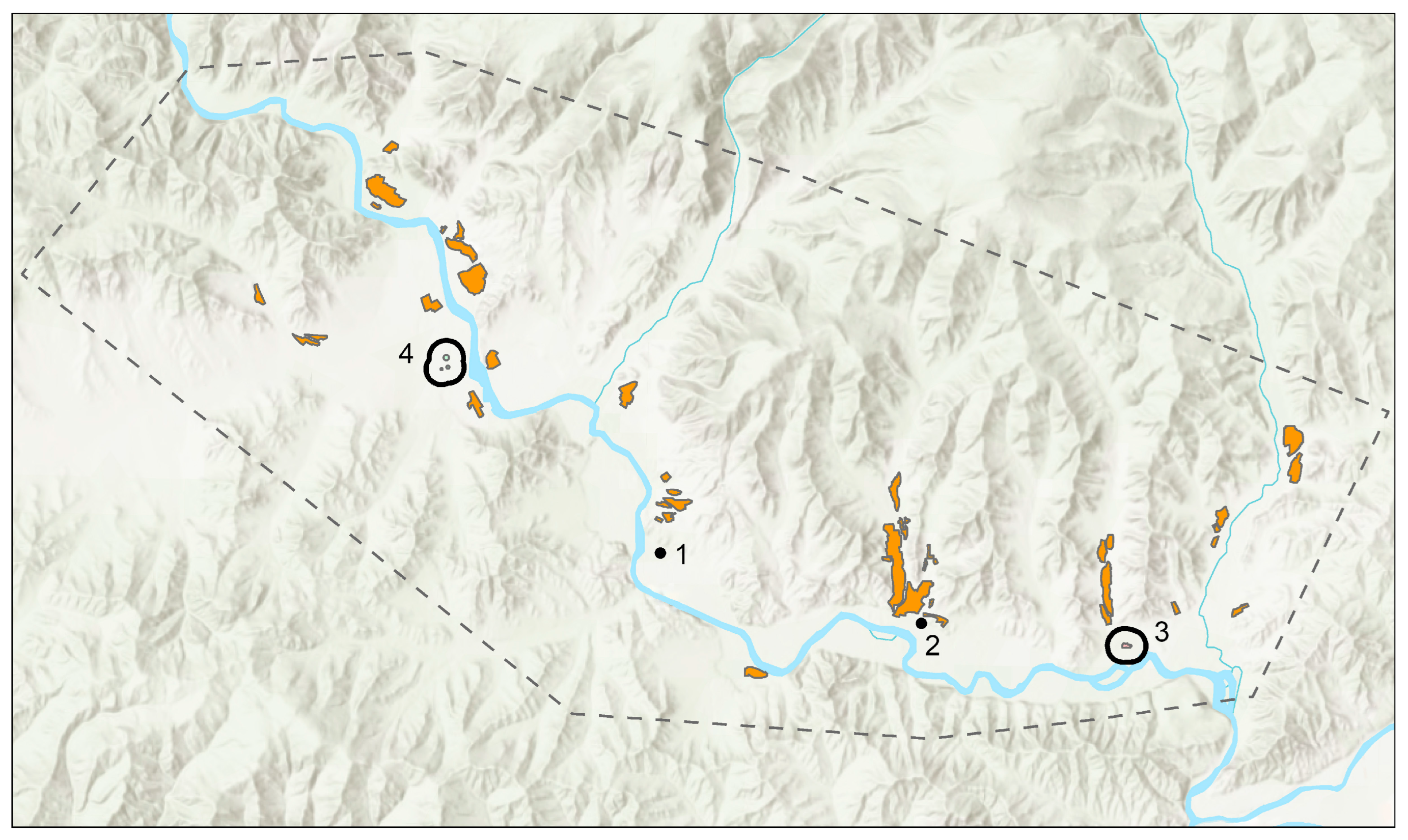
3.2. Egiin Gol Landscape Analysis: Materials, Data, and Methods
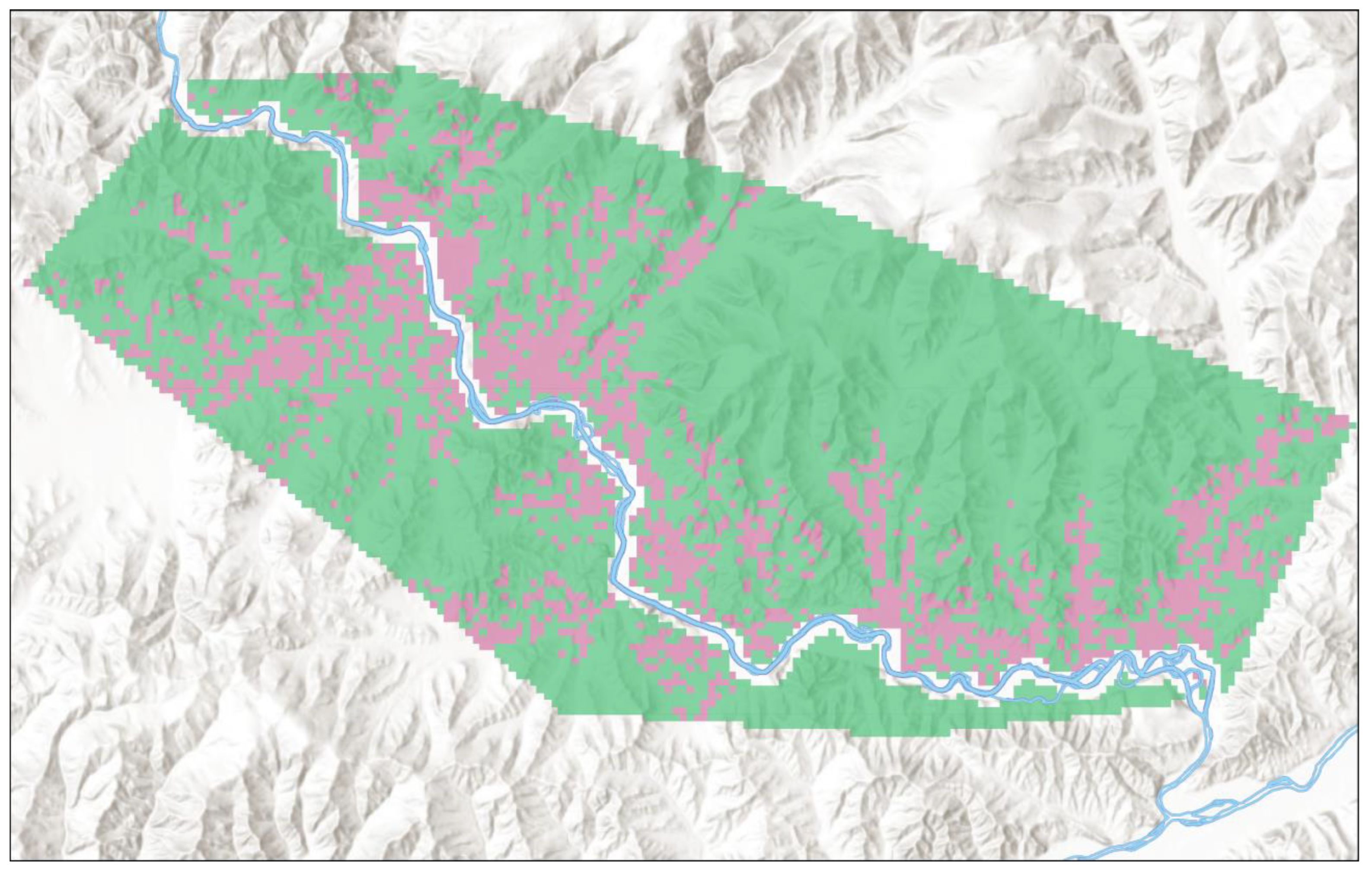
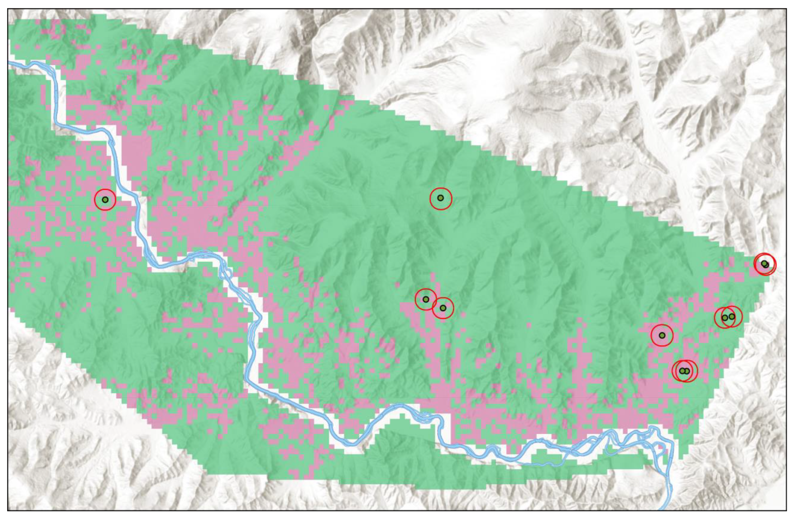
The Xiongnu period introduced major changes to the communities of Egiin Gol, including new technologies, material culture, mortuary practices, and undoubtedly a series of novel political relationships [26]. These changes should be understood as a larger package of interlinked transformations geared towards the production of a new kind of political community, one that during the third and second centuries BC gradually coalesced at a regional scale of integration. One of the most striking changes revealed by our pedestrian survey of the 1990s and early 2000s was the creation of an entirely new landscape in which settlement patterns shifted to significantly larger sites, mostly occupying the main Egiin Gol valley along river terraces [61,79]. Habitation sites in the upper portions of tributary valleys diminished suggesting a new orientation to local resources and a political landscape geared towards movement regimes in and out of the main valley. This transformed landscape alerted researchers to the fact that the Xiongnu political experiment was more than just an informal and modular joining of many small-scale polities centered in separate valleys and desert locales; rather, it was a genuine attempt to integrate steppe populations into an unprecedented large-scale organizational format. Some have gone as far as describing this new form of political consolidation as an experiment in nomadic statehood, while others describe it as an empire due to its impressive geographical expanse. At its height, the Xiongnu state held sway over territory ranging from Manchuria to the Altai mountains and from Siberia to northern China [49].
Past analyses of the changing Egiin Gol landscape started with what was observed and known about settlement transformations, and then posed a question about the influential factors involved. The hypothesized answers from 20 years ago concluded that even though little supporting evidence existed at the time, an initiation of crop production may have been a major determinant. In addition, the location of the two largest settlement areas, EGS 36 and EGS 297-99 (each 4 ha in size, Figure 2), established along the northwestern and southeastern mountain pass system exiting and entering the valley, likely had significance for extra-local interactions, probably of a political nature [8]. The GIS analysis supporting these proposals is based on a traditional ‘catchment’ model exploring the resource make up within a set perimeter around each Xiongnu period site to suggest the productive focus involved in the choice of site location [105]. Based on the recent isotopic and archaeobotanical results described above, we now have robust lines of evidence demonstrating grain consumption and farming in the valley. We are therefore able to turn our original question around to ask: to what degree does the inclusion of farming in local productive strategies explain the changes we observe in settlement patterns?
One way to accomplish this is to assess every part of the Egiin Gol valley for its pre-modern agricultural potential and then compare Xiongnu and pre-Xiongnu landscapes based on how each site assemblage references this derived dataset. Required is a spatial sample of farming plots, a series of variables pertinent to farming as data layers, and a method of classification that assesses these valley-wide data in terms of similarity to or difference from the known farming sample. The task of classification based on a training sample is well suited for the Random Forests statistical routine, a relatively new approach that overcomes the problem of overfitting a model as might occur with decision tree classification and logistic regression [106]. Random forest classifiers are widely used in machine learning algorithms and have a history of use in Mongolian archaeology. A random forests model was used to assist the identification of archaeological site locations, based on previously discovered sites, in a survey project preparing for the construction of a railway line immediately to the south of Egiin Gol [107].
A spatial sample of early agricultural field plots is available within the valley due to the past 250 years of agricultural production at Egiin Gol sponsored by a network of Buddhist monasteries established in the 18th and 19th centuries. Under the auspices of Buddhist authorities, local inhabitants tended herds and worked the fields using pre-modern technologies and experiential knowledge of the best locations for the support of cereal crops [61]. The cultivation of wheat and fodder crops using dry farming and runoff irrigation techniques has left remnant fields still visible on aerial photos and satellite images. Relict field plots were identified on aerial photos and then ground-truthed in the process of carrying out pedestrian survey in the valley. These were reviewed once again for this study using image processing software (ImageJ 1.53t and Adobe Photoshop 24.6.0) and high-resolution satellite images. The resulting field distribution comprises only those fields with high confidence identifications (Figure 2).
The nine data layers selected as variables pertinent to farming include geographic, hydrological, and pedological information, all sampled using a cell size of 250 m (Table S1). In the first category, the variables of slope, aspect, and solar radiation were modeled using a 30 m ALOS DEM and the requisite analytical tools in ESRI ArcGIS Pro 3.0. Distance from runoff used the same DEM and software platform to construct a valley-wide hydrological model, in which a minimum threshold of 50 cell flow renders an adequate runoff stream network. Every cell was then assigned a distance to the nearest segment of this network, and the Egiin Gol river was excluded, since it made no contribution to field irrigation. Soil information grids were collected from two global soil data repositories: Open Land Map (https://opengeohub.org/about-openlandmap/) (accessed on 1 May 2023) and ISRIC (https://www.isric.org/explore/soilgrids) (accessed on 1 May 2023), at 250 m horizontal resolution and depths from 0 to 10 cm. The five attributes for Egiin Gol soils include organic carbon (0 cm), nitrogen (0–5 cm), moisture (10 cm), soil pH (10 cm), and soil type based on the USDA classification system. These soil data are the result of both on-the-ground geological observations and machine learning designed to interpolate information for points where recorded information is sparse [108,109]. Assembled in a GIS, these nine layers of data can be vertically queried for any 250 m point to provide a multivariate set of farming pertinent observations statistically comparable to the relict field targets points (see Table S1 for additional information).
The full dataset for the Egiin Gol Survey project (1997–2000, 2002) is available, including site descriptions, testing and excavations, artifacts recovered, and dating methods [61]. Although analysis and especially radiocarbon dating of these contexts for all periods is ongoing, the archaeological sites used here to represent the valley’s Bronze and Early Iron Age (BEIA, c. 1200–300 BC) and Xiongnu period (c. 250 BC–150 AD) are those reviewed and vetted by the co-directors of the original survey [68,69,70]. BEIA habitations (n = 11) tend to be smaller in average size (0.19 ha) and are distributed mostly along tributary valleys with a few sites in the main Egiin Gol valley. These sites comprise surface and shallow subsurface scatters of pottery and often lithic tools. Six of the 11 sites have been tested with excavation and, of these, two have been radiocarbon dated to the mid first millennium BC, while the others were dated based on diagnostic pottery rims and decorations (Table S2).
Eleven Xiongnu period habitations are included here, of which one site (EGS 297-99) is a compilation site. Of these, four have had some degree of excavation and all four are directly dated by radiocarbon analyses. Additionally, all sites can be assigned to the Xiongnu period based on diagnostic artifacts including pottery, coins, and bronze mirrors (Table S2). Xiongnu encampments tend to be comparatively large on average (1.34 ha) and inhabitants favored locations in the main Egiin Gol valley over those in tributary valleys, although both areas are in use during this time. The two largest sites of this period mentioned above, EGS 36 and 297-99, are of special interest due to their four-hectare spatial extents. EGS 36 is a consolidated pottery, artifact, and metallurgical slag scatter that we collected systematically using 20 × 20 m collection units across its 4.1 ha area. EGS 297-99 is actually three sites so closely spaced (100–200 m apart) that we group them together as a single occupation area and sum their respective site areas to arrive at a 4.2 ha (Figure 2).
Given that each site is an artifact scatter representing a zone of ancient activity, the exact location of living and production areas is seldom distinguishable, especially given that most sites from both time periods are currently within modern agricultural fields. To determine an immediate area around each site in which farming might have taken place, we turn to the geographical literature to find cross-cultural research on travel distances from living areas to field plots. Chisholm [110] finds that distances up to 1 km are usual and Baker’s [111] research suggests a range of 0.5–1.5 km as more representative of traditional farming landscapes. Since several Xiongnu habitations are situated on river terraces about 500 m away from the Egiin Gol river, we selected a perimeter of that size to surround the spatial extent of sites from both periods.

4. Results

We delimited the lower Egiin Gol study area using all archaeological sites recovered by the survey to represent the full land use extent and then used a minimal bounding polygon to enclose the valley region outlined by the sites. The total 250 m cell count for the study area is 10,140 of which 265 cells are overlapped by relict fields; 121 cells comprise BEIA habitation with 500 m site buffers, and for the Xiongnu period that count is 165 cells. Each cell comprises the nine variables listed above pertaining to that respective area. We apply a random forests analysis to the training sample of relict fields in order to build a model fitted to that initial sample, and then evaluate the entire dataset via that model. Random forests is a powerful classifier because it relies on multiple rather than a single decision tree to find the composition of variables that best segregate relict fields from non-relict fields. The random forests algorithm aggregates many such decision trees derived from randomly selected variable subgroups and then chooses the best divisive branches among them based on the most common or majority solution [106].
The first step in the process is to generate multiple and diverse classifier solutions (i.e., ‘trees’) derived from randomly-sampled-with-replacement (i.e., bootstrap) compositions of the available training dataset. Each branch or node in these decision trees then receives a random subsample from their respective bootstrapped dataset to work with in order to select the best feature for dividing upon. In the growing of each decision tree, a reserve subsample of 1/3 is left out as an Out of Bag (OOB) unseen test sample to assess the resulting decision trees. Importantly, the OOB sample is not uniform across all trees, but varies per tree, and so when used to assess the outcomes, it does not constitute a validation test of the entire model—a step that comes later after the model is constructed. All decision trees are evaluated together as an ensemble (i.e., a forest) by assessing across the trees to determine for each branch the most common or the majority feature selected for splitting. This process is often referred to as a majority vote, and the final model is the compilation of these majority branching structures [106]. A validation of the whole model can be performed if a percentage of the original training data is excluded, thereby providing two assessments of model fit from both the internal Out of Bag error and the whole model validation error. Because the random forest classifier incorporates random diversity at every step of its building process, the resulting model minimizes issues with overfitting, reduces intercorrelations between variables, and can account for subtle complexities in the data that a single decision tree or other multivariate classifiers cannot [107,112].
To produce robust results for the Egiin Gol valley, we generated multiple models for the relict fields training data to improve model fit by varying the number of ‘trees’, removing less meaningful variables, and seeking to minimize both Out of Bag (OOB) error and whole-model validation error using 20% of the training data held in reserve. ESRI’s ArcGIS Pro Geoprocessing platform provides a random forest routine that enables the direct input and output of spatial grid data and with this toolset we explored training models using defaults for minimum leaf size, maximum tree depth, and 100% of ‘bagged’ data available for each tree. We arrived at a 275-tree solution that provided minimal if not ideal levels of error for both OOB and validation tests. OOB error is the percent of miscalculations in identifying fields or non-fields by decision trees that were not trained on a specific portion of data held in reserve and serves to give an assessment of decision tree adequacy. The trained model had an OOB error of 32% for classifying relict fields and a 9.6% error for non-fields. Throughout the iterative model training process OOB errors for field areas assignment were consistently relatively high and those for non-field assignments were consistently low. This points to complexities in the relict field training data, which include variability that is difficult to resolve.
Validation of the whole model against the 20% of data held out also reveals this complex variability, but the model still retains a high level of classificatory potential. Based on a confusion matrix, the model’s identification of non-fields was correct 91% of the time (i.e., model sensitivity) and for the identification of relict fields, correct 70% of the time. Considering both true positive and true negative classifications for the model overall (i.e., accuracy), the performance is 84% correct. F1 scores for the classification of non-fields and fields are 0.89 and 0.72, respectively. Random forests also provides a hierarchy of variable importance based on a rank order of Gini coefficients indicating how significant a variable is in the model. Importance is a measure of how often a particular variable is responsible for a branching in the ensemble of decision trees divided by the total number of trees. The order of the nine variables we worked with in training the model remained quite stable throughout the many iterations we tested. Soil pH, moisture levels, and organic carbon are consistently the top three most important variables. These are followed by aspect, solar radiation, percent slope, runoff, soil nitrogen, and least of all, soil class. All variables comprised 10% or more of the total sum of Gini coefficients except for soil class, but despite its low importance, the removal of soil class resulted in poorer outcomes for both OOB and model validation errors. Full information on our final model is provided in Supplementary Table S3.
The random forest classification of the Egiin Gol study area resulted in 2100 cells out of 10,140, or 21% of the valley, being classified as suitable for farming based on the agricultural proxy of the relict fields (Figure 3). The overall spatial distribution of the field-classed cells is what would be expected: most cells are in areas where relict fields exist but extend outwards along parts of the Egiin Gol river terraces and into the tributary valleys, especially near valley entrances. A few swathes of field cells extend farther up into the broadest side valleys where slopes are low, streams tend to be perennial, and colluvial and alluvial soils are rich in nutrients. The 11 BEIA habitation sites and their associated 500 m perimeters occupy 121 cells or 7.56 km2 of this landscape. Of those, 71 cells are classed as non-field and 50 cells are rated as suitable for field plots. A total of 41% of accessible lands during the BEIA period would have been well suited for local farming (Figure 4).
In comparison, the Xiongnu period habitations plus their respective perimeters occupy 165 cells in the valley or 9.75 km2 of accessible land. Of this area, the random forest model classified 73 cells as not well suited for fields and 92 cells, or 56% of the accessible land, as good for farming (Figure 5). A two-sample z-test for difference between proportions given these two results indicates that the proportions of accessible land for farming is significantly different between the pre-Xiongnu and Xiongnu periods, and not just due to the vagaries of sampling (z = −2.412, p = 0.016). The two Xiongnu period settlements that most prominently represent a shift in settlement pattern due to their large expanse, EGS 36 and 297-99, are of special interest for this analysis. As explained above, one of the main hypotheses explaining these large habitations areas is that they may have been newly established locations for farming, as well as centers of some political prominence in the valley. We would expect that access to suitable farmland for these two sites should be notable. Overall, Xiongnu sites and their perimeters in the Egiin Gol valley have 56% of accessible land classified as suitable for farming while EGS 36 has 67% and EGS 297-99 has 65% of nearby land classed as good for agricultural fields (Figure 5). Given these results, the Xiongnu period landscape organization is consistent with a novel focus on access to farmland, presumably to support the agricultural production and grain consumption documented by our isotopic and archaeobotanical projects. This evidence argues for a radical transformation of lifeways in the Egiin Gol valley with the onset of the Xiongnu period.

5. Discussion

EGS 36 and 297-99 are special habitation areas that to this day remain somewhat of a mystery. Revealing a plausible connection to the start-up of local farming practices is a major step forward, but there are still questions to be answered about these sites and their relation to other Xiongnu settlements in the valley and beyond. Based on the 100% surface collection at EGS 36, we know that the pottery distribution is non-random and occurs in clusters suggestive of living areas. These might represent yurt or ‘ger’ placements within a large settlement, and inhabitants may have returned seasonally, erecting the mobile domiciles more or less in the same places year after year [26]. On the other hand, this patterning of artifacts might also represent wooden cabins as used today by herders during the warm season [61], or perhaps even a pit house settlement that could have sheltered occupants into the colder periods of the year.
Collections at this site also yielded a number of artifacts suggestive of higher-status denizens, including coins from the Han Dynasty, lamellar armor pieces, bronze horse harnessing gear, and iron working slag—all recovered within the same sector of the settlement. There is also a slightly higher incidence of imported pottery found at both EGS 36 and 297-99 based on neutron activation analysis (INAA) [68]. From survey projects in neighboring valleys, we now know that the Xiongnu landscape of Egiin Gol is unique and the large cemetery sites and substantial settlements of our study area do not occur in areas 20–30 km to the north [113], indicating a special centrality in the greater region for the Egiin Gol valley. Unfortunately, excavation at EGS 36 reveals that most of what was once subsurface cultural deposit now sits in the plow zone of a modern agricultural field, delimiting what we can say about this settlement and about its sister site of EGS 297-99 as well. Given the available information, however, our hypothesis that these newly established and much larger Xiongnu settlements were situated with both agricultural production and internal and external political concerns in mind is a probable explanation.
Still another significant question to be answered is why such radical change in lifeways occurred at this time and why this change centered upon the uptake of cereal agriculture. A great deal more research needs to be done on this question in other parts of the Mongolian plateau, but the idea that cereal grains, and primarily millet, were dietary markers of elite status finds some indirect support from isotopic studies from the Gobi regions of central Mongolia [39]. Northern forest–steppe products are typically recovered from local elite Xiongnu burial sites in the Gobi Desert, including pine and larch timbers, birchbark items, composite bow remnants originally made with northern woods and fish-based glues, and the occasional remains of forest dwelling animals. These products were not only transported southwards within the Xiongnu polity but were also likely symbolically laden with political significance since the northern regions of Mongolia comprised the major centers of power during the Xiongnu period. The importance of marking local elite status using products circulated between different regions of the early Xiongnu state suggests a method of political integration intended to bind together geographically dispersed communities [26]. Ancient DNA research advances a similar hypothesis for the interregional circulation of elite marriage partners as yet another practice facilitating political integration [114,115].
Based on inclusions in burial contexts, it is already clear that millet had a specific symbolic importance within the Xiongnu state [53]. As a quintessential product of the northern forest zone, perhaps the circulation of millet southwards to Gobi communities for local elite consumption also had political significance. This hypothesis is not entirely original. One version of this proposal was suggested by Davydova [23,58] based on her discoveries at the Ivolga settlement in Transbaikal (Figure 1) of evidence for agricultural production as well as some of the same cultigens found at Egiin Gol. Davydova maintains that Ivolga was a resource center dedicated to specialized craft production and farming for circulation throughout the state as one part of the Xiongnu political economy [23]. Although she emphasizes cereals as a staple food source rather than as a marker for elite foodways, the basic idea of the distribution of valued foods as a method for regional scale political integration is one we agree with. Consistent with this hypothesis, preliminary isotopic evidence for millet consumption among local elites in the Gobi Desert region has been presented [27,39]. However, due to the greater presence of C4 vegetation in the arid south of Mongolia, these assertions require additional testing. Further investigation will also help to distinguish between staple and symbolic uses of cereal grains among the Xiongnu.
Ivolga is just one of several Xiongnu settlements in the north with evidence for cereals and local farming and the Egiin Gol valley might be included among these sites as one of the more southerly regions mobilized for Xiongnu agricultural production as part of an early expanding state. While Ivolga is a somewhat unique fortified settlement with internal pit houses and a large Xiongnu cemetery nearby, other sites such as Dureny and Boroogiin Suurin are smaller pit house settlements (Figure 1) with evidence for agricultural production and storage [59,116]. Notably, the inhabitants of these sites retained high investments in pastoralism according to faunal analyses showing that herd species were central to settlement subsistence. However, in each case, scholars choose to emphasize the importance of finding what seem to be permanent settlements of farming inhabitants within a mobile herding society—as if these adaptations were entirely distinct. Evidence for sophisticated heating systems inside households at Ivolga, Dureny, and Boroogiin Suurin indicate cold season and likely winter occupations, but herd animals without shelter in these open valley landscapes would have had difficulty surviving extremely cold and windy winters. It would have made good sense for herds and herders associated with these settlements to have moved seasonally within orbit of these sites (cf. [56,59]). These detailed issues of animal management have not been fully considered as of yet, although Davydova [23] does speculate about areas to pen younger animals within the Ivolga settlement. No other structures have been documented that might have protected animals during the cold season. What is greatly needed, therefore, is a regional perspective to assess what Frachetti [9] has called the ‘pastoral landscape’ in which these potentially year-round habitations were embedded, and their animals managed and cared for (see also [117,118].
In contrast, the regional perspective available from Egiin Gol, in conjunction with faunal, archaeobotanical, isotopic, and lake sediment analyses, demonstrates the integration of mobile herding with the new productive emphasis on agriculture. Cores from nearby Khargal Lake reveal the coeval appearance of pollens associated with agriculture but also a notable uptick in Sporormiella sp., a fungal spore that is found on the dung of domestic livestock [74]. From a settlement perspective, survey results show fewer upper tributary valley habitations in areas where protection from winter conditions would have been optimal; however, these winter sites are indeed present. They increase in size as do other Xiongnu period sites, but they also conform to the size differences seen between warm weather main valley sites (i.e., larger) and cold weather side valley sites (i.e., smaller). As such, they speak to the continuation of a main valley (summer) to tributary valley (winter) seasonal mobility pattern. The seasonality of these movements has been demonstrated by the young age of animals at two sites in the main valley, indicating a warm season period of encampment as well as by the make-up of botanical assemblages consistent with the summer season [60,61]. When comparing herd animal stable isotopes between the BEIA and Xiongnu periods, changes in herd management are apparent. Increased carbon and nitrogen signatures are suggestive of the use of different foddering or pasturing practices during the Xiongnu period, and the possibility of herds having been grazed in manured fields [41]).
These adjustments to pastoral practices, along with the evidence for continued seasonal mobility among some portion of the Egiin Gol Xiongnu population, indicate a capacity to accommodate local methods of mobile herding to include a large-scale investment in farming. Rather than describing these nuanced transformations simply as ‘mobile herders’ becoming ‘settled farmers’, the concept of a flexible multiresource pastoralism better captures the processes we observe in the Egiin Gol valley. Moreover, these shifts in local economy also speak to the accommodation of a developing political environment. If indeed an elite cuisine incorporating millet was one way for local leadership to distinguish themselves, and millet for re-circulation had to be obtained from farming regions like Egiin Gol, then surely this one instance of statecraft placed heavy demands on communities where farming was possible. The exact process of negotiation leading to farming in the Egiin Gol valley from a political standpoint is still obscure, but we can at least assert that a tradition of multiresource pastoralism enfranchising flexibility and modulation was likely harnessed in the service of the rising state.

6. Conclusions

Clearly, 20 years today makes a difference for 2000 years ago, in terms of advances in archaeological analysis and data and what archaeologists can say about the past. The Egiin Gol Survey of the 1990s and early 2000s captured lines of evidence suggestive of a major transformation in the valley during the florescence of the Xiongnu polity. Our analyses at the time could do no more than plausibly hypothesize an uptake of farming locally as partly behind these changes. Twenty years on, the sophistication and availability of analytical procedures for isotopic, archaeobotanical, and GIS research has tested these earlier ideas and contributed additional lines of evidence in support of the farming hypothesis. This is not of minor importance, since the Egiin Gol results represent a watershed moment in Xiongnu archaeological theory. This pertains both to our understanding of early mobile herding but also to conceptualizing links between the steppe pastoral tradition and the making of a nomadic politics that could support an integrated regional polity [119].
These Xiongnu period developments in valley farming were not the last word in agricultural and multiresource adaptations in the greater region. Xiongnu material culture and organizational patterns disappear as active practices from the Egiin Gol valley sometime during the second century AD and along with them, the large habitations sites and centralized cemeteries in the valley also go out of use. These former Xiongnu activity areas were not directly re-occupied at a later time, and farming seems to lessen as a major activity. The demise of large-scale farming at Egiin Gol with the diminishment of the Xiongnu polity is, in and of itself, a telling fact. However, although daily practices might change, the residue of experience left behind from farming certainly endowed local culture with knowledge, techniques, and understandings that could be recalled from social memory and innovated upon at smaller or even larger scales. We have no evidence of cultivation at Egiin Gol for several centuries following the Xiongnu period, but millet appears in neighboring valleys during the fifth–sixth century AD [120], and historical reports refer to farming plots at the nearby walled center of Baibalyk during the 9th century AD [8]. With the rise of the Mongol empire, once again the region becomes an agricultural hub, although with a very different form of organization from that of the Xiongnu era [78]. This period of medieval farming was subsequently followed by the Buddhist and local communities that left behind the relict fields we document here. Several monasteries in the greater region supported both large-scale farming and mobile herding at Egiin Gol, as well as in neighboring valleys [61]. The same conditions pertain today at Egiin Gol under a relatively new free market system for Mongolian agriculture.
How people of a specific geographical region have constructed and maintained food cultures over time with reference to local ecology, retained knowledge and skillsets, and socio-political contexts is both a fascinating research question and one well suited to the strengths of archaeology [16]. The history of food culture at Egiin Gol as described here is complex and requires a nuanced theoretical model to make sense of environmental, economic, socio-cultural, and political factors. Simple typological labels fail to accomplish this task and even though we have used the term ‘agropastoral’ in previous work, labeling the Xiongnu changes at Egiin Gol as ‘mobile herders transforming into farmers or agropastoralists’ says little about how or why such novel transformations unfold diachronically.
Moving beyond descriptive research on early food cultures and framing questions in terms of process are the great strengths of Salzman’s concept of multiresource pastoralism (contra [17]). Salzman’s concept clearly does not diminish the possibility of a detailed account of how agriculture was practiced in the past, nor does it apply only to very small-scale forms of farming. Rather, it begs the important question of what knowledge and practice-based synchronicities existed between mobile herding and farming that could have facilitated a practical and creative joining of the two. At Egiin Gol, we argue that cereal production was integrated into pastoral nomadic lifeways as an exploitation of the ingrained flexibility those lifeways were premised upon. In other words, the Mongolian experience was one in which grain consumption and production would have been grafted onto a core animal-focused system to produce a malleable hybrid that very likely took different forms in different areas along the forest-steppe belt. Herding and seasonal mobility were as important a part of this hybrid as permanent settlements for farming, and this innovative mixture is what made Xiongnu agriculture resilient and of great significance as a case study.

Supplementary Materials

The following supporting information can be downloaded at: https://www.mdpi.com/article/10.3390/land12091715/s1, Table S1: Additional information on data layers used as input to random forest analysis; Table S2: Archaeological sites used in analysis, Table S3: Specifications and diagnostics for the random forests model.

Author Contributions

W.H.: Conceptualization, Data Analysis, Investigation, Methodology, Funding Acquisition, Writing—Original Draft and Preparation, Writing—Review and Editing. C.A.: Resources, Data Analysis, Data Curation, Methodology. J.W.: Resources, Data curation, Data Analysis, Writing—Review and Editing. C.C.: Conceptualization, Data Analysis, Investigation, Methodology, Writing—Original Draft and Preparation, Writing—Review and Editing. M.H.: Conceptualization, Data Analysis, Investigation, Methodology, Writing—Original Draft and Preparation, Writing—Review and Editing. All authors have read and agreed to the published version of the manuscript.

Funding

This research received no external funding.

Data Availability Statement

Data for the Egiin Gol Survey are available in [61].

Acknowledgments

The Egiin Gol Survey Project received generous support from the Wenner-Gren Foundation. Our work would not have been possible without the assistance of D. Tseveendorj, former director of the Institute of Archaeology, Mongolian Academy of Sciences. We would also like to thank the University of Michigan Museum of Anthropology and the Smithsonian Institution, National Museum of Natural History, Department of Anthropology. Particular thanks are due to the people of Egiin Gol, Mongolia, who helped us immensely in understanding their valley. Our work has also benefited greatly from comments and assistance from Heather Trigg, Zagd Batsaikhan, Diimaajav Erdenebaatar, Jargalan Burentogtokh, and Victoria Wilson.

Conflicts of Interest

The authors declare no conflict of interest.

References

  1. Ingold, T. Khazanov on nomads. Curr. Anthropol. 1985, 26, 384–387. [Google Scholar] [CrossRef]
  2. Makarewicz, C. A pastoralist manifesto: Breaking stereotypes and re-conceptualizing pastoralism in the Near Eastern Neolithic. Levant 2013, 45, 159–174. [Google Scholar] [CrossRef]
  3. Honeychurch, W. Alternative complexities: The archaeology of pastoral nomadic states. J. Archaeol. Res. 2014, 22, 277–326. [Google Scholar]
  4. Alden, J.R. Review of D.T. Potts. Nomadism in Iran: From antiquity to the modern era. Antiquity 2015, 89, 996–997. [Google Scholar] [CrossRef]
  5. Ingold, T. Time, social relations and the exploitation of animals: Anthropological reflections on prehistory. In Animals and Archaeology; Clutton-Brock, J., Grigson, C., Eds.; Early Herders and their Flocks; Archaeopress: Oxford, UK, 1984; Volume 3, pp. 3–12. [Google Scholar]
  6. Dyson-Hudson, N. The study of nomads. In Perspectives on Nomadism; Irons, W., Dyson-Hudson, N., Eds.; E. J. Brill: Leiden, The Netherlands, 1972; pp. 2–29. [Google Scholar]
  7. Dyson-Hudson, R.; Dyson-Hudson, N. Nomadic Pastoralism. Annu. Rev. Anthropol. 1980, 9, 15–61. [Google Scholar] [CrossRef]
  8. Honeychurch, W.; Amartuvshin, C. Hinterlands, urban centers, and mobile settings: The “new” Old World archaeology from the Eurasian steppe. Asian Perspect. 2007, 46, 36–64. [Google Scholar] [CrossRef]
  9. Frachetti, M. Pastoralist Landscapes and Social Interaction in Bronze Age Eurasia; University of California Press: Berkeley, CA, USA, 2008. [Google Scholar]
  10. Honeychurch, W.; Makarewicz, C. The archaeology of pastoral nomadism. Annu. Rev. Anthropol. 2016, 45, 341–359. [Google Scholar]
  11. Brite, E.B.; Kidd, F.; Betts, A.; Cleary, M.N. Millet cultivation in Central Asia: A response to Miller et al. Holocene 2017, 27, 1415–1422. [Google Scholar] [CrossRef]
  12. Wright, J. Households without Houses: Mobility and Moorings on the Eurasian Steppe. J. Anthr. Res. 2016, 72, 133–157. [Google Scholar] [CrossRef]
  13. Salzman, P. Multi-resource nomadism in Iranian Baluchistan. In Perspectives on Nomadism; Irons, W., Dyson-Hudson, N., Eds.; E. J. Brill: Leiden, Germany, 1972; pp. 60–68. [Google Scholar]
  14. Salzman, P. Pastoralists: Equality, Hierarchy, and the State; Westview Press: Boulder, CO, USA, 2004. [Google Scholar]
  15. Rouse, L.M.; Doumani Dupuy, P.; Brite, E.B. The agro-pastoralism debate in Central Eurasia: Arguments in favor of a nuanced perspective on socio-economy in archaeological context. J. Anthropol. Archaeol. 2022, 67, 101438. [Google Scholar]
  16. Chang, C. Rethinking Prehistoric Central Asia: Shepherds, Farmers, and Nomads; Routledge: London, UK, 2018. [Google Scholar]
  17. Spengler, R.; Miller, A.V.; Schmaus, T.; Matuzeviciute, G.M.; Miller, B.K.; Wilkin, S.; Taylor, W.T.T.; Li, Y.; Roberts, P.; Boivin, N. An imagined past? Nomadic narratives in Central Asian archaeology. Curr. Anthropol. 2021, 62, 251–286. [Google Scholar] [CrossRef]
  18. Jones, M.; Hunt, H.; Lightfoot, E.; Lister, D.; Liu, X.; Motuzaite Matuzeviciute, G. Food globalization in prehistory. World Archaeol. 2011, 43, 665–675. [Google Scholar] [CrossRef]
  19. Liu, X.; Jones, P.J.; Matuzeviciute, G.M.; Hunt, H.V.; Lister, D.L.; An, T.; Przelomska, N.; Kneale, C.J.; Zhao, Z.; Jones, M.K. From ecological opportunism to multi-cropping: Mapping food globalisation in prehistory. Quat. Sci. Rev. 2019, 206, 21–28. [Google Scholar]
  20. Ritchey, M.M.; Sun, Y.; Matuzeviciute, G.M.; Shoda, S.; Pokharia, A.K.; Spate, M.; Tang, L.; Song, J.; Li, H.; Dong, G.; et al. The wind that shakes the barley: The role of East Asian cuisines on barley grain size. World Archaeol. 2021, 53, 287–304. [Google Scholar] [CrossRef]
  21. Rosen, A.; Chang, C.; Grigoriev, F.P. Palaeoenvironments and economy of Iron Age Saka-Wusun agro-pastoralists in southeastern Kazakhstan. Antiquity 2000, 74, 611–623. [Google Scholar] [CrossRef]
  22. Chang, C.; Tourtellotte, P. The Role of Agro-Pastoralism in the Evolution of Steppe Culture in the Semirecheye Area of Southern Kazakhstan During the Saka/Wusun Period (600 BCE-400 CE). In The Bronze Age and Early Iron Age Peoples of Eastern Central Asia; Mair, V.H., Ed.; Institute for the Study of Man, Inc.: Washington, DC, USA, 1998; Volume 1, pp. 264–279. [Google Scholar]
  23. Davydova, A.V. The Ivolga gorodishche: A monument of the Hiung-Nu culture in the Trans-Baikal region. Acta Archaeol. Acad. Sci. Hung. 1968, 20, 209–245. [Google Scholar]
  24. Hastorf, C. The Social Archaeology of Food: Thinking about Eating from Prehistory to the Present; Cambridge University Press: Cambridge, UK, 2016. [Google Scholar]
  25. Frachetti, M.D. Differentiated landscapes and non-uniform complexity among Bronze Age societies of the Eurasian steppe. In Social Complexities in Prehistoric Eurasia: Monuments, Metals, and Mobility; Hanks, B.B.K., Linduff, K., Eds.; Cambridge University Press: Cambridge, UK, 2009; pp. 19–46. [Google Scholar]
  26. Honeychurch, W. Inner Asia and the Spatial Politics of Empire: Archaeology, Mobility, and Culture Contact; Springer: New York, NY, USA, 2015. [Google Scholar]
  27. Miller, A.R.V.; Makarewicz, C.A. Intensification in pastoralist cereal use coincides with the expansion of trans-regional networks in the Eurasian Steppe. Sci. Rep. 2019, 9, 8363. [Google Scholar]
  28. Frachetti, M.D. Multiregional emergence of mobile pastoralism and nonuniform institutional complexity across Eurasia. Curr. Anthropol. 2012, 53, 2–38. [Google Scholar]
  29. Zhou, X.; Yu, J.; Spengler, R.N.; Shen, H.; Zhao, K.; Ge, J.; Bao, Y.; Liu, J.; Yang, Q.; Chen, G.; et al. 5200-year-old cereal grains from the eastern Altai Mountains redate the trans-Eurasian crop exchange. Nat. Plants 2020, 6, 78–87. [Google Scholar] [CrossRef]
  30. Hermes, T.R.; Frachetti, M.D.; Doumani Dupuy, P.N.; Mar’yashev, A.; Nebel, A.; Makarewicz, C.A. Early integration of pastoralism and millet cultivation in Bronze Age Eurasia. Proc. R. Soc. B 2019, 286, 20191273. [Google Scholar]
  31. Spengler, R.; Frachetti, M.; Doumani, P.; Rouse, L.; Cerasetti, B.; Bullion, E.; Mar’yashev, A. Early agriculture and crop transmission among Bronze Age mobile pastoralists of Central Eurasia. Proc. R. Soc. B 2014, 281, 20133382. [Google Scholar] [CrossRef]
  32. Doumani, P.N.; Frachetti, M.D.; Beardmore, R.; Schmaus, T.; Spengler, R.; Mar’yashev, A. Burial ritual, agriculture, and craft production among Bronze Age pastoralists at Tasbas (Kazakhstan). Archaeol. Res. Asia 2015, 1–2, 17–32. [Google Scholar] [CrossRef]
  33. Matuzeviciute, G.M.; Lightfoot, E.; O’Connell, T.; Voyakin, D.; Liu, X.; Loman, V.; Svyatko, S.; Usmanova, E.; Jones, M. The extent of cereal cultivation among the Bronze Age to Turkic period societies of Kazakhstan determined using stable isotope analysis of bone collagen. J. Archaeol. Sci. 2015, 59, 23–34. [Google Scholar] [CrossRef]
  34. Ananyevskaya, E.; Aytqaly, A.; Beisenov, A.; Dmitriev, E.; Garbaras, A.; Kukushkin, I.; Loman, V.; Sapolaite, J.; Usmanova, E.; Varfolomeev, V.; et al. Early indicators to C4 plant consumption in central Kazakhstan during the Final Bronze Age and Early Iron Age based on stable isotope analysis of human and animal bone collagen. Archaeol. Res. Asia 2018, 15, 157–173. [Google Scholar] [CrossRef]
  35. Svyatko, S.V.; Schulting, R.J.; Papin, D.; Reimer, P.J. Millet consumption in Siberia prior to mid-second millennium BC? A review of recent developments. Radiocarbon 2021, 63, 1547–1554. [Google Scholar] [CrossRef]
  36. Svyatko, S.V.; Schulting, R.; Mallory, J.; Murphy, E.; Reimer, P.; Khartanovich, V.I.; Chistov, Y.K.; Sablin, M.V. Stable isotope dietary analysis of prehistoric populations from the Minusinsk Basin, Southern Siberia, Russia: A new chronological framework for the introduction of millet to the eastern Eurasian steppe. J. Archaeol. Sci. 2013, 40, 3936–3945. [Google Scholar] [CrossRef]
  37. d’Alpoim Guedes, J.; Manning, S.W.; Bocinsky, R.K. A 5500-year model of changing crop niches on the Tibetan Plateau. Curr. Anthropol. 2016, 57, 517–522. [Google Scholar] [CrossRef]
  38. Lister, D.L.; Jones, H.; Oliveira, H.R.; Petrie, C.A.; Liu, X.; Cockram, J.; Kneale, C.J.; Kovaleva, O.; Jones, M.K. Barley heads east: Genetic analyses reveal routes of spread through diverse Eurasian landscapes. PLoS ONE 2018, 13, e0196652. [Google Scholar] [CrossRef] [PubMed]
  39. Machicek, M.L. Reconstructing Diet, Health and Activity Patterns in Early Nomadic Pastoralist Communities Inner Asia. Ph.D. Dissertation, University of Sheffield, Department of Archaeology, Sheffield, UK, 2011. [Google Scholar]
  40. Wilkin, S.; Ventresca Miller, A.; Miller, B.K.; Spengler, R.N., III; Taylor, W.T.; Fernandes, R.; Hagan, R.W.; Bleasdale, M.; Zech, J.; Ulziibayar, S.; et al. Economic diversification supported the growth of Mongolia’s Nomadic empires. Sci. Rep. 2020, 10, 3916. [Google Scholar] [CrossRef]
  41. Hrivnyak, M.; Honeychurch, W.; Carolus, C.; Amartuvshin, C.; Burentogtokh, J.; Wright, J. The politics of east Eurasian food: Temporal variation in diet and ancient statecraft in Mongolia. Manuscript in preparation.
  42. Rudenko, S.I. Kul’tura Naseleniia Tsentral’nogo Altaia v Skifskoe Vremia; Akademii Nauk, Institut Arkheologii: Moscow, Russia, 1960. [Google Scholar]
  43. Potapov, L.P. Tyvanyn Tooguzu (Istoriia Tuvy); Nauka: Moscow, Russia, 1964. [Google Scholar]
  44. Tseveendorj, D. Chandman’skaia kul’tura. In Arkheolgiia i etnografiia Mongolii; Okladnikov, P.B., Ed.; Nauka: Novosibirsk, Russia, 1978; pp. 108–117. [Google Scholar]
  45. Murphy, E.; Schulting, R.; Beer, N.; Chistov, Y.; Kasparov, A.; Pshenitsyna, M. Iron Age pastoral nomadism and agriculture in the eastern Eurasian steppe: Implications from dental palaeopathology and stable carbon and nitrogen isotopes. J. Archaeol. Sci. 2013, 40, 2547–2560. [Google Scholar] [CrossRef]
  46. Zanina, O.; Tur, S.; Svyatko, S.; Soenov, V.; Borodovskiy, A. Plant food in the diet of the Early Iron Age pastoralists of Altai: Evidence from dental calculus and a grinding stone. J. Archaeol. Sci. Rep. 2020, 35, 102740. [Google Scholar] [CrossRef]
  47. Sima, Q. Records of the Grand Historian: Han Dynasty II, Revised ed, Trans Watson, B.; Columbia University Press: New York, NY, USA, 1993. [Google Scholar]
  48. Wright, J. Prehistoric Mongolian Archaeology in the Early 21st Century: Developments in the Steppe and Beyond. J. Archaeol. Res. 2021, 29, 431–479. [Google Scholar] [CrossRef]
  49. Miller, B. Xiongnu: The World’s First Nomadic Empire; Oxford University Press: Oxford, UK, 2023. [Google Scholar]
  50. Trever, C. Excavations in Northern Mongolia (1924–1925); Academy of History and Material Culture: Leningrad, Russia, 1932. [Google Scholar]
  51. Rudenko, S.I. Kul’tura Khunnov i Noinulinskie Kurgany; Nauka: Moscow, Russia, 1962. [Google Scholar]
  52. Zhou, L.; Mijiddorj, E.; Erdenebaatar, D.; Lan, W.; Liu, B.; Iderkhangai, T.; Ulziibayar, S.; Galbadrakh, B. Diet of the Chanyu and his people: Stable isotope analysis of the human remains from Xiongnu burials in western and northern Mongolia. Int. J. Osteoarchaeol. 2022, 32, 878–888. [Google Scholar] [CrossRef]
  53. Korolyuk, E.A.; Polosmak, N.V. Plant remains from Noin Ula burial mounds 20 and 31 (Northern Mongolia). Archaeol. Ethnol. Anthropol. Eurasia 2010, 38, 57–63. [Google Scholar] [CrossRef]
  54. André, G.; Desroches, J.-P. Une tombe princière Xiongnu à Gol Mod, Mongolie (campagnes de fouilles 2000–2001). Arts Asiat. 2002, 57, 194–205. [Google Scholar] [CrossRef]
  55. Amartuvshin, N. Tariany khar budaag (Panicum miliaceum L.) Mongol orond nutagshuulsan tuukhees. In Sian’bi, Jujany Ueiin Tuukh, Soelyn Sudalgaa; Odbaatar, T.S., Egiimaa, T.S., Eds.; Monkhiin Useg Publishing: Ulaanbataar, Mongolia, 2018; pp. 152–158. [Google Scholar]
  56. Obata, K. and Ishteren, L. Khunnugiin shavar vaarnaas ilruulsen tariany khar budaa (Panicum miliaceum L.)-ny uldegdel ‘khev dardas’-yn turshits sudalgaa. Arkheolgiin Sudlal 2019, 38, 65–74. [Google Scholar]
  57. Akeret, Ö. Carpologie. In L’habitat Xiongnu de Boroo Gol. Recherches archéologiques en Mongolie (2003–2008); Ramseyer, D., Ed.; Terra Archaeologica: Gollion, Switzerland, 2013; Volume 7, pp. 208–209. [Google Scholar]
  58. Davydova, A.V. Ivolginskii Arkheologicheskii Kompleks: Ivolginskoe Gorodishche; AziatIKA: Saint Petersburg, Russia, 1995. [Google Scholar]
  59. Ramseyer, D. Role and function of the site of Boroo Gol (Töv, Mongolia). Cent. Asiat. J. 2016, 59, 61–75. [Google Scholar] [CrossRef]
  60. Wright, J.; Honeychurch, W.; Amartuvshin, C. The Xiongnu settlements of Egiin Gol, Mongolia. Antiquity 2009, 83, 372–387. [Google Scholar] [CrossRef]
  61. Wright, J.; Honeychurch, W.; Amartuvshin, C. Continuity and Authority on the Mongolian Steppe: The Egiin Gol Survey 1997–2002; Yale University Publications in Anthropology: New Haven, CT, USA, 2023. [Google Scholar]
  62. Okladnikov, A.P. Ancient Populations of Siberia and Its Cultures; Peabody Museum: Cambridge, MA, USA, 1959. [Google Scholar]
  63. Di Cosmo, N. Ancient Inner Asian nomads: Their economic basis and its significance in Chinese history. J. Asian Stud. 1994, 53, 1092–1126. [Google Scholar] [CrossRef]
  64. Vainshtein, S.I. Istoricheskaia Etnografiia Tuvintsev: Problemy Kochevogo Khoziaistva; Nauka: Moscow, Russia, 1972. [Google Scholar]
  65. Makarewicz, C. Xiongnu pastoral systems: Integrating economies of subsistence and scale. In Xiongnu Archaeology; Brosseder, U., Miller, B.K., Eds.; Rheinische Friedrich-Wilhelms-Universität: Bonn, Germany, 2011; pp. 181–192. [Google Scholar]
  66. Wright, J.; Makarewicz, C. Perceptions of pasture: The role of skill and networks in maintaining stable pastoral nomadic systems in Inner Asia. In Ancient Society and Climate; Kerner, S., Dann, R., Jensen, P.B., Eds.; Museum Tusculanum Press: Copenhagen, Denmark, 2015; pp. 267–288. [Google Scholar]
  67. Torbat, T.; Amartuvshin, C.; Erdenebat, U. Egiin Golyn sav Nutag Dakh’ Arkheologiin Dursgaluud; Institute of Archaeology: Ulaanbaatar, Mongolia, 2003. [Google Scholar]
  68. Honeychurch, W. Inner Asian Warriors and Khans: A Regional Spatial Analysis of Nomadic Political Organization and Interaction. Ph.D. Dissertation, The University of Michigan, Department of Anthropology, Ann Arbor, MI, USA, 2004. [Google Scholar]
  69. Amartuvshin, C. Mongoliin Archaeologiin Khaiguuliin Arga Zuig Boloovsrongui Bolgokh ni: Egiin Gol Sav Nutgiin Jisheen Deer. Ph.D. Dissertation, National University of Mongolia, Department of History, Ulaanbataar, Mongolia, 2004. [Google Scholar]
  70. Wright, J. The Adoption of Pastoralism in Northeast Asia: Monumental Transformation in the Egiin Gol Valley, Mongolia. Ph.D. Dissertation, Harvard University, Department of Anthropology, Cambridge, MA, USA, 2006. [Google Scholar]
  71. Graff, S. Archaeology of cuisine and cooking. Annu. Rev. Anthropol. 2020, 49, 337–354. [Google Scholar] [CrossRef]
  72. Harrison, B. Geomorphology of the Egiin Gol Valley; Earth and Environmental Sciences Department, New Mexico Tech: Socorro, NM, USA, 2000; Unpublished Geological Field Report. [Google Scholar]
  73. Jackson, M.; Harrison, B.; Honeychurch, W. Geomorphic controls on the distribution of archaeological sites at Egiin Gol, northern Mongolia. In Proceedings of the 2002 Annual Meeting of the Geological Society of America, Denver, CO, USA, 13–20 April 2002. [Google Scholar]
  74. Barna, J. An 11,600-Year Reconstruction of Vegetation Communities, Moisture Availability, and Land Use Changes at Lake Khargal, Northern Mongolia. Master’s Thesis, Univiversity of Alaska, Department of Geology, Fairbanks, AK, USA, 2023. [Google Scholar]
  75. Trigg, H. Report on Flotation and Wood Samples from Mongolia. Department of Anthropology, University of Massachusetts: Boston, MA, USA, 2003; Unpublished Botanical Analysis Report. [Google Scholar]
  76. Prouse, T. Phytoliths and Their Meaning for Steppe Archaeology: Ecological Adaptations of Nomadic Pastoralists of Central Asia Based on the Phytolith Analysis from Two Central Asian Regions. Master’s Dissertation, University College London, Department of Archaeology, London, UK, 2004. [Google Scholar]
  77. Erdenebaatar, D. Bulgan Aimagiin Khutag-Ondor Sumyn Khantai Bagiin Nutag Egiin Golyn Khondiid Yavuulsan Etnografiin Ekspeditsiin Sudalgaany Tailan; Department of Archaeology and Ethnology, Ulaanbaatar University: Ulaanbaatar, Mongolia, 2000; Unpublished Ethnographic Field report. [Google Scholar]
  78. Erdenebat, U.; Burentogtokh, J.; Honeychurch, W. The Archaeology of the Mongol Empire. In The Mongol World; May, T., Hope, M., Eds.; Routledge Publications: London, UK, 2022; pp. 507–533. [Google Scholar]
  79. Honeychurch, W.; Wright, J.; Amartuvshin, C. A nested approach to survey in the Egiin Gol valley, Mongolia. J. Field Archaeol. 2007, 32, 339–352. [Google Scholar] [CrossRef]
  80. Gardner, W.; Burentogtokh, J. Mobile domiciles of the Eurasian steppe: Archaeological evidence of possible dwelling space during the Early Iron Age. J. Field Archaeol. 2018, 43, 345–361. [Google Scholar] [CrossRef]
  81. Hrivnyak, M.; Evans, J.; Carolus, C.; Wright, J.; Amartuvshin, C.; Honeychurch, W. Strontium (87Sr/86Sr) analysis of ancient charred cereal grains and modern plants from Egiin Gol, Mongolia. Manuscript in preparation.
  82. Carolus, C.; Amartuvshin, C.; Honeychurch, W.; Wright, J.; Szpak, P. Sowing the Steppe: Archaeobotanical and isotopic investigation of early indigenous agriculture in Mongolia. Manuscript in preparation.
  83. Hrivnyak, M.; Eng, J.T. Environmental dynamics and stable isotopic signatures in early inner Asian steppe communities. In The Routledge Handbook of the Bioarchaeology of Environmental Change; Robbins Schug, G., Ed.; Routledge: London, UK, 2020; pp. 473–492. [Google Scholar]
  84. Ambrose, S.H.; Norr, L. Experimental evidence for the relationship of the carbon isotope ratios of whole diet and dietary protein to those of bone collagen and carbonate. In Prehistoric Human Bone: Archaeology at the Molecular Level; Springer: Berlin, Germany, 1993; pp. 1–37. [Google Scholar]
  85. Schwarcz, H.P.; White, C.D.; Longstaffe, F.J. Stable and radiogenic isotopes in biological archaeology: Some applications. In Isoscapes: Understanding Movement, Pattern, and Process on Earth through Isotope Mapping; Springer: New York, NY, USA, 2010; pp. 335–356. [Google Scholar]
  86. Schwarcz, H.P.; Schoeninger, M.J. Stable isotopes of carbon and nitrogen as tracers for paleo-diet reconstruction. In Handbook of Environmental Isotope Geochemistry; Springer: New York, NY, USA, 2012; Volume 1, pp. 725–742. [Google Scholar]
  87. Schoeninger, M.J.; DeNiro, M.J. Nitrogen and carbon isotopic composition of bone collagen from marine and terrestrial animals. Geochim. Et Cosmochim. Acta 1984, 48, 625–639. [Google Scholar] [CrossRef]
  88. Pyankov, V.I.; Gunin, P.D.; Tsoog, S.; Black, C. C4 plants in the vegetation of Mongolia: Their natural occurrence and geographical distribution in relation to climate. Oecologia 2000, 123, 15–31. [Google Scholar] [CrossRef] [PubMed]
  89. Fenner, J.; Tumen, D.; Khatanbaatar, D. Food fit for a khan: Stable isotope analysis of the elite Mongol empire cemetery at Tavan Tolgoi, Mongolia. J. Archaeol. Sci. 2014, 46, 231–244. [Google Scholar] [CrossRef]
  90. Jacomet, S. Identification of Cereal Remains from Archaeological Sites; Basel University: Basel, Switzerland, 2006. [Google Scholar]
  91. Bonhomme, V.; Forster, E.; Wallace, M.; Stillman, E.; Charles, M.; Jones, G. Identification of inter-and intra-species variation in cereal grains through geometric morphometric analysis, and its resilience under experimental charring. J. Archaeol. Sci. 2017, 86, 60–67. [Google Scholar] [CrossRef]
  92. Fuller, D.Q. Millet Atlas: Some Identification Guidance, 3rd ed.; University College London: London, UK, 2017. [Google Scholar] [CrossRef]
  93. Cappers, R.T.; Neef, R. Handbook of Plant Palaeoecology; Barkhuis: Eelde, The Netherlands, 2021; Volume 19. [Google Scholar]
  94. Bentley, R.A. Strontium isotopes from the earth to the archaeological skeleton: A review. J. Archaeol. Method Theory 2006, 13, 135–187. [Google Scholar] [CrossRef]
  95. Montgomery, J.; Evans, J.; Cooper, R.E. Resolving archaeological populations with Sr-isotope mixing models. Appl. Geochem. 2007, 22, 1502–1514. [Google Scholar] [CrossRef]
  96. Bogaard, A.; Henton, E.; Evans, J.A.; Twiss, K.C.; Charles, M.P.; Vaiglova, P.; Russell, N. Locating land use at Neolithic Çatalhöyük, Turkey: The implications of 87Sr/86Sr signatures in plants and sheep tooth sequences. Archaeometry 2014, 56, 860–877. [Google Scholar] [CrossRef]
  97. Heier, A.; Evans, J.A.; Montgomery, J. The potential of carbonized grain to preserve biogenic 87Sr/86Sr signatures within the burial environment. Archaeometry 2009, 51, 277–291. [Google Scholar] [CrossRef]
  98. Benson, L.V. Development and application of methods used to source prehistoric southwestern maize: A review. J. Archaeol. Sci. 2012, 39, 791–807. [Google Scholar] [CrossRef]
  99. Styring, A.K.; Evans, J.A.; Nitsch, E.K.; Lee-Thorp, J.A.; Bogaard, A. Revisiting the potential of carbonized grain to preserve biogenic 87Sr/86Sr signatures within the burial environment. Archaeometry 2019, 61, 179–193. [Google Scholar] [CrossRef]
  100. Badarch, G.; Cunningham, W.; Windley, B. A new terrane subdivision for Mongolia: Implications for the Phanerozoic crustal growth of Central Asia. J. Asian Earth Sci. 2002, 21, 87–110. [Google Scholar] [CrossRef]
  101. Donskaya, T.V.; Bibikova, E.V.; Gladkochub, D.P.; Mazukabzov, A.M.; Bayanova, T.B.; De Waele, B.; Didenko, A.N.; Bukharov, A.A.; Kirnozova, T.I. Petrogenesis and age of the felsic volcanic rocks from the North Baikal volcano-plutonic belt, Siberian craton. Petrology 2008, 16, 422–447. [Google Scholar] [CrossRef]
  102. Gerel, O. Geology and Metallogeny of Mongolia. In Mineral Resources of Mongolia; Gerel, O., Pirajno, F., Batkhishig, B., Dostal, J., Eds.; Springer: Singapore, 2021; pp. 1–21. [Google Scholar]
  103. Umeda, K.; Purevsuren, N.; Tsukada, K.; Altansukh, L.; Nadmid, B.; Sodnom, K.; Nuramkhaan, M.; Kabashima, T.; Kondo, T. Permian–Triassic adakitic igneous activity at Northern Mongolia: Implication for Permian–Triassic subduction system at the Siberian continental margin. J. Geodyn. 2022, 151, 101918. [Google Scholar] [CrossRef]
  104. Machicek, M.; Chenery, C.; Evans, J.; Cameron, A.; Chamberlain, A. Pastoralist strategies and human mobility: Oxygen (δ 18 O p) and strontium (87 Sr/86 Sr) isotopic analysis of early human remains from Egiin Gol and Baga Gazaryn Chuluu, Mongolia. Archaeol. Anthropol. Sci. 2019, 11, 6649–6662. [Google Scholar] [CrossRef]
  105. Vita-Finzi, C. Archaeological Sites and their Setting; Thames and Hudson: London, UK, 1978. [Google Scholar]
  106. Breiman, L. Random Forests. Mach. Learn. 2001, 45, 5–32. [Google Scholar] [CrossRef]
  107. Gunchinsuren, B.; Amraturvshin, C.; Altschul, J.H.; Olsen, J.W.; Homburg, J.A.; Heilen, M.P.; Leckman, P.O. The Northern Railways Archaeological Project: Sample Survey and Predictive Model of Archaeological Site Location for the Proposed Northern Rail Link between Murun and Erdenet, Northern Mongolia; SRI: Tucson, AZ, USA, 2013. [Google Scholar]
  108. Poggio, L.; de Sousa, L.M.; Batjes, N.H.; Heuvelink, G.B.M.; Kempen, B.; Ribeiro, E.; Rossiter, D. SoilGrids 2.0, Producing soil information for the globe with quantified spatial uncertainty. Soil 2021, 7, 217–240. [Google Scholar] [CrossRef]
  109. Hengl, T.; MacMillan, R.A. Predictive Soil Mapping with R; OpenGeoHub Foundation: Wageningen, The Netherlands, 2019. [Google Scholar]
  110. Chisholm, M. Rural Settlement and Land Use; Hutchinson: London, UK, 1962. [Google Scholar]
  111. Baker, A.R. Distance between farmstead and field in some nineteenth century French communes. Geography 1971, 56, 293–298. [Google Scholar]
  112. Valavi, R.; Elith, J.; Lahoz-Monfort, J.J.; Guillera-Arroita, G. Modelling species presence-only data with random forests. Ecography 2021, 44, 1731–1742. [Google Scholar] [CrossRef]
  113. Gardner, W. Early Political Complexity and Community Organization on the Mongolian Steppe. Ph.D. Dissertation, Yale University, Department of Anthropology, New Haven, CT, USA, 2016. [Google Scholar]
  114. Rogers, L.; Honeychurch, W.; Amartuvshin, C.; Kaestle, F. The molecular anthropology of ancient politics in Mongolia: Mitochondrial DNA haplogroup frequencies of the Xiongnu mortuary population (ca. 250 BCE–200 CE). PLoS ONE 2022. submitted. [Google Scholar]
  115. Lee, J.; Miller, B.K.; Bayarsaikhan, J.; Johannesson, E.; Miller, A.V.; Warinner, C.; Jeong, C. Genetic population structure of the Xiongnu Empire at imperial and local scales. Sci. Adv. 2023, 9, eadf3904. [Google Scholar] [CrossRef]
  116. Davydova, A.V.; Miniaev, S.S. Kompleks Arkheologicheskikh Pamiatnikov u Sela Dureny; AziatIKA: Saint Petersburg, Russia, 2003. [Google Scholar]
  117. Hammer, E. Local landscape organization of mobile pastoralists in southeastern Turkey. J. Anthropol. Archaeol. 2014, 35, 269–288. [Google Scholar] [CrossRef]
  118. Kradin, N.N.; Khubanova, A.M.; Bazarov, B.A.; Miyagashev, D.A.; Khubanov, V.B.; Konovalov, P.B.; Klementiev, A.M.; Posokhov, V.F.; Ventresca Miller, A.R. Iron age societies of Western Transbaikalia: Reconstruction of diet and lifeways. J. Archaeol. Sci. Rep. 2021, 38, 102973. [Google Scholar] [CrossRef]
  119. Honeychurch, W. Thinking political communities: The state and social stratification among ancient nomads of Mongolia. In The Anthropological Study of Class and Consciousness; Durrenberger, P., Ed.; University of Colorado Press: Boulder, CO, USA, 2012; pp. 29–64. [Google Scholar]
  120. Puseman, K. Identification of Macrofloral Remains in a Hearth at Site 77, Mongolia: Report #14008; Paleoscapes Archaeobotanical Services Team: Bailey, CO, USA, 2014; Unpublished Botanical Analysis Report. [Google Scholar]
Figure 1. Map of Mongolia with Xiongnu period archaeological sites and regions mentioned in the text. 1. Egiin Gol; 2. Gol Mod I; 3. Gol Mod II; 4. Noyon Uul; 5. Takhiltyn Khotgor; 6. Cheryomukhovaia pad’; 7. Il’movaia pad’; 8. Ivolga; 9. Dureny; 10. Boroogiin Suurin.
Land 12 01715 g001
Figure 2. Map of the Egiin Gol valley region with study area marked by dashed outline and relict agricultural fields in brown. Xiongnu settlements discussed are as follows: 1. EGS 486; 2. EGS 110; 3. EGS 36 with perimeter; 4. EGS 297-99 with perimeter (Basemap Credit: Esri, Intermap, NASA, NGA, USGS).
Land 12 01715 g002
Figure 3. Random forest classification of the Egiin Gol study area based on the relict fields as a local proxy. Areas most suitable for agriculture are marked in pale red and areas classified as less suitable are shown in green (Basemap Credit: Esri, Intermap, NASA, NGA, USGS).
Land 12 01715 g003
Figure 4. The random-forest-classified landscape overlaid by eleven Bronze and Early Iron Age (BEIA) habitation sites with 500 m perimeters in red marking accessible land (Basemap Credit: Esri, Intermap, NASA, NGA, USGS).
Land 12 01715 g004
Figure 5. The random-forest-classified landscape overlaid by eleven Xiongnu period habitation sites with 500 m perimeters (black circles) marking accessible land. Heavy boundaries mark the largest sites of EGS 36 and EGS 297-99 (Basemap Credit: Esri, Intermap, NASA, NGA, USGS).
Land 12 01715 g005
Disclaimer/Publisher’s Note: The statements, opinions and data contained in all publications are solely those of the individual author(s) and contributor(s) and not of MDPI and/or the editor(s). MDPI and/or the editor(s) disclaim responsibility for any injury to people or property resulting from any ideas, methods, instructions or products referred to in the content.

