Article

Land Use and Land Cover Changes in Depopulated Areas of Mediterranean Europe: A Case Study in Two Inland Provinces of Spain

1
Department of Geography, National Distance Education University (UNED), 28040 Madrid, Spain
2
Department of Geology, Geography and Environment, University of Alcalá, 28801 Alcalá de Henares, Spain
*
Author to whom correspondence should be addressed.
Land 2023, 12(11), 1967; https://doi.org/10.3390/land12111967
Submission received: 20 September 2023 / Revised: 18 October 2023 / Accepted: 24 October 2023 / Published: 25 October 2023

Abstract

:
Depopulation often leads to the abandonment of agricultural land and the resulting process of afforestation and reforestation. In this paper, we study the land use changes between 2000 and 2018 in two Spanish provinces, Soria and Teruel. The provinces chosen as case studies are of particular interest because they have some of the lowest population densities in Europe and continue to suffer depopulation processes that have been ongoing since the mid-20th century. The reasons for this are not immediately clear given that unlike other European regions with similar population density values, for example in Northern Scandinavia, they are not exposed to extreme climatic conditions, nor are they located in isolated mountain regions. Using the CORINE Land Cover database, we observed that in both provinces, there has been an expansion in shrub and forest land uses and a decline in agriculture due largely to the fact that certain areas have been abandoned by their inhabitants, although in other parts of these provinces, the amount of land used for agriculture has increased. Urban growth over this period has been minimal. In the coming years, it seems likely that the population of these areas will continue to fall, given that the policies carried out over decades to try to revert this trend have not been successful.

1. Introduction

In the last six decades, 32% of the world’s territory has been affected by changes in land use. At the global level, the area of land covered by forests has fallen, and there has been an increase in agriculture. However, the opposite trend can be observed in the Global North, where forests are growing, and crops and pastures are on the wane [1]. In spite of a global increase in population and the associated increase in the demand for food, agricultural land is being abandoned, a phenomenon that can be observed throughout Europe [2,3,4]. This trend became especially noticeable from the mid-twentieth century due to socioeconomic changes, which led to a rural exodus and the loss of traditional practices and, more recently, the spatial decoupling of agricultural production from food consumption [2]. This, in turn, led to the expansion of shrubs and forests in marginal agricultural areas, especially in mountain areas on the northern side of the Mediterranean [5], where traditional land uses became increasingly unviable in economic terms [6,7].
Extensification is primarily associated with land abandonment and depopulation, and spatially concentrated in marginal, inland areas with stagnant job markets and an elderly population [8]. Crop abandonment is a clear example of land extensification. As Chauchard et al. [6] pointed out, typical consequences of this process are afforestation and reforestation and the regeneration of woodlands. This process overlaps with reforestation programs, above all in the 20th century, which were planned within the framework of the Common Agricultural Policy (CAP) [9], so consolidating the forestland process [10,11]. Another process affecting this issue is “naturbanization”, defined as the de-concentration of population and its spread towards mostly rural and natural areas in search of second homes, or places for work or leisure [8]. Both naturbanization and extensification are related to rewilding, a process in which a formerly cultivated landscape is left to develop without human control [12]. This process has had a high impact on LULC (land use/land cover) changes since the 1970s [9].
In Europe, including Spain, most of the studies carried out on extensification, naturbanization, rewilding, and the abandonment of farmland are located in mountain areas [13,14]. The factors affecting the vulnerability of rural areas in Spain that have been most frequently studied are those relating to climate change and environmental degradation, and there is a gap regarding the social and institutional sensitivity aspects of this vulnerability [15]. A study performed by Serra et al. [8] between 1991 and 2011 clearly highlighted the relationship between depopulation and the expansion of forests in Spain, observing that most of the depopulated areas that had undergone this process were located in the Meseta plateau, including the regions of Castilla y León and southwestern Aragón, which typically had a high percentage of agricultural workers and a low, quite aged population. In spite of subsidies such as the Less Favored Areas Support and agri-environmental payments from the CAP, agriculture in these areas is still not very competitive [14].
The abandonment of rural areas and the migration from the country to the city in Spain is not a recent phenomenon. It has been happening since the 1950s especially in what became known as the rural exodus, spurred on by transformation in the means of agricultural production and the mechanization of farms, together with plans for stabilization and development that favored the absorption by industry of surplus agricultural labor. However, in farming matters and rural environment policies, the decisions on land use were affected by the introduction and subsequent evolution of the CAP [16]. In this sense, the main land use changes that took place are related to urban growth around the big cities and, above all, in Mediterranean coastal areas. These changes were the result of the expansion of cities due to rural–urban migration and the associated increase in population, and later due to the development of coastal and nearby inland areas for tourism purposes, which happened at the expense of other uses, agriculture in particular. Forestry uses were also affected, and the total forested area has fallen considerably over time in these places [17,18,19]. In addition, in parallel to the abandonment of rural areas and the processes of industrialization, an energy transition took place in which the use of wood was replaced by fossil fuels [20,21], thus enabling the regeneration of forested areas in the second half of the 20th century.
The result is that in Spain today, population density varies enormously from one area to the next, creating very different types of territory. On the one hand, there are areas with very high population densities which have more and better-quality facilities and services, and on the other, areas with very low population which have almost no activities or services of any kind. The lack not just of motorways but also of normal roads in good condition makes it difficult to travel from one place to another. This results in poor connections with health, educational, retail and leisure facilities, etc., which gives rise to a sense of isolation, which is worsening as the years go by [22]. This lack of services and poor transport links [23], together with very few employment and leisure options, causes young people to leave these areas in droves, and there is no new generation to take the place of those who retire. This leads to the abandonment of farming, the loss of permanent pastures, the deterioration and disappearance of heritage, the transformation of landscapes, and an increase in fire risk, among other processes [24,25]. If we look at Spain as a whole, over 80% of its rural areas have suffered a decline in population [26].
The regions of Europe with the lowest population density are located in the north, and in particular in Norway, Iceland, Finland, and Sweden [27], where the harsh climate plays a crucial role in the socioeconomic development of a large part of the country almost all year round. However, in the list of the top 30 regions with the lowest population density, there are three exceptions to this rule, the county of Lika-Senj in Croatia and the provinces of Soria and Teruel in Spain. Despite the distance from their Scandinavian counterparts (about 4000 km further south), the two Spanish provinces have similar demographic patterns, characterized for many decades by depopulation and aging [28,29,30].
In this study, we analyze the large-scale processes of land use change that have taken place in the last two decades in these two Spanish provinces, observing the similarities and differences between them. The research takes the form of a case study of possible problems that might arise in places in Europe that have already suffered a severe decline in population and could become uninhabited in the coming decades. This could pose a great challenge for those responsible for territorial management, who must try to reduce territorial inequalities as far as possible in ways that can help bring about long-term sustainable development. For this reason, it is important to understand the dynamics affecting these territories in terms of land use and population.
In the first section of this paper, the study area is described, together with the methodology and the data used; in the third section, we present the results; and the article closes with a discussion and our conclusions.

2. Materials and Methods
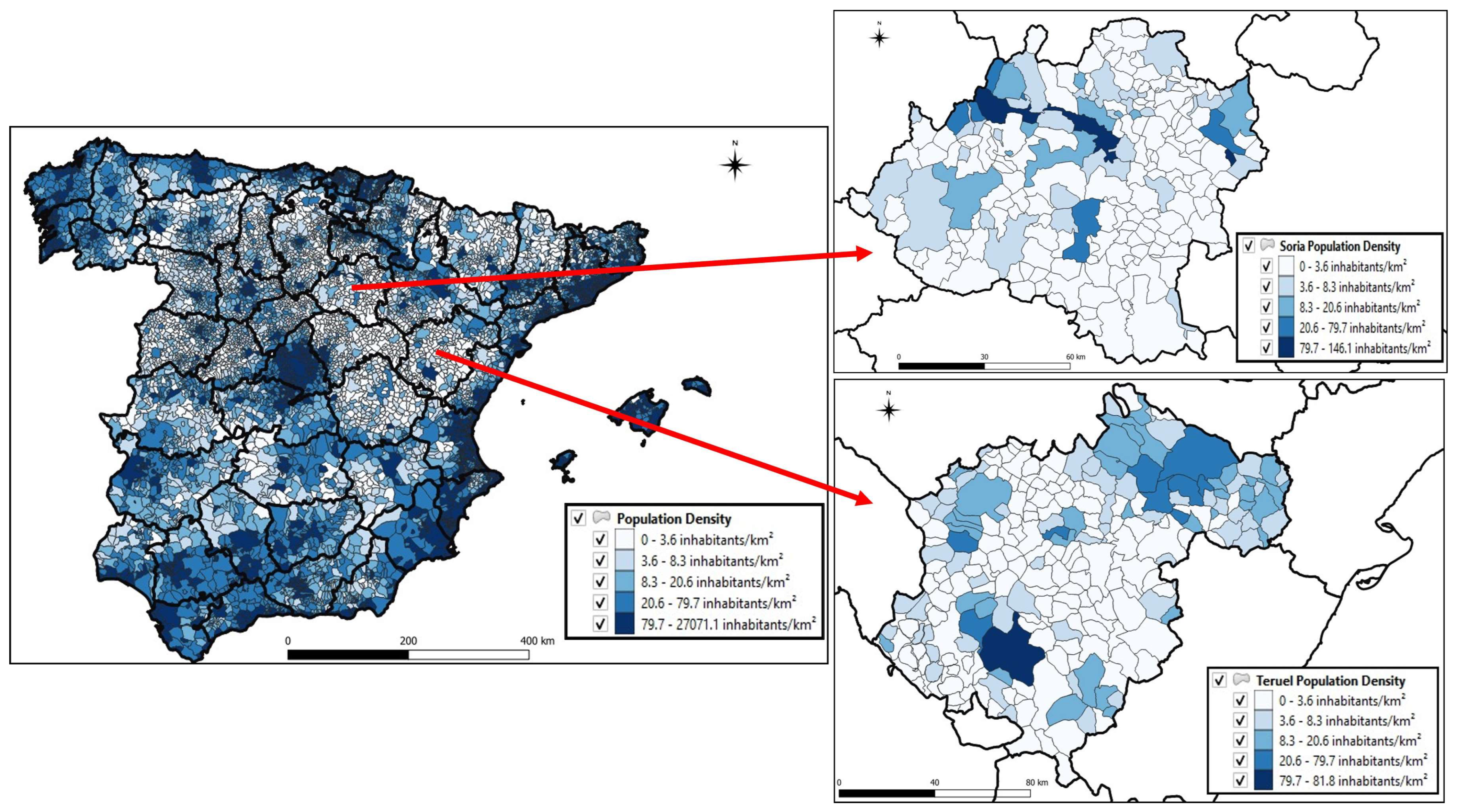
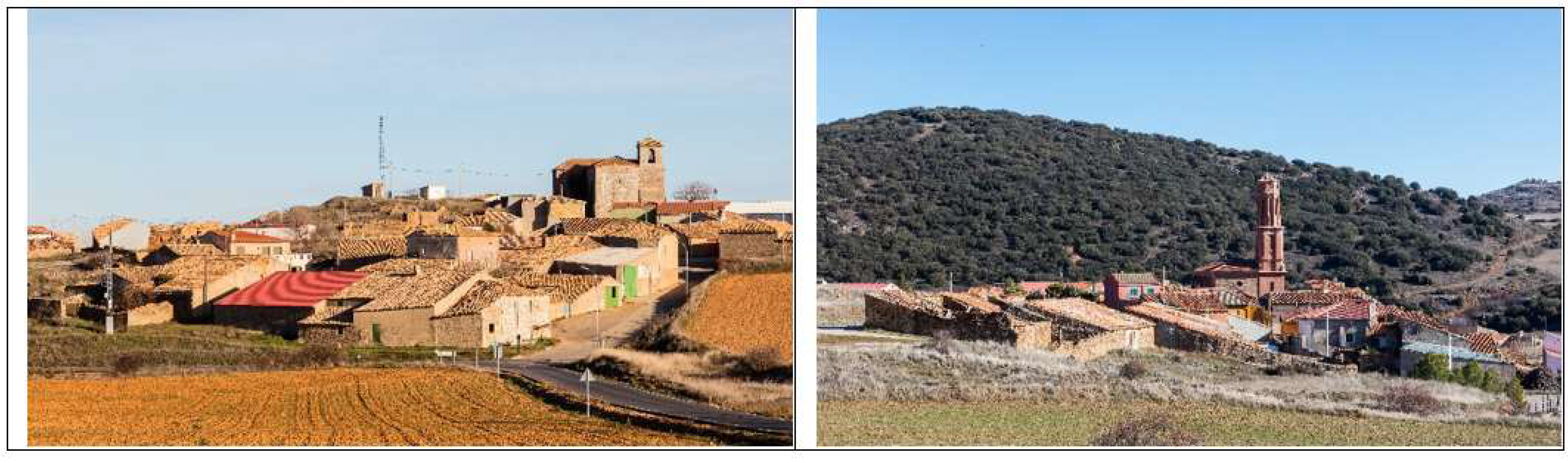
2.1. Study Area

In Spain, according to the National Institute of Statistics (INE) [31], the threshold differentiating an urban from a rural municipality is 10,000 inhabitants. In the provinces of Soria and Teruel, located in the autonomous communities of Castilla y León and Aragón, respectively, almost the entire area is dominated by settlements classified as rural. As can be seen in Table 1, there is just one municipality in Soria and two in Teruel with over 10,000 inhabitants. The former (the town of Soria) contains 44% of the provincial population, and the latter (the towns of Teruel and Alcañiz) contains 38%; these urban municipalities are the only ones in which population has increased.
These two provinces have the lowest population density in Spain. In 2018, they were within the NUTS 3 regions of Europe with the lowest inhabitants per square kilometer at about 8.7 inhabitants/km2 in the case of Soria and 9 inhabitants/km2 for Teruel [27]. These figures highlight a population density that has remained stable over time at a level almost 13 times lower than the European average (Table 2), and almost 9 times lower than the average for Spain (Figure 1). At the municipal level, much lower values can be found; for example, the municipality of Estepa de San Juan in Soria, which in 2018 had a population density of 0.57 inhabitants/km2, figures that crop up again and again in numerous municipalities in the two provinces. This has led some authors to dub these areas as “the Spanish Lapland” [32].
The provinces of Soria and Teruel are situated in the northeast of the Iberian Peninsula and cover a surface area of 10,306 km2 and 14,809 km2, respectively. Although Teruel is more mountainous than Soria, they both have average altitudes of around 1000 m, and a warm temperate climate, with average temperatures ranging between 2 °C in the winter and 23 °C in the summer; the annual rainfall is around 500 mm. Their main economic activities are the cultivation of cereals on rainfed land, together with tourism, the agrifood industry, and the energy sector, as well as the furniture industry in Soria or coal mining, on the verge of disappearing, in Teruel (Figure 2) ([33], Diego Delso).
While in many other Spanish regions, people migrated from rural areas to their provincial capitals, in the provinces we studied, this trend was not followed, or at least not to the same degree. This is due to the lack of basic services in the cities of Soria and Teruel such as further education facilities, a range of leisure options for local people, a broad variety of retail outlets, and certain medical specialties. As a result, many inhabitants of these cities also decided to leave.
Emigrants from these areas moved primarily to Madrid during a significant period of development in industry, retail, the service sector, and public administration. The second most popular destination was Zaragoza, the capital of Aragon, due to its proximity to both Teruel and Soria and to the establishment of a development hub during the Economic and Social Development Plan implemented in Spain between 1964 and 1967. The flow of people to Madrid and Zaragoza remains important today, although it is now more closely associated with the tertiary sector [34].

2.2. Data and Methods
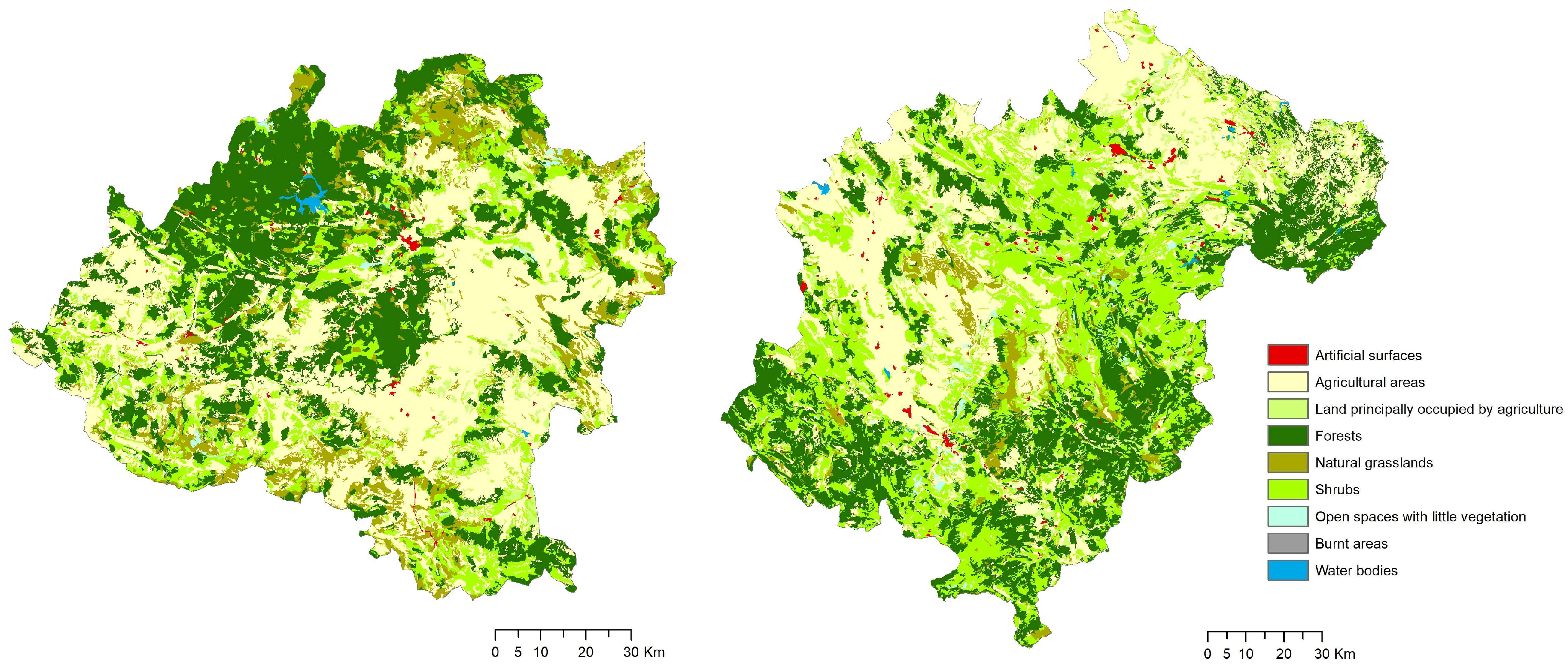
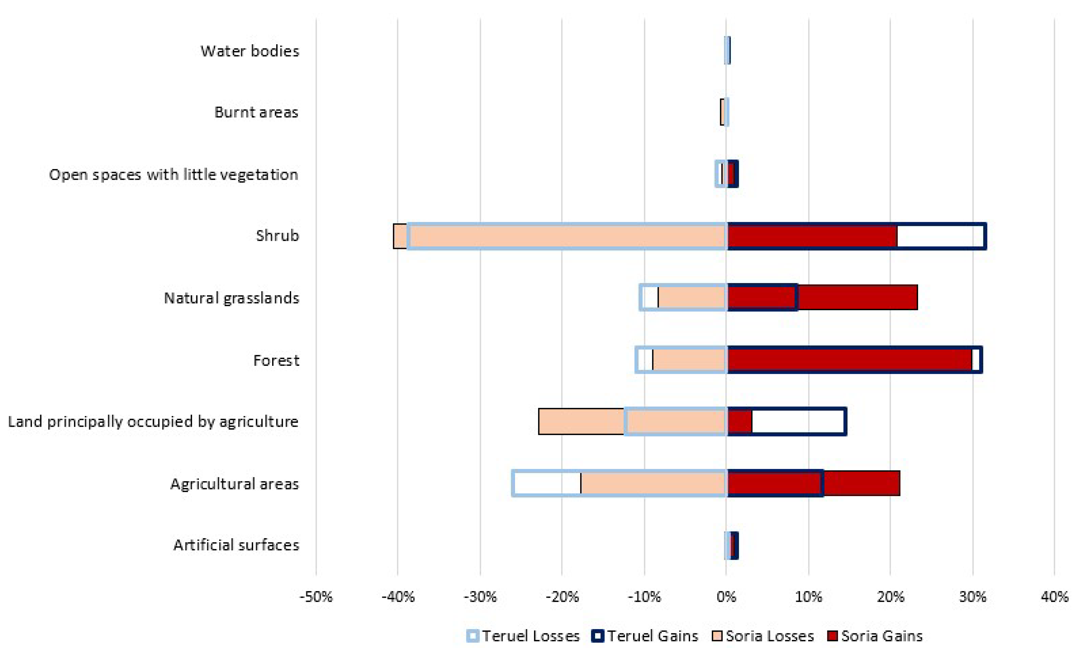
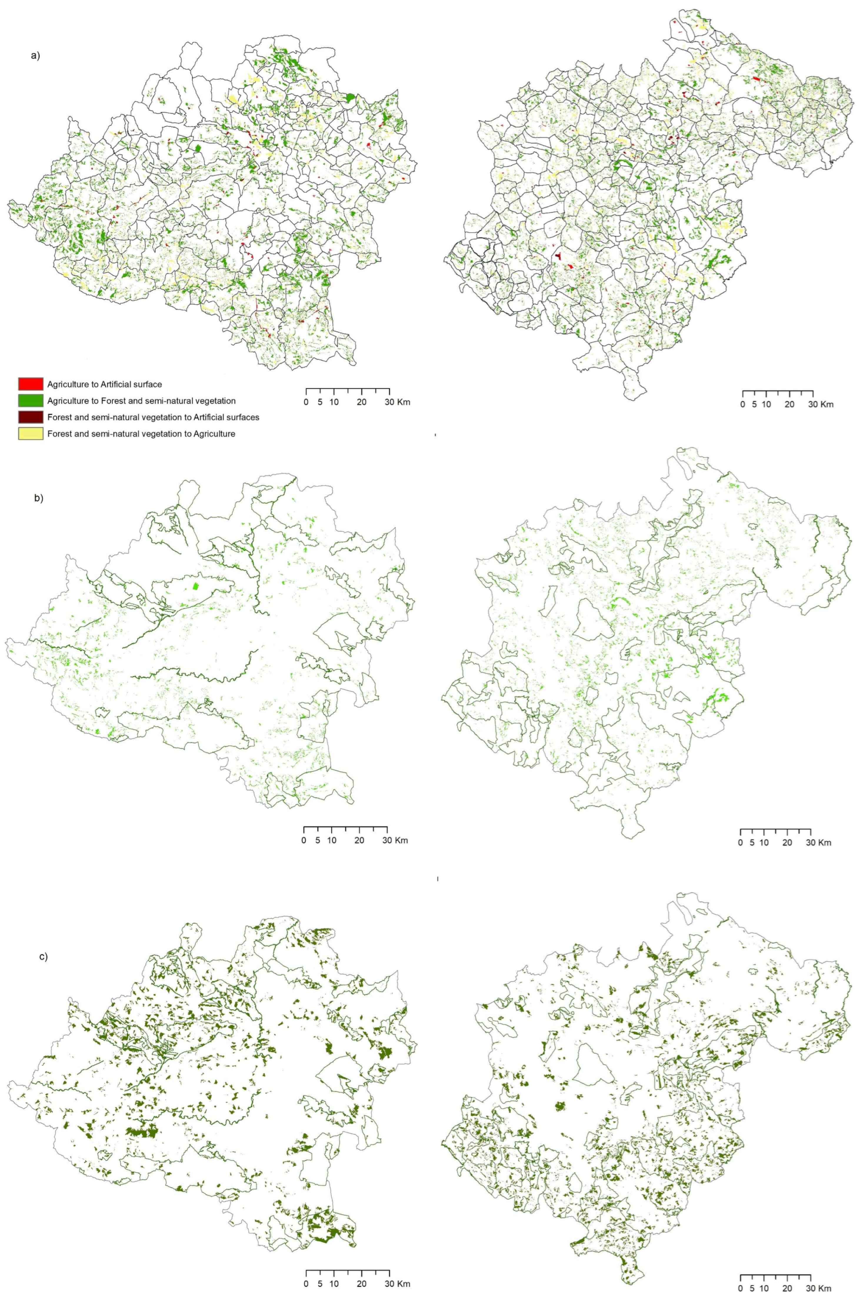
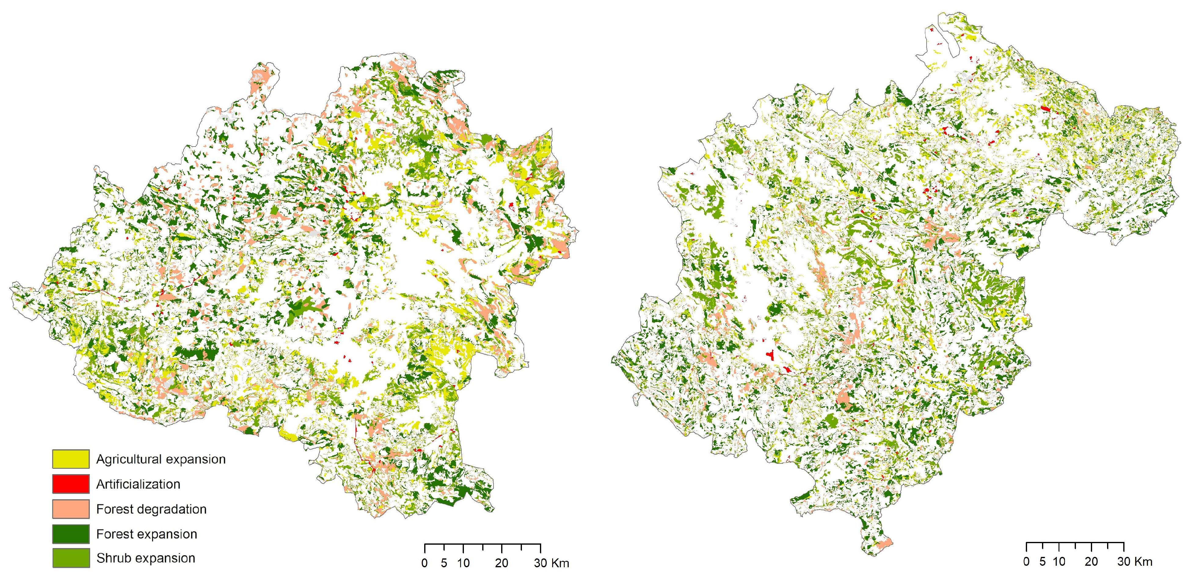
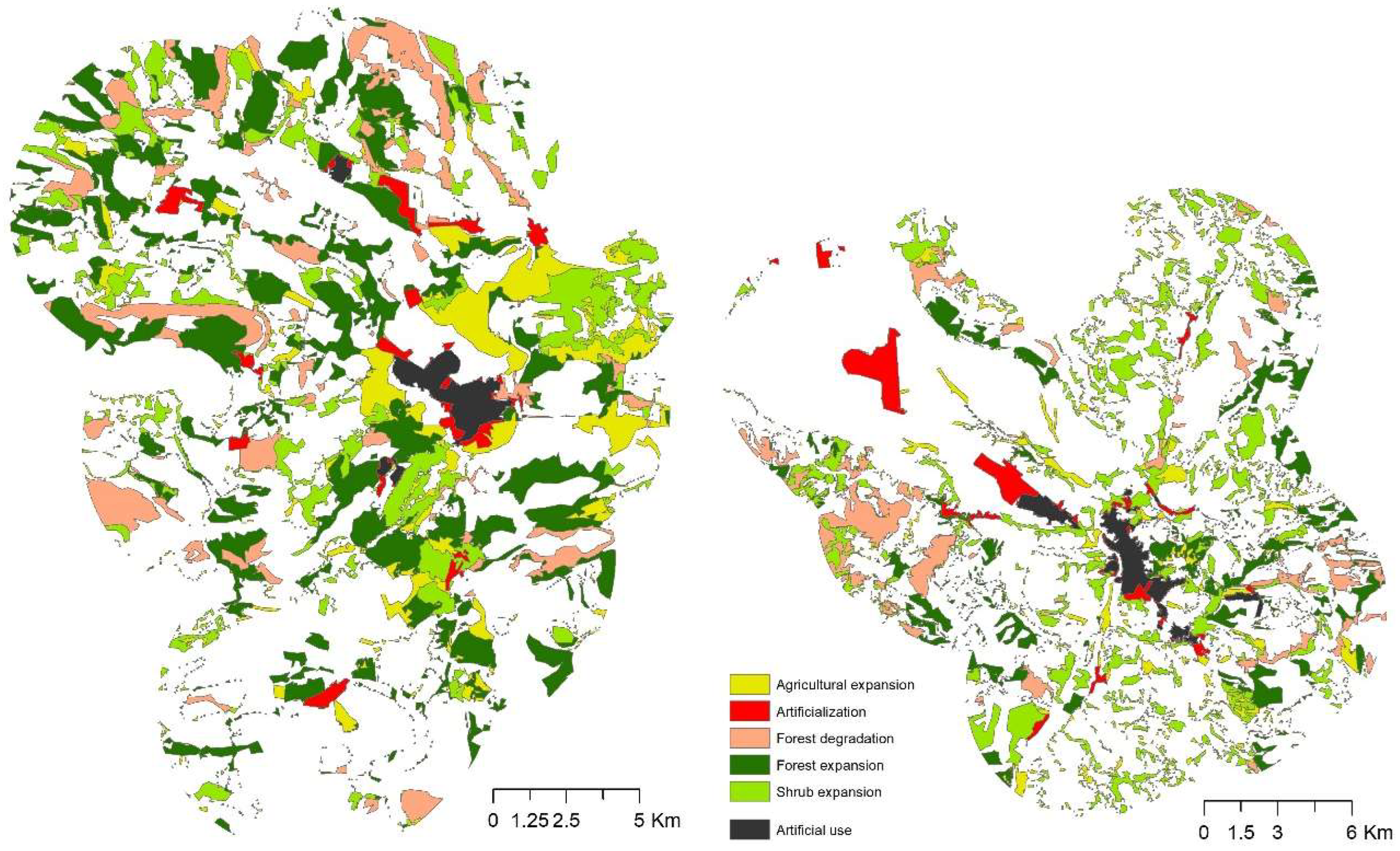
In our analysis of land use changes, we have used the CORINE Land Cover (CLC) database at a scale of 1:100,000 for the years 2000, 2012, and 2018. The information was downloaded from the National Geographical Information Centre of the Spanish National Geographic Institute [35]. The ArcGis 10.8 [36] and IDRISI TerrSet 18 software packages [37] were also used. Data from 2000 to 2018 were used to obtain land use and land cover changes, while data from 2012 were used to calibrate the processes of arable land abandonment and rewilding via the random selection of different parcels of land, so preventing them from being confused with fallow land. We also used spatial information relating to the Natura 2000 Network and other protected natural spaces in both provinces, at a scale of 1:50,000, provided by the Ministry for the Ecological Transition and the Demographic Challenge [38].
The legend at Level 3 of the CLC, which has 27 different categories in the case of Soria and 31 in that of Teruel, was reclassified into 17 and 9 categories, respectively, in order to be able to observe the changes that have taken place in natural and farm land (Table 3 and Figure 3).
After performing a rasterization of the original vector format with a pixel size of 50 m, crosstabulations were carried out [39] (see Supplementary Material, Tables S1 and S2), so obtaining some descriptive statistics about land use changes (gains, losses, swaps, net change, and gross change).
Land use change maps were also drawn up so that we could later focus on the following processes of change: artificialization; shrub expansion; forest expansion; agricultural expansion; and forest degradation. The processes of change were expressed by grouping together the crosses obtained with the categories listed in Table 3. Artificialization can be defined as all the land uses which change to urban and/or industrial uses; shrub expansion as all the agricultural land uses which change to shrubs or natural grasslands, and also those that change from natural grasslands to shrubs; forest expansion as land that changes to forest at the expense of agricultural uses, natural grasslands, shrubs, or burnt areas; agricultural expansion as natural grasslands, shrubs, and forests that change to farmland or agriculture with vegetation; and forest degradation refers to land which was previously forest and has now become shrubland or natural grasslands.

3. Results

It should provide a concise and precise description of the experimental results, their interpretation, as well as the experimental conclusions that can be drawn.
In the provinces of Soria and Teruel, the uses and covers with the largest surface areas are agriculture, forest, and shrub. If we observe the changes over the study period (Figure 4), we can see that the main swaps have taken place between these same uses and covers. The greatest losses were recorded by shrub (~40%), followed in the case of Soria by land principally occupied by agriculture (~25%), and in the case of Teruel by agricultural areas (~27%). In regard to gains, the greatest gains occurred in shrub (a cover in which there were large swaps) and in forest in Teruel (~32%), and in the case of Soria, most noticeably in forest (~30%), natural grasslands (~24%), and agricultural areas (~21%). Despite the depopulation they have suffered, the artificial areas (urban, industrial, and retail areas) have grown, albeit very slightly, with an increase of 3233 Ha in Soria and 5724 Ha in Teruel, equivalent to 0.38 and 0.31% of their respective territories. In both provinces, this artificialization has occurred all around the most populated towns.
These changes took place across the whole territory of both provinces (Figure 5). The top two maps (Figure 5a) show the main transitions: agriculture to artificial surface; agriculture to forest and semi-natural vegetation; forest and semi-natural vegetation to artificial surface; and forest and semi-natural vegetation to agriculture. The change from agriculture to forest and semi-natural vegetation (shaded in green) is the one that occupies the largest area (between 6% and 8% of the total) in both provinces, located above all in the north, west, and southeast of the province of Soria and throughout the entire territory of the province of Teruel.
The maps in the middle (Figure 5b) and at the bottom (Figure 5c) highlight the locations of the changes from agricultural land to shrub and from shrub to forest, respectively, in Soria and Teruel, with the Natura 2000 layer superimposed. In Soria, the change from agricultural land to shrub is mainly located in northern and western parts of the province, while in Teruel the largest patches are located in the center and east. In regard to the change from shrub to forest (Figure 5c), in Soria this change is located above all in the northwest and southeast of the province, while in Teruel there is a clear strip running from the southwest to the center and various scattered patches.
In this way, of the processes that have taken place in these last two decades (Figure 6 and Table 4), perhaps the most important are the agricultural expansion in Soria (7.4% of its territory) in the northeast and east, while in Teruel (4.7%) this happens in smaller, more scattered patches in the north and center-east of the province. The areas affected by forest degradation occupy 7.1% and 3.9% of the total area in Soria and Teruel, respectively, located in homogeneous patches in the north and southeast (Soria) and the center (Teruel). Forest expansion has happened above all in the large areas of forests in the northwest of Soria (10%), and in areas previously occupied by shrubs to the northeast of Teruel (8.9%). Finally, shrub expansion has occurred in areas near the agricultural areas in the north and southwest of Soria, while in Teruel there are large patches running from west to east in the central part of the province, and near agricultural areas and close to a patch of forest (East). This change occupies 8.3% and 10% of the total area in Soria and Teruel, respectively.
As mentioned earlier, artificialization has taken place in the most populated urban environments. This slight dynamism (around 0.35% of its territory) occurs above all near the city of Soria and the city of Teruel, and their surrounding areas (Figure 7).
In short, the land use changes and processes that took place in the last two decades in the two provinces are very similar. The main processes were shrub and forest encroachment, taking up almost 20% of the change in both territories. The main change is from agriculture to forest and semi-natural vegetation and from natural grasslands and shrubs to forest, which each accounted for just over 7% of the territory. The change processes in agricultural areas and agriculture with vegetation to forest and from agricultural areas to shrub each represent around 2% of the territory.

4. Discussion

The regions with the highest probability of farmland abandonment are typically amongst those with the highest unemployment rates and a high negative migration. The areas analyzed in this study have some of the lowest population densities in Spain, comparable with those in areas in the far North of Europe. They are vulnerable to negative processes such as abandonment because of their particular socioeconomic characteristics (Figure 8). These include the loss of population and the resulting drop in population density, the high average age of those who remain, a reduced diversification of the types of work associated with rural areas, and a lack of job opportunities, all of which lead more people to abandon these areas. This gives rise to significant changes in the landscape and in land uses, a process which, in Spain, far from improving is become more and more serious as time goes by [40].
In addition to other socioeconomic and biophysical factors, other studies in various regions of Western, Central, and Southern Europe highlight the relationship between depopulation and changes in the landscape, as manifested in the abandonment of land [4,41,42] and sometimes even of entire villages.
Figure 8. Buimanco, a village in the province of Soria abandoned in 1965. Reprinted with permission from [43].
Land 12 01967 g008
According to Levers et al. [2], the abandonment of farming in Europe between 2001 and 2012 was an infrequent event, contrary to the trend we observed in the provinces of Soria and Teruel, where there was quite a high percentage of change, of around 9% in both provinces, in spite of the fact that rural population decline slowed down due to the arrival of foreign immigrants during this period [44]. However, at the same time, a converse process of expansion of agriculture was taking place above all in Soria, in 7% of its total area, indicating changes in the location of farmland. Nowadays, the location of croplands in Southern Europe does not depend so much on physical or biophysical factors, and there is an increasing tendency to locate farms in more degraded areas and with a low water capacity, a long way from cities and markets [45]. This was highlighted in a study in Spain by Bakker and Veldkamp [46], who found that factors such as topography, soil quality, and accessibility have become less important in the location of cropland, and crop cultivation is increasingly concentrated in warm and sunny areas where high production is ensured with the help of modern technology such as irrigation and land levelling, as is happening in the south and southeast of the Iberian Peninsula with the aid of greenhouse and drip irrigation techniques [47]. In the provinces we studied, we did not detect higher levels of abandonment around the cities as had been noted by Bakker et al. [45]; in fact, in Soria, there has been an expansion in agriculture around the city, and nor did we notice lower levels of abandonment within the Natura 2000 network in relation to conservation policies for the maintenance of sustainable agriculture, as reported by Levers et al. [2].
In regard to the planning of these territories, which are suffering high rates of agricultural abandonment and naturalization of the landscape, there is a debate between the loss of traditional landscapes and the potentially positive impacts of rewilding on biodiversity and ecosystem services (e.g., water regulation and supply, food production, aesthetic value, recreational services, etc.) [14,48,49]. By contrast, other authors stress the link between rural depopulation and environmental sustainability [26], arguing that if the land is abandoned there are greater environmental risks, such as soil erosion, an increase in the number of forest fires, and the deterioration or loss of both natural heritage and historic, artistic, and cultural heritage [50,51,52]. Others contend that abandonment is one of the main threats to the bio-cultural heritage in European landscapes [52,53,54,55].
There is, therefore, a need to manage the territory, even when it is completely uninhabited, a situation that may eventually be reached in these regions if the population decline initiated in the 1950s continues. The scientific community shows a lack of consensus on how best to proceed in these cases. Lasanta et al. [50] observed that society and scientists are divided on how to manage abandoned lands. Some think that passive management of the revegetation process is required in order to restore natural ecosystem processes and reduce human control over the landscape. Other scientists and some parts of the population propose interventions in the landscape. They argue that in the present context of widespread land abandonment, degradation of the landscape, less biodiversity, and a loss of resources and ecosystem services, alternatives for managing abandoned farmland must be proposed in order to mitigate the negative effects of revegetation processes. In addition, the perceptions regarding the value of these landscapes vary depending on whether you are a resident or a tourist; in a study carried out by Höcht et al. [12] in the Alps, they found that just 6% of local residents wanted “more forest and dense shrublands”, as for them this was synonymous with a scruffy, dirty, or forgotten landscape, while the visitors considered wildness to be a positive aspect, but also regretted the cultural losses.
For all these reasons, policies and governance are fundamental. Subsidies or support for public policies using financial and other kinds of resources can function as facilitators of adaptation or as limiters, and therefore play a key role when it comes to effectively reducing the vulnerability of rural areas [15]. However, Alonso-Carrillo et al. [23] observed that the policies that have been implemented, such as the CAP, LEADER programs, or the rural policies designed in recent years by the Spanish Government, have not been successful at tackling social and economic deprivation in lagging rural areas. In this sense, the opinions of stakeholders about the policies and the future development of territories that are suffering depopulation can vary according to the size of the town or village in which they live: inhabitants of small towns consider that policies focused on improving infrastructures are the most appropriate for the long-term solution of the depopulation problem, while people from rural municipalities in the heart of depopulated Spain believe that the solution cannot be achieved in the medium term, but they are confident that in the long term a solution will be found [23]. Accessibility, facilities, economic conditions, population ageing, natural amenities, and the degree of urbanization are all identified as factors to be considered and monitored in any regional strategy in response to demographic challenges [56].
Lastly, it is important to take into account that our study has a number of limitations. As has been demonstrated on numerous occasions, the CORINE database has errors and uncertainties resulting from changes in the methodology [57]. The scale at which we conducted this research could be considered too broad in spatial terms. There could also be certain errors in terms of the land parcels where agriculture has been deemed to have been abandoned, but which may in fact be fallow fields (even though we tried to avoid this problem by using the CLC for the year 2012). In a study of 11 sites in different parts of the world, Crawford et al. [49] showed that abandoned croplands are soon recultivated, typically within 30 years of their initial abandonment at almost all the sites they studied. This means that a broader timeframe might perhaps be more suitable, as well as a greater level of detail.
A statistical analysis of the factors behind the different changes and processes analyzed would have facilitated their explanation, and this will be a question for future research. However, as Bakker and Veldkamp [46] point out, it is also necessary to take into account that the relationships between land use and the environment in Spain are nonstationary in time, and new constraints may develop which are not yet reflected in the recently observed changes.

5. Conclusions

LULC analysis helps us to understand the relations between the activities carried out by the population of a particular territory and the possible consequences arising from these relations, making it possible to draw up territorial management plans and design policies. As Pelorosso et al. [58] stated, landscapes made up of abandoned farmland need effective management to maintain their functionality to support sustainable development.
The land use changes that have taken place in the last two decades in Soria and Teruel are related with the processes of extensification and of shrub and forest encroachment, (taking up almost 50% of the change in both territories) caused in part by people abandoning rural areas. These two cases are of particular interest because unlike other areas, their low population density figures, some of the lowest in Europe, are not due to extreme climatic conditions or remote locations in isolated mountainous areas. They should not therefore be viewed as marginal areas but as inland country areas with an evident depopulation problem.
It seems likely that the trend will continue in the coming years in spite of the fact that depopulation has recently become a priority on the Spanish political agenda, and a specific Ministry for the Ecological Transition and the Demographic Challenge has been set up. This ministry is responsible for implementing specific measures in the areas most affected by territorial inequality. In addition to trying to address the social and economic issues caused by depopulation, the main focus in past decades, the interest today has shifted to include ways of dealing with its environmental consequences.
It is therefore very important to know what is happening with land use in these areas and what may happen in the future. Depopulation will remain an issue in the coming years, and this will affect the social, economic, and environmental activity in these areas. The continuing exodus from the countryside has important consequences, such as (a) the abandonment of crops, pastures, and forests due to the lack of generational replacement or of other people who can tend to them; (b) the degradation and loss of traditional agrarian landscapes, in which the historic and cultural elements typical of these landscapes are also inevitably affected; (c) the creation of new farming landscapes resulting from the increasing concentration of land ownership in the hands of just a few farmers, with more homogenized farms and more intensive use of the soil; (d) the extension of shrubs across ever greater spaces with an increase in the density, cover, and biomass of autochthonous woody plants or bushes and a possible increase in forest fires due to the fact that there are not enough people working in and looking after the mountains and forests, among others.

Supplementary Materials

The following supporting information can be downloaded at: https://www.mdpi.com/article/10.3390/land12111967/s1, Table S1. Land use/land cover transition matrix in hectares. 2000–2018. Soria; Table S2. Land use/land cover transition matrix in hectares. 2000–2018. Teruel.

Author Contributions

Conceptualization, M.G. and D.C.; methodology, M.G., J.F.-P. and D.C.; formal analysis, M.G. and J.F.-P.; writing—original draft, M.G., J.F.-P., D.C. and L.V.; writing—review and editing, M.G., J.F.-P., D.C. and L.V. All authors have read and agreed to the published version of the manuscript.

Funding

This research was supported by Ayudas a Investigadores Tempranos UNED-Santander 2022 (2022V/ITEMP/008).

Data Availability Statement

The data presented in this study are available on request form the corresponding author.

Acknowledgments

We would like to thank the reviewers for their time and effort in revising this paper.

Conflicts of Interest

The authors declare no conflict of interest.

References

  1. Winkler, K.; Fuchs, R.; Rounsevel, M.; Herold, M. Global land use changes are four times greater than previously estimated. Nat. Commun. 2021, 12, 2501. [Google Scholar] [CrossRef] [PubMed]
  2. Levers, C.; Schneider, M.; Prishchepov, A.V.; Estel, S.; Kuemmerle, T. Spatial variation in determinants of agricultural land abandonment in Europe. Sci. Total Environ. 2018, 644, 95–111. [Google Scholar] [CrossRef] [PubMed]
  3. Otero, I.; Marull, J.; Tello, E.; Diana, G.L.; Pons, M.; Coll, F.; Boada, M. Land abandonment, landscape, and biodiversity: Questioning the restorative character of the forest transition in the Mediterranean. Ecol. Soc. 2015, 20, 15. [Google Scholar] [CrossRef]
  4. Latocha, A.; Reczyńska, K.; Gradowski, T.; Świerkosz, K. Landscape memory in abandoned areas—Physical and ecological perspectives (Central European mountains case study). Landsc. Res. 2019, 44, 600–613. [Google Scholar] [CrossRef]
  5. MacDonald, D.; Crabtree, J.R.; Wiesinger, G.; Dax, T.; Stamou, N.; Fleury, P.; Gutierrez Lazpita, J.; Gibon, A. Agricultural abandonment in mountain areas of Europe: Environmental consequences and policy response. J. Environ. Manag. 2000, 59, 47–69. [Google Scholar] [CrossRef]
  6. Chauchard, S.; Carcaillet, C.; Guibal, F. Patterns of land-use abandonment control tree-recruitment and forest dynamics in Mediterranean mountains. Ecosystems 2007, 10, 936–948. [Google Scholar] [CrossRef]
  7. Varga, D.; Subirós, J.V.; Barriocanal, C.; Pujantell, J. Landscape Transformation under Global Environmental Change in Mediterranean Mountains: Agrarian Lands as a Guarantee for Maintaining Their Multifunctionality. Forests 2018, 9, 27. [Google Scholar] [CrossRef]
  8. Serra, P.; Vera, A.; Tulla, A.F.; Salvati, L. Beyond urban-rural dichotomy: Exploring socioeconomic and land-use processes of change in Spain. Appl. Geogr. 2014, 55, 71–81. [Google Scholar] [CrossRef]
  9. Montiel-Molina, C.; Vilar, L.; Romão-Sequeira, C.; Karlsson, O.; Galiana-Martín, L.; Madrazo-García de Lomana, G.; Palacios-Estremera, M.T. Have Historical Land Use/Land Cover Changes Triggered a Fire Regime Shift in Central Spain? Fire 2019, 2, 44. [Google Scholar] [CrossRef]
  10. Vadell, E.; De Miguel, S.; Pemán, J. Large-scale reforestation and afforestation policy in Spain: A historical review of its underlying ecological, socioeconomic and political dynamics. Land Use Policy 2016, 55, 37–48. [Google Scholar] [CrossRef]
  11. Marey-Pérez, M.; Rodríguez-Vicente, V. Forest transition in Northern Spain: Local responses on large-scale programmes of field-afforestation. Land Use Policy 2009, 26, 139–156. [Google Scholar] [CrossRef]
  12. Höchtl, F.; Lehringer, S.; Konold, W. “Wilderness”: What it means when it becomes a reality: A case study from the southwestern Alps. Landsc. Urban Plan. 2005, 70, 85–95. [Google Scholar] [CrossRef]
  13. Pereira, E.; Queiroz, C.; Pereira, H.M.; Vicente, L. Ecosystem services and human well-being: A participatory study in a mountain community in Portugal. Ecol. Soc. 2005, 10, 14. [Google Scholar] [CrossRef]
  14. Van der Zanden, E.H.; Verburg, P.H.; Schulp, C.J.E.; Verkerk, P.J. Trade-offs of European agricultural abandonment. Land Use Policy 2017, 62, 290–301. [Google Scholar] [CrossRef]
  15. Facchini, F.; Villamayor-Tomas, S.; Corbera, E.; Ravera, F.; Pocull-Bellés, G.; Codina, G.L. Socio-ecological vulnerability in rural Spain: Research gaps and policy implications. Reg. Environ. Chang. 2023, 23, 26. [Google Scholar] [CrossRef]
  16. Lomba, A.; Moreira, F.; Klimek, S.; Jongman, R.H.; Sullivan, C.; Moran, J.; Poux, X.; Honrado, J.P.; Pinto-Correia, T.; Plieninger, T.; et al. Back to the Future: Rethinking Socioecological Systems Underlying High Nature Value Farmlands. Front. Ecol. Environ. 2020, 18, 36–42. [Google Scholar] [CrossRef]
  17. Cuadrado, S.; Durà, A.; Estalella, H. La transformación de los asentamientos en el litoral turístico catalán: Análisis cartográfico y estadístico del Alt Empordà. Investig. Geográficas 2006, 40, 159–182. [Google Scholar] [CrossRef]
  18. Acosta, J.A.; Faz, A.; Martínez-Martínez, S. Crecimiento urbano e industrial en la ciudad de Murcia y alrededores entre 1956 y 1999: Cambios en los usos del suelo. In Tendencias Actuales de la Ciencia del Suelo; Bellifante, N., Jordán, A., Eds.; Universidad de Sevilla: Sevilla, Spain, 2007; pp. 895–901. [Google Scholar]
  19. Valera, A. Dinámica Espacio-Temporal de Usos/Cubiertas del Suelo Y Sostenibilidad Ambiental en Áreas Metropolitanas de la Comunidad Valenciana. Ph.D. Thesis, Universitat de València, Valencia, Spain, 2011. [Google Scholar]
  20. Kander, A.; Malanima, P.; Warde, P. Power to the People Energy in Europe over the Last Five Centuries; Princeton University Press: Princeton, NJ, USA, 2013. [Google Scholar]
  21. Warde, P. Firewood consumption and energy transition: A survey of sources, methods and explanations in Europe and North America. Hist. Agrar. 2019, 77, 7–32. [Google Scholar] [CrossRef]
  22. Frutos Mejías, L.M.; Solans Castro, M.; Chueca Diago, M.C. Cambios en el sistema de asentamientos rurales: La provincia de Teruel. Geographicalia 1994, 31, 83–94. [Google Scholar] [CrossRef]
  23. Alonso-Carrillo, I.; Pérez-Morote, R.; Núñez-Chicharro, M.; Pontones-Rosa, C. Do citizens in Spanish municipalities have the same perception of the solution to depopulation? Influence of population size. Cities 2023, 135, 104210. [Google Scholar] [CrossRef]
  24. Pausas, J.G.; Fernández-Muñoz, S. Fire Regime Changes in the Western Mediterranean Basin: From Fuel-Limited to Drought-Driven Fire Regime. Clim. Chang. 2012, 110, 215–226. [Google Scholar] [CrossRef]
  25. Quintas-Soriano, C.; Castro, A.J.; Castro, H.; García-Llorente, M. Impacts of Land Use Change on Ecosystem Services and Implications for Human Well-Being in Spanish Drylands. Land Use Policy 2016, 54, 534–548. [Google Scholar] [CrossRef]
  26. Gómez Valenzuela, V.; Holl, A. Growth and decline in rural Spain: An exploratory analysis. Eur. Plan. Stud. 2023. [Google Scholar] [CrossRef]
  27. EUROSTAT. Population Density by NUTS 3 Region. Data Browser. Available online: https://ec.europa.eu/eurostat/databrowser/view/DEMO_R_D3DENS/default/table?lang=en (accessed on 17 June 2023).
  28. Palacios, A.; Pinilla Navarro, V.J.; Saéz Pérez, L.A. La Despoblación en Aragón, 2000–2016: Tendencias, Datos Y Reflexiones Para el Diseño de Políticas; Documentos de Trabajo; Universidad de Zaragoza: Zaragoza, Spain, 2017. [Google Scholar]
  29. Rico González, M. El fenómeno de la despoblación rural en Castilla y León: Implicaciones desde la perspectiva socioeconómica. Práctica Urbanística Rev. Mens. De Urban. 2020, 162, 13–32. [Google Scholar]
  30. Vidal Domínguez, M.J.; Fernández Portela, J. El reto demográfico en Castilla y León (España): Una región desequilibrada y envejecida poblacionalmente. Perspect. Geográfica Rev. Del Programa De Estud. De Posgrado En Geogr. 2022, 27, 76–100. [Google Scholar] [CrossRef]
  31. INE. Instituto Nacional de Estadística. Datos de Demografía y Población. Available online: https://www.ine.es/index.htm (accessed on 3 April 2023).
  32. Cerdá, P. Los Últimos. Voces de la Laponia Española; Pepitas de Calabaza: Logroño, Spain, 2019. [Google Scholar]
  33. SIDAMUN. Sistema Integrado de Datos Municipales. Ministerio Para la Transición Ecológica y el Reto Demográfico. Available online: https://public.tableau.com/views/SistemaIntegradodeDatosMunicipales/Portada?:language=es-ES&:display_count=n&:origin=viz_share_link?:showVizHome=no (accessed on 3 April 2023).
  34. Alonso Santos, J.L. Las políticas de industrialización y su impacto en el desarrollo de las regiones en España. Investig. Geográficas 2000, 42, 109–133. [Google Scholar] [CrossRef]
  35. CNIG. National Geographical Information Centre of the Spanish National Geographic Institute. Available online: https://www.ign.es/web/qsm-cnig (accessed on 24 February 2023).
  36. Hernández-Madrigal, V.M.; Muñiz-Jáuregui, J.A.; Garduño-Monroy, V.H.; Flores-Lázaro, N.; Figueroa-Miranda, S. ESRI (2011): ArcGIS Desktop: Release 10; Environmental Systems Research Institute: Redlands, CA, USA, 2011. [Google Scholar]
  37. Clark Labs Clark University USA (2018): TerrSet Geospatial Monitoring and Modeling Software. Available online: https://clarklabs.org/terrset/ (accessed on 24 February 2023).
  38. Ministry for the Ecological Transition and the Demographic Challenge. Available online: https://www.miteco.gob.es/es/cartografia-y-sig/ide/descargas/ (accessed on 24 February 2023).
  39. Pontius, R.G.; Shusas, E.; McEachern, M. Detecting important categorical land changes while accounting for persistence. Agric. Ecosyst. Environ. 2004, 101, 251–268. [Google Scholar] [CrossRef]
  40. García Marín, R.; Espejo Marín, C. El círculo vicioso de la despoblación en el medio rural español: Teruel como caso de estudio. Estud. Geográficos 2019, 80, 9. [Google Scholar]
  41. Foucher, A.; Evrard, O.; Chabert, C.; Cerdan, O.; Lefèvre, I.; Vandromme, R.; Salvador-Blanes, S. Erosional response to land abandonment in rural areas of Western Europe during the Anthropocene: A case study in the Massif-Central, France. Agric. Ecosyst. Environ. 2019, 284, 106582. [Google Scholar] [CrossRef]
  42. Kiziridis, D.A.; Mastrogianni, A.; Pleniou, M.; Karadimou, E.; Tsiftsis, S.; Xystrakis, F.; Tsiripidis, I. Acceleration and relocation of adornment in a Mediterranean mountainous landscape: Drivers, consequences and management implications. Land 2022, 11, 406. [Google Scholar] [CrossRef]
  43. Abandonados al Silencio. Available online: http://abandonadosalsilencio.blogspot.com/2015/12/buimanco.html (accessed on 18 September 2023).
  44. Palacios, A.; Pinilla, V.; Silvestre, J. Emigrating to Depopulated Regions in Mediterranean Europe: Demographic Impact and Choice of Destination in a Case Study in North-East Spain (Aragon). Eur. Countrys. 2022, 14, 258–280. [Google Scholar] [CrossRef]
  45. Bakker, M.M.; Hatna, E.; Kuhlman, T.; Mücher, C.A. Changing environmental characteristic of European Cropland. Agric. Syst. 2011, 104, 522–532. [Google Scholar] [CrossRef]
  46. Bakker, M.M.; Veldkamp, A. Changing relationship between land use and environmental characteristics and their consequences for spatially explicit land-use change prediction. J. Land Use Sci. 2012, 7, 407–424. [Google Scholar] [CrossRef]
  47. Martínez-Vega, J.; Mili, S.; Gallardo, M. Modelling land use and land cover in the Mediterranean agricultural ecosystems. In Modelling for Sustainable Management in Agriculture, Food and the Environment; Vlonzos, G., Ampatzidis, Y., Manos, B., Pardalos, P., Eds.; CRC Press Taylor & Francis: Boca Raton, FL, USA, 2022; pp. 40–73. [Google Scholar] [CrossRef]
  48. Bruno, D.; Sorando, R.; Álvarez-Farizo, B.; Castellano, C.; Céspedes, V.; Gallardo, B.; Jiménez, J.J.; López, M.V.; López-Flores, R.; Moret-Fernández, D.; et al. Depopulation impacts on ecosystem services in Mediterranean rural areas. Ecosyst. Serv. 2021, 52, 101369. [Google Scholar] [CrossRef]
  49. Crawford, C.L.; Yin, H.; Radeloff, V.C.; Wilcove, D.S. Rural land abandonment is too ephemeral to provide major benefits for biodiversity and climate. Sci. Adv. 2022, 8, eabm8999. [Google Scholar] [CrossRef]
  50. Lasanta, T.; Nadal-Romero, E.; Arnáez, J. Managing abandoned farmland to control the impact of re-vegetation on the environment. The state of the art in Europe. Environ. Sci. Policy 2015, 52, 99–109. [Google Scholar] [CrossRef]
  51. Gallardo, M.; Gómez, I.; Vilar, L.; Martínez-Vega, J.; Martín, M.P. Impacts of future land use/land cover on wildfire occurrence in the Madrid region (Spain). Reg. Environ. Change 2016, 16, 1047–1061. [Google Scholar] [CrossRef]
  52. Ruiz Pulpon, A.; Canizares Ruiz, M. Enhancing the territorial heritage of declining rural areas in Spain: Towards integrating top-down and bottom-up approaches. Land 2020, 9, 216. [Google Scholar] [CrossRef]
  53. Plieninger, T.; Höchtl, F.; Spek, T. Traditional land-use and nature conservation in European rural landscapes. Environ. Sci. Policy 2006, 9, 317–321. [Google Scholar] [CrossRef]
  54. Plieninger, T.; Bieling, C. Resilience-based perspectives to guiding high-nature-value farmland through socioeconomic change. Ecol. Soc. 2013, 18, 20. [Google Scholar] [CrossRef]
  55. Rotherham, I.D. Bio-cultural heritage and biodiversity: Emerging paradigms in conservation and planning. Biodivers. Conserv. 2015, 24, 3405–3429. [Google Scholar] [CrossRef]
  56. Alamá Sabater, L.; Budí, V.; Roig-Tierno, N.; García-Álvarez-Coque, J.M. Drivers of depopulation and spatial interdependence in a regional context. Cities 2021, 11, 103217. [Google Scholar] [CrossRef]
  57. García-Álvarez, D.; Camacho Olmedo, M.T. Changes in the methodology used in the production of the Spanish CORINE: Uncertainty analysis of the new maps. Int. J. Appl. Earth Obs. Geoinf. 2017, 63, 55–67. [Google Scholar] [CrossRef]
  58. Pelorosso, R.; Della Chiesa, S.; Tappeiner, U.; Leone, A.; Rocchini, D. Stability analysis for defining management strategies in abandoned mountain landscapes of the Mediterranean basin. Landsc. Urban Plan. 2011, 103, 335–346. [Google Scholar] [CrossRef]
Figure 1. Population density in Soria and Teruel in 2021 at the municipal level (NUTS 5).
Land 12 01967 g001
Figure 2. Landscapes in Soria and Teruel. The picture on the left shows the village of Maján (Soria), which in 2021 had 9 inhabitants and an average age of 69.5 years old, while the one on the right shows the village of Santa Cruz de Nogueras (Teruel), with 30 inhabitants and an average age of 57.5.
Land 12 01967 g002
Figure 3. Reclassified land uses in Soria (left) and Teruel (right).
Land 12 01967 g003
Figure 4. Losses and gains recorded in Soria (in the red range of colors) and Teruel (in the blue range of colors) between 2000 and 2018, in percentages.
Land 12 01967 g004
Figure 5. Location of the main land use changes registered in Soria (left) and Teruel (right) (a): agriculture to artificial surface (red); agriculture to forest and semi-natural vegetation (green); forest and semi-natural vegetation to artificial surface (brown); forest and semi-natural vegetation to agriculture (yellow). Location of the changes from agricultural to shrub (b) and from shrub to forest (c) with the Natura 2000 network.
Land 12 01967 g005
Figure 6. Principal change processes registered in Soria (left) and Teruel (right): agricultural expansion (yellow); artificialization (red); forest degradation (pink); forest expansion (dark green); shrub expansion (light green).
Land 12 01967 g006
Figure 7. Change processes registered at a distance of 5 km from the artificial areas of the city of Soria and its surrounding area (left) and the city of Teruel and its surrounding area (right). Artificial use CLC 2000 highlighted in black.
Land 12 01967 g007
Table 1. Number of municipalities and inhabitants in the provinces of Soria and Teruel in 2000 and 2018. The places in which the population has increased are highlighted in bold type.
Population of Each MunicipalityProvince of Soria
Nº Municipalities%Population 2000%Population 2018%
Less than 10,000182 99.4556,82362.549,48855.86
More than 10,0001 0.5534,08837.539,11244.14
Total183 10090,91110088,600100
Population of Each MunicipalityProvince of Teruel
Nº Municipalities%Population 2000%Population 2018%
Less than 10,000234 127.8796,538 68.0482,52261.63
More than 10,0002 1.0943,618 31.9651,63038.37
Total236128.96136,473100134,572100
Table 2. Population density over the period 2000–2018 in Europe, Spain, and the provinces of Soria and Teruel (inhabitants per km2).
YearSoriaTeruelSpainEurope
20008.89.280.2111.9
20018.89.280.7112.1
20028.89.281.9112.4
20038.99.383.4112.8
20048.99.484.8113.2
200599.586.3113.7
200699.687.7114.1
20079.19.890.1114.7
20089.29.991.6115.1
20099.29.892.4115.4
20109.29.892.8115.7
20119.29.793.2115.7
20129.19.693.2116
20139.19.592.9116.1
201499.492.5116.9
20158.99.392.5117
20168.89.292.5117.7
20178.79.192.7117.7
20188.7993.1118
Table 3. Land use categories reclassified from CLC.
CLC Category 1Cat 2 Reclassification
Urban fabricArtificial surfaces
Other artificial uses
Non-irrigated arable landAgricultural areas
Permanently irrigated land
Vineyards
Fruit trees and berry plantations
Olive groves
Pastures
Complex cultivation patternsLand principally occupied by agriculture
Land principally occupied by agriculture, with significant areas of natural vegetation
Agro-forestry areas
ForestsForest
Natural grasslandNatural grasslands
ShrubsShrub
Open spaces with little or no vegetationOpen spaces with little or no vegetation
Burnt areasBurnt areas
Water bodiesWater bodies
Table 4. Main land use processes in Soria and Teruel, in hectares and as a percentage of total area.
ProcessesSoriaTeruel
ArtificializationHa31635392
%0.30.4
Shrub expansionHa85,103148,072
%8.310.0
Forest expansionHa103,123131,493
%10.08.9
Agricultural expansionHa76,38770,404
%7.44.8
Forest degradationHa73,22957,119
%7.13.9
Disclaimer/Publisher’s Note: The statements, opinions and data contained in all publications are solely those of the individual author(s) and contributor(s) and not of MDPI and/or the editor(s). MDPI and/or the editor(s) disclaim responsibility for any injury to people or property resulting from any ideas, methods, instructions or products referred to in the content.

