

Evolution and Transformation Analysis of Land-use in Mountainous “Granary”—Evidence from Typical Basin in Karst Mountainous Areas of Southwest China
Abstract
:1. Introduction
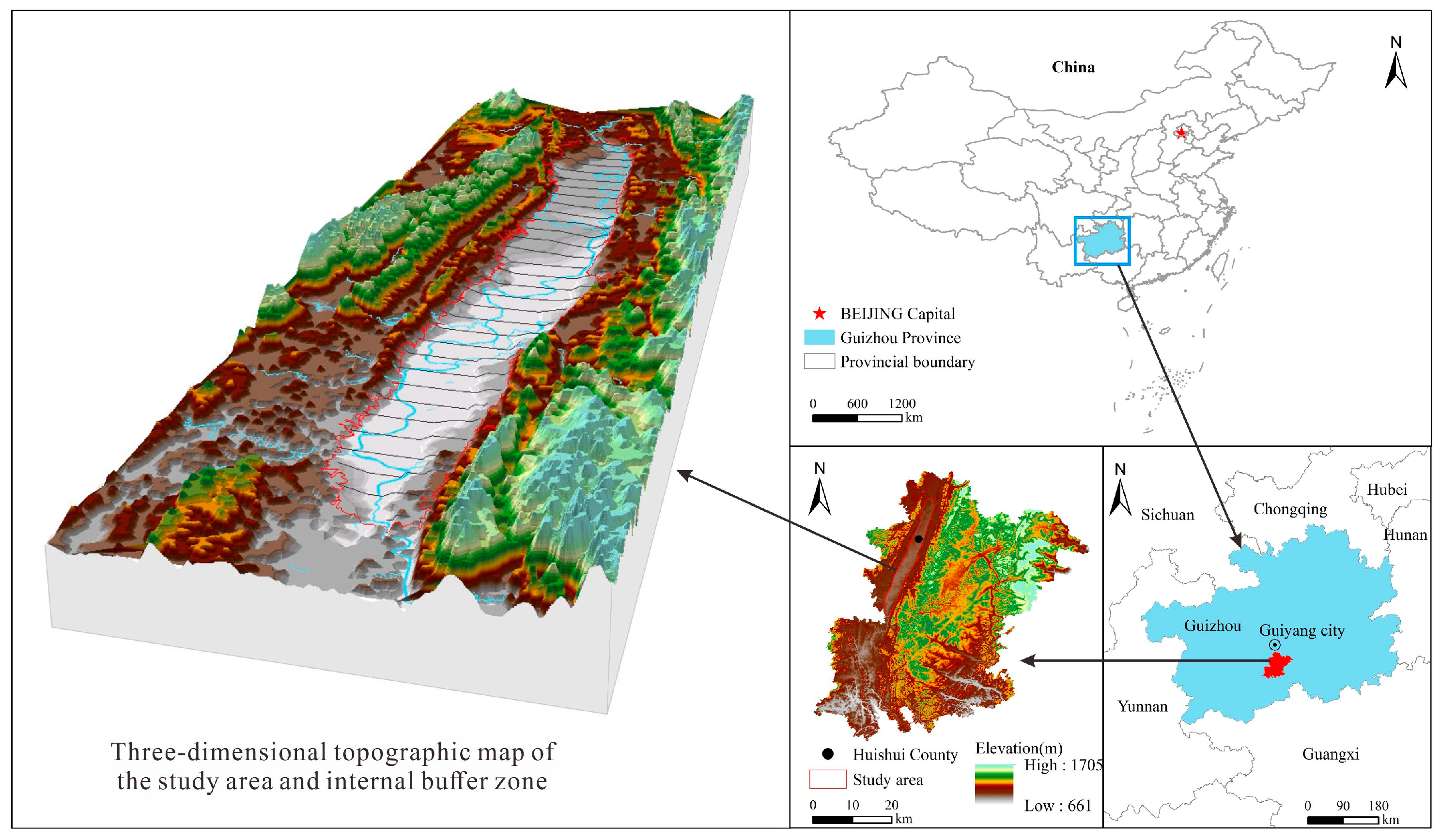
2. Study Area
3. Research Methods
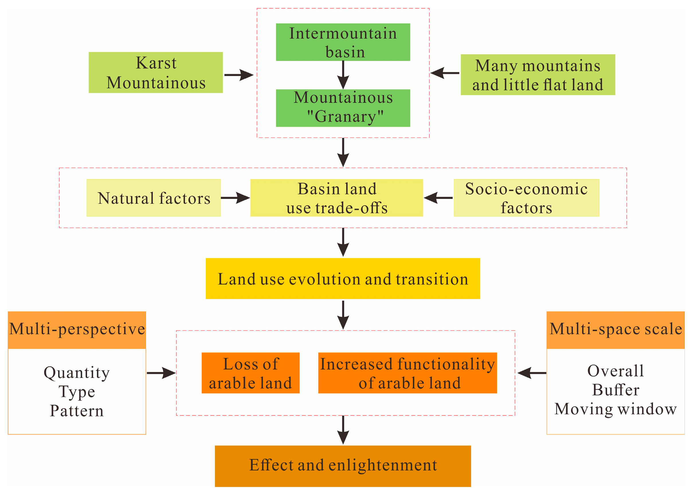
3.1. Research Ideas
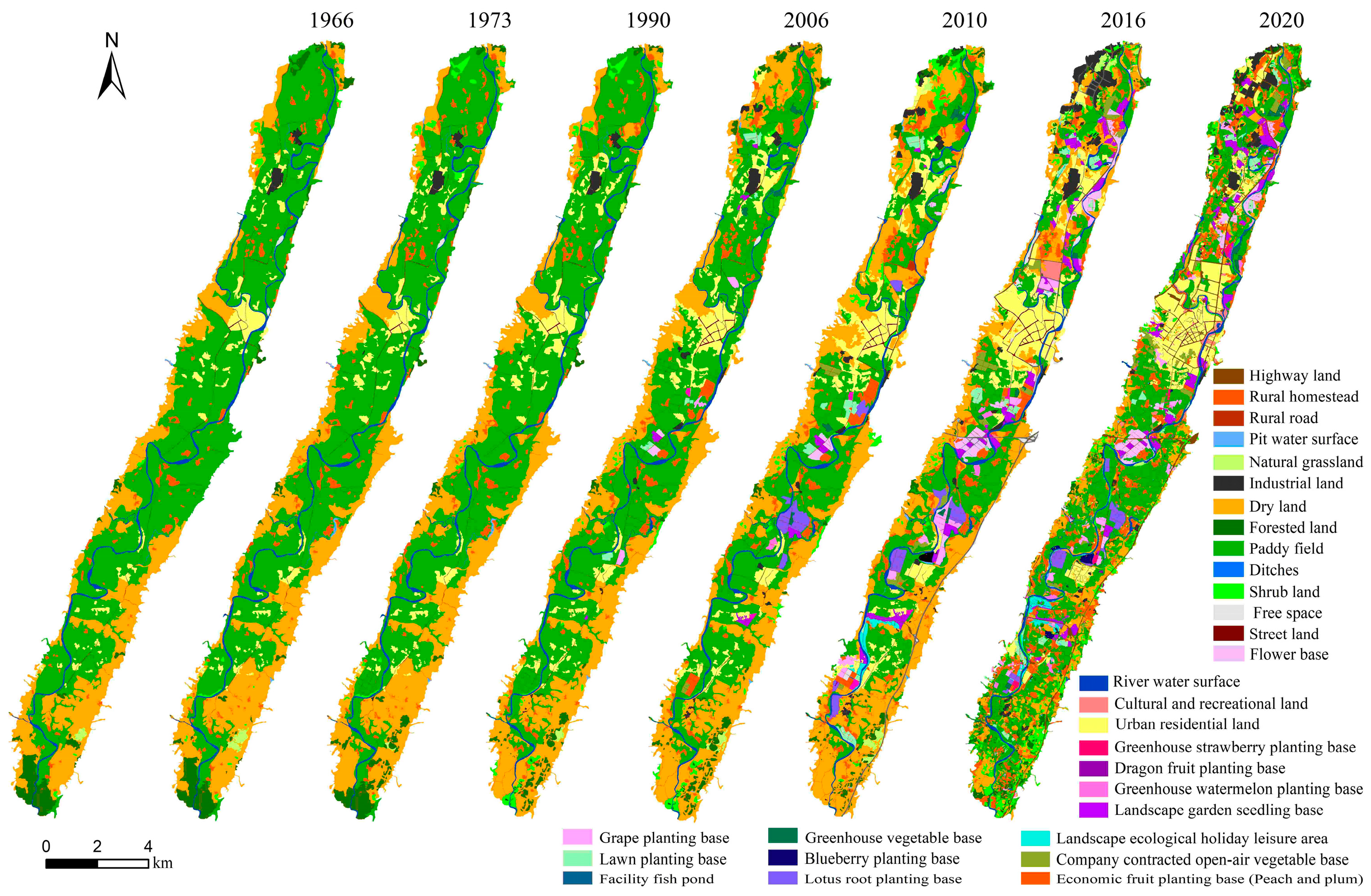
3.2. Data Sources and Land-use Classifications
3.3. Research Scales and Calculation of Indicators
3.3.1. Landscape Pattern Index
3.3.2. Overall Scale
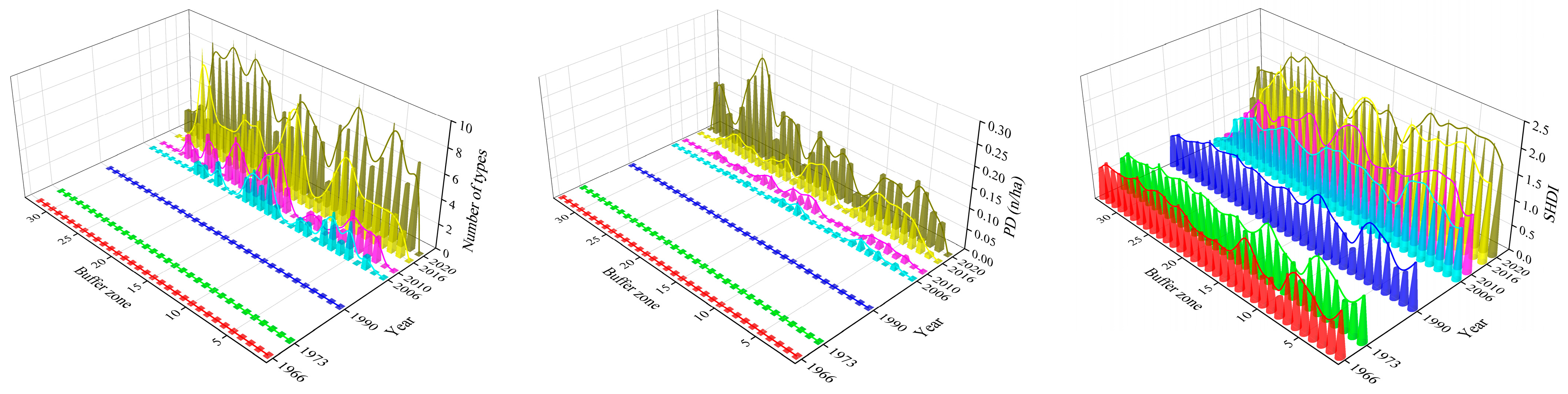
3.3.3. Buffer Scale
3.3.4. Moving Window Scale
4. Results Analysis
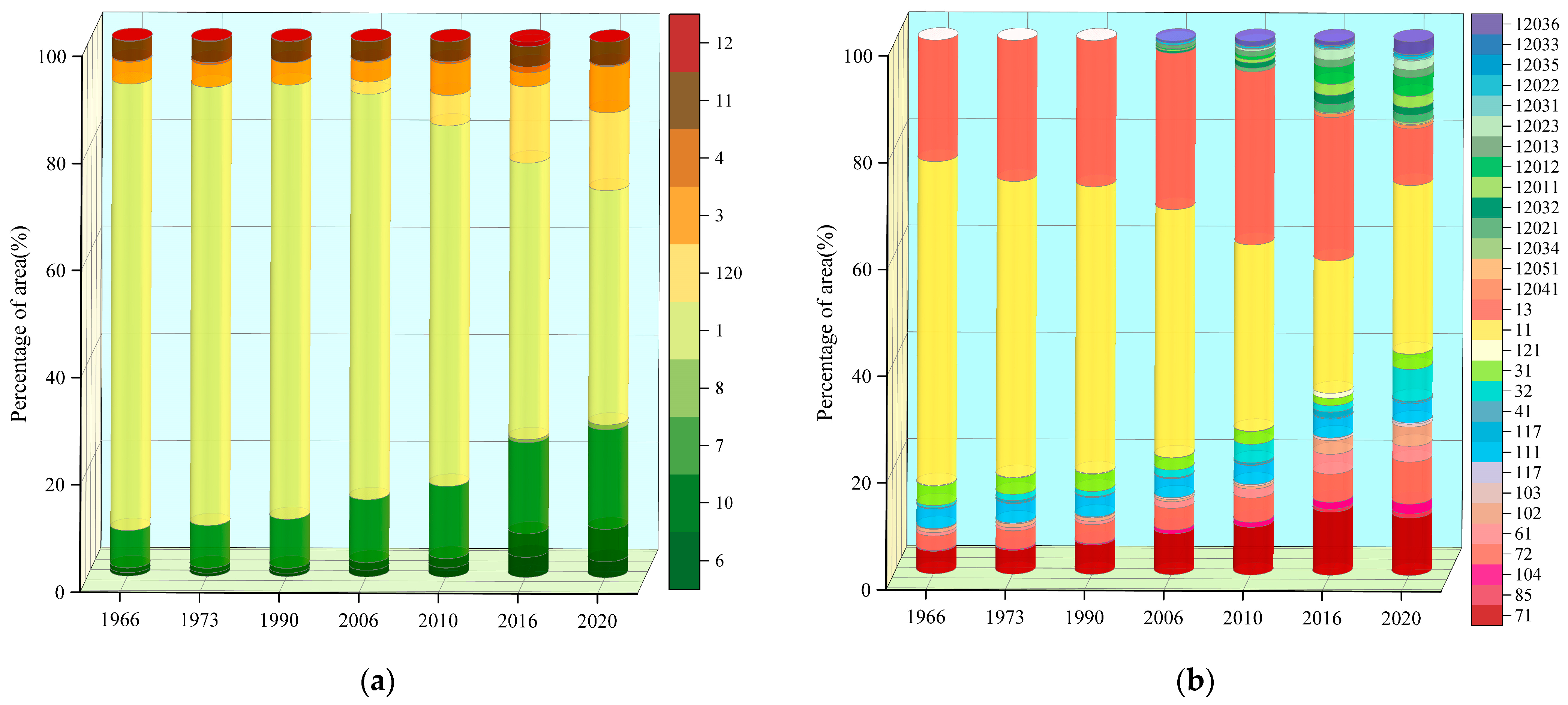
4.1. Quantity Transition Characteristics of Land-use
4.1.1. Quantity Transition Characteristics of Land-use for the Overall Basin
4.1.2. Quantity Transition Characteristics of Land-use in Different Basin Buffer Zones
4.2. Transition Characteristics of Land-use Type
4.2.1. Type Transition Characteristics of Land-use for the Overall Basin
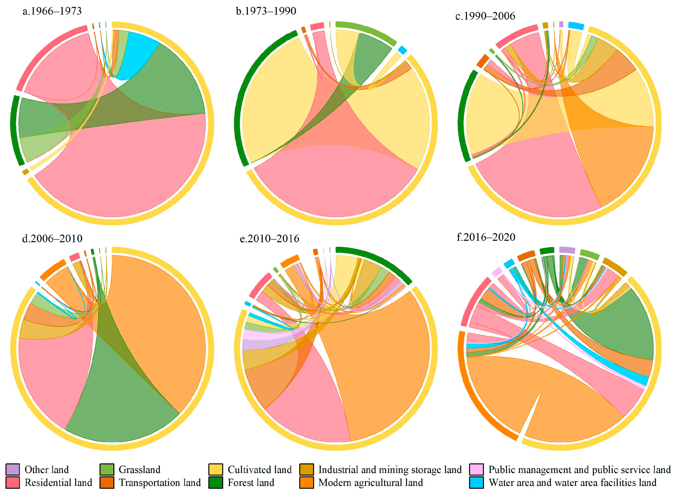
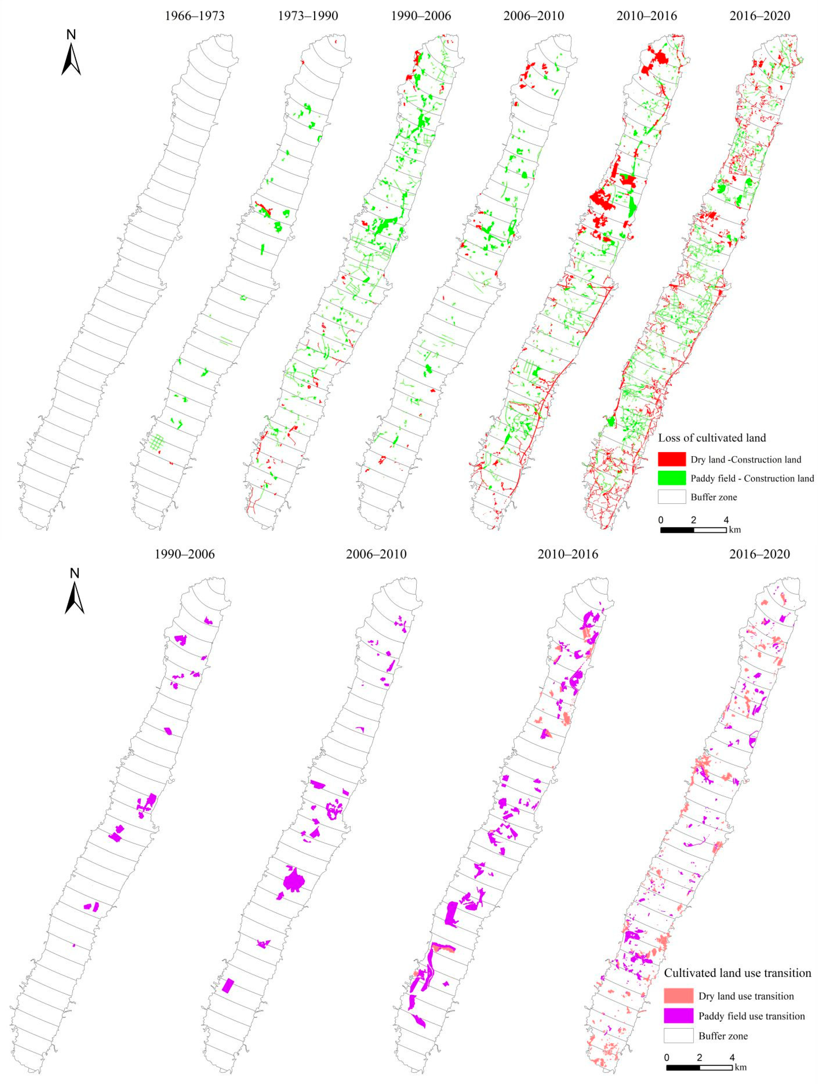
4.2.2. Type Transition Characteristics of Land-use in Different Basin Buffer Zones
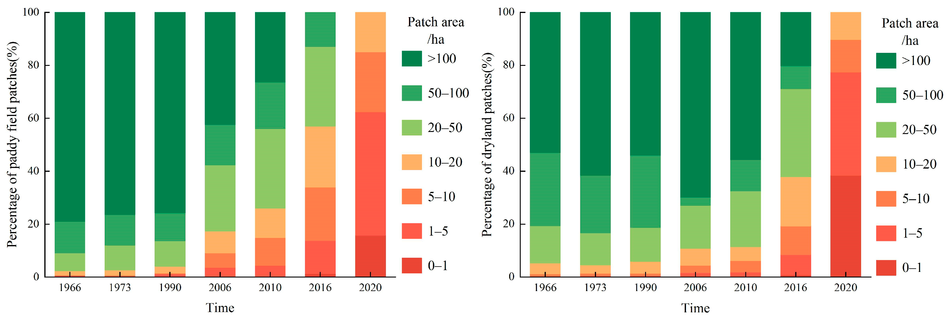
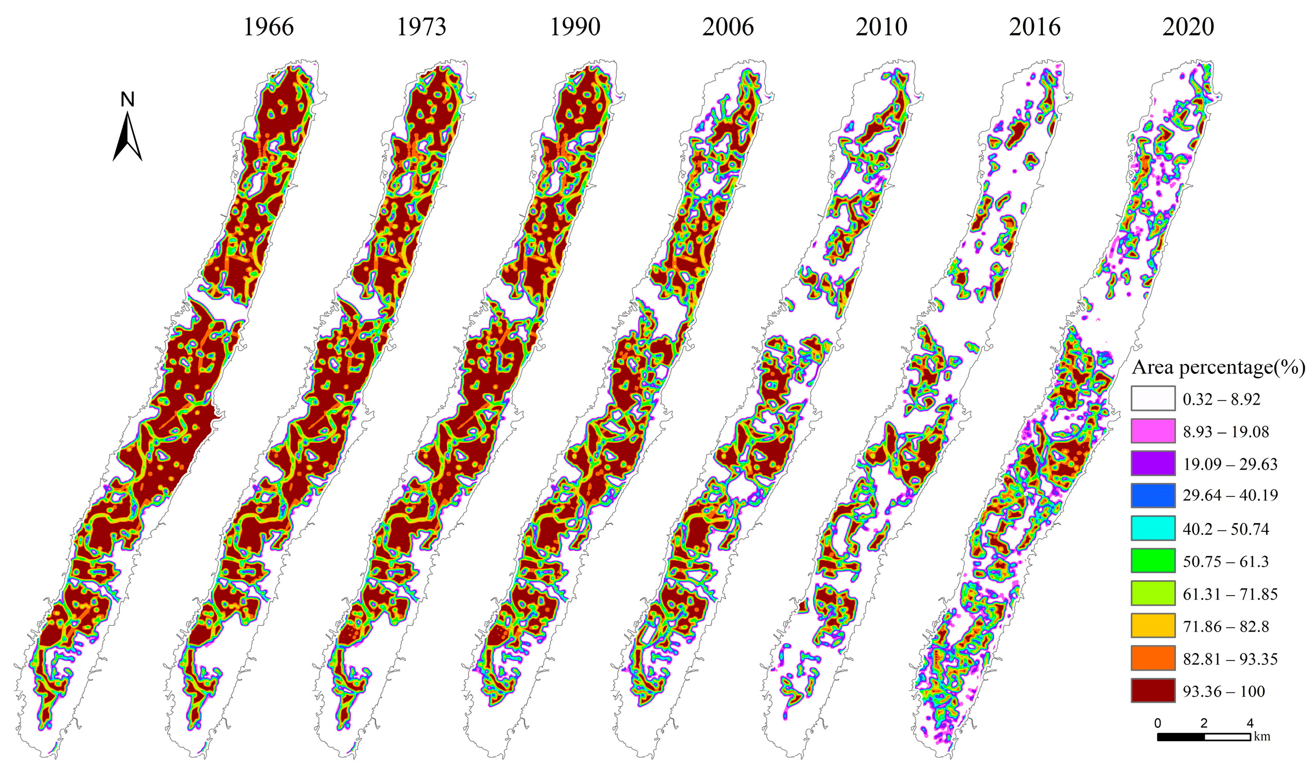
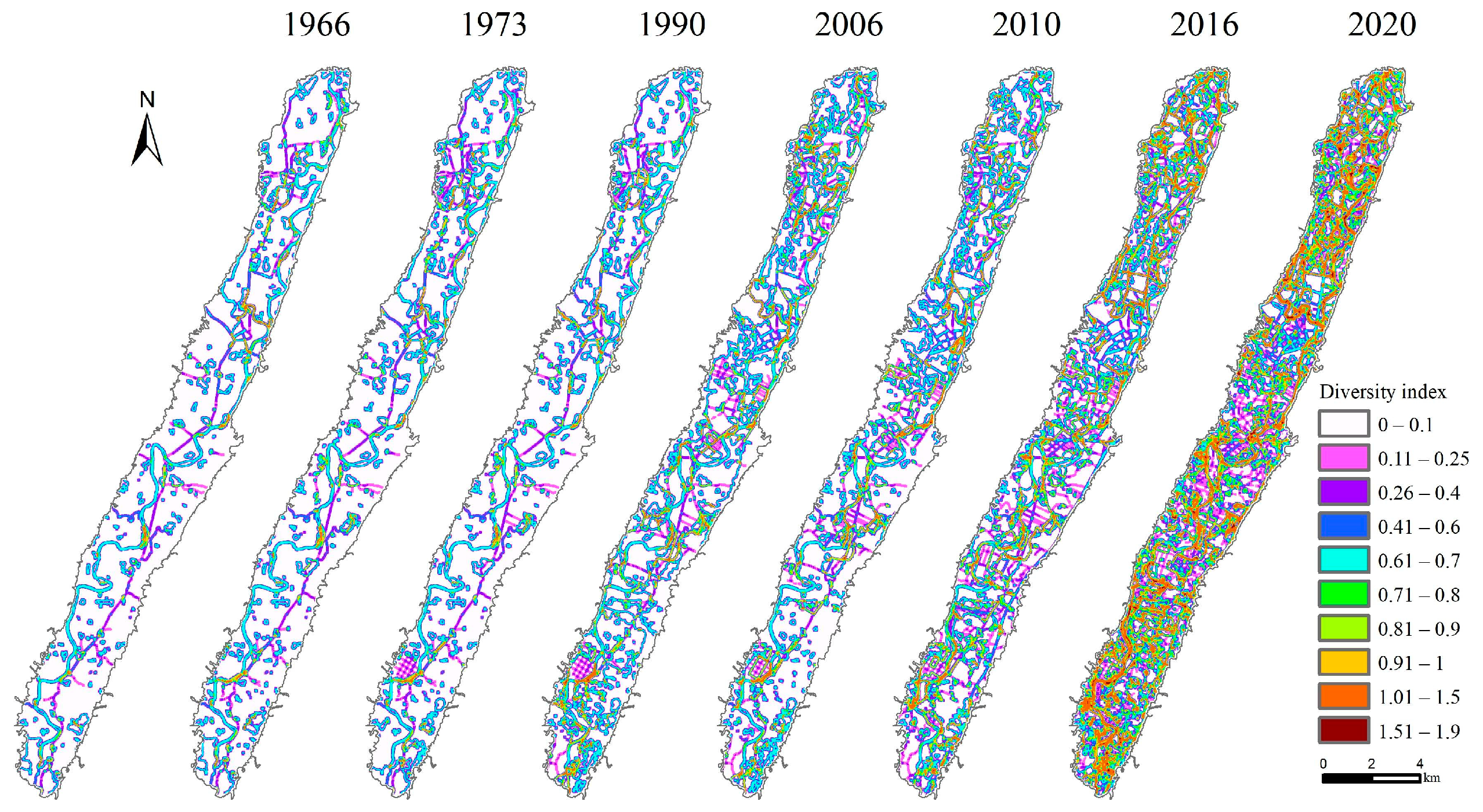
4.3. Landscape Pattern Transition Characteristics of Land-use
4.3.1. Landscape Transition Characteristics of Land-use for the Overall Basin
4.3.2. Landscape Transition Characteristics of Land-use in Different Basin Buffer Zones
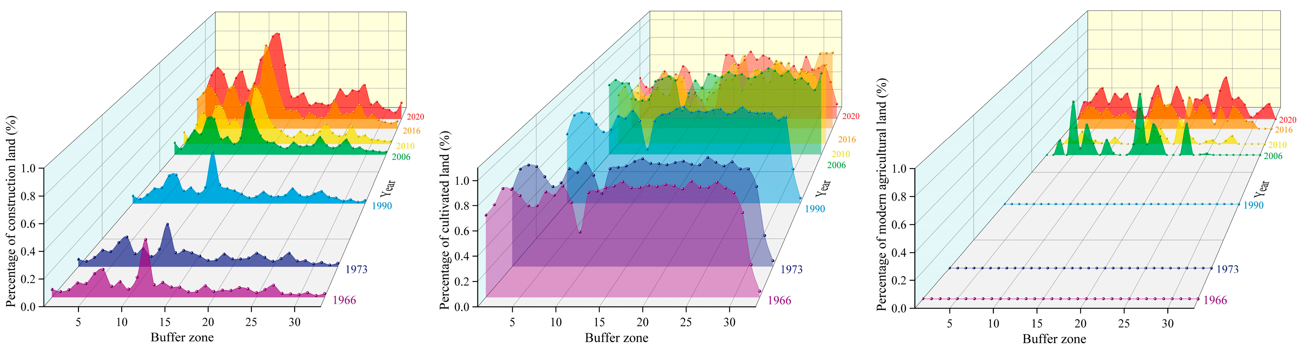
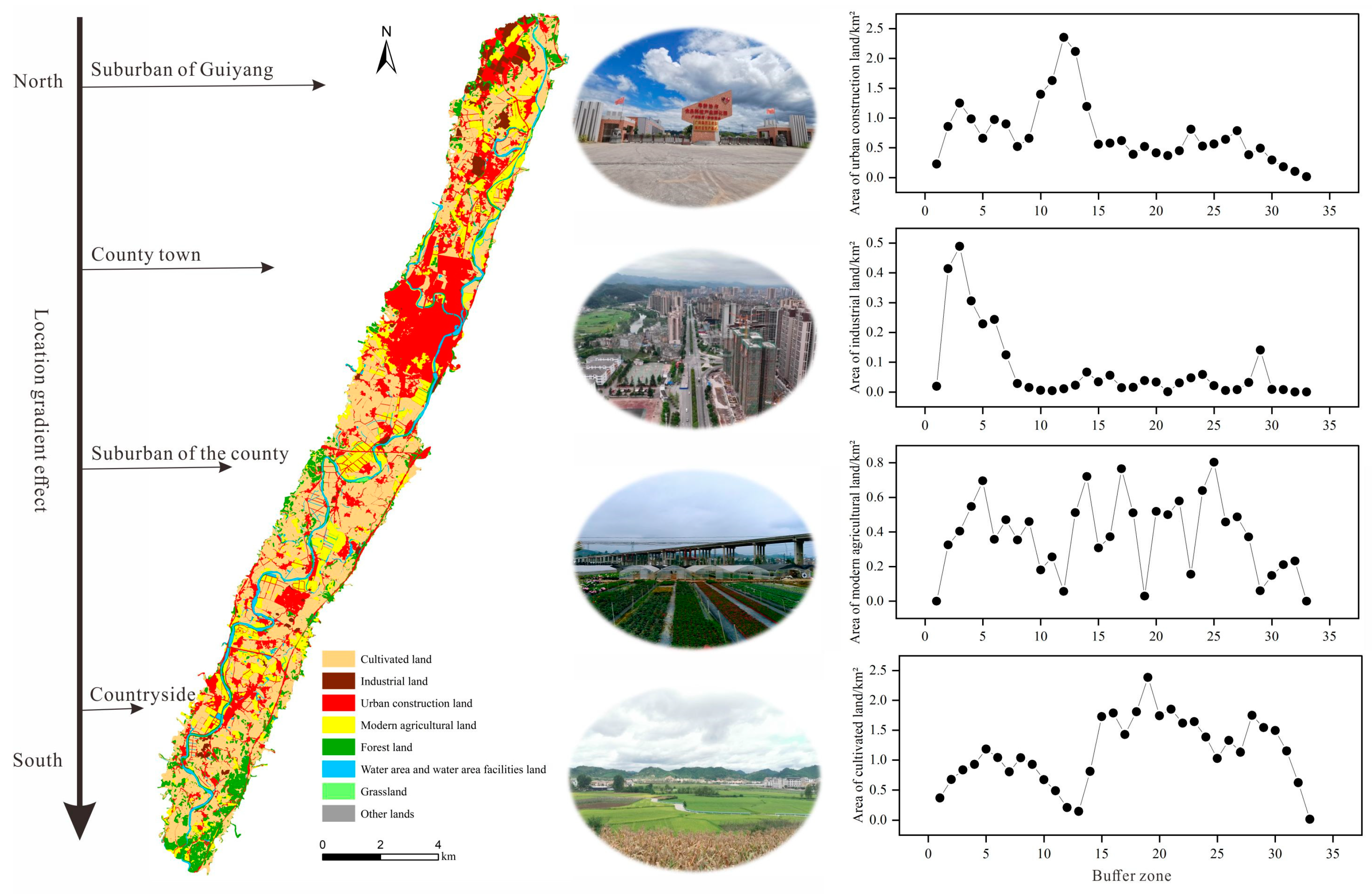
4.4. Gradient Effects of Land-use Transition in the Basin
5. Discussion
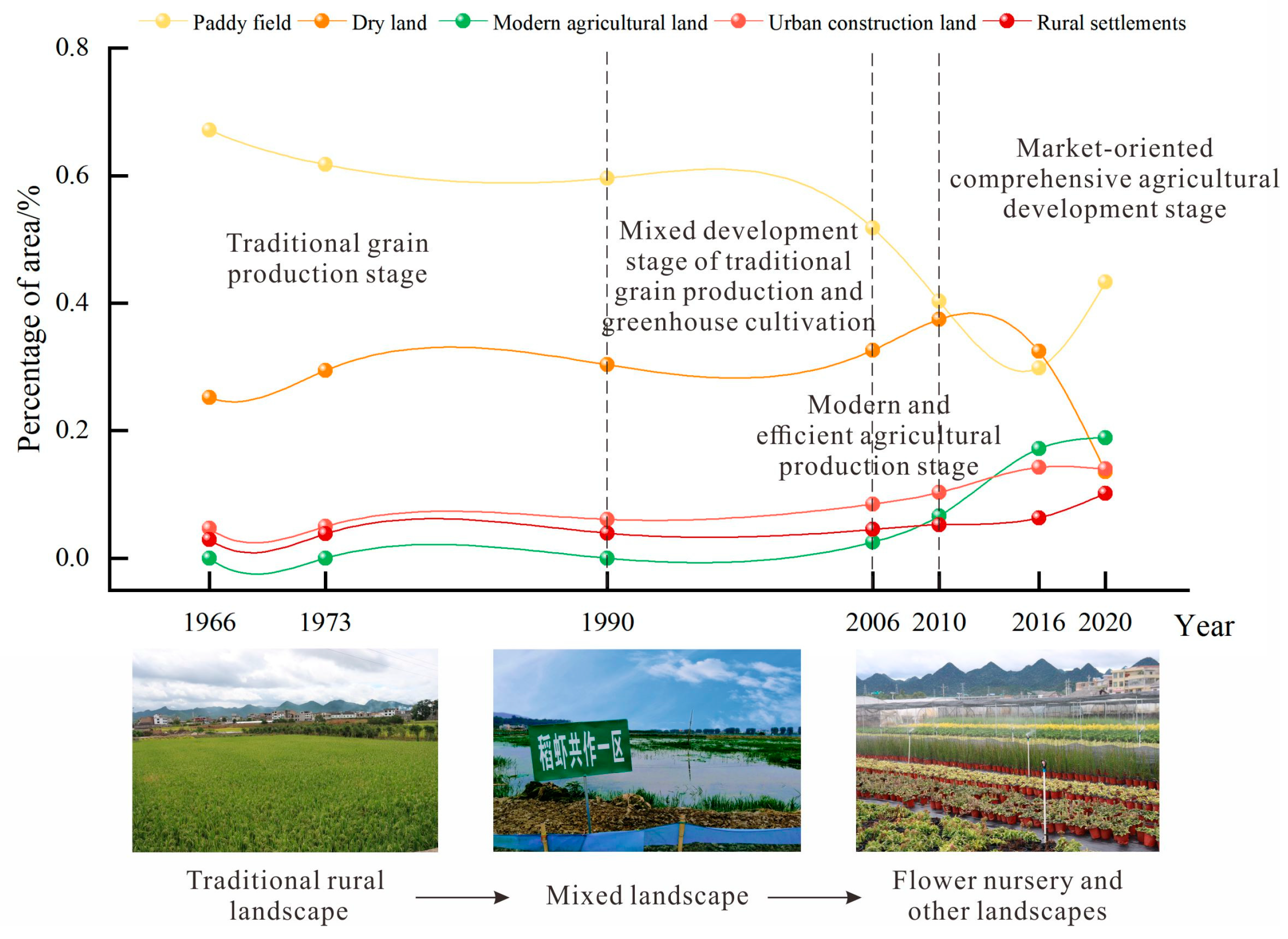
5.1. Theoretical Model of Evolution and Transformation of Land-use in Rural Basins in Karst Mountainous Areas
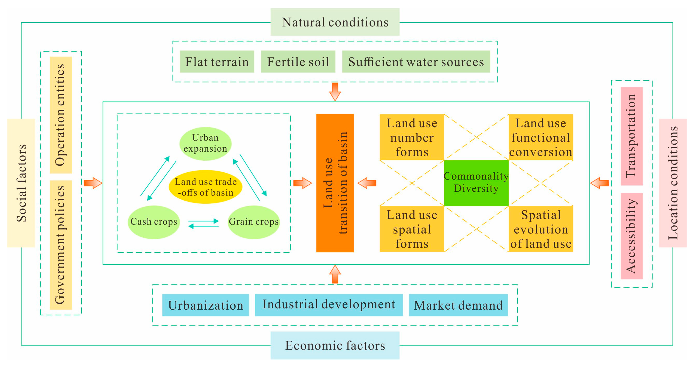
5.2. Driving Mechanism of Land-use Transition in the Basin
5.3. Effect and Enlightenment of Land-use Transition in the Basin
6. Conclusions
Author Contributions
Funding
Data Availability Statement
Conflicts of Interest
References
- Foley, J.A.; DeFries, R.; Asner, G.P.; Barford, C.; Bonan, G.; Carpenter, S.R.; Chapin, F.S.; Coe, M.T.; Daily, G.C.; Gibbs, H.K.; et al. Global Consequences of Land Use. Science 2005, 309, 570–574. [Google Scholar] [CrossRef] [PubMed]
- Defries, R.S.; Foley, J.A.; Asner, G.P. Land-Use Choices: Balancing Human Needs and Ecosystem Function. Front. Ecol. Environ. 2004, 2, 249. [Google Scholar] [CrossRef]
- Li, H.; Song, W. Spatial transformation of changes in global cultivated land. Sci. Total Environ. 2023, 859, 160194. [Google Scholar] [CrossRef] [PubMed]
- Lepers, E.; Lambin, E.F.; Janetos, A.C.; Defries, R.; Achard, F.; Ramankutty, N.; Scholes, R.J. A Synthesis of Rapid Land-Cover Change Information for the 1981-2000 period. Bioscience 2005, 55, 115–124. [Google Scholar] [CrossRef]
- Turner, B.L., 2nd; Lambin, E.F.; Reenberg, A. The emergence of land change science for global environmental change and sustainability. Proc. Natl. Acad. Sci. USA 2007, 104, 20666–20671. [Google Scholar] [CrossRef] [PubMed]
- Long, H.; Heilig, G.K.; Li, X.; Zhang, M. Socio-economic development and land-use change: Analysis of rural housing land transition in the Transect of the Yangtse River, China. Land Use Pol. 2007, 24, 141–153. [Google Scholar] [CrossRef]
- Long, H.; Qu, Y.; Tu, S.; Zhang, Y.; Jiang, Y. Development of land use transitions research in China. J. Geogr. Sci. 2020, 30, 1195–1214. [Google Scholar] [CrossRef]
- Song, X. Discussion on land use transition research framework. Acta Geogr. Sin. 2017, 72, 471–487. (In Chinese) [Google Scholar]
- Xiang, J.; Song, X.; Li, J. Cropland Use Transitions and Their Driving Factors in Poverty-Stricken Counties of Western Hubei Province, China. Sustainability 2019, 11, 1997. [Google Scholar] [CrossRef]
- Chen, R.; Ye, C.; Cai, Y.; Xing, X.; Chen, Q. The impact of rural out-migration on land use transition in China: Past, present and trend. Land Use Pol. 2014, 40, 101–110. [Google Scholar] [CrossRef]
- Xia, C.; Li, Y.; Shao, J.; Yan, S.; Chen, Y.; Zheng, L.; Wang, R. The coupling effect of socio-economic and eco-environment and land use transformation in mountainous areas—A case of the Fengjie County in the Three Gorges Reservoir Area, China. Environ. Sci. Pollut. Res. Int. 2023, 30, 38409–38424. [Google Scholar] [CrossRef] [PubMed]
- Long, H.; Qu, Y.; Tu, S.; Li, Y.; Ge, D.; Zhang, Y.; Ma, L.; Wang, W.; Wang, J. Land use transitions under urbanization and their environmental effects in the farming areas of China: Research progress and prospect. Adv. Earth Sci. 2018, 33, 455–463. (In Chinese) [Google Scholar]
- Zuo, Q.; Zhou, Y.; Wang, L.; Li, Q.; Liu, J. Impacts of future land use changes on land use conflicts based on multiple scenarios in the central mountain region, China. Ecol. Indic. 2022, 137, 108743. [Google Scholar] [CrossRef]
- Tuan, Y. Geography, Phenomenology, And The Study Of Human Nature. Can. Geogr./Le Géographe Can. 1971, 15, 181–192. [Google Scholar] [CrossRef]
- Liang, X.; Jin, X.; Ren, J.; Gu, Z.; Zhou, Y. A research framework of land use transition in Suzhou City coupled with land use structure and landscape multifunctionality. Sci. Total Environ. 2020, 737, 139932. [Google Scholar] [CrossRef] [PubMed]
- Liu, J.; Kuang, W.; Zhang, Z.; Xu, X.; Qin, Y.; Ning, J.; Zhou, W.; Zhang, S.; Li, R.; Yan, C.; et al. Spatiotemporal characteristics, patterns, and causes of land-use changes in China since the late 1980s. J. Geogr. Sci. 2014, 24, 195–210. [Google Scholar] [CrossRef]
- Ning, J.; Liu, J.; Kuang, W.; Xu, X.; Zhang, S.; Yan, C.; Li, R.; Wu, S.; Hu, Y.; Du, G.; et al. Spatiotemporal patterns and characteristics of land-use change in China during 2010–2015. J. Geogr. Sci. 2018, 28, 547–562. [Google Scholar] [CrossRef]
- Song, X.; Huang, Y.; Wu, Z.; Ouyang, Z. Does cultivated land function transition occur in China? J. Geogr. Sci. 2015, 25, 817–835. [Google Scholar] [CrossRef]
- Song, X.; Li, X. Theoretical explanation and case study of regional cultivated land use function transition. Acta Geogr. Sin. 2019, 74, 992–1010. (In Chinese) [Google Scholar]
- Zhang, B.L.; Sun, P.L.; Jiang, G.H.; Zhang, R.J.; Gao, J.B. Rural land use transition of mountainous areas and policy implications for land consolidation in China. J. Geogr. Sci. 2019, 29, 1713–1730. [Google Scholar] [CrossRef]
- Zhang, Z.; Zinda, J.A.; Li, W. Forest transitions in Chinese villages: Explaining community-level variation under the returning forest to farmland program. Land Use Pol. 2017, 64, 245–257. [Google Scholar] [CrossRef]
- Liang, X.; Jin, X.; Yang, X.; Xu, W.; Lin, J.; Zhou, Y. Exploring cultivated land evolution in mountainous areas of Southwest China, an empirical study of developments since the 1980s. Land Degrad. Dev. 2021, 32, 546–558. [Google Scholar] [CrossRef]
- Shifaw, E.; Sha, J.M.; Li, X.M.; Bao, Z.C.; Legass, A.; Belete, M.; Ji, J.W.; Su, Y.C.; Addis, A.K. Farmland dynamics in Pingtan, China: Understanding its transition, landscape structure and driving factors. Environ. Earth. Sci. 2019, 78, 535. [Google Scholar] [CrossRef]
- Long, H.; Ge, D.; Zhang, Y.; Tu, S.; Qu, Y.; Ma, L. Changing man-land interrelations in China’s farming area under urbanization and its implications for food security. J. Environ. Manag. 2018, 209, 440–451. [Google Scholar] [CrossRef] [PubMed]
- Zhang, L.; Wang, Z.; E, S.; Du, G.; Chen, Z. Analysis of Climatic Basis for the Change of Cultivated Land Area in Sanjiang Plain of China. Front. Earth Sci. 2022, 10, 862141. [Google Scholar] [CrossRef]
- Feng, Z.; Yang, Y.; You, Z. Research on land resources restriction on population distribution in China, 2000–2010. Geogr. Res. 2014, 33, 1395–1405. (In Chinese) [Google Scholar]
- Li, Y.; Rao, P.; Luo, G.; Qiu, C. The Land Use Evolution and Arable Land Protection of the Basin Land System in Guizhou Province; China Sicence Publishing & Media Ltd.: Beijing, China, 2015; Volume 1. (In Chinese) [Google Scholar]
- Li, Y.; Yao, Y.; Xie, J.; Wang, F.; Bai, X. Spatial-temporal evolution of land use and landscape pattern of the mountainbasin system in Guizhou Province. Acta Ecol. Sin. 2014, 34, 3257–3265. (In Chinese) [Google Scholar]
- Zhang, H.; Li, Y.B.; Xu, Q.; Yu, M.; Huang, J. Land Use Transition of the Mountain-Basin System under the Background of Rural Revitalization: Based on Four Typical Mountain-Basin Systems. Pol. J. Environ. Stud. 2022, 31, 3429–3445. [Google Scholar] [CrossRef]
- Chen, H.; Li, Y.; Sheng, J. Study on the evolution of land use function of basins based on land use change in Guizhou province, China. Acta Ecol. Sin. 2019, 39, 9325–9338. (In Chinese) [Google Scholar] [CrossRef]
- Chen, M.; Li, Y.; Tang, F.; Xu, Q.; Yu, M.; Zhang, H.; Li, X. Transformation of Paddy Field Use in Intermountain-Type Basins Using Evidence from the Structure and Function Perspective of Karst Mountain Areas in Southwest China. Agronomy 2023, 13, 1552. [Google Scholar] [CrossRef]
- Wang, C.Y.; Wu, D.N.; Shen, Z.H.; Peng, M.C.; Ou, X.K. How do physical and social factors affect urban landscape patterns in intermountain basins in Southwest China? Landsc. Ecol. 2021, 36, 1893–1911. [Google Scholar] [CrossRef]
- Shi, S.; LiI, X.; Hu, B. Theory and Research Prospect of Multi-function in Karst Region. Econ. Geogr. 2022, 42, 74–83. (In Chinese) [Google Scholar]
- Lv, L.; Han, X.; Long, H.; Zhou, B.; Zang, Y.; Wang, J.; Fan, Y. Research progress and prospects on supply and demand matching of farmland multifunctions. Resour. Sci. 2023, 45, 1351–1365. (In Chinese) [Google Scholar] [CrossRef]
- Liang, X.; Li, Y. Spatiotemporal features of farmland scaling and the mechanisms that underlie these changes within the Three Gorges Reservoir Area. J. Geogr. Sci. 2019, 29, 18. [Google Scholar] [CrossRef]
- Latifovic, R.; Olthof, I. Accuracy assessment using sub-pixel fractional error matrices of global land cover products derived from satellite data. Remote Sens. Environ. 2004, 90, 153–165. [Google Scholar] [CrossRef]
- GB/T21010-2017; Ministry of Land Resources. Current Land Use Classification. Standards Press of China: Beijing, China, 2017. (In Chinese)
- Riitters, K.H.; O’Neill, R.V.; Hunsaker, C.T.; Wickham, J.D.; Yankee, D.H.; Timmins, S.P.; Jones, K.B.; Jackson, B.L. A factor analysis of landscape pattern and structure metrics. Landsc. Ecol. 1995, 10, 23–39. [Google Scholar] [CrossRef]
- Wei, X.; Xiao, Z.; Li, Q.; Li, P.; Xiang, C. Evaluating the effectiveness of landscape configuration metrics from landscape composition metrics. Landsc. Ecol. Eng. 2017, 13, 169–181. [Google Scholar] [CrossRef]
- Yan, J.; Xiao, R.; Su, F.; Bai, J.; Jia, F. Impact of Port Construction on the Spatial Pattern of Land Use in Coastal Zones Based on CLDI and LUT Models: A Case Study of Qingdao and Yantai. Remote Sens. 2021, 13, 3110. [Google Scholar] [CrossRef]
- Baker, W.L.; Cai, Y. The r.le programs for multiscale analysis of landscape structure using the GRASS geographical information system. Landsc. Ecol. 1992, 7, 291–302. [Google Scholar] [CrossRef]
- Long, H.; Li, T. The coupling characteristics and mechanism of farmland and rural housing land transition in China. J. Geogr. Sci. 2012, 22, 548–562. [Google Scholar] [CrossRef]
- Lyu, X.; Peng, W.; Niu, S.; Qu, Y.; Xin, Z. Evaluation of sustainable intensification of cultivated land use according to farming households’ livelihood types. Ecol. Indic. 2022, 138, 108848. [Google Scholar] [CrossRef]
- Gomes, E.; Banos, A.; Abrantes, P.; Rocha, J.; Kristensen, S.B.P.; Busck, A. Agricultural land fragmentation analysis in a peri-urban context: From the past into the future. Ecol. Indic. 2019, 97, 380–388. [Google Scholar] [CrossRef]
- Long, H. Land Use Transition and Rural Transformation Development. Prog. Geogr. 2012, 31, 131–138. (In Chinese) [Google Scholar]
- Li, J.; Feng, S.; Luo, T.; Guan, Z. What drives the adoption of sustainable production technology? Evidence from the large scale farming sector in East China. J. Clean. Prod. 2020, 257, 120611. [Google Scholar] [CrossRef]
- Yu, L.; Li, Y.; Luo, G.; Ge, G.; Zhang, H.; Tang, F.; Yu, M. Spatiotemporal evolution and driving mechanism of slope cultivated land in karst mountainous areas of Southwest China—A case study of Puding County, Guizhou Province. Land Degrad. Dev. 2023, 1–18. [Google Scholar] [CrossRef]
- Yang, Q.; Zhang, D. The influence of agricultural industrial policy on non-grain production of cultivated land: A case study of the “one village, one product” strategy implemented in Guanzhong Plain of China. Land Use Pol. 2021, 108, 105579. [Google Scholar] [CrossRef]
- Su, Y.; Qian, K.; Lin, L.; Wang, K.; Guan, T.; Gan, M. Identifying the driving forces of non-grain production expansion in rural China and its implications for policies on cultivated land protection. Land Use Pol. 2020, 92, 104435. [Google Scholar] [CrossRef]
- Liu, Y.; Long, H. Land use transitions and their dynamic mechanism: The case of the Huang-Huai-Hai Plain. J. Geogr. Sci. 2016, 26, 515–530. [Google Scholar] [CrossRef]
- Wang, Z.; Ye, H.; Zhang, L. Understanding the characteristics and mechanism of land use transition in mountainous economic zone: A case study of the Chengdu-Chongqing region in southwestern China. Front. Environ. Sci. 2022, 10, 963197. [Google Scholar] [CrossRef]
- Zhang, Y.; Long, H.; Ma, L.; Qu, Y. Farmland function evolution in the Huang-Huai-Hai Plain: Processes, patterns and mechanisms. J. Geogr. Sci. 2018, 28, 759–777. [Google Scholar] [CrossRef]
- Zhang, S.; Deng, W.; Peng, L.; Zhou, P.; Liu, Y. Has Rural Migration Weakened Agricultural Cultivation? Evidence from the Mountains of Southwest China. Agriculture 2020, 10, 63. [Google Scholar] [CrossRef]
- Vanbergen, A.J.; Aizen, M.A.; Cordeau, S.; Garibaldi, L.A.; Garratt, M.P.D.; Kovács-Hostyánszki, A.; Lecuyer, L.; Ngo, H.T.; Potts, S.G.; Settele, J.; et al. Chapter Six—Transformation of agricultural landscapes in the Anthropocene: Nature’s contributions to people, agriculture and food security. In Advances in Ecological Research; Bohan, D.A., Vanbergen, A.J., Eds.; Academic Press: Cambridge, MA, USA, 2020; Volume 63, pp. 193–253. [Google Scholar]
- Tang, Y.; Lu, X.; Yi, J.; Wang, H.; Zhang, X.; Zheng, W. Evaluating the spatial spillover effect of farmland use transition on grain production—An empirical study in Hubei Province, China. Ecol. Indic. 2021, 125, 107478. [Google Scholar] [CrossRef]
- Botticini, F.; Auzins, A.; Lacoere, P.; Lewis, O.; Tiboni, M. Land Take and Value Capture: Towards More Efficient Land Use. Sustainability 2022, 14, 778. [Google Scholar] [CrossRef]
- Yin, G.; Liu, L.; Jiang, X. The sustainable arable land use pattern under the tradeoff of agricultural production, economic development, and ecological protection—An analysis of Dongting Lake basin, China. Environ. Sci. Pollut. Res. Int. 2017, 24, 25329–25345. [Google Scholar] [CrossRef] [PubMed]
- Long, H.; Qu, Y. Land use transitions and land management: A mutual feedback perspective. Land Use Pol. 2018, 74, 111–120. [Google Scholar] [CrossRef]
- Yang, L.; Tian, G.; Li, L.; Duan, J. The transition characteristics and driving mechanisms of rural residential land in metropolitan areas—A case study of Tianjin, China. Environ. Sci. Pollut. Res. Int. 2023, 30, 54130–54148. [Google Scholar] [CrossRef]
- Long, H.; Zhang, Y.; Tu, S. Rural vitalization in China: A perspective of land consolidation. J. Geogr. Sci. 2019, 29, 517–530. [Google Scholar] [CrossRef]
- Qin, L.; Bai, X.; Wang, S.; Zhou, D.; Chen, W.; Luo, G.; Zhang, S.; Cui, Z. History of Land Use Change and Driving Mechanism of Typical Guizhou Plateau Region During 40 Years. Mt. Res. 2015, 33, 619–628. (In Chinese) [Google Scholar] [CrossRef]
- Liu, Y.; Zhou, Y. Reflections on China’s food security and land use policy under rapid urbanization. Land Use Pol. 2021, 109, 105699. [Google Scholar] [CrossRef]
- Chen, L.; Zhao, H.; Song, G.; Liu, Y. Optimization of cultivated land pattern for achieving cultivated land system security: A case study in Heilongjiang Province, China. Land Use Pol. 2021, 108, 105589. [Google Scholar] [CrossRef]
- El Bilali, H.; Callenius, C.; Strassner, C.; Probst, L. Food and nutrition security and sustainability transitions in food systems. Food Energy Secur. 2019, 8, e00154. [Google Scholar] [CrossRef]
- Xu, W.; Jin, X.; Liu, J.; Li, H.; Zhang, X.; Zhou, Y. Spatiotemporal evolution and the detection of key drivers in the resilience of cultivated land system in major grain-producing regions of China. Land Degrad. Dev. 2023, 34, 4712–4727. [Google Scholar] [CrossRef]


| Time | Image Types | Waveband | Wavelength | Resolution | Local Features | Land-use Features |
|---|---|---|---|---|---|---|
| 1966 | Panchromatic image of American keyhole satellite | panchromatic | 2.7 m |  | Mainly paddy field use | |
| 1973 | 1:50,000 topographic map | 2.7 m |  | Mainly paddy field use | ||
| 1990 | SPOT2 image | panchromatic | 0.50–0.73 μm | 10 m |  | Mainly paddy field use |
| 2006 | SPOT5 image | panchromatic super-mode | 0.48–0.71 μm | 2.5 m |  | Mainly paddy field use |
| 2010 | ALOS image | Band 1–3 | 1:0.42–0.50 μm 2:0.52–0.60 μm 3:0.61–0.69 μm | 2.5 m |  | Mainly modern agricultural land |
| 2016 | Google Earth image | Band 1–3 | 1:0.45–0.52 μm 2:0.52–0.60 μm 3:0.63–0.69 μm | 1.7 m |  | Mainly modern agricultural land |
| 2020 | GF-2 image | Band 1–3 | 1:0.45–0.52 μm 2:0.52–0.59 μm 3:0.63–0.69 μm | 3.24 m |  | Mainly modern agricultural land |
| Landscape Index | Ecological Meaning |
|---|---|
| TA/hm2 | Indicates the total area of a certain type of patch |
| PLAND/% | Indicates the percentage of landscape area that a given type of patch area represents per unit area of the study area |
| PD/n/hm2 | Indicates the number of patches of a certain patch type in the unit area of the study area, which can be used to reflect the fragmentation of the landscape; the larger the value, the more fragmented the landscape |
| SHDI | Indicates the diversity of landscape types; the richer the landscape elements, the higher the value of the index |
Disclaimer/Publisher’s Note: The statements, opinions and data contained in all publications are solely those of the individual author(s) and contributor(s) and not of MDPI and/or the editor(s). MDPI and/or the editor(s) disclaim responsibility for any injury to people or property resulting from any ideas, methods, instructions or products referred to in the content. |
© 2023 by the authors. Licensee MDPI, Basel, Switzerland. This article is an open access article distributed under the terms and conditions of the Creative Commons Attribution (CC BY) license (https://creativecommons.org/licenses/by/4.0/).
Share and Cite
Chen, M.; Li, Y.; Zhang, Y.; Yu, L.; Yang, L. Evolution and Transformation Analysis of Land-use in Mountainous “Granary”—Evidence from Typical Basin in Karst Mountainous Areas of Southwest China. Land 2024, 13, 4. https://doi.org/10.3390/land13010004
Chen M, Li Y, Zhang Y, Yu L, Yang L. Evolution and Transformation Analysis of Land-use in Mountainous “Granary”—Evidence from Typical Basin in Karst Mountainous Areas of Southwest China. Land. 2024; 13(1):4. https://doi.org/10.3390/land13010004
Chicago/Turabian StyleChen, Mei, Yangbing Li, Yiyi Zhang, Limin Yu, and Linyu Yang. 2024. "Evolution and Transformation Analysis of Land-use in Mountainous “Granary”—Evidence from Typical Basin in Karst Mountainous Areas of Southwest China" Land 13, no. 1: 4. https://doi.org/10.3390/land13010004