
Old, Lost, and Forgotten Rural Materialities: Old Local Irrigation Channels and Lost Local Walking Trails

IPP, CSIC, Spanish Council for Scientific Research, 28037 Madrid, Spain
Land 2022, 11(8), 1358; https://doi.org/10.3390/land11081358
Submission received: 19 July 2022
/
Revised: 15 August 2022
/
Accepted: 15 August 2022
/
Published: 20 August 2022
(This article belongs to the Special Issue New Methodological and Theoretical Approaches to Spatial Analysis in Landscape Dynamics)
Abstract
:Geo-historical studies have essentially focused on analyzing the historical evolution of the landscape and the processes of material resistance of rural landscapes against the dynamics of rural change. Historical landscapes are cumulative life micro-worlds. In the present contribution, the historical evolution of lost and disappeared rural roads and caceras—old local irrigation channels—is analyzed in a comparative way. The case studies were the Berbedillo river cacera system in the north of the province of Guadalajara and the Bustar path in the municipality of Bustarviejo in the province of Madrid. The methodology was based on a variety of research sources: written and archival documents, oral testimonies of the elderly, and micro-territorial recognition. The roads and caceras are lost but can continue to be represented, even if they can no longer be used for the life of rural communities. A new history of depopulation, restructuring, and loss is possible to (re)write based on spectral agrarian (im)materialities.
1. Introduction
To a large extent, historical geography has had rural areas and societies as its objects of study. Rural geo-historical studies have focused mainly on the historical evolution of the landscape and on the continuity and material resistance of rural landscapes to the dynamic processes of change in modern societies [1]. As Strohmayer [2] suggested, historical geography is an open field, an amalgamation of multiple geographic traditions. In this academic orientation, geography has a long tradition in the narrative explanation of landscape features, both in configuration as individual elements or as relational elements of a dynamic and complex whole.
In this context, research on rural roads and caceras—old local irrigations channels—can have multiple perspectives. It is possible to approach it from rural, cultural, or historical geography [3] (see also the literature quoted in this reference). The deconstruction of historical landscapes offers the possibility of analyzing local roads or caceras instead. From this conceptual point of view, rural roads and caceras are elements of historical landscapes that are formed on heterogeneous and multilayered bases.
In this contribution, we want to address a comparative analysis of lost and disappeared rural roads and caceras as an intersection of various geographical traditions, which serves as an interpretive framework of their complex evolution to the present. The case studies are the local irrigation system in the Berbedillo river valley in Bocigano, a small town in the north of the province of Guadalajara, and the Bustar path in the municipality of Bustarviejo in Madrid (Spain). In definition, the object of this paper is the analysis and discussion of the changing processes, dimensions, and visions of lost historical geographical materialities in the research context of a new re-materialization in rural geographical studies. In this sense, what is the original contribution of this paper? The contribution of this paper is situated in the lost materialities as possible ends of the process of rural restructuring.
Old, Lost, and Forgotten Materialities in (Rural) Geography. Water Paths and Paths of People and Animals
New geographical history allows associating and adapting various conceptual points of view in the analysis of old and lost landscape biographies [4] in the form of micro-spatial histories [5] of rural artifacts. These stories determine the continuity between past and present [6]. The genealogies of the landscape suggest a continuity of moral tensions [7]. With this perspective, it is possible to analyze the cultural meanings of historical survival in rural routes or other rural materialities and their spatial dimensions in history in different scales—from national to local This permanent duality between materiality and use or immateriality means that the paths of people or water never have a static character [8,9]. On the contrary, they have a fluid sense as a consequence of the complex association of material and everyday life ideas and dimensions [10] in the form of particular micro-environmental histories of hybrid landscapes, where the most material dimensions and non-representational geographies converge [11]. Historical landscapes are complex and cumulative life worlds with different phases: birth, growth, decline, and in some cases disappearance [12]. The life of historic trails is associated with both their representation and their use, a characteristic that may also be linked to the use of caceras [3].
Research on rural artifacts—objects that were made by people in the past for the management of the countryside—in the countryside can contribute to the analysis of the macro- and micro-dynamics of historical processes of rural change [13], as well as to determine in what way the past contributes and accommodates the complex processes of current rural transformation [14]. The study of old materialities is also useful for understanding the analytical complexity of rural processes [13]. The evolution of the historical rural materialities in a rural field system usually has three stages [11]: (1) The traditional stage is that in which a system of roads and paths is configured and expanded, with an agricultural dedication and a functional use from the space. The local dimension predominates in the management of the system of roads and paths, and conservation is carried out by the community. In geographic theory, this stage has been characterized as pastoralist, associated with an idealized, nostalgic, and romantic vision of the rural past [15]. (2) The modernist stage is where dedication is progressively toward forestry—organized or spontaneous—and traditional agricultural activities are abandoned. The system of paths and caceras falls into disuse and is forgotten but is preserved under the growth of undergrowth. The end of the traditional period, the afforestation—organized or spontaneous—of the area generates a rural landscape in the shade made up of paths, caceras, fences, sheepfolds, cabins, sheepfolds, etc. This stage has been linked in the geographical literature with the urban progress as a prism of modernity. Rural heritage gradually begins to acquire a relevant and emblematic role as a response to modernity [15]. (3) The postmodern stage is that in which an area begins to have a natural, cultural, and heritage value, and the multi-use of the space (agrarian) begins: recreational sports, cultural, forestry, and conservationist [16]. Decision making begins to be local, extra-local, or even national. When this recovery stage does not take place, the traditional paths or caceras remain in the shade. A few know about their existence, but they are impassable or unusable. The shadow conservation of rural artifacts in a cultural landscape is associated with non-use and non-knowledge. A nostalgic view of the community and traditional space through the material legacy of the disappeared local paths and caceras (re)emerges [17]. The abandonment of the rural environment suggests an aesthetic contemplation of the beautiful countryside [18]. The rural artifacts in the shadow are specific narratives that suggest old spatialities where the articulation between past, present, and future is broken. At this moment, a magical vision of the forgotten countryside appears. The ecological imagery is where space is a product of heterogeneous materialities [19].
In any case, the perception of the value of rural artifacts depends on each region and even each municipality [20], which influences their interpretation and recovery projects, but also their (dis)use. They have a particular value as material cultural heritage associated with their local socio-economic commodification, as well as intangible cultural heritage based on the fluid narratives of identity and the use of the past in the definitive composition of the present [21]. Dynamic communities act on open and close spaces in a continuous and fluid (re)articulation of micro-spaces. There is an adaptive relative value of local place in each time of history [22].
2. Methodology and Research Sources
All rural cultural landscapes have a unique local expression [10,23,24]. As Clark [13] suggested, the cultural turn in rural and historical geography benefits the biographical micro-scale level of study. The interpretation of the local community within the framework of a historical process of rural restructuring offers a singular vision of rural heritage conditioned by notable processes of abandonment of traditional land use and by the dynamics of transformation of the rural landscape and its social, cultural, and economic consequences. The interaction of territory (material base), heritage (cultural base), and community (social base) in the definition of a rural place makes it possible to generate adequate heritage management strategies [25]. In closed landscapes, the rural patrimonial elements of the territory acquire more relevance and generate more documentation, and their cartographic study and their location in field work are easier [26].
Research as a process: research difficulties. The common opposition between inhabited space and a rural environment usually generates a more detailed analysis of the living space. In contrast, in multiple studies, there has been a disinterest in buildings, roads, and multiple traditional artifacts located in the countryside. Research on old rural materialities requires a variety of sources, such as texts, policy documents, newspapers, reports, maps, diagrams, individual stories, photos, etc. For this reason, research on lost rural materialities is very complex and requires planning, both in the sequential use of information sources and the adequate and representative selection of case studies.
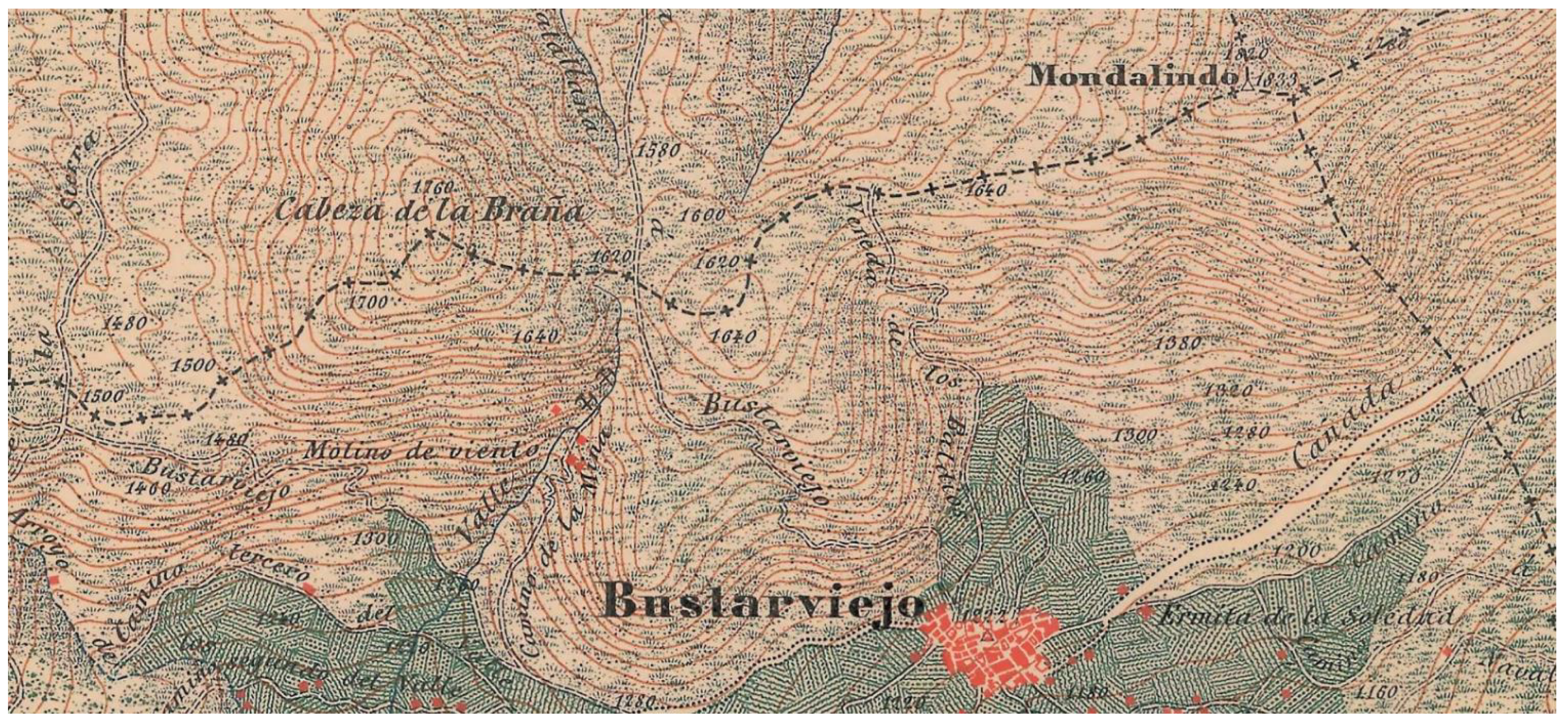
Study cases. Two case studies of lost materials were selected: (1) the old Bustar road in Bustarviejo, located in the municipality of Bustarviejo in the Mondalindo massif in the central system (Figure 1, Figure 2 and Figure 3), and (2) the Berbellido river cacera system, located in the Sierra de Ayllon (mountainous massif belonging to the central system located in the north of the province of Guadalajara), which rises at the foot of the Pico del Lobo massif at about 1930 m above sea level and runs in a north–south direction through the municipality of El Cardoso de la Sierra, crosses the town of Bocigano, and has a length of 12 km, ending at 1125 m high in the Jarama River (Figure 4, Figure 5 and Figure 6).
These are two cases of lost cultural landscapes located in mountain areas affected by processes of abandonment of traditional agricultural activities and multiple post-modern rural transitions. In both cases, the settlement and organization of the territory were articulated in medieval times [3], with the repopulation of the areas when the network of roads and the system of caceras for irrigation and water supply began to be generated, which were the main characteristics that articulated the rural space, persisting until the 1960s.
Study sources. There were three types of study sources: (1) Archived, written sources are characterized by their dispersion and fragmentation, in addition to the loss or deterioration of many local documents. Archival sources usually do not allow precise dating of the origin of the caceras or paths, but they contribute to geographically contextualizing the birth in relation to the historical process of organizing space [11]. The following documents were relevant: (a) the analysis of neighborhood conflicts or those between different municipalities and (b) the documentation of the Mesta—the historical organization of livestock in Spain between 1273 and 1836. (2) Oral sources of the elderly usually have problems of inaccuracy due to distance in time and the deterioration of memory but are also affected by the depopulation and low population of many rural villages [3]. (3) Territorial reconnaissance has two phases: (a) In the initial phase of territorial reconnaissance, the difficulties in finding testimonies that can help to precisely locate the route of the path or the cacera become relevant. Land use changes also cause spatial location problems. The previous fieldwork consists of systematically reviewing the available historical cartography to verify the presence or absence of paths or caceras in the representations and locating them on the ground. Historical photographs prior to the processes of reforestation and the abandonment of traditional agricultural uses allow us to verify layouts (American flights from the years 1945–1946 and 1956–1957, National Geographic Institute). (b) The main source of research is the detailed fieldwork to try to verify and recover the original layouts lost in many sections or, in some cases, practically in their entirety due to the growth of the undergrowth. Materially, the paths of water and the dry paths of people leave their marks, and it is necessary to discover them and describe them in detail in the field. Sometimes, what is seen in aerial photography is not shown on the ground.
In the case of the Bustar path, we had a historical contextual documentation from the local archive of the Bustarviejo Council saved in the Historical Archive of the Community of Madrid (AHCM) and the documentation deposited in the National Historical Archive (AHN). The documentation was very fragmentary, and the creation and use of rural roads in many cases did not generate documentation [3]. References to the path appeared in the documentation for the classification of livestock routes in La Mesta and in the documentation of conflicts between town councils over the limits between municipalities. In the case of the Bocigano cacera, the historical municipal archive did not have a provision and organization for their consultation, nor were there adequate funds in the Provincial Historical Archive of Guadalajara, and the documentation deposited in the AHN referred to conflicts between town councils over communal lands and their uses. However, there were no direct references to the cacera system and its use. It is only possible to indicate when the rural territory was organized by human activity.
Historical cartography allows for the checking of continuity in the representation until its disappearance or continuity. In these cases, it is about other cartographies, where the representation persists beyond the use and the testimonies on the ground. The main source of study was the continuous visitation to the area to know and systematically walk around the place between the years 2019 and 2022 in the Bustar location and between 2020 and 2021 in the case of the Bocigano cacera system.
3. Other Old and Lost Rural (Im)materialities in the Countryside. The ‘Lost Rural Materiality’
The (rural) territory is not only a material and physical base. It is also a fluid (and changing) interaction between environmental, cultural, and social elements that generates a singular local heritage. In this way, it is possible to understand heritage as a complex process [27], which presents notable transformations in its geo-historical study from the medieval period to the present [26] as a result of changes in the use and perception of space and place. Popular heritage constitutes a key piece in the debates on the production of identity and power relations in rural society. Recently, attention has been paid to the incorporation of heritage values in communities and their value in local identity processes with respect to official regional or national territorial and cultural policies [28]. Studies on heritage have usually adopted the local, micro-dimension of study. This point of view allows for establishing differences and associations between community(ies) and heritage according to social, cultural, and political priorities [29]. The ownership of culture and heritage in favor of the inhabitants of the towns aims to maintain the well-being of living and vital communities. Each social group establishes different assumptions and aspirations regarding the surrounding space, the results of their own interests. However, they are also influenced by the selective action of local institutions in heritage management [30]. Consequently, there is a selective recovery of cultural elements of the countryside in the form of new material assemblages [22]. Lost materiality is related to isolation, disarticulation, and changes in the countryside.
A new rural geographical history of depopulation and restructuring in rural areas based on lost agrarian materiality is possible open now. Usually the rural houses, the town or the village are opposite to the peripheral agrarian or countryside materiality. The village is the space of life, and the other is the margin of space, usually with a loss in agrarian functions and a loss in agrarian materiality.
‘Lost rural materiality’. “Lost” is a new concept in the context of a re-materialization of rural geographical studies, which aims to suggest the new functionality of old rural artifacts in the contemporary countryside. The process of destruction, revival, and reconstitution also encompasses the lost or the definitive lost. In the way of rural restructuring, the continuity of the rural materiality changes and commoditizes the functions, but one of the new functions is the lost. Where does this concept come from? It comes from the new rural geographical literature that amalgamates cultural, historical, and rural geographical traditions [3]. Lost rural materiality is a new function and a new role of many transitional landscapes. In addition, lost is a resistance practice in the lives of rural materialities. Resistance is not only a play of people; it is a play of heterogeneous materialities in the context of new lost functions. The place is also a meeting place of old and new (im)materialities. The lost closes the space for an indeterminate time. A new face emerges on the surface. In this context, lost is a moment in a permanent process of multiple histories of de- or reterritorialization. In definition, the lost process of rurality is a positive concept for revitalizing cultural rural landscapes.
How is this concept applied in the case studies? It is applied through the reconstruction of the historical processes of the birth, life, and decline of objects (rural road and caceras) in the particular context of the rural change in each case study.
4. Bustar Road. The Path of People and Animals. Bustarviejo. Madrid
A path expresses the different values, intentions, and actions of local residents throughout history [13] by generating imagined worlds of the past [29]. A path is movement, transit; while the context is fixed, it is linked to the landscape, to the materiality of space. The fixed materiality and mobile use duality dissolve and end with the abandonment of a path. The absence of movement on historic trails generates landscapes in the shade. Historical reconstruction to the present of local rural trails suggests their interpretation in a particular context [14,30]. The study of roads and their surroundings has taken on a cultural significance for their heritage values in the production of micro-historic road landscapes [31]. Properly analyzing the cultural heritage of roads and the generation of an associated landscape constitutes a relevant instrument in the management of rural heritage and its spatial planning [32,33]: when people walk in the country, political and social tensions show up between the concepts of freedom and property.
It is possible to interpret the paths that can be walked and experienced and the paths on which it is not possible to run or travel. The definitive loss of paths occurs above all for two reasons: the abandonment of livestock activity, which causes a loss of trails when they are covered with vegetation in addition to their neglect, and a concentration of the practice of sports and leisure hiking on certain trails and unawareness or forgetfulness of other routes.
There were few changes in the traditional way of life until the 1960s that were as hard as when cattle ranching was introduced [34]. The knowledge and management of sheepfolds were based on an experience that was passed down for generations. In the post-war years, there was a notable change in the landscape of the slopes due to the beginning of the repopulation of pine trees. The new landscape since the 1950s is characterized by the artificial aspect of the repopulated masses, especially in their abrupt limits. At around 1800 m, there is a more open landscape, where the forest alternates with meadows and thickets and free and open pastures. The sources of streams, the cervunales—wet areas of the mountains—were used according to the traditional grazing experience [35,36].
The Bustar site is an open sheepfold where barley was also grown through shifts of itinerant clearings every 10 years with other places in the municipality until the end of the 1950s and 1960s. There are currently accumulations of stones to clean the land before plowing and sowing called almajanes. There are also driven stones to indicate land distributions or road turns. As indicated in the document of the town of Bustarviejo, dated 1860, ‘Recognition and renewal of jurisdictional landmarks between this town and the immediate one of Canencia, understandable those of the Oyos commons and slopes of the ravines that both towns have’ (AHRCM Bustarviejo 160798/14): ‘From Peña towards this landmark along the road it goes to Morcuera and El Paular up to the top of a hill where, leaving the road to the left in a ravine (…) a sunk boundary marker was found’. In Bustar, there are also three springs at the same height. The lost path of Bustar connected the town of Bustarviejo with the site and sheepfold of Bustar and had a continuation as a path to the next town of Canencia. It appears in the ‘Act of signaling and tracing of the terminus of Bustarviejo in its common part with Canencia’ from the end of the 19th century (AHRCM. Bustarviejo 160798/20). It was the transit road between the towns of Canencia and Bustarviejo when the journey was made on foot. Its maintenance was carried out by the community of neighbors annually by the landowners. Some documentary references informed us about lawsuits between the councils of Canencia de la Sierra and Bustarviejo over fences (AHN. Pergaminos, folder, 28,30), which suggests a notable use of space in the adjoining mountain areas of both municipalities already at end of the 16th century.
We found various historical documentary references to the road: in 1862, in a description of cattle trails, the existence of a 45-yard cord that left the town to Bustar was indicated, an area of common pastures between the Porquizuela hill and the Bustar Stream; in 1956 in a review of livestock trails coinciding with the reforestation, the following reference was made: ‘Bustar cord that leaves the population of variable width’ (AHN. Diverse-Mesta, 1035, exp. 13). At the end of the 19th century, the intrusion of crops in this livestock route and its precarious state was indicated (AHN-Diverse Mesta, 1979, exp. 2). The road was affected by different repopulations with pine seedlings on the same path between 1956 and, especially, a last repopulation in 1990. The afforestation process caused the complete disuse of the road. The subsequent abandonment of livestock encouraged the rapid growth of the undergrowth.
This road with different denominations is represented in all the historical cartography until practically today as the Baldios road or the Bustar road. The road shows up in: (1) the first plans, where it linked with the Canencia road (Map 1); (2) the first National Topographic Map (MTN50), where it appeared represented as Camino de los Baldios but only up to the municipal limit of Canencia (Map 2); (3) the last cartography (of MTN50-2017-2020), where the road is no longer represented (Map 3), but reference is made to the Bustar site. Sometimes, the representation goes beyond or persists more than the materiality.
There was a cord that went up to the Bustar site directly through the hillside, and on it there was a path that made a large, inverted Z until reaching the Bustar site (Figure 7). The Bustar road had a length of 2.4 km from its source in the town of Bustarviejo to the hill bordering the municipality of Canencia. It started at a height of 1250 m in the town and climbed to 1600 m above the pass. The completely disappeared section has a length of 0.5 km and is impracticable for hiking. Currently, it is only possible to travel with difficulty two sections of the road, but the central section is totally impassable and has disappeared.
In previous research on road systems in areas near the Guadarrama massif [3,11], the testimonies (in 2014 and 2019) of elderly people and shepherds have indicated that the traditional use of the roads disappeared due to reforestation, but some of the roads were always in use by ranchers and cattle to access the sheepfolds. The continuity in the opening of some of the main historical paths has corresponded in recent decades to the ranchers themselves, due to the extensive nature of the management of the cattle, which remain in the mountains for a good part of the year. The gradual decline and disappearance of extensive livestock farming complicates the opening of some trails, as they are invaded by mountain scrub [11]. Popular local knowledge of the trails may become extinct when the last ranchers who used them disappear. Only a few elders remember the use of the Canencia path through the Hernan Perez or Matallana pass that connected with the Bustar path. In the past, it was the shortest way to go from Bustarviejo to Canencia [3] (Maps 1, 2 and 3). Currently, the trails in use are used by hikers for sports and leisure.
5. Caceras of the Berbedillo River. The Paths of the Water. Bocigano. Guadalajara
There are no direct documentary references to the cacera system, but we did find other documents that suggest a notable occupation of the space that has continued up to the present. The lawsuits between residents of the place of Bocigano against the town of Colmenar de la Sierra over land distributions to the residents of this place (AHN. Consejos, 31,513, exp. 2) suggest conflicts and different interests in the organization of the space between towns in the area at the end of the 18th century (1773–1798). This is also made clear by the dispute in 1782 over the Navaonda land, where the Berbellido river is cited between the towns of Bocigano, El Cardoso de la Sierra, and Colmenar de la Sierra (AHN. ES. 47,186.ARCHV/PLANOS, 69). Later, during the 19th century, documentation suggests the poor state of the cattle trails (AHN. Diverse-Mesta, 984, exp. 7 and 977, exp. 2). The Cadastre of Ensenada in the middle of the 18th century indicates the existence of irrigated land and various mills in the Bocigano district. On the contrary, the Madoz dictionary [37] only indicates the poor quality of the land located in the Berbellido river valley.
The system of caceras of the Berbedillo river remains constantly represented in cartography. However, its territorial recognition offers more difficulties. It appears in the First Minute of the MTN as the Channel of Bocigano (right), as well as another channel on the left bank of the Berbedillo River that continues with two branches to Colmenar de la Sierra and Bocigano (Map 4). In the first edition of the MTN50, they appear with their full denomination: Channel of Bocigano and Channel of the Sierra (Map 5). In the current edition of the MTN50 of 2017, the Bocigano ditch loses its name, but the name of Channel of the Sierra is preserved (Map 6).
The system of caceras of the Berbedillo river had three branches: (1) The Sierra ditch had its origin in the sources of the Berbedillo river on its left bank of about 8 km in length from its beginning on the left slope of the Berbedillo river valley until a detour to the town of Cabida and its subsequent continuation through a branch to the town of Colmenar de la Sierra. It was born at 1300 m and ended at 1285-90 m high. The branch to the town of Cabida was 800 m long from a height of 1285 m to 1100 m and ended in a cistern source in the town of Cabida itself. It had the dual function of supplying water and irrigating the orchard area around the town. Currently, it is possible to see the imprint of the old caceras on the ground, although they are very covered by the undergrowth (Figure 8). (2) The Bocigano ditch was on the right bank of the Berbedillo River. From its source at the foot of Pico Lobo to the town of Bocigano, it had a length of 4.8 km. It started from a height of 1400 m and ended at 1380 m. It is the best-preserved section due to its beginning in Bocigano, d and it also serve to supply water to the town (Figure 9). (3) The branch to Colmenar de la Sierra was a continuation of the Channel of the Sierra that began at the point where the branch to Cabida also started, with a length of 4.58 km (Figure 10). It began at an altitude of 1400 m and ended at an elevation of 900 m near the town of Colmenar de la Sierra at the Huertas of Arriba site. It is the worst-preserved section, and in some segments, the layout has been lost in detail.
The caceras had a double function: irrigation and water supply to the towns, given that there was a shortage of water. The caceras were maintained annually by the community of neighbors or irrigators in what was called ‘making a pool’. Their use disappeared in the 1960s with the exodus and the abandonment of the traditional farming system.
Although the caceras show up represented, their territorial recognition offers more difficulties, as numerous sections are covered by vegetation and disappear, and only a deepening or a small trough in the land remains, which allows the witnessing of its old layout. The representation goes beyond the use and material conservation of the irrigation system itself. It is possible to verify the irrigation system in the cartography, but it is impossible to follow it on the ground. In an aerial photograph from 2020, it is possible to intuit the layout, but the vegetation covers the caceras and makes micro-dating impossible in many sections after a thorough territorial reconnaissance. It is about the magical, lost materialities represented, which suggest a mismatch between representation and disappeared realities.
6. Conclusions
The previous sections suggested that extinction generates spectral materialities and animals. Ghosts, spectral materialities, and spectral ecologies [38] are associated with losses in materialities and animals [39]. In the case studies of rural routes and caceras, the more-than-rural materialities are associated with the process of post-productivist transition and commodification in the context of a multifunctional countryside [40,41]. Place, commodification, and renaturalized (creative) destruction occur within the framework of a heterogeneous reorganization in new, hybrid countryside and a nostalgic vision and rural gaze. Lost means, simultaneously, no consuming places and no productive place [42,43]. The perception of the value of lost rural artifacts depends on their location in each geographic area. The knowledge of the relevance of these materials may be definitively extinguished with the disappearance of the last ranchers and farmers who used them.
Both the losses of the Bustar path and the Berbedillo river channels are examples of cumulative historical life worlds. In both cases, the use disappeared with the end of the traditional rural society between 1960 and 1990, but they were still alive in the cartography. There is a break between the loss of use and the continuity of representation. Immateriality is associated with representation when materiality disappears from the terrain. This is one of the main characteristics of the two case studies: the breaking off between the representation and the use of cultural artifacts that persists in cartographic representation but which reflects a reality that has disappeared in its daily use and visible materiality. In this perspective, the two case studies suggest a new intersection or equilibrium between material traces (as intersections between our lives and the (lost) lives of the rural materials), the heritage connotation (as new emblematic and nostalgic dimensions of lost artifacts), and the community (dis)connection with the new materiality in the form of spectral artifacts.
Finally, this work suggested the concept of lost as an insecure nature to point out the loss of cultural materialities in the process of rural restructuring. Lost is an expression of hybrid relations between nature and cultural landscapes. In this sense, lost reflects new materiality relations induced by society in not-fixed spaces. A new function of the contemporary rural landscapes is the lost—lost histories with many sides in the restructured landscapes.
Funding
This research received no external funding.
Institutional Review Board Statement
Not applicable.
Informed Consent Statement
Not applicable.
Data Availability Statement
Not applicable.
Conflicts of Interest
The author declare no conflict of interest.
References
- Duffy, P. Historical geographies, rural. In International Encyclopedia of Human Geography; Kitchin, R., Thrift, N., Eds.; Elsevier: Amsterdam, The Netherlands, 2009; Volume 5, pp. 136–145. [Google Scholar]
- Strohmayer, U. Historical geographical traditions. In Key Concepts in Historical Geography; Morrisey, J., Nalley, D., Strohmayer, U., Whelan, Y., Eds.; Sage: London, UK, 2014; pp. 269–279. [Google Scholar]
- Paniagua, A. The (lost) life of a historic rural route in the core of Guadarrama Mountains, Madrid (Spain). A geographical perspective. Landsc. Hist. 2017, 38, 81–94. [Google Scholar]
- Lorimer, H. Preface. In Landscape Biographies. Geographical, Historical and Archeological Perspectives on the Production and Transmission of Landscapes; Kolen, J., Renes, J., Hermans, R., Eds.; Amsterdam University Press: Amsterdam, The Netherlands, 2015; pp. 17–20. [Google Scholar]
- Baker, A. Geography and History. Bridging the Divide; Cambridge University Press: Cambridge, UK, 2003. [Google Scholar]
- Massey, D. Places and their pasts. Hist. Workshop J. 1995, 39, 182–192. [Google Scholar] [CrossRef]
- Matless, D. Landscape and Englishness; Reaktion: London, UK, 2016. [Google Scholar]
- Riesenweber, J. Landscape preservation and cultural geography. In Cultural Landscape: Balancing Nature and Heritage in Preservation Practice; Longstreth, R., Boyle, S., Eds.; University of Minnesota Press: Minneapolis, MN, USA, 2008; pp. 23–34. [Google Scholar]
- Easthope, H. Fixed identities in a mobile world? The relationship between mobility, place, and identity. Identities 2009, 16, 61–82. [Google Scholar] [CrossRef]
- Schein, R. Cultural landscapes. In Research Methods in Geography. A Critical Introduction; Gomez, B., Jones, J.P., III, Eds.; Wiley-Blackwell: Chichester, UK, 2010; pp. 222–240. [Google Scholar]
- Paniagua, A. The hidden life of the historical system of rural roads in a sector of the Guadarrama Mountains, Central Spain. Adv. Appl. Sociol. 2020, 10, 256–277. [Google Scholar] [CrossRef]
- Kolen, J.; Renes, J. Landscape biographies and biographies of landscapes. In Landscape Biographies. Geographical, Historical and Archeological Perspectives on the Production and Transmission of Landscapes; Kolen, J., Renes, J., Hermans, R., Eds.; Amsterdam University Press: Amsterdam, The Netherlands, 2015; pp. 22–47. [Google Scholar]
- Clark, G. The educational value of the rural trail: A short walk in the Lancashire countryside. J. Geogr. High. Educ. 1997, 21, 349–362. [Google Scholar] [CrossRef]
- Wheeler, R. Local history as productive nostalgia? Change, continuity an sense of place in rural England. Soc. Cult. Geogr. 2017, 18, 466–486. [Google Scholar] [CrossRef] [Green Version]
- Cloke, P. Rural landscapes. In The Wiley Blackwell Companion to Cultural Geography; Johnson, N., Schein, R., Winders, J., Eds.; Wiley & Sons: Oxford, UK, 2016; pp. 225–237. [Google Scholar]
- Post, C.W. Heritage, amenity, and the changing landscape of the rural American West. J. Cult. Geogr. 2013, 30, 328–355. [Google Scholar] [CrossRef]
- Brady, E. The aesthetics of agricultural landscapes and the relationship between humans and nature. Ethics Place Environ. 2009, 9, 1–19. [Google Scholar] [CrossRef]
- Yarwood, R. Beyond the Rural Idyll: Images, countryside change and geography. Geography 2005, 90, 19–32. [Google Scholar] [CrossRef]
- Murdoch, J. Post-Structuralist Geography; Sage: London, UK, 2006. [Google Scholar]
- Taylor, M. International overview of cultural routes: Research and stewardship. Hist. Environ. 2013, 2, 16–28. [Google Scholar]
- Whelan, Y. Conceptualizing cultural heritage. In Key Concepts in Historical Geography; Morrisey, J., Nalley, D., Strohmayer, U., Whelan, Y., Eds.; Sage: London, UK, 2014; pp. 172–181. [Google Scholar]
- Paniagua, A. Old geographical materialities. Recover the past and the heritage in the present of pheripheral european rural spaces: A research proposal. J. Geogr. Res. 2021, 4, 53–57. [Google Scholar] [CrossRef]
- Sauer, C. Foreword to historical geography. Ann. Assoc. Am. Geogr. 1941, 31, 1–24. [Google Scholar] [CrossRef]
- Swaffield, S.; Primdahl, J. Editorial: Pathways towards local scale policy integration in agricultural landscapes. Landsc. Res. 2014, 39, 101–106. [Google Scholar] [CrossRef]
- Perella, G.; Galli, A.; Marcheggiani, E. The potencial of ecomuseums in strategies for local sustainable development in rural areas. Landsc. Res. 2010, 35, 431–447. [Google Scholar] [CrossRef]
- Harris, A. The Rural Landscape of the East Riding of Yorkshire: 1700–1850: A Study in Historical Geography; Oxford University Press: London, UK, 1961. [Google Scholar]
- Harvey, D. Heritage pasts and Heritage presents: Temporality, meaning and the scope of Heritage Studies. Int. J. Herit. Stud. 2001, 7, 319–338. [Google Scholar] [CrossRef]
- Mydland, L.; Grahn, W. Identifying Heritage values in local communities. Int. J. Herit. Stud. 2012, 18, 564–587. [Google Scholar] [CrossRef]
- Crooke, E. The politics of community Heritage: Motivations, authority and control. Int. J. Herit. Stud. 2010, 16, 16–29. [Google Scholar] [CrossRef]
- Hodges, M. Disciplining memory: Heritage tourism and the temporalisation of the built environment in rural France. Int. J. Herit. Stud. 2009, 15, 76–99. [Google Scholar] [CrossRef] [Green Version]
- Rose, M.; Wylie, J. Landscape-Part II. In The Wiley-Blackwell Companion to Human Geography; Agnew, J., Duncan, J., Eds.; Wiley-Blackwell: Oxford, UK, 2011; pp. 221–235. [Google Scholar]
- Grazulevciute-Vileniske, I.; Matijosaitiene, I. Cultural heritage of roads and road landscapes: Classification and insights on valuation. Landsc. Res. 2010, 35, 391–413. [Google Scholar] [CrossRef]
- White, L.; Frew, E. (Eds.) Dark Tourism and Place Identity: Managing and Interpreting Dark Places; Routledge: London, UK, 2013. [Google Scholar]
- Martin Baonza, F.; Martin Lopez, J. La Vida Tradicional en la Sierra de Madrid. Bustarviejo en el Pasado; Asociación Cultural El Bustar: Bustarviejo, Madrid, Spain, 2008. [Google Scholar]
- Vias, J. Parque Nacional de la Sierra de Guadarrama. Guía para Contemplar su Paisaje; La Librería: Madrid, Spain, 2014. [Google Scholar]
- Vias, J. Sierra de Guadarrama. Viejos Oficios para la Memoria (Gentes y Paisajes); La Librería: Madrid, Spain, 2016. [Google Scholar]
- Madoz, P. Diccionario Geográfico-Estadístico-Histórico de España y sus Posesiones de Ultramar; Tipografía de Madoz y Sagasti: Madrid, Spain, 1845–1850. [Google Scholar]
- Searle, A. Spectral ecologies: De/extinction in the Pyrenees. Trans. Inst. Br. Geogr. 2022, 47, 167–183. [Google Scholar] [CrossRef]
- Lilley, K. Imagined geographies of the ‘celtic fringe’ and the cultural construction of the ‘other’ in medieval Wales and Ireland. In Celtic Geographies. Old Culture, New Times; Harvey, D., Jones, R., McInroy, N., Milligan, C., Eds.; Routledge: London, UK, 2002; pp. 21–36. [Google Scholar]
- Hardy, D. Historical geography and heritage studies. Area 1988, 20, 333–338. [Google Scholar]
- Lund, K. Landscapes and narratives: Compositions and the walking body. Landsc. Res. 2012, 37, 225–237. [Google Scholar] [CrossRef]
- Massey, D. Landscape as a provocation. Reflections on moving mountains. J. Mater. Cult. 2006, 11, 33–48. [Google Scholar] [CrossRef]
- Merriman, P.; Jones, R. Nations, materialities and affects. Prog. Hum. Geogr. 2017, 41, 600–617. [Google Scholar] [CrossRef]
Figure 1.
Map 1. Bustar.

Figure 2.
Map 2. Bustar MTN.

Figure 3.
Map 3. Last Bustar map.

Figure 4.
Map 4. Berbedillo river.

Figure 5.
Map 5. Berbedillo river MTN.

Figure 6.
Map 6. Berbedillo river MTN. Last map.

Figure 7.
Bustar site.

Figure 8.
Cacera to Cabida.

Figure 9.
Cacera to Bocigano.

Figure 10.
Cacera of the Sierra.

Publisher’s Note: MDPI stays neutral with regard to jurisdictional claims in published maps and institutional affiliations. |
© 2022 by the author. Licensee MDPI, Basel, Switzerland. This article is an open access article distributed under the terms and conditions of the Creative Commons Attribution (CC BY) license (https://creativecommons.org/licenses/by/4.0/).
Share and Cite
MDPI and ACS Style
Paniagua, A. Old, Lost, and Forgotten Rural Materialities: Old Local Irrigation Channels and Lost Local Walking Trails. Land 2022, 11, 1358. https://doi.org/10.3390/land11081358
AMA Style
Paniagua A. Old, Lost, and Forgotten Rural Materialities: Old Local Irrigation Channels and Lost Local Walking Trails. Land. 2022; 11(8):1358. https://doi.org/10.3390/land11081358
Chicago/Turabian StylePaniagua, Angel. 2022. "Old, Lost, and Forgotten Rural Materialities: Old Local Irrigation Channels and Lost Local Walking Trails" Land 11, no. 8: 1358. https://doi.org/10.3390/land11081358
Note that from the first issue of 2016, this journal uses article numbers instead of page numbers. See further details here.