Article

Landscape and Stand Characteristics Influence on the Bird Assemblage in Nothofagus antarctica Forests of Tierra del Fuego

by
Julieta Benitez
1,
Marcelo D. Barrera
2,
Yamina M. Rosas
3,
Guillermo J. Martínez Pastur
1,* and
María V. Lencinas
1
1
Laboratorio de Recursos Agroforestales, Centro Austral de Investigaciones Científicas (CADIC), Consejo Nacional de Investigaciones Científicas y Técnicas (CONICET), Houssay 200, Ushuaia 9410, Tierra del Fuego, Argentina
2
Laboratorio de Investigación de Sistemas Ecológicos y Ambientales (LISEA), Universidad Nacional de La Plata (UNLP), Calle 60 y 119, La Plata 1900, Buenos Aires, Argentina
3
Department of Geosciences and Natural Resource Management, University of Copenhagen, Rolighedsvej 23, 1958 Frederiksberg, Denmark
*
Author to whom correspondence should be addressed.
Land 2022, 11(8), 1332; https://doi.org/10.3390/land11081332
Submission received: 18 July 2022 / Revised: 12 August 2022 / Accepted: 14 August 2022 / Published: 17 August 2022
(This article belongs to the Special Issue Feature Papers for Landscape Ecology Section)

Abstract

:
Different variables operate simultaneously at different spatial scales, influencing community composition and species distribution. This knowledge could improve management and conservation practices in managed menaced forests. The objective of this work was to determine the influence of landscape and stand variables on the bird assemblage of the managed Nothofagus antarctica forest of Tierra del Fuego (Argentina). We used data from bird point counts (three or four censuses during middle summer of two consecutive years) located at 48 sites distributed at four ranches. At each site, we extracted landscape variables with Fragstat software from the forest patches, the cover classes, and the whole landscape. We also evaluated local stand characteristics, such as forest structure, ground cover, and food availability, including understory plant cover usually consumed by birds and available arthropods. Data were evaluated by detrended and canonical correspondence analyses. We found that landscape configuration (e.g., forest patch shape) and local stand variables (e.g., canopy cover) influenced bird assemblage more than landscape composition. Moreover, bird functional groups responded differently to different spatial scale variables (e.g., forest specialist species were associated with forest structure, but species that use low strata to nest and feed were associated with landscape configuration variables), demonstrating the importance of using multiple spatial scales to better understand bird species requirements. The combination of practices that promote some local characteristics (e.g., high canopy cover) and more complex landscape configurations could simultaneously favor different bird species groups and improve the effectiveness of management and conservation strategies.

1. Introduction

Ecological processes that influence community composition and species distributions, such as biological interactions and habitat selection, operate simultaneously at different spatial scales [1]. At the landscape scale, composition and configuration define the heterogeneity or structure of the landscape and can generate different effects on biodiversity [2,3]. Configuration can be defined as the spatial arrangement of habitat patches within the landscape (e.g., number of forest patches and edge density), while composition can be defined as the type and proportion of the different forms of land cover (e.g., percentage of forest cover and matrix composition) [4,5]. Some authors have observed that landscape configuration shows more variable and weaker effects on biodiversity than landscape composition in temperate forests [2], and specifically on birds. For example, Bonfim et al. demonstrate a disproportional importance of landscape composition explaining taxonomic and functional diversity of frugivorous birds in Brazilian Atlantic Forests [6]. This was explained by the habitat size hypothesis, which predicts lower relevance of habitat configuration as a predictor of diversity [7]. On the other hand, some authors have demonstrated that landscape configuration is an important predictor of bird distribution. For example, the cover and configuration of forests are important predictors of species presence, while responses are species specific because not all species vary in the same way [8,9,10,11].
In multi-scale studies, some authors observed that vegetation structure (e.g., tree density) and landscape attributes (e.g., forest area) influence local bird abundance and diversity [1,12,13,14,15]. Furthermore, it has been observed that species respond according to different spatial scales. Bhakti et al. observed that, although some species were more influenced by microhabitat characteristics (e.g., tree height and diameter), others were more related to landscape variables (e.g., total forest area, patch area, or connectivity) [16]. These differences in the response to the habitat characteristics could be related to different functional traits of the birds, such as body size, foraging strategy, or diet. For example, different authors observed that bird species that were endemic and understory insectivores, residents, and forest specialists were more affected by landscape (e.g., patch size) and stand characteristic (e.g., vegetation structure) than migratory and habitat generalists [2,13,14,16,17].
Therefore, studies that simultaneously encompass local and landscape-level aspects can better contribute to the understanding of community composition at multi-scale levels [18]. Although many studies have been carried out on the effect of landscape variables on bird communities in fragmented forests surrounded by agricultural land [19] or urbanization [20], fewer have been carried out on low intensity harvested or natural forests. In turn, few studies have considered the effects of different landscapes and localities on biodiversity, and the effects at patch scale on bird assemblages.
Nothofagus forests, the southernmost forests in the world, are the main ecosystem type in Tierra del Fuego province (Argentina), occupying more than 700,000 ha [21]. Nothofagus antarctica forests currently occupy an important area of Tierra del Fuego (25% of the total forest area) [22], which have been used for livestock grazing and firewood extraction since the first European settlement in Tierra del Fuego near 1870 [23,24]. Recently, new silvicultural proposals were developed for N. antarctica forests [24,25] to prevent overexploitation, overgrazing, species and habitat loss, exotic species invasion, and other threats, and to promote the preservation of these unique forests, their biodiversity, and the multiple ecosystem services provided to society [26,27]. In addition, birds at this latitude are the most abundant and diverse terrestrial vertebrates [28], and it has been demonstrated that they are affected by forest management impacts [29,30,31,32]. However, the knowledge about the main drivers in bird community assemblages at different landscape types, and the combined effect of landscape and local stand characteristics, are still poor. The aim of this study was to determine which landscape variables influence the bird assemblages (mainly passerines) in the N. antarctica forests of Tierra del Fuego (Argentina), and to analyze the relative importance of the landscape compared to local stand characteristics (habitat structure and food availability) for different functional groups of bird species. This information could help to delineate practices that improve the effectiveness of management and conservation strategies.

2. Materials and Methods
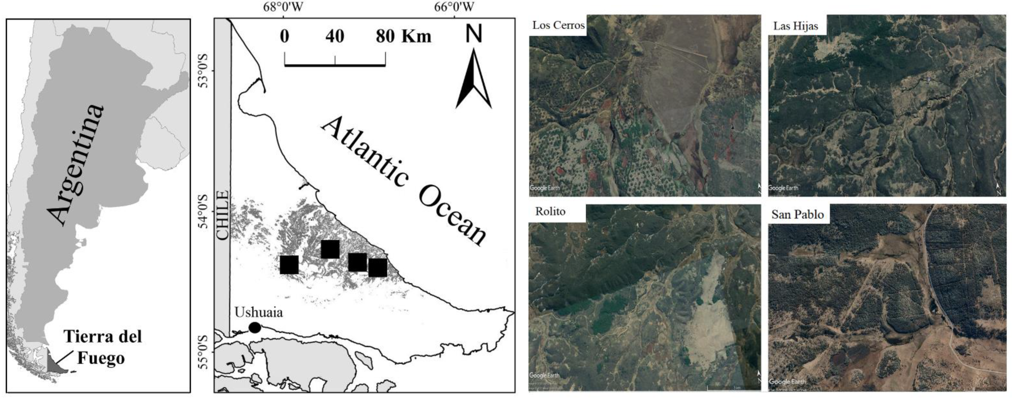
2.1. Study Area

This work was carried out in the central area of Tierra del Fuego province, Argentina, where monospecific N. antarctica forests are dominant (Figure 1). In these forests, N. antarctica trees reach heights of up to 18 m and age of up to 150–200 years old, growing in variable size patches (1 to 200 ha) and occupying 55 m2 ha−1 basal area on average [33]. Livestock is one of the main productive activities; therefore, overgrazing, habitat loss, and the invasion of exotic species (e.g., Hieracium pilosella, Castor canadensis) are the main threats for forest conservation in the study area [34]. The understory of N. antarctica forests includes shrubs (e.g., Berberis buxifolia), forbs (e.g., Galium aparine), grasses (e.g., Bromus unioloides), ferns (e.g., Blechnum penna-marina), and mosses and liverworts. These forests are immersed in a landscape matrix that alternates with open areas such as grasslands and peatlands. Grasslands are dominated by grasses (e.g., Festuca gracillima, Alopecurus magellanicus, Deschampsia antarctica, Hordeum comosum), graminoids (e.g., Carex spp., Juncus scheuchzerioides), and forbs (e.g., Azorella caespitose, Gentianella magellanica, Euphrasia antarctica), while peatlands are mainly composed of Sphagnum magellanicum moss, associated with other species such as Empetrum rubrum, Carex spp., Pernettya pumila, and Gunnera magellanica [35]. The altitude varies between 100 and 250 m a.s.l. and terrain is wavy with gentle slopes, accentuated in foothills. At these latitudes, summer is short and cool. The growing season is approximately 5 months, and only 3 months per year are free from freezing air temperatures (below 0 °C). The mean wind speed outside forests is 8 km h−1, with frequent windstorms in summer that reach 100 km h−1 [36]. The annual rainfall is distributed homogeneously throughout the year, with an average of 400–600 mm yr−1 [37].
Sampling was conducted at four locations (Figure 1) in the central area of Tierra del Fuego: Los Cerros (8900 ha; 54°20′ S, 67°52′ W), Las Hijas (10,000 ha; 54°15′ S, 67°20′ W), Rolito (16,696 ha; 54°17′ S, 67°03′ W), and San Pablo ranches (8481 ha; 54°16′ S, 66°48′ W). The N. antarctica forests cover 1327 ha in Los Cerros, 8100 ha in Rolito, 6300 ha in Las Hijas, and 3202 ha in San Pablo. The main productive activity in this area is livestock cattle breeding (Hereford), with an average animal density of 12 ind km−2. Livestock use in the area dates back approximately 50 years through traditional round-year, extensive grazing in large paddocks (approximately 1000–2000 ha each) that included different ecosystem types (grasslands, peatlands, N. antarctica and N. pumilio forests), with cattle moving freely in the landscape matrix.
In some mature N. antarctica forest patches (1.5–13.5 ha each), forest thinning was conducted by reducing approximately 50% of the original canopy cover to increase understory forage production [32]. Similar harvesting was performed in the four ranches, eliminating mainly not healthy and suppressed-intermediate crown class individuals, and generating a homogeneous remnant and low crown cover that increase understory forage production. In this way, thinning improves the growth of the remaining trees (increasing basal area in the long term), and in the short term, it improves forage provision and the use of forests as animal protection in winter [38]. Wood was mainly used for firewood, poles, and rods for fences.

2.2. Sampling Design

At each location, four habitat types dominated by N. antarctica forests were selected and were associated to four different canopy cover (CC) categories: (i) open forest environments (<35%) corresponding to forest edges and areas where forests advance on grasslands and peatlands, (ii) managed forests with thinning (35–65%), (iii) closed forests (65–85%) corresponding to mature or over-mature structures of primary unmanaged stands, and (iv) very closed forests (>85%) corresponding to young secondary stands with a full stocking density of trees [26]. For each canopy cover category, two replicas at Las Hijas and San Pablo and four replicas at Los Cerros and Rolito were randomly selected at each ranch, and were separated by at least 100 m from each other (N = 48).

2.3. Bird Sampling Methodology

Bird density was obtained with the point count method, using one observation point per replica. Each observation point was revisited 3–4 times each month during middle summer (January and February) in two consecutive years, depending on each location (2017–2020). Each visit consisted of 2 min habituation (time that birds delay in returning to normal activity, when observations are not registered) and 8 min registration (effective observation) following the methodology used by Lencinas et al. [28,30]. Bird observations were carried out during the first 4 h after dawn, when birds showed most social and feeding activities [29]. For each detected bird, as long as it was moving below the forest canopy, the species and the distance (m) to each individual from the center of the point were recorded using a TruPulse laser rangefinder (Laser Technology, Centennial, CO, USA). For bird taxonomy, we followed the South American Classification Committee [39], where species were classified by trophic level (granivores, insectivores, or omnivores) and migratory status (resident or migrant) [28,40,41].
Bird density (ind ha−1) was obtained from censuses according to Lencinas et al. [30]. This methodology estimates the density (for each species) in one variable area, where radius is related to the habitat types, e.g., larger radius in open environments and lower in closed stands (decreasing in detectability with increasing distance). For this study, the radius for density calculation was 25 m in very closed, 32 m in closed, 35 m in thinned, and 40 m in open stands.

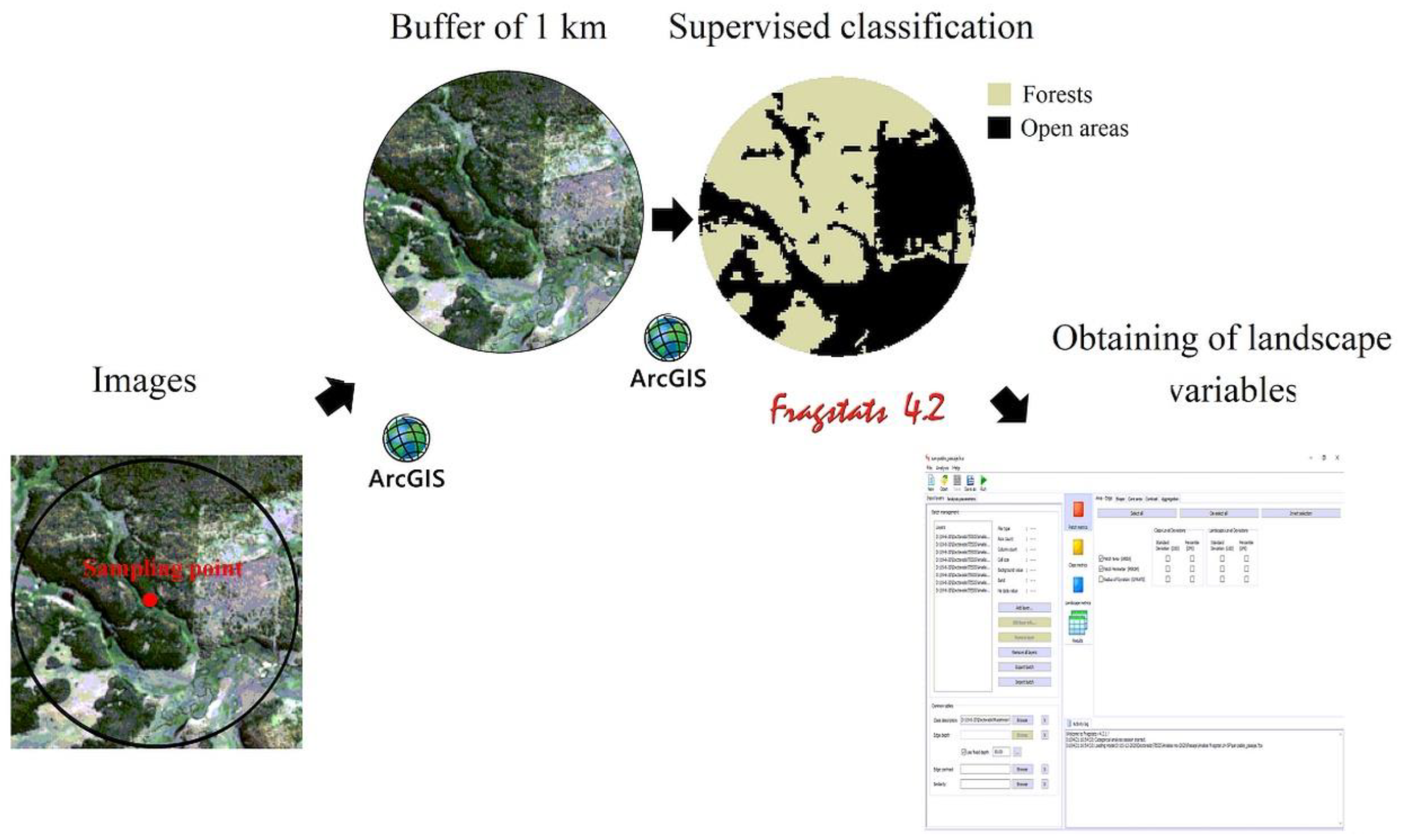
2.4. Landscape Characterization

Landscape variables were obtained using Sentinel-2 images (5 December 2016 for Los Cerros and 13 February 2017 for the other three ranches) with pixels of 10 × 10 m. For each sampling point, an individually buffer of 1-km radius was created using ArcGIS software (ESRI 2011), maintaining that point in the center, and generating a supervised classification to separate forests (N. antarctica and N. pumilio) and open areas (grassland and peatlands) (Figure 2). The landscape composition and configuration within buffers were quantified using Fragstats 4 software [42], obtaining values for three types of variables (Table 1): (1) for forest patches where the count points were found (area, perimeter, and shape), (2) for forest and open area classes (total area, number of patches, largest patch index, and connectivity), and (3) for the entire landscape (total edge and edge density). Details for units and calculations are shown in Table 1. Landscape composition variables were the total forest area and the total open areas. The landscape configuration variables were the area, perimeter, and shape of the forest patches; the number of patches; the largest patch index; and the connectivity calculated for each cover type, the total edge length, and the edge density in the landscape.

2.5. Local Stand Characterization

In the sampled stands, the habitat structure was characterized, evaluating the forest structure and the ground cover. Forest structure was measured by two variable-radius plots per stand [43] with a BAF (1–7) and 50 m distance from each other. Canopy cover (CC, %) was measured with a spherical crown densiometer [44], dominant height (DH, m) with a TruPulse hypsometer-rangefinder (Laser Technology, USA), and diameter at breast height (DBH, cm) with a forest calliper, which allowed calculation of tree density (N, ind ha−1) and basal area (BA, m2 ha−1). Ground cover (%) was measured in an area of 500 m2 around each bird sampling point, using visual estimation and a modification of the “relevé” method proposed by Braun-Blanquet [45] and modified by Lencinas et al. [46]. The considered ground cover types were vascular plant species, debris (coarse and fine woody debris up to 3 cm in diameter), bryophytes (mosses, liverworts, lichens, and fungi), and bare soil without vegetation (see Lencinas et al. [46,47]). The vascular plant species were taxonomically determined following Moore [35], Correa [48], and Zuloaga et al. [49]. Based on this, the ground cover (%) of total understory plants (U), debris (D), bryophytes (B), N. antarctica tree saplings (TS), and bare soil (SO) were calculated for each forest stand.
To characterize potential plant food availability for birds, the cover of plant species serving as potential food for birds was estimated. Based on the information obtained from vegetation, the richness (S plants, nº species) and cover (%) of plant species potentially consumed by birds at each forest stand was calculated, and the results were analyzed as total vegetation (Veg), grasses (Grasses), and dicots (Dicots). Plant species that could be potentially consumed by birds were obtained from the bibliography [40,50,51,52,53].
To estimate the potential arthropod prey available to birds, two survey methods were employed: one sampling method using an attraction trap per forest stand, to characterize food availability at the medium-height stratum level, and a second sampling method using three pitfall traps per forest stand, to characterize food availability at the soil stratum level. The attraction traps [54] were located at 1.5 m height near the center of the stand, with a few drops of soap, water, sucrose, and vinegar as attraction agents, and these remained active for 5 days. Pitfall traps (12 cm diameter, 14 cm height) were buried at soil level, distributed approximately in a straight line (one in the geographical center of the patch and the others 5 m apart), and filled with water and soap as retention agents, remaining active for 14 days. The three pitfall traps of each stand were analyzed jointly as a single sample [55]. In the laboratory, samples were sorted by hand to identify and quantify individuals at the class and order level. We analyzed the total abundance (Ab, ind) of each trap type per forest stand, and the proportional abundance (%) of each order, which was obtained relating the order abundance to the total abundance at each trap.

2.6. Data Analysis

Detrended correspondence analyses (DCA) were carried out, using revisit and bird density (ind ha−1) without down weight for rare species and with axis rescaling [56]. Then, two Canonical Correspondence Analyses (CCA, [57]) were conducted to explore the influence of landscape and local stand variables: the first one including only landscape variables, and the second one combining the two scale variables (landscape + habitat structure and metrics of food availability). A matrix with bird species density was used for each month, year, and sampling site (matrix of 13 species × 192 samples), using habitat type as a classification criterion for the different samplings. The Monte-Carlo method with 499 permutations was employed to test the significance of each axis. These multivariate analyses were performed using CANOCO 5 5.4 © Biometrics 1997–2014 [58].

3. Results

Twenty-one native bird species were identified, of which passerines showed the highest densities (see more details in bird species assemblages at these study sites in [32]. Therefore, only passerines (13 species, 62% of the total birds observed) were selected for the analysis. Although all of these 13 bird species have a conservation status of “least concern” [59], many of them are endemic to the Patagonian region or are migratory and come to the area to reproduce. However, only two species are considered forest specialists (Table 2). Insectivores included the highest number of species (seven species), while the number of resident and migrant species were similar (seven species were residents and six migrants, Table 2). Eight species were common to all habitat types, but species density differed among habitat types (Table 2). Aphrastura spinicauda and Elaenia albiceps were the most abundant species in closed and very closed forests, while in thinned stands A. spinicauda and Spinus barbatus presented the highest density (Table 2). In open forests, Tachycineta leucopyga and E. albiceps were the most abundant species (Table 2).
Forest patch area varied between 0.9 and 203.9 ha, perimeter between 80 and 23,040 m, and shape between 1.0 and 6.9 (Table 3). Total area, number of patches, and connectivity of forest and open areas showed similar minimum and maximum values, while the mean largest patch indexes were higher in open areas (Table 3). Local characteristics were presented by habitat types (Appendix A). Canopy cover followed the previously stated incremental gradient from open to very closed forests (26.4–95.4%), while DH was higher in thinned and closed forests (12.4 and 11.6 m, respectively). Tree density was higher in very closed forests and minimum in thinned stands, and BA followed an incremental gradient from open to very closed forests (Appendix A). Understory cover varied between 69.0% and 87.5%, with the higher values in open forests. Debris and TS were higher in thinned stands, while B was higher in open forests. Soil cover presented higher values in very closed forests (Appendix A). Richness of plants and Veg were higher in closed forest, Grasses in thinned and open forests, and Dicots in very closed forests. The abundance of arthropods captured by attraction traps, ADip, and ACole were higher in very closed, and minimum in thinned, while AHyme and ALep were higher in thinned stands (Appendix A). With respect to arthropods captured by pitfalls, PAb, PDip, and PHyme were higher in very closed forests. PAca and Plarv were higher in thinned, while PCole was higher in closed forests.
In the DCA analysis (Figure 3), there is not a clear split between plots, although closed forests were located closer to very closed forest compared to thinned and open forests, and thinned were intermingled with the others habitat types. Concerning species, some migrant omnivores (Z. capensis and X. pyrope), resident (A. parulus and C. fuscus), and migrant insectivores (T. leucopyga) were located closer to thinned and open forests, while the two resident forest specialists (A. spinicauda and Pygarrhichas albogularis) were located closer to closed and very closed forests. Others resident omnivores (e.g., P. patagonicus) and a migrant (E. albiceps and S. barbatus) did not show a clear association with any habitat types.
When plots were ordered by CCA using landscape variables, the inclusion of explanatory variables improved from 42.3% to 84.2% for the explained total variation. Axis 1 explains 32.2% of the total variance, and Axis 2 explains 30.4% (total inertia = 3.145). Among the 13 landscape variables used in the analyses, 10 were significant for the model (Table 4), so the results are presented using only these variables as explanatory variables. The study sites of all the habitat types were intermingled, without a clear split between them (Figure 4). The two forest specialists (P. albogularis and A. spinicauda) and A. parulus, all resident insectivores, were associated with larger forest patches, while other migratory insectivores (e.g., Troglodytes aedon) were associated with higher edge density and total edge. A ground-foraging insectivore (Cinclodes fuscus) was associated with a higher number of forests and open area patches. On the other hand, three omnivores (Curaeus curaeus, Zonotrichia capensis, and Xolmis pyrope) were associated with edge density, total edge, and number of patches of open areas, while another species of this trophic group was mostly associated with greater quantities of forest patches (Turdus falklandii). Only one granivore (S. barbatus) presented a higher abundance in landscapes with larger total open areas, while two migrant species (E. albiceps and T. leucopyga) showed little association with any landscape variable.
When the landscape and the local stand variables were analyzed, the inclusion of explanatory variables improved from 42.3% to 81.7% for the explained total variation. Although the value explained by these variables was slightly lower than the previous analysis, graphically the distribution of the species and plots were better appreciated in this analysis. Axis 1 and Axis 2 explained 32.3% and 25.2%, respectively, of the total variance (total inertia = 3.145). Among the 38 variables (13 of landscape and 25 of local stand), 9 were significant for this analysis (Table 4). Plots were grouped by habitat types (Figure 4), with closed forests mixed with very closed at one side, thinned stands in the center, and open forests at the other side. Regarding bird species, it is observed that they were clearly separated into two groups. Two resident forest specialists (P. albogularis and A. spinicauda) and one migrant (E. albiceps) were associated with closed and very closed forests and were related to high values of canopy cover, plant species potentially consumed by birds, and the abundance of arthropods captured with pitfall traps. On the other hand, three omnivores (Z. capensis, T. falcklandii, and X. pyrope) and two insectivores (A. parulus and C. fuscus) were associated with open forests and higher values of tree sapling cover, as well as the proportion of Hymenoptera captured with attraction traps.

4. Discussion

Despite the low timber aptitude of N. antarctica trees, these forests represent an important natural resource for firewood and poles, and they also offer a higher understory richness and biomass than other forest types in the region, which allow the development of livestock use and silvopastoral management [24], and are therefore of special interest for conservation [60,61]. Due to historically uncontrolled use, N. antarctica forests are significantly degraded in certain places of the Patagonia region [62,63,64]. In addition, the study of the bird assemblages in these forests is relevant for conservation, because in these latitudes, birds occupy many niches and key ecological roles, e.g., [65]. However, we have little knowledge about the relationships between them, and with the resources offered by N. antarctica forests.
Landscape configuration (area, perimeter, and shape of patches; number of patches; largest patch index) and composition (area of open areas) variables significantly influenced the bird assemblages in the studied forests, in agreement with Calamari and Zaccagnini [9] and Carrara et al. [2]. They are also in agreement with other studies, for example [7,66]; our results reject the habitat size hypothesis proposed by Fahrig [67] because it was found that not only the composition (OTA variable) but also the configuration (AREA, PERIM, SHAPE, FNP, ONP, OLPI, OCONNECT, TE, and ED) of the landscape influenced the assemblage of birds. As observed by Klingbeil and Willig [14], migratory birds (e.g., E. albiceps and T. leucopyga) showed a very weak association with landscape variables, which could be associated with the fact that these are long-distance migrants capable of adapting to many different environments [51,68]. However, a partial migratory species (S. barbatus) was associated with higher values of total area of open areas, while two other migrant species (Z. capensis and T. aedon) were associated with forests with more edges and a greater number of open areas patches. This could be due to these species using forests for nesting and open areas for feeding seeds and arthropods [31,50,69]. However, the species that showed the greatest influence of landscape variables were two residents and habitat generalist species: C. fuscus and T. falcklandii. These species were associated with a greater number of patches, as was also observed by Carrara et al. [2] with other habitat generalist species. On the other hand, similar results were found in other forests [2,70], where other forest specialists, such as P. albogularis, were associated with larger forest patches. This is an indication that this species may be sensitive to the decreasing of the forest patch area and fragmentation processes. Although A. spinicauda, another forest specialist species, was also influenced by the size of the forest patches, this association was weaker, probably because this specie used thinned stands and forest edges at these latitudes [32].
When we evaluate the influence of landscape variables together with the local stand characteristics, both variables influenced the bird assemblage. Landscape configuration (e.g., forest patch shape) and the habitat structure (e.g., canopy cover) and food availability (e.g., cover of plants consumed by birds) were the most associated with the composition and density of bird species. The forest specialists (P. albogularis and A. spinicauda) were associated with greater canopy cover, a characteristic that can indicate the better sites for nesting and feeding. This differs from what was observed by Smith et al. [70], who found that forest specialists are strongly associated with the total forest area in the landscape. However, this difference could be produced because the forest area around most of the sampling sites in this study is above the threshold beyond which no effects of habitat loss are observed. At the landscape level, thresholding occurs when the response of a species or group of species to habitat loss is not linear, but instead changes abruptly at a certain level of habitat loss [71]. Carrying out studies that include sampling in more areas with a lower proportion of forests could help to determine if there is a threshold from which the forest specialist species are affected, as suggested by the threshold theory. On the other hand, insectivores and omnivores that use low strata to nest and/or feed (e.g., T. falcklandii, A. parulus, and Z. capensis) were associated with landscape configuration variables (shape of the patch and total edge) and sapling cover in the forests. This could occur because more irregular forest patches would generate a more heterogeneous landscape that would provide greater diversity of resources for insectivores and omnivores. At the same time, high sapling cover into the forests can provides great opportunities to nest and feed for these species. As for migrant and residents, a very clear trend was not observed. It should be considered that the increasing in the length of edges due to forest fragmentation could increase the density of some residents (A. parulus, C. curaeus, and T. falcklandii).
These results suggest that different bird species respond to habitat characteristics at different spatial scales (local stand vs. landscape) as has also been observed by other authors [16,70]. Forest specialist species were more related to forest structure variables (canopy cover), as was observed by Muhamad et al. [72] and Menon et al. [73], and other habitat characteristics at the local stand level (understory plants and abundance of arthropofauna), as was observed be Vergara and Schlatter [74], Stratford and Stouffer [75], and Cahill et al. [76]. Therefore, these species may be more sensitive to activities (e.g., clear cutting, thinning) that result in a reduction of canopy cover below 80% and decreasing abundance of arthropods below 1000 ind per trap. On the other hand, insectivorous or omnivorous bird species that use low strata and open areas were more associated with landscape configuration variables (e.g., more irregular forest patches, total edge) as Carrara et al. [2] observed, but also with other local variables such as the proportion of arthropods (e.g., Hymenoptera) and cover of intermediate stratum trees (saplings). Thus, these species would be more influenced by activities that reduce the lengths of edges below 30 km (e.g., due to increase or regrowth of the forests) or change the patch shape to squarer patches, but also by those that decrease sapling cover (below 3%), for example, due to high grazing intensity [77], or using ground-based extraction systems (skidders) and cable yarders [78]. The implementation or avoidance of particular practices that modify influential variables at different spatial scales can improve the effectiveness of management and conservation strategies.

5. Conclusions

Landscape configuration and composition variables significantly influence bird assemblages in the Nothofagus antarctica forests of Tierra del Fuego. When analyzed jointly with local stand variables, landscape configuration becomes more important. Canopy cover, patch shape, tree saplings, total edge, richness and cover of plants consumed by birds, abundance of arthropods, and proportion of Hymenoptera influenced the bird assemblage, demonstrating the complexity of the system. Our study highlights the importance of maintaining forests with high canopy cover to conserve forest specialist birds, and irregular parches, higher number of edges, and sapling cover to benefit insectivorous or omnivorous bird species that use low strata and open areas. The use of multiple spatial scales allows us to better understand which variables are associated with the whole assemblage and with the different bird species, as well as which modifications at local or landscape level could affect them.

Author Contributions

Conceptualization, J.B., M.V.L. and M.D.B.; methodology, J.B., M.V.L. and G.J.M.P.; validation, J.B.; formal analysis, J.B. and Y.M.R.; investigation, J.B. and M.V.L.; resources, J.B., M.V.L. and G.J.M.P.; data curation, J.B.; writing—original draft preparation, J.B. and M.V.L.; writing—review and editing, M.V.L., G.J.M.P. and M.D.B.; visualization, J.B.; supervision, M.V.L.; project administration, J.B. and M.V.L.; funding acquisition, J.B. and M.V.L. All authors have read and agreed to the published version of the manuscript.

Funding

This research was funded by ANPCyT-MINCyT (Argentina), grant number PICT-2016-1968.

Institutional Review Board Statement

Not applicable.

Informed Consent Statement

Not applicable.

Data Availability Statement

Not applicable.

Acknowledgments

This research is part of the doctoral thesis of J.B. (Faculty of Ciencias Agrarias y Forestales in the Universidad Nacional de la Plata). We would especially like to thank C. Henninger and the Luna family for allowing our entry and sampling in their ranches and I. Ramos Vértiz and A. Pellegrinuzzii for their help during sampling.

Conflicts of Interest

The authors declare no conflict of interest.

Appendix A

Table A1. Mean and standard deviation values of stand characteristics (habitat structure and food availability) by habitat types analyzed for Nothofagus antarctica forests in Tierra del Fuego (Argentina).
Stand CharacteristicsHabitat Types
Very Closed
(>85% CC)
Closed
(65–85% CC)
Thinned
(35–65% CC)
Open
(<35% CC)
Habitat structure characteristics
Canopy coverCC (%)95.4 ± 7.382.2 ± 12.058.5 ± 12.526.4 ± 9.6
Dominant heightDH (m)10.1 ± 2.211.6 ± 3.012.4 ± 1.610.4 ± 136.8
Diameter at breast heightDBH (cm)18.6 ± 4.637.5 ± 10.741.8 ± 9.619.0 ± 6.3
Tree densityN (ind ha−1)2892.7 ± 1332.2626.3 ± 533.0249.8 ± 136.8416.4 ± 13.1
Basal areaBA (m2 ha−1)47.1 ± 16.634.3 ± 6.622.3 ± 6.37.3 ± 9.3
Understory plants coverU (%)69.0 ± 20.973.4 ± 5.677.0 ± 19.587.5 ± 12.3
Debris coverD (%)14.4 ± 9.514.8 ± 4.014.9 ± 9.31.4 ± 7.2
Bryophytes coverB (%)4.0 ± 1.37.1 ± 4.03.2 ± 3.88.4 ± 6.4
Tree saplings coverTS (%)0.3 ± 0.91.4 ± 2.65.0 ± 7.24.0 ± 1.4
Bare soil coverSO (%)12.6 ± 11.94.8 ± 2.84.9 ± 3.02.7 ± 3.8
Food availability characteristics
Richness of plantsS plant (n° species)6.3 ± 1.79.1 ± 2.18.7 ± 1.46.8 ± 2.9
Plants coverVeg (%)49.6 ± 19.550.2 ± 7.749.3 ± 6.441.0 ± 21.0
Grasses coverGrasses (%)30.7 ± 23.136.7 ± 11.936.9 ± 4.736.9 ± 19.7
Dicots coverDicots (%)18.9 ± 16.413.5 ± 9.912.4 ± 9.03.6 ± 4.3
Abundance of arthropods captured by attraction trapsAAb (n° ind)3202.1 ± 4826.51845.4 ± 2457.8367.0 ± 320.03080.3 ± 3657.8
Proportion of Diptera captured by attraction trapsADip (%)93.3 ± 4.490.0 ± 8.870.5 ± 17.787.9 ± 9.9
Proportion of Hymenoptera captured by attraction trapsAHyme (%)2.2 ± 2.25.0 ± 7.120.5 ± 19.64.4 ± 6.3
Proportion of Lepidoptera captured by attraction trapsALep (%)3.1 ± 3.34.0 ± 3.07.4 ± 9.27.2 ± 9.2
Proportion of Coleoptera captured by attraction trapsACole (%)1.3 ± 1.60.9 ± 1.41.2 ± 1.60.3 ± 0.3
Abundance of arthropods captured by pitfallsPAb (n° ind)1100.3 ± 1262.0303.8 ± 258.8299.5 ± 223.8536.6 ± 640.5
Proportion of Diptera captured by pitfallsPDip (%)74.2 ± 16.056.0 ± 14.445.1 ± 23.263.2 ± 20.5
Proportion of Hymenoptera captured by pitfallsPHyme (%)6.7 ± 4.24.1 ± 5.72.6 ± 3.04.1 ± 3.2
Proportion of Acarina captured by pitfallsPAca (%)5.1 ± 6.24.9 ± 4.310.2 ± 9.16.9 ± 7.5
Proportion of Coleoptera captured by pitfallsPCole (%)5.0 ± 3.816.6 ± 9.114.2 ± 10.712.2 ± 8.3
Proportion of larvae captured by pitfallsPLarv (%)3.8 ± 3.84.9 ± 3.69.0 ± 10.23.4 ± 3.1

References

  1. Brandolin, P.G.; Blendinger, P.G. Effect of habitat and landscape structure on waterbird abundance in wetlands of central Argentina. Wetl. Ecol. Manag. 2015, 24, 93105. [Google Scholar] [CrossRef]
  2. Carrara, E.; Arroyo-Rodríguez, V.; Vega-Rivera, J.H.; Schondube, J.E.; de Freitas, S.M.; Fahrig, L. Impact of landscape composition and configuration on forest specialist and generalist bird species in the fragmented Lacandona rainforest, Mexico. Biol. Conserv. 2015, 184, 117–126. [Google Scholar] [CrossRef]
  3. Dixon, A.P.; Baker, M.E.; Ellis, E.C. Agricultural landscape composition linked with acoustic measures of avian diversity. Land 2020, 9, 145. [Google Scholar] [CrossRef]
  4. Dunning, J.B.; Danielson, B.J.; Pulliam, H.R. Ecological processes that affect populations in complex landscapes. Oikos 1992, 65, 169–175. [Google Scholar] [CrossRef]
  5. McGarigal, K.; Marks, B.J. Fragstats: Spatial Pattern Analysis Program for Quantifying Landscape Structure; US Forest Service Pacific Northwest Research Station: Portland, OR, USA, 1995; 122p. [Google Scholar]
  6. Bonfim, F.C.G.; Dodonov, P.; Cazetta, E. Landscape composition is the major driver of the taxonomic and functional diversity of tropical frugivorous birds. Landsc. Ecol. 2021, 36, 2535–2547. [Google Scholar] [CrossRef]
  7. Haddad, N.M.; Gonzalez, A.; Brudvig, L.A.; Burt, M.A.; Levey, D.J.; Damschen, E.I. Experimental evidence does not support the habitat amount hypothesis. Ecography 2017, 40, 48–55. [Google Scholar] [CrossRef]
  8. Ewers, R.M.; Didham, R.K. Confounding factors in the detection of species responses to habitat fragmentation. Biol. Rev. 2006, 81, 117–142. [Google Scholar] [CrossRef]
  9. Calamari, N.C.; Zaccagnini, M.E. Respuesta de las aves a la fragmentación del monte nativo entrerriano: Implicancias para la conservación y la agricultura sustentable (Response of birds to the fragmentation of the native forest in Entre Ríos: Implications for conservation and sustainable agriculture). In Agricultura Sustentable en Entre Ríos (Sustainable Agriculture in Entre Ríos); Caviglia, O.P., Paparotti, O.F., Sasal, M.C., Eds.; Ediciones INTA: Buenos Aires, Argentina, 2007; pp. 119–125. [Google Scholar]
  10. Vala, M.A.; Mitchell, G.W.; Hannah, K.C.; Put, J.; Wilson, S. The effects of landscape composition and configuration on Eastern Whip-poor-will (Caprimulgus vociferous) and Common Nighthawk (Chordeiles minor) occupancy in an agroecosystem. Avian Conserv. Ecol. 2020, 15, 24. [Google Scholar] [CrossRef]
  11. Baltag, E.S.; Pocora, V.; Bolboaca, L.E.; Ion, C. The Importance of Low-Intensive Agricultural Landscape for Birds of Prey. Land 2021, 10, 252. [Google Scholar] [CrossRef]
  12. Polis, G.A.; Power, M.E.; Huxel, G.R. Food Webs at the Landscape Level; University of Chicago Press: Chicago, IL, USA, 2004. [Google Scholar]
  13. Uezu, A.; Metzger, J.P. Vanishing bird species in the Atlantic Forest: Relative importance of landscape configuration, forest structure and species characteristics. Biodivers. Conserv. 2011, 20, 3627–3643. [Google Scholar] [CrossRef]
  14. Klingbeil, B.T.; Willig, M.R. Matrix composition and landscape heterogeneity structure multiple dimensions of biodiversity in temperate forest birds. Biodivers. Conserv. 2016, 25, 2687–2708. [Google Scholar] [CrossRef]
  15. Calamari, N.C.; Vilella, F.J.; Sica, Y.V.; Mercuri, P.A. Patch and landscape responses of bird abundance to fragmentation in agroecosystems of east-central Argentina. Avian Conserv. Ecol. 2018, 13, 3. [Google Scholar] [CrossRef]
  16. Bhakti, T.; Goulart, F.; de Azevedo, C.S.; Antonini, Y. Does scale matter? The influence of three-level spatial scales on forest bird occurrence in a tropical landscape. PLoS ONE 2018, 13, e0198732. [Google Scholar] [CrossRef] [PubMed]
  17. Kennedy, C.M.; Campbell Grant, E.H.; Neel, M.C.; Fagan, W.F.; Marra, P.P. Landscape matrix mediates occupancy dynamics of Neotropical avian insectivores. Ecol. Appl. 2011, 21, 1837–1850. [Google Scholar] [CrossRef]
  18. Cornell, H.V.; Karlson, R.H. Local and regional processes as controls of species richness. In Spatial Ecology: The Role of Space in Population Dynamics and Interspecific Interactions; Tilman, D., Kareiva, P., Eds.; Princeton University Press: Princeton, NY, USA, 1997; pp. 250–268. [Google Scholar]
  19. Estades, C.F.; Temple, S.A. Deciduous-forest bird communities in a fragmented landscape dominated by exotic pine plantations. Ecol. Appl. 1999, 9, 573–585. [Google Scholar] [CrossRef]
  20. Mörtberg, U.M. Resident bird species in urban forest remnants, landscape and habitat perspectives. Landsc. Ecol. 2001, 16, 193–203. [Google Scholar] [CrossRef]
  21. Peri, P.L.; Lencinas, M.V.; Bousson, J.; Lasagne, R.; Soler, R.; Bahamonde, H.; Martínez Pastur, G. Biodiversity and ecological long-term plots in Southern Patagonia to support sustainable land management: The case of PEBANPA network. J. Nat. Conserv. 2016, 34, 51–64. [Google Scholar] [CrossRef]
  22. Collado, L. Los bosques de Tierra del Fuego. Análisis de su estratificación mediante imágenes satelitales para el inventario forestal de la provincia (The forests of Tierra del Fuego. Analysis of its stratification through satellite images for the forest inventory of the province). Multequina 2001, 10, 15. [Google Scholar]
  23. Gea-Izquierdo, G.; Martínez Pastur, G.; Cellini, J.M.; Lencinas, M.V. Forty years of silvicultural management in southern Nothofagus pumilio primary forests. For. Ecol. Manag. 2004, 201, 335–347. [Google Scholar] [CrossRef]
  24. Peri, P.L.; Hansen, N.E.; Bahamonde, H.A.; Lencinas, M.V.; von Müller, A.R.; Ormaechea, S.; Gargaglione, V.; Soler, R.M.; Tejera, L.; Lloyd, C.E.; et al. Silvopastoral systems under native forest in Patagonia, Argentina. In Silvopastoral Systems in Southern South America; Peri, P.L., Dube, F., Varella, A., Eds.; Series: Advances in Agroforestry; Springer: Bern, Switzerland, 2016; Volume 11, pp. 117–168. [Google Scholar] [CrossRef]
  25. Peri, P.L.; Caballé, G.; Hansen, N.E.; Bahamonde, H.A.; Lencinas, M.V.; Von Müller, A.R.; Ormaechea, S.; Gargaglione, V.; Soler, R.; Sarasola, M.; et al. Silvopastoral systems in Patagonia, Argentina. In Temperate Agroforestry Systems; Gordon, A.M., Newman, S.M., Coleman, B.R.W., Eds.; CABI: Boston, MA, USA, 2017; pp. 252–273. [Google Scholar]
  26. Perera, A.; Peterson, U.; Martínez Pastur, G.; Iverson, L. Ecosystem Services from Forest Landscapes: Broadscale Considerations; Springer: Cham, Switzerland, 2018; p. 265. [Google Scholar]
  27. Martínez Pastur, G.; Schlichter, T.; Matteucci, S.D.; Gowda, J.H.; Huertas Herrera, A.; Toro Manríquez, M.; Lencinas, M.V.; Cellini, J.M.; Peri, P.L. Synergies and trade-offs of national conservation policy and agro-forestry management over forest loss in Argentina during the last decade. In Latin America in Times of Global Environmental Change; Lorenzo, C., Ed.; Springer: Cham, Switzerland, 2020; pp. 135–155. [Google Scholar]
  28. Lencinas, M.V.; Martínez Pastur, G.; Medina, M.; Busso, C. Richness and density of birds in timber Nothofagus pumilio forests and their unproductive associated environments. Biodivers. Conserv. 2005, 14, 2299–2320. [Google Scholar] [CrossRef]
  29. Deferrari, G.; Camilión, C.; Martínez Pastur, G.; Peri, P.L. Changes in Nothofagus pumilio forest biodiversity during the forest management cycle. 2. Birds. Biodivers. Conserv. 2001, 10, 2093–2108. [Google Scholar] [CrossRef]
  30. Lencinas, M.V.; Martínez Pastur, G.; Gallo, E.; Cellini, J.M. Alternative silvicultural practices with variable retention improve bird conservation in managed South Patagonian forests. For. Ecol. Manag. 2009, 258, 472–480. [Google Scholar] [CrossRef]
  31. Lencinas, M.V.; Cellini, J.M.; Benitez, J.; Peri, P.L.; Martínez Pastur, G. Variable retention forestry conserves habitat of bird species in Patagonian Nothofagus pumilio forests. Ann. For. Res. 2018, 61, 147–160. [Google Scholar] [CrossRef]
  32. Benitez, J.; Barrera, M.D.; Sola, F.J.; Blazina, A.P.; Martínez Pastur, G.J.; Peri, P.L.; Lencinas, M.V. Effects of long-term low intensity silviculture and habitat on birds in Nothofagus antarctica forests of south Patagonia. For. Ecol. Manag. 2022, 516, 120254. [Google Scholar] [CrossRef]
  33. Ivancich, H.S. Relaciones Entre la Estructura Forestal y el Crecimiento del Bosque de Nothofagus antarctica en Gradientes de edad y Calidad de Sitio. Ph.D. Thesis, Universidad Nacional de La Plata, La Plata, Argentina, 2013. [Google Scholar] [CrossRef]
  34. Peri, P.L. Sistemas silvopastoriles en bosques de Nothofagus antarctica. Revisión del conocimiento actual en Patagonia Sur, Argentina. (Silvopastoral systems in Nothofagus antarctica forests. Review of current knowledge in South Patagonia, Argentina). Cienc. Investig. For. 2011, 17, 217–242. [Google Scholar] [CrossRef]
  35. Moore, D. Flora of Tierra del Fuego; Missouri Botanical Garden: London, UK, 1983; 395p. [Google Scholar]
  36. Martínez Pastur, G.J.; Cellini, J.M.; Lencinas, M.V.; Barrera, M.; Peri, P.L. Environmental variables influencing regeneration of Nothofagus pumilio in a system with combined aggregated and dispersed retention. For. Ecol. Manag. 2011, 261, 178–186. [Google Scholar] [CrossRef]
  37. Soler, R.; Martínez Pastur, G.; Lencinas, M.V.; Borrelli, L. Differential forage use between large native and domestic herbivores in Southern Patagonian Nothofagus forests. Agrofor. Syst. 2012, 85, 397–409. [Google Scholar] [CrossRef]
  38. Peri, P.L.; Martínez Pastur, G.; Monelos, L.; Livraghi, E.; Allogia, M.; Christiansen, R.; Sturzenbaum, M.V. Sistemas silvopastoriles en bosques nativos de ñire: Una estrategia para el desarrollo sustentable en la Patagonia Sur (Silvopastoral systems in native ñire forests: A strategy for sustainable development in South Patagonia). In Dinámicas Mundiales, Integración Regional y Patrimonio en Espacios Periféricos (Global Dynamics, Regional Integration and Heritage in Peripheral Spaces), 1st ed.; Zárate, R., Artesi, L., Eds.; Universidad Nacional de la Patagonia Austral: Río Gallegos, Argentina, 2005; pp. 251–259. [Google Scholar]
  39. A Classification of the Bird Species of South America. Available online: www.museum.lsu.edu/~Remsen/SACCBaseline.htm (accessed on 8 April 2020).
  40. Humphrey, P.S.; Peterson, D.; Reynolds, R.T.; Humphrey, P.W. Preliminary Smithsonian Manual: Birds of Isla Grande (Tierra del Fuego); Smithsonian Institute Press: Washington, DC, USA; University of Kansas Museum of Natural History: Lawrence, KS, USA, 1970; 441p. [Google Scholar]
  41. Pizarro, J.C.; Anderson, C.B.; Rozzi, R. Birds as marine-terrestrial linkages in sub-polar archipelagic systems: Avian community composition, function and seasonal dynamics in the Cape Horn Biosphere Reserve (54-55 S), Chile. Polar Biol. 2012, 35, 39–51. [Google Scholar] [CrossRef]
  42. McGarigal, K.; Cushman, S.A.; Ene, E. FRAGSTATS v4: Spatial Pattern Analysis Program for Categorical and Continuous Maps Computer Software Program Produced by the Authors at the University of Massachusetts, Amherst. Available online: http://www.umass.edu/landeco/research/fragstats/fragstats.html (accessed on 20 July 2020).
  43. Bitterlich, W. Die Winkelzählprobe. Allgemeine Forst und Holzwirtschaftliche Zeitung 1947, 58, 94–96. [Google Scholar]
  44. Lemmon, P.E. A new instrument for measuring forest overstory density. J. For. 1957, 55, 667668. [Google Scholar]
  45. Braun-Blanquet, J. Fitosociología: Bases Para el Estudio de las Comunidades Vegetales; Blume: Madrid, Spain, 1979; 820p. [Google Scholar]
  46. Lencinas, M.V.; Martínez Pastur, G.; Gallo, E.; Cellini, J.M. Alternative silvicultural practices with variable retention to improve understory plant diversity conservation in southern Patagonian forests. For. Ecol. Manag. 2011, 262, 1236–1250. [Google Scholar] [CrossRef]
  47. Lencinas, M.V.; Martínez Pastur, G.; Gallo, E.; Cellini, J.M. Decreasing negative impacts of harvesting over insect diversity using variable retention silviculture in southern Patagonian forests. J. Insect Conserv. 2014, 18, 479–495. [Google Scholar] [CrossRef]
  48. Correa, M.N. Flora Patagónica (Patagonian Flora); Colección Científica Instituto Nacional de Tecnología Agropecuaria: Buenos Aires, Argentina, 1969–1998. [Google Scholar]
  49. Zuloaga, F.O.; Belgrano, M.J.; Zanotti, C.A. Actualización del catálogo de las plantas vasculares del Cono Sur (Updating of the catalog of vascular plants of the Southern Cone). Darwiniana 2019, 7, 208–278. [Google Scholar] [CrossRef]
  50. Archuby, D.; Marti, L.; Montalti, D.; Soave, G.; Camperi, A.; Arambarri, A.; Darrieu, C.A. Alimentación del cabecita negra austral (Carduelis barbata) durante el otoño (Feeding of the Austral blackhead (Carduelis barbata) during the autumn). Hornero 2007, 22, 65–68. [Google Scholar]
  51. Brown, C.E.; Anderson, C.B.; Ippi, S.; Sherriffs, M.F.; McGehee, S.; Rozzi, R. Autoecología del Fío-Fío (Elaenia albiceps Lafresnaye &D’Orbigny) en los Bosques Subantárticos de la Reserva de Biosfera Cabo de Hornos, Chile (Autoecology of the Fío-Fío (Elaenia albiceps Lafresnaye & D’Orbigny) in the Subantarctic Forests of the Cape Horn Biosphere Reserve, Chile). An. Inst. Patagon. 2007, 35, 2940. [Google Scholar]
  52. McGehee, S.M.; Eitniear, J.C. Diet of the patagonian Sierra-finch (Phrygilus patagonicus) on Navarino island, Chile. Ornitol. Neotrop. 2007, 18, 449–452. [Google Scholar]
  53. Díaz, S. Biología y conservación de la cachaña (Enicognathus ferrugineus) en Argentina (Biology and conservation of cachaña (Enicognathus ferrugineus) in Argentina). Hornero 2012, 27, 17–25. [Google Scholar]
  54. Muirhead-Thomson, R.S. Trap Responses of Flying Insects; Academic Press: San Diego, CA, USA, 1991. [Google Scholar]
  55. Cheli, G.H.; Corley, J.C. Efficient sampling of ground-dwelling arthropods using pitfall traps in arid steppes. Neotrop. Entomol. 2010, 39, 912–917. [Google Scholar] [CrossRef]
  56. Hill, M.O. DECORANA A FORTRAN Program for Detrended Correspondence Analysis and Reciprocal Averaging; Section of Ecology and Systematics, Cornell University: Ithaca, NY, USA, 1979. [Google Scholar]
  57. Ter Braak, C.J.F. Canonical correspondence analysis: A new eigenvector method for multivariate direct gradient analysis. Ecology 1986, 67, 1167–1179. [Google Scholar] [CrossRef]
  58. Ter Braak, C.J.F.; Šmilauer, P. CANOCO Reference Manual and CanoDraw for Windows User’s Guide: Software for Canonical Community Ordination (Version 4.5); Ithaca (MicrocomputerPower): New York, NY, USA, 2002; 500p. [Google Scholar]
  59. Birdlife International. Available online: Birdlife.org (accessed on 14 June 2022).
  60. Gönc, R.L. 2013. Estudio de la Estructura de las Comunidades de Artrópodos Asociados a Ñirantales (Nothofagus antarctica) del centro-oeste de la Provincia del Chubut, Patagonia Argentina, Sometidos a Diferentes Tipos de Impacto Ambiental (Study of the Structure of the Communities of Arthropods Associated with Ñirantales (Nothofagus antarctica) in the Center-West of the Province of Chubut, Patagonia Argentina, Under Different Types of Environmental Impact). Ph.D. Thesis, Universidad Nacional de la Plata, La Plata, Argentina, 2013. [Google Scholar]
  61. Rosas, Y.M. Correlación Espacial Entre las Diferentes Estrategias de uso en Patagonia Sur, la Provisión de los Servicios Ecosistémicos y la Conservación de la Biodiversidad (Spatial Correlation between the Different Use Strategies in South Patagonia, the Provision of Ecosystem Services and the Conservation of Biodiversity). Ph.D. Thesis, Universidad Nacional de la Plata, La Plata, Argentina, 2020. [Google Scholar]
  62. Veblen, T.T.; Donoso, C.; Kitzberger, T.; Rebertus, A.J. Ecology of southern Chilean and Argentinean Nothofagus forests. In Ecology and Biogeography of Nothofagus Forests; Veblen, T.T., Hill, R.S., Read, J., Eds.; Yale University Press: London, UK, 1996; pp. 293–353. [Google Scholar]
  63. Veblen, T.T.; Kitzberger, T.; Raffaele, E.; Lorenz, D.C. Fire history and vegetation changes in northern Patagonia, Argentina. In Fire and Climatic Change in Temperate Ecosystems of the Western Americas; Veblen, T.T., Baker, W.L., Montenegro, G., Swetnam, T.W., Eds.; Springer: New York, NY, USA, 2003; pp. 265–295. [Google Scholar]
  64. Vettese, E.S.; Villalba, R.; Orellana Ibáñez, I.A.; Peri, P.L. Tree-growth variations of Nothofagus antarctica related to climate and land use changes in Southern Patagonia, Argentina. In Latin American Dendroecology; Pompa-García, M., Camarero, J.J., Eds.; Springer: Berlin/Heidelberg, Germany, 2020; pp. 331–354. [Google Scholar]
  65. Bravo, S.P.; Cueto, V.R.; Gorosito, C.A. Migratory timing, rate, routes and wintering areas of White-crested Elaenia (Elaenia albiceps chilensis), a key seed disperser for Patagonian forest regeneration. PLoS ONE 2017, 12, e0170188. [Google Scholar] [CrossRef]
  66. Csikós, N.; Szilassi, P. Modelling the Impacts of Habitat Changes on the Population Density of Eurasian Skylark (Alauda arvensis) Based on Its Landscape Preferences. Land 2021, 10, 306. [Google Scholar] [CrossRef]
  67. Fahrig, L. Rethinking patch size and isolation effects: The habitat amount hypothesis. J. Biogeogr. 2013, 40, 1649–1663. [Google Scholar] [CrossRef]
  68. Capllonch, P. Migraciones de aves en el litoral Argentino (Bird migrations in the Argentine coast). Miscelánea 2004, 12, 363–368. [Google Scholar]
  69. Bellocq, M.I.; Filloy, J.; Zurita, G.A.; Apellaniz, M.F. Responses in the abundance of generalist birds to environmental gradients: The rufous-collared sparrow (Zonotrichia capensis) in the southern Neotropics. Ecoscience 2011, 18, 354–362. [Google Scholar] [CrossRef]
  70. Smith, A.C.; Fahrig, L.; Francis, C.M. Landscape size affects the relative importance of habitat amount, habitat fragmentation, and matrix quality on forest birds. Ecography 2011, 34, 103–113. [Google Scholar] [CrossRef]
  71. Toms, J.D.; Lesperance, M.L. Piecewise regression: A tool for identifying ecological thresholds. Ecology 2003, 84, 2034–2041. [Google Scholar] [CrossRef]
  72. Muhamad, D.; Okubo, S.; Miyashita, T.; Takeuchi, K. Effects of habitat type, vegetation structure, and proximity to forests on bird species richness in a forest–agricultural landscape of West Java, Indonesia. Agrofor. Syst. 2013, 87, 1247–1260. [Google Scholar] [CrossRef]
  73. Menon, T.; Sridhar, H.; Shahabuddin, G. Effects of extractive use on forest birds in Western Himalayas: Role of local and landscape factors. For. Ecol. Manag. 2019, 448, 457–465. [Google Scholar] [CrossRef]
  74. Vergara, P.M.; Schlatter, R.P. Aggregate retention in two Tierra del Fuego Nothofagus forests: Short-term effects on bird abundance. For. Ecol. Manag. 2006, 225, 213–224. [Google Scholar] [CrossRef]
  75. Stratford, J.A.; Stouffer, P.C. Forest fragmentation alters microhabitat availability for Neotropical terrestrial insectivorous birds. Biol. Conserv. 2015, 188, 109–115. [Google Scholar] [CrossRef]
  76. Cahill, J.R.A.; Merckx, T.; Van Dyck, H.; Fernandez, M.; Matthysen, E. Lower density of arthropod biomass in small high-Andes Polylepis fragments affects habitat use in insectivorous birds. Ecosphere 2021, 12, e03401. [Google Scholar] [CrossRef]
  77. Barzan, F.R.; Bellis, L.M.; Dardanelli, S. Livestock grazing constrains bird abundance and species richness: A global meta-analysis. Basic Appl. Ecol. 2021, 56, 289–298. [Google Scholar] [CrossRef]
  78. Picchio, R.; Mederski, P.S.; Tavankar, F. How and how much, do harvesting activities affect forest soil, regeneration and stands? Curr. For. Rep. 2020, 6, 115–128. [Google Scholar] [CrossRef]
Figure 1. Location of study area (in black squares, from west to east: Los Cerros, Las Hijas, Rolito, and San Pablo ranches) and Nothofagus antarctica forests (grey) in Tierra del Fuego, Argentina. In the right panel, satellite images of the study area at each ranch.
Land 11 01332 g001
Figure 2. Graphical summary of the methodology to obtain landscape variables of Nothofagus antarctica in Tierra del Fuego, Argentina.
Land 11 01332 g002
Figure 3. DCA ordination of Nothofagus antarctica forests (very closed, closed, thinned, and open) based on bird density data in Tierra del Fuego, Argentina, showing revisit in plots to the left and species to the right. Species acronyms are shown in Table 2.
Land 11 01332 g003
Figure 4. Canonical correspondence analysis (CCA) using landscape variables (superior panels) and a combination of landscape variables and stand characteristics (inferior panels) for the four analyzed Nothofagus antarctica forests (Very Closed, Closed, Thinned, and Open) in Tierra del Fuego, Argentina, showing plots and explanatory variables to the left, and species and explanatory variables to the right. Landscape variables: AREA = area of forest patch; PERIM = perimeter of forest patch; SHAPE = shape of forest patch; FNP = number of forest patches; OTA = surface of open areas; ONP = number of open area patches; OLPI = largest patch index of open areas; OCONNECT = connectivity of open areas; TE = total edge; DE = edge density. Stand characteristics: CC = canopy cover; TS = cover of tree sapling; S plant = richness of plants consumed by birds; Veg = cover of plant consumed by birds; AAb = abundance of arthropods captured by attraction traps; AHyme = proportion of Hymenoptera captured by attraction traps; PAb = abundance of arthropods captured by pitfalls. Species acronyms are shown in Table 2. Vectors of explanatory variables were rescaled for better representation.
Land 11 01332 g004
Table 1. Description of landscape variables analyzed for Nothofagus antarctica forests in Tierra del Fuego (Argentina).
TypeVariableAcronymDescription
Forest patchAreaAREATotal area (ha).
PerimeterPERIMLength of perimeter (m).
ShapeSHAPEPerimeter of patch divided by the square root of patch area, adjusted by a constant to fit a standard square.
ClassForestTotal areaFTASum of areas of all forest patches, divided by 10,000 (ha).
Number of patchesFNPNumber of forest patches.
Largest patch indexFLPIArea of largest patch of forest divided by total landscape area, multiplied by 100 (%).
ConnectivityFCONNECTProportion of functional joining among all forest patches (%).
Open areaTotal areaOTASum of areas of all open area patches, divided by 10,000 (ha).
Number of patchesONPNumber of open area patches.
Largest patch indexOLPIArea of largest patch of forest divided by total landscape area, multiplied by 100 (%).
ConnectivityOCONNECTProportion of functional joining among all forest patches (%).
LandscapeTotal edgeTESum of the lengths of all edge segments in the landscape (m).
Edge densityDESum of the lengths of all edge segments in the landscape, divided by the total landscape area and multiplied by 10,000 (m/ha).
Table 2. Taxonomy, acronym, trophic level, migratory status, and mean density (ind ha−1) by habitat types for the bird species analyzed in Nothofagus antarctica forests of Tierra del Fuego, Argentina.
Species AcronymTrophic LevelMigratory StatusMean Density by Habitat Types
Common NameVery Closed
(>85% CC)
Closed
(65–85% CC)
Thinned
(35–65% CC)
Open
(<35% CC)
Phrygilus patagonicusPatagonia Sierra FinchPHPAOmnivoreResident1.71.31.33.1
Zonotrichia capensisRufous-collared SparrowZOCAOmnivoreMigrant1.70.58.09.3
Spinus barbatusBlack-chinned SiskinSPBAGranivoreMigrant4.29.620.46.8
Aphrastura spinicauda *Thorn-tailed RayaditoAPSPInsectivoreResident37.827.726.08.5
Cinclodes fuscusBuff-winged CinclodesCIFUInsectivoreResident0.00.31.11.3
Pygarrhichas albogularis *White-throated TreerunnerPYALInsectivoreResident4.23.12.40.2
Tachycineta leucopygaChilean SwallowTALEInsectivoreMigrant0.07.85.814.1
Curaeus curaeusAustral BlackbirdCUCUOmnivoreResident1.30.00.90.5
Troglodytes aedonHouse WrenTRAEInsectivoreMigrant5.13.610.67.8
Turdus falcklandiiAustral ThrushTUFAInsectivoreResident2.50.81.32.8
Anairetes parulusTufted Tit-TyrantANPAInsectivoreResident0.40.01.34.5
Elaenia albicepsWhite-crested ElaeniaELALOmnivoreMigrant31.817.414.911.8
Xolmis pyropeFire-eyed DiuconXOPYOmnivoreMigrant0.00.01.51.8
CC = canopy cover. * Forest specialist.
Table 3. Minimum, maximum, mean, and standard deviation (SD) values of landscape variables analyzed for Nothofagus antarctica forests in Tierra del Fuego (Argentina).
TypeVariableUnitMinMaxMeanSD
Forest patchAREAha0.9203.987.160.6
PERIMm80.023,040.014,262.17497.4
SHAPE-1.06.93.91.4
ClassForestFTAha34.8229.3146.852.0
FNP-5.076.026.217.2
FLPI%2.764.631.116.3
FCONNECT%3.940.012.58.4
Open areaOTAha86.5281.4169.052.2
ONP-5.057.017.513.3
OLPI%10.472.946.616.6
OCONNECT%4.840.017.79.6
LandscapeTEm18,850.043,860.029,325.65430.6
DEm ha−159.6138.692.917.2
Variable acronyms in Table 1.
Table 4. Results of Canonical Correspondence Analysis (CCA) showing the importance of landscape variables and stand characteristics (habitat structure and food availability) in explaining variation in species composition for Nothofagus antarctica forests in Tierra del Fuego (Argentina), as is showed by their conditional effects. Units of variables are showed in Table 1 and Appendix A.
Best Explanatory Variables in CCAAcronymConditional Effects
LambdaAp-ValueF-Ratio
LandscapeSHAPE0.140.0027.88
FNP0.070.0064.09
OCONNECT0.060.0023.48
OLPI0.040.0042.56
PERIM0.050.0022.94
ONP0.050.0063.19
AREA0.040.0282.13
ED0.030.0242.00
OTA0.040.0082.48
TE0.030.0422.01
Landscape and standCC0.200.00211.43
SHAPE0.140.0028.69
PAb0.070.0023.99
AHyme0.060.0024.24
TE0.070.0024.12
S plant0.050.0023.50
TS0.040.0162.28
Veg0.030.0122.34
AAb0.030.0381.88
Landscape variable acronyms in Table 1. Stand characteristic acronyms: CC = canopy cover (%); PAb = total abundance in pitfall traps; AHyme = proportion of Hymenoptera captured by attraction traps; S plant = richness of plants consumed by birds; TS = cover of tree sapling; Veg = cover of plants consumed by birds; AAb = abundance of arthropods captured by pitfalls (see units in Appendix A).
Publisher’s Note: MDPI stays neutral with regard to jurisdictional claims in published maps and institutional affiliations.

