Article

A System of Indicators for Socio-Economic Evaluation and Monitoring of Global Change: An Approach Based on the Picos de Europa National Park

1
Department of Psychology and Sociology, University of Zaragoza, Pedro Berbuna, 12, 50009 Zaragoza, Spain
2
Management Department, Picos de Europa National Park, Arquitecto Reguera, 13, 33004 Oviedo, Spain
3
Department of Social Analysis, University Carlos III of Madrid, 126, 28903 Getafe, Spain
*
Author to whom correspondence should be addressed.
Land 2022, 11(5), 741; https://doi.org/10.3390/land11050741
Submission received: 20 March 2022 / Revised: 6 May 2022 / Accepted: 8 May 2022 / Published: 16 May 2022

Abstract

:
National Parks are spaces that are of great interest for evaluating and monitoring global environmental change as these parks encompass natural, cultural, and rural features, along with ecological processes, which are subject to social or economic changes that are much more difficult to track outside of these spaces. To do this, it is necessary to have a sufficient set of data and indicators to monitor the effects of global change in the short, mid, and long term. The majority of indicators have been developed to monitor the bio-geophysical environment; socio-economic indicators of global change for National Parks are much more limited. The aim of this paper is to present a system of indicators for socio-economic evaluation and monitoring of global change for the Picos de Europa National Park. This park has two unique features: it has one of the two systems of socio-economic indicators developed for the Spanish National Parks, and it is practically the only one of Spain’s 16 National Parks with human populations living within its boundaries. Many of the indicators specifically developed for this park can be used for other national parks that have similar characteristics.

1. Introduction

Global change, and particularly climate change, is one of the gravest problems facing humanity [1,2]. Monitoring this threat in the short, mid, and long term is a crucial task in order to obtain greater knowledge and understanding, and thereby help societies to better mitigate and adapt to its effects. Preparing for and adapting to climate change is as much a cultural and intellectual challenge as it is an ecological one [3].
Within this context, National Parks (NPs) are relevant places for monitoring global change [4] due to the need to protect their natural resources. Additionally, these protected areas encompass natural, cultural, and rural elements, and ecological processes subject to social or economic changes, which are much more difficult to track outside of their boundaries. They are likewise important spaces to monitor because these changes are global in nature, and as such, these protected areas are not only of intrinsic interest, but they are also valuable for comparative purposes. Although global change in the NPs has been monitored, it has been mainly for the biophysical setting [5]. Monitoring the socio-economic environment in NPs has been much more limited, and socio-economic indicators designed for their monitoring are even more lacking [6].
The importance of socio-economic monitoring derives from the fact that national park features and changes need to be analyzed and interpreted as a socio-ecological system, since human systems and ecosystems are inextricably linked [7]. Within the context of climate change, this task is even more relevant, since its speed, together with the uncertainty it entails, increases the potential for more intense and frequent stresses, shocks, and resultant protracted crises [1].
In Spain, a system of indicators with these characteristics has only been developed for two of its 16 National Parks: the Sierra de Guadarrama National Park [8] and the Picos de Europa National Park [9]. The latter is the object of analysis in this paper, contributing to knowledge that is currently inexistent in the case of the National Parks of Spain, as well as other parks with similar biophysical and socio-economic features, which, in any event, would require adaptation [6]

2. Literature Review

A corpus of knowledge on social and economic indicators to measure development and social well-being in protected areas already exists [10,11]; although, the task of defining the concepts of development and social well-being, and determining which quantitative and qualitative variables to monitor, is not always straightforward [11]. In the global review by these authors regarding the use of indicators to assess the management of protected areas, they found that although social analysis in conservation is [11] (p. 1) “increasingly recognized as important for successful environmental outcomes…there was limited diversity and representation of important well-being dimensions”.
For this study, this issue becomes even more complex. Its aim is to develop useful social and economic indicators, not only regarding social well-being, but also in connection with features of the National Parks’ biophysical environment and the main goal of their conservation. In addition, there is the threat of climate change, a grave problem, with all the uncertainty it entails [1]. At the same time, research from a social science perspective on the matter is still limited [12], with even less consideration of global change in the NPs’ socioeconomic indicators [13,14].

Two Challenges: Climate Change and Conservation of the National Parks

Global change, and especially climate change, has already been included in research, political, economic, and social agendas. It is thus of essence to increase the corpus of theoretical and empirical knowledge on global change and its consequences for our societies [1], still quite limited [1,2], as well as strengthen the political, legal, technological, economic, and sociological instruments for mitigation and adaptation by societies.
It should also be kept in mind that the interaction within the biophysical system itself, and between this system and social systems, amplifying or attenuating the effects, is a key feature of global change, making its evolution difficult to predict [2,15].
Additionally, one must take into account the socio-economic characteristics and the evolution of populations living in the high mountain natural areas under extreme meteorological conditions, especially exposed to climate change [16], as is the case of the national park under study. Throughout history, these populations have not only been able to develop an economy and way of life in adverse locations, but they have also contributed to its conservation and even improved upon some aspects [17]. The ecological importance of the high mountain pastures, for example, would not be sustained without the traditional livestock raising and vice versa [18]. Natural and human systems are closely interconnected; it is an interrelationship that goes beyond a static, deterministic environmental vision.
Nevertheless, at present, many of these traditional mountain economies are undergoing processes of economic and demographic decline. Their survival depends on a transformation towards higher added-value production (for example, traditional foods with national park denomination of origin) and an economy linked to the controlled tourist attraction of a national park [19].
Future evaluation, after monitoring, must be based on [7,20] holistic approaches that take into account the principal forces of change identified through monitoring, the dynamics of growth and decline, as well as the recognition of uncertainty.
This research lies along all these lines. Accordingly, any progress in this direction will be tentative and preliminary, more like a hypothesis for a system of indicators that will require empirical verification over time.
Hence, after the literature review, this paper first presents the challenge of conserving NPs in the face of global change; it then describes the research objectives and methodology used; the proposed indicators follow; and finally, the discussion and conclusions are presented.

3. Characteristics of National Parks and the Picos de Europa National Park

To study the consequences of global change in Spain’s National Parks, the Global Change Monitoring Program in the National Parks Network was established. This monitoring program includes sociological monitoring as one of its three lines, as stated in the following [21] (p. 1).
The NP network is at the service of society. Expressly included among the Network objectives is the contribution to society’s environmental awareness and the implementation of models for sustainable development within the parks’ environment. Sociological monitoring of the NP Network seeks to acquire further knowledge about the social role of the Network, assessing its projection, its presence and its repercussion on society, beyond the physical limits of the protected areas. This materializes in monitoring the interaction between the Network and society at different levels: visitors to the NP, the population in the NP socioeconomic area of influence, educators, the scientific community, etc.”.
The National Parks Network of Spain [22] (p. 1) states that “a Park is a natural area with great ecological and cultural value, little changed by human activity, where, on account of its exceptional natural assets, its representative nature, the singularity of its flora, fauna, and its geomorphological formations, its conservation warrants the utmost attention, and it is declared to be in the general interest of the Nation as it is representative of Spain’s natural patrimony. For a territory to be declared a National Park, it must be representative of its natural system, have a sufficiently large area to enable natural evolution and ecological processes, with natural conditions clearly predominating, display limited human intervention in its natural resources, territorial continuity, and, as a rule, not have inhabited areas within its limits (with exceptions), and be surrounded by an area that could be deemed a peripheral protection zone”.
The basic objective of a National Park is thus to ensure the conservation of its natural resources. It represents the highest degree of legal protection for a large tract of territory to guarantee its conservation. National Parks are singular and unique areas, and, clearly, they are few and far between. They are places where “nonintervention” is prioritized and their principle is to enable the free evolution of natural processes. The second objective of the National Park Network is to reconcile conservation with public use and enjoyment of the parks’ natural assets. Third, the NPs are at the service of research and at furthering scientific knowledge.
Beyond that, the NPs can be a resource for economic development in the regions where they are located, as long as it is sustainable development. In short, the challenge is to make conservation compatible with social justice and economic development for those communities affected by these parks’ restrictive legislation.

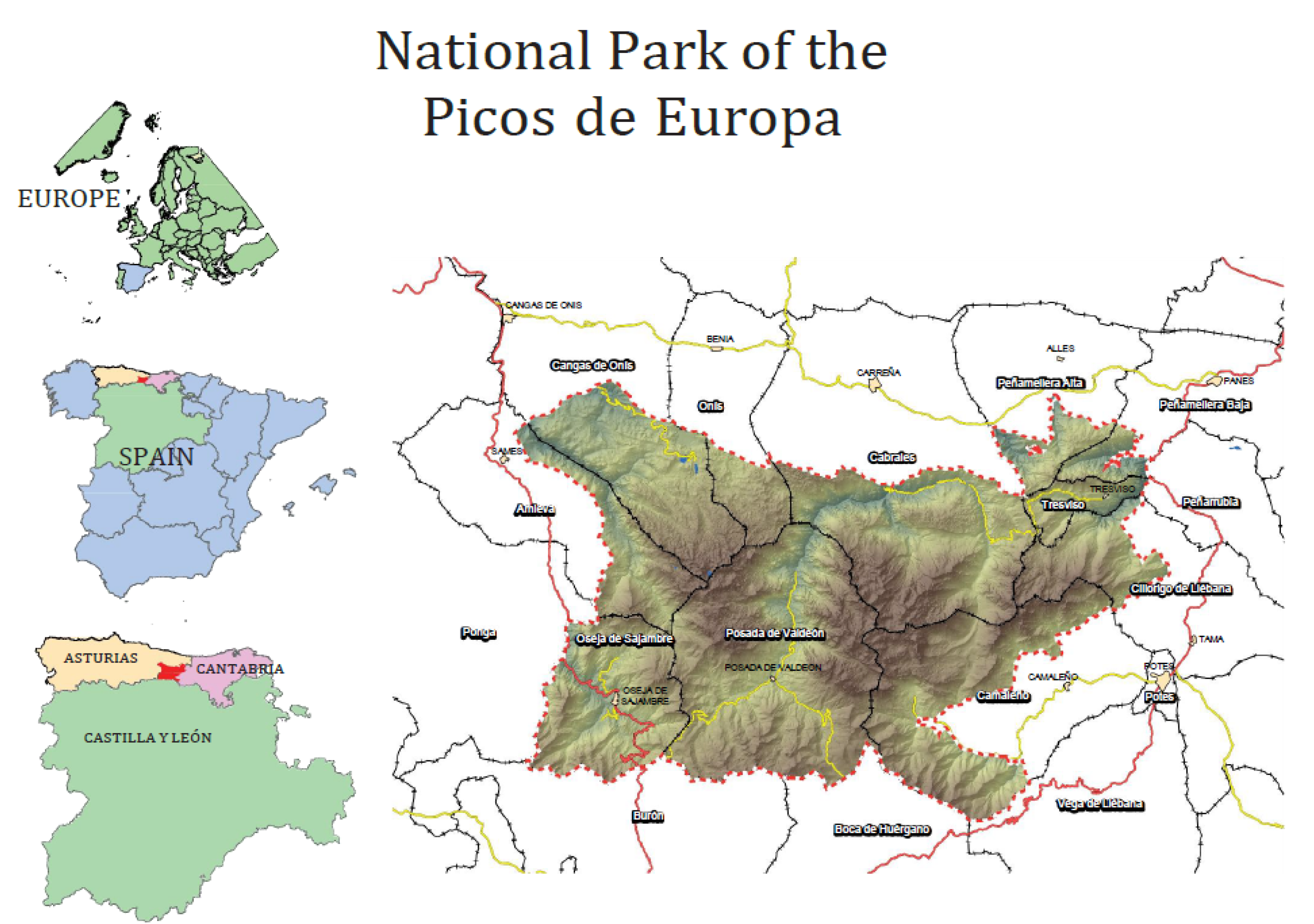
The Physical and Social Setting of the Picos de Europa National Park

The Picos de Europa National Park [23] is located in the north of the Iberian Peninsula, between Asturias, Cantabria, and Castile-Leon (the province of Leon). It extends over three mountains and the north-facing flank of the Cantabria Cordillera Range (where the park’s densest forests are located).
These peaks, formed by limestone rock that surged up from the seabed due to orogenic activity, make up a terrain of high summits alternating with deep gorges and canyons. Hence, in the park, there are 200 elevations of over 2000 m, with differences in relief of more than 2300 m. The limestone has produced interesting karstic processes with slopes of over 1000 m, intense glacier erosion processes, and glacier lakes.
The park has a surface area of 67,455 hectares, making it the second most extensive one in Spain after Sierra Nevada National Park. Its location coordinates are Latitude 43° 18′ 58″ N, 5° 07′ 15″ O; and Longitude 43° 04′ 28″ N, 4° 37′ 03″ O. The National Park was created by Law 16/1995, which was later expanded in 2015. However, as it is heir to the first NP created in Spain, a part of the current park was already officially protected as of 1918 (Montaña de Covadonga National Park), one of Europe’s first as well.
The park has received international recognition for its state of conservation and planning, and for the comprehensive management of its natural resources. Part of its territory is a Biosphere Reserve, Special Area of Conservation (SAC), and Special Protection Area (SPA) for Birds.
The mesotrophic limestone soil and the variability in altitude (almost 2500 m in an area of relatively small size (674.55 km²), as well as the influence from the nearby sea, converge in a wide variety of ecosystems, with an ample diversity of flora: around 1900 species and subspecies, with some taxa specific to the park. The fauna associated with these ecosystems includes such emblematic species as the Cantabrian chamois, the wolf, the woodland grouse, and the brown bear, among others, some in danger of extinction. The unique geomorphological formations have shaped a landscape of great variety and esthetic value. The park encompasses deep canyons carved out by rivers, striking grooves, and gullies that drop down 1500 m or more, beech and oak forests, and the extraordinary mixed Cantabrian forest (in some areas residual Tertiary laurel forest), with meadows that are the result of centuries of human presence and livestock raising. Presiding over it all are the distinctive white limestone cliffs, in a permanent process of change due to the erosive action of water, ice, and wind, creating such unusual formations as the lapiaces (limestone grooves and hollows). Obviously, this variability of ecosystems and the fragility of many of them condition their detailed management and constrain the adoption of any decision that could affect their conservation.
Another unique feature of the park is that it is practically the only Spanish National Park with human populations living within its boundaries. Picos de Europa was occupied very early on in history, with a permanent human presence dating back to at least the Neolithic Period. Currently, the number of people dwelling within the park is approximately 981 (2021), distributed among 11 municipalities.
Its inhabitants have continued to make use of its territory up to the present day, shaping its landscapes to a considerable extent, at least in the less mountainous areas of the park, mainly through raising livestock and small-scale farming, along with wood gathering in the forest cover. In a large part of its extension, Picos de Europe is a humanized park.
In addition, the park’s socioeconomic area of influence is inhabited by 14,164 people (2020) and includes an extension of 133,682.56 hectares pertaining to the 11 municipalities distributed among the three Autonomous Communities of Asturias, Cantabria, and Castile-Leon.
There has been an intense interrelation throughout history between the territory and its human populations, whose manifestations are so evident that a symbiosis seems to have existed between the two elements [23]. Indeed, this remarkable landscape is as much a result of the natural terrain and the morphological composition as it is the human activity that has taken place over centuries in its valleys and around the higher altitude majadas (temporary settlements used during the grazing season in the mountains).
All of this makes it one of the most visited NPs in Spain, with nearly two million visitors a year (1,620,739 visitors in 2021 despite COVID-19 restrictions on mobility), which at the same time presents a challenge for its management.

4. System for Evaluation and Monitoring the Socio-Economic Impact of Global Change in the Picos de Europa National Park

These biophysical and social characteristics of the park make assessing and monitoring the impact of global change an even more urgent task.
As mentioned, in Spain there is a Global Change Monitoring Program in the NP Network [24], dependent on the Ministry of Ecological Transition and Demographic Challenge. The scope of its monitoring is broad; although, it exclusively targets the biophysical environment, concretely in the placement of automatic weather stations (the Picos de Europa National Park has eight installations) along with specific studies on certain species and areas [24]. Analysis aimed at socio-economic monitoring of global change is non-existent, beyond its annual report (number of visitors, livestock using pastures, etc.) and, as noted earlier, the system of indicators for Sierra de Guadarrama and Picos de Europa National Parks [9].
In this context, the objective of this research is to design and operationalize a system for evaluating and monitoring the socio-economic impact of global change for the Picos de Europa National Park. It seeks to respond to the need for a sufficient set of data to monitor the effects of global change in the short, mid, and long term in the social and economic settings of the park. The research focus is on the Picos de Europa National Park due to its distinctive feature of being an inhabited national park, constituting, hence, the most complex case, while at the same time, looking to draw recommendations that can be applied to other national parks.
This general objective has been specified into the following goals:
-
Creating and fine-tuning an updated database for all the indicators of social and economic change that are able to be monitored.
-
Defining a system of indicators for monitoring (and eventually evaluating) global change in the social and economic setting of the Picos de Europa National Park, specifying what can be extrapolated to other national parks with similar features.

5. Theoretical Framework for the Indicators and Justification

The indicators were selected to obtain a balance between the general use of protected natural areas and those developed for the particular case of the Picos de Europa National Park. Utilizing indicators of general use is always helpful, since they allow for comparison between different protected areas. In addition, by incorporating broader monitoring, it is possible to obtain a longer time series.
There are diverse systems of indicators that use different frames of reference. One of them, the most simple, consists of structuring indicators by topic and subtopic so that the results appear grouped together and ordered. Another more structured framework is the ‘Pressure-State-Response’ (PSR) model, which was originally developed and recommended by the OECD [25]. In this model, indicators are first identified for ‘Pressure’, which corresponds to the causes for the phenomena under study (global change in this case). The second is the ‘State’ of the environment receiving the impacts from the pressure, and the third is the ‘Response’ of society to the problems presented. Through this framework of reference, cause–effect relationships are explicit in the monitoring system.
There are other models, such as the one later extended by the OECD—the DPSIR, Driving force-Pressure-State-Impact-Response framework. As Mosaffaie et al. [26] (p. 1) point out, “the DPSIR model depicts ‘why it happened’ through P and D terms. After knowing why it happened, we can and should further analyze ‘how to deal with it’. There are many ways to achieve this goal, either directly through S or I, or acting on P or D”.
For national parks, where there is a lack of disaggregated socio-economic data for the specific park area, the simpler model—PSR—could be more useful as a framework of reference, to provide coherence from a systematic perspective, while at the same time being a more viable model. This is an approach based on the objective of an evaluation and monitoring system, formed as such by a series of interrelated elements from different processes. The indicators should be variables (or indexes) that provide information about the trends of change in these elements and processes and that explain the global functioning of the system and its deviation from or its approximation to greater sustainability. Pressure indicators (global change) are beyond the scope of this study, as a planetary process is scarcely affected by the activities taking place in the park, and the focus of our system of indicators is on impact and adaptation.
The first block of indicators is the frame of reference on the STATE of the situation in the PSR model; hence, it is called the ‘Receptor environment’ (RE) in this study. The variation in its indicators, as a result of the pressure due to global environmental change and that of the mitigation and adaptation measures, is what will reflect the social and economic impacts of global change. The impact can be evaluated once the monitoring system is developed, along with its evolution over time. Specifically, the following categories in the levels of differentiation for group and subgroup (in parenthesis) are included in the system of socio-economic indicators:
-
Natural resources (land use: water consumption; water treated by the purification system; energy consumption; agricultural resources, environmental resources; waste treatment).
-
Demographic base (population and characteristics; activity, occupation; unemployment).
-
Economic base (production of goods and services; employment in productive activities; tourism activity; income and transfer; public investments).
-
Social, political, and cultural base (health; political and social organization; social cohesion; well-being; poverty; security; culture).
The second frame of reference corresponds to RESPONSE in the scheme, called ‘Mitigation and Adaptation’ (M&A), which includes two levels of group differentiation and others for the subgroup (in parenthesis):
-
Governance (official; unofficial; national park management; legislation).
-
Social and research instruments (information and communication; perception; education; training and participation; socio-economic research).
This is the framework of reference that defines the selection of indicators for this project.

6. Materials and Methods

The area of study entails the eleven municipalities where the Picos de Europa National Park is located along with its socio-economic area of influence, as it is defined legally [27] (Figure 1).
The methodology used has been quantitative and qualitative in a combined way [28]. The materials and methods utilized are the following:
(1)
Bibliographic search and analysis, including academic databases and public administration reports. Given the nature of the Spanish National Parks, in addition to scientific literature, it is necessary to examine studies and documentation from public administrations and responsible agencies [29], as well as from other similar experiences in other national parks. Although each park has its own distinctive features, all of them have their objective of conservation and their complex management in common. Thus, there are many elements that are highly useful for comparison and learning purposes.
(2)
Collecting and analyzing national, regional, and local legislation, and programs and plans affecting the park as well as specific park legislation and planning. The foregoing must be taken into account as they represent the context that will determine the characteristics for this system of indicators.
(3)
Collecting and analyzing the statistical information necessary to create a database for monitoring purposes for the short, mid, and long term, distinguishing between official sources and other reliable sources from grey literature [29]. This combination of information will not only allow data to be compared and contrasted, but most importantly, lead to critical analysis.
(4)
Holding a workshop with academic experts and specialists in national park management, aimed at discussion and consensus regarding the focus for a system of indicators of this nature, inexistent in the other Spanish National Parks. Specifically, a workshop was held with eight participants chosen from different fields of study, including Sociology and Economics, and from National Park management. This interdisciplinary academic and management focus has enriched the proposed approaches by combining scientific knowledge with the empirical knowledge of day-to-day management [30].
(5)
Designing and developing indicators for state, impact, and response. The indicators contain current information (chiefly, although not limited to, statistical data) but also reveal the deficits and shortcomings to resolve in future monitoring. This design was corroborated by park managers for several reasons: much of the required information came necessarily from the managing institution; their empirical experience added a greater degree of practicality to the indicators selected.
(6)
Identifying the interrelations between indicators. This is key in creating a system of indicators, and not simply drawing up a lengthy list [31]. This is one of the most complex tasks, since global change is a multidimensional issue with impacts that are likewise multidimensional. Our research presents some of these interrelations, as a hypothesis that will need to be revised over time for adaptive monitoring [32].

Methodological Conceptualization

To achieve these objectives, the starting point must be a conceptualization that allows us to orient the scope and content of the indicators to select.
Hutto and Belote [33] (p. 1) point out that the type of monitoring to be performed will differ according to the questions previously posed. They establish four types of monitoring—surveillance, implementation, effectiveness, and ecological effects “that are designed to answer very different questions and achieve very different goals. Surveillance monitoring is designed to uncover changes in target variables over space and time; implementation monitoring is designed to record whether management actions were applied as prescribed; effectiveness monitoring is designed to evaluate whether a given management action was effective in meeting a stated management objective; and ecological effects monitoring is designed to uncover unintended ecological consequences of management actions”.
The research presented here represents the first type, surveillance; although, in some ways, it takes into account the second type, implementation, since it includes indicators not only on the state, but also on impacts, mitigation, and adaptation. However, for this same type, the differentiation made by Hellawell [34] is pertinent, as this author noted that monitoring could only be referred to when trying to determine the degree of deviation of the indicator values from the reference values established beforehand. When the indicator value is not compared with the reference value, the indicator acts as a type of surveillance.
Therefore, monitoring should not be referred to when doing only a diagnostic evaluation, that is to say, evaluating the state of a system or some of its components at a moment in time. However, if repetition of this diagnostic assessment were set up, as is the case of this system of indicators, it would be close to the concept of monitoring, establishing reference thresholds to compare the evolution of the system with the initial state.
Designing a system of evaluation and monitoring, as is the goal of this study, is to operationalize an observation process repeated in space and time of the variables to be studied, which requires establishing methods to obtain comparable data.
It is necessary to define the objectives of the evaluation and monitoring system before identifying the set of indicators for the system and make it possible to detect changes in their processes, establishing continuation of protocols to measure these indicators.
As the theoretical basis and method for defining indicators can be common to the socio-economic system and to the bio-geophysical ecosystems and landscapes (which are the result of the interrelation between the bio-geophysical and the social environment), when identifying the objectives of the evaluation and monitoring process it is possible to generically refer to the systems under study, with the understanding that they can be either natural or social.
For the case of evaluating and monitoring the socio-economic impact of global change on the Picos de Europa National Park, the specific objectives for the indicators have been defined as follows:
-
To record the dynamics of the systems under study, analyzing the trends of change, whether due to natural or social (anthropic) causes.
-
To improve knowledge about the systems studied, through the collection or generation of new information related to the social and economic impact of global change on the park.
-
To predict specific and/or global changes in the systems studied, especially alterations or damage from unforeseen events.
-
To identify effects on the dynamics of social systems resulting from management practices, and to detect undesired effects.
Indicators are the instruments that support any evaluation or monitoring system. Although there are many definitions for the concept of indicators for natural protected areas, for this study, they are understood as a variable or the relationship between variables (indexes) whose measurement can reveal certain references about the evolution of the system in which they are immersed. The variables and indexes that have this indicator characteristic are those that are sensitive to changes and trends of a natural or human origin.
The indicators must be significant and meaningful, in this case, from the point of view of sustainability [35]. Social and economic variables lacking meaning or significance linked to sustainable development will be less useful as indicators in this system. As such, the evaluation and monitoring system should never be understood as a mere list of indicators, but rather always in its connection with the goal of sustainable development, as posed by Agenda 2030 [36], to which Spain has subscribed.
Clearly, the highly complex interlinked natural and social systems in protected natural areas make it virtually unfeasible to measure all possible indicators. A limited selection is thereby needed in order to maximize information and minimize cost.
A first filter to reduce the initial list could be verifying if the preselected indicators satisfy certain basic requisites. These could include, in addition to their rigor and reliability, that they are sufficiently sensitive so as to provide early warning about change; be able to be distributed over a large geographical area or be easy to apply; be capable of providing continuous estimates under a wide range of stress; be relatively independent of the sample size; be easy to measure or interpret; be easy to differentiate between natural cycles and changes brought about by anthropogenic influence; and be relevant to important socioeconomic and ecological phenomena (global and climate change in this case).
Finally, the indicators were selected to obtain a balance between the general use of protected natural areas and those developed for the particular case of the Picos de Europa National Park. Utilizing indicators of general use is always helpful, since they allow for comparison between different protected areas. In addition, by incorporating broader monitoring, it is possible to obtain a longer time series.
For gathering data for the set of indicators, only published statistical sources have been used. These include the Municipal Register of Inhabitants; the Population and Housing Census; the Economic and Social Data Report from the Territorial Units of Spain (Caja España-Caja Duero); the Institute of Statistics from the Autonomous Communities; the Public Employment Service; the Ministry of the Interior; Ecoembes and Ecovidrio; the Ministry of the Economy and Competitiveness; annual reports from the Picos de Europa National Park (visitor statistics, natural resources databases, investments, management actions, etc.); and the National Institute of Statistics.
For a detailed description of each municipality in the Picos de Europa National Park, a data sheet has been drawn up for every one of them with their main socio-economic characteristics (Table 1). Thus, each municipality has its own data sheet according to the following areas and sections.
Territorial data include figures on the total population of the municipality, population density, surface area forming part of the park, and distance from the municipality to the capital of the province of the Autonomous Community.
The section on population and demography synthesizes the evolution of the population (gender and year-on-year growth rate), the structure and movement of the population (population pyramid, demographic dependency ratio, rate of aging, trends, and replacement rate), as well as the immigrant population (by gender and evolution).
Information on the productive structure of the municipalities in the park includes the economic and productive sector (number of workers and companies by activity sector or land use), services and tourism activities (commercial establishments, tourist capacity, and basic facilities), employment and unemployment (evolution of the unemployment rate), and housing (type of housing and type of ownership for principal dwellings).
Living conditions in the park municipalities include data on educational facilities (non-university educational centers), healthcare facilities (primary healthcare centers, clinics, and pharmacies), motorization (registered vehicles), and associations, sports entities, and other collectives located within the administrative limits.
The section on environmental information refers here to selective waste collection (plastics and containers, paper and cardboard, and glass).
The data sheet also includes data on municipal budgets (municipal financial expenditures and real expenses)—there are no published data on income—and voter participation (abstention in local elections).
In short, these data sheets provide a general overview of the socio-economic situation and evolution for each municipality located within the Picos de Europa National Park.

7. Results

A data sheet (Annex Table 2) has been elaborated with information for each of the indicators. The indicators developed (Table 3) vary in detail for diverse reasons, among which is the lack of disaggregated statistical information for the park area; this has been the case, for example, for the indicators on the estimation of income generated by private individuals and by companies.

8. Discussion

This pilot model for the System of Indicators for the Socio-Economic Evaluation and Monitoring of Global Change for the Picos de Europa National Park has been designed to take into account its utility not only for the park itself, but for other national parks as well. Thus, among its contributions is minimizing the lack of homogenization in indicators for monitoring global change and climate change in Spain [24] and in other protected areas throughout the world [37].
Despite the foregoing, it should be taken into account that this System of Indicators is designed based on the specific reality of the Picos de Europa National Park, and on its evolution and unique features. Accordingly, it is always necessary to adapt it to each park’s bio-geophysical and socio-economic characteristics.
Therefore, park management and the development of indicators in the context of global and climate change must incorporate human beings as part of the protected space and accordingly safeguard them as well [20]. This human factor has a two-fold facet for its potential impact on the natural setting and for playing a key role in the park protection and conservation [23]. This is in line with the results of the analysis [38] of indicators from 180 countries, which revealed limited diversity and representation of important well-being dimensions such as health and governance.
Nevertheless, including social factors in the management of protected areas, such as national parks, [39] can lead to doubts about the weight given to protection with respect to the economic development of the zone. Accordingly, Hummel [39] (p. 1) calls for “a balanced and inclusive combination of the societal-focussed approach and the traditional view of conservation, protecting nature, and biodiversity, in order to become adopted in current management strategies.” However, difficulties abound in the social factors that are to be taken into account, and how they are considered, as is the case for commitment to equitably management of protected areas assumed by 194 countries worldwide in the Aichi Target 11, Convention, whose results are not comparable across sites [38]. This is because among other reasons, no adequate standardized metrics to assess equitably management exists [40].
At the same time, as it is a protected area managed by three public regional administrations with different political criteria, Picos de Europa co-management, government, and governance all require special attention, due to the obstacles and difficulties entailed [41], while taking advantage of opportunities presented for understanding and cooperation. The co-management of protected areas in virtually all parts of the world, whether the responsibility of various public administrations or through the intervention of other social actors, is an issue of political and scientific relevance still requiring further theoretical and empirical knowledge so that it can be improved [42].
Hence, there are indicators that are especially relevant. This is the case for public participation, which includes information, communication, training, and tracking the social perception of global and climate change in national parks; that is, the social instruments of environmental management, which are still limited in their application to the management of protected areas [43].
Indicators on tourism are also especially important, given that there are almost two million visitors a year in the Picos de Europa National Park. There is a risk of negative impact on this protected area if this tourism is not sufficiently limited and controlled [44]. Nevertheless, tourism has the potential to be used for increasing social awareness about the importance of sustainable development for the national parks and all types of protected natural areas, and advantage can even be taken from income generated by tourism by reinvesting it in park sustainability policies [44,45]. Both indicators have been included in this system of indicators; although, they require strict monitoring.
At the same time, this system can be a reference for the design of other models in other protected areas, considering the aforementioned lack of both empirical and theoretical knowledge on socio-economic indicators of global change. This would mean including some social indicators in the system that are rarely examined for national parks, such as the social and political base, governance, political and social organization, well-being, poverty, culture, and people’s social perception [10].
Adaptation of this System of Indicators as such would require previous research into each park, and thus, an ad hoc study. In any case, further work is needed on this model, especially for its empirical testing, in order to improve it for future editions.
However, above all, as pointed out by Peterson et al. [46] (p. 1) in their review of the knowledge on climate change adaptation in national forests, “adaptation to climate change will be successful only if it can be fully implemented in established planning processes and other operational aspects of national forest management”. A critical gap still remains between the synthesis of scientific information on climate change vulnerability and adaptation and the actual integration of these ideas into management plans and practices [47]. This is a task that has not yet been carried out in either of the two national parks in Spain for which the system of indicators monitoring climate change has been developed. Nor has it been undertaken in the majority of national parks worldwide [3]. This represents a significant limitation in determining the effectiveness of a system of indicators and the feedback required.

9. Conclusions

The first relevant conclusion is that, as the literature review revealed, there is still very limited research into the socioeconomic impact of global change on national parks. However, taking into account the grave nature of this issue, its assessment and monitoring, in this case of the socioeconomic environment, is a key activity in the fight against global change and in particular climate change.
Despite the advancement in knowledge regarding this problem, designing a system of indicators as proposed here presents numerous difficulties. These include the still insufficient disaggregated quantitative and qualitative information on the national parks; the complexity of interpreting the socioecological processes that are produced within them, and of those, the pressure of global change and climate change in particular; and the continuity in monitoring necessary to obtain sufficient time-series data. The aforementioned factors have been the main limitations in the development of this project.
Nevertheless, the system of socio-economic indicators presented in this paper provides a framework for monitoring and interpreting changes in the Picos of Europe National Park, which admittedly need to be improved over time, according to the results and data viability. The approach taken here could also be applied in other similar national parks and be useful for their management.

Author Contributions

Conceptualization, I.L. and R.S.; methodology, I.L. and M.P.; investigation, I.L., R.S. and M.P.; writing—original draft preparation, I.L.; writing—review and editing, M.P.; funding acquisition, I.L. and M.P. All authors have read and agreed to the published version of the manuscript.

Funding

This research was funded by Fundación Biodiversidad 2010/00171/001. No funds were received to cover the costs of publishing in open access.

Informed Consent Statement

Not applicable.

Data Availability Statement

Conflicts of Interest

The authors declare no conflict of interest.

References

  1. IPCC. Summary for Policymakers. In Climate Change 2021: The Physical Science Basis. Contribution of Working Group I to the Sixth Assessment Report of the Intergovernmental Panel on Climate Change; Masson-Delmotte, V.P., Zhai, A., Pirani, S.L., Connors, C., Péan, S., Berger, N., Caud, Y., Chen, L., Goldfarb, M.I., Gomis, M., et al., Eds.; Cambridge University Press: Cambridge, UK, 2021; in press. [Google Scholar]
  2. Future Earth. Sustainability in the Digital Age, and International Science Council. Global Risks Perceptions Report 2021; Future Earth Canada Hub. Available online: https://doi.org/10.5281/zenodo.5764288 (accessed on 1 September 2021).
  3. Baron, J.S.; Allen, C.D.; Fleishman, E.; Gunderson, L.; McKenzie, D.; Meyerson, L.; Stephenson, N. National parks. In Adaptation Options for Climate-Sensitive Ecosystems and Resources; The US Climate Change Science Program: Washington, DC, USA, 2008. [Google Scholar]
  4. Franz, H.; Vogel, M. National Parks as outdoor laboratories for climate change impact. In Proceedings of the European Conference Climate Change and Nature Conservation in Europe—An Ecological, Policy and Economic Perspective, Bonn, Germany, 25–27 June 2013; p. 87. [Google Scholar]
  5. Zamora, R.; Pérez-Luque, A.J.; Bonet, F.J. Monitoring global change in high mountains. In High Mountain Conservation in a Changing World; Catalan, J., Ninot, J., Aniz, M., Eds.; Springer: Berlin/Heidelberg, Germany, 2017; pp. 385–413. [Google Scholar]
  6. Machlis, G.E.; Tichnell, D.L.; Eidsvik, H.K. The State of the World’s Parks: An International Assessment for Resource Management, Policy, and Research; Routledge: London, UK, 2019. [Google Scholar]
  7. Berkes, F.; Folke, C.; Colding, J. (Eds.) Linking Social and Ecological Systems: Management Practices and Social Mechanisms for Building Resilience; Cambridge University Press: Cambridge, UK, 2000. [Google Scholar]
  8. López, I.; Pardo, M. Socioeconomic indicators for the evaluation and monitoring of climate change in national parks: An analysis of the Sierra de Guadarrama National Park (Spain). Environments 2018, 5, 25. [Google Scholar] [CrossRef] [Green Version]
  9. López, I.; Pardo, M. Tourism versus nature conservation: Reconciliation of common interests and objectives—An analysis through Picos de Europa National Park. J. Mt. Sci. 2018, 15, 2505–2516. [Google Scholar] [CrossRef]
  10. Corrigan, C.; Robinson, C.J.; Burgess, B.D.; Kingston, N.; Hockings, M. Global review of social indicators used in protected area management evaluation. Conserv. Lett. 2018, 11, e12397. [Google Scholar] [CrossRef] [Green Version]
  11. Loveridge, R.; Sallu, S.M.; Pesha, I.J.; Marshall, A.R. Measuring human wellbeing: A protocol for selecting local indicators. Environ. Sci. Policy 2020, 114, 461–469. [Google Scholar] [CrossRef]
  12. Callaghan, M.W.; Minx, J.C.; Forster, P.M. A topography of climate change research. Nat. Clim. Change 2020, 10, 118–123. [Google Scholar] [CrossRef]
  13. Carter, R.W.; Walsh, S.J.; Jacobson, C.; Miller, M.L. Global change and human impact challenges in managing iconic national parks. Georg. Wright Forum 2014, 31, 245–255. [Google Scholar]
  14. Miller, M.L.; Carter, R.W.; Walsh, S.J.; Peake, S. A conceptual framework for studying global change, tourism, and the sustainability of iconic national parks. Georg. Wright Forum 2014, 31, 256–269. [Google Scholar]
  15. Duarte, C.M.; Alonso, S.; Benito, G.; Dachs, J.; Montes, C.; Pardo Buendía, M.; Valladares, F. Cambio Global. Impacto de la Actividad Humana Sobre el Sistema Tierra; CSIC: Madrid, Spain, 2006.
  16. Palomo, I. Climate change impacts on ecosystem services in high mountain areas: A literature review. Mt. Res. Dev. 2017, 37, 179–187. [Google Scholar] [CrossRef] [Green Version]
  17. Martin-Lopez, B.; Leister, I.; Lorenzo Cruz, P.; Palomo, I.; Grêt-Regamey, A.; Harrison, P.A.; Walz, A. Nature’s contributions to people in mountains: A review. PLoS ONE 2019, 14, e0217847. [Google Scholar] [CrossRef] [Green Version]
  18. Durán, M.; Canals, R.M.; Sáez, J.L.; Ferrer, V.; Lera-López, F. Disruption of traditional land use regimes causes an economic loss of provisioning services in high-mountain grasslands. Ecosyst. Serv. 2020, 46, 101200. [Google Scholar] [CrossRef]
  19. Hugo, M.; Carvalho, P.; Almeida, N. Destination Brand Experience: A Study Case in Touristic Context of the Peneda-Gerês National Park. Sustainability 2021, 13, 11569. [Google Scholar]
  20. Funnell, D.; Parish, R. Mountain Environments and Communities; Routledge: London, UK, 2005. [Google Scholar]
  21. MITECO. Red de Parques Nacionales. Seguimiento y Evaluación—Seguimiento Sociológico. Available online: https://www.miteco.gob.es/es/parques-nacionales-oapn/plan-seguimiento-evaluacion/sociologico.aspx (accessed on 15 September 2021).
  22. MITECO. Red de Parques Nacionales. Características de los Parques Nacionales. Available online: https://www.miteco.gob.es/es/red-parques-nacionales/red-seguimiento/rscg.aspx (accessed on 15 September 2021).
  23. PNPE—Parque Nacional Picos de Europa. Presentación. Available online: https://parquenacionalpicoseuropa.es/el-parque/presentacion/ (accessed on 1 September 2021).
  24. MITECO. Red de Seguimiento del Cambio Global en la Red de Parques Nacionales. Available online: https://www.miteco.gob.es/es/red-parques-nacionales/red-seguimiento/rscg.aspx (accessed on 1 September 2021).
  25. OECD. Environmental Indicators. OECD Core Sets; OECD: Paris, France, 1994.
  26. Mosaffaie, J.; Jam, A.S.; Tabatabaei, M.R.; Kousari, M.R. Trend assessment of the watershed health based on DPSIR framework. Land Use Policy 2021, 100, 104911. [Google Scholar] [CrossRef]
  27. MITECO. Parque Nacional Picos de Europa. Area de Influencia Socioeconómica. Available online: https://www.miteco.gob.es/es/red-parques-nacionales/nuestros-parques/picos-europa/area-influencia/default.aspx (accessed on 1 September 2021).
  28. Bryman, A. Social Research Methods; Oxford University Press: Oxford, UK, 2016. [Google Scholar]
  29. Paez, A. Gray literature: An important resource in systematic reviews. J. Evid. Based Med. 2017, 10, 233–240. [Google Scholar] [CrossRef]
  30. Nelson, E.; Mathieu, E.; Thomas, J.; Harrop Archibald, H.; Ta, H.; Scarlett, D.; Tambalo, D. Parks Canada’s adaptation framework and workshop approach: Lessons learned across a diverse series of adaptation workshops. Parks Steward. Forum 2021, 36, 1. [Google Scholar] [CrossRef] [Green Version]
  31. Diamantopoulos, A.; Winklhofer, H.M. Index construction with formative indicators: An alternative to scale development. J. Mark. Res. 2001, 38, 269–277. [Google Scholar] [CrossRef]
  32. Lindenmayer, D.B.; Likens, G.E. Adaptive monitoring: A new paradigm for long-term research and monitoring. Trends Ecol. Evol. 2009, 24, 482–486. [Google Scholar] [CrossRef]
  33. Hutto, R.L.; Belote, R.T. Distinguishing four types of monitoring based on the questions they address. For. Ecol. Manag. 2013, 289, 183–189. [Google Scholar] [CrossRef]
  34. Hellawell, J.M. Development of a rationale objective for monitoring. In Monitoring for Conservation and Ecology; Goldsmith, F.B., Ed.; Chapman and Hall: London, UK, 1991; pp. 1–14. [Google Scholar]
  35. Dudley, N.; Ali, N.; Kettunen, M.; MacKinnon, K. Editorial essay: Protected areas and the sustainable development goals. Parks 2017, 23, 10–12. [Google Scholar] [CrossRef]
  36. UN. Transforming Our World: The 2030 Agenda for Sustainable Development; UN: New York, NY, USA, 2015.
  37. Hill, S.L.; Harfoot, M.; Purvis, A.; Purves, D.W.; Collen, B.; Newbold, T.; Mace, G.M. Reconciling biodiversity indicators to guide understanding and action. Conserv. Lett. 2016, 9, 405–412. [Google Scholar] [CrossRef] [Green Version]
  38. Moreaux, C.; Zafra-Calvo, N.; Vansteelant, N.G.; Wicander, S.; Burgess, N.D. Can existing assessment tools be used to track equity in protected area management under Aichi Target 11? Biol. Conserv. 2018, 224, 242–247. [Google Scholar] [CrossRef]
  39. Hummel, C.; Poursanidis, D.; Orenstein, D.; Elliott, M.; Adamescu, M.C.; Cazacu, C.; Hummel, H. Protected Area management: Fusion and confusion with the ecosystem services approach. Sci. Total Environ. 2019, 651, 2432–2443. [Google Scholar] [CrossRef]
  40. Zafra-Calvo, N.; Pascual, U.; Brockington, D.; Coolsaet, B.; Cortes-Vazquez, J.A.; Gross-Camp, N.; Burgess, N.D. Towards an indicator system to assess equitable management in protected areas. Biol. Conserv. 2017, 211, 134–141. [Google Scholar] [CrossRef] [Green Version]
  41. Fabricius, C.; Collins, S. Community-based natural resource management: Governing the commons. Water Policy 2007, 9, 83–97. [Google Scholar] [CrossRef]
  42. Soliku, O.; Schraml, U. Making sense of protected area conflicts and management approaches: A review of causes, contexts and conflict management strategies. Biol. Conserv. 2018, 222, 136–145. [Google Scholar] [CrossRef]
  43. Nita, A.; Ciocanea, C.M.; Manolache, S.; Rozylowicz, L. A network approach for understanding opportunities and barriers to efftive public participation in the management of protected areas. Soc. Netw. Anal. Min. 2018, 8, 1–11. [Google Scholar] [CrossRef]
  44. Leung, Y.F.; Spenceley, A.; Hvenegaard, G.; Buckley, R. Tourism and Visitor Management in Protected Areas: Guidelines for Sustainability; IUCN: Gland, Switzerland, 2018. [Google Scholar]
  45. Dharmaratne, G.S.; Sang, F.Y.; Walling, L.J. Tourism potentials for financing protected areas. Ann. Tour. Res. 2000, 27, 590–610. [Google Scholar] [CrossRef]
  46. Peterson, D.L.; Millar, C.I.; Joyce, L.A.; Furniss, M.J.; Halofsky, J.E.; Neilson, R.P.; Morelli, T.L. Responding to Climate Change in National Forests: A Guidebook for Developing Adaptation Options; Gen. Tech. Rep. PNW-GTR-855; US Department of Agriculture, Forest Service, Pacific Northwest Research Station: Portland, OR, USA, 2011. [Google Scholar]
  47. Carlton, J.S.; Angel, J.R.; Fei, S.; Huber, M.; Koontz, T.M.; MacGowan, B.J.; Prokopy, L.S. State service foresters’ attitudes toward using climate and weather information when advising forest landowners. J. For. 2014, 112, 9–14. [Google Scholar] [CrossRef] [Green Version]
Figure 1. Location of the Picos de Europa National Park. Source:PNPE.
Land 11 00741 g001
Table 1. Data sheet municipalities.
AreaSections
01.
Territorial data
-
Total population
-
Population density
-
Area included in the park
-
Distance to the capital of the province
02.
Population and demography
-
Population evolution
-
Structure and movement
-
Immigrants
03.
Productive structure
-
Economy and productive sectors
-
Services and tourist activity
-
Employment and unemployment
-
Housing
04.
Living conditions
-
Facilities
-
Motorization
-
Associations present
05.
Environment
-
Waste
06.
Municipal income and budget
-
Municipal budget
07.
Participation in elections
-
Voter participation
Source: own elaboration.
Table 2. Example of Indicator data sheet of each indicator.
System of Indicators for Socio-Economic Evaluation and Monitoring of Global Change for the Picos de Europa National Park
Indicator Data Sheet
Indicator NameAgriculture and Livestock Area Index
Frame of ReferenceReceptor environmentReference number
MR-02
Group of indicatorsNatural resources
SubgroupLand use
CHARACTERISTICS OF SELECTED INDICATOR
Objective, definition, and justification of the indicatorThe agricultural and livestock exploitations within the territory, which include the strata of agricultural crops, scrub, pasture, and grassland. It seeks to reflect land use by those that do not entail an irreversible transformation of the National Park.
Measurement parametersPercentage of agricultural and livestock area with respect to the total park area.
Calculation formulaAgricultural area multiplied by 100, divided by the total area.
Unit of measurementPercentage rate, result of dividing hectares by hectares.
Data disaggregationBy park municipalities.
Source of informationNational Forest Inventory.
ScopeThe territory included within the delimitation of the National Park.
Data availabilityUpon request from the National Park Management Office.
Measurement periodicityCorresponding to the update from the National Forest Inventory.
Responsibility for the accuracy of dataMinistry of Ecological Transition and Demographic Challenge (current name)
Indicators to which it is relatedRE-01, RE-02, RE-04. (Table 3)
Reference valuesOther National Parks.
INDICATOR VALUES FOR THE DIFFERENT AREAS AND PERIODS
YearMunicipalities of the NP in AsturiasMunicipalities of the NP in Cantabria & Castile-LeonTotal municipalities of the NP
(*) Comments
(*) Values above 100 imply the predominance of agricultural use of the territory, which is almost exclusively livestock raising since there are few agricultural uses. Source: own elaboration.
Table 3. Indicators for the Socio-Economic Monitoring and Evaluation System of Climate Change for the Picos de Europa National Park.
Receptor Environment Indicators (RE)
Indicator NameRelated Indicators (A Hypothesis That Must be Empirically Tested in the Future)
RE-01Wooded forest indexRE-02, RE-03, RE-04
RE-02Agricultural and livestock area indexRE-01, RE-03, RE-04
RE-03Agriculture and livestock forest indexRE-01, RE-02-RE-04
RE-04Scrubland indexRE-01, RE-02-RE-03
RE-05Livestock useRE-06
RE-06Cattle, goats, and sheep RE-05
RE-07Water consumption from the supply networkRE-08
RE-08 Water treated by purification systemsRE-07
RE-09Energy consumptionRE-10
RE-10Energy productionRE-09
RE-11Electrical energy balanceRE-09, RE-10
RE-12Gasoline consumptionR-13
RE-13Diesel consumptionRE-12
RE-14Urban wasteRE-15, RE-16, RE-17, RE-18
RE-15Waste paper collected to recycleRE-14, RE-16, RE-17, RE-18
RE-16Cans and plastic collected to recycleRE-14, RE-15, RE-17, RE-18
RE-17Glass collected to recycleRE-14, RE-15, RE-16, RE-18
RE-18Waste selection containersRE-14, RE-15, RE-16, RE-17
RE-19Demographic population pyramid RE-20, RE-21, RE-22
RE-20Demographic dependency rateRE-19, RE-21
RE-21Aging rateRE-19, RE-20
RE-22Immigration rateRE-19, RE-20, RE-21, RE-23, RE-24, RE-25, RE-26
RE-23Active population rateRE-24, RE-19
RE-24Occupied population rateRE-23, RE-25
RE-25Registered unemploymentRE-19, RE-23
RE-26Agrarian workers rateRE-19, RE-27
RE-27Service economy rateRE-26
RE-28Tourist accommodation capacityRE-29, RE-32
RE-29Park visitsRE-28
RE-30Visitor to resident ratioRE-19, RE-29
RE-31Seasonality of park visitsRE-28, RE-29
RE-32Secondary uses of housing for tourismRE-28, RE-29, RE-30
RE-33Public investment per capitaRE-25, RE-26
RE-34Municipal investment per capitaRE-35, RE-29
RE-35Municipal indebtedness per capitaRE-34, RE-29
RE-36University graduate rateRE-19
RE-37Health infrastructure ratioRE-19, RE-29, RE-33, RE-34
RE-38Home equipment (heating)RE-21, RE-39
RE-39Elderly population living aloneRE-19, RE-21
Mitigation and Adaptation (M&A)
M&A-01Meetings held by the governing and social participatory bodiesM&A-02
M&A-02
M&A-03
Social participation agreements
Legislation
M&A-01
To all the M&A indicators
M&A-04Legislation complianceM&A-03, M&A-05
M&A-05Current agreements with institutionsM&A-03, M&A-04
M&A-06Administrative sanctionsM&A-07
M&A-07Administrative authorizationsM&A-06
M&A-08Non-regulated governance activitiesM&A-01, M&A-05
M&A-09Cleared area for fire protection and improvement of grazing useM&A-10
M&A-10Area for controlled burning to prevent fires and improve grazing
Use
M&A-09
M&A-11Wolf damage to livestockM&A-12, M&A-03, M&A-04, M&A-07
M&A-12Wild boar damage to the productive capacity of grasslandsM&A-03, M&A-07
M&A-13Participants in the environmental education programM&A-14, M&A-28, M&A-29, M&A-32
M&A-14Participants in the park’s volunteer programM&A-13, M&A-28, M&A-32
M&A-15Waste removed from the parkM&A-18
M&A-16Incidence of forest firesM&A -17
M&A-17Investment in prevention and extinction of forest firesM&A-16, M&A-18
M&A-18Public investments in the parkM&A-16, M&A-17, M&A-19
M&A-19Subsidies in the municipalities of the parkM&A-05, M&A-18
M&A-20Compensation for cessation of activity compatible with the parkM&A-19
M&A-21People served at visitor centersM&A-22, M&A-23
M&A-22People served at the information pointsM&A-21
M&A-23School group visits to the parkM&A-24, M&A-25
M&A-24Non-school group visits to the parkM&A23, M&A-25
M&A-25Visitors on guided tours of the parkM&A-24, M&A-23
M&A-26Informative brochures published by the parkM&A-27
M&A-27Specific publications related to Global Change edited by the parkM&A-26
M&A-28Social Perception of Global ChangeM&A-13, M&A-14, M&A-29, M&A-32
M&A-29Training actions on global changeM&A-13, M&A-14, M&A-28, M&A-32
M&A-30Research on the impact of Global Change on the physical environment of the parkM&A-31
M&A-31Research on the impact of Global Change on the socioeconomic of the parkM&A-30
Source: own elaboration.
Publisher’s Note: MDPI stays neutral with regard to jurisdictional claims in published maps and institutional affiliations.

