1. Introduction
1.1. Context: Positive and Negative Valuation of Streetscapes
Many of the new building complexes of the past few years in Zurich are considered by the media [
1,
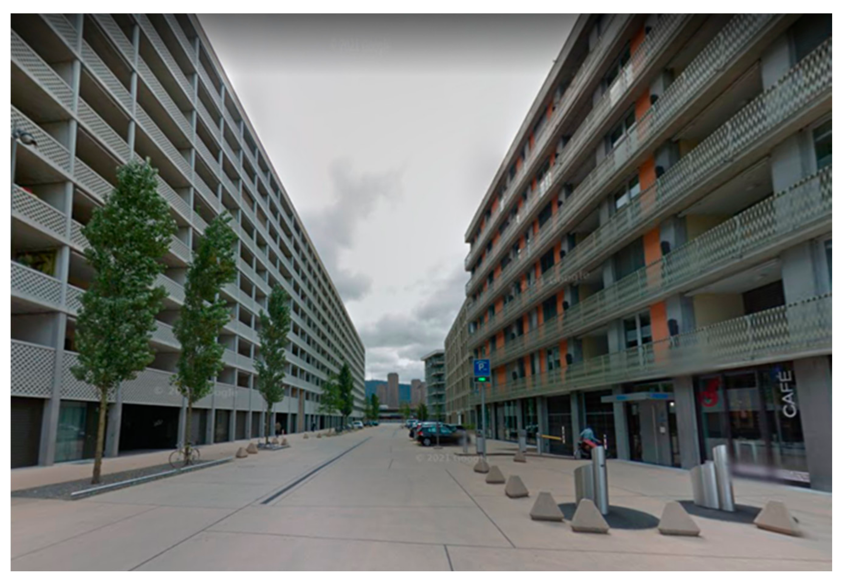
2] and the author’s own assessment to be monotonous and uniform. Three spatial characteristics of these developments seem to be of central cause for this: the repetition of the same façade design along a building front, the repetition of the same façades across multiple buildings, as well as the sheer length of individual façades. One example of this development is the area around the Maaghof in Zurich-West (
Figure 1). The façade of the building, designed by architects Diener and Diener and completed in 2015, measures 140 m.
Huge buildings with long and repetitive facades are a central reason that streetscapes have lost their relation to the human scale. Concerns for this circumstance have not only been voiced recently by the authors and public voices but have already been discussed by people dealing practically and theoretically with the question of the design of our built-up environment. For example, Gehl [
3], Cullen [
4] and Alexander et al. [
5]—all proponents of human-scaled cities—worked on this topic. The human scale can be defined in multiple ways based on building dimensions, both vertically and horizontally, in relation to the speed of human movements or as a function of the capability for social interaction and the possibility for the stimulation of our human senses [
6]. Gehl [
3] takes up all these elements and describes “human scale” through different approximated urban proportions; these include short façade length in order to stimulate pedestrians with many different stimuli, buildings with no more than five stories in order not to unnecessarily strain our natural body posture, as well as guarantee social interaction from the ground to all the floors and maximal measures for average squares of 100 m, which he sees as a natural limit of our eyesight to still recognise people and keep the overview over a space. Different researchers and designers have chosen slightly different numbers to describe these characteristics, but in essence, as Gehl [
3] says, it is about the creation of attractive public spaces for human beings moving on foot. In his book “The Concise Townscape”, Cullen also puts forward the perspective on cities through sequences of scenes from the eyes of a pedestrian, which was at that time quite the opposite of the more popular focus on the experience of the city from a motorist’s view as seen in the sequences of scenes in “The View From The Road” by Appleyard, Lynch and Myer [
7]. Cullen [
4] explains that we are to manipulate a streetscape—specified as the “three-dimensional space of streets defined by the massing and arrangement of surrounding buildings” [
8]—in order to evoke a positive emotional response in people. This effect cannot be achieved—in his view—if the design of a streetscape is of such small variation that its “initial view is soon digested and becomes monotonous”. Alexander et al. [
5] share this point of view and call for action quite simply in pattern 95 of this book, “A pattern language” named “Building complex”: “Never build large monolithic buildings”. A call seemingly neither heard nor followed if we are looking at our built environment.
Figure 1.
The Maaghof in Zurich-West [
9].
Figure 1.
The Maaghof in Zurich-West [
9].
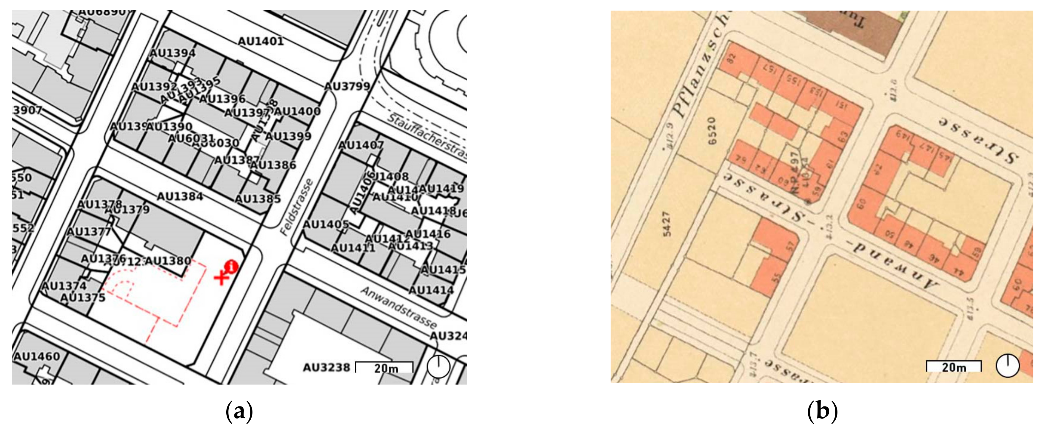
This increase in scale of new developments—both in volume and length—can be traced throughout history and can be linked to parcel size. Looking at the development of plot sizes over time, we can see a substantial increase in plot sizes. Two examples from Zurich illustrate this development. The first is located in the neighbourhood “Langstrasse” in the city centre (“Kreis 4”) and shows how a classical block of a “Gründerzeit” district (late 19th century housing) is divided. Within this characteristic perimeter for the Gründerzeit, exemplary historical plot sizes within the displayed area of
Figure 2b are around 240 m
2. On today’s cadastral map, we can see that most plots have the same outline. However, when new construction takes place, as indicated by the red dashed line in
Figure 2a, some plots get merged into larger plots. The new parcel identified with the red cross measures 1650 m
2.
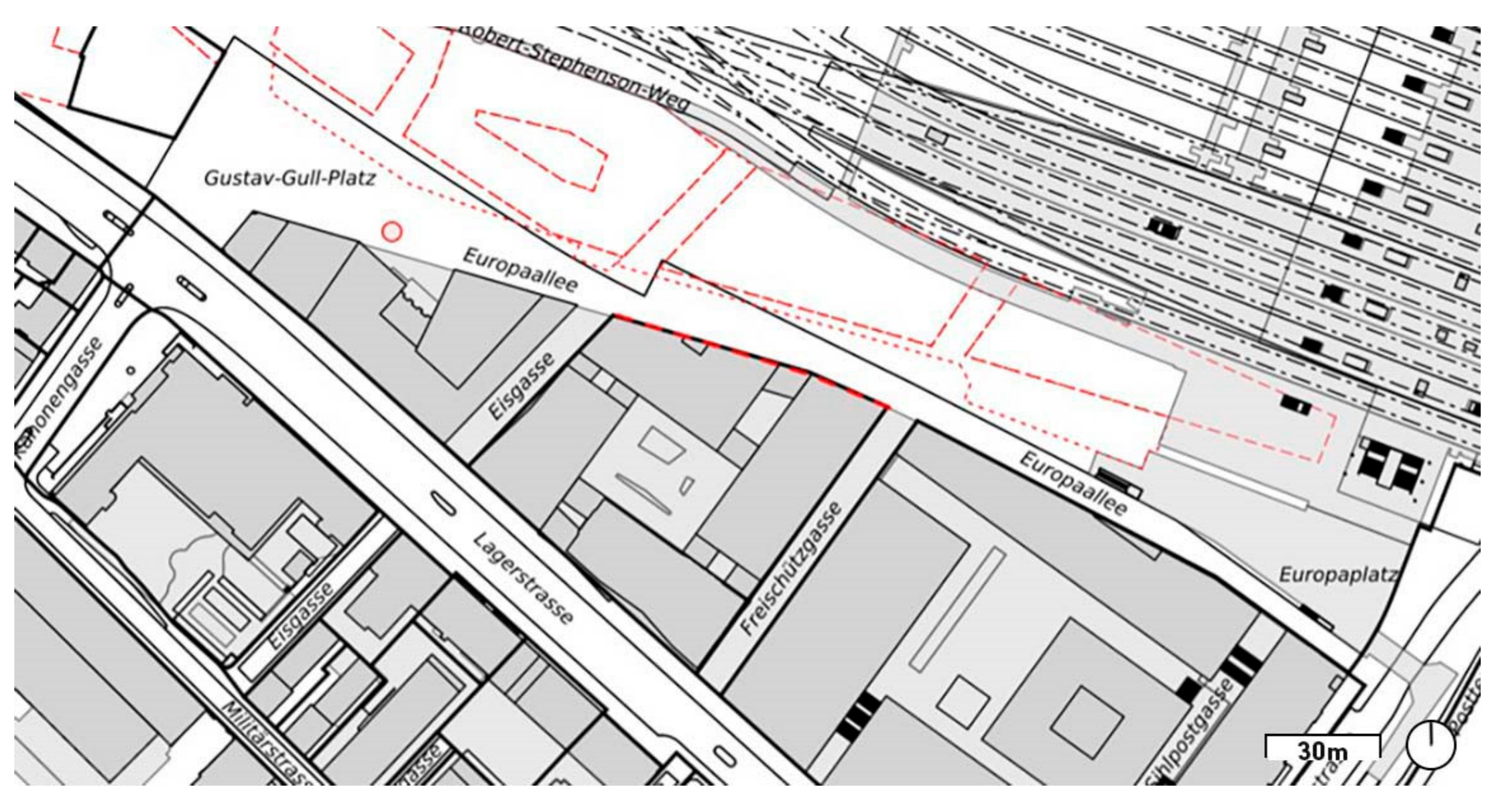
Such consolidations of parcels can be observed all over the city. Another example is the development area next to the main station in Zurich, the Europaallee (
Figure 3). It was parcelled out newly when this former railway station area was to be developed. In this case, the new parcels measure from 4000 m
2 to 20,000 m
2.
Why exactly these recent parcel consolidations and allocations were established is not of concern in this paper. However, these overall developments give context to why new developments are characterised by rather long and homogenous façades. In comparison to the Gründerzeit, developers today develop housing on much larger parcels, which can be designed and constructed using one single design.
This type of new and large-scale development is common practise and can be observed in new developments internationally [
11]. In contrast to these observed realities, studies have shown that streetscapes with a relatively high number of façade details as well as historical façades are considered pleasing [
3,
12,
13].
Some studies have aimed to identify the reasons behind the positive or negative evaluation of certain streetscapes. Different theories and methods for analysis have been developed, tested and applied [
12,
13,
14,
15,
16]. Two common explanatory concepts in the academic literature are the concept of complexity and the theory of fractals.
The concept of visual complexity in façades describes a relationship between a higher number of façade elements and the preference of people for them in contrast to rather simple façades [
17]. The theory of fractals follows the idea that the specific patterns of fractals appeal to human beings since they are the most common pattern within the landscapes surrounding humankind during its evolution. Examples of fractals are the cauliflower and clouds. Both are visually made up of repetitive patterns on different scales. Humans have evolutionarily adapted to these patterns, which we perceive today so easily that they evoke pleasing feelings. Pleasant streetscapes show similar fractal values as these landscapes [
14].
Even though none of these studies clearly state which visual aspects of streetscapes are actually part of these fractal patterns and therefore trigger the pleasing feeling [
16], the focus of all studies dealing with the perception of streetscapes is set on the architectural design elements of the façade. From the inconclusive research, it seems to be a premature conclusion to assume that it is the design of the façade that causes the positive response. This inconclusiveness of identifying what causes positive responses to certain built environments is also discussed by Alexander et al. in a study described in the previously mentioned pattern 95 “Building complex”. People found it particularly difficult to express why they exactly dislike the monolithic buildings Alexander et al. describe as non-desirable, which, in consequence, makes the study inconclusive on the reasons for the disliking. It seems that neither older studies nor very recent studies with the latest possibilities of technology can clearly pinpoint which elements of the complex multitude of elements constituting a streetscape are of core importance in triggering positive emotional response by the passers-by. The question remains: is it the level of detail and quality of design of a single facade that causes a positive response, or is it caused by the overall variety of facades independent of the actual design? In other words, does the answer to why positive responses are triggered by certain streetscapes lie in individual design questions or rather in structural considerations of the built fabric on a more general note? This question may be of central interest to urban planners since the authors have found that the regulation of structural considerations in our cities is normally much more widely accepted by the public as well as designers than the much more negatively perceived restrictions on the design of facades.
1.2. Hypotheses
Based on these considerations, this paper starts from the hypothesis that the architectural design of façades is not the core factor to produce positively valued streetscapes, but rather the length of the façades is! A rather short façade length causes a positive emotional response and streetscapes of human scale. A rule of thumb by the urban psychologist Alice Hollenstein in Switzerland states that a human on foot should be exposed to a new stimulus every ten seconds [
18]. Assuming an average walking speed of 4.8 km/hour, a new stimulus should be set every 13.3 m. Gehl [
3] even proposes a rule of thumb where a new stimulus should be set every four to five seconds. He considers a slightly lower walking speed of 4.5 km/hour, which leads to a new stimulus every five to six meters. Whether a façade should maximally only be 13.3 m long or set at an even smaller margin is up for discussion. What we can understand from this argument is that short façades add to for human beings interesting streetscapes. Alexander et al. [
5] touch on this topic as well. It is written that “a building complex cannot be a human building unless it is a complex of still smaller buildings”. In the pattern, Alexander et al. explain the idea in more detail on the basis of one individual building, which shows multiple so-called subdivisions. However, the image accompanying the pattern clearly shows one housing front made up by four to five story high row houses. In this regard, the relationship between the whole and its subdivisions is not only true for the individual building but also for streetscapes made up of different subdivisions and thus different facades.
The information presented up to this point shows that there is a large body of literature on how streetscapes are to be designed and what properties they should possess in order to be positively valued by passers-by. It also showed that the built-up reality does, in countless examples, not live up to the theoretically discussed standards and design principles. The questions naturally arising from these observations are firstly, why, but also, how this circumstance can or could be overcome. Considering this line of inquiry, the focus of this paper lies on the gap, or rather, the possibilities to bridge the gap between academic knowledge and the experienced reality of our built-up environment. The authors propose that the material for this bridge is to be found in planning instruments. Therefore, the main aim of this paper is to investigate the possibilities of planning instruments to regulate façade length in order to achieve a variety of rather short façades.
In this paper, we define a as the visual unity of a section of any building side facing public space. No final definition for the determination of this visual unity can be given since it is based on a variety of interconnected factors. Still, the case studies in this paper as well as a variety of factors give an indication of what can be understood as a façade. Factors used for differentiation between façade sections can include colour, material, floor height, horizontally or vertically arranged structural elements. Not all these factors need to be present at once, but certain visual aspects must clearly distinguish one building front section from another in order to be perceived as a unit, hence a façade.
A study indicates that, particularly, the variation of colour seems to be of core importance, as it is one of the most important factors to influence the level of complexity of façades and, therefore, the level of agreeability of the streetscape [
17]. In this paper, the focus lies on new developments in urban areas and, therefore, only non-detached façades are considered.
1.3. Research Questions and Goal
In order to test the above-stated hypotheses thoroughly, many questions would need to be answered. In this paper, the authors focus on assessing the possibilities of regulating façade length based on the evaluation of several case studies. The baseline for this assessment is the situation in Switzerland and the Swiss planning context. This also sets a certain focus on spatial situations that are comparable to developments in Switzerland. Hence, the main research questions of this paper are:
In which recent urban development projects in a Western European planning context is the length of façades regulated in order to achieve shorter façades?
Which instruments and regulations were used, and how can they be categorised?
What can be learned from these findings for the Swiss planning context?
By answering these questions, a non-conclusive overview of international planning practises on the regulation of façade length is given, which offers insights into possibilities to improve the Swiss planning system. Set in context to the international terminology of urban codes, this paper can be the basis for an international best-practice learning on the regulation of façade length in order to retain and regain liveable streetscapes for pedestrians.
1.4. Structure
This paper is structured into six chapters. In the “Introduction” (1) the hypothesis of this paper is contextualised by showing examples of recent monotonous façade designs. Linked to this, the increase of parcel sizes over time is illustrated with examples from Zurich. In “Materials and Methods” (2), an overview of the used methods and materials is given. The chapter “Differentiating urban coding” (3) gives insight into urban coding, both as a theoretical concept as well as specifically in its applied form in Switzerland. The term form-based code is introduced. In “Description of the Case Studies” (4), the cases are explained in detail as well as compared to each other at the end of the chapter. In the “Discussion” (5), the experimental case study of Schlieren in the canton of Zurich, Switzerland, is introduced and described, as are the overall findings for all cases discussed. The chapter concludes with both implications for the Swiss planning context as well as further research. In the “Conclusion” (6), the research question from the beginning is answered with the findings, before implications and final remarks conclude the paper. How the research in this paper is structured as well as how these different chapters relate to and are based on each other can be seen in
Figure 4 below.
2. Materials and Methods
This paper applies an explorative case study analysis as well as a comparative approach between these contemporary case studies in order to draw cross-case conclusions. The choice of case studies is not exhaustive but aims at offering a broad perspective on possibilities to regulate façade length. Therefore, a central search criterion was the largest possible differentiation between the cases in order to find special cases on the regulation of new development. The cases, therefore, do not represent the rule but the exception. The Western European context was chosen, since the evolution of planning systems in this area shares a similar timeline, a certain maturity of policy instruments and a breadth of planning tools, whereas, for instance, Eastern European planning systems are in comparison in another stage of their evolution [
19]. This does not imply any form of valuation of planning systems but simply gives a spatial restriction to our investigation in order to provide a similar context for the comparison of our case studies as well as the scope to compare them to the Swiss context. The information on the case studies is gathered from official planning documents, web sources by the respective design companies, and secondary literature on the case studies.
Methodically, the chosen approach follows inductive reasoning. However, the number of cases investigated is low, and, thus, generally applicable principles are hard to derive. This situation is quite common in urban design and spatial planning since spatial situations are complex, singular and therefore hardly comparable to each other and not easily transferable into generic conclusions based on scientific standards. Schön frames this as the dilemma of “rigour or relevance”—a situation where a choice must be made between the rigour of science and the relevance of the produced knowledge in order to deal with real-world-problems [
20]. Thus, the chosen method in this paper might be better understood as abductive reasoning, which tries to formulate hypotheses from a few observations [
21]. This method follows Schön’s approach of reflection-in-action [
20] and proves to be a valid option to produce knowledge in complex and not fully researched situations [
22].
4. Description of the Case Studies
The goal of the case studies is to give a broad perspective on the possibilities to achieve short and diverse façades and to understand the context within which they were made possible. The case studies are all structured in the same way. First, the case study location is introduced with some information on its background and context of development. This is illustrated by a photograph and supplemented by a short list of case study facts. Subsequently, information on the plot structure and façade design is given, which is illustrated by a map showing the plot borders and an aerial view. Last, the regulations shaping the design are outlined.
4.1. Case Study 1: Amsterdam, The Netherlands: Borneo-Sporenburg
Borneo-Sporenburg is the perimeter of a masterplan designed as part of the whole development of the Eastern Docklands in Amsterdam. The redevelopment of the harbour area was set in motion in 1989 by a national agreement to provide financial support for the provision of 6000 dwellings on KSNM island and Borneo-Sporenburg. This led to several corporations and builders joining together to form the New Deal Development Society with the intention of developing Borneo and Sporenburg in the community. With high ambitions for a diverse, small-scale, high-density neighbourhood, three teams, including West 8, were tasked with creating a master plan. Furthermore, several architects were asked to design and test possible house types of similar materials for a row home development [
27,
28]. The final design for the masterplan was developed by West 8, and the construction phase took place between 1997 and 2002 [
29].
This paper looks at a specific section of housing rows, which were from the beginning planned as single parcels that were to be developed by individual private owners. The section is the south-facing housing row on the northern part of Borneo Island (see
Figure 6).
4.1.2. Lot Structure and Façade Design
As can be read from the cadastral map in
Figure 7a, the rectangular parcels measure 16 m in length and vary in width from 4 m to 9 m, with an average of about 5 m [
30]. Each building is designed and developed individually (see
Figure 7b) and is usually occupied by one tenant. The façades are all designed individually, and the combination of different windows, dimensions and choices of materials suggests that no binding specifications were made in this respect. Although a large part of the façades is clad with the typical Dutch clinker brick of various colours, there are also façades with wood or (stone) panels and full glazing [
9,
29]. Overall, one gets the impression of a very varied and diverse row, which, thanks to the similar building height and common building line, is understood and read as a unit.
4.1.3. Regulations
In the Netherlands, a “Bestemmingsplan” regulates the built form within the whole jurisdiction of a municipality (see
Figure 8). Based on an urban design concept or plan, the “Bestemmingsplan” can be set up [
31]. The masterplan by West 8 for Borneo-Sporenburg was also translated into a “Bestemmingsplan”, which was adopted in 1998 and approved in 1999 [
32]. The masterplan set strict but imaginative rules for the development, including guidelines for streetscape, parking, private open space, building height and plot width [
29]. The “Bestimmingsplan” took these ideas and made them into binding building rules [
32].
4.2. Case Study 2: Malmö, Sweden: European Village
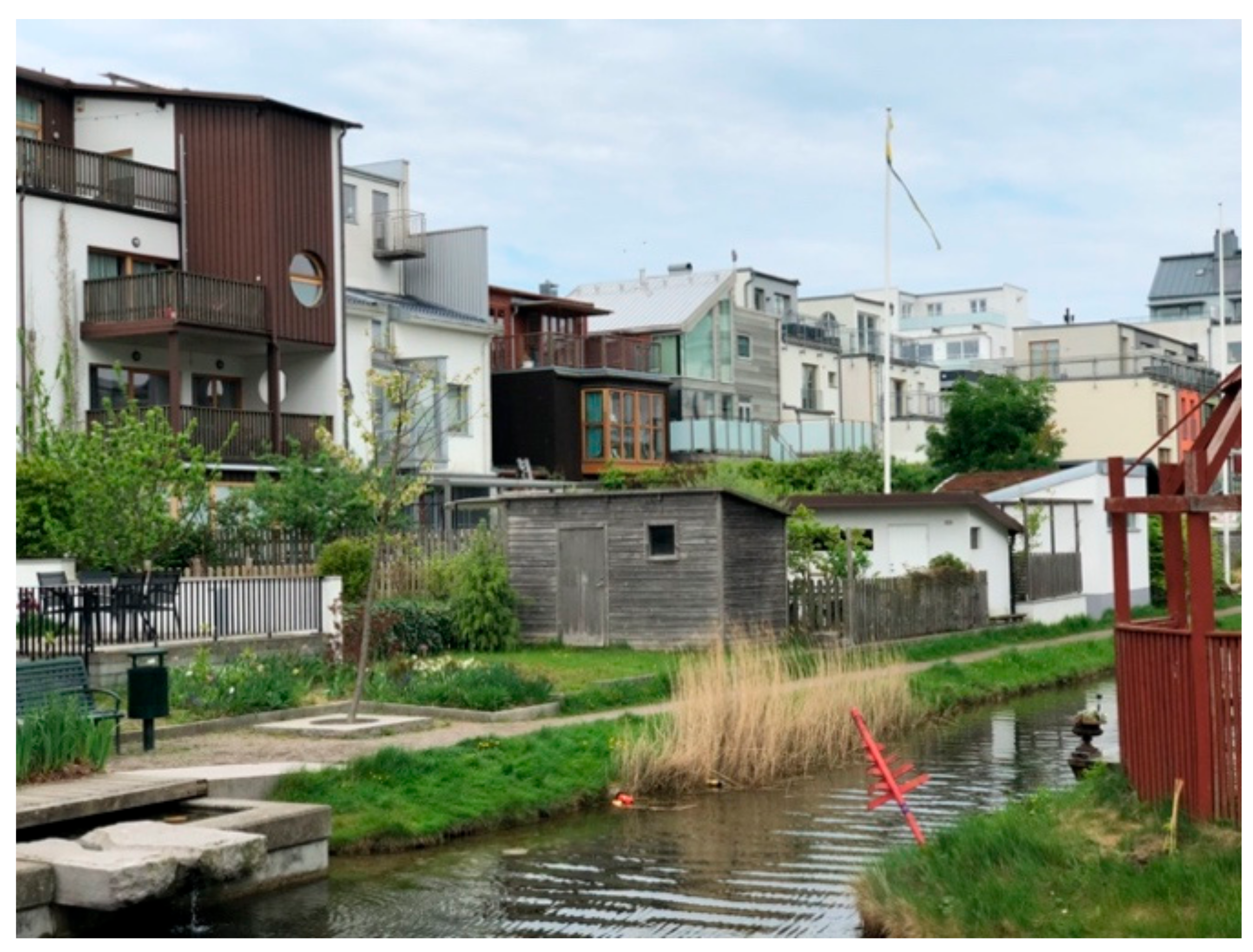
The European Village (see
Figure 9) is part of the masterplan for Bo01, which lays on the Västra Hamnen in Malmö, Sweden. Västra Hamnen is a former industrial and port area that has become increasingly redundant since the 1970s. From the 1990s, the city of Malmö has recognised its potential for a future-oriented sustainable development (“City of Tomorrow”) close to the city. This ambitious project (100% self-sufficient) was underpinned by the LIP (Local Investment Program) and other EU funds for renewable energy, as well as Sydkraft (a regional energy company). As a prelude, a housing expo was held in the north of Bo01, which opened in 2001 and showed 12 exemplary sustainable buildings from different European countries. Meanwhile, the city sold the building rights of the remaining parcels of Bo01 to developers. These developers were obliged to join the association “Owner” group and collectively establish building standards called the “Quality Program”. The director was Klas Tham, who is also accountable for the design of the master plan. The masterplan foresees larger and taller residential units along the seafront to protect the inner buildings from wind and thereby create a more intimate feeling. Distorted and small-scale networks of bicycling and walking paths connecting the smaller lots and several public eco-friendly recreational spaces [
33,
34].
4.2.1. Case Study Facts [35]
Year of completion: 2001 (European Village exhibition);
Architect; Masterplan: Klas Tham; 26 architects;
Duration of planning: 1995–2001;
Duration of construction: 1998–2006;
Lot size: 120–150 m
2 per private plot [
36].
Figure 9.
Photograph of case study 2: European Village. Source: authors.
Figure 9.
Photograph of case study 2: European Village. Source: authors.
4.2.2. Lot Structure and Façade Design
Looking at the cadastral map (see
Figure 10a), the European Village is characterised by a particularly small-scaled plot structure. One of the smallest plots on the site in the north-west area measures approximately 125 m
2. One of the larger parcels in the southwest area measures approximately 285 m
2. The rest of the Bo01 development area also has a rather small plot in comparison with the surrounding areas, however they are much larger than what can be found in the European Village. Since the land belonged to the municipality, it was also the municipality that predefined the lot structure and then sold the plots to developers for the design. At the core of the development stood the sustainable building practises from across Europe. Based on this idea, different architects build different houses with the aim of sustainability [
33,
37].
The houses are positioned next to the walkway and open up towards the waterfront, featuring a private garden (see
Figure 10b). While some of the houses are perfectly aligned, others jump slightly back and forth due to the changing boundary line of the lot (see
Figure 10a) and also due to some individually added balconies or some cut-outs/backs. At the end of the exhibition, the vacant lots were filled with rather standardised townhouses. The chosen house type was replicated several times, varying only in the selected colour of the façade. Opposite to this, the exhibited houses varied greatly in their volumetric expression, opening dimensions and use of façade materials. Such diversity was encouraged by the call for countries to portray their styles, materials and construction methods typical of their traditions and to adapt them to the climate and living conditions in Malmö. Changing floor heights and different roof designs result in a wild roofscape. At the same moment, a whole range of different materials have been used, such as coloured wood, brick and abrasion, which also goes hand in hand with a variety of windows ranging from round portholes to fully glazed walls [
9].
4.2.3. Regulations
In Sweden, the municipal planning instruments contain two levels (
Figure 11). The “Översiktsplan” is the main and mandatory planning instrument. It must cover the whole municipality, but its content is not legally binding for landowners. It mainly directs the land use in land and water areas [
26]. The “Detailjplan” provides detailed urban codes that are binding for landowners. “Detailjplans” does not have to be prepared for the whole municipality, but only for areas where the change of land-use has to be controlled and detailed specifications have to be given. “Detailjplans” are valid only for the implementation period between 5 and 15 years [
26].
For the Bo01 development area, a “Detailjplan” was also prepared. However, the main instrument was a masterplan with its quality program, which all landowners had to develop together in the so-called owner’s group [
38]. One aim of this quality program—besides regulating public space, technical infrastructure, water and waste management—was to diversify façades for larger buildings. It was the explicit aim to break with the monotonous character of modern building complexes, which were inspired by the looks of medieval Hanse cities [
38,
39].
4.3. Case Study 3: Nordhavn, Copenhagen, Denmark: Harbour Park
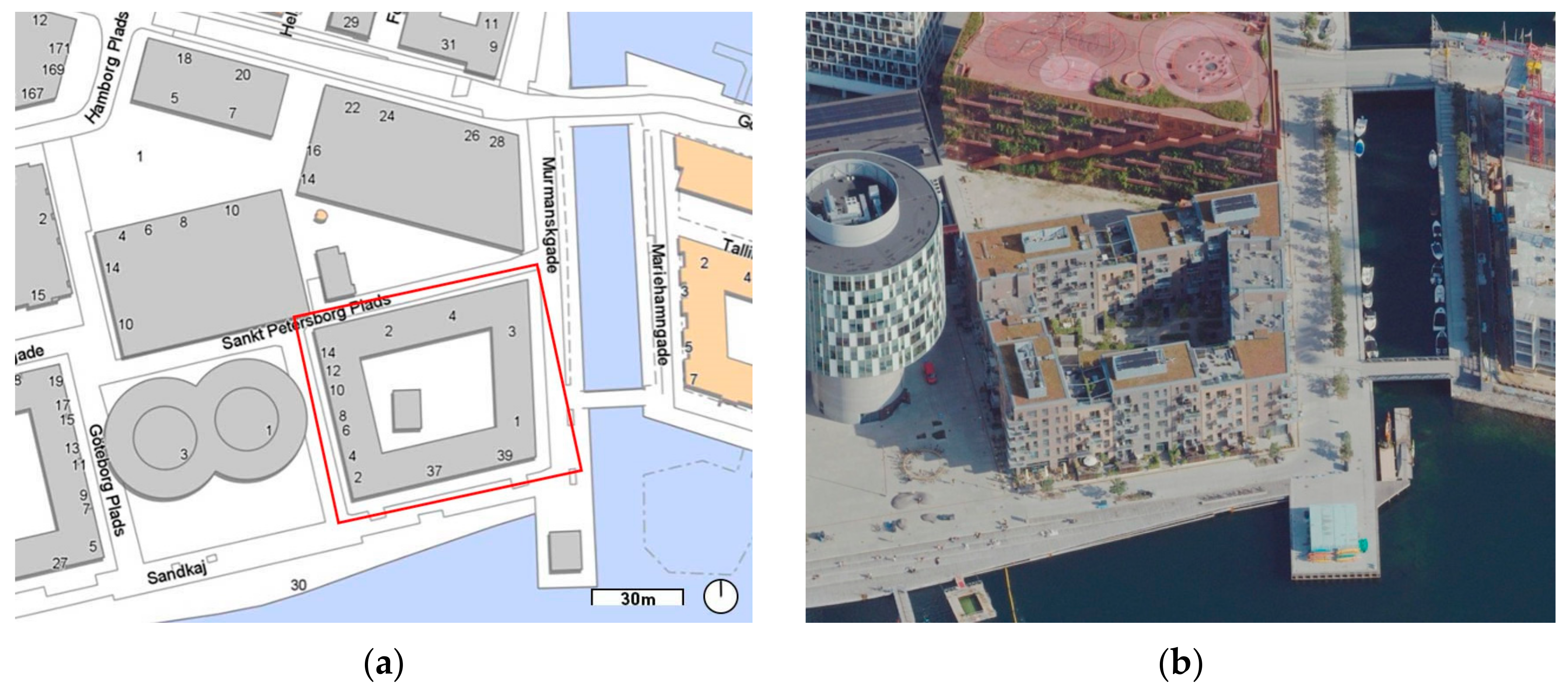
The third case study is in the urban extension of the city of Copenhagen: the Nordhavn. The former docklands are located in the northeast of the city. The first realisation phase of the masterplan from 2008 is now under construction [
40]. The case study, Harbour Park (
Figure 12), is part of one of the first development phases and is located in the south of the Nordhavn, one of its areas closest to the old city.
4.3.1. Case Study Facts [41]
Year of completion: 2015;
Architect: Danielsen Architecture;
Duration of construction: 1 year;
Duration of planning: 2008 masterplan for Nordhavn, 2018 Lokalplan for Nordhavn;
Lot size: about 3450 m2.
4.3.2. Lot Structure and Façade Design
The focus of the analysis is one plot (see
Figure 13a). It measures roughly 3500 m
2. The building block on this lot was designed and constructed in one phase. All four sides of the building block are made up of five to seven façades (see
Figure 13b). Looking at the block aesthetically, there are elements of the façade that evoke a feeling of unity and elements that differentiate the block sides into individually readable façades. The differentiation of the façades is based on three dimensions. First, even though brick was used as the main material for all façades, there are three shades of brown in the bricks. This colour differentiation acts as the basis for the basic separation of the building block side into different façades. The second dimension is the height of these individually readable façades. Through this differentiation, the impression arises that behind each façade, an independent house can be found. Looking at the architectural interior of the building block, we understand that this is just an illusion. The third dimension is the balconies. These are placed in different variations across the building block sides.
The staircases tell the story of which building compositions function as individual building units. The staircases of Harbour Park tell us a different story than the façade may imply. The building block side facing south towards the Nordhavn Bassin only has one set of staircases [
42]. Considering that this front is visually made up of five façades, it is clear that the façades do not stand for one individual building. The façade tells us nothing about the internal structure of the building. Therefore, these façades are an aesthetic consideration and not based on the construction of the building.
4.3.3. Regulations
In Denmark, urban codes are organised similarly to the Swedish model mentioned above. The “Kommuneplan” is a comprehensive land-use plan for the entire community. “It has the role of integrating the different objectives of higher-level strategic plans into a comprehensive policy document that specifies overall objectives for development, includes guidelines for land use and provides a general land-use framework for the municipality” [
26]. A more detailed “Lokalplan” has to be made for every major development project, such as Nordhavn. It can regulate details about the land use and the appearance of buildings (see
Figure 14) [
26,
43].
The development of Nordhaven was guided by a masterplan designed by COBE architects. One element of the masterplan is the development plan. This document regulates the character of Nordhavn [
44]. It states that the plot sizes are relatively small in comparison to other newly developed areas and that through smaller and larger buildings, the neighbourhood should be built to a human scale. The elements of the masterplan were then translated into a “Lokalplan”. Regarding the façades, two regulations are crucial: §7 states that “The buildings’ façdes must be executed with great variety and detail, with clear changes in the façade, which include several of the following elements: Change in architectural expression, colour, materiality or rhythm. There must be at least two shifts per façade stretch.” §6 demands that each of the construction fields […] must contain at least three jumps in the height of the building, where the jump in the building height is a minimum of 3 m [
44]. While the jumps in the height of the building are clearly visible in all the blocks, the “change in architectural expression” is most visible in the examined building block.
Figure 14.
Organisation of spatial and land-use planning in Denmark [
26].
Figure 14.
Organisation of spatial and land-use planning in Denmark [
26].
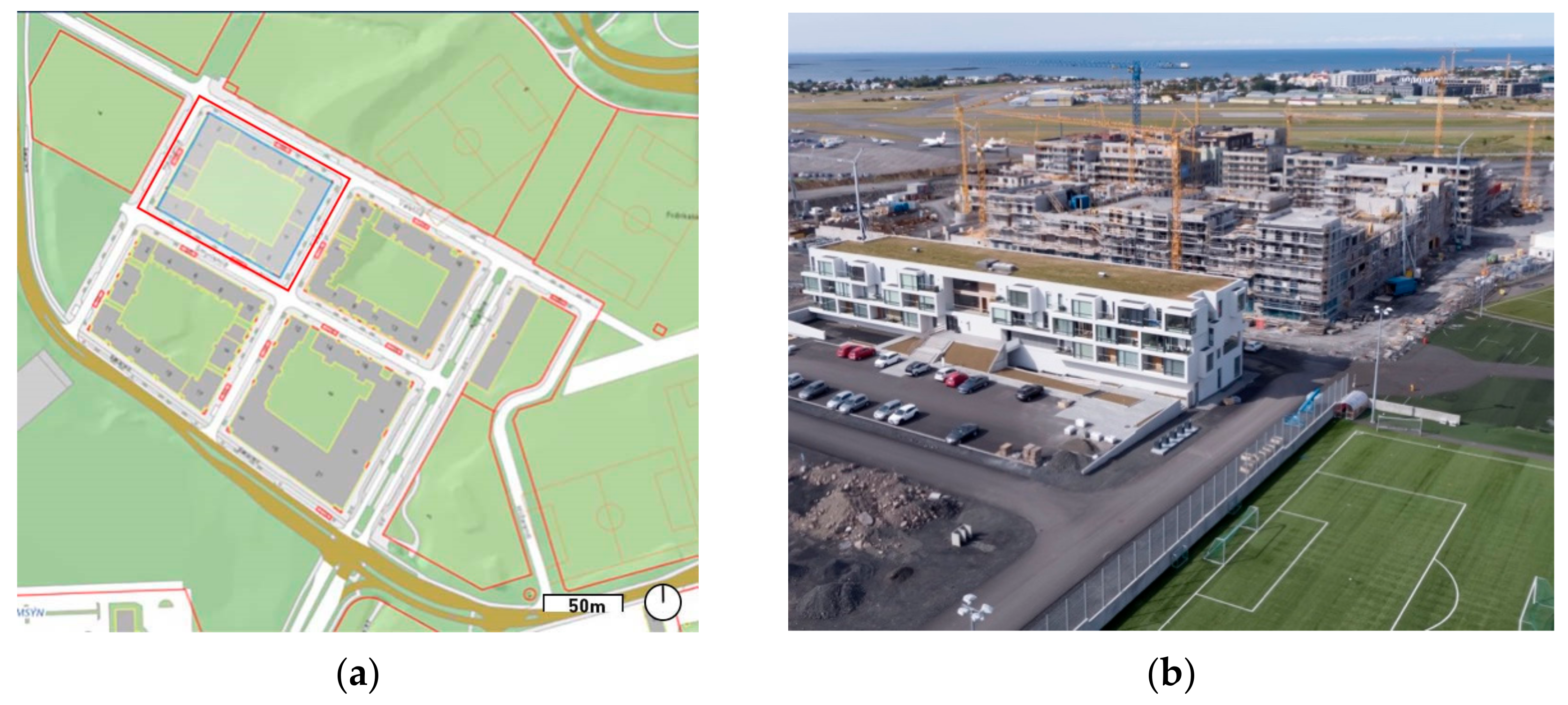
4.4. Case Study 4: Reykjavik, Iceland: Hlíðarfótur 13–17
The building block looked at is located in the Hlíðarend development, close to the domestic airport in Reykjavik, Iceland. The total size of the Hlíðarend-development is 7 ha of which the block is one of six. The case is one of several recent developments in Reykjavik where different façades appear in one building (see
Figure 15). The case was chosen, because the originally planned project was altered during the design phase from large row buildings to this special style of blocks with different façade-styles. The masterplan for this development by Alark is based on a design by the Scottish office GraemeMassieArchitects [
45], who won the urban planning competition for the whole area of the domestic airport called Vatnsmyri.
4.4.1. Case Study Facts [46]
Year of completion: 2022;
Architect: Master Plan ALARK;
Duration of construction: 2014;
Duration of planning: 2004–2017;
Lot size: 6594 m2.
4.4.2. Lot Structure and Façade Design
The plot analysed in this paper is in the north-west corner of the Hlíðarend development area (
Figure 16a). Its longest block side measures 95 m. The block consists of seven buildings built with enclosed construction. Each building has between one and three different façades [
47], varying not only in colour, material and expression but also in height. Not every façade has its own entrance but appears as a separate building. The lot structure seems to be one development by one landowner but sold to private clients after competition [
48].
4.4.3. Regulations
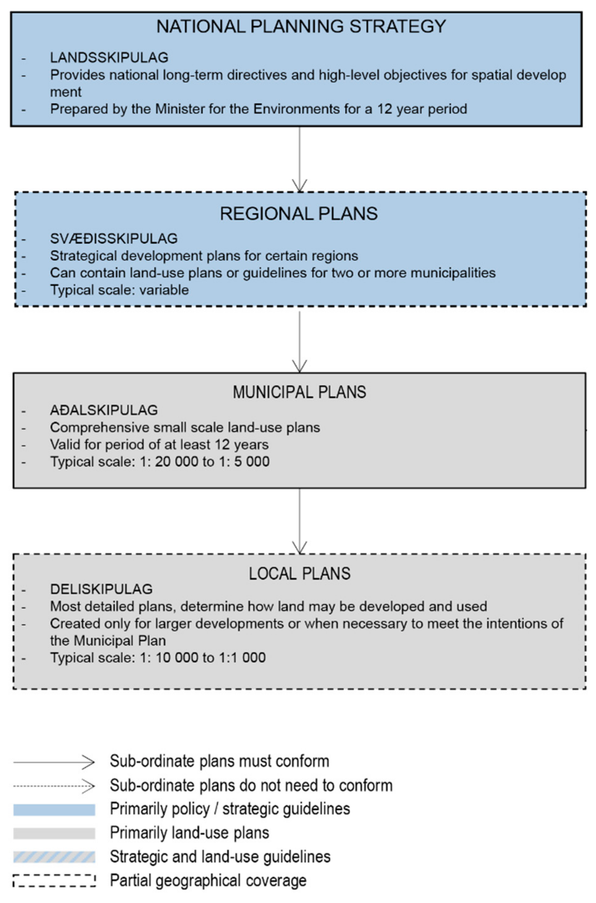
Iceland organises its municipal planning in two layers (
Figure 17). While the municipal plan (“Aðalskipulag”) covers the main information of basic urban coding like in Denmark and is described in Chapter 3.1 for the whole municipality. On certain neighbourhoods and projects, local plans (“Deiliskipulag”) can be implemented [
50]. The “Deiliskipulag” for the Hlíðarend area does not only regulate the block size and dimension but also acts as a style guide. In this document, it is explicitly stated that homogenous walls are to be prevented by subdividing the block sides. The longer north and south sides must be divided into at least five units (read: façades), and the shorter east and west sides must be divided into at least four units. The exact lengths are not defined, so there is still room for creative interpretation. However, the district plan goes even further and recommends that a repetition of the same materials and colours be omitted [
51]. An interesting fact is that the original plan for the neighbourhood was totally different. In 2004, the local plan shows line buildings with big parking lots around them [
52]. It can be assumed that after the urban planning competition for the whole area of the domestic airport [
53], this development was questioned and altered in the form in which it is now visible.
4.5. Interim Conclusion on the Comparison of the Approaches
The following comparison of the case studies summarises the core similarities and differences between the approaches. The goal is to identify the crucial factors for the resulting appearance of the buildings.
Borneo-Sporenburg and the European Village share one core factor: they are both characterised by a fine-grained structure comprised of a multitude of plots. This prerequisite was the decisive factor for the façade variety perceptible in these streetscapes. In both cases, the architectural designs are rather diverse and were not regulated much. They are, therefore, both prime examples of how a solid and thought-through structuring of the parcels can define the urban fabric. This led to achieving the set targets without having to regulate the design of the buildings themselves much.
However, obstacles arose during construction, which must be discussed in order to understand why such developments are not more common. Whereas the masterplan by West 8 for Borneo-Sporenburg only intended the longest repetition of the number of row house typologies to be 12, the intervention of developers during construction led to much longer sections of the same repeating houses. In some cases, the fine-grained vertical structures were even abandoned for longer horizontally oriented structures [
54].
In the case of the European Village, the context of the project played a key role. It was no average development under market conditions. The development was realised as a building exhibition. The aim was to provide housing with high accessibility by public transport and, therefore, reduce the provision of parking spaces for cars. However, due to its immense popularity, prices for these houses went up immensely, and, in the end, a large neighbourhood parking garage had to be built in order to accommodate the high demand for parking spaces [
37]. Thus, in both cases, the aim to achieve streetscapes with a high variety of façade diversity had to face the effects of market logic.
The case of Harbour Park, Denmark, shows a development constructed on one large parcel. The existing local plan demanded a division of the façades and a variation in height. Thus, not the parcel size but legally enforced codes motivated the division of the building sides into different façades. However, the design of the examined block is much more in accordance with the legal codes than that of the surrounding buildings in this area. In comparison to the other cases discussed in this paper, the differentiation between these different façade sections is therefore rather subtle. Professional expertise is not needed to recognise that the building block is, in fact, one building and not made up of individual buildings. Whether this is aesthetically favourable or not is not part of this discussion, but it can be noted that the subdivision into different façades in this case is of a purely visual nature.
The fourth case of Hlíðarfótur again poses a different approach. Similar to Harbour Park, the development is set on one large parcel. However, in this case, a form-based code precisely states into how many façade units the building block sides must be divided. Whereas these regulations are of a legal nature, there are advisory formulations that state that the colouring and materials should be different. Looking at the built project, the colour variation is indeed applied within a spectrum of shades of grey and red. The materials seem to be rather similar and characterised by smooth surfaces. Again, whether the result is visually appealing or not is not the focus of this discussion. Rather, it can be stated that in this case, regulatory measures enforced the outcome of a high variety of differently sized façades alongside the building blocks.
The comparison of the case studies can be summarised in their core characteristics in the following
Table 1.
These cases show two possible strategies regarding the regulation of façade lengths:
One possibility is the pre- or re-definition of the parcel structure. Just as the Borneo-Sporgenburg case and the European Village have shown, it seems to be an effective approach to divide the site into small parcels. This leads to the desired outcome of a multitude of façades in the streetscape because every building is designed and built separately. As far as the authors could tell, the formal planning regulations in these two cases are rather weak and consist mainly of design principles defined within the masterplan.
In contrast, the cases of Harbour Park and Hlíðarfótur do not show a small-scale parcel structure but were realised on one big development area. The diversity within the Hlíðarfótur development was achieved by a set of differentiated and legally binding planning regulations. The case of Harbour Park shows the same mechanism but in a rather subtle form. In both examples, the possibility of formulating more precise, legally binding guidelines in the local plans (Lokalplan (DK) and Deiliskipulag (IS)) led to short, distinguishable façades even if the building itself was much bigger.
What all four case studies have in common is their application to certain predefined project perimeters. All four cases were developed on one big parcel. Furthermore, all can be understood as specific strategic development projects within their respective cities. Therefore, they must be understood as the exception rather than the rule: a special case within the average building logic of the city as well as a special case in the use of available planning instruments. Considering that these planning procedures stretched over many years, the conclusion can be drawn that they are very complex and use a lot of resources. It shows that achieving differentiated and diversified streetscapes is indeed possible, but it also seems that today a lot of effort must be put in to adhere to a human scale.
5. Discussion
5.1. Thinking the Approaches Further
The cases show two different ways to achieve differentiated streetscapes with reduced façade lengths. They also show that all case studies are implemented in limited project areas with some sort of special regulation. The research for this paper revealed no cases where instruments were elaborated to regulate façade length on the scale of larger areas of a city, such as the neighbourhood scale, rather than on the individual parcel scale. So, the question arises: what possibilities exist to implement reduced façade lengths at the level of existing neighbourhoods and cities? As the case studies of Borneo-Sporenburg and the European Village showed, small-scale parcelling can run into multiple issues. This brings us back to the regulations of form-based coding discussed in
Section 3. With other words: Can a sort of form-based code on façade length solve this issue and lead to shorter façades in much larger parts of a city?
5.2. Experiment: Building Code of the Commune of Schlieren, Canton of Zurich, Switzerland
In Switzerland, the discussion about liveable streetscapes is mainly focused on public street space and how buildings face the street. One example of this is the town-boulevard (“Stadtboulevard”) in the commune of Dietikon, Switzerland [
55]. Its focus lies on ground-floor uses, the height of buildings and the design of public spaces. It is interesting to note that the visualisations of the concepts show a variety of buildings with limited façade lengths. The formal planning instrument to make these concepts legally binding is most often the so-called “Gestaltungsplan” (Design-plan) [
56]. At first glance, this might seem like an appropriate tool to regulate façade length; however, it must be remembered that this instrument is again project-oriented and binds many resources in its creation. In the example of Dietikon, a second possibility was considered, which was to revise the building regulations alongside the street to allow denser and higher buildings [
57]. This approach uses regulatory elements of conventional zoning to reach the desired outcome on a larger scale. However, in the case of Dietikon, only the density was regulated and not based on other aspects such as façade length.
The aim of the partial revision of the building code of Schlieren (which neighbours the commune of Dietikon) was to use conventional zoning and include form-based elements to regulate façade length and, therefore, make strategic concepts from a preceding planning stage legally binding for property owners (“Kommunaler Richtplan”, [
56]). This experimental planning procedure was carried out in practise by the authors Nollert and Gatti. A new overlaying zone over the already existing basic zoning regulation was specifically designed and formulated to regulate the main street axis of Schlieren. For the overlaying zone, a relatively new zone implemented in the city of Zurich was used as an orientational framework: the “areas of increased floor-area-ratio” (“Gebiete mit erhöhter Ausnutzung” [
57]). Within a 12 m-wide strip from the street boundary, significantly more floor area can be built than outside this strip.
This added financial value for investors was used as compensation for various regulatory specifications. These types of regulatory specifications were not part of the original zone created in the city of Zurich. First, the bonus of the floor area ratio was combined with the possibility to build right up to the property line, which made a non-detached building structure (“geschlossene Bauweise”) possible. Second, the possibility was offered to build overheight ground floors. Third, the main innovation was a mandatory building regulation that limited the maximum façade length to 15 m. In cases where the length of the plot is not easily divided by 15, a simple calculation was provided for every investor to understand how many façade sections had to be built. This code aimed at the possibility of either building different houses directly next to each other, just as in the case study in Amsterdam, or to building larger buildings with different façade elements, such as in the case study of Reykjavik.
The proposed building code [
58] was recently under preliminary examination by the canton of Zurich. The draft was rejected by the canton. The reason for it was the ambiguous legal basis of the cantonal law. The planning and building law of the canton of Zurich, which forms the binding legal basis for all communal building regulations, does not allow any building specifications of a form-based kind in residential zones [
59]. As explained in chapter 3, because the proposed overlaying code was to be used mostly in residential zones, there is no legal basis to make specifications about the form of buildings.
5.3. Overall Findings
Based on the analysis of the four already implemented case studies and the experimental case study in Schlieren, multiple findings can be summarised. Based on the analysis of the case studies in this paper and the learnings from the experiment in Schlieren, the following categorisation (see
Table 2) of regulatory strategies is proposed.
The case studies show several valid options to regulate façade length as one important aspect of human-scaled streetscapes:
To achieve an actual variation in façades, the best option still seems to be to regulate parcel size and allow a non-detached building structure (geschlossene Bauweise). As the case studies of Borneo-Sporenburg and the European Village show, a further advantage might be to ensure that these parcels belong to different owners.
The economic reality of the real estate industry and the applied logic of urban development today do not seem to make this the easiest option. There might be two reasons for this: recent projects of urban renewal and conversion have taken place mainly on large brownfield sites with one or just a few landowners. With the subdivision of a small number of larger parcels into many smaller ones and, with it, the realisation of multiple smaller building projects, the complexity of the project rises while the direct revenue might decrease (even though the case study of the European Village also shows the possibility of quickly and significantly increasing house prices). Thus, from the perspective of the real estate industry, it might often make no economic sense to carry out projects on small parcels.
Therefore, the case study of Hlíðarfótur in Iceland offers a powerful alternative to overcome this parcel-based shortcoming through the introduction of a regulatory framework. By regulating the number of different façades, the investor and the designer can choose the way they want to meet these regulations. They have the option to build different buildings or—as in the case of Reykjavik—build one single building with different façades, while optimising the facilities inside the building. In this way, the economic goals of investors as well as the goal of achieving a liveable streetscape with varied and short façades can be reconciled.
A discussion on the quality of the aesthetic outcome of the second option would suggest itself. However, this discussion requires further research into people’s preferences, which this paper cannot offer. It can only be stated that compared to recent projects with monotonous façades or repetitive façades, the increased number of stimuli from shorter and differentiated façades leads to an increased number of stimuli for pedestrians, which, as in previous studies, have been shown to add to the positive valuation of streetscapes.
All the investigated project-based case studies known to the authors were developed through “special” planning instruments within their respective countries. They were all part of strategic development projects requiring many resources (time, money and experts) and which did not make use of standard building regulations. However, today’s tasks of urban transformation and the densification of the existing settlement structure—where streetscapes can play a key role—do not ask for singular solutions but for solutions applicable to much larger parts of cities. In such cases, urban codes can come into full effect.
It is therefore the authors’ assertion that possibilities must be found to regulate façade length within the standard building regulation so that they are not only advisory in character or only applicable within predefined perimeters but apply whenever new buildings or neighbourhoods are designed. The Schlieren experiment shows that the combination of basic zoning instruments with form-based codes could be a valid option to implement human-scale streetscapes in wider areas such as neighbourhoods or even whole cities. However, it also showed that at least in the canton of Zurich in Switzerland, the legal basis has not yet been given to do so.
5.4. Implications for Swiss Formal Planning
The possibilities for implementing elements of form-based codes vary and are highly dependent on the formal planning system within which they are to be implemented. Therefore, general implications for zoning laws cannot be given. Due to this paper’s strong connection to the Swiss planning context, implications for Swiss formal planning instruments can be explained.
As mentioned before, the Swiss formal planning system features an instrument called the design-plan (“Gestaltungsplan”), which allows all kinds of regulations regarding form, land use and the design of buildings. Technically there is the possibility to implement form-based code as applied in the case study of Hlíðarfótur in the canton of Zurich. However, to the authors knowledge, there are no examples of design-plans in Switzerland which made use of these possibilities in the manner seen in Reykjavik.
As explained at the beginning of this paper, design plans are excluded from this piece of research since they are an instrument for “special”, singular and project-based situations. This instrument’s high frequency of use has been criticised in recent times. If the original intention of planning is to offer a basic set of general rules in order to reduce the investment of resources every time somebody wants to build, then project-based and special-use plans must remain the exception. However, if planning practise keeps on working with this sort of plan, then suddenly the exception becomes the rule. To address this issue, there are two possibilities. Either the design plans become the primary coding tool or the existing standard building regulation is adapted to also include aspects of form-based coding. The authors advocate for the second form of renewal. This approach to regulating the built environment offers a basic set of quality-oriented but open set of rules that provide landowners with long-term planning security (“Planungssicherheit”). Planning security means that the basic set of rules given by, for example, form-based codes already indicate in advance what building possibilities exist on a plot of land. This type of urban, or specifically form-based, code offer, in addition to planning security, flexibility to designers and investors.
Looking into the existing formal planning law in Switzerland, hindering factors for form-based codes can be identified. Provided that liveable streetscapes need at least partially non-detached building structures, the first shortfall of many Swiss planning regulations is the predefined and binding distances between buildings (“Grenzabstände”). These regulations were developed at a time when greenfield suburban development was predominant and, therefore, the main focus of regulatory practices.
At this point, it is important to note that the term “building length” in Swiss formal planning is confusing, since it refers to a coherent building frontage. If the building regulation demands a rather short building length, then a non-detached building structure cannot be implemented. In some cantons, long buildings, aka non-detached building structures, cause such large spacing requirements (the so-called “Mehrlängenzuschlag”) that the implementation of such structures is impossible in practice.
The second obstacle stems from the cantonal planning law of the canton of Zurich. This legal basis forbids that in residential zones regulations regarding the building form be formulated, except for height as well as the length and form of the roof. Therefore, neither specifications regarding the shape and use of the ground floor, the way the building is placed in relation to the street front, nor the appearance and length of the façade may be regulated. Changing the cantonal law, if attempted at all, takes time and cannot be expected to be achieved quickly. To sum up, this reflection shows that different legal steps must be taken until form-based codes are feasible within the standard building regulations of communes in the canton of Zurich.
A third issue is that “façade length” is not a formal term in Swiss building regulations. Therefore, attempts to formulate rules with this concept in mind fail, as the experiment in Schlieren showed. In the recent attempt to unify the cantonal building terminology (“IVHB Interkantonale Vereinbarung über die Harmonisierung der Baubegriffe” [
60]), no differentiation was made between building length, façade length and block length. Since the IVHB was only recently released and is now in the process of implementation, renewed changes to the terminology are improbable.
5.5. Further Research
Several points can be suggested for further research. First, as discussed in the introduction, studies should investigate more broadly the variety of built-up elements of a streetscape that can lead to its positive evaluation. This might offer better insight into the significance of short façade length. Findings from such research could shift the discussion away from focusing solely on façade designs and façade details to structural factors of the streetscape, such as façade length. Highlighting this or other structural components that lead to the positive valuation of streetscapes might give urban planners more founded claim to regulate these elements with the giving planning tools without being accused of unnecessarily intervening in the design choices of architects.
Second, the issue of parcel size must be opened up for discussion again with regard to the economic logic of investors. This investment logic is often mentioned as a reason for preferring large parcels and uniform building designs. Research should clearly identify, from a financial point of view, which hindering factors keep real estate investors from investing in small-scale parcelling or diversified façades. Whilst short-term considerations might lead to the large and monotonous buildings visible nowadays, the long-term economic value of liveable streetscapes with a diversified “landscape” of façades or buildings might be higher than expected, as the case of the European Village in Malmö shows. New findings based on this real-estate logic could change initial investment considerations.
Third, and connected to the second point, more research should focus on identifying reasons why the possibilities to regulate façade length are not widely used in order to find approaches to tackle this condition. For the Swiss context, there certainly is a legal barrier to including a form-based code on façade length in the standard building regulation; however, it would be possible in guiding plans. This chance has, to our knowledge, never been taken. The question still remains as to why this is exactly the case.
Fourth, the proposed categorisation in this paper on the possibilities to regulate façade length is only based on a small number of case studies and must, therefore, be discussed again based on more cases. Form-based codes from the US should be looked at in more detail, particularly focusing on practical examples and not just on theoretical considerations. In relation to this, each case study might require more thorough research in terms of their national regulatory planning framework. By giving more in-depth insight into the national planning context, knowledge transfer can be fostered, and more planners can profit from ideas and learnings from other planning systems.
6. Conclusions
In this paper, it is shown that a gap exists between, on the one hand, the large body of work made up of academic studies and theoretical considerations on the ideal and positively valued form of streetscapes and, on the other hand, the frequently rather negatively valued streetscapes that are often built today. Based on the large body of literature and our own expertise as planners, the hypothesis that short façade length is a core factor to trigger a positive valuation of a streetscape was formed. With the initial observation and the hypothesis in mind, a search for case studies was conducted in order to find actually built case studies where short facades were implemented. Through this search, the first research question can be answered. It asked in which recent urban development projects in a Western European planning context the length of façades is regulated to achieve shorter façades. The four presented case studies stem from Amsterdam in the Netherlands, Copenhagen in Denmark, Malmö in Sweden and Reykjavik in Iceland.
However, these cases remained the exception and were not just developed under common free market conditions but were highly regulated in order to achieve the targeted short façade length. Through the analysis of the cases, the second research question can be answered: which instruments and regulations were used, and how can they be categorised? The two main instruments identified for the regulation of façade length are the regulation of parcel sizes and text-based formal regulations. Both were mostly observed on a project scale, thus only applicable to very specific sites with a limited spatial scope. The proposed categorisation of the identified possibilities to regulate façade length is based on a two-dimensional matrix. The two dimensions are spatial scope (project-based or neighbourhood-wide) and means (via parcel structure or a regulatory framework).
The case studies show that it is not a lack of instruments that makes buildings with short facades the exception today, but seemingly the lack of use thereof. This paper gives deep insight into these hands-on planning instruments that allow the regulation of façade length and offers a categorised overview of these possibilities. It can be seen as the foundation of an international knowledge exchange for practitioners and offers a theoretical starting point for further academic research on the topic.
The third research question asked what specifically can be learned from these findings for the Swiss planning context? Both the case studies of Hlíðarfótur and Schlieren showed that the regulatory approach can be a powerful formal planning tool to regulate façade length. Via form-based codes, façade length regulations can be introduced into basic zoning. However, in order to do so, the cantonal planning law of Zurich must change to make this legally feasible. The current lack of awareness that form-based codes could be an added value to regulate façade length in Swiss streetscapes is also reflected in the lack of differentiation between block length, building length and façade length in the IVHB, which recently laid the basis for the unification of the formal planning terminology across Switzerland. Differentiations in this discussion are needed if not only special planning rules restricted to the scale of the projects are the aim of planning. The standard building regulation has the potential to offer a clear legal framework for all kinds of projects, which gives planning security to all parties involved in the planning process. We advocate for a solid basic set of urban codes, which include the regulation of façade length as a structural component of the building design and leave more than enough room for aesthetic considerations of the design. This could lead to a widespread reduction of façade length and, therefore, to more human-scaled and positively valued streetscapes in Switzerland.
Studies such as the one conducted in this paper are rarely found in academic research and publishing since they focus on the added value of research applied directly to practical problems rather than producing rigorous academic knowledge. Urban design as well as spatial planning systems are of such intricate complexity and limited spatial scope that their findings always seem individual and unique and therefore barely live up to the standards of scientific work. However, if the academic side of urban planning and design wishes to stay relevant in any means to the world of practice, we should see practice not only “as a body of established propositions derived from research” but as an “epistemology of practice implicit in the artistic, intuitive processes which some practitioners do bring to situations of uncertainty, instability, uniqueness, and value conflict” [
20]. The scientific value of this paper is therefore not only its content but also the critical discussion that the authors want to start with it.
Last but not least, this paper brought forward arguments why further research on streetscape perception could be highly useful to practitioners of urban planning internationally, specifically to inform and support urban planners and politicians in their cause to create more positively valued streetscapes. If studies can prove the importance of façade length on the positive valuation of streetscapes—as was assumed as a hypothesis in this paper—urban planners have scientific ground to argue for a stronger regulation of façade length as a structural rather than an aesthetic consideration. This, of course, requires that all aspects of streetscapes must be initially kept in mind when conducting such studies and that the sole focus on façade design must be broadened. With such a scientific foundation backing the importance of short facades in our streetscapes, there is a chance that the planning instruments put forward in this paper can be much more widely used and therefore turn our streetscapes more frequently (back) into urban spaces built by human scale and triggering positive emotional responses.


