Article

Endogenous Driving Forces in Ecology-Production-Living Space Changes at Micro-Scale: A Mountain Town Example in Inland China

1
College of Geography and Environmental Science, Henan University, Kaifeng 475004, China
2
Key Laboratory of Geospatial Technology for the Middle and Lower Yellow River Regions, Henan University, Ministry of Education, Kaifeng 475004, China
3
College of Economics, Zhengzhou University of Aeronautics, Zhengzhou 450046, China
*
Author to whom correspondence should be addressed.
Land 2022, 11(12), 2289; https://doi.org/10.3390/land11122289
Submission received: 2 December 2022 / Revised: 11 December 2022 / Accepted: 12 December 2022 / Published: 13 December 2022
(This article belongs to the Collection Land Use Transitions and Land System Science)

Abstract

:
Studying land use transition and restructuring has value for promoting sustainable regional development, especially in China’s vast rural areas, which are undergoing rapid changes. Current research tends to focus on the macro level, and analyses of driving forces are mostly based on the correlation analysis of influencing factors. However, in the case of villages and towns, which are at the micro level, it is important to know who promotes land use transition and how to promote it under the influence of the macro environment. This study, therefore, focused on the endogenous driving force behind land use transition and its characteristics at the micro level of villages and towns. On the basis of our theoretical framework, an empirical study was carried out on the transformation and restructuring of ecology–production–living (EPL) spaces in the town of Zhulin in Central China over the past 30 years. We found the following: (1) The overall distribution of EPL spaces in Zhulin shifted from mixed distribution to relatively concentrated distribution, and the spatial transfer of EPL spaces showed fluctuations in the expansion and contraction of different types of spaces. (2) Land use transition was more active in spatial interface areas than in noninterface areas, where the interconversion of ecological space and agricultural production space was concentrated at the terrain interface. In addition, transformation processes related to living space and non-agricultural production space were concentrated at the urban–rural interface. (3) Macro-level social and economic changes were the root cause of land use transformation, and the autonomous spatial governance capability of villagers’ self-organization institutions was key to regulating land use transformation. The spatial interface was a sensitive area for land use transformation in a natural state. An endogenous driving mode of active response to land use transformation based on rural autonomous spatial governance capability and spatial interface sensitivity is proposed. How to improve the rural governance capacity of key local actors in different regions and at different levels is an aspect worthy of further consideration.

1. Introduction

Land resources are an important component of the earth’s terrestrial system [1] as well as the material basis and spatial carrier of human activity [2]. Changes in the land system can be regarded as the projection of the development of human society onto the earth space, reflecting changes in the natural environment and the process of socioeconomic development [3]. Changes in the earth’s surface spaces caused by human activity have greatly affected the earth’s ecosystem and triggered a series of global environmental changes [4]. Changes in land use and land cover, as well as the feedback on the climate, deeply affect the landscape worldwide [5]; especially in mountainous areas where change can anticipate or amplify what is occurring elsewhere [6]. Land change research, therefore, has become an important part of research on global sustainable development [4]. With rapid urbanization and globalization, the characteristics of human socioeconomic transformation have also had a significant effect on regional land use [7]. Mountain areas are highly sensitive and vulnerable to change due to various human pressures and natural processes [8]. Therefore, the study of land use transformation in mountain areas is worth further study.
Land use transformation in rural areas warrants special attention. Under the influence of economic globalization and social modernization, social life in rural areas has undergone drastic changes [9]. As the carrier of rural social life, rural space has also experienced dramatic restructuring in this process [10]. Therefore, land use transition research provides an important window for exploring the current state of rural development [11]. There is a close relationship between rural land use transition and rural development, and when the land use situation in the countryside does not match the rural development situation, it will cause the countryside to fall into a declining mode [2]. The coupling and coordination process between the two is key to achieving rural revitalization [12]. By changing the land use structure, various problems, such as land abandonment, ecological damage, and hollow villages, that arise in the process of local development can be mitigated or even solved [13]. Therefore, studying land use transition in rural areas is important for optimizing rural development and building harmonious, orderly urban–rural transformations [14]. Such work is conducive to deepening our understanding of rural development and providing a reference for the scientific formulation of rural development strategies [15].
The transformation of rural land use in China is a topic with great research value. In the West, the transition from preindustrial to knowledge-based economies took centuries; in newly industrialized countries such as China, however, it has been a much more compressed process [16]. Regarding rural development, this means that China’s villages have experienced in just a few decades the same transformation process that took place over a century in developed countries. Rapid urbanization and industrialization have led to significant changes in the industrial structure, employment structure, and social structure of rural areas [17,18,19]. While promoting both urban and rural economic development, these changes have also caused the disordered expansion of urban land and a sharp reduction of rural land, giving rise to environmental pollution, ecological destruction, low land use efficiency, and other problems [2]. Additionally, the imbalance of urban and rural development has led to many problems, such as rural poverty, the serious loss of rural population, rural aging, and hollowed out villages [20,21]. It is evident that China’s ongoing opening up to the outside world in terms of economy, culture, and other areas has allowed it to enjoy the dividends of globalization [22], but it has also exacerbated problems associated with the geographical transformation of its rural areas. Therefore, since the late twentieth century, researchers and government authorities have conducted various land use surveys, monitored land use changes, evaluated their effects, and promoted collaboration between researchers and policy makers to translate scientific findings into sustainable land use solutions [2].
At present, relevant case studies on rural land use in China have obtained rich results in areas including the transformation of arable land [23,24], rural residential land [20,25], and rural industrial land [26]. Some studies have focused on the effects of land use transition, including its effects on rural transformation [27,28,29], rural livelihoods [30,31], the environment [32,33,34], and socioeconomic development [32,33]. Some studies covered a wide range of geographic areas [35,36,37], whereas some studies focused on specific areas, such as China’s urban agglomeration areas [38], the less developed northeastern region [39], the traditional plain agricultural areas of the Huang-Huai-Hai Plain [40], and typical mountainous areas [41].
Aiming to reveal the driving forces of land use changes in China, research on the dynamic mechanisms of land use change has focused on changes in land use types and the related drivers in terms of economic, social, and natural behaviors [28]. At the macro level, land use transition is a dynamic process driven by a range of factors, such as capital and labor inputs, industrial development, employment, and population mobility, which are closely related to rural restructuring [42]. Large-scale land use changes are mainly influenced by natural factors [43], as well as short-term social and economic factors [37]. The main drivers of rural industrial land transformation are factors such as external land capital per capita, GDP per capita, and road density [26]. Meanwhile, macro-level policies have an important influence on land use transition in rural China [35,42].
Based on a large number of empirical case studies, researchers have also proposed the connotations of and basic theoretical frameworks for land use transformation in China [13,44]. It is believed that land use transformation occurs within an interrelated framework comprising the natural system, economic system, and management system, resulting from the joint action of the three. The resource and environmental effects caused by land use transformation driven by economic and social changes and innovation has a direct effect on the natural system that is usually negative. This is fed back to the land management departments in the form of disasters or land resource degradation. The land management departments formulate laws and regulations in order to implement land resource management policies and systems, directly or indirectly adjust the land use economic system, control land use transformation, and help land use transformation achieve the expected goals by inducing economic and social changes, innovation, and the implementation of adjusted management and control measures [13].
The abovementioned research results have greatly enriched research on rural land transformation and have had beneficial effects on rural development practices in China. However, there are two areas that still need improvement in the research.
  • Case studies at the micro scale need to be strengthened. Scale is one of the core concepts of human geography. In human geography research, different research scales often lead to different research results [45]. For example, in land use research, land use change at different scales has different characteristics, different influencing factors, different evolution mechanisms and processes [46]. However, most existing research on rural land use still focuses on the macro level. These studies focus on the classification of rural land use types from the regional macro perspective and reveal the characteristics of the transformation and development of rural land use as a whole, but cannot distinguish between rural and urban areas. Therefore, they fail to deeply analyze the impact of the current sharp changes in urban and rural space on rural land use, reveal the differences within the micro-scale rural areas, and implement differentiated and smart land use remediation for specific villages. Therefore, case studies at the micro scale need to be strengthened. Compared with macro-scale research, the micro-scale analysis of rural land use transition can better reflect differences within rural areas, thus facilitating in-depth analyses of the causes of rural land use transition, which can reveal the actual problems such transitions face. China is promoting its national strategic goals of rural revitalization and ecological civilization. This requires adopting differentiated land use policies or measures to ensure the optimal allocation of rural land resources, the coordination of the humans–land relationship, and sustainable development. However, land-related decision-making by local governments in China is limited by their administrative jurisdiction [37]. There are great differences in different parts of China in development conditions and policy implementation. Therefore, there may be many problems with feasibly implementing macro-level policies in specific micro-level villages and towns. It is important, then, to conduct in-depth research on land use changes at the micro level of villages and towns. In addition, most research on the drivers of land use transition are conducted based on correlation analyses of the influencing factors. Such work does have significance for macro-scale research and can highlight general directions for land use transition studies. However, for more micro-level cases, analyzing data correlations alone can lead us to focus more on changes in the economic or ecological effects of land use than on the transformation itself [47]. This can easily cause one to focus only on data analysis while ignoring the underlying logic.
  • The land use transformation mechanism needs to be optimized at the micro scale. The main objective of land use transition research is to explore how to better manage land resources to achieve sustainable development. This is especially true for micro-level areas. However, the land use transformation mechanism proposed in recent research [13] is essentially a passive response process. That is, management departments will only pay attention to problems caused by land use transformation attributable to changes in the external socioeconomic environment when these problems are very serious. Such a process will inevitably be accompanied by the phased imbalance of land use, which will have a negative impact. This could bring more negative effects to a greater number of micro-level villages or towns and even cause rural areas to decline. If we can identify the regional characteristics of the concentration of land use transformation, it can help us to actively look for regions that might change after changes in the external economic and social environment occur, thus actively promoting land use transformation.
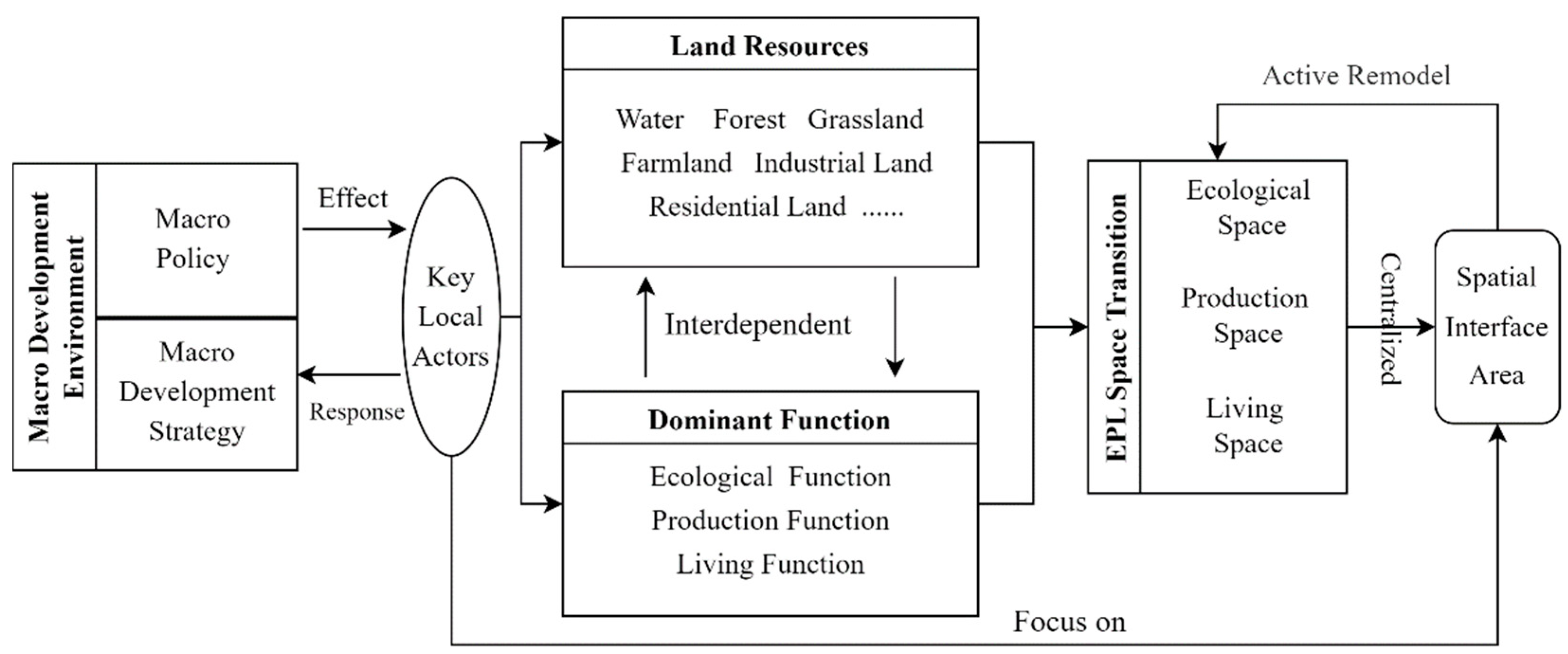
Based on the above two points, we believe that rather than analyzing the relevance of different influencing factors, it is more important to start at the practical level and focus on the conditions under which land use transition occurs, in which areas of villages it is more likely to occur, and who is behind it. Such analysis gives rise to the following questions: What are the characteristics of land use transition in micro-level villages and towns in light of changes in macro-level factors? How are macro-level factors transmitted to the micro-level case area, and how do they influence land use transition within an area? What are the endogenous factors that cause land use transition to occur within the micro-level region?
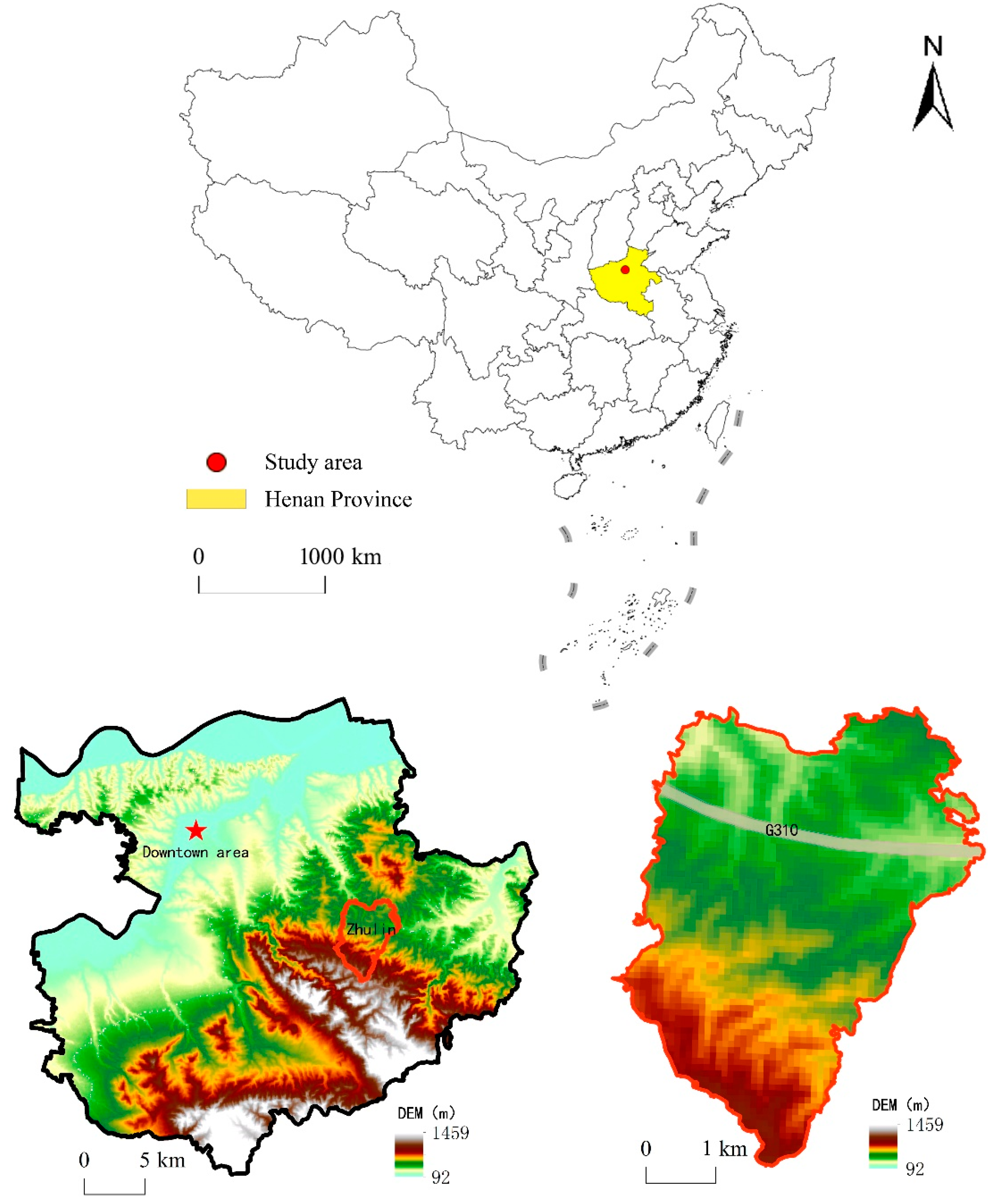
In light of such questions, the main purpose of our study was to explore the characteristics of the restructuring of ecology–production–living (EPL) spaces at the micro-level of villages and towns from the perspective of land use change. It also focused on the micro-scale endogenous driving mode of land use transformation and explored the possibility of transforming the passive adaptation mode of land use transformation into an active response mode. To accomplish this, we first constructed a theoretical framework to sort out how land use transition and its driving forces take place in Chinese villages and towns in the context of macro-level policy changes. Then, through a case study of a mountain town in inland China, we investigated the characteristics of its land use transition based on long-term observation. On that basis, we studied its endogenous driving mode and explored the possibility of actively promoting land use transformation.

2. Materials and Methods

2.1. Theoretical Framework

To empirically explain land use transition, it is necessary to first clarify the research object of land use transition [48]. International scholars initially interpreted land use transformation as the change of land use form in time series [49]. Although this interpretation points out the direction for the study of land use transformation, the lack of systematic explanation of the deep-seated causes of land use transformation inevitably leads to some scholars misunderstanding the research object of land use transformation. As the steady development of the concept of land use morphology, land use transformation is further considered to include changes in land use spatial form and functional form [2,44]. Therefore, the research on land use transformation also needs to start from these two aspects. In addition, the division of EPL spaces provides an effective way to optimize China’s spatial development pattern in the context of ecological civilization construction by categorizing land use types based on dominant functions with regard to human needs. It is also a more comprehensive zoning model, which is consistent with China’s concept that ecology, production, and living form the three “pillars” of sustainable development [50]. Among them, ecological space refers to the land use system that regulates, maintains, and protects ecological security functions [51]; production space refers to the land use system that provides a material space carrier for human production and operation activities [52]; and living space is a land use system that carries and protects human settlements and carries out social activities [51]. An EPL-based land use classification system can comprehensively reflect changes in the spatial and functional forms of rural land use. Therefore, land use types were categorized into EPL spaces in this study.
Land use transition research aims to explore how to better manage land resources and achieve sustainable development. Generally speaking, the process of land use transformation is a “conflict coordination” process [48], which refers to the process of regional land use form transformation corresponding to the transformation of economic and social development stages, within a period of time, driven by economic and social changes and innovation. In general, regional economic and social changes and innovations require changing the current land use patterns, promoting the transformation of land use, and then achieving the transformation of regional development goals. In macro-scale case studies, we usually first recognize the negative ecological environmental effects caused by land use change owing to economic and social changes, and then seek to regulate through the land resource management system to guide land use transformation. Under this framework, analyzing the quantity and structure of land use transformation can help us understand the current trend of macro-scale land use transformation and adjust the corresponding policies in a timely manner to solve the problems. The regulation of land use transformation is based on the coupling of its distribution pattern and transformation process [48]. The influence of pattern and process is mutual. Through the research on the coupling mechanism of man–land interaction, we can diagnose whether the factors that affect the structural effect of the system mainly come from natural processes or human processes, and adjust engineering and technical measures or policy measures to regulate land use transformation, so that the land system can stably play its expected functions, and ultimately promote the completion of land use transformation. At the micro-scale level of villages and towns, to minimize the negative effects of this passive response process, in addition to understanding the characteristics of the structure and amount of land use transformation, it is necessary to explore the sensitive areas of land use change in the process of macroeconomic and social environment change and understand the deep mechanism of its transformation, which will enable us to better understand the underlying logic of its transformation. Then, the process of passive response can be transformed into a process of active adaptation to actual intervention in land use transformation can be carried out in advance.
Spatial interface theory provides a new perspective for studying spatial location. The interface is derived from the theory of system science and refers to the intersection of two systems [53]. Geographers put forward the theory of spatial interface with the spatial system as the research object [54]. According to the theory of spatial interface, the spatial interface is the most active area in the flow of goods, energy, and information between the two systems. It consists of intersecting heterogeneous systems. Thus, the landscape composition and activity mechanisms at the spatial interface are highly heterogeneous compared to the internal system. The landscape characteristics and activity mechanisms at the spatial interface often reflect the transitional characteristics between the two heterogeneous systems. Because of such characteristics, the elements in a region are constantly reorganized, and the degree of development between regions is constantly differentiated, resulting in the spatial differentiation of various geographical phenomena. Various studies have used spatial interface theory to interpret spatial differences in urban–rural development, rurality, poverty, and county-level economies [54,55,56]. We propose, therefore, that land use transition in a micro-level region may be concentrated in its spatial interface region, and this region presents the possibility of further optimizing land use transition.
Unlike a simple land use change scenario, land use transition reflects not the transformation of a single parcel but a trend of transformation [42]. Many natural and socioeconomic factors influence land use transition, but the most important factor is who brings land use transition to fruition. The possibility and extent of being transformed under existing socioeconomic and ecological conditions, as well as policy, regulatory, and engineering environments, are key to determining the optimization of land use transition [57]. Since China’s land system is based on public ownership, national and regional development strategies and policies determine the direction and mode of land use transition. For micro-level regions, however, macro-level policies and development strategies are not controllable, and the extent to which villages and towns respond to national-level policies and development strategies becomes key to driving land use transition in those regions.
In light of the above, we developed a research framework to formulate our hypothesis (Figure 1)—namely, that key local actors contribute to the interplay between land resources and dominant land functions in villages and towns under the influence of macro-level policies and development strategies, thus contributing to the transition and restructuring of local EPL spaces. The spatial interface area in the rural regional system may be the sensitive area of land use transformation. Understanding the characteristics of the space interface area will help us actively adapt to changes in the external environment and further actively reshape and guide the transformation direction of EPL space.

2.2. Study Area

Zhulin is a town that developed from a village into a town over the past 20 years. It is located in Henan Province in inland China in a transitional zone of mountains and hills (Figure 2). The total area of Zhulin is about 20 km2. In 2019, the permanent population of the town was 21,000, the total social output value was CNY 10 billion, tax revenue was CNY 300 million, and per capita income was CNY 40,300.
In the more than 40 years since China’s “reform and opening up”, Zhulin has been one of the few inland mountain villages to evolve from a small, distant village with no industry into a modern town focused on industry and tourism development. Moreover,, as a pilot town for sustainable development in China established by the UNDP, it has won the Dubai International Award for the best example of an improved living environment established by UN-Habitat. Therefore, Zhulin can be considered a good research case. Its development process represents the concentrated process of rural development in China. Studying land use transformation in Zhulin and the related factors of its development process can have strong implications for guiding the revitalization of other villages with similar development conditions.

2.3. Data Sources

The land use data for this study came from a long-term in-depth survey of Zhulin taking place since 2016, from which we obtained village- and town-level archives for the past 30 years and digitized the key information. Owing to a lack of early remote-sensing images, data for land use in 1990 and 1995 were obtained by digitizing hand-drawn maps in the village archives of Zhulin. Data for 2005 came from a land use map provided by the Natural Resources and Planning Bureau of Gongyi. Data for 2010 came from the current land use map of the general plan of Zhulin prepared that year, and data for 2019 came from satellite images obtained using Google Earth. These data were then proofread by the spatial matching of important markers. Then, to capture the historical land use situation and match it with the abovementioned maps, we invited old village cadres, current town leaders, and others who had experienced the complete development of Zhulin to help record the construction of and changes in important surface structures, roads, and facilities. Meanwhile, elevation-related data involved in the functional suitability analysis were extracted from 30 m precision TM remote-sensing images provided by the National Earth System Science Data Sharing Infrastructure, National Science and Technology Infrastructure of China—Data Center of the Lower Yellow River Regions.

2.4. Research Methods

2.4.1. EPL Space Identification and Classification

For the division of EPL space, we need to consider not only the natural attributes of land but also the subjective intentions of land users [58]. In EPL, ecological space plays a role in regulating, maintaining, and protecting ecological security in the land use system [51]. Production space plays the role of providing a material space carrier for human production and operation activities in the land use system [52]. Lastly, living space plays a role in carrying and protecting human settlements and carrying out social activities in the land use system [51]. Two models are commonly used to identify and classify EPL spaces. The first is the index system measurement algorithm, which chiefly identifies EPL spaces by building a multiple evaluation indicator system [59]. Given the need for a large number of complex indicators, this method is often used to study meso- and macro-level scales. The second approach is spatial subsumption based on land use type [60]. For the relatively micro-level scale of villages and towns, it is difficult to obtain complex, diverse indicators over a long period of time. The second approach can enable us to quickly identify the spatial distribution of land use space and reflect the function of land. Based on this, we identified the number and distribution of EPL spaces based on China’s Current Land Use Classification (GB/T21010-2017) and Town Planning Standards (GB50188-2007), combined with the actual situation in Zhulin. It is important to note that production space includes land for not only primary industry carrying agricultural production activities but also secondary and tertiary industries carrying non-agricultural activities [50]. There is a clear distinction between agricultural space and non-agricultural space in terms of functional suitability [60]. Therefore, we further divided production space into agricultural production space and non-agricultural production space (Table 1).

2.4.2. Identification and Determination of the Interface

According to the principle of interface formation, a system that can form an interface must be subordinate to a larger system such that the two have some commonalities. No interface will be formed between two completely unrelated systems. The elements of the natural system and the human system interact with each other. The human system constantly demands materials and energy from the natural system through the boundary gate, and mutual information exchange is conducted to meet the needs of human survival, such as food, clothing, housing, and transportation. At the same time, after information about the human transformation of nature is received by the natural system, the natural system will establish a new ecological balance by adjusting its own functions and mechanisms. Thus, we can infer that there are many interfaces in the rural regional system, which can separate natural system elements from human system elements.
This study used the moving split window technique to quantitatively identify the position of the spatial interface; Figure 3 shows its principle. This technique was first proposed by ecologists [61] and used to analyze the location of ecotone and determine the influence area of landscape interfaces. This technology has been shown to be an effective method for judging the impact area of an ecological interface [62]. Since an ecological interface and a spatial interface are essentially the same—that is, they are both interfaces of different systems—we aimed to use this method to identify the position of the spatial interface.
In this method, first, a window containing an even number of sample points is selected and divided into two halves. Then, the dissimilarity coefficient between the two halves is calculated. We used the common squared Euclidean distance (SED) method to measure the dissimilarity coefficient between windows [62]. The formula is as follows:
S E D n = i = 1 m ( X ¯ i a w X ¯ i b w ) 2
where SEDn is the squared Euclidean distance when the window is n, and X ¯ i a w and X ¯ i b w represent the average values of the A and B half-windows, respectively, when the parameter is i.

2.4.3. Characteristics of Land Use Transfer in the Spatial Interface

We used the concept of location entropy to determine whether land use transition change characteristics were concentrated at the spatial interface. As an indicator reflecting the dominance of a certain element in a certain region, location entropy can reflect the concentration of that element in a certain time period. The formula is as follows:
L U Q a = x i a / X i S a / S
where LUQai is the land use transfer locality at the spatial interface, indicating whether i land use transfer direction at the a spatial interface has concentration dominance in the current period. xia indicates the transfer amount of i land use transfer directions at the a spatial interface, and Xi indicates the total transfer amount of land use transfer directions in i in the current period. Sa indicates the total area of the a spatial interface in the current period, and S indicates the total area of the study area in the current period. When LUQai < 1, it means this type of land use transfer direction is not concentrated at the a spatial interface; when LUQai = 1, it means this type of land use transfer direction is at the average level of the whole area; when LUQai > 1, it means this type of land use transfer direction is concentrated at the a spatial interface. The larger the LUQai, the greater the concentration dominance.

3. Results

3.1. Spatial Transfer Characteristics of EPL Spaces in Zhulin

3.1.1. Overall Distribution of EPL Spaces in Zhulin

In the process of Zhulin’s development, not only has its leading industry changed, but its administrative area has expanded as well. This has led to a dramatic restructuring of the EPL space in Zhulin. To reflect the distribution structure of EPL space in Zhulin in different periods, we took 1990, 1995, 2005, 2010, and 2019 as time nodes and analyzed the transformation process of EPL space (Figure 4). In addition to the availability of data, we chose these time nodes because they are representative. Before 1994, Zhulin was only a village, not a town, so we chose 1990 to represent this period. In 1994, the administrative authority of Zhulin was changed from village to town, and its administrative area was expanded from 4.2 km2 to 6.4 km2. Therefore, we selected 1995 to reflect the early days of the establishment of Zhulin as a town. In 2006 and 2012, the administrative jurisdiction of Zhulin was expanded by 10.05 km2 and 10.15 km2, respectively, on the original basis. Therefore, we chose 2005 and 2010 as time nodes to reflect the time before the change in Zhulin’s administrative regions. In addition, we used 2019 to reflect the current time in Zhulin.
In general, the distribution of EPL spaces in Zhulin shifted from the initial cross-distribution of ecological, production, and living spaces to a relatively concentrated distribution. Ecological space was increasingly concentrated in the south, agricultural production space was increasingly concentrated in the north, and non-agricultural production and living space was concentrated in the central area, with an obvious trend of distribution along roads.

3.1.2. Transition and Restructuring of Zhulin’s EPL Spaces

The changes in administrative area create certain disturbances for studying land use transition. If calculations were only based on the total amount, then the new EPL spaces, owing to changes in the administrative area, would interfere with the study. The purpose of this study was to investigate the endogenous factors of land use transition in the case area; thus, it was necessary to focus more on the various types of spatial transition changes in the region. Accordingly, we took the administrative area of the initial year as the study area for land use transfer between different years to study transfers within it. For example, the transfer matrix for the period 1990–1995 indicated the amount of EPL spatial transfer within the administrative area of 1990 during the period 1990–1995.
The general characteristics of the 1990–1995 period included the continuous shrinkage of agricultural production space, the rapid growth of non-agricultural production space, and the continuous expansion of ecological space and living space (Table 2). The largest increase was in ecological space, which increased by 23.6 hm2. The highest percentage of increase was in non-agricultural production space, which increased by 31.33%, among which the highest percentage was transferred from ecological space to non-agricultural production space, accounting for 55.97% of the total transfer of non-agricultural production space, followed by agricultural production space, accounting for 32.56% of the total transfer. Both living space and ecological space were mainly transferred from agricultural production space.
The general characteristics of the 1995–2005 period included the continuous shrinkage of ecological space, while non-agricultural production space continued to grow rapidly, living space expanded rapidly, and agricultural production space was restored (Table 2). The largest increase was in agricultural production space, with an increase of 60.35 hm2, mainly from the transfer of ecological space. The highest proportion of growth was in non-agricultural production space, with an increase of about 97.93%. The proportion of transfer from ecological space to non-agricultural production space was the highest, accounting for 62.16% of the total transfer of non-agricultural production space, followed by agricultural production space, accounting for 26.29% of the total transfer. Living space was also mainly transferred from ecological space and agricultural production space, and the amount of transfer was almost the same for both.
The general characteristics between 2005 and 2010 included the recovery of ecological space, a change in the growth trend of non-agricultural production space and living space, and the adjustment and contraction of agricultural production space (Table 2). Among them, the increase in ecological space was mainly transferred from agricultural production space, accounting for 86.29% of the total transfer. The largest reduction was in agricultural production space, which decreased by 50.67 hm2 and also accounted for the highest percentage of reduction. The reduction in non-agricultural production space was mainly transferred to ecological space, and the reduction in living space was mainly transferred to agricultural production space.
Spaces continued to be integrated, non-agricultural production space resumed rapid growth, ecological space continued to expand, and living space increased slightly (Table 2). The largest increase was in ecological space, with an increase of 91.96 hm2; the highest percentage of increase was in non-agricultural production space, with an increase of about 82.82%. Non-agricultural production space, living space, and ecological space were all transferred mainly from agricultural production space.

3.2. Identification and Determination of the Spatial Interfaces of Zhulin

Spatial interfaces can be divided into two types based on the types of elements that form them: natural interfaces and human interfaces [56]. Natural interfaces mainly exist between different natural geographic systems. For a micro-level case such as Zhulin, which is in Gongyi, natural conditions such as climate, hydrology, and sunlight do not significantly vary in the region. However, because it is located in a shallow mountain area, the terrain conditions are complex, providing conditions for the emergence of its natural interface. Unlike natural interfaces, human interfaces are formed by the interaction of different artificially defined systems (e.g., administration, economy, culture, transportation). For the rural system, the development of agriculture can meet the needs of rural areas and provide resource support for urban development. In this process, the exchange of materials and energy between rural and urban areas has continued to enhance the connotation of rural production functions, thus promoting the development of rural areas [55]. In the case of Zhulin, its urban space already existed when it was transformed from an administrative village into an established town at the end of 1994. This was because, according to the Urban and Rural Planning Law of the People’s Republic of China, the town area, where the town government is located, also belongs to the urban area, and the construction land within this area belongs to urban construction land. The system it belongs to is different from the one that rural construction land and agricultural production land belong to in the surrounding rural settlements. Accordingly, we can determine that there is also a certain urban–rural interface in Zhulin, which we delineated based on the proportion of urban construction land (Table 3).
Based on this, we obtained the location distribution map of the spatial interface of Zhulin using the moving split window technique. It should be noted that compared with natural interfaces, such as relatively stable topographic conditions (Figure 5), the elements of human interfaces are relatively more active because of the continuous development of human activity. The area of urban construction land in Zhulin also changed year by year. Therefore, we extracted the location of different urban–rural interfaces based on different research periods (Figure 6).

3.3. EPL Space Transfer and Reconstruction Features at the Space Interface

3.3.1. Changes at the Terrain Interface

During 1990–2019, the area of the terrain interface expanded with the change in Zhulin’s administrative area, but its proportion of the administrative area did not change much (Figure 7). Accordingly, we obtained the location entropy of various types of spatial transfer that were within the terrain interface in different periods.
During 1990–1995, except for non-agricultural production space, several other types of space were transferred at the terrain interface. The largest transfer was from agricultural production space, and the highest location entropy of land use transfer was from ecological space to agricultural production space (2.13). This was followed by transfer from agricultural production space to living space (1.55) and ecological space (1.46) and living space to ecological space (1.04). The location entropy of every other land use transfer was less than one, indicating no advantage. We can see that the land use transfer process involving agricultural production space and ecological space was concentrated at the terrain interface during this period (Table 4).
During 1995–2005, except for non-agricultural production space, other types of space were transferred at the terrain interface. The largest transfer was to ecological space, and the highest location entropy of land use transfer was from living space to ecological space (2.33), followed by transfer from agricultural production space to ecological space (1.33). The location entropy of every other land use transfer was less than one, indicating no advantage. Considering the overall situation of land use transfer, although a shrinkage of ecological space occurred, the transfer to ecological space during this period mostly occurred at the terrain interface (Table 5).
During the period 2005–2010, all four types of spaces were transferred at the terrain interface. The largest transfer was from agricultural production space, and the highest location entropy of land use transfer was from agricultural production space to ecological space (2.06). This was followed by the transfer from ecological space to agricultural production space (1.96) and again from living space to agricultural production space (1.14). The location entropy of every other land use transfer was less than or equal to one, indicating no advantage. The interconversion of ecological space and agricultural space during this period occurred centrally at the terrain interface (Table 6).
From 2010 to 2019, all four types of space were transferred at the terrain interface, with the largest transfer being agricultural production space. The highest land use transfer location entropy was from ecological space to living space (1.45), followed by the transfer of ecological space to non-agricultural production space (1.08). The location entropy of all other types of land use transfer was less than or equal to one, indicating no advantage. During this period, with the further expansion of Zhulin’s administrative area, the terrain interface also increased greatly, but the proportion of the total area where it was located did not change much. At the same time, the transfer of ecological space and living space and non-agricultural production space occurred centrally at the terrain interface (Table 7).

3.3.2. Changes at the Urban–Rural Interface

During 1990–2019, with the continuous development of Zhulin, its urban–rural interface area also expanded, but with the continuous expansion of Zhulin’s administrative area, the ratio of the urban–rural interface area to the administrative area fluctuated (Figure 8). Accordingly, we obtained the location entropy of various types of spatial transfer that were within the urban–rural interface in different periods.
During 1990–1995, all four types of spaces were transferred at the urban–rural interface, among which the largest transfer was agricultural production space. Only the transfer of agricultural production space to ecological space and ecological space to agricultural production space had a location entropy of land use transfer lower than one. The location entropy of all other transfers was greater than one. The highest was the transfer of non-agricultural production space to agricultural production space and living space, as well as the transfer of living space to non-agricultural production space, both at 2.45. During this period, except for the mutual transfer of ecological space and agricultural production space, the mutual transfer of all other land use types occurred mainly at the urban–rural interface (Table 8).
During the period 1995–2005, all four types of space were transferred at the urban–rural interface. The largest transfer was from ecological space, and only four of the land use transfers had a location entropy below one. The location entropy of all other transfers was greater than one, the highest of which was the transfer of non-agricultural production space to living space (3.26), followed by the transfer of living space to non-agricultural production space (2.59). During this period, except for the mutual transfer of ecological space and agricultural production space, and the transfer of non-agricultural production space and living space to agricultural production space and ecological space, respectively, the mutual transfer of all other land use types occurred mainly at the urban–rural interface (Table 9).
During 2005–2010, all four types of spaces were transferred at the urban–rural interface. The absolute transfer amount of each type of space was not large compared with previous periods. The highest location entropy of land use transfer was from living space to non-agricultural production space (2.15), followed by non-agricultural production space to living space (2.15). In addition, except for the transfer of agricultural space to non-agricultural production space and living space, and living space to ecological space, all others were less than one, indicating no advantage. In this period, although the urban–rural interface area expanded, the proportion of the total area became larger, and the concentration of all other types of transfer decreased, except for the mutual transfer of non-agricultural production space and living space (Table 10).
During 2010–2019, all four types of space were transferred at the urban–rural interface, with the largest transfer being agricultural production space. The only land use transfers with a location entropy below one were the transfer of ecological space to agricultural production space and to living space. The location entropy of all other transfers was greater than one, and the highest was the transfer of non-agricultural production space to ecological space, with a location entropy of 4.74. During this period, with the large-scale increase in the administrative area, the urban–rural interface area also increased, but the proportion was greatly reduced, although most mutual transfers of land use types were again concentrated at the urban–rural interface (Table 11).

3.4. Driving Forces of Land Use Transfer

Based on our field research results, here we will try to clarify how land use transformation in the micro-level case occurred and whether there are rules to be followed in this process in space. Undoubtedly, land use transformation is always driven by key local actors under the influence of macroeconomic and social changes. The key, however, lies in who does it at the micro-level scale and what would be the most important way for them to promote land use transformation in a smooth and timely manner. In the following, therefore, we first describe how changes in macroeconomic conditions affect local land use change. Second, we clarify the measures local actors have taken to promote the transformation of land use in the region and adapt to adjustments in the external socioeconomic environment. Finally, we aim to explore and master the transformation of EPL space in the space interface to ultimately promote the construction of an active and responsive land management model.

3.4.1. Macro-Level Social and Economic Changes Are the Fundamental Cause of Land Use Transformation

The course of rural spatial restructuring in villages and towns reflects the effect of national-level shifts in rural development policy [63]. Therefore, the transition and restructuring of EPL spaces in Zhulin are essentially the result of macro-level policies and development strategies acting on village spaces.
In the 1990s, China prioritized economic development over everything else. During that time, there was no clear national-level guidance on land use, and local governments therefore set the guidelines for land use and development [64]. When Zhulin was still a village before 1994, its arable land was highly fragmented, with the largest single arable land plot having an area of only 0.67 hm2 and a per capita arable land area of only 0.05 hm2. Further, the basic conditions of arable land were poor, owing to perennial water shortages in Zhulin. As a result, villagers had low motivation to engage in agricultural production, and there were even cases of the abandonment of arable land. Some of the abandoned arable land gradually evolved from a seminatural artificial ecosystem into a natural system, restoring it to a vegetation cover state close to the natural conditions of the mountainous area. Therefore, given the more flexible national land policies of the time, and considering the actual development situation in Zhulin, Zhulin returned all small remote plots of arable land in the village to forest, restoring them to ecological space. Large plots characterized by convenient transportation became the basis for welfare construction; Zhulin would no longer have laborers specialized in agriculture, and the rations of workers and villagers would all be shared by enterprises. This is why, during 1990–1995, agricultural production space in Zhulin shrank while non-agricultural production space, living space, and ecological space all grew.
In the early twenty-first century, urbanization and industrialization led to the occupation of a great deal of arable land, a significant reduction in the rural agricultural labor force, and a decline in the efficiency of arable land production, which affected national food security. Therefore, the Ministry of Land and Resources of China launched its First Ten-Year (2001–2010) National Plan, focusing on “maintaining the dynamic balance of arable land”, to organize, reclaim, and develop idle, abandoned, and damaged land to enhance the quantity and quality of arable land [65]. These top-down policy constraints also led to the recovery of arable land area around the region during this period. Meanwhile, Zhulin reformed the local land use system in response to farmers’ low enthusiasm for cultivation. After 1996, Zhulin broke with the prior method of land contracting by individuals and implemented the unified planning, management, and administration of land by the collective, while unifying the sorting and reclamation of idle or abandoned land. At the same time, based on the principle of leading and promoting agriculture with industry, the collective village income accumulated from industry development was used to build water conservancy; purchase fertilizers, pesticides, and agricultural machinery; and promote local agricultural development. Therefore, during 1995–2005, some wasteland that had belonged to ecological space was transformed into agricultural production space, resulting in an increase in agricultural production space but a decrease in ecological space. With the unification of land use rights and the construction of industrial parks, non-agricultural production space continued to grow at a high rate.
In the early stages of China’s reform and opening up, rural industrialization, represented by township enterprises, made great contributions to the economic development of rural China, but in the twenty-first century, its drawbacks gradually emerged. Rural industrialization led to conflicts in some areas among people and between people and the government over land and labor commodification, causing great damage to resources and the environment [66]. In response, the New Rural Development Strategy was launched in 2006, expanding the previous focus on economic development to include social development and livability. This marked a shift in rural policy from the earlier structural adjustment strategy, which aimed to stimulate private enterprise, to a broader focus on social, economic, and environmental improvement [22]. In light of this shift in national strategy, Zhulin’s leaders proposed a development strategy aiming to consolidate the original primary and secondary industries while relying on local ecological resources to develop tourism and drive tertiary industry development. To this end, Zhulin relied on funds accumulated from industrial development and carried out environmental improvement projects. Formerly scattered settlements were relocated to the township following the principle of continuous development and centralized living. The project of returning farmland to forests was promoted, and the ecological restoration of the mining area was advanced. As a result, between 2005 and 2010, only the area of ecological space increased, the environment continued to recover, and non-agricultural production, living, and agricultural spaces began to adjust and contract.
The construction of new rural areas has, to a certain extent, alleviated the problems of rural development in China. At the same time, however, the environmental problems brought about by rapid urbanization have become increasingly prominent. The expansion of construction land has led to landscape fragmentation, environmental degradation, and the destruction of ecosystem service functions [36]. Faced with such challenges, since 2012, China has shifted from a production-space orientation to coordinated EPL to optimize the spatial layout of land and alleviate the contradiction between urban and rural development [58]. Against this background, Zhulin established a development strategy to strengthen industry, revive the town through tourism, and develop primary, secondary, and tertiary industry in a coordinated way. Relying on its original system of unified land management, Zhulin further improved the concentration of land and promoted the integration of various types of spaces. As a result, during the period 2010–2019, non-agricultural production space and living space resumed growth, and ecological space continued to be restored.

3.4.2. Autonomous Spatial Governance Capability of Villagers’ Self-Organized Institutions Is Key to Regulating Land Use Transformation

In China, the system of grassroots-level democratic autonomy affects the implementation of national policies in individual villages [67]. Village bodies elected through this self-governance system are the most important actors in the transition of rural land use. The Organic Law of the Villager Committees of the People’s Republic of China stipulates that village committees use self-governance mechanisms to manage land contracting issues; this allows villages to redistribute land according to their own rules [68]. However, this process must interact with national-level policies and regional development plans while adapting to local development conditions. Therefore, under the influence of autonomous grassroots rural policy, the impact of changes in external macro-level national or regional policies and the market environment on village development is determined by village-elected organizations’ awareness of such changes [69]. In the interactive coupling process of land use and rural development, the villagers’ autonomous self-organization is the key driver of rural land use transformation.
Although self-organizing grassroots village institutions are the key enablers, it is their autonomous spatial governance capacity that is the key guarantee for promoting the transition of rural land use. The essence of rural spatial governance is the management of the village’s public affairs. As part of public management in rural areas, rural spatial governance needs an authoritative body to overcome the dilemma of collective action in the optimization and adjustment of EPL spaces. In addition, a large amount of construction funding is needed to realize the optimal adjustment of EPL spaces. The authoritative body is a governance actor while funding is a governance resource; the two constitute the capacity to govern rural space [70]. If both are dominated by external authorities, village autonomy in the governance of rural space will be lost. Therefore, autonomous rural spatial governance capacity that satisfies local rural development aspirations while ensuring that actions are implemented is the critical guarantee of rural land use transition. This process can be achieved through an endogenous village-elected authority [67]. Compared with external authority, endogenous authority, which is “born” and “grown” in the village, is formed by the spontaneous order of the village society and “filtered” by village values. Endogenous authority is not only grassroots and public, but it also possesses rich local knowledge. As the main actor in autonomous spatial village governance, endogenous authority can organize and mobilize farmers, integrate various resources inside and outside the village, coordinate and balance interests within the village, and promote spatial village governance in an orderly manner. Moreover, measures are needed to limit the power of the endogenous authority to prevent abuses of power.
Zhulin can adjust the development mode of the region in a timely manner along with shifts in national policy. It can benefit from its good self-organization innovation mechanism, which is also key to its ability to ensure independent spatial governance. The spatial restructuring of Zhulin over the past 30 years has fit well with the national policy shift. This is not an easy task for local governments, and such adjustment is the main reason for the sustainability of Zhulin’s social and economic development. Under the framework of grassroots autonomy in China, Zhulin can also adjust in a timely manner the management system of the village collective. Since 1990, bamboo forest management has broken away from the original management system of the administrative villages and has explored the self-organized system of village management through enterprises. The 13 natural villages belonging to the town were attached to the village’s eight general factories. With industry promoting agriculture, Zhulin was able to improve the efficiency of the collective management of the village, thus promoting the efficiency of enterprise production and operation and guiding enterprises to transform from a labor-intensive orientation to a technology-intensive one.
After the establishment of the town, and with the support of the city and provincial governments, Zhulin explored the management system of an “autonomous town.” After the town’s establishment, only the village-level management committee was upgraded to the Zhulin Management Committee. This was still essentially a collective economic structure, with popularly elected, popularly owned, and autonomous characteristics, given the responsibility of managing Zhulin by the higher government and entrusted with exercising administrative power. The “three no’s” policy—namely, no fixed staff, no fixed cadres, and no fixed institutions—was implemented. In this way, Zhulin pioneered a new style of small-town “self-governance” in China, effectively avoiding “Parkinson’s law” in which administrative agencies and personnel form a vicious circle. For more than a decade, Zhulin maintained this low-cost, high-efficiency, people-owned, people-governed management system.
Then, in 2001, with China’s accession to the World Trade Organization, the reform of China’s socialist market economy continued to advance, and Zhulin’s model, which unified government and enterprises, could not adapt to the times. Therefore, Zhulin’s government adopted reform measures to withdraw from all areas of enterprise management and operation. Each neighborhood committee, as a subordinate body, was only responsible for social and public welfare work. Enterprises had complete autonomy, and government functions shifted toward public services, thus creating conditions for the development of Zhulin’s enterprises again.
Furthermore, Zhulin has explored a supervision and management system that allows villagers to easily understand the combination of top-down and bottom-up management, ensuring that its rural autonomous spatial governance capacity can continue to operate on the right track. This model is referred to as the “San Ping” and “Shi Ping” governance model. “San Ping” refers to a bottom-up procedure by which villagers can evaluate the governance work of village leaders and cadres, bringing into play a mass supervision mechanism. “Shi Ping” refers to a performance evaluation of the masses to motivate their contribution to Zhulin’s development. This supervision and management system can mobilize grassroots participation in politics and promote a unified perspective. It enables local actors to grasp development opportunities and correct problems in the development process in a timely manner, thus promoting the high-quality development of Zhulin.

3.4.3. Spatial Interface Is a Sensitive Area for Land Use Transformation in a Natural State

Our case study of Zhulin supported the hypothesis that the spatial interface is more sensitive than other areas in the context of external environmental changes, and it is where the process of land use transition is concentrated. As the spatial intersection of two systems, the spatial interface is the most active area for the flow of goods, energy, and information between the two systems [55]. Given the complexity of its activities and the frequency of energy and materials exchange, among others, the spatial interface often exhibits multiple effects, such as edge, skin, additive, and scale effects. Under the influence of such effects, the original stable state between regions is broken, and elements in the region are constantly reorganized by absorbing the external inflow of materials, energy, and information, leading to differentiated development between regions and the spatial differentiation of various geographical phenomena. The spatial interface is also the area where the heterogeneity of geographical elements is most obvious. Therefore, in the context of external environmental changes, the spatial interface area is more sensitive than other areas and more prone to land use transition. The process of land use transition involving ecological space—especially the mutual transition of ecological space and agricultural production space—is mainly concentrated at the terrain interface. As the macroenvironment of China’s economic development has continued to change, Zhulin has also continuously adjusted its development strategies and goals under the leadership of its village organizations. In terms of agricultural production space and ecological space, Zhulin has experienced the neglect of agricultural production, the return of farmland to forest and grass to ensure food security, the integration of wasteland for agricultural production, environmental improvement and the construction of new rural areas, tourism development, ecological restoration, and the concentration of agricultural production space. These processes are manifested in the transformation of agricultural production space and ecological space. At the village and town scale, this process can be understood as the allocation of land resources by local actors to maximize their own interests under the constraints of specific macro and local institutional and economic factors.
Zhulin is located in a shallow hilly area with a high topography in the south, interspersed with mountains and valleys, a relatively low topography in the north, and a slightly larger area of flat terraces. Like most villages in mountainous areas, many villagers in the early stages of Zhulin’s development were scattered among the mountains, valleys, and terraces, and geographically these areas had both mountainous and plain elements, which in essence comprised the terrain interface of Zhulin. Villagers would rely on the favorable terrain to carry out agricultural production, thus creating a highly fragmented agricultural production space in the early period. Therefore, compared with the pure mountainous area in the south and relatively flat terrace in the north, the region is intertwined with the ecological space and agricultural production space. This provided the basis for the interconversion of ecological and agricultural production spaces. To meet the requirements of changing external development conditions (e.g., the requirements to return farmland to forest and integrate wasteland for agricultural production), for a town such as Zhulin, where non-agricultural production was the main focus and villagers were not motivated toward agricultural production, it was more beneficial to transform ecological and agricultural production space in the terrain interface area to maximize benefits. This is in contrast to the northern area, which has better topographic conditions and is more suitable for large-scale non-agricultural production, as well as the purely mountainous area in the south, where transportation is less convenient and conversion costs are relatively higher. Therefore, compared with the non-terrain interface in the northern terrace area and the purely mountainous area in the south, the transformation of ecological space and agricultural production space was mostly concentrated in the terrain interface area.
Compared with the terrain interface, the spatial transfer of EPL spaces was more active at the urban–rural interface. In particular, the process of land use transition involving non-agricultural production space and living space was almost always concentrated at the urban–rural interface. This is mainly because the non-agricultural production space, primarily used by industrial enterprises, which comprise the most important production sector in Zhulin, generally exists in specific areas that are favorable for the concentration of industrial factors. Compared with rural areas, the urban–rural interface has a well-developed transportation network and is close to urban consumption centers, making it easy to form geographical connections with external markets and take advantage of urban capital, materials, management, information, human resources, and technology to attract a large number of industrial enterprises. These are mostly distributed like a belt at the urban–rural interface, aiming to utilize both urban resources and the excellent environment of the countryside. The living space, which is mainly rural living space, is mostly concentrated in the area with high economic activity. The urban–rural interface of Zhulin is rich in industrial enterprises, making the area an intersection of logistics, energy flow, and information flow, with frequent economic activity at various levels. Therefore, in the urban–rural interface area, the actors have better access and more development opportunities, and the living space is also concentrated in this area. As non-agricultural production space and living space continue to concentrate at the urban–rural interface, the urban attributes of the area continue to increase, and urban space continues to expand outward, resulting in a larger urban–rural interface. In this process, the ecological and agricultural production spaces originally belonging to the surrounding rural areas are continuously transferred to non-agricultural production and living spaces. As a result, most land use transition processes involving non-agricultural production space and living space are concentrated at the urban–rural interface, where more land use transfer processes are concentrated.

4. Discussion

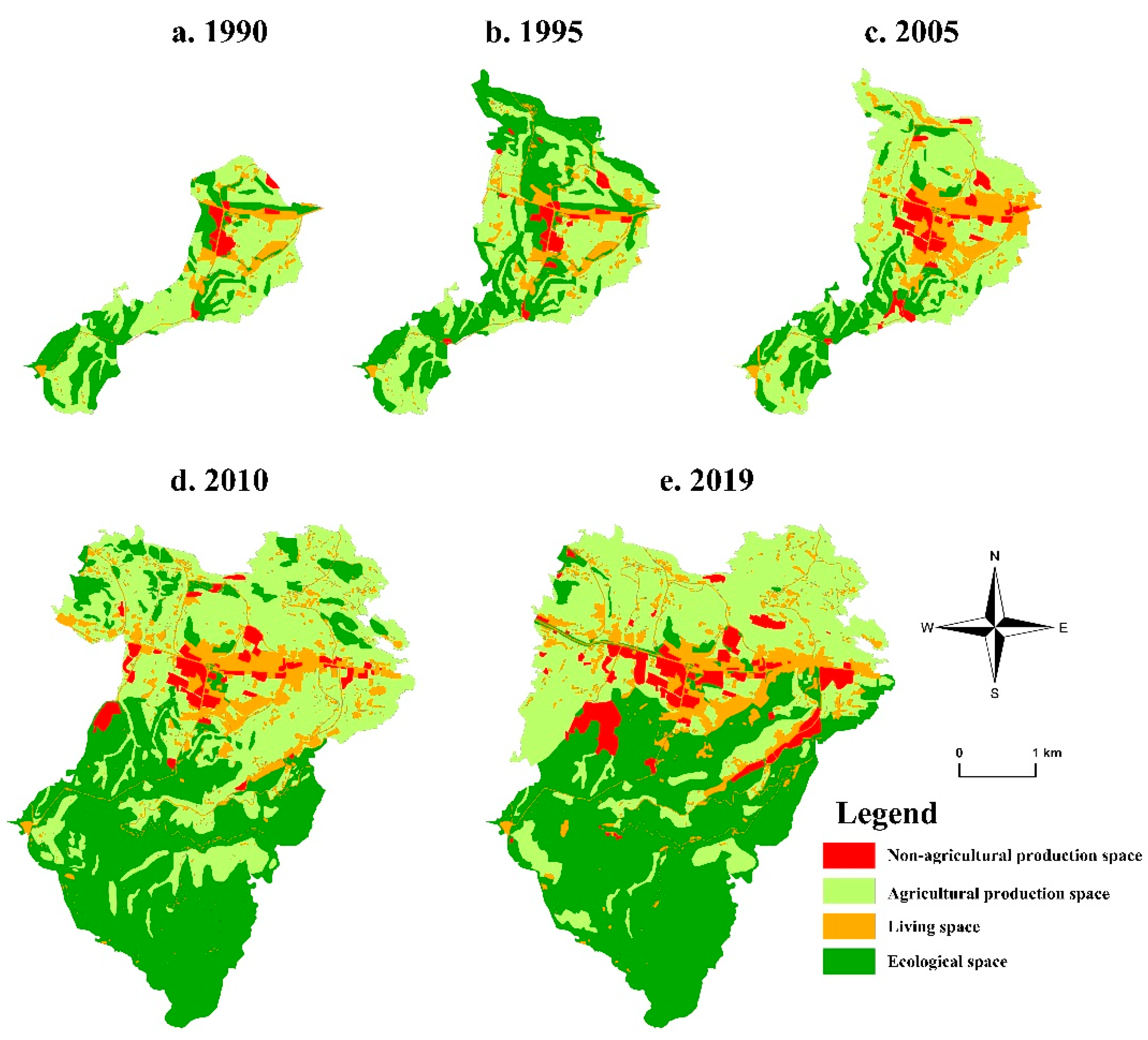
This study examined the characteristics and endogenous dynamics of the spatial transition and restructuring of EPL spaces in a well-developed village- and town-level case study in Central China over a 30-year period. This enabled us to understand how a village, in a macro-level development context, was able to transition its land use patterns to meet the development needs of the times.
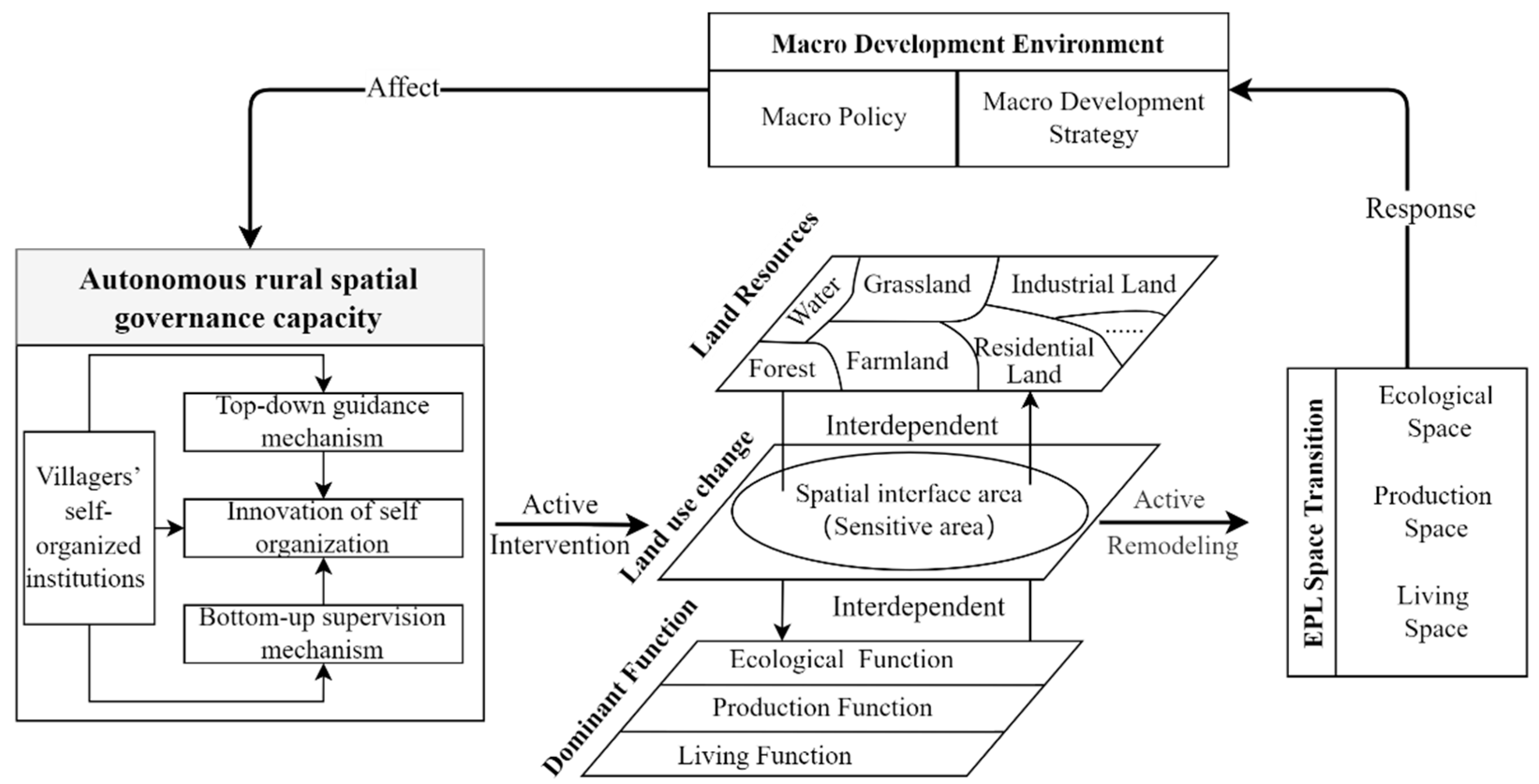
Based on our research results, we can summarize the endogenous driving mode of land use transformation in micro-level villages and towns. Under economic globalization and social modernization, China’s socioeconomic conditions are constantly changing, triggering the transformation of rural industries. As a result, the economic importance of land as agricultural land will continue to decline while the spatial carrying function and asset capital function will be enhanced, which will eventually return to agricultural production and ecological landscape functions and tend toward stability. This trend will also be mapped to land use form changes. Our study shows that, because the spatial interface is highly sensitive to land use transformation, according to macroeconomic changes combined with spatial interface characteristics, we can undertake precautions and timely, reasonable interventions to adjust the land use pattern before the problem worsens and readapt to development needs. This process can only occur smoothly under the guarantee of villagers’ self-organization with self-innovation abilities, through the top-down, bottom-up supervision mechanism and a strong ability to govern autonomous rural space. After the reconstruction of the three living spaces of each micro-level case, it is bound to feed back to the macro-level socioeconomic environment, promote further changes in it from the bottom up, and then enter a new cycle (Figure 9).
Compared with the existing macro-scale studies, the micro-scale case studies can enable us to distinguish the rural and urban land in the macro-region, so that we can more accurately study the process and driving mechanism of rural land use transformation, and then reveal the root of rural development and the actual problems faced. On the one hand, as a mountain town, Zhulin Town’s land use transformation trend conforms to the overall trend of China’s mountain land use transformation. That is, in the process of China’s transformation from an agricultural society to an industrialized and urbanized society, China’s mountainous rural areas have shown a trend turning in the long-term change of land use patterns. Rural land use in mountainous areas has evolved from farmland expansion and forest land contraction in agricultural society to farmland integration and forest land restoration growth in the process of urbanization [71]. On the other hand, we can further reveal the spatial law and endogenous driving force of the land use transformation process in mountainous villages through micro research. That is, the spatial interface is a sensitive area for land use transformation in the natural state, and the autonomous spatial governance capability of villagers’ self-organization institutions is the key to regulating land use transformation. This provides us with a theoretical basis for further and more accurate regulation of rural land use transformation. From this point of view, we think the aspects outlined below are worthy of further discussion.

4.1. How Key Rural Actors Should Guide the Transformation and Reconstruction of Rural Land Use

In contrast to previous studies, our case study of Zhulin confirmed the significance of the effects of macro-level land use policies on land use transition in rural China [37]. Owing to China’s land management system, land use transition is somewhat volatile and unstable [35]. There tend to be reciprocal transformations in the expansion and contraction of certain land use types, and such transformations are sometimes slow and sometimes fast. This is also evidenced by the process of EPL space transition in Zhulin, where development strategies were constantly adjusted because of changes in the policy environment. This, in turn, led to reciprocal transformations among EPL spaces, especially agricultural production space and ecological space.
At the same time, based on long-term tracking and research on micro-level case areas, we found that through effective local management measures, national policies can be better implemented in bamboo forests to adjust local development strategies in a timely manner and also meet macro-level development conditions. This can promote the transformation of local land use in a direction more conducive to the macro-level development environment. We can see that in the interactive coupling process of land use and rural development, grassroots villager organizations are the key actors, and rural autonomous spatial governance capacity is a key guarantee for the rational intervention and dynamic response of local actors. Furthermore, we should give play to the advantages of this grassroots system through the top-down, bottom-up operation supervision mechanism and promote villagers’ self-organized institutions to constantly self-innovate. Only in this way can we effectively give play to the strong governance capacity of rural autonomous space and thus ensure the continuous optimization and reconstruction of rural land use transformation.

4.2. Should We Passively Adapt or Proactively Respond?

Conventional research suggests that the effects of socioeconomic changes and innovation caused by land use transformation on resources and the environment directly affect natural systems, usually in a negative way. When such problems are serious enough to attract the attention of the public and governments, the management system might affect the behavior of land users through land resource management regulations, thereby directly or indirectly adjusting the economic system of land use and controlling land use transformation [13]. This process will inevitably face the negative consequences for regional development arising from the incompatibility between land use and economic and social development. If such negative effects are not corrected in time, regional development will likely stagnate or even decline. Although strong rural autonomous spatial governance capacity can intervene and adjust in a timely manner when problems are identified, it will also have a certain negative impact. Therefore, turning passive adaptation into active response and intervening ahead of time will enable us to reduce the negative effects produced by the transformation process as much as possible. By introducing the perspective of spatial interface, this study confirmed that the spatial interface area is a sensitive area in the process of land use transformation, and changes in land use patterns caused by changes in the external macroeconomic environment are mainly concentrated in the spatial interface area. Changing from a passive to an active mode of responding to land use transformation requires having independent spatial governance ability to ensure the optimization and reconstruction of rural land use transformation, as well as being able to grasp the characteristics of land use transformation. This can effectively avoid the negative effects of land use changes arising from changes in the macro-level social and economic environment caused by local actors and further put rural development on the right track.

4.3. Limitations and Research Prospects

This study has some limitations. Although the study of micro-scale can reveal its inherent differences, the representativeness of the study may be slightly insufficient. Each village has unique features in its development, especially in a large country such as China, where there are huge differences in natural, economic, and social conditions. Therefore, using a single typical village/town in China as a case study will have the limitation of insufficient representation. This was unavoidable. However, while our selected case does not represent all villages, it can at least provide some guidance value for villages with similar bamboo forest development conditions. Therefore, we believe the study is still meaningful. In the future, we will conduct in-depth research on more case areas and also make comparisons with macro-level research in the same period to further improve the universality of this driving mode.
We also recognize that our micro-level case study of Zhulin reveals a dynamic that differs from land use transition at the macro level in China. China’s government has issued many policies intended to mitigate the destruction of arable and ecological land, as well as the disorderly expansion of construction land. While these have, to some degree, alleviated the contradiction between humans and land in certain areas, they have failed to fully achieve the expected results because of ongoing land use imbalances in rural areas [37]. This is mainly because regional rural development patterns and land use patterns have not aligned with changes in development conditions as a result of actions taken by key local actors [11]. This, in turn, leads to inadequacies and imbalances in rural land use transition [35]. We can see that a good governance system is conducive to promoting the transmission of national development strategies, improving spatial development and utilization, promoting the sustainable use of space, and achieving sustainable development. On the contrary, it can also lead to the unsustainable development and utilization of space, thus weakening national governance capacity, offsetting the elasticity of spatial governance, and causing systematic governance obstacles. In the future, therefore, it will be worth investigating how to improve the rural governance capacity of key local actors in different regions and at different levels.

5. Conclusions

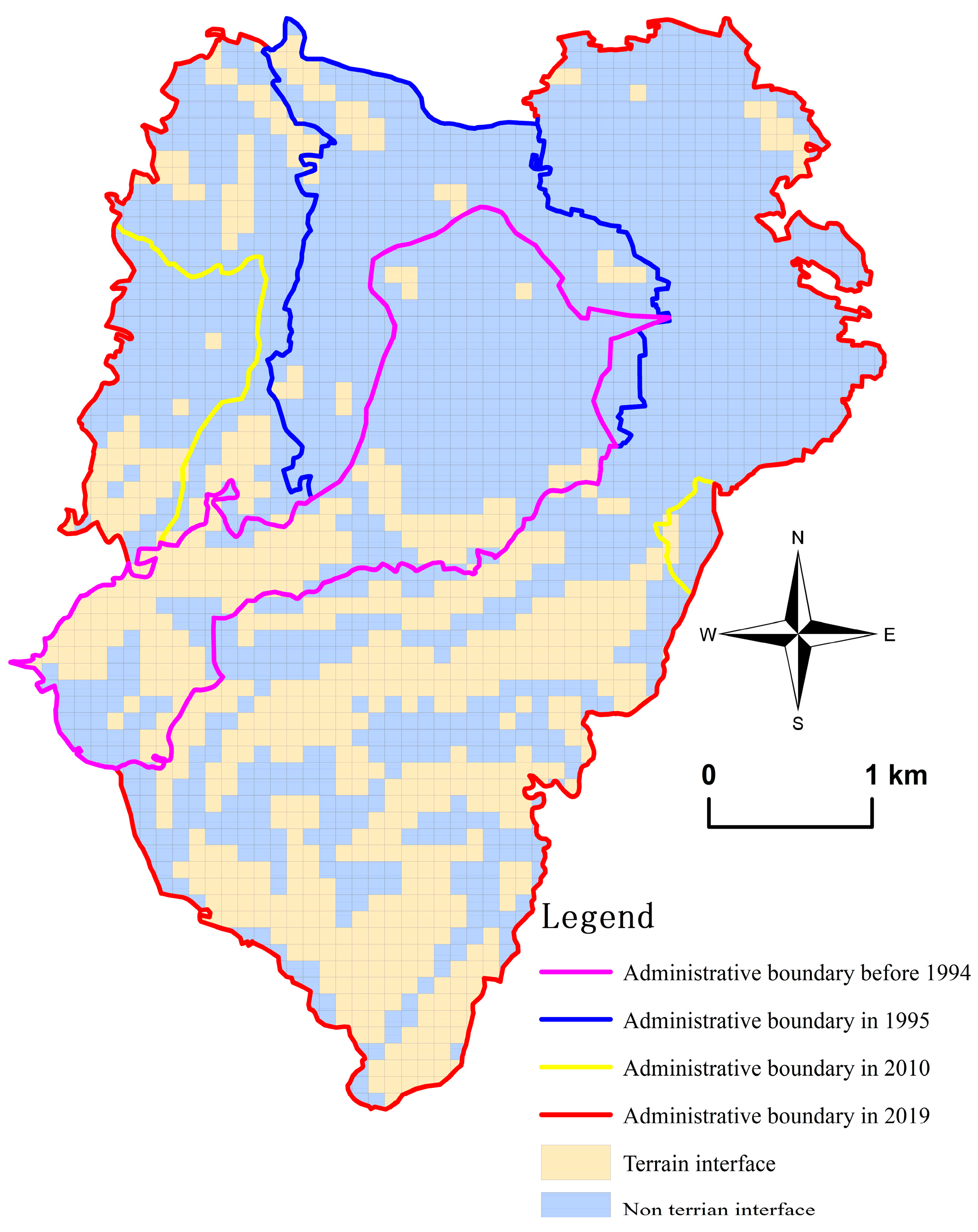
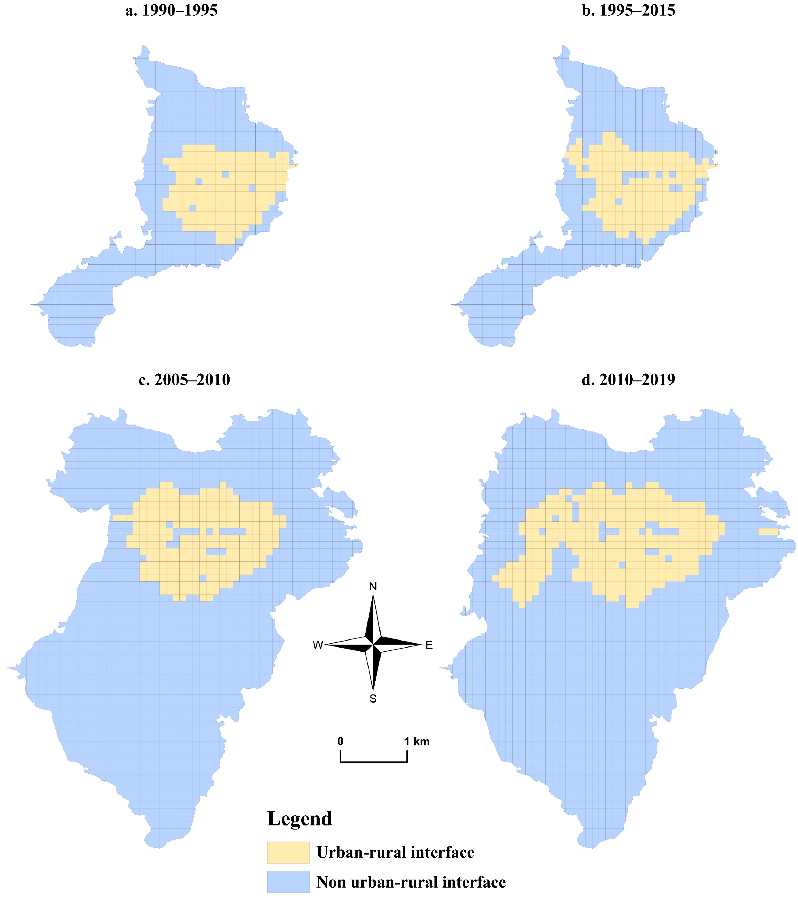
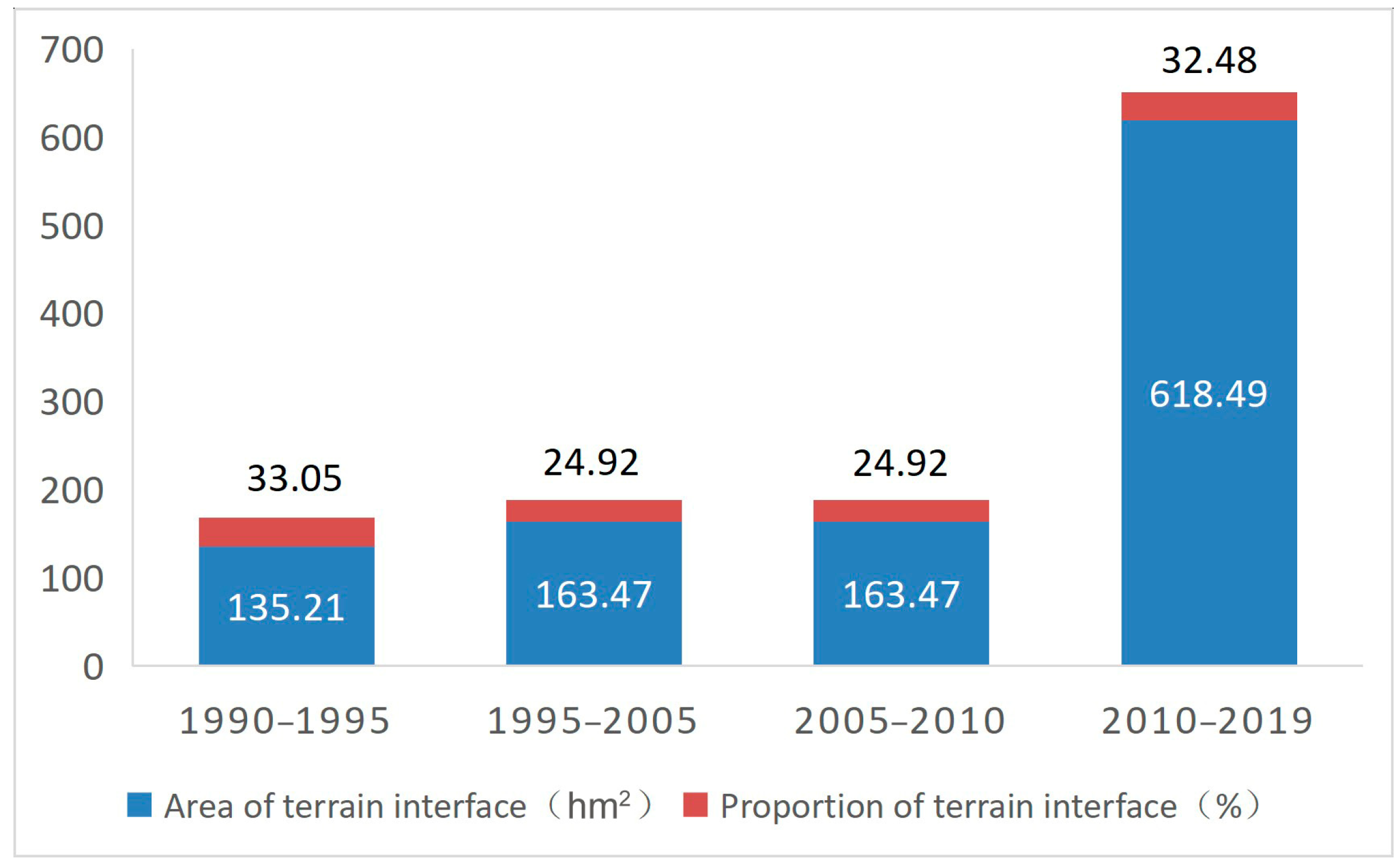
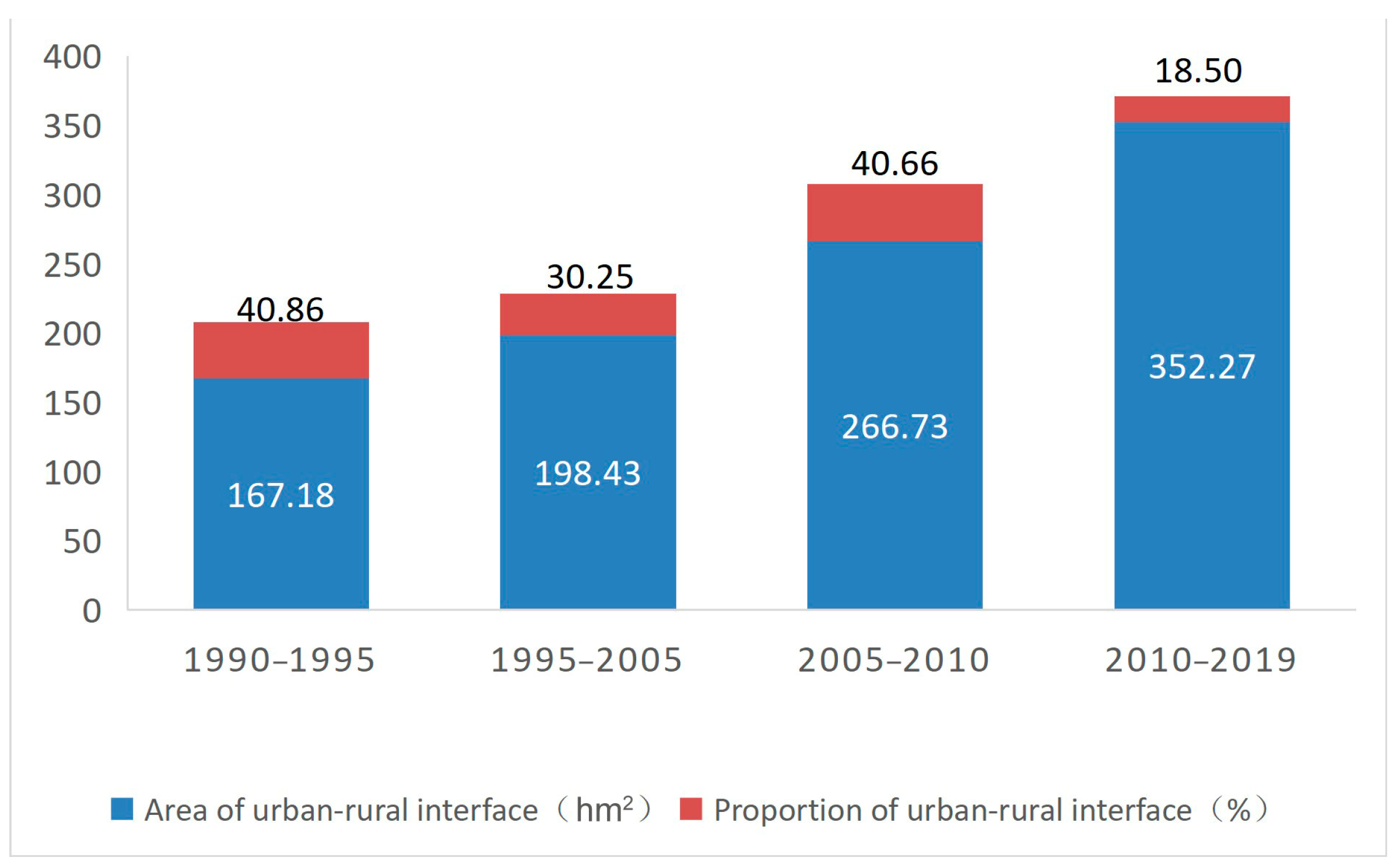
Focusing on the endogenous dynamics of land use transition and restructuring in villages and towns under the influence of macro-level policies, we proposed that the interplay between land resources and dominant land functions is facilitated by key local actors, leading to the transition and restructuring of local EPL spaces. In addition, this process may focus on a specific spatial interface area. Taking Zhulin in Central China as a case study and considering EPL spaces with both morphological and functional land use characteristics, we analyzed the processes, characteristics, and endogenous driving factors of spatial transition and restructuring over the past 30 years. We found that the distribution of EPL spaces in Zhulin shifted from the initial cross-distribution of ecological, production, and living spaces to a relatively concentrated layout. During 1990–2005, non-agricultural production space and living space continued to increase while agricultural production space and ecological space showed a fluctuating reciprocal transformation. Specifically, agricultural production space shrank and ecological space expanded at the beginning and reversed at the end. After 2005, the expansion trend of non-agricultural production space and living space was curbed. After the initial consolidation, reasonable growth followed; agricultural production space also continued to be consolidated while ecological space continued to grow. Compared with noninterface areas, the spatial interface areas did concentrate some more active shifts of EPL spaces. Among them, the reciprocal transformation of agricultural production space and ecological space was mainly concentrated in the terrain interface area, while the transfer involving non-agricultural production space and living space was mainly concentrated in the urban–rural interface area. In the process of the land use transformation of micro-level village and town cases, macro-level social and economic changes are the fundamental causes of land use transformation. The autonomous spatial governance capability of villagers’ self-organized institutions is key to regulating land use transformation. The spatial interface is a sensitive area of land use transformation in a natural state. On this basis, we propose an endogenous driving model of rural land use transformation that is proactive and responsive. Compared with existing macro-level-oriented research, for a single, more micro-level town, improving its autonomous rural spatial governance capacity will be more important. This requires establishing a top-down guidance mechanism and a bottom-up supervision mechanism to promote continuous innovation by rural self-organized institutions to adapt to the changing macroeconomic environment.
Compared with the traditional passive adaptation model, this active response model can significantly reduce the negative effects caused by land use pattern incompatibility in the process of changes in the external socioeconomic environment. Therefore, we need to pay attention to the characteristics of the spatial interface and land use transformation, which can provide us with the conditions to transform passive adaptation into active response. On this basis, the scientific formulation of local rural development strategies will be able to produce an integration effect, reduce negative impacts of land use transformation as much as possible, and promote local land use renovation to achieve greater gains at a lower cost. In the future, we need to pay attention to the comparative study of different types of case areas, and more attention should be paid to ways to improve the rural governance capacity of local actors at different levels.

Author Contributions

Conceptualization, D.H. and J.Q.; methodology, D.H. and J.Q.; formal analysis, D.H.; data curation, Q.Z. and J.X.; writing—original draft preparation, D.H.; writing—review and editing, J.Q. and Y.M.; visualization, Q.Z. and J.X.; supervision, J.Q.; funding acquisition, D.H. and J.Q. All authors have read and agreed to the published version of the manuscript.

Funding

This research was funded by the National Natural Science Foundation of China, Grant Numbers: 42201220, 42071220, 42271213 and the China Postdoctoral Science Foundation, Grant Number: 2021M701053.

Acknowledgments

We wish to thank the kind local villagers who were willing to be interviewed and the local government departments of Zhulin town and Gongyi City for providing relevant information.

Conflicts of Interest

The authors declare no conflict of interest.

References

  1. Newbold, T.; Hudson, L.N.; Arnell, A.P.; Contu, S.; De Palma, A.; Ferrier, S.; Hill, S.L.; Hoskins, A.J.; Lysenko, I.; Phillips, H.R.; et al. Has land use pushed terrestrial biodiversity beyond the planetary boundary? A global assessment. Science 2016, 353, 288–291. [Google Scholar] [CrossRef]
  2. Long, H. Land Use Transitions and Rural Restructuring in China; Springer Nature: Singapore, 2020; pp. 31–160. [Google Scholar] [CrossRef]
  3. Lambin, E.F.; Meyfroidt, P. Land use transitions: Socio-ecological feedback versus socio-economic change. Land Use Policy 2010, 27, 108–118. [Google Scholar] [CrossRef]
  4. Turner, B.N.; Lambin, E.F.; Reenberg, A. The emergence of land change science for global environmental change and sustainability. Proc. Natl. Acad. Sci. USA 2007, 104, 20666–20671. [Google Scholar] [CrossRef] [Green Version]
  5. Carella, E.; Orusa, T.; Viani, A.; Meloni, D.; Borgogno-Mondino, E.; Orusa, R. An Integrated, Tentative Remote-Sensing Approach Based on NDVI Entropy to Model Canine Distemper Virus in Wildlife and to Prompt Science-Based Management Policies. Animals 2022, 12, 1049. [Google Scholar] [CrossRef]
  6. Pepin, N.C.; Arnone, E.; Gobiet, A.; Haslinger, K.; Kotlarski, S.; Notarnicola, C.; Palazzi, E.; Seibert, P.; Serafin, S.; Schöner, W.; et al. Climate Changes and Their Elevational Patterns in the Mountains of the World. Rev. Geophys. 2022, 60, e2020RG000730. [Google Scholar] [CrossRef]
  7. Liu, Y.; Li, J.; Yang, Y. Strategic adjustment of land use policy under the economic transformation. Land Use Policy 2018, 74, 5–14. [Google Scholar] [CrossRef]
  8. Pătru-Stupariu, I.; Hossu, C.A.; Grădinaru, S.R.; Nita, A.; Stupariu, M.-S.; Huzui-Stoiculescu, A.; Gavrilidis, A.-A. A Review of Changes in Mountain Land Use and Ecosystem Services: From Theory to Practice. Land 2020, 9, 336. [Google Scholar] [CrossRef]
  9. Elshof, H.; Haartsen, T.; Van Wissen, L.J.G.; Mulder, C.H. The influence of village attractiveness on flows of movers in a declining rural region. J. Rural Stud. 2017, 56, 39–52. [Google Scholar] [CrossRef] [Green Version]
  10. Long, H. Land consolidation: An indispensable way of spatial restructuring in rural China. J. Geogr. Sci. 2014, 24, 211–225. [Google Scholar] [CrossRef]
  11. Ge, D.; Zhou, G.; Qiao, W.; Yang, M. Land use transition and rural spatial governance: Mechanism, framework and perspectives. J. Geogr. Sci. 2020, 30, 1325–1340. [Google Scholar] [CrossRef]
  12. Long, H.; Zhang, Y.; Tu, S. Rural vitalization in China: A perspective of land consolidation. J. Geogr. Sci. 2019, 29, 517–530. [Google Scholar] [CrossRef] [Green Version]
  13. Long, H.; Qu, Y. Land use transitions and land management—A mutual feedback perspective. Land Use Policy 2018, 74, 111–120. [Google Scholar] [CrossRef]
  14. Tu, S.; Long, H.; Zhang, Y.; Ge, D.; Qu, Y. Rural restructuring at village level under rapid urbanization in metropolitan suburbs of China and its implications for innovations in land use policy. Habitat Int. 2018, 77, 143–152. [Google Scholar] [CrossRef]
  15. Yang, R.; Liu, Y.; Long, H.; Zhang, Y. Research progress and prospect of rural transformation and reconstruction in China: Paradigms and main content. Prog. Geogr. 2015, 34, 1019–1030. (In Chinese) [Google Scholar]
  16. Li, Y.; Westlund, H.; Liu, Y. Why some rural areas decline while some others not— An overview of rural evolution in the world. J. Rural Stud. 2019, 68, 135–143. [Google Scholar] [CrossRef]
  17. Liu, Y.; Yan, B.; Wang, Y. Urban-rural development problems and transformation countermeasures in the new period in China. Econ. Geogr. 2016, 36, 1–8. (In Chinese) [Google Scholar] [CrossRef]
  18. Deng, Q.; Li, E.; Zhang, P. Livelihood sustainability and dynamic mechanisms of rural households out of poverty: An empirical analysis of Hua County, Henan Province, China. Habitat Int. 2020, 99, 102160. [Google Scholar] [CrossRef]
  19. Li, E.; Xu, Y.; Ren, S.; Lee, J. Spin-Offs, Innovation Spillover and the Formation of Agricultural Clusters: The Case of the Vegetable Cluster in Shouguang City, Shandong Province, China. Land 2022, 11, 279. [Google Scholar] [CrossRef]
  20. Long, H.; Li, Y.; Liu, Y.; Woods, M.; Zou, J. Accelerated restructuring in rural China fueled by ‘increasing vs. decreasing balance’ land-use policy for dealing with hollowed villages. Land Use Policy 2012, 29, 11–22. [Google Scholar] [CrossRef]
  21. Li, E.; Deng, Q.; Zhou, Y. Livelihood resilience and the generative mechanism of rural households out of poverty: An empirical analysis from Lankao County, Henan Province, China. J. Rural Stud. 2022, 93, 210–222. [Google Scholar] [CrossRef]
  22. Long, H.; Woods, M. Rural Restructuring under Globalization in Eastern Coastal China— What can we learn from Wales? J. Rural Community Dev. 2011, 6, 70–94. [Google Scholar]
  23. Ge, D.; Long, H.; Zhang, Y.; Ma, L.; Li, T. Farmland transition and its influences on grain production in China. Land Use Policy 2018, 70, 94–105. [Google Scholar] [CrossRef]
  24. You, H.; Hu, X.; Wu, Y. Farmland use intensity changes in response to rural transition in Zhejiang province, China. Land Use Policy 2018, 79, 350–361. [Google Scholar] [CrossRef]
  25. Long, H.; Heilig, G.K.; Li, X.; Zhang, M. Socio-economic development and land-use change—Analysis of rural housing land transition in the Transect of the Yangtse River, China. Land Use Policy 2007, 24, 141–153. [Google Scholar] [CrossRef]
  26. Xu, M.; Zhang, Z. Spatial differentiation characteristics and driving mechanism of rural-industrial Land transition: A case study of Beijing-Tianjin-Hebei region, China. Land Use Policy 2021, 102, 105239. [Google Scholar] [CrossRef]
  27. Chen, K.; Long, H.; Liao, L.; Tu, S.; Li, T. Land use transitions and urban-rural integrated development: Theoretical framework and China’s evidence. Land Use Policy 2020, 92, 104465. [Google Scholar] [CrossRef]
  28. Li, T.; Long, H.; Liu, Y.; Tu, S. Multi-scale analysis of rural housing land transition under China’s rapid urbanization: The case of Bohai Rim. Habitat Int. 2015, 48, 227–238. [Google Scholar] [CrossRef]
  29. Ge, D.; Wang, Z.; Tu, S.; Long, H.; Yan, H.; Sun, D.; Qiao, W. Coupling analysis of greenhouse-led farmland transition and rural transformation development in China’s traditional farming area: A case of Qingzhou City. Land Use Policy 2019, 86, 113–125. [Google Scholar] [CrossRef]
  30. Su, S.; Yang, C.; Hu, Y.; Luo, F.; Wang, Y. Progressive landscape fragmentation in relation to cash crop cultivation. Appl. Geogr. 2014, 53, 20–31. [Google Scholar] [CrossRef]
  31. Tian, Q.; Guo, L.; Zheng, L. Urbanization and rural livelihoods: A case study from Jiangxi Province, China. J. Rural Stud. 2016, 47, 577–587. [Google Scholar] [CrossRef]
  32. Lu, X.; Shi, Y.; Chen, C.; Yu, M. Monitoring cropland transition and its impact on ecosystem services value in developed regions of China: A case study of Jiangsu Province. Land Use Policy 2017, 69, 25–40. [Google Scholar] [CrossRef]
  33. Liang, X.; Jin, X.; Ren, J.; Gu, Z.; Zhou, Y. A research framework of land use transition in Suzhou City coupled with land use structure and landscape multifunctionality. Sci. Total Environ. 2020, 737, 139932. [Google Scholar] [CrossRef] [PubMed]
  34. Estacio, I.; Basu, M.; Sianipar, C.P.M.; Onitsuka, K.; Hoshino, S. Dynamics of land cover transitions and agricultural abandonment in a mountainous agricultural landscape: Case of Ifugao rice terraces, Philippines. Landscape Urban Plan. 2022, 222, 104394. [Google Scholar] [CrossRef]
  35. Qu, Y.; Jiang, G.; Li, Z.; Tian, Y.; Wei, S. Understanding rural land use transition and regional consolidation implications in China. Land Use Policy 2019, 82, 742–753. [Google Scholar] [CrossRef]
  36. Qu, Y.; Long, H. The economic and environmental effects of land use transitions under rapid urbanization and the implications for land use management. Habitat Int. 2018, 82, 113–121. [Google Scholar] [CrossRef]
  37. Zhou, Y.; Li, X.; Liu, Y. Land use change and driving factors in rural China during the period 1995-2015. Land Use Policy 2020, 99, 105048. [Google Scholar] [CrossRef]
  38. Long, H.; Liu, Y.; Hou, X.; Li, T.; Li, Y. Effects of land use transitions due to rapid urbanization on ecosystem services: Implications for urban planning in the new developing area of China. Habitat Int. 2014, 44, 536–544. [Google Scholar] [CrossRef]
  39. Tian, J.; Wang, B.; Zhang, C.; Li, W.; Wang, S. Mechanism of regional land use transition in underdeveloped areas of China: A case study of northeast China. Land Use Policy 2020, 94, 104538. [Google Scholar] [CrossRef]
  40. Liu, Y.; Long, H. Land use transitions and their dynamic mechanism: The case of the Huang-Huai-Hai Plain. J. Geogr. Sci. 2016, 26, 515–530. [Google Scholar] [CrossRef] [Green Version]
  41. Su, K.; Yang, Q.; Zhang, B.; Zhang, Z. The coupling mechanism between rural land use transition and small-scale peasant economy change in mountainous areas. Geogr. Res. 2019, 38, 399–413. (In Chinese) [Google Scholar]
  42. Long, H.; Qu, Y.; Tu, S.; Zhang, Y.; Jiang, Y. Development of land use transitions research in China. J. Geogr. Sci. 2020, 30, 1195–1214. [Google Scholar] [CrossRef]
  43. Shao, J.; Li, Y.; Wei, C.; Xie, D. The drivers of land use change at regional scale assessment and prospects. Adv. Earth Sci. 2007, 22, 798–809. (In Chinese) [Google Scholar]
  44. Song, X. Discussion on land use transition research framework. Acta Geogr. Sin. 2017, 72, 471–487. (In Chinese) [Google Scholar]
  45. Taylor, P.J. Is there a Europe of Cities? World Cities and the Limitations of Geographical Scale Analyses. In Scale and Geographic Inquiry Nature, Society, and Method; Sheppard, E., Mcmaster, R.B., Eds.; Blackwell Publishing: Oxford, UK, 2004; pp. 213–235. [Google Scholar]
  46. Holling, C.S. Cross-Scale Morphology, Geometry, and Dynamics of Ecosystems. Ecol. Monogr. 1992, 62, 447–502. [Google Scholar] [CrossRef]
  47. Zhang, Q.; Li, F. Correlation between land use spatial and functional transition: A case study of Shaanxi Province, China. Land Use Policy 2022, 119, 106194. [Google Scholar] [CrossRef]
  48. Long, H. Theorizing land use transitions: A human geography perspective. Habitat Int. 2022, 128, 102669. [Google Scholar] [CrossRef]
  49. Grainger, A. National Land Use Morphology: Patterns and Possibilities. Geography 1995, 80, 235–245. [Google Scholar]
  50. Huang, A.; Xu, Y.; Lu, L.; Liu, C.; Zhang, Y.; Hao, J.; Wang, H. Research progress of the identification and optimization of production-living-ecological spaces. Prog. Geogr. 2020, 39, 503–518. (In Chinese) [Google Scholar] [CrossRef]
  51. Yu, Z.; Xu, E.; Zhang, H.; Shang, E. Spatio-temporal coordination and conflict of production-living-ecology land functions in the Beijing-Tianjin-Hebei Region, China. Land 2020, 9, 170. [Google Scholar] [CrossRef]
  52. De, Z.; Xu, J.; Lin, Z. Conflict or coordination?—Assessing land use multi-functionalization using production-living-ecology analysis. Sci. Total Environ. 2017, 577, 136–147. [Google Scholar] [CrossRef]
  53. Cao, H.X. Modelling of a system boundary. Kybernetes 1995, 24, 44–49. [Google Scholar] [CrossRef]
  54. Qiao, J.; Lee, J.; Ye, X. Spatiotemporal Evolution of Specialized Villages and Rural Development: A Case Study of Henan Province, China. Ann. Assoc. Am. Geogr. 2016, 106, 1–19. [Google Scholar] [CrossRef]
  55. Ma, Y.; Qiao, J.; Han, D. Interpreting the Humanistic Space of Urban-rural interface Using Consumption Behaviors. J. Rural Stud. 2022, 93, 513–521. [Google Scholar] [CrossRef]
  56. Han, D.; Qiao, J.; Ma, Y.; Zhu, Q. The influence of spatial interfaces on rural economic restructuring in rapidly industrializing areas: A case study of Gongyi city in central China. Growth Chang. 2022, 53, 1210–1242. [Google Scholar] [CrossRef]
  57. Hu, S.; Tong, L.; Long, H. Land use transition potential and its assessment framework. Geogr. Res. 2019, 38, 1367–1377. (In Chinese) [Google Scholar]
  58. Yang, Y.; Bao, W.; Li, Y.; Wang, Y.; Chen, Z. Land use transition and its eco-environmental effects in the Beijing–Tianjin–Hebei urban agglomeration— A production–living–ecological perspective. Land 2020, 9, 285. [Google Scholar] [CrossRef]
  59. Yang, Y.; Bao, W.; Liu, Y. Coupling coordination analysis of rural production-living-ecological space in the Beijing-Tianjin-Hebei region. Ecol. Indic. 2020, 117, 106512. [Google Scholar] [CrossRef]
  60. Liu, J.; Liu, Y.; Li, Y. Classification evaluation and spatial-temporal analysis of “production-living-ecological” spaces in China. Acta Geogr. Sin. 2017, 72, 1290–1304. (In Chinese) [Google Scholar] [CrossRef]
  61. Whittaker, R.H. Vegetation of the Siskiyou Mountains, Oregon and California. Ecol. Monogr. 1960, 30, 279–338. [Google Scholar] [CrossRef]
  62. Johnston, C.A.; Pastor, J.; Pinay, G. Quantitative Methods for Studying Landscape Boundaries. In Landscape Boundaries; Hansen, J., di Castri, F., Eds.; Springer: New York, NY, USA, 1992; pp. 107–125. [Google Scholar]
  63. Han, D.; Qiao, J.; Zhu, Q. Rural-Spatial Restructuring Promoted by Land-Use Transitions: A Case Study of Zhulin Town in Central China. Land 2021, 10, 234. [Google Scholar] [CrossRef]
  64. Huang, Q.; Li, M.; Chen, Z.; Li, F. Land consolidation—An approach for sustainable development in rural China. Ambio 2011, 40, 93–95. [Google Scholar] [CrossRef] [Green Version]
  65. Tian, Y.; Liu, Y.; Liu, X.; Kong, X.; Liu, G. Restructuring rural settlements based on subjective well-being (SWB)—A case study in Hubei province, central China. Land Use Policy 2017, 63, 255–265. [Google Scholar] [CrossRef]
  66. Wen, T.; Kinchi, L.; Cheng, C.; He, H. Ecological Civilization, Indigenous Culture, and Rural Reconstruction in China. Mon. Rev. 2012, 63, 29–35. [Google Scholar] [CrossRef] [Green Version]
  67. Ren, G.; Zhu, X.; Heerink, N.; Feng, S.; van Ierland, E.C. Persistence of land reallocations in Chinese villages—The role of village democracy and households’ knowledge of policy. J. Rural Stud. 2022, 93, 336–344. [Google Scholar] [CrossRef]
  68. Ma, X.; Heerink, N.; Feng, S.; Shi, X. Farmland tenure in China: Comparing legal, actual and perceived security. Land Use Policy 2015, 42, 293–306. [Google Scholar] [CrossRef]
  69. Li, Y.; Westlund, H.; Zheng, X.; Liu, Y. Bottom-up initiatives and revival in the face of rural decline: Case studies from China and Sweden. J. Rural Stud. 2016, 47, 506–513. [Google Scholar] [CrossRef]
  70. Li, G.; Wang, Y. Autonomous rural spatial governance: A comprehensive analysis framework. City Plan. Rev. 2021, 45, 67–72. (In Chinese) [Google Scholar]
  71. Zhang, B.; Gao, J.; Gao, Y.; Cai, W.; Zhang, F. Land use transition of mountainous rural areas in China. Acta Geogr. Sin. 2018, 73, 503–517. (In Chinese) [Google Scholar]
Figure 1. Diagram of the theoretical framework.
Land 11 02289 g001
Figure 2. Geographical location and topographic characteristics of Zhulin in 2019. Reference system GCS Xian 1980.
Land 11 02289 g002
Figure 3. Principle of the moving split window technique.
Land 11 02289 g003
Figure 4. Spatial distribution of Zhulin’s EPL spaces, 1990–2019. Reference system GCS Xian 1980.
Land 11 02289 g004
Figure 5. Spatial distribution of Zhulin’s terrain interface. Reference system GCS Xian 1980.
Land 11 02289 g005
Figure 6. Spatial distribution of Zhulin’s urban–rural interface. Reference system GCS Xian 1980.
Land 11 02289 g006
Figure 7. Characteristics of changes in the number of terrain interfaces in Zhulin, 1990–2019. Note: The administrative area of Zhulin did not change during 2005–2010, so the area and proportion of terrain interfaces are the same as during 1995–2005.
Land 11 02289 g007
Figure 8. Characteristics of changes in the number of urban–rural interfaces in Zhulin, 1990–2019.
Land 11 02289 g008
Figure 9. Driving mode of EPL spatial land use transformation.
Land 11 02289 g009
Table 1. EPL spatial classification system.
Ecological–Production–Living Space ClassificationLevel 1 Land Use TypeLevel 2 Land Use Type
Ecological spaceGreen spacePublic Green Space
Protected Green Space
Water and other landWater
Forest land in agricultural and forestry land
Unused land
Pasture for grazing
Agricultural production spaceProduction facility landLand for agricultural production services
Water and other landAgricultural land, vegetable land, garden land, nursery
Non-agricultural production spaceProduction facility landClass 1 industrial land
Class 2 industrial land
Class 3 industrial land
Land for storage facilitiesLand for general storage
Land for storing hazardous materials
Land for public facilities Commercial and financial land
Market land
Living spaceLand for residential facilitiesClass 1 residential land
Class 2 residential land
Land for public facilitiesLand for administration
Land for educational institutions
Land for cultural, sports and technology
Land for healthcare
External transportation landLand for highways
Land for other transportation
Engineering facilities landLand for public engineering
Land for sanitation facilities
Land for disaster prevention facilities
Table 2. Spatial transfer of EPL spaces from 1990 to 2019.
Area (hm2)Initial Year
Final YearNon-Agricultural Production SpaceAgricultural Production SpaceLiving SpaceEcological SpaceTotal
Non-agricultural production space16.302.100.743.6122.76
20.05 *7.31 *3.21 *17.28 *47.84 *
41.35 **2.57 **0.82 **1.14 **45.87 **
58.07 ***33.66 ***15.29 ***17.13 ***124.14 ***
Agricultural production space0.24176.140.488.73185.60
0.91 *241.87 *5.60 *109.01 *357.38 *
1.52 **280.09 **11.44 **15.33 **308.38 **
2.81 ***548.56 ***13.36 ***108.80 ***673.52 ***
Living space0.762.2444.592.1249.70
2.80 *29.43 *57.47 *29.43 *119.12 *
0.71 **9.29 **100.38 **1.93 **112.31 **
5.19 ***32.37 ***158.62 ***7.74 ***203.92 ***
Ecological space0.0337.620.41113.04151.10
0.42 *18.43 *0.97 *111.86 *131.67 *
4.36 **65.29 **6.01 **113.78 **189.45 **
1.83 ***196.24 ***12.13 ***692.59 ***902.79 ***
Total17.33218.1146.22127.50409.16
24.17 *297.03 *67.24 *267.57 *656.01 *
47.94 **359.05 **118.65 **132.18 **656.01 **
67.90 ***810.83 ***199.39 ***826.26 ***1904.38 ***
Note: The area data without “*” represents spatial transfer of EPL spaces from 1990 to 1995, and the area data with “*”, “**” and “***” represent spatial transfer of EPL spaces from 1995 to 2005, 2005 to 2020, and 2010 to 2019 respectively.
Table 3. Types of spatial interfaces in Zhulin and the basis of classification.
Primary ClassificationSecondary ClassificationBasis of Classification
Natural interfaceTerrain interfaceAccording to elevation
Human interfaceUrban–rural interfaceProportion of urban construction land
Table 4. Spatial transfer of EPL spaces in the terrain interface area from 1990 to 1995.
Transfer of EPL Spaces, 1990–1995Amount of Transfer in the Terrain Interface (hm2)Total Amount of Transfer (hm2) Location Entropy of Land Use Transfer
Agricultural production spaceNon-agricultural production space0.002.100.00
Living space1.142.241.55
Ecological space18.1437.621.46
Non-agricultural production spaceAgricultural production space0.000.240.00
Living space0.000.760.00
Ecological space0.000.030.00
Living spaceNon-agricultural production space0.000.740.00
Agricultural production space0.060.480.37
Ecological space0.140.411.04
Ecological spaceNon-agricultural production space0.013.610.01
Agricultural production space6.158.732.13
Living space0.672.120.95
Table 5. Spatial transfer of EPL spaces in the terrain interface area from 1995 to 2005.
Transfer of EPL Spaces, 1995–2005Amount of Transfer in the Terrain Interface (hm2)Total Amount of Transfer (hm2)Location Entropy of Land Use Transfer
Agricultural production spaceNon-agricultural production space0.427.310.23
Living space1.9129.430.26
Ecological space6.0918.431.33
Non-agricultural production spaceAgricultural production space0.000.910.00
Living space0.002.800.00
Ecological space0.000.420.00
Living spaceNon-agricultural production space0.043.210.05
Agricultural production space1.095.600.78
Ecological space0.560.972.33
Ecological spaceNon-agricultural production space0.9417.280.22
Agricultural production space21.45109.010.79
Living space1.8229.430.25
Table 6. Spatial transfer of EPL spaces in the terrain interface area from 2005 to 2010.
Transfer of EPL Spaces, 2005–2010Amount of Transfer in the Terrain Interface (hm2)Total Amount of Transfer (hm2)Location Entropy of Land Use Transfer
Agricultural production spaceNon-agricultural production space0.002.570.00
Living space2.329.291.00
Ecological space33.5865.292.06
Non-agricultural production spaceAgricultural production space0.001.520.00
Living space0.000.710.00
Ecological space0.794.360.73
Living spaceNon-agricultural production space0.000.820.00
Agricultural production space3.2511.441.14
Ecological space1.456.010.97
Ecological spaceNon-agricultural production space0.001.140.00
Agricultural production space7.4915.331.96
Living space0.861.930.44
Table 7. Spatial transfer of EPL spaces in the terrain interface area from 2010 to 2019.
Transfer of EPL Spaces, 2010–2019Amount of Transfer in the Terrain Interface (hm2)Total Amount of Transfer (hm2)Location Entropy of Land Use Transfer
Agricultural production spaceNon-agricultural production space1.3633.660.12
Living space4.6732.370.44
Ecological space59.25196.240.93
Non-agricultural production spaceAgricultural production space0.012.810.01
Living space1.035.190.61
Ecological space0.001.830.00
Living spaceNon-agricultural production space0.9615.290.19
Agricultural production space1.1613.360.27
Ecological space1.7912.130.46
Ecological spaceNon-agricultural production space6.0317.131.08
Agricultural production space25.46108.800.72
Living space3.647.741.45
Table 8. Spatial transfer of EPL spaces in the urban–rural interface area from 1990 to 1995.
Transfer of EPL Spaces in 1990–1995Amount of Transfer in the Urban–Rural Interface (hm2)Total Amount of Transfer (hm2)Location Entropy of Land Use Transfer
Agricultural production spaceNon-agricultural production space2.082.102.42
Living space2.072.242.27
Ecological space6.0137.620.39
Non-agricultural production spaceAgricultural production space0.240.242.45
Living space0.760.762.45
Ecological space0.030.032.15
Living spaceNon-agricultural production space0.740.742.45
Agricultural production space0.410.482.11
Ecological space0.240.411.46
Ecological spaceNon-agricultural production space2.663.611.80
Agricultural production space0.278.730.08
Living space1.952.122.26
Table 9. Spatial transfer of EPL spaces in the urban–rural interface area from 1995 to 2005.
Transfer of EPL Spaces in 1995–2005Amount of Transfer in the Urban–Rural Interface (hm2)Total Amount of Transfer (hm2)Location Entropy of Land Use Transfer
Agricultural production spaceNon-agricultural production space5.317.312.40
Living space20.1929.432.27
Ecological space1.7818.430.32
Non-agricultural production spaceAgricultural production space0.000.910.00
Living space2.772.803.26
Ecological space0.220.421.77
Living spaceNon-agricultural production space2.523.212.59
Agricultural production space1.745.601.02
Ecological space0.230.970.80
Ecological spaceNon-agricultural production space10.1617.281.94
Agricultural production space12.38109.010.38
Living space19.9429.432.24
Table 10. Spatial transfer of EPL spaces in the urban–rural interface area from 2005 to 2010.
Transfer of EPL Spaces in 2005–2010Amount of Transfer in the Urban–Rural Interface (hm2)Total Amount of Transfer (hm2)Location Entropy of Land Use Transfer
Agricultural production spaceNon-agricultural production space1.822.571.74
Living space4.209.291.11
Ecological space1.3165.290.05
Non-agricultural production spaceAgricultural production space0.441.520.71
Living space0.620.712.15
Ecological space0.004.360.00
Living spaceNon-agricultural production space0.820.822.46
Agricultural production space4.4411.440.95
Ecological space3.646.011.49
Ecological spaceNon-agricultural production space0.001.140.00
Agricultural production space2.0815.330.33
Living space0.121.930.15
Table 11. Spatial transfer of EPL spaces in the urban–rural interface area from 2010 to 2019.
Transfer of EPL Spaces in 2010–2019Amount of Transfer in the Urban–Rural Interface (hm2)Total Amount of Transfer (hm2)Location Entropy of Land Use Transfer
Agricultural production spaceNon-agricultural production space11.3433.661.82
Living space10.9532.371.83
Ecological space42.61196.241.17
Non-agricultural production spaceAgricultural production space0.552.811.06
Living space2.375.192.47
Ecological space1.611.834.74
Living spaceNon-agricultural production space3.8715.291.37
Agricultural production space6.1613.362.49
Ecological space5.9312.132.64
Ecological spaceNon-agricultural production space7.5717.132.39
Agricultural production space4.77108.800.24
Living space1.317.740.91
Publisher’s Note: MDPI stays neutral with regard to jurisdictional claims in published maps and institutional affiliations.

