Review

Review of Research on Non-Conforming Urban Expansion: Measurement, Interpretation, and Governance

1
School of Management, Lanzhou University, Lanzhou 730000, China
2
Zhejiang Yuanzhuo Technology Co., Ltd., Hangzhou 310012, China
*
Author to whom correspondence should be addressed.
Land 2022, 11(12), 2110; https://doi.org/10.3390/land11122110
Submission received: 3 October 2022 / Revised: 9 November 2022 / Accepted: 21 November 2022 / Published: 23 November 2022
(This article belongs to the Special Issue Urban Land Development in the Process of Urbanization)

Abstract

:
Spatial plans are widely used as a basic tool for regulating urban expansion. However, land development beyond zones planned for urban development is prevalent worldwide, posing a serious challenge to the implementation of spatial plans and their effectiveness in regulating urban expansion. This paper presents a review of research progress relating to the measurement, interpretation, and governance of non-conforming urban expansion. Spatial conformance between actual land use and plans is the basic criterion for evaluating the effectiveness of plans in containing urban expansion. Accordingly, scholars have developed multiple indicators and methods for directly and indirectly measuring non-conforming urban expansion. Previous studies have elucidated external and internal factors influencing non-conforming urban expansion, revealing the external conditions of non-conforming urban land expansion and the factors driving decisions on site selection for non-conforming land development. To address the existing issue of non-conforming urban land and to prevent and control future non-conforming urban development, scholars have proposed multiple governance strategies. Drawing on existing research progress, we offer suggestions for future academic research in this field.

1. Introduction

Unregulated and excessive urban expansion has many negative effects, notably increased farmland erosion, ecological damage, and environmental pollution; excessive energy consumption and carbon emissions; rising costs of public facilities; and the exacerbation of social inequality [1,2,3,4,5,6,7]. Therefore, the governance of urban expansion has become an important issue for sustainable development [8,9], especially in the many developing countries that are experiencing rapid urban expansion [10,11,12]. Spatial plans are widely regarded as a basic tool for governing urban expansion [13,14]. They are used to restrict or block urban development, limiting it to specified ranges through the definition of growth boundaries, red lines demarcating protected areas, and land use zoning so as to achieve the purpose of controlling the scale of urban expansion, regulating the spatial layout, and protecting ecological and agricultural core functional areas [15,16,17,18]. Assessing spatial conformance between actual land use and plans has become a primary method for evaluating the effectiveness of plans in containing urban expansion [19,20,21,22,23,24]. Previous studies that applied this method found that urban land development outside of zones planned for urban development (ZUDs) was prevalent in many countries and regions within Europe [18,25,26,27,28], South America [29,30], North America [31,32,33], Asia [22,34,35,36,37,38], Africa [39,40], and Oceania [20,41,42]. In this paper, we refer to urban land located outside ZUDs as non-conforming urban land (NCUL). Case studies have shown that more than 35% of urban land development in some cities in mainland China has occurred outside ZUDs defined in urban or land use master plans [24,37,43,44]. In light of their studies of the governance structure associated with spatial plans and spatial conformance between land use and plans, some scholars have argued that spatial plans have not played a positive role in the control of urban expansion in many regions; rather, they have become an important driving force for urban expansion and suburban urbanization [29,45,46]. Evidently, then, NCUL expansion has become an important issue in planning implementation and in the governance of urban expansion.
NCUL expansion has attracted the attention of researchers working in the field of spatial plan implementation and evaluation and the governance of urban expansion. The first step in this research entails the identification and measurement of NCUL. The preliminary identification of NCUL status that is based on an overlay analysis of actual land use and plans requires a simple assessment of whether the urban land falls within ZUDs; the available information is sparse [24,47,48]. Therefore, scholars have gradually developed more diversified direct indicators as well as indirect methods for measuring NCUL that can more comprehensively reflect the spatial relationships between actual urban expansion and plans.
As a second step, scholars aim to explain the mechanism of NCUL development. Many studies have found that large-scale NCUL expansion occurs despite the legally binding force of plans and the presence of not fully developed land within ZUDs [35,43,49]. The reason for this phenomenon is puzzling. An understanding of the mechanism of NCUL expansion would not only help to solve this puzzle but would also illuminate the factors driving urban expansion and the role of plans in governing urban expansion, thus providing insights for controlling NCUL development.
Another critical issue is how to control NCUL expansion. The control of urban expansion, optimization of the land use layout, and protection of natural resources and the ecological environment are important planning goals. Large-scale land development activities that are inconsistent with planning goals are destructive and disorderly, significantly hampering their realization [31,36,50]. However, several studies have shown that plans may become inapplicable because of the bounded rationality of plan makers and implementers, uncertainty about the future, and other human factors [24,47]. Moreover, some studies have found that it is neither possible nor advisable for the development outcomes to be precisely aligned with plans [51,52,53]. Land development that is inconsistent with plans may be a reasonable and expedient choice made by decision-makers that does not necessarily violate planning goals, potentially even playing a positive role in their realization [24,48]. Especially in developing countries with dysfunctional planning systems, non-conforming land development may have important positive economic and social impacts [28]. Therefore, NCUL development cannot be addressed using a one-size-fits-all approach; differentiated and targeted measures are required according to the actual situation.
This paper presents a review of the literature, focusing on research progress in the area of measurement methods, interpretations of mechanisms, and governance strategies for NCUL expansion. Accordingly, we propose suggestions for future research that can provide guiding inputs for the theoretical research and practical governance of NCUL expansion.
We used the following methods to search for and select studies within the literature. We used Google Scholar and the search engine developed by Lanzhou University to search for the related literature. Very few studies were found using the term—“non-conforming urban growth/sprawl/expansion/land development” in the literature search. Therefore, we used a combination of two terms to search for the literature. One is picked from the following terms—“plan implementation”, “plan evaluation”, “land use plan/planning/regulation”, “urban plan/planning”, “comprehensive plan/planning”, “spatial plan/planning”, “urban growth boundary”, and “zoning”. The other is picked from the terms, including “urban expansion”, “urban land”, “urban development”, “urban growth”, “urban sprawl”, “land/housing/residential development”, and “built-up area”. The studies that directly focused on the measurement, interpretation, or governance of NCUL expansion were selected from the search result. We did not select studies on non-conformance between plans and outcomes unless they were specifically related to NCUL development. However, the number of studies that we selected was still limited. Therefore, we also selected studies from the references listed in the selected studies. In addition, we drew on our understanding of China’s status concerning rapid urbanization and the many initiatives aimed at governing urban expansion using spatial plans in China, as well as our knowledge of Chinese studies on NCUL expansion. Accordingly, we selected 12 papers published in Chinese. Moreover, a significant proportion of these Chinese studies have proposed new indexes and indicators for measuring NCUL expansion. Therefore, we believe that these Chinese studies can enlighten the research and practices in other countries and regions.

2. Methods of Measuring the Expansion of NCUL

2.1. Measurement Based on Spatial Conformance

Using hand-drawn grids, Alterman [54] first performed overlay analyses to evaluate the consistency between land use and plans. With advancing technology, GIS-based spatial overlay analysis of land use and plans has been widely used for measuring the effects of planning in the governance of urban expansion [17,35,36,43]. As shown in Table 1, scholars have developed a set of evaluation indexes for assessing spatial conformance. These diverse indexes provide measurements of the overall conformance between urban expansion and plans, the direction and degree of deviation between urban expansion and plans, the distribution and evolution characteristics of NCUL development, direct factors driving NCUL expansion, the degree of planning violation, as well as the plans’ effectiveness in governing urban sprawl.

2.2. Indirect Indicators of Non-Conforming Urban Expansion

2.2.1. Issuance of Land Development Permits

Permit management is a core element within the planning implementation used in many countries and regions [20]. Some studies have assessed the status of NCUL development by comparing the number of permits issued within and outside of ZUDs [18,20,34,41,59]. Because permits are approved and issued by local governments, a survey of the number of permits issued outside ZUDs can directly reflect their attitudes and responses to spatial plans. However, this measurement index is flawed in three ways. First, a project may require several permits. Second, the scale of land development in projects corresponding to different permits may vary considerably. Third, the method does not shed light on informal and unauthorized land development. The first two deficiencies imply that simply considering the number of permits does not accurately reflect the scale of land development outside ZUDs. Previous studies have found that the scale of informal development outside ZUDs is extensive and particularly prominent in developing countries [44,60,61]. Therefore, the third deficiency mentioned above may lead to a significant underestimation of the scale of land development outside ZUDs.

2.2.2. Distribution of the Population and Its Movements

There are interactions between population size, distribution, mobility, and the layout of urban land [62,63]. Some studies assess the consistency between actual urban expansion and plans by comparing the spatial conformance of population size, distribution, mobility, and the ZUD. For example, Gennaio [25] reflected on plans’ role in controlling urban expansion and promoting compact urban growth by the changes in population size and density in built-up areas and the spatial conformance between built-up area expansion and land use plans. Long [64] assessed the degree of NCUL expansion and the effectiveness of plans in containing urban growth using data from location check-ins, transit smart cards, and residential travel surveys, which record the distribution of people’s movements and activities inside and outside ZUDs. The advantage of this indicator of NCUL expansion is that it extends from physical space to cover demographic factors, which, to some extent, reflect the degree of interaction and disconnection between planning schemes, social needs, and land use. However, it has a number of deficiencies. First, data on small-sized populations are relatively difficult to obtain. Second, population density and the degree of mobility vary for different land use types, which makes it difficult to judge the scale of NCUL expansion using this indicator. Third, spatial plans at small scales often lack goals of population control or agglomeration. Moreover, some of the population is distributed outside ZUDs, and daily movements of people occur between urban and rural areas and between cities. Therefore, there is a lack of criteria for evaluating the effects of plans in governing urban expansion and the expansion of NCUL based on this indicator. Consequently, it is difficult to determine to what extent differences in the population distribution inside and outside ZUDs and population movements across urban growth boundaries reflect the degree of NCUL expansion.

2.2.3. The Value of Real Estate and the Tax Revenue That It Generates

The value of real estate and the tax revenue that it generates are closely related to the scale of land development. Some scholars assess NCUL expansion according to whether the total value and tax revenue from real estate and their increments are confined to ZUDs. Examples include Chapin [31] and Esnard [65], who used property-parcel polygons and property-appraisal tax rolls to analyze the development of housing in some areas located within ocean front hazard zones, where development was restricted in the plans. They reported significant increases in real estate values, the taxable base, and tax revenue in these areas, which, they argued, revealed the limits of local urban growth management policies. This indicator has the advantage of reflecting market forces driving urban development and its response to plans. However, it entails two deficiencies. First, it cannot directly reflect the scale of NCUL development, and second, it is susceptible to changes in real estate prices.

2.2.4. Econometric Models

Some studies use quantitative methods to analyze the effects of spatial plans in controlling urban expansion. For example, the difference-in-difference model, the logistic model, and the probit model were respectively used by Dempsey [32] and He [66], Tian [43] and Shen [17,67], and Cho [68,69] to test whether the possibility of developing land plots outside ZUDs was significantly lower compared with plot development within ZUDs. The test performed by Jun [70] using a housing supply model revealed that the dummy variable—whether land plots were inside the ZUD—did not significantly influence the location of new housing development projects in Portland, thus demonstrating the limited effect of the plans. The advantage of this measurement method is that it is generally effective in evaluating the inhibitory effect of plans on NCUL development, thereby reflecting the effectiveness of plans in controlling urban expansion and their binding effect on the selection of sites for land development projects.

2.3. Classification of NCUL

2.3.1. Types of NCUL Defined by Changes in Land Use Types

Loh [71] differentiated three categories of NCUL. The first is land that is planned but not yet developed as urban land, such as natural areas within ZUDs. The second is NCUL that has been developed before the plans, such as some types of urban industrial land that are to be developed commercially but have not been converted to commercial use. The third category is NCUL that has been urbanized during the planning period, for example, land that is planned as farmland but was developed into residential areas. The first two types of NCUL conceivably arise primarily because of delays in plans’ implementation. However, if the land use type cannot be changed in accordance with the plans, the rationality of the plans should be considered. The third type reflects real land use behavior that conflicts with the plans.
Shen [48] divided land use conformance into four grades according to the consistency between land use types in the planning base year and current year and the plans. The first grade, in which the land use type at present and in the base year is consistent with the plan, is regarded as weakly effective. The second, in which the land use type was consistent with the plan in the base year but is currently inconsistent, is regarded as strongly ineffective. The third, in which the land use type was inconsistent with the plan in the base year but is currently consistent, is regarded as strongly effective. The fourth, in which the land use type in the base year and during the current period are both inconsistent with the plan, is regarded as weakly ineffective.
This classification system facilitates the identification of NCUL formation and enables the differentiation of the degree of non-conformance between plans and land development.

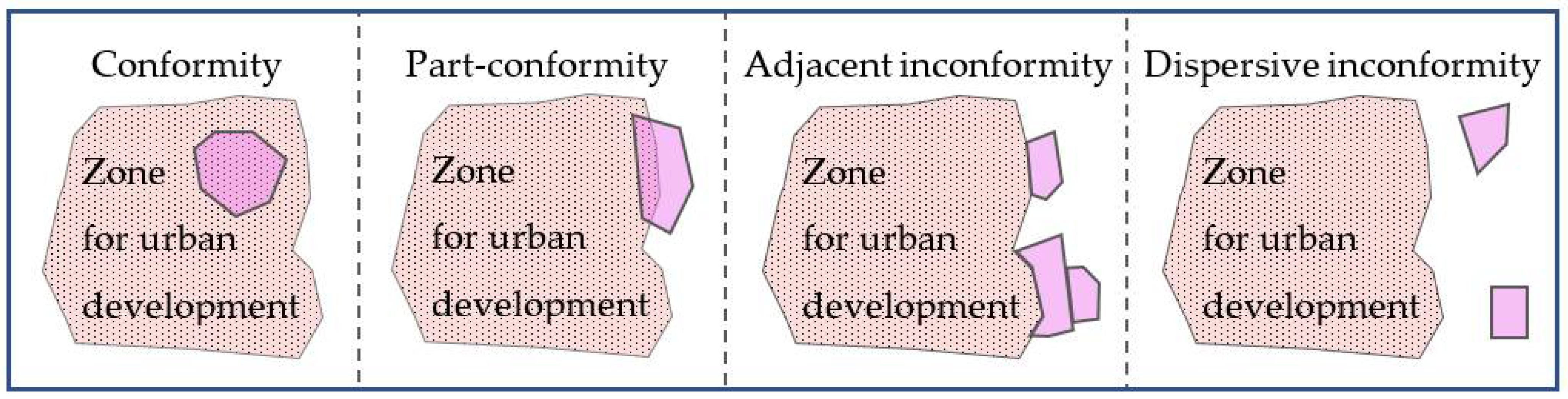
2.3.2. Types of NCUL Defined According to Their Spatial Distribution

Menzori [29], who studied the distribution characteristics of urban expansion, especially the development of NCUL, divided newly increased urban land into three types: newly generated, edge-expansion, and infill development.
Shen [17] identified four grades of land development compliance according to the spatial relationship between the urban land parcels and the ZUDs, respectively reflecting complete conformity, partial conformity, adjacent inconformity, and dispersive inconformity (Figure 1).
Classification according to spatial distribution can reveal the direct cause of NCUL development. Partial consistency or adjacent inconsistency may be caused by the saturation of land development in a partial range within a ZUD. More importantly, it can reveal the extent to which NCUL expansion violates the plan and undermines the planning objectives of achieving compact growth and controlling leapfrog expansion.

2.3.3. Types of NCUL Defined According to a Comprehensive Score

Considering the criteria derived from the terminologies and types of land use classification within planning schemes, Limb [42] assigned comprehensive scores based on an examination of overlapping layers (e.g., zones and plans) and component layers within land use regulations. Accordingly, three types of land parcels are defined. The first type is conforming areas in which land use is aligned with a score that reflects the planned use. The second type is under-developed areas in which the scale of land use is below the scale intended in the regulations. The third type is exceeding areas in which land use is of a type or scale that conflicts with or exceeds the level prescribed in the regulations.

2.3.4. Types of NCUL Defined According to the Legality of Their Development

In some countries and regions, ratified spatial plans are legally mandated, defining the legal framework of land use [28]. Accordingly, all NCUL development is illegal. However, in other countries and regions, spatial plans do not have statutory force, and, more importantly, land development outside ZUDs is not totally forbidden [69,72]. Accordingly, not all NCUL areas are illegal. For example, farmland located outside of ZUDs can be converted in Israel if approval is obtained from the Committee for the Protection of Agricultural Land [73]. Moreover, in many US counties, low-density housing development outside urban growth boundaries is permitted [32,74,75]. A significant proportion of NCUL development is approved or even conducted by governments [36]. Therefore, many studies have used the locations where permits are issued to measure non-conforming urban expansion, as mentioned in Section 2.2.1. The NCUL that has been authorized and permitted by governments is perceived as formal land development, and others that are not authorized are perceived as informal land development [44].
Differentiating the formality of UCUL development reveals local governments’ responses to spatial plans and their roles in NCUL development.
Table 2 summarizes the classification of NCUL by the above-mentioned studies.

3. Interpretations of NCUL Expansion

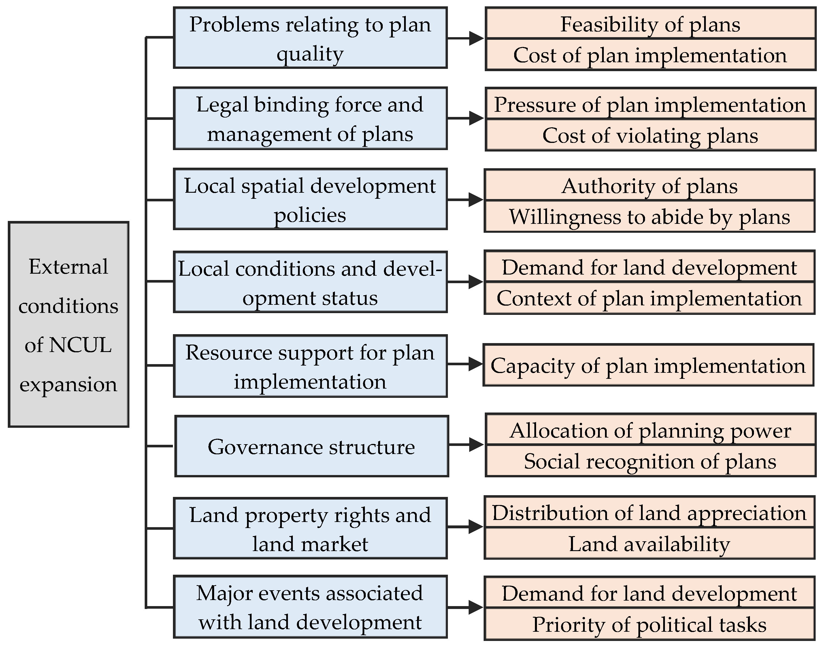
3.1. External Factors

As shown in Figure 2, some studies have analyzed the reasons for NCUL expansion from the perspective of the external conditions of planning implementation and NCUL development.

3.1.1. Problems of Planning Quality

The problems relating to plan quality result in the non-adaptiveness of plans to the actual needs of urban development and management. Consequently, economic costs increase and social welfare is reduced with the plan’s implementation, leading to a failure to actualize the urban land development according to the plans. Previous studies have found that quality-focused problems such as the fragmentation, insufficient size, and unreasonable layout of the ZUD [17,24,48,57], conflicts between different types of plans [43,58], the ambiguous location of urban growth boundaries and unclear regulations [34,37,59], the bypassing and violation of the prevailing development mode in the plan [71], and unclear boundaries between ecological land and reserved urban development land [76] are common causes of UCUL expansion. The above evitable problems of quality are artificially caused during the formulation of plans because the information is intractable and incomplete, e.g., uncertainty about the future and the formulation of spatial plans is a bounded-rational process, resulting in a limited effect on regulating the location of unpredictable land development projects [77,78]. The problems of plans associated with bounded rationality are difficult to avoid and eliminate [67]. For example, for some development projects, a safe distance needs to be maintained between the projects and areas where human activities are concentrated. Consequently, the land provided for such projects is often located outside ZUDs [24]. Han [57] found that Beijing achieved the planned population increment, which was expected to be achieved over the entire planning period of nearly two decades, in just three years. Such rapid population growth was difficult to predict, resulting in a large number of areas of NCUL beyond the urban growth boundary defined according to the planned population.

3.1.2. The Binding Force of Plans and the Intensity of Supervision and Punitive Measures Relating to NCUL Development

The legally binding force of plans and the method and intensity of supervision and management for implementing the plans determine the amount of pressure relating to plan implementation and the cost of violating plans, which, in turn, affect NCUL development. NCUL expansion can be limited by giving plans a clear and legally binding force, formulating specific implementation rules and management measures and fine-tuning complementary regulations and punitive measures [27,79]. Clarifying the responsibility and financing mechanisms for planning implementation, strictly supervising the revision and implementation of plans, and introducing drastic punitive measures for violating plans can lead to a significant reduction in the issuance of permits that are inconsistent with the plans [80]. A case study in the Netherlands showed that restrictive zoning was effective in containing urban growth, largely because of its rigidity and clarity [81]. Another case study in Saudi Arabia showed that the strong administrative and legal foundation of urban growth boundaries compensated for their technical weakness and significantly prevented non-conforming land use [82]. Conversely, the lack of dynamic monitoring, effective supervision, and necessary punitive measures during plan implementation provides external incentives for NCUL development [36,44,57]. In addition, land development outside ZUDs that is not explicitly prohibited leads to fragmented or large-scale NCUL expansion [22,34]. Wang [37] argued that the legal effect of statutory urban growth boundaries is higher than that of urban growth boundaries as a component of spatial planning. Thus, the former boundary type has a more significant inhibitory effect on NCUL development. Shen [17] found that most NCULs are distributed in zones with less stringent restrictions on land development. Moreover, most of the land converted into NCUL is not targeted for protection within the plans.

3.1.3. Local Spatial Development Policies

Conflicts between local spatial development policies and plans affect the authority of the plans and interfere with their implementation, leading local governments to prioritize local policy implementation rather than plan implementation to realize local interests. Consequently, spatial plans can only play a limited role in containing urban growth, resulting in uncoordinated and incompatible spatial developments [40]. Case studies in China have shown that policies of industrial suburbanization encourage a large number of industrial land development activities that are inconsistent with the plans for suburbs [49,83]. Large-scale NCUL development results when the scope of development zones and industrial parks set by local governments exceeds the scope of ZUDs [36]. Development zones established by higher-level governments (e.g., provincial and national development zones) are regarded by local governments as “shields” to evade accountability relating to NCUL development [44]. The continuous adjustment of local spatial development policies aggravates their inconsistency with the plans and leads to intensified NCUL expansion [84]. Hence, spatial plans become increasingly ineffective in containing urban expansion close to the end of plan implementation [66]. The empirical studies by Shen [67] show that local spatial development policies can regulate the binding force of land use zoning on urban development. Specifically, if a zone in which urban development is restricted overlaps with a local economic development zone, the restrictive effect of the plans on urban development will be significantly reduced. Conversely, if the land use regulation policy in areas where urban development is restricted is combined with other policies (e.g., cultivated land and ecological protection policies and disaster prevention and reduction policies in disaster-sensitive areas), land development activities in the corresponding areas will be significantly reduced [85]. Moreover, if land use polices and restrictions make it difficult to develop land reserved for urban development inside the ZUD, the ZUD will fail to accommodate urban growth despite being large enough to do so [86].

3.1.4. Regional Development Status

Regional background factors, such as culture, society, and economy, affect the implementation of plans. Economic vitality, industrial structure, population dynamics, and land use conditions significantly affect the speed, scale, structure, and layout of land development. Regions with large economic aggregates and populations that are rapidly growing will face more problems and uncertainties in land use, making it more difficult to control urban expansion using plans [18,48]. The findings of an empirical study by Cho [33] indicated that inflated land prices within ZUDs stimulated the development of land of lower value outside the ZUD during a real estate boom. In addition, zoned agriculture parcels are more likely to be converted to housing developments during a recession period because local governments want to increase property tax revenues by re-zoning undevelopable land as developable land. Qian [76] has suggested that because central enterprises and wholly foreign-owned enterprises or joint ventures contribute more than 90.0% of the industrial output value of Nanjing, China, it is more difficult for local governments to implement plans, and they often passively accept sites selected for land development projects that are inconsistent with plans. Moreover, rapid population growth and the preference for suburban housing have stimulated the construction of new districts beyond ZUDs [64] and even induced informal housing development [46]. In regions characterized by slow-paced development, the demand for land is limited, and expansion of NCUL is relatively rare [32]. However, the case study by Gennaio [25] found that NCUL significantly expands at a low density under conditions of population decline.

3.1.5. Resource Support for Plan Implementation

The capacity to shape and influence the planning process, financial resources, power resources, and attitudes and skills within local governments are important factors affecting the implementation of plans and their ability to limit NCUL development [18]. The numbers and abilities of planning department personnel and their attitudes toward plans significantly affect their consideration and issuance of development permits for NCUL [20]. Local governments’ lack of personnel and resources to implement plans, monitor land development, and carry out law enforcement are important factors accounting for NCUL expansion [87]. A case study in China has found that because the density of rural residential areas in the suburbs of cities is high, along with the cost of land expropriation, and financial resources are limited, local governments choose to expropriate a large amount of land outside ZUDs to promote the construction of large-scale industrial parks with low land expropriation costs [44]. A case study in the USA has shown that because of the lack of financial resources, planning measures such as the transfer and resettlement of populations and the reduction of construction land cannot be carried out in ecological and natural disaster-sensitive areas where land development is restricted by plans [31]. Consequently, large-scale residential districts remain and even expand in these areas.

3.1.6. The Governance Structure for the Planning Process

A governance regime is an important factor influencing the preparation and implementation of spatial plans [88]. The failure to give local governments autonomy to integrate considerations of local interest within top-down plans leads to a lack of incentives to implement the plans [85]. As a result, many mandatory restrictions on land development in high-level plans have not been effectively implemented at local levels [31]. The lack of participation of key actors, such as developers and property owners, in plan preparation and implementation reduces the social recognition and acceptance of plans and ultimately reduces the influence of the plans on land development [22]. However, Berke [41] argued that a rigid interpretation of planning policies, the strict implementation of regulations, and a lack of inter-subject consultations for approving and issuing development permits can reduce NCUL development. The excessive participation of property owners and developers in plan preparation and implementation may lead to the influence of personal economic agendas in the implementation of urban development boundaries [29]. Moreover, fragmented management, differences in development strategies at different levels of government, conflicts between departments, and the independent operations of various management committees will negatively affect the regulating effect of plans on urban expansion [49,76].

3.1.7. Land Property Rights and the Market System

To a certain extent, land property rights and market systems determine the role and interactions of relevant subjects in land development, the availability and cost of the land needed for project development, and the distribution of land value-added income, thus affecting the feasibility, organizational method, and incentive mechanism of NCUL development. In China, the decentralization of administrative, finance, and land management authorities has resulted in local governments becoming the key decision-makers in urban land development [76]. As the implementers and managers of the plans and the land expropriators and suppliers, investment seekers, and beneficiaries of land development, local governments can meet their own demands and those of market investors’ for NCUL development through strategic planning, whereby plans are modified to make land development compliant [43,76]. Some studies have found that the unavailability of land in the formal market and the lack of land development rights have led to the informal development of NCUL by disadvantaged developers and landowners [44,46].

3.1.8. Major Events Related to Urban Construction

The occurrence of major urban events has a significant impact on the structure and scale of urban land use, with major events often accorded high political priority; to some extent, this creates an opportunity for local governments to breach plans and carry out large-scale urban construction. For example, in Portugal, the World Exhibition of 1998 motivated large-scale exceptional urban development in Lisbon [89]. In China, many projects entailing major events, such as the Nanjing National Games, the Beijing Olympic Games, the Shanghai World Expo, and the Guangzhou Asian Games, were simultaneously developed and submitted or developed first and submitted for approval later to enable the construction to be completed without delay, resulting in a large number of land development types and scales and layouts inconsistent with the plans [76,79]. In Laos, to build the Lao International Convention Centre for hosting the Ninth Asia–Europe Meeting through urban renewal, the Vientiane authorities chose to develop new residential communities within the planned agricultural zones in peri-urban areas, where land is cheap, to resettle the original community residents [36].

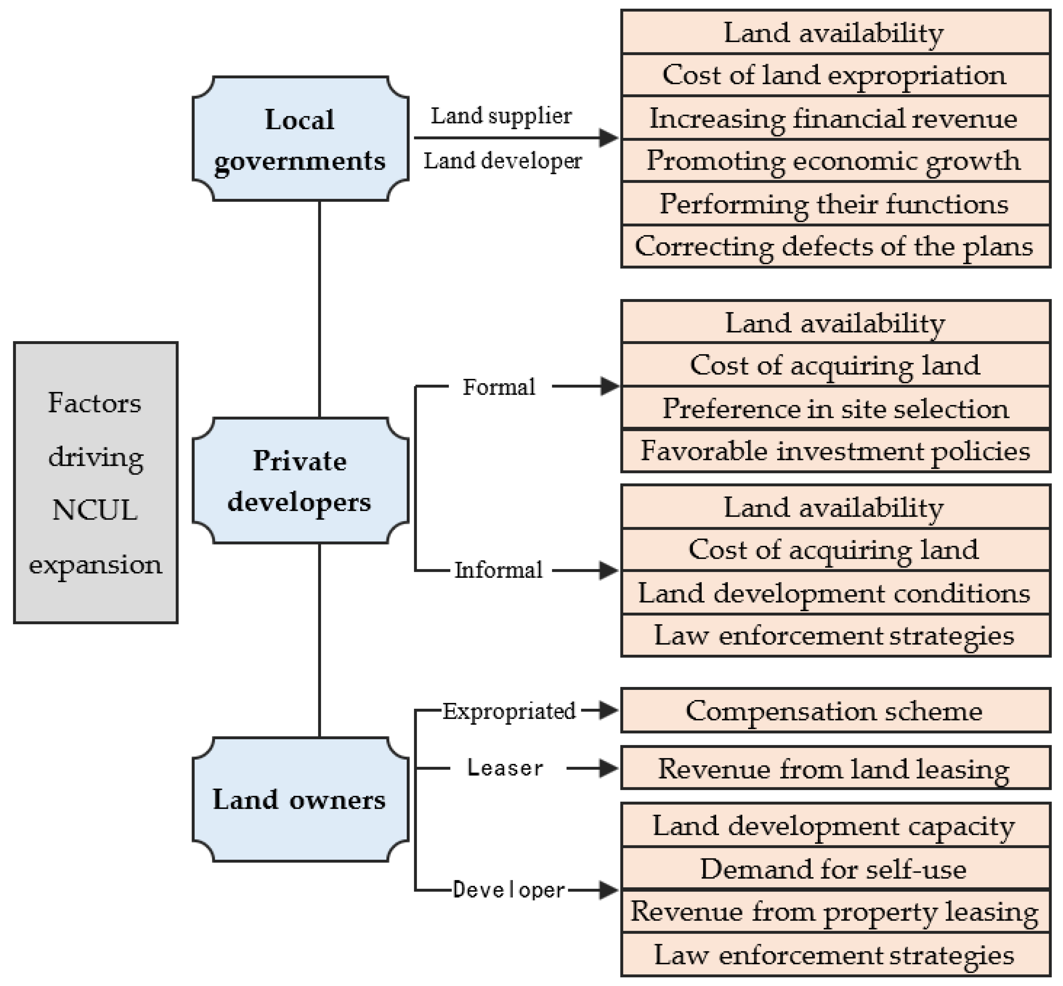
3.2. Internal Factors

External factors provide external conditions for NCUL development, but they cannot fully explain why NCUL development occurs. Some scholars have explored the decision-making behaviors of key actors related to land development (local governments, developers, and land rights owners) to reveal the reasons for NCUL expansion, especially the driving factors, as shown in Figure 3.

3.2.1. Local Governments

Local governments play an essential role in NCUL development and can determine whether investors are able to carry out land development outside the ZUD [73,90]. As a rational agent driven by interests, local governments tend to relax plan regulations and accept NCUL development [37,85]. They prefer large projects and actively work to satisfy large investors’ selection of sites for development by relaxing restrictions on urban growth boundaries [27,39]. Especially after changes in local leadership and the consequent changes in development strategy, NCUL development may increase significantly [76]. To promote economic growth and increase financial revenue, local governments in China actively promote the development of new towns and zones, during which the costs of the supply of large-scale public facilities and the expropriation of land, in turn, increase their dependence on land as a core tool for realizing local interests [46].
As the provider of land and public services, local governments will consider the availability and cost of land and the costs, social benefits, and economic returns (improving the development conditions and market value of the adjacent land) of public services and infrastructure supply. Thus, they tend to acquire land and build public facilities in suburbs that are more likely to be located outside ZUDs [44,83]. For example, in Laos, because of the limited amount and high value of land in the central urban area, the local government of Vientiane occupied the outer suburban farmland and woodland outside ZUDs to settle the people displaced by urban renewal and to attract investment [36].
As the designers and implementers of plans, agents of higher-level government, and maintainers of public order, local governments strategically accept or carry out NCUL development to balance local interests and the political risk of violating plans. Driven by financial incentives, they tend to take advantage of the weaknesses of planning systems to create opportunities for NCUL development [81]. To balance local interests, their governmental responsibilities, and the oversight of higher-level governments, local governments selectively enact law enforcement measures against the informal development of NCUL [44,91]. For example, Chinese case studies have found that in spite of the fact that local governments deploy land use plans to promote rather than constrain urban expansion by setting aside excessive land for development, they still frequently conduct and accept NCUL development [92]. They do so by supplying plots for development that are mostly located in land use zones where strict restrictions on land development are lacking. They also occupy land types that are not strictly protected by plans so as to avoid the risk of being held accountable by higher-level governments for land use behaviors that are in violation of the plans [67]. In addition, when plans fail to promote the realization of planning goals such as cultivated land and ecological protection, instead of hampering reasonable urban construction, local governments may break through the restrictions of plans to carry out NCUL development [48].
Governing philosophies also affect the decision-making of local governments regarding NCUL development [29]. Economic development, ecological and environmental protection, and urban sprawl governance have different value weights within different political parties. Therefore, governments formed by different political parties have different attitudes toward NCUL development [25].

3.2.2. Private Developers

The spatial conformance between urban land for profit-oriented projects development and plans is at a significantly lower level than that between urban land for public projects development and plans, reflecting the role of market forces in NCUL expansion [43]. Several empirical studies have shown that the variables used to reflect developers’ preferences relating to site selection are statistically significant factors influencing the probability of land development outside the ZUD [68,69]. This is not the case for the dummy variable—whether or not the land parcel is located inside the ZUD. Developers engaged in land development have profit motives [93]. As long as land property rights and development permits can be obtained, developers mainly consider the degree of satisfaction regarding conditions for developing the land parcel in relation to their project site preferences; they do not care whether the selected land parcel is located within ZUDs. In China, developers who find it very difficult to acquire state-owned land legally through formal channels will consider the land availability, price, location, and local government’s disposal strategy for informal land development when deciding whether to rent the collective land for informal development [44].
Chapin [31] and Brody [59] found that low land prices, improved transportation, proximity to coastal scenery, an increasing population, and housing demand drive developers to build residential areas in disaster-sensitive areas and wetland reserves, where land development is strictly restricted by plans. Zhang [83] has suggested that higher land availability, perfect infrastructure conditions, the agglomeration effect, and the government’s incentivization policies attract manufacturing investors to carry out project development in the outer suburbs beyond the ZUD. Cho [69] found that urban growth boundaries stimulate an increase in land prices inside ZUDs, which encourages developers to locate development projects along the rural–urban margins outside of these boundaries. Bigelow [72] found that the prices of exurban land outside the boundaries are rising because the amenities of these land attract residents and, hence, housing developers. Conversely, developers usually lack the willingness to invest in areas with marginal locations, poor infrastructure conditions, and weak development foundations within ZUDs [43,44]. In Saudi Arabia, vacant land outside ZUDs fails to attract developers because they need to provide the entire infrastructure themselves [82]. In addition, developers with different attitudes toward risks respond differently to plans; those who prefer to take risks are more likely to adopt land development strategies that violate plans [37,94].

3.2.3. Owners of Land Property Rights

Some studies have found that rapid rises in housing demand and price, driven by economic and population growth and the relaxation of government supervision, have stimulated owners of land property rights to carry out real estate development in violation of laws and plans to obtain considerable economic profits [36,43,87]. Driven by economic interests, owners of land property rights and grassroots governments lead or cooperate with developers to illegally develop large-scale, commercial, residential areas in fringe areas of big Chinese cities [46,95]. A case study of Laos has also found that urban migrants and residents of original communities experiencing urban renewal choose to buy land in rural areas on the edge of the city to build houses for themselves because they cannot afford the high housing prices in urban areas [36].
Shen [44] found that collective landowners in China play three kinds of roles in NCUL development. The first relates to the object of land expropriation, with their willingness depending mainly on the compensation scheme for land expropriation. The second relates to developers. Whether they carry out development depends on development costs and capabilities, requirements for self-use, expected economic benefits, and the government’s enforcement strategies against informal development. The final role is that of land leasers, wherein the willingness to lease land to developers depends largely on rent levels.

4. Governance of NCUL Expansion

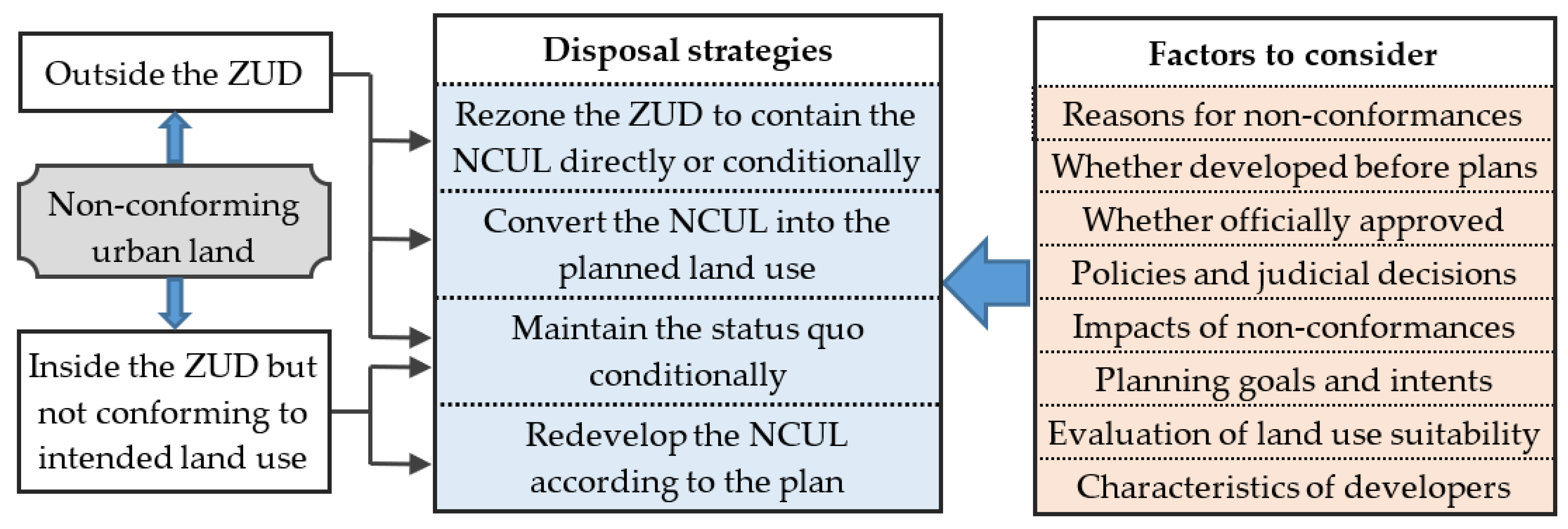
4.1. Disposal of Existing NCUL

As shown in Figure 4, previous studies have identified the following main strategies for the disposal of existing NCUL [71,91,96,97]. The first entails adjusting plans to enable the compliance of the NCUL with them. The second entails transforming the NCUL (remaining urban land use after the transformation) and then adjusting plans to enable the compliance of the NCUL with the plans after ensuring that land use meets specific conditions. The third entails the redevelopment of NCUL located within ZUDs to ensure that it conforms to the plans. The fourth is to maintain the status quo of NCUL according to certain conditions (e.g., not expanding the scale, controlling negative externalities, and not exceeding the prescribed period) without enforcing compliance with the plans. The fifth is to convert urban construction land into other land types according to the plans.
When choosing a disposal strategy, the following factors should be taken into consideration. The first relates to the reasons for NCUL development and the associated decision-making process [71,97]. The second relates to whether the NCUL is developed during the plan implementation period [48]. The third relates to whether the development of the NCUL is officially approved and authorized [44]. The fourth concerns relevant laws, regulations, policies, and judicial decisions [71,97]. The fifth factor focuses on the comprehensive benefits of NCUL development and its impact on meeting the planning objectives of compact urban development, sprawl control, solving urban problems, maintaining cultivated land, and protecting the ecological environment [24,79]. The sixth factor relates to the assessment of land use as being appropriate [96]. The seventh and final factor relates to the characteristics of land developers [91].
The case study by Shen [44], for example, found that several hectares of farmland outside the ZUD had been converted for industrial development. These parcels of farmland were surrounded by built-up areas, and most of them had been abandoned before conversion because the farmers had already become urban migrant workers. The circumjacent urban traffic and industries had a negative impact on the quality of the agricultural products. Moreover, these parcels of farmland were not targeted for protection by the plan. Their conversion does not harm the planning objectives of farmland protection; instead, it is conducive to promoting contiguous and compact urban expansion. Therefore, the authors suggested adjusting the plan to enable compliance with the non-conforming farmland conversion.
Urban land that existed prior to the issue of plans may have been converted into NCUL because it was not included in ZUDs or because the type of planned construction land was not consistent with the current situation. According to Loh [71] and Shen [48], permission to retain such land should be accepted according to the premise of not harming public interests and sustainable development. If changing land use according to the plans by relying on market forces proves difficult, the rationality of the plans should be reconsidered.
Some researchers have contended that disposal strategies can be selected on the basis of the assessment of land use suitability; those NCULs that are suitable for urban development and do not have significant negative impacts on farmland and ecological land protection can be included in the scope of the ZUD directly or after transformation [96]. For NCULs located in ecological or natural disaster-sensitive areas that are not suitable for development, the land use type should be changed according to the plans. If it is difficult to change the land use type because of public financial constraints, the status quo should be conditionally preserved [31].
Shen [44], Qian [76], and Luo [97] found that, in China, formally developed NCUL is mostly done to conform to plans via plan adjustment, whereas most of the informally developed land is conditionally maintained or demolished according to the governments’ requirements.

4.2. Reducing Future NCUL Development

4.2.1. Improving the Plans

The ZUD should be large enough to meet the reasonable needs of urban expansion [25]. The connectedness of the ZUD, according to the premise of protecting the ecological environment, should be enhanced, and spatial plans and local spatial development strategies should be coordinated [17]. Priority should be given to areas with good developmental conditions to be included in the ZUD, and a differentiated supply of infrastructure and public service facilities should be planned within and outside the ZUD [50,67]. The focus should be on controlling land development in urban fringe areas, establishing clear urban growth boundaries, encouraging high-density land development, and controlling leapfrog development [80]. “Top-down” control requirements and “bottom-up” construction needs should be fully considered in the planning scheme through the technological innovation and procedural optimization of planning to enhance the inclusiveness and adaptability of the plans [37].

4.2.2. Improving the Governance Structure for Planning Formulation and Implementation

The functions of planning formulation and implementation, which are scattered across different departments, should be integrated; a unified management approach should be adopted, and supervision and a restriction mechanism for planning management should be established [58,84]. A network of government agents at different levels, land property owners, market developers, and other stakeholders should be created, and their contacts, communication, and collaboration should be strengthened in processes of planning formulation and implementation to form a participatory governance structure and coordinate the goals of all parties as well as to resolve conflicts arising among them. This participatory governance structure can help to improve the scientificity and execution of plans while strengthening members’ cognition, understanding, recognition, and consciousness of the plans and realizing the social supervision of planning implementation, which would lead to a reduction in NCUL development [59,76,85]. However, some studies have emphasized that the participation of the private sector should be limited, or else economic interests relating to land development could sabotage the implementation of plans, resulting in unsuccessful efforts to control urban expansion [18]. Flexible adoption of a participatory or non-participatory governance structure that responds to the specific situations relating to NCUL development is required [41,94].

4.2.3. Optimizing the Rigidity or Elasticity of Plans

Local governments are strongly motivated to choose local interests over plan implementation, which calls for rigidity in spatial plans [85,92]. It is necessary to enact spatial planning laws and to formulate specific planning implementation rules, management methods, and complementary normative provisions to ensure that plans can constrain the selection of sites for land development [79]. Planning revisions driven by the inconsistency between land use and plans should be strictly controlled, and plans should be carefully adjusted and the frequency reduced [84]. Dynamic monitoring of plan implementation and urban expansion should be strengthened to deal with NCUL development in a timely and effective manner, and appropriate punitive measures should be taken against those who commit violations [50]. Moreover, the boundaries of urban development and red lines for protecting core ecological and agricultural functional areas should be defined to ensure that the land in protected areas is not occupied for urban development [17,35]. In terms of elasticity, differentiated and targeted management should be implemented. That is to say, the binding and controlling force related to planning for public purposes, the maintenance of open spaces, and the protection of ecological environments should be strengthened. In contrast, flexibility should be enhanced for market-oriented land use to reduce planning restrictions [43,44]. As suggested by Pu [98], a rigid boundary of urban growth outside the urban growth boundary should be defined. Accordingly, projects conforming to specific regulations can be implemented outside the urban growth boundary, but they should not be allowed to extend beyond the rigid boundary. Moreover, changes that are based on prediction and authority should be made in the planning system, and indicators such as land use efficiency and the effectiveness of ecology and farmland protection should be considered an important basis for plan implementation and land use management [58].

4.2.4. Improving Supportive Measures for Plan Implementation

The scope of ZUDs should be clarified, and onsite signs should be placed at the boundaries [34]. Guidance should be provided on the selection of sites for urban development, in line with the plans through the implementation of differentiated infrastructure and tax and price policies [99]. For example, in Saudi Arabia, the infrastructure inside ZUDs is provided by the government, whereas that located outside ZUDs is to be provided by the developers [82]. In Oregon in the United States, the establishment or extension of municipal services outside urban growth boundaries is forbidden [89]. Policies relating to the attraction of investments, land expropriation and supply, and spatial development should be coordinated with the spatial plans and their implementation [100]. In addition, local governments should compensate for negative impacts caused by growth management policies and plans [101]. For urban growth boundaries spanning administrative regions, coordinated policies on land supply, the distribution of benefits, and compensation should be established to encourage regions that make more effort to protect farmland and ecological environments and to adhere to the plans [43]. Experience from the Netherlands shows that policy instruments, such as land acquisition and financial or fiscal incentives for landowners, help to reduce land development in zones set aside for open-space preservation [81].

4.2.5. Improving Dynamic Plan Management

To cope with uncertainties and various challenges, dynamic plan management should be strengthened, and norms for plan adjustment, supervision, and monitoring should be formulated [79]. The dynamic monitoring and evaluation of plan implementation should be improved, and overall monitoring and special monitoring (in key areas, including the urban fringes) should be conducted using GIS and big data to enable the timely detection of NCUL expansion and the adoption of appropriate measures [39,40,80]. Moreover, dynamic feedback and an adjustment mechanism for managing the implementation of plans should be established to solve problems in plans and those relating to their implementation promptly [48]. For example, Wang [92] argued that plans should be re-examined and properly modified according to present conditions and the needs of stakeholders, while Puertas [30] suggested that the modification of spatial plans should be done according to reliable predictions of urban expansion, as large-scale NCUL development could occur if the plans conflict with the current developmental trend.

4.2.6. Regulating NCUL Development

NCUL development is significantly influenced by the criteria applied by governments to determine allowable development outside ZUDs [88]. Specific control targets inside and outside the ZUDs should be defined, and detailed regulations should be formulated for managing and controlling NCUL development [25]. A decision-making procedure for NCUL development should be established according to the premise of supervision and restriction [44]. Conversion of farmland and ecological land that does not conform to spatial plans should be examined and approved by specially established agencies or committees [73]. Requirements for the different types of land use and projects, site selection, the scale of land occupation, development intensity, and compensation measures relating to NCUL development should be formulated [80]. In the decision-making process relating to land supply, a disposal scheme for newly added NCUL should be clarified [48]. For example, in Ventura County, California, countywide voter approval is required to carry out non-conforming development [75]. Moreover, in Queensland, Australia, a performance-based planning system has been developed to determine whether non-conforming development can be approved [42]. Decisions are based on the merits of the non-conforming development and assessed according to aspects related to broader strategic intentions.

5. Summary and Suggestions for Future Research

This review of the existing literature has revealed that previous studies on NCUL expansion have made several important contributions, as summarized below. A variety of direct and indirect methods for measuring NCUL expansion have been developed, which, to a certain extent, reflect the causes and characteristics of spatial layout, the forms and locations of NCUL expansion, and the degree of conflict between NCUL development and the plans. This research has also identified external and internal factors influencing NCUL development, which is helpful for understanding the context of plan implementation and NCUL development and the drivers of site selection decisions of the concerned parties and their responses to the plans. Governance strategies relating to NCUL expansion were explored from two perspectives: the disposal of existing NCUL and limiting the increase in NCUL. Specifically, multiple strategies have been proposed for dealing with NCUL, and the factors that should be taken into consideration when selecting the strategies that have been discussed. Policy suggestions relating to planning formulation and management, governance structures, and institutional environments have been proposed to limit NCUL development. In light of the above achievements, here, we provide a number of suggestions for future research.
First, although spatial conformance has become one of the most commonly used methods for evaluating the effectiveness of plan implementation, it has two inherent flaws. It is too simplistic to consider the consistency between results and plans as the sole criterion for assessing the effectiveness of a plan. Nevertheless, plans may have an impact on the decision-making relating to NCUL development [17,22,24]. The other flaw relates to the exclusive focus on results in the conformance evaluation approach [19]. Little is known about how plans affect behavior and how behavior produces results. To what extent is urban spatial expansion influenced and controlled by planning? Is it just coincidental when its outcomes are consistent with the plans? These questions remain to be addressed. Therefore, it is necessary to combine conformance evaluation with other methods for evaluating spatial plans and other public policies so as to achieve a breakthrough in the theory and methodology for evaluating plan implementation, thus helping to answer the above questions.
Second, previous studies that have attempted to explain NCUL development have not succeeded in fully combining and integrating external and internal factors. The development of NCUL stems from decisions relating to the selection of project sites. The plans also need to have practical impacts by influencing the decision-making relating to the selection of sites for land development. Internal factors explain the drivers of site selection for NCUL development, while external factors also influence land developers’ decisions on site selection. Therefore, to establish a comprehensive analytical framework of the factors and relevant subjects influencing decisions on site selection, we recommend integrating external and internal factors. Furthermore, plans should be viewed as just one of the explanatory factors, and their influence on decision-making should be considered from the perspective of the behavioral logic of the actors’ decision-making. This comprehensive framework would help to advance the understanding of the mechanisms of urban expansion and the role that plans play in urban expansion.
Previous studies have proposed many governance strategies and their selection criteria. However, they have not fully clarified the relationship between them. It is, therefore, necessary to conduct further studies to reveal how these criteria can be applied to guide the selection of governance strategies. It is also necessary to carry out studies on the reasons for and effects of NCUL expansion as well as to compile a summary of the practical experiences of NCUL development governance. Research on differentiated and adaptive governance strategies for NCUL expansion should continue to be promoted, and the impacts of governance strategies should be evaluated.
To conclude, the existing literature reveals that the phenomenon of NCUL expansion is widespread globally, posing serious problems in many areas. However, research in this field remains limited, and more case and cross-case comparative studies and empirical studies of the sampled land parcels or cities are needed to test the universality of existing findings and to generate new findings.

Author Contributions

Conceptualization, X.S.; methodology, X.S. and J.W.; validation, X.S., J.W. and X.Z.; formal analysis, X.S.; investigation, J.W. and H.B.; resources, X.S.; data curation, J.W.; writing—original draft preparation, X.S. and J.W.; writing—review and editing, X.S., H.B. and X.Z.; visualization, X.S.; supervision, X.S. and X.Z.; project administration, X.S.; funding acquisition, X.S. All authors have read and agreed to the published version of the manuscript.

Funding

This research was funded by the National Natural Science Foundation of China, grant number 71904072 and 72204101, and by the Science and Technology Department of Gansu Province, grant number 20CX4ZA030, and by the Ministry of Education, grant number 22YJCZH247.

Data Availability Statement

Not applicable.

Conflicts of Interest

The authors declare no conflict of interest.

References

  1. Johnson, M.P. Environmental impacts of urban sprawl: A survey of the literature and proposed research agenda. Environ. Plan. A 2001, 33, 717–735. [Google Scholar] [CrossRef] [Green Version]
  2. Zhang, C.; Yao, D.; Zhen, Y.; Li, W.; Li, K. Mismatched Relationship between Urban Industrial Land Consumption and Growth of Manufacturing: Evidence from the Yangtze River Delta. Land 2022, 11, 1390. [Google Scholar] [CrossRef]
  3. Perrin, C.; Clément, C.; Melot, R.; Nougarèdes, B. Preserving Farmland on the Urban Fringe: A Literature Review on Land Policies in Developed Countries. Land 2020, 9, 223. [Google Scholar] [CrossRef]
  4. Shen, Y.; Lung, S.C.; Zhai, X.; Wu, X.; Cui, S. Identifying crucial urban form characteristics for reducing pneumonia mortality. Landsc. Urban Plan 2021, 215, 104216. [Google Scholar] [CrossRef]
  5. Chen, Y.; Yue, W.; Liu, X.; Zhang, L.; Chen, Y.A. Multi-Scenario Simulation for the Consequence of Urban Expansion on Carbon Storage: A Comparative Study in Central Asian Republics. Land 2021, 10, 608. [Google Scholar] [CrossRef]
  6. Wei, Y.D.; Ewing, R. Urban expansion, sprawl and inequality. Landsc. Urban Plan 2018, 177, 259–265. [Google Scholar] [CrossRef]
  7. van Vliet, J. Direct and indirect loss of natural area from urban expansion. Nat. Sustain. 2019, 2, 755–763. [Google Scholar] [CrossRef]
  8. Wei, Y. Towards Equitable and Sustainable Urban Space: Introduction to Special Issue on “Urban Land and Sustainable Development”. Sustainability 2016, 8, 804. [Google Scholar] [CrossRef] [Green Version]
  9. Salvati, L.; Carlucci, M. Patterns of Sprawl: The Socioeconomic and Territorial Profile of Dispersed Urban Areas in Italy. Reg. Stud. 2016, 50, 1346–1359. [Google Scholar] [CrossRef]
  10. Surya, B.; Salim, A.; Hernita, H.; Suriani, S.; Menne, F.; Rasyidi, E.S. Land Use Change, Urban Agglomeration, and Urban Sprawl: A Sustainable Development Perspective of Makassar City, Indonesia. Land 2021, 10, 556. [Google Scholar] [CrossRef]
  11. Abu Hatab, A.; Cavinato, M.E.R.; Lindemer, A.; Lagerkvist, C.; Sveriges, L. Urban sprawl, food security and agricultural systems in developing countries: A systematic review of the literature. Cities 2019, 94, 129–142. [Google Scholar] [CrossRef]
  12. Gao, J.; O Neill, B.C. Mapping global urban land for the 21st century with data-driven simulations and Shared Socioeconomic Pathways. Nat. Commun. 2020, 11, 2302. [Google Scholar] [CrossRef] [PubMed]
  13. Alexander, E.R. Land-property markets and planning: A special case. Land Use Policy 2014, 41, 533–540. [Google Scholar] [CrossRef]
  14. McLaughlin, R.B. Land use regulation: Where have we been, where are we going? Cities 2012, 29, S50–S55. [Google Scholar] [CrossRef]
  15. Bosch, M.; Chenal, J.; Joost, S. Addressing Urban Sprawl from the Complexity Sciences. Urban Sci. 2019, 3, 60. [Google Scholar] [CrossRef] [Green Version]
  16. Liang, X.; Liu, X.; Li, X.; Chen, Y.; Tian, H.; Yao, Y. Delineating multi-scenario urban growth boundaries with a CA-based FLUS model and morphological method. Landsc. Urban Plan 2018, 177, 47–63. [Google Scholar] [CrossRef]
  17. Shen, X.; Wang, X.; Zhang, Z.; Fei, L. Does non-conforming urban development mean the failure of zoning? A framework for conformance-based evaluation. Environ. Plan. B Urban Anal. City Sci. 2021, 48, 1279–1295. [Google Scholar] [CrossRef]
  18. Kiessling, N.; Pütz, M. Assessing Spatial Planning Outcomes—A Novel Framework Based on Conformance and Governance Capacities. Plan. Theory Pract. 2021, 22, 414–432. [Google Scholar] [CrossRef]
  19. Oliveira, V.; Pinho, P. Evaluation in Urban Planning: Advances and Prospects. J. Plan. Lit. 2010, 24, 343–361. [Google Scholar] [CrossRef]
  20. Laurian, L.; Day, M.; Berke, P.; Ericksen, N.; Backhurst, M.; Crawford, J.; Dixon, J. Evaluating Plan Implementation: A Conformance-Based Methodology. J. Am. Plan. Assoc. 2004, 70, 471–480. [Google Scholar] [CrossRef]
  21. Talen, E. Do Plans Get Implemented? A Review of Evaluation in Planning. J. Plan. Lit. 1996, 10, 248–259. [Google Scholar] [CrossRef]
  22. Feitelson, E.; Felsenstein, D.; Razin, E.; Stern, E. Assessing land use plan implementation: Bridging the performance-conformance divide. Land Use Policy 2017, 61, 251–264. [Google Scholar] [CrossRef]
  23. Li, G.; Wang, L.; Wu, C.; Xu, Z.; Zhuo, Y.; Shen, X. Spatial Planning Implementation Effectiveness: Review and Research Prospects. Land 2022, 11, 1279. [Google Scholar] [CrossRef]
  24. Shen, X.; Wang, X.; Zhang, Z.; Lu, Z.; Lv, T. Evaluating the effectiveness of land use plans in containing urban expansion: An integrated view. Land Use Policy 2019, 80, 205–213. [Google Scholar] [CrossRef]
  25. Gennaio, M.; Hersperger, A.M.; Bürgi, M. Containing urban sprawl—Evaluating effectiveness of urban growth boundaries set by the Swiss Land Use Plan. Land Use Policy 2009, 26, 224–232. [Google Scholar] [CrossRef]
  26. Siedentop, S.; Fina, S.; Krehl, A. Greenbelts in Germany’s regional plans—An effective growth management policy? Landsc. Urban Plan 2016, 145, 71–82. [Google Scholar] [CrossRef]
  27. Padeiro, M. Conformance in land-use planning: The determinants of decision, conversion and transgression. Land Use Policy 2016, 55, 285–299. [Google Scholar] [CrossRef]
  28. Calor, I.; Alterman, R. When enforcement fails Comparative analysis of the legal and planning responses to non-compliant development in two advanced-economy countries. Int. J. Law Built Environ. 2017, 9, 207–239. [Google Scholar] [CrossRef]
  29. Menzori, I.D.; Sousa, I.C.N.D.; Gonçalves, L.M. Urban growth management and territorial governance approaches: A master plans conformance analysis. Land Use Policy 2021, 105, 105436. [Google Scholar] [CrossRef]
  30. Puertas, O.L.; Henríquez, C.; Meza, F.J. Assessing spatial dynamics of urban growth using an integrated land use model. Application in Santiago Metropolitan Area, 2010–2045. Land Use Policy 2014, 38, 415–425. [Google Scholar] [CrossRef]
  31. Chapin, T.S.; Deyle, R.E.; Baker, E.J. A Parcel-Based GIS Method for Evaluating Conformance of Local Land-Use Planning with a State Mandate to Reduce Exposure to Hurricane Flooding. Environ. Plan. B Plan. Des. 2008, 35, 261–279. [Google Scholar] [CrossRef]
  32. Dempsey, J.A.; Plantinga, A.J. How well do urban growth boundaries contain development? Results for Oregon using a difference-in-difference estimator. Reg. Sci. Urban Econ. 2013, 43, 996–1007. [Google Scholar] [CrossRef]
  33. Cho, S.; Kim, S.G.; Roberts, R.K.; Lambert, D.M.; Kim, T. Effects of Land-Related Policies on Land Development during a Real Estate Boom and a Recession. Growth Chang. 2015, 46, 218–232. [Google Scholar] [CrossRef]
  34. Tang, B.; Wong, S.; Lee, A.K. Green belt in a compact city: A zone for conservation or transition? Landsc. Urban Plan 2007, 79, 358–373. [Google Scholar] [CrossRef]
  35. Alfasi, N.; Almagor, J.; Benenson, I. The actual impact of comprehensive land-use plans: Insights from high resolution observations. Land Use Policy 2012, 29, 862–877. [Google Scholar] [CrossRef]
  36. Sharifi, A.; Chiba, Y.; Okamoto, K.; Yokoyama, S.; Murayama, A. Can master planning control and regulate urban growth in Vientiane, Laos? Landsc. Urban Plan 2014, 131, 1–13. [Google Scholar] [CrossRef]
  37. Wang, L.; Han, H.; Lai, S. Do plans contain urban sprawl? A comparison of Beijing and Taipei. Habitat. Int. 2014, 42, 121–130. [Google Scholar] [CrossRef]
  38. Chakraborti, S.; Das, D.N.; Mondal, B.; Shafizadeh-Moghadam, H.; Feng, Y. A neural network and landscape metrics to propose a flexible urban growth boundary: A case study. Ecol. Indic. 2018, 93, 952–965. [Google Scholar] [CrossRef]
  39. Bulti, D.T.; Sori, N.D. Evaluating land-use plan using conformance-based approach in Adama city, Ethiopia. Spat. Inf. Res. 2017, 25, 605–613. [Google Scholar] [CrossRef]
  40. Mabaso, A.; Shekede, M.D.; Chirisa, I.; Zanamwe, L.; Gwitira, I.; Bandauko, E. Urban physical development and master planning in Zimbabwe: An assessment of conformance in the City of Mutare. J. Stud. Humanit. Soc. Sci. 2015, 4, 72–88. [Google Scholar]
  41. Berke, P.; Backhurst, M.; Day, M.; Ericksen, N.; Laurian, L.; Crawford, J.; Dixon, J. What Makes Plan Implementation Successful? An Evaluation of Local Plans and Implementation Practices in New Zealand. Environ. Plan. B Plan. Des. 2006, 33, 581–600. [Google Scholar] [CrossRef]
  42. Limb, M.; Grodach, C.; Donehue, P.; Mayere, S. When plans are used to no effect: Considering implementation performance of greater Brisbane’s compact activity centre policies. Environ. Plan. B Urban Anal. City Sci. 2021, 48, 1860–1875. [Google Scholar] [CrossRef]
  43. Tian, L.; Shen, T. Evaluation of plan implementation in the transitional China: A case of Guangzhou city master plan. Cities 2011, 28, 11–27. [Google Scholar] [CrossRef]
  44. Shen, X.; Wang, L.; Wang, X.; Zhang, Z.; Lu, Z. Interpreting non-conforming urban expansion from the perspective of stakeholders’ decision-making behavior. Habitat. Int. 2019, 89, 102007. [Google Scholar] [CrossRef]
  45. Pagliarin, S. Linking processes and patterns: Spatial planning, governance and urban sprawl in the Barcelona and Milan metropolitan regions. Urban Stud. 2018, 55, 3650–3668. [Google Scholar] [CrossRef]
  46. Tian, L.; Ge, B.; Li, Y. Impacts of state-led and bottom-up urbanization on land use change in the peri-urban areas of Shanghai: Planned growth or uncontrolled sprawl? Cities 2017, 60, 476–486. [Google Scholar] [CrossRef]
  47. Alexander, E. Dilemmas in Evaluating Planning, or Back to Basics: What is Planning For? Plan. Theory Pract. 2009, 10, 233–244. [Google Scholar] [CrossRef]
  48. Shen, X.; Wu, C.; Lu, Z.; Yu, Z. Planning Effectiveness for Controlling Urban Land Development: A Case of Integrated Land Use Plan for Baiyun District. Econ. Geogr. 2015, 35, 152–158. (In Chinese) [Google Scholar]
  49. Yue, W.; Zhang, L. Implementation Evaluation of Urban Master Planning Based on Spatial Consistency—A Case of Hangzhou. Econ. Geogr. 2015, 34, 47–53. (In Chinese) [Google Scholar]
  50. Lv, X.; Huang, X.; Zhong, T.; Zhang, Q. The Controlling Effects of Land-use Planning on Construction Land Expansion Based on the Perspective Compositing Consistency and Effectiveness. J. Nat. Resour. 2015, 30, 177–187. (In Chinese) [Google Scholar]
  51. Wildavsky, A. If Planning Is Everything, Maybe It’s Nothing. Policy Sci. 1973, 4, 127–153. [Google Scholar] [CrossRef]
  52. Waterhout, B.; Stead, D. Mixed messages: How the ESDP’s concepts have been applied in INTERREG IIIB programmes, priorities and projects. Plan. Pract. Res. 2007, 22, 395–415. [Google Scholar] [CrossRef]
  53. Faludi, A. Conformance vs. performance: Implications for evaluation. Impact Assess. 1989, 7, 135–151. [Google Scholar] [CrossRef]
  54. Alterman, R.; Hill, M. Implementation of Urban Land Use Plans. J. Am. Inst. Plan. 1978, 44, 274–285. [Google Scholar] [CrossRef]
  55. Hong, W.; Li, F.; Li, M.; Zhang, F.; Zhang, H. General Land Use Planning Implementation: A Case Study from Xinbei District, Changzhou. Resour. Sci. 2013, 35, 2075–2081. (In Chinese) [Google Scholar]
  56. Zhang, J.; Hou, Y.; Xu, T. Conformity Assessment System Concerning Urban Space Development and Planning Objectives: A Case Study of Jiaonan City in Shandong Province. City Plan. Rev. 2015, 39, 43–50. (In Chinese) [Google Scholar]
  57. Han, H.; Lai, S.; Dang, A.; Tan, Z.; Wu, C. Effectiveness of urban construction boundaries in Beijing: An assessment. J. Zhejiang Univ. A Sci. 2009, 10, 1285–1295. [Google Scholar] [CrossRef]
  58. Liu, T.; Huang, D.; Tan, X.; Kong, F. Planning consistency and implementation in urbanizing China: Comparing urban and land use plans in suburban Beijing. Land Use Policy 2020, 94, 104498. [Google Scholar] [CrossRef]
  59. Brody, S.D.; Highfield, W.E.; Thornton, S. Planning at the Urban Fringe: An Examination of the Factors Influencing Nonconforming Development Patterns in Southern Florida. Environ. Plan. B Plan. Des. 2006, 33, 75–96. [Google Scholar] [CrossRef]
  60. Inostroza, L. Informal urban development in Latin American urban peripheries. Spatial assessment in Bogotá, Lima and Santiago de Chile. Landsc. Urban Plan 2017, 165, 267–279. [Google Scholar] [CrossRef]
  61. Gwaleba, M.J.; Chigbu, U.E. Participation in property formation: Insights from land-use planning in an informal urban settlement in Tanzania. Land Use Policy 2020, 92, 104482. [Google Scholar] [CrossRef]
  62. Yue, W.; Liu, Y.; Fan, P. Measuring urban sprawl and its drivers in large Chinese cities: The case of Hangzhou. Land Use Policy 2013, 31, 358–370. [Google Scholar] [CrossRef]
  63. Zhang, Y.; Xie, H. Interactive Relationship among Urban Expansion, Economic Development, and Population Growth since the Reform and Opening up in China: An Analysis Based on a Vector Error Correction Model. Land 2019, 8, 153. [Google Scholar] [CrossRef] [Green Version]
  64. Long, Y.; Han, H.; Tu, Y.; Shu, X. Evaluating the effectiveness of urban growth boundaries using human mobility and activity records. Cities 2015, 46, 76–84. [Google Scholar] [CrossRef]
  65. Esnard, A.; Brower, D.; Bortz, B. Coastal hazards and the built environment on barrier islands; a retrospective view of Nags Head in the late 1990s. Coast Manag. 2001, 29, 53–72. [Google Scholar] [CrossRef]
  66. He, Z.; Ling, Y.; Fürst, C.; Hersperger, A.M. Does zoning contain built-up land expansion? Causal evidence from Zhangzhou City, China. Landsc. Urban Plan 2022, 220, 104339. [Google Scholar] [CrossRef]
  67. Shen, X. Market Force and Planning Constraint in Non-conforming Urban Expansion. China Popul. Resour. Environ. 2021, 31, 112–120. (In Chinese) [Google Scholar]
  68. Cho, S.; Omitaomu, O.A.; Poudyal, N.C.; Eastwood, D.B. The Impact of an Urban Growth Boundary on Land Development in Knox County, Tennessee: A Comparison of Two-Stage Probit Least Squares and Multilayer Neural Network Models. J. Agric. Appl. Econ. 2007, 39, 701–717. [Google Scholar] [CrossRef]
  69. Cho, S.; Poudyal, N.; Lambert, D.M. Estimating spatially varying effects of urban growth boundaries on land development and land value. Land Use Policy 2008, 25, 320–329. [Google Scholar] [CrossRef]
  70. Jun, M. The Effects of Portland’s Urban Growth Boundary on Urban Development Patterns and Commuting. Urban Stud. 2004, 41, 1333–1348. [Google Scholar] [CrossRef] [Green Version]
  71. Loh, C.G. Assessing and Interpreting Non-conformance in Land-use Planning Implementation. Plan. Pract. Res. 2011, 26, 271–287. [Google Scholar] [CrossRef]
  72. Bigelow, D.P.; Plantinga, A.J. Town mouse and country mouse: Effects of urban growth controls on equilibrium sorting and land prices. Reg. Sci. Urban Econ. 2017, 65, 104–115. [Google Scholar] [CrossRef]
  73. Alterman, R. The Challenge of Farmland Preservation: Lessons from a Six-Nation Comparison. J. Am. Plan. Assoc. 1997, 63, 220–243. [Google Scholar] [CrossRef]
  74. Robinson, L.; Newell, J.P.; Marzluff, J.M. Twenty-five years of sprawl in the Seattle region: Growth management responses and implications for conservation. Landsc. Urban Plan 2005, 71, 51–72. [Google Scholar] [CrossRef]
  75. Fienup, M.J.; Plantinga, A.J. Unintended Effects of Environmental Policies: The Case of Urban Growth Controls and Agricultural Intensification. Land Econ. 2021, 97, 261–280. [Google Scholar] [CrossRef]
  76. Qian, Z. Master plan, plan adjustment and urban development reality under China’s market transition: A case study of Nanjing. Cities 2013, 30, 77–88. [Google Scholar] [CrossRef]
  77. Adjei-Poku, B. Rationality and Power in Land Use Planning: A Conceptual View of the Relationship. J. Plan. Lit. 2018, 33, 45–60. [Google Scholar] [CrossRef]
  78. van Stigt, R.; Driessen, P.P.J.; Spit, T.J.M. A user perspective on the gap between science and decision-making. Local administrators’ views on expert knowledge in urban planning. Environ. Sci. Policy 2015, 47, 167–176. [Google Scholar] [CrossRef]
  79. Li, J.; Li, G.; Li, J.; Liu, A. Integrating conformance and performance for the evaluation of urban planning implementation from a goal-oriented perspective. Environ. Plan. B Urban Anal. City Sci. 2022, 49, 737–753. [Google Scholar] [CrossRef]
  80. Brody, S.D.; Highfield, W.E. Does Planning Work?: Testing the Implementation of Local Environmental Planning in Florida. J. Am. Plan. Assoc. 2005, 71, 159–175. [Google Scholar] [CrossRef]
  81. Koomen, E.; Dekkers, J.; van Dijk, T. Open-space preservation in the Netherlands: Planning, practice and prospects. Land Use Policy 2008, 25, 361–377. [Google Scholar] [CrossRef]
  82. Al-Hathloul, S.; Mughal, M.A. Urban growth management-the Saudi experience. Habitat. Int. 2004, 28, 609–623. [Google Scholar] [CrossRef]
  83. Zhang, L.; Yue, W.; Liu, Y.; Fan, P.; Wei, Y.D. Suburban industrial land development in transitional China: Spatial restructuring and determinants. Cities 2018, 78, 96–107. [Google Scholar] [CrossRef]
  84. Qiao, W.; Wu, J.; Ge, D.; Wang, Y.; Cao, M. Evaluating the controlling effectiveness of land-use planning on construction land expansion under the rapid urbanization: A case study of Nanjing city. Geogr. Res. 2019, 38, 2666–2680. (In Chinese) [Google Scholar]
  85. Lyles, W.; Berke, P.; Smith, G. Local plan implementation: Assessing conformance and influence of local plans in the United States. Environ. Plan. B Plan. Des. 2016, 43, 381–400. [Google Scholar] [CrossRef]
  86. Lewis, R.; Parker, R.; Zou, Z.P.; Hovekamp, W.; Mcgowen, M.; Sherrard, R. Voter-Approved Annexations in an Urban Growth Boundary Regime: The Impacts on Housing Values, Density, and Economic Equity. Growth Chang. 2018, 49, 286–313. [Google Scholar] [CrossRef]
  87. Abrantes, P.; Fontes, I.; Gomes, E.; Rocha, J. Compliance of land cover changes with municipal land use planning: Evidence from the Lisbon metropolitan region (1990–2007). Land Use Policy 2016, 51, 120–134. [Google Scholar] [CrossRef]
  88. Kline, J.D.; Thiers, P.; Ozawa, C.P.; Alan Yeakley, J.; Gordon, S.N. How well has land-use planning worked under different governance regimes? A case study in the Portland, OR-Vancouver, WA metropolitan area, USA. Landsc. Urban Plan 2014, 131, 51–63. [Google Scholar] [CrossRef]
  89. Oliveira, V.; Pinho, P. Measuring success in planning: Developing and testing a methodology for planning evaluation. Town Plan. Rev. 2010, 81, 307–332. [Google Scholar] [CrossRef]
  90. Bárcena-Ruiz, J.C.; Casado-Izaga, F.J.; Hamoudi, H.; Rodriguez, I. Optimal zoning in the unconstrained Hotelling game. Pap. Reg. Sci. 2016, 95, 427–435. [Google Scholar] [CrossRef]
  91. He, Y. Phenomenon of Swing-type Enforcement on Land in China and its Explanation. Chin. J. Law 2013, 35, 61–72. (In Chinese) [Google Scholar]
  92. Wang, M.; Krstikj, A.; Koura, H. Effects of urban planning on urban expansion control in Yinchuan City, Western China. Habitat. Int. 2017, 64, 85–97. [Google Scholar] [CrossRef]
  93. Sarkheyli, E.; Sharifi, A.; Rafieian, M.; Bemanian, M.R.; Murayama, A. An investigation of the reasons for non-compliance with FAR regulations in Tehran. Cities 2012, 29, 223–233. [Google Scholar] [CrossRef]
  94. Lu, Z.; Xu, L.; Wu, Y.; Shi, Y.; Deng, J.; Shen, X. The Impact of Risk Preference in Decision Behavior on Urban Expansion Morphology. Complexity 2021, 2021, 1–15. [Google Scholar] [CrossRef]
  95. Sun, L.; Ho, P. A model for inclusive, pro-poor urbanization? The credibility of informal, affordable “single-family” homes in China. Cities 2020, 97, 102465. [Google Scholar] [CrossRef]
  96. Gao, X.; Wu, D.; Zhou, K.; Liao, L. The urban space and urban development boundary under the framework of territory spatial planning. Geogr. Res. 2019, 38, 2458–2472. (In Chinese) [Google Scholar]
  97. Luo, G. Unconfirmed Land Policy Change in Shenzhen; Haitian Press: Shenzhen, China, 2014; pp. 58–263. (In Chinese) [Google Scholar]
  98. Pu, L. Demarcation of Future Urban Rigid and Elastic Development Boundaries of the City of Haikou. Sustainability 2022, 14, 2874. [Google Scholar] [CrossRef]
  99. Feng, K.; Wu, C.; Han, H.; Wu, Y. Study on the Implementation Evaluation of Urban Construction Boundary in Land Use Planning—A Case Study of Hangzhou. J. Nat. Resour. 2010, 25, 376–385. (In Chinese) [Google Scholar]
  100. Ding, L.; Niu, X.; Shi, C. Evaluation of the implementation of polycentric system plan in mega-city based on conformance criteria: A case study of Hangzhou City. Sci. Geogr. Sin. 2020, 40, 211–219. (In Chinese) [Google Scholar]
  101. Nielsen-Pincus, M.; Goldberg, C.S.; Pocewicz, A.; Force, J.E.; Waits, L.P.; Morgan, P.; Vierling, L. Predicted effects of residential development on a northern Idaho landscape under alternative growth management and land protection policies. Landsc. Urban Plan 2010, 94, 255–263. [Google Scholar] [CrossRef]
Figure 1. Degree of spatial conformance of urban land development. Figure 1 is drawn based on Shen [17].
Land 11 02110 g001
Figure 2. External factors influencing NCUL development.
Land 11 02110 g002
Figure 3. Internal factors driving NCUL development.
Land 11 02110 g003
Figure 4. Strategies for the disposal of existing NCUL and their influencing factors.
Land 11 02110 g004
Table 1. Indexes for measuring non-conforming urban expansion.
ReferenceIndexIndex Introduction
[49,55,56]Conformance of gravity centerThe conformance between the trajectory of the gravity centers of urban land from the planning base year to the current situation and the trajectory of the gravity centers of urban land in the planning base year and urban land delimited by the ZUD
[49,55,56]Spatial differentiationThe degree of consistency between urban land expansion and planning in different directions
[49]Conformance rate1—(area of NCUL/area of the ZUD)
[55,56]Spatial discretizationSpatial location relationship of urban land standard deviation ellipses in the base year, current year, and target year
[56]Implementation rateArea of new compliant urban land 1/area of undeveloped land within the ZUD in the planning base year
[25]Compactness differentiationThe difference in building quantity and density and their change trends inside and outside the ZUD
[29]Containing rateArea of new NCUL/area of new compliant urban land
[37,57]Sufficiency rateArea of new urban land/undeveloped land area within the ZUD in the planning base year
[37,57]Adjacent development rateThe length of the urban growth boundary with new land development outside the ZUD/the length of the urban growth boundary without new land development outside the ZUD
[39]Sufficiency of ZUDsArea of urban land/area of the ZUD
[50]Scale control rate1—(area of new urban land/area of planned increment of urban land)
[50]Spillover rateArea of new NCUL/area of planned increment of urban land
[50]Average annual spillover rateArea of new NCUL/the number of years of plan implementation at the time of evaluation
[50]Leaping developmentThe average shortest distance from the centers of land patches of NCUL to the boundary of the ZUD
[50]Axis developmentThe area of new NCUL adjacent to the traffic trunk road/the area of new NCUL
[48]Compliance rateArea of compliant urban land/area of urban land
[48]Sufficiency of ZUDsArea of undeveloped land within the ZUD/(area of total urban land + area of undeveloped land within the ZUD)
[17,58]Compliance rate Area of new compliant urban land/area of new urban land
[17]Saturation rateArea of compliant urban land/area of the ZUD
[17]Sufficiency of ZUDsArea of undeveloped land within the ZUD/area of new NCUL
[17]Deviation degreeThe degree of restriction on land development in the zones where the NCUL is located and the degree of protection for the type of land use before it was converted into urban land within the plans
1 New urban land, including new compliant urban land and new NCUL, refers to the land urbanized during the period of plan implementation.
Table 2. Classification of conformance between urban land use and plans.
PerspectiveReferenceTypes of Non-Conformance
Land use change[71](1) Undeveloped land inside ZUDs; (2) NCUL developed before the planning period; (3) NCUL developed during the planning period
[48](1) The land use type at present and in the base year are both consistent with plans; (2) the land use type was consistent with plans in the base year but is currently inconsistent; (3) the land use type was inconsistent with plans in the base year but is currently consistent; (4) the land use type in the base year and during the current period are both inconsistent with plans
Spatial distribution[29](1) Newly generated; (2) edge-expansion; (3) infill development
[17](1) Complete conformity; (2) partial conformity; (3) adjacent inconformity; (4) dispersive inconformity
Comprehensive score[42](1) Conforming areas; (2) under-developed areas; (3) exceeding areas
Legality[28,44,75]Formal development and informal development
Publisher’s Note: MDPI stays neutral with regard to jurisdictional claims in published maps and institutional affiliations.

