Article

Centennial Change and Source–Sink Interaction Process of Traditional Agricultural Landscape: Case from Xin’an Traditional Cherry Cultivation System (1920–2020)

1
Key Research Institute of Yellow River Civilization and Sustainable Development & Collaborative Innovation Center on Yellow River Civilization Jointly Built by Henan Province and Ministry of Education, Henan University, Kaifeng 475001, China
2
Laboratory of the Yellow River Cultural Heritage, Henan University, Kaifeng 475001, China
3
Rural Vitalization Research Institute, Dabieshan Executive Leadership Academy, Xinyang 465550, China
4
Institute of Agricultural Economics and Development, Chinese Academy of Agricultural Sciences, Beijing 100081, China
5
College of Humanities and Development Studies, China Agricultural University, Beijing 100094, China
*
Author to whom correspondence should be addressed.
Land 2022, 11(10), 1863; https://doi.org/10.3390/land11101863
Submission received: 5 September 2022 / Revised: 15 October 2022 / Accepted: 18 October 2022 / Published: 21 October 2022
(This article belongs to the Special Issue Impacts of Local Land-Use on the Global Ecological Crisis)

Abstract

:
In contrast to modern agriculture, long-standing traditional agricultural practices such as agricultural heritage systems (AHS) are important inspirations for promoting harmonious human–land relations. However, some AHS have been in danger as their traditional agricultural landscapes (TALs) were changed by rapid modernization and urbanization. Thus, how do we figure out the change processes? What conservation measures can be taken? Taking the Xin’an Traditional Cherry Cultivation System in the loess hilly areas of Henan Province as a case, this study introduced the source–sink landscape theory to analyze the structure and process of the TAL during 1920–2020. Results show that, during 1920–1950, the traditional rural landscape (TRL) and the agricultural (natural) ecological landscape (ANEL) in the TAL were relatively balanced because they were source and sink to each other. Since 1985, the source expansion and sink resistance of both TRL and ANEL have been greatly hindered by the sink growth of modern village landscapes (MVL). As the core source landscape, TRL needs salvage protection for inheriting local characteristics by effective measures. TAL conservation should highlight rurality preservation through expanding the protection scope of TRL, endowing the MVL with more indigenous cultural features, etc. All these may contribute to rural vitalization and sustainable development.

1. Introduction

Human disturbances to ecosystems are increasing global environmental risks [1,2], such as severe climate change, accelerating biodiversity reduction, destructive land use and cover change, etc. [3,4,5]. Meanwhile, they have led to the frequent local cultural severance and alienation, the loss of cultural landscape diversity, and the frequent occurrence of contradictions between people and land [6,7,8]. Traditional equilibrium in local biocultural systems has been ruined or is being destroyed. The state of cultural landscape is the window of the local human–land relationship [9,10]. With the past few decades of rapid globalization and urbanization, a lot of traditional cultural landscapes have been coexisting with or replaced by the emerging modern ones [11]. These changes are seen as a negative evolution and a rising threat because they always lead to the loss of diversity, coherence, and identity of the existing landscapes [11]. Therefore, there is a growing need of developing innovative approaches and sound management strategies for preserving traditional cultural landscapes, especially traditional agricultural landscapes (TALs) in villages [12,13,14,15,16].
Global agriculture is also at risk. The global agricultural land area decreased from 4.880 billion ha in 2000 to 4.744 billion ha in 2020 [17,18]. Meanwhile, with continuous innovation and popularization of agricultural technologies, agricultural ecosystems in the world increasingly depend on environmental input and human care. The self-balancing ability of agricultural ecosystems is degrading [19]. These visible and invisible changes have decreased global agricultural sustainability [20,21]. Noteworthily, to promote sustainable agriculture is listed as one of the core food and agriculture-related targets in Sustainable Development Goals (SDGs) [22,23,24,25]. Studies show that the conservation of steady-going TALs can reduce land use change and improve agricultural diversity [26]. The improvement of agricultural diversity promotes aboveground and belowground biodiversity and multiple ecosystem services without compromising yield [27]. Thus, to carry forward sustainable intensification of agriculture without harming TALs is essential and crucial to human prosperity and global sustainability [28,29,30]. China as a country is enjoying the largest population in its history, while also facing a series of agricultural and rural problems [31,32,33,34,35,36]. With the implementation of the National Strategy of Rural Vitalization, finding agricultural sustainable development route is more decisive for the future viability of Chinese rural areas.
In the past 20 years, Globally Important Agricultural Heritage Systems (GIAHS) have been highly concerned by international society for their important value in maintaining agricultural sustainability. In 2002, GIAHS was initiated and defined by FAO as “Remarkable land use systems and landscapes which are rich in globally significant bio-diversity evolving from the co-adaptation of a community with its environment and its needs and aspirations for sustainable development” [37]. Up to now, 67 GIAHS have been named. Based on GIAHS criteria, China initiated the China-Nationally Important Agricultural Heritage Systems (China-NIAHS) in 2012 and established criteria for selection, conservation and management [38]. Presently, 6 batches have been designated, totaling 138 China-NIAHS. Each Agricultural Heritage System (AHS) has kept different TALs and traditional farming systems for at least 100 years. An AHS usually possesses advantages in preserving local culture and providing diverse ecosystem services, such as adapting to climatic fluctuations, resisting diseases and insect pests, producing pollution-free and healthy food, and maintaining local biodiversity and ecological balance [37,39,40,41,42,43]. Thus, these AHS are important resources for agricultural sustainability improvement and resilience maintenance in rural areas. No matter in the administrative, civil or academic circles, the cultural landscape value, tourism development, and conservation measures of the AHS have received unprecedented attention.
AHS conservation has been widely explored. As agricultural landscapes are alive, the AHS stress the importance of the existing system and ask for dynamic conservation and adaptive management [37,41,44]. Traditional culture in AHS sites is able to maintain the stability of TALs through its pull and resistance [45]. However, some AHS sites have been confronting a vicious circle of “idle landscape resource, poverty, population loss, destruction of landscape ecology, landscape resource disappearance” [46]. Thus, AHS elements must be used to improve local households’ income by making new policies [47,48,49], for example, by paying for ecosystem service, developing multi-value of AHS [50,51], provide financial support, cutting taxes [42], and ensuring the participation of multiple stakeholders [52]. Under the support of these policies, ecosystem services including landscapes, cultures, etc. were developed for tourism to positively drive farmers and citizens together to protect the composite agricultural heritages [53,54]. The landscape structures, changes, and causes of AHS have been researched. For example, Slovak scientists researched the structures, persistence, distribution, mapping, abandonment situation, and management countermeasures of the TALs in their country, such as the traditional orchard landscape [55,56,57,58]. Kizos and Koulouri (2006) examined the dynamics of TAL changes on a Greek island with a descriptive model of landscape transformation in the last three centuries [59]. These innovative explorations are insightful for adaptive conservation of TALs. However, it is rare but valuable to find a universal theory to explain the change mechanism of TALs to deepen their cognition, exploration, and conservation based on structure and process analysis.
The source–sink landscape theory proposed by Chen et al. (2008) provides insights into the common landscape structure formed by the process of interaction between the source landscapes and the sink landscapes, which are the two components constituting the whole landscape [60,61,62,63]. The main purpose of the theory is to explore the impacts of the spatial dynamic balance between different landscape components on the ecological process of the whole landscape, so as to find the landscape spatial pattern suitable for a region. Xiong et al. (2019) discussed the application of the theory in the protection and control of traditional villages and landscapes [64]. Until now, the application of this theory in TAL is still rare.
Henan Province of China, the key origin center of Chinese agriculture and historical civilization, is the core area of the country’s Major Strategy of Ecological Conservation and High-quality Development of the Yellow River Basin. The province is in the stage of fast urbanization and industrialization. Smallholder farming has dominated and shaped the TALs, whereas traditional landscapes with characteristic regional cultural features have been changing due to industrial expansion and loss of rural population [36,65,66]. AHS conservation is urgent and arduous in the province. Xin’an Traditional Cherry Cultivation System (XTCCS) in northwestern Henan Province, a relic and representative of the traditional forestry and fruit system in northern China, is acknowledged as the key object of the province’s AHS conservation task. With the largest and oldest Chinese cherry [Cerasus pseudocerasus (Lindl.) G. Don] forestry landscape in China, it was listed as China-NIAHS in 2017 [67]. Although possessing high historical value, it has been in a conservation situation far from optimistic [67]. This study attempted to apply the source–sink landscape theory to figure out and explain the structure change and evolution process of the TAL of XTCCS in the past century, analyzed the causes of these changes, and finally proposed corresponding adaptive conservation measures. We think the findings may provide a new perspective for cultural landscape conservation, agricultural sustainable development and rural vitalization, and also may enrich cases for better AHS conservation.

2. Materials and Methods
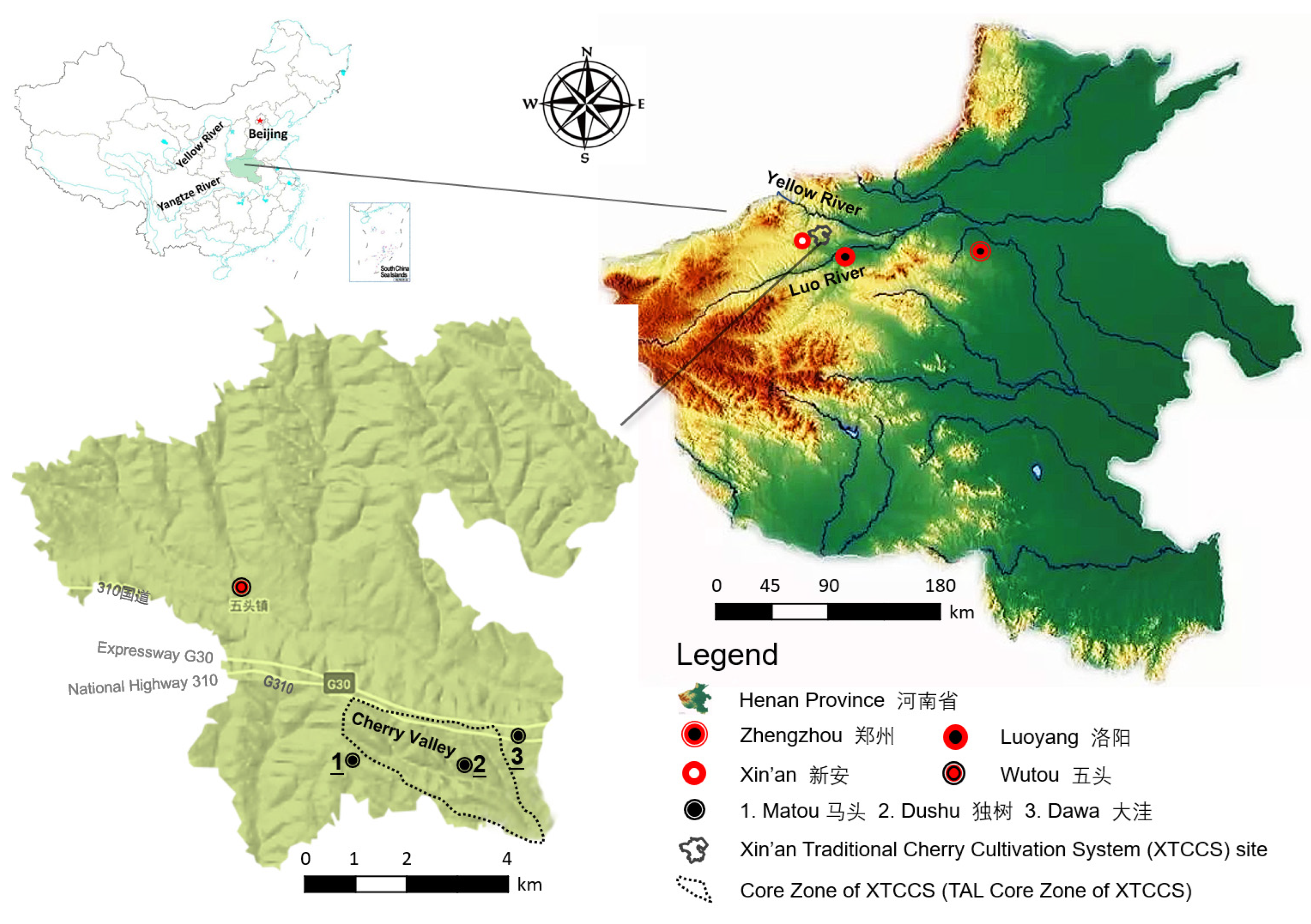
2.1. Study Area

The XTCCS (112°10′5″–112°19′9″ E, 34°42′44″–34°49′27″ N) is situated in Wutou Town, Xin’an County, Luoyang City, and in the loess hilly and gully areas of the He Luo National Cultural Ecology Reserve (Figure 1). It is a traditional forestry system with historical and cultural value. The system is 89.5 km2 in area, covering 27 villages. The altitude is 220–410 m, and the terrain slope is relatively gentle. The climate belongs to the continental monsoon climate of the northern warm temperate zone, with sufficient sunlight, mild climate and four distinct seasons. The average annual temperature is 14.5 °C, the average annual sunshine hours are 2186.9 h, the average annual total solar radiation is 115.2 kcal/cm2, the average annual frost-free period is 216 d, and the average annual precipitation is 624.5 mm. Precipitation is unevenly distributed in time and space, and drought often occurs.
A 17-km long cherry orchard called “Cherry Valley” was historically formed in the southeastern loess valleys of the county. The record of cherry cultivation began in the Eastern Han Dynasty (25–220 A.D.). Since this dynasty, the cherry fruits produced had always been a palace tribute. In the Tang Dynasty (618–907 A.D.), the Emperor Tai Zong, the only female Emperor Wu Zetian, and the celebrated poet Bai Juyi all wrote poems praising these cherries and cherry trees. Li Shizhen (1518–1593), a Chinese medicine expert in the Ming Dynasty, wrote in his world-famous Chinese pharmacopeia Compendium of Materia Medica (Pinyin: běn cǎo gāng mù; Chinese: 本草纲目) that “The cherries produced around Luoyang are the best”.
In XTCCS, 30 ancient trees over 1000 years old still produce considerable economic benefits and play the main role in shaping the local landscapes. The oldest among them are 1400 years old. Meanwhile, about 2200 ancient trees over 100 years old constitute the large-scale forests. People worship the trees, and numerous folk tales and legends have been told about them. The fruits produced enjoy the titles of “Agri-products Geographical Indications of China” and “Famous Local Products”, and have always been the main source of livelihood for local people.
Historically, the traditional local cherry varieties have been known for their big, tasty, and good-looking fruits, and were loved by royalty, dignitaries, and commoners alike. After the Reform and Opening-up, traditional cherry economy was once in the doldrums. 1992 onwards, some Large Cherry (Chinese: 大粒樱桃) varieties from abroad was introduced and planted in the dry terraces outside the “Cherry Valley”, then a large number of farmlands were changed into Large Cherry orchards. In 2017, the XTCCS was designated as China-NIAHS to enhance its protection and utilization.
In the XTCCS site, the zone (112°15′14″–112°18′33″ E, 34°42′45″–34°44′43″ N) with an area of 7.89 km2 is the Core Zone. Most ancient orchards have been concentrated in this zone, covering most of Matou Village, Dushu Village, and Dawa Village. It is the TAL Core Zone and also the most dominant tourist footprint coverage area within the XTCCS site (averaging 86.3% of the total tourist footprint coverage area of XTCCS for many years). The main purpose of the tourists is to experience the local AHS traditional agricultural landscape.
Since 2010, the government has held the “Xin’an Cherry Economy and Culture Festival” every year (Figure 2). Picking fruits, buying fresh fruits, and visiting ancient trees attract tens of thousands of tourists and citizens every year. After becoming a China-NIAHS, the traditional orchard landscape and rural landscape together have become a widely influential cultural tourism hotspot.

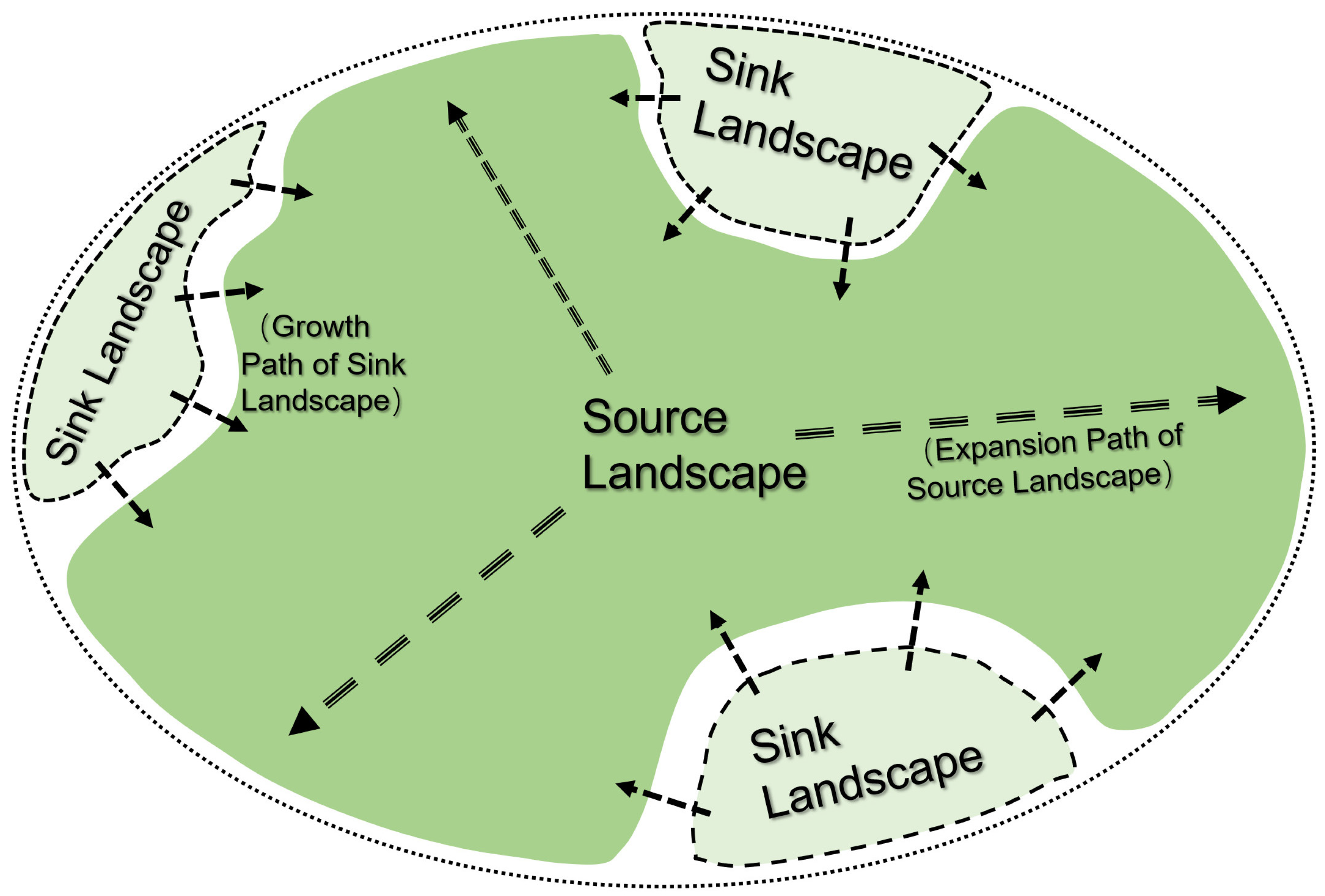
2.2. Introduction to the Source–Sink Landscape Theory

2.2.1. Theoretical Introduction

Linking and integrating landscape pattern analysis with ecological processes analysis is an innovative solution for landscape studies. The “Source–sink” analysis is commonly used in air pollution research, by which the movement direction and pattern of different pollutants in air can be clearly identified. Similarly, for any ecological process, it can be considered as the balance between the source and the sink in space. Thus, the concepts of “source” and “sink” could be employed to the research of landscape pattern and ecological processes [60].
The theory mainly includes: (1) In a region, for a certain ecological process, different landscape types can be divided into two groups: “source” landscape and “sink” landscape. “Source” landscape is the origin of the ecological process, while “sink” landscape refers to the process disappearance. Thus, the key point to distinguish a “source” landscape from a “sink” landscape is to identify the effect of the landscape on the ecological process [60]. (2) A “source” or “sink” landscape is recognized with regard to the specific ecological process. A “source” landscape for an ecological process may meanwhile acts as a “sink” landscape for another ecological process. Therefore, the ecological process should be determined before the “source” and “sink” landscape are defined [60]. (3) For the development of the same ecological process, the contribution of different “source” or “sink” landscapes may vary from each other. It is required to determine the weight of each landscape type on the ecological process [60]. (4) Each “source” or “sink” landscape has its own development direction and trend. The interactions and dynamic balance between the “source” landscapes and “sink” landscapes form the common landscape structure applicable to diverse ecosystems (Figure 3). The source–sink landscape theory was used to explain the law and mechanism of landscape changes. It contributes to making effective landscape conservation measures.

2.2.2. Definition of Relevant Concepts for the Theory’s Application

The TAL Core Zone of XTCCS can be divided into three subzones according to the land use features (Figure 4). (i) Traditional Rural Landscape (TRL) (Figure 5a1,a2). This is centered on ancient orchards and surrounding traditional settlements, covering some agricultural production space near settlements, which is a human–land complex ecosystem landscape with a long history of man and nature having a symbiotic relationship. The ancient cherry orchards are located at the bottom and lower part of the loess valley, which is warm, less windy, and less drought-prone. The traditional dwellings are loess cave dwellings built in the sidewalls near the lower part of the valley, with courtyards outside the cave dwellings. Some of the courtyards also have adobe or tile-roofed houses. Such dwellings are warm in winter and cool in summer, and convenient to get water from the bottom of the valley. (ii) Agricultural (Natural) Ecological Landscape (ANEL) (Figure 5b). This is mainly composed of Large Cherry orchards (appeared and expanded since the middle 1990s), croplands, shrublands, shelterbelts, uncultivated loess hills, and side slopes, which constitute the dry terraced farming system and its surrounding natural environment. The types of crops grown are traditional and include winter wheat, corn, soybeans, sweet potatoes, and peanuts. (iii) Modern Village Landscapes (MVL) (Figure 5c). They are the new emerged landscapes with improvements in traffic conditions, changes in housing conditions, and the development of rural commerce and trade, since entering the modern society. They are intermittently distributed along the traffic lines as patches, or embedded in the matrixes of the first two landscapes. In the past thirty to forty years, with the continuous construction of urban–rural roadways, national highways, and expressways at the upper part of the loess hills, the demand for travel and commerce led some villagers to move out of the valley and build bungalows or multistory houses to live beside the roads. New bazaars were then gradually formed.
In this study, the ecological process denotes the structural and functional changes of the composite ecosystem under the participation of human activities, which is the process of TRL interacting with MVL and ANEL evolution in the past century. During this century, landscapes of rural areas went through a vast change in China due to scientific and technological development, political institution, and economic system changes, as well as the changes in people’s thoughts and values. Taking XTCCS as a case, this study aims to depict and explain the ecological process change that the traditional landscapes competed with the modern ones under a different social background using the source–sink landscape theory. According to the national requirements, China-NIAHS must be protected, rather than allowing them to be swallowed up, transformed, or eliminated by modernized or industrialized agriculture and rural development [67]. XTCCS, as a China-NIAHS, has gone through multiple stages of ecological process changes with the Founding of PRC, the Reform and Opening-up, and the Ecological Civilization Construction, eventually becoming a China-NIAHS and conserved since 2017. This study, on its ecological process, contributes to the understanding of landscape change laws and influence mechanism in rural areas.

2.3. Methodological Framework

The study focuses on exploring the application of source–sink landscape theory in the structure changes and process analysis of the TAL of XTCCS with the changes of the times, which supports the following discussion of TAL conservation strategy. In the past century, China experienced several vast changes in political institutions, scientific and technological development, and developmental policies. TAL changes of XTCCS can also be divided into serval stages due to the influences of these important revolutions. The detailed time nodes need to be identified based on the field surveys. The methodological framework is shown in Figure 6.
(1) Field investigation and analysis. Firstly, base investigations were carried out through multiple channels, such as data access, inquiries, and field trips, to master the physical geography, socio-economic, and cultural conditions of the XTCCS [68]. Secondly, during the fruit picking period in May 2019 and May 2020, in-depth interviews were conducted in the covering villages. The interviewees were 27 village heads and 27 traditional cultivation farmers over 70 years old, who were the only ones having had first-hand experience with traditional agriculture and the TALs. Topics focused on include: (i) How is the XTCCS conserved and utilized? What is the main problem? (ii) What changes have taken place in the XTCCS landscape in the last 100 years? What do you think of these changes? (iii) What is your suggestion for better conservation and utilization of the XTCCS? Then, data about the problems existing in the TAL conservation were sorted and analyzed. Finally, the results were printed on a poster and made into a PPT with photos to facilitate the following display for review.
(2) Focus group meeting. Based on the fieldwork findings, a focus group scheme was employed as a qualitative research technique with local participations [52,69], in order to evaluate and determine key information related to the TAL. The key information includes: (i) problems in the TAL conservation (Session 1); (ii) delimitation and historical zoning of the core zone of TAL (Session 2). The focus group involved relevant stakeholders (Table 1). All stakeholders involved had the ability to influence landscape changes directly or indirectly. The local farmers and governments directly determine the status of cultivation and landscape, while the other stakeholders are affected by the decisions of the formers.
On 20 May 2021, a panel focus group was organized as a one-day roundtable in Xin’an County. Session 1 aimed to extract generally agreed fieldwork findings through collective discussion. One experienced participant was selected as the recorder. After the presentation of the poster and PPT by researchers, every participant freely voiced their views. The results were discussed and revised repeatedly until approved by all. Session 2 proceeded to reach a consensus on determining the TAL Core Zone as the research case of the TAL changes, determined on adopting the zoning form and subzone types in Section 2.2.2 in the subsequent historical zoning, then selected the key historical time nodes, and finally determined the boundary of each subzone at each time node. The work was done by referring to historical remote sensing images, old maps, and old photos borrowed or photocopied from archives, libraries, governments, and native experts. The production years of these references correspond to those time nodes. The process for reaching agreement was the same as in Session 1.
(3) Area calculation. The boundary vectorization and area calculation of the Core Zone and subzones determined by Session 2 at each time node were conducted by ArcGIS. Then, the proportion of each subzone’s area in the total area of the Core Zone at each time node was calculated with Excel.
(4) Source–sink analysis. According to the ecological process determined in Section 2.2.2, the TAL Core Zone was divided into a source landscape and a sink landscape, which changed dynamically due to the influence of internal and external driving factors. Then, the source–sink structure and process of the Zone at each time point was modeled in a graph. The process was reflected in the dynamic interactions between the source landscape and the sink landscape. The source–sink structure and process indicated the succession law and trend of the landscape. According to the law and trend, the conservation strategy of the Zone and the TAL was discussed and proposed from a systematic, holistic, and sustainable perspective.
All the data were recorded by Microsoft Excel 2016, relevant geographic data was processed with ArcGIS 10.5, and the figures were drawn by Microsoft Visio 2016. The landscape space terms are from the China national standard Classification of Land Use Status (GB/T 21010-2017).

3. Results

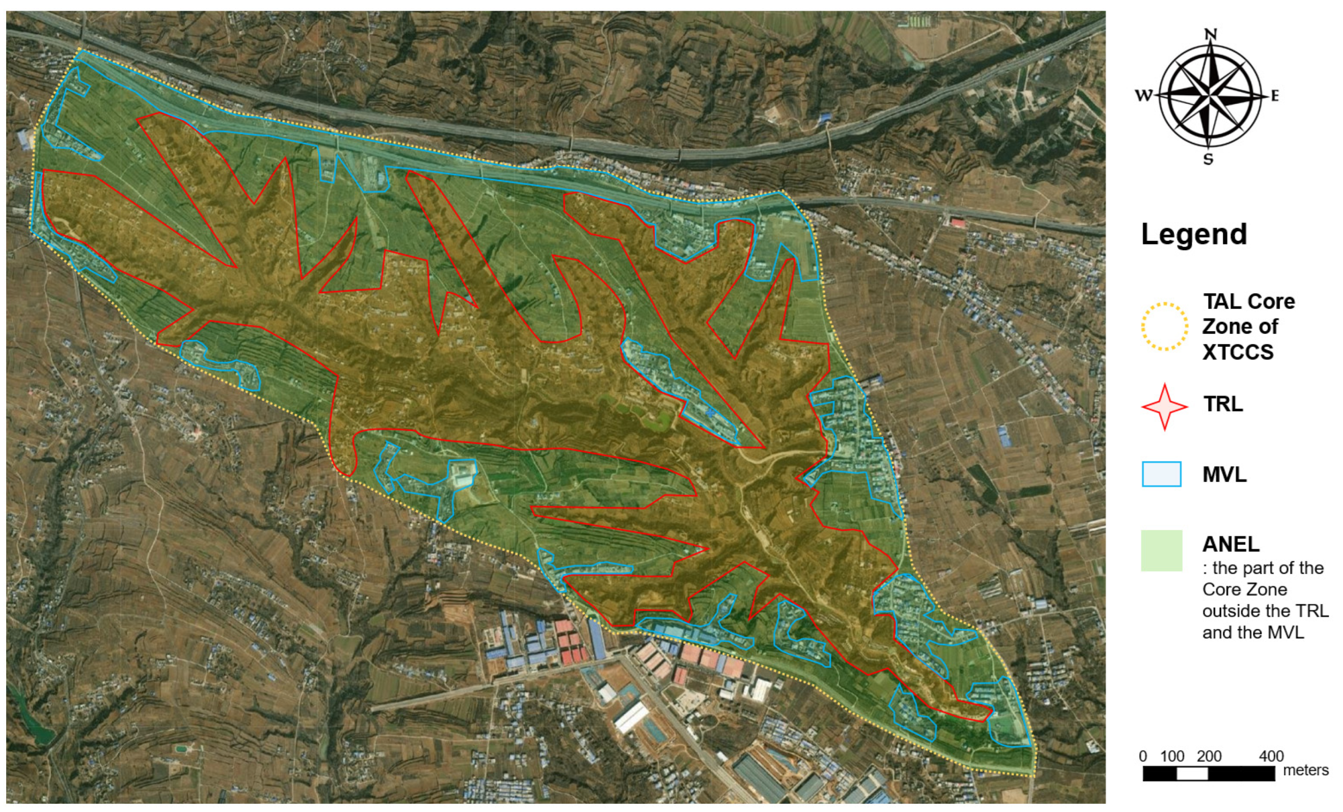
3.1. Change Process of the TAL Core Zone

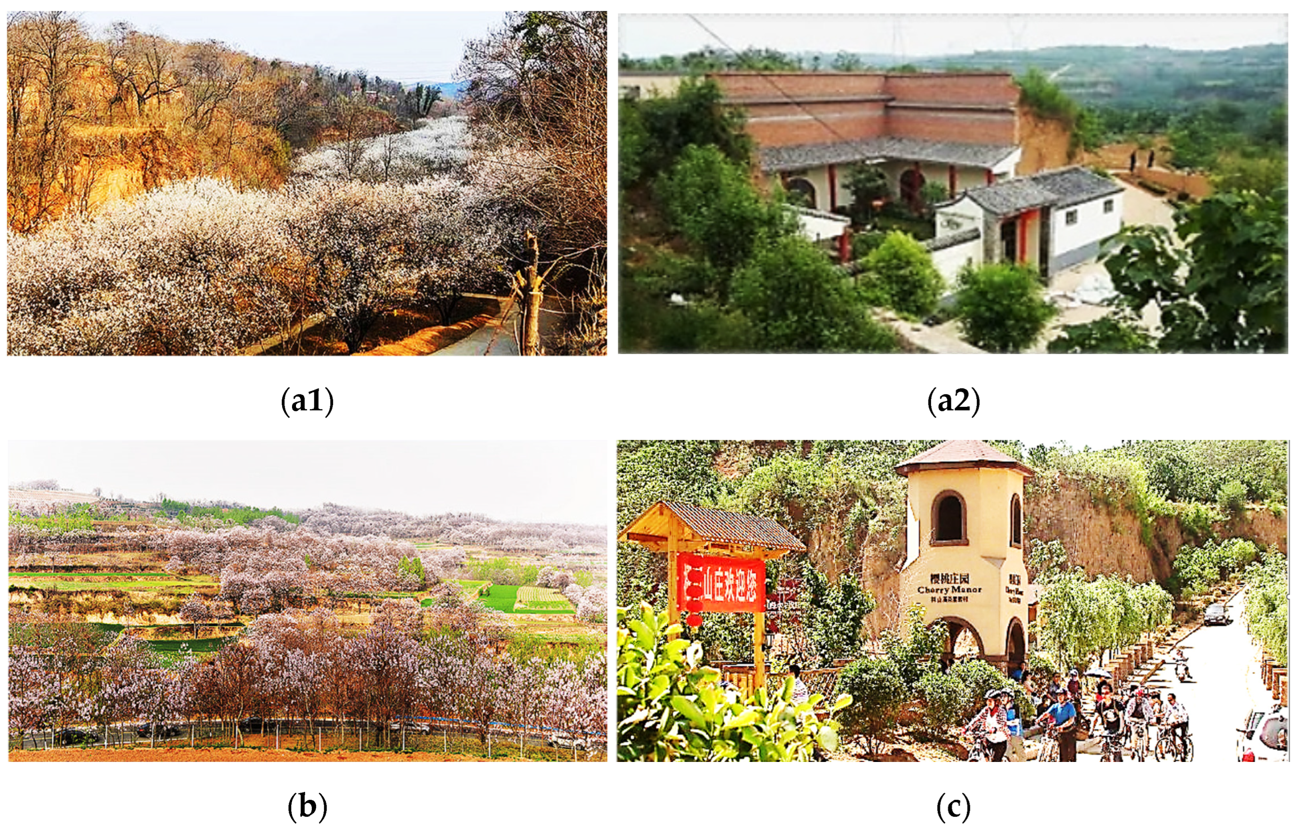
3.1.1. Change Process at Macro Level

The data of the area of each subzone of the TAL Core Zone at each time node are shown in Table 2. The change process of the TAL structure can be reflected in the variation of the proportions of each subzone area in the total area of the Core Zone at five key historical time nodes during 1920–2020. The time nodes were selected to define certain historical stages based on the significant institutional revolution or reforms of China in history (Table 2): (i) From 1920 to 1949, the traditional family-based, self-sufficient, and small-scale peasant economy was good at intensive cultivation and had remained relatively stable, although it seemed closed and conservative; (ii) from 1950 to 1984, Chinese farmers became the owners of land; (iii) from 1985 to 2004, the Household Contract Responsibility System was working steadily; (iv) from 2005 to 2019, agricultural taxes were completely abolished and the New Rural Construction policy had achieved initial results; (v) since 2020, the Rural Vitalization policy have been comprehensively implemented.
As shown in Table 2 and Figure 7, the landscape structure went through a continuous change process during 1920–2020. (i) The TRL continued to shrink, from 67.93% in 1920 down to 49.68% in 2020; the MVL expanded all the time, and their ratio increased from zero in 1920 up to 20.91% in 2020; and the area of ANEL decreased in slight fluctuations, its ratio being relatively stable between 1920 and 2020. (ii) The TRL were slightly eroded or replaced by ANEL and MVL during 1920–1985. (iii) The TRL and ANEL were replaced by MVL with a faster speed from 1985 onwards. The mechanism of these landscape changes needs to be clarified by analyzing the source–sink dynamic mechanism.

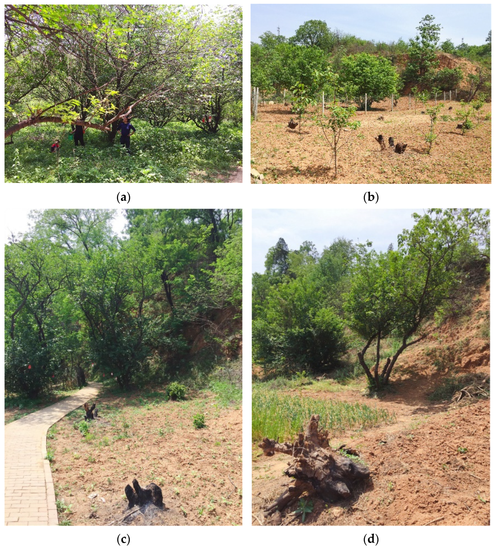
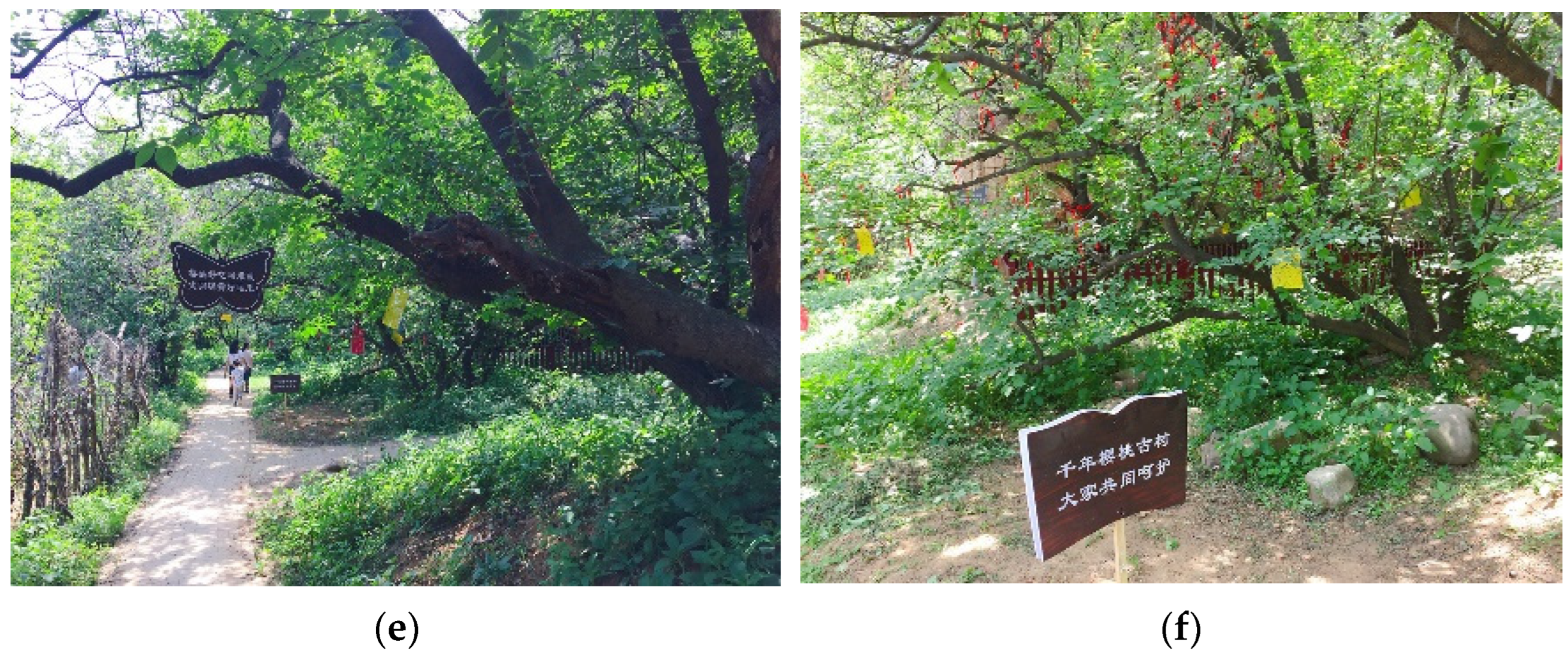
3.1.2. Change Process at Micro Level

From the micro level perspective, many traditional landscapes of cherry orchards have been replaced by new ones or farmlands due to the progress of agricultural technologies and industrialization. For instance, traditional cherry trees were abandoned (Figure 8a) or traditional varieties were replaced by the Large Cherry varieties, whose fruits are large, easy to store and transport, and can be sold at a high price (Figure 8b). Some traditional cherry forests were cut down and transformed into farmland for crops or herbs with a high return on investment (Figure 8c,d). New cultivation models require a lot of irrigation, energy input, and chemical application, which is completely different from traditional cultivation. In recent years, a few traditional cherry trees have been protected by building fences and erecting or hanging protective signs under some policy supports, such as China-NIAHS conservation and ancient and rare trees protection (Figure 8e,f). However, the whole landscapes were still changed to some extent.

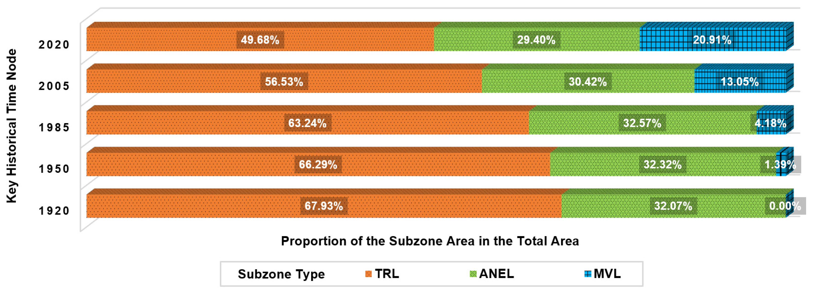
3.2. Source–Sink Structure and Process

3.2.1. Source Landscape and Sink Landscape Identification

The appearance of the TAL stemmed from a dynamic equilibrium between the agricultural (natural) ecological patches and the traditional rural patches in the long-term relation of “as one falls, another rises” and mutual constraints. With the development of modernization, industrialization, and urbanization, more powerful land types, such as industrial lands, factory buildings, transportation lines, gas stations, and tourism facilities, continually emerged and occupied a significant amount of agricultural land or settlement land. Meanwhile, the structure of TRL and agricultural landscape has been changed because these new land use types resulted in local people arranging rural settlements and orchards in places with high accessibility. Therefore, the original equilibrium was broken.
Depending on whether it is conducive to maintaining the aimed ecological process described in Section 2.2.2, both the TRL and the ANEL have been source landscapes, while the MVL have been their corresponding sink landscapes since 1950. Meanwhile, with the historical fluctuations of rural socio-economic conditions in the four stages of the past century, the TRL and the ANEL have often acted as source landscape or sink landscape to each other. As shown in Figure 7 and Figure 9, TRL and traditional ANEL could change into each other. When the grain ration was sufficient for a household or a village and cherries have a high price, some farmland was used to plant cherry trees. At that time, ANEL was the source landscape and TRL was its sink landscape. On the contrary, the traditional orchards were transformed into farmland for planting grains or modern orchards for Large Cherries. At this time, TRL became a source landscape and ANEL was its sink landscape.

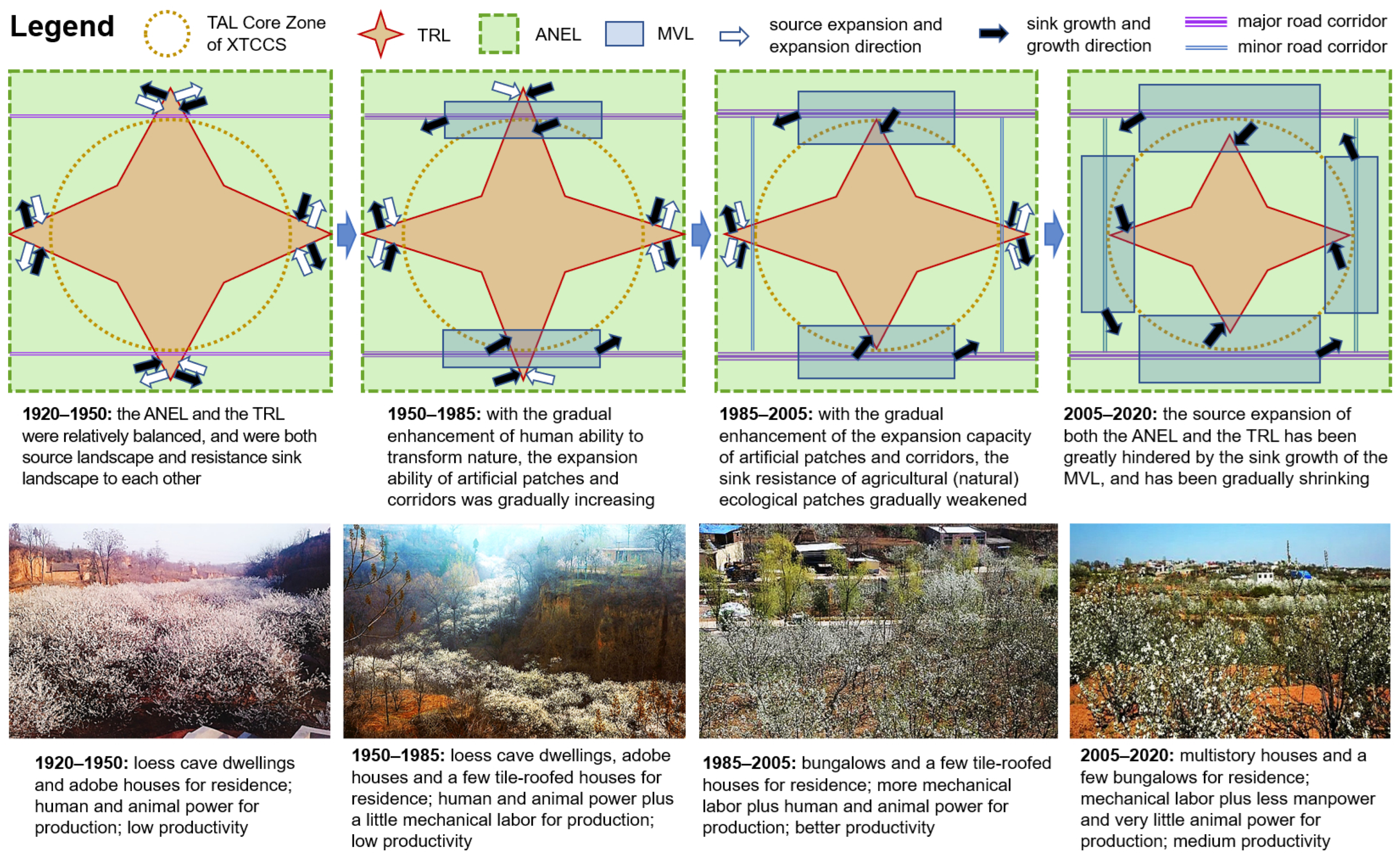
3.2.2. Source–Sink Structure and Process Model and Its Analyses

In history, the residents of the AHS site tended to live together in valleys with relatively good water, soil, and heat conditions, which were also most needed for the growth of Chinese cherry. They formed settlements, mildly transformed the natural environment, and expanded the available land space through natural products gathering and agricultural work including cherry cultivation, underwood cash crop cultivation, and slope grain crop planting. At the time, due to the low level of productivity, the spatial relationship between the settlements and the natural environment was often symbiotic but mutually squeezing. The natural environment plus human production and living landscape units co-existed within the scope of the initial AHS site, and they were also resistance sink landscapes to each other. A resistance sink landscape is a sink landscape that has a certain resistance to the pressure and influence of other external forces outside the source–sink process in which the landscape itself is involved, and thus, is more difficult to be changed by the forces. The resistance comes from multiple internal and external factors interacting to make the sink landscape relatively stable in existence and expansion.
Since entering the modern era, with the gradual enhancement of human ability to transform nature, the expansion capacity of artificial patches and corridors, such as residential areas, production areas, and transportation lines, has been greatly improved, while the sink resistance of agricultural (natural) ecological patches has gradually weakened. Meanwhile, the source expansion of both agricultural (natural) ecological patches and traditional rural patch has been greatly hindered by the sink growth of the constantly emerging artificial landscape types such as commercial buildings, industrial plants, streets, residential areas, and urban–rural roads. Hence, the former two kinds of landscape gradually shrank, while the latter kind gradually expanded. Figure 9 briefly illustrates the source–sink landscape structure and interaction process, and also shows related historical changes.
To be specific, as shown in Figure 9, the ecological process can be explained by the source–sink theory as follows: (1) during 1920–1950, due to the weak power of local communities and the low market demand, agriculture weakly disturbed the XTCCS. The productivity of farmland and orchards just could meet the demand of local villages, county, or prefecture. Therefore, both TRL and ANEL were the source and sink to each other, and they were in balance. (2) During 1950–1985, orchards and farmland were both operated by rural collectives due to the implementation of collective economic institutions. In this stage, traditional orchards were protected well before 1958, the Great Leap Forward. After 1958, part of traditional orchards was reclaimed into farmland for grains due to China implementing the policy of “Take Grain as the Key Link”. ANEL as a sink landscape has a stronger power than TRL as a source landscape. At the same time, some infrastructures and modern buildings occupied farmland and traditional orchards, and thus, MVL presented as a sink landscape and eroded TRL and ANEL. (3) During 1985–2005, collective orchards and farmland were distributed to hundreds of households with the implementation of the Household Contract Responsibility System with remuneration linked to output. Each household adopted a different diverse land use arrangement based on its actual demand. Meanwhile, more modern infrastructures, buildings for commerce and trade, and residences were built along communication lines. Those relatively homogeneous TRL and ANEL began to diminish, and lots of MVL appeared in the matrix made of them. In this process, some TRL and ANEL (source landscape) became MVL (sink landscape), and part of TRL (source landscape) changed into ANEL (sink landscape). (4) During 2005–2020, the process as happened during 1985–2005 continually accelerated and the introduction of foreign cherry varieties brought some diseases, having damaged or killed ancient trees. They led to the increase of non-forest land. However, the traditional orchards and traditional residences became protected to some extent, owing to the rise of the cultural tourism economy of the “Cherry Valley” since 2010 and China-NIAHS conservation since 2017. Therefore, the speed of TRL (source landscape) changing into ANEL and MVL (sink landscape) has been lowered but not stopped.

4. Discussion

This study focused on the model construction of the dynamic spatial logical relationship of the TAL components, and revealed the landscape structure and process through analyzing the evolution of the model, so as to provide technical guidance and risk warning for the landscape conservation and sustainability improvement of AHS sites. After a series of fieldwork and analysis, the study found the problems and obstacles in the conservation and development of the TAL of XTCCS. On this basis, we conducted the source–sink landscape analysis of the TAL Core Zone, figured out the landscape process, and established source–sink landscape structure and process model. Then, we had a general understanding of the source–sink spatial relationship, process dynamics, and succession direction of the TAL. Based on these, a discussion was conducted as follows.

4.1. The TAL Changes Manifest the Human–Land Relationship Changes

Agriculture is a process of people’s cognition, development, utilization, and transformation of land productivity. It has been going on across the history of civilization and has caused a significant imposed change on the Earth’s ecosystem, so that Holocene environments are by no means in a state of equilibrium [1,70]. Early farmers paid attention to adapting and conforming to natural forces, and formed a wealth of eco-wisdom that can stand the test of time. In China, the autochthonous eco-wisdom makes people pay attention to the cultivation and practice of ecological morality, such as ecological conscience, ecological responsibility, and ecological consciousness [71], causing them to apply ecological technologies to make agriculture a sustainable, green, and circular regeneration system [41,72], and thus, promoting the realization of the equilibrium between ecological development and cultural development and benefiting social stability. Then, the ecological landscapes and cultural landscapes of the local agricultural system can be integrated and preserved to become a living, multi-functional AHS with marked local characteristics.
In history, traditional agriculture and TALs were always of great importance [72]. It has been proven that support for traditional farming, landscape diversification, and small-scale agricultural management is vital for enhancing the values of rural areas [73]. However, in XTCCS, modernity and tradition are in conflict. When the villages encountered modernization, externally driven biological and cultural diversity crises began to occur to the TAL, as has happened to the riverscapes [74]. The market-orientation Large Cherry industry continued to put pressure on the survival and development of the China-NIAHS and its landscapes, leading to problems such as ancient orchards shrinking and TAL structure changes. The occurrence and expansion of these crises might be mainly due to the loss or neglect of local traditional eco-wisdom. The comparative economic benefit of Large Cherry industry drove people to no longer highlight the internal regenerated circulation and integral equilibrium of local ecosystem. The overloaded input of agri-chemicals and output of local raw materials made the TAL lose local unique characteristics. Moreover, the new orchards and farmlands do not look much different from many others around the world, after the land leveling, ecological modification, and standardized planting commonly adopted by modern technology. Rapidly growing urbanization has also put constant pressure on TRL to become broken. Additionally, ancient forests were decreasing, century-old trees were threatened, and the long-standing TAL was changing. At the time, the human–land relationship was tense. Fortunately, in order to reverse the TAL change trends from heterogeneity and internal diversity to homogeneity and singleness, the Chinese government has issued corresponding AHS conservation decrees [75]. Nowadays, China places high hopes on returning to the harmony of human–land relations. The world also has such expectations, as pursued by the 2030 SDGs [22,28]. The vision is also expressed in the resolutions of the CBD COP15 (2021) advocating “to build a shared future for all life on earth” [76]. Therefore, experts increasingly agree that TALs and AHS should be fully conserved rather than abandoned. However, how do we conserve the TALs?

4.2. Source–Sink Structure and Process Reveals the TAL Change Mechanism

For a TAL, adaptive conservation is necessary, because each TAL often has a long history of evolution and a complex structure, is in a complicated geographical environment, and is rich in complex internal changes [56,58]. This also determines that it is necessary to figure out the historical changes of the TAL, which provides a background and base of the TAL and guides its adaptive conservation [58,59]. This study used source–sink landscape theory to reveal the centennial ecological process changes, which is a new exploration compared with existing studies of applying the ecological process for a short time. In this case study, the historical law of human activities disturbing the natural-economic-social composite ecosystem and ecosystem’s reactions and feedback among it can be detected. Therefore, we can positively optimize human intervention activities in sub-landscape types. Besides, compared to the source–sink analysis of TRL conducted by Xiong et al. (2019) [64], this study has a similar theoretical basis, but a different research and analysis framework. The uniqueness of this study is that in the analysis of the historical change process of TAL from 1920 to 2020, the integration of landscape structure evolution analysis and process dynamics analysis is realized, and the model expression is carried out. Meanwhile, compared to the published work on source–sink analysis of geographical landscapes [62,63], this study has revealed and simulated the source–sink interaction process dynamics of complex rural landscapes in much more detail, which is an improvement.
The establishment and analysis of the source–sink landscape structure and process model enables researchers to understand the internal and external environment of the AHS, as well as the specific structure and interaction process of the TAL components. Underlying the source landscapes and sink landscapes, there were driving factors such as market, policies, urbanization, depopulation, modernization, preservationism, nativism, ruralism, etc., and the factors’ dynamic combinations in different historical periods. The source–sink interaction mechanism caused by the games and/or complementarities among various driving factors helps to make the dynamic change process of the TAL clear. The specific processes of these games and/or complementarities are explored later.
These results of source–sink analysis of the TAL Core Zone are also applicable to the whole TAL, because the two are similar in structure and process to a certain extent. Around the core of ancient cherry forests distributed in strips in narrow and long Wutou valleys, AHS has some geographical distribution homogeneity within its scope. Then, the above findings have laid a foundation for exploring the dynamic, self-feedback, flexible, and adaptive conservation strategy of both the TAL Core Zone and the whole TAL.

4.3. TAL Conservation Needs to Conform to the Source–Sink Structure and Process

The TAL has been in danger. As a traditional advantageous and characteristic agro-system and biocultural system, the XTCCS has been scarce and adaptable. Its large-scale economic output was once the economic pillar of the local area, and its functions, such as germplasm conservation, technology demonstration, ecological conservation, and cultural inheritance, could not be replaced. These formed the basis for its sustainability across history. However, with the development of market economy, some farmers independently transformed the agricultural landscapes and village landscapes to meet the needs of external markets. Modern architectures, new-style production and living facilities, and commercial cultural elements rapidly increased. Moreover, TRL has been impacted by MVL. Since the implementation of China-NIAHS conservation, the high-quality organic agri-products, unique TALs, and ancient trees have attracted attention and favor at home and abroad. Nevertheless, the brand benefit of the AHS has not been strong enough. Additionally, the protection and management effort has not been satisfying. When the market demand weakened due to the traffic restricted during the SARS epidemic (2002–2003), COVID-19 epidemic, and so forth, the economic benefits greatly reduced. For livelihood reasons, some people destroyed ancient trees or traditional landscapes, and cleared the land for short-term profitable production projects, such as planting corn or herbs (Figure 8c,d). Over time, these have led to the structural degradation and traditional feature fading of the TAL, and the cultural severance within the biocultural system has been aggravated, causing serious problems which need to be addressed.
On the whole, in the centennial change process of the TAL, the source and sink landscapes have undergone continuous changes in strength. The TRL has been weakening, the ANEL has been weakening since 1985, and the MVL have been rapidly strengthening since 1950. Therefore, in TAL conservation practice, it is necessary to curb the strong and strengthen the weak accordingly. Meanwhile, it is important to retain the local traditional production and life as much as possible [41,45,54]. The traditional farmers, farming system, and farming culture are the core, essence, and soul of both the AHS and the TAL [43,45,47,51,54,73]. Keeping all of the three well and connecting modernity with tradition is essential to the conservation work of TAL and AHS. In addition, it is found that traditional agricultural production systems and relevant culture are the foundation of rural society and civilization [41,77]. The AHS not only play the production function, but also bear the cultural, ecological, and social functions [67,78]. Hence, TAL conservation should be able to conserve the multi-functions of the AHS and serve the comprehensively balanced rural development.
In combination, the derived conservation strategy and measures should highlight and reflect the sustainable purpose and adaptive principle of promoting the harmonious relationship between the internal elements of the system (TAL integrated with AHS) and the overall balance and stability of the system. In practice, these key adaptive conservation measures may be concluded from reviewing the above source–sink landscape analysis and referring to the AHS conservation experience overseas [52,54,79,80,81]: (i) To expand the scope of the TRL. Presently, the delineation of the ancient forests is not clear, and some key biological communities, cultural landscapes, and production scenes are not included in the core protection space, resulting in a large number of ancient trees not being listed for protection, as damaged, or as habitat damaged. The delimitation of the scope should be as large as possible, so that more things can be protected. Meanwhile, it is necessary to formulate strict conservation and management planning and regulations, and prescribe implementation details with clear and thoughtful considerations for various stakeholders, management levels and time periods. In the zone, it is urgent to establish the AHS Inheritor System, the Incentive and Reward Mechanism for AHS Conservation and Inheritance, and the TAL Conservation System. It is necessary to comprehensively protect the economic interests of local residents, consolidate cultural confidence, and stimulate conscious inheritance. (ii) To activate the energies of the TRL. The TRL has good potential and resources for the development of cultural tourism, nature education, e-commerce, agricultural products processing, sports and leisure industries. and so on. It is urgent to innovate the means to realize impressive advertising, marketing, and publicity, and gain full support of local people, so as to create high-reputation brands of agricultural heritage products, and to launch product series with tasteful appearances, original ecological origin, pure green production process, authentic local flavor, and rich local aesthetic and cultural taste. All these are helpful to promote cultural psychological protection for conserving and inheriting the traditional agrarian culture, preserve the rurality, naturalness, wilds, and local flavor, so as to achieve a harmonious win-win situation between cultural self-confidence and economic self-improvement. (iii) To promote the localization of the artificial landscapes. In the planning and development of the artificial landscapes, it is better to use as many local cultural elements as possible to highlight, brighten, and show off the local cultural characteristics. It is advisable to build a China-NIAHS eco-museum, submit GIAHS applications, and endeavor to become an important regional tourism destination and even cultural landmark. (iv) To guide and encourage social forces to participate in the conservation through nature education. China’s practice over the past decade or so has shown that localized nature education helps to pass on traditional eco-wisdom and promotes urban and rural people to build a close connection with local nature and ecology [82,83]. On this basis, people are happy to increase their local knowledge, strengthening their sense of local pride and local self-confidence. Therefore, in conservation efforts, nature education can be used to promote people’s spontaneous appreciation of local ecosystems, natural resources, and TALs, so that people can plan the conservation and utilization of various landscapes and heritages with a more long-term, scientific, and sustainable perspective, and thus, proactively promote the sustainable development of the rural areas. The measures are shown here for verification and reference; at the same time, we hope these measures will trigger extensive criticism and discussion on the adaptive conservation of TALs.
Factually, all over the world, traditional orchard landscapes in hilly areas are often typical representatives of TALs with a long history (because fruit trees can usually span history and exist for a long time) [84,85]. Some of these orchards have been designated as AHSs, because they integrate the local, surviving, and self-reliant rural economies with the local biocultural systems and preserve these integrities. However, due to impacts of globalization and modernization in the past century, most TALs, including these orchard landscapes, have been increasingly influenced by irregular, mercenary, and powerful external economic forces. Over time, with the passive adaptation of traditional production relations to new productive force factors, cultural severance gradually occurred in these biocultural systems. Once the support from local traditional culture was lost, these TALs soon lost their stability and started to shrink or be abandoned, and unsustainability appeared. The research cases on these aspects [16,56,57,58] can provide evidence for the practicality of the conclusions of this study. The studies on AHS landscapes [13,45,46,47,51,52] are also basically consistent with this study in the laws found. Therefore, the theory and method of this study can be used as a reference for other studies on TAL and AHS, and the adaptive conservation strategy of TAL proposed in this study can also be applied to other TAL conservation practices to a large extent.

5. Conclusions and Recommendations

5.1. Conclusions

Globally, it is urgent to seek the path of sustainable agricultural development. Modern agriculture has caused the decrease of agricultural landscape diversity and cultural diversity, and resulted in tensions between human and land. It is known that some long-standing TALs help to maintain a harmonious human–land relationship, so as to obtain the local spontaneous conservation and sustainable utilization. The Xin’an Traditional Cherry Cultivation System, a China-NIAHS in the birthplace of Chinese civilization, is an ancient orchard cultivation system with a unique TAL. Historically, the source landscapes and the sink landscapes in the TAL were relatively balanced because the ANEL and the TRL were both a source and a resistance sink to each other. The TAL changed less and the ancient forests were well preserved. With the development of globalization, modernization and urbanization, especially from 1985 onwards, the source expansion ability and sink resistance of both TRL and ANEL have been greatly hindered by the sink growth of MVL. Thus, the TRL gradually shrank, a cultural severance gradually occurred in the biocultural system, and the TAL increasingly experienced structural degradation and traditional feature losses. The structural change process of the TAL could be revealed in the interaction and game between the source landscapes and the sink landscapes. The derived source–sink landscape structure and process model helps to understand the historical changes, process dynamics, and internal structure of the TAL from an innovative dynamic analysis perspective. All of these lay the foundation for adaptive conservation of both the TAL and the whole AHS, and are of reference value for other research, conservation, and utilization practices of TAL.

5.2. Recommendations

AHS conservation can be started from adaptively conserving the TAL and its components: (i) To recognize the core position of TRL in TAL. It is vital to enlarge the protection scope of TRL as much as possible, establish the conservation, compensation, and reward systems, strengthen research and rigorous protection to avoid the landscape from shrinking, so as to prevent the regional agrarian culture from losing its foundation and carrier of inheritance, and avoid the local rurality, naturalness, and agricultural characteristics from disappearing. (ii) To activate the energies of the TRL. It is urgent to foster high-profile AHS product brands, develop brand products with impressing appearances, authentic local flavor, native eco-cultural connotations, and other attractions, fully improve the economic benefits of local residents, consolidate cultural confidence, and stimulate conscious conservation and responsible utilization. (iii) To cure the cultural severance of the artificial landscapes. People should use as many local cultural elements as possible to highlight the local characteristics and uniqueness, as well as construct an AHS eco-museum, strengthen tourist attractions, and apply for GIAHS enrollment, so as to build a well-known cultural landmark. (iv) To introduce, encourage, popularize, and deeply develop localized natural education activities. This measure can facilitate urban and rural people promoting their awareness, appreciation, mastery, and love of local biocultural resources and traditional eco-wisdom, which is conducive to the benign and large-scale development of eco-industrial clusters, thus promoting the ecological civilization construction and rural vitalization.

Author Contributions

Conceptualization, M.L.; methodology, M.L.; software, M.L. and Y.Z.; validation, C.M. and J.C.; formal analysis, Y.Z.; investigation, M.L.; resources, L.H.; data curation, M.L.; writing—original draft preparation, M.L.; writing—review and editing, Y.Z.; visualization, M.L.; supervision, C.M. All authors have read and agreed to the published version of the manuscript.

Funding

This research was funded by the Youth Program, Humanities and Social Sciences Research Project of the Chinese Ministry of Education in 2017 (17YJCZH090), the Cultural Research Special Program of the Promoting Culture Project of Henan Province, China (2022XWH120), the National Natural Science Foundation of China (42171186), the Major Program of the Key Research Base of Humanities and Social Sciences of the Chinese Ministry of Education, the Conservation and Utilization of Xia and Shang Civilizations and Agricultural Heritage Systems in the Yellow River Basin and the Agricultural Science and Technology Innovation Program (10-IAED-04-2022; 10-IAED-ZD-02-2022).

Data Availability Statement

Not applicable.

Acknowledgments

We gratefully appreciate the productive suggestions from editors and anonymous reviewers and would like to give our thanks to them. We gratefully acknowledge the Xin’an and Wutou governments, the interviewed native experts, and the villagers live in the China-NIAHS site for their supports.

Conflicts of Interest

The authors declare no conflict of interest.

References

  1. Trisos, C.H.; Merow, C.; Pigot, A.L. The projected timing of abrupt ecological disruption from climate change. Nature 2020, 580, 496–501. [Google Scholar] [CrossRef]
  2. Foley, J.A.; DeFries, R.; Asner, G.P.; Barford, C.; Bonan, G.; Carpenter, S.R.; Chapin, F.S.; Coe, M.T.; Daily, G.C.; Gibbs, H.K.; et al. Global consequences of land use. Science 2005, 309, 570–574. [Google Scholar] [CrossRef] [Green Version]
  3. Diffenbaugh, N.S.; Burke, M. Global warming has increased global economic inequality. Proc. Natl. Acad. Sci. USA 2019, 116, 9808–9813. [Google Scholar] [CrossRef] [Green Version]
  4. Tilman, D.; Clark, M.; Williams, D.R.; Kimmel, K.; Polasky, S.; Packer, C. Future threats to biodiversity and pathways to their prevention. Nature 2017, 546, 73–81. [Google Scholar] [CrossRef]
  5. Newbold, T.; Hudson, L.N.; Hill, S.; Contu, S.; Lysenko, I.; Senior, R.A.; Börger, L.; Bennett, D.J.; Choimes, A.; Collen, B.; et al. Global effects of land use on local terrestrial biodiversity. Nature 2015, 520, 45–50. [Google Scholar] [CrossRef] [Green Version]
  6. Fowler, P. World heritage cultural landscapes, 1992–2002: A review and prospect. In Cultural Landscapes: The Challenges of Conservation; WHC, Ed.; UNESCO World Heritage Centre: Paris, France, 2002; pp. 2–6. [Google Scholar]
  7. Dietz, K.; Engels, B. Analysing land conflicts in times of global crises. Geoforum 2020, 111, 208–217. [Google Scholar] [CrossRef]
  8. Dunn, C. Biocultural diversity should be a priority for conservation. Nature 2008, 456, 315. [Google Scholar] [CrossRef] [Green Version]
  9. Kelly, R.; Macinnes, L.; Thackray, D. The Culture Landscape Planning for a Sustainable Partnership between People and Place; ICOMOS-UK: London, UK, 2000; pp. 31–37. [Google Scholar]
  10. Sarmiento-Mateos, P.; Arnaiz-Schmitz, C.; Herrero-Jáuregui, C.; Pineda, F.D.; Schmitz, M.F. Designing protected areas for social-ecological sustainability: Effectiveness of management guidelines for preserving cultural landscapes. Sustainability 2019, 11, 2871. [Google Scholar] [CrossRef] [Green Version]
  11. Antrop, M. Why landscapes of the past are important for the future. Landsc. Urban Plan. 2005, 70, 21–34. [Google Scholar] [CrossRef]
  12. Schmitz, M.F.; Herrero-Jáuregui, C. Cultural landscape preservation and social–ecological sustainability. Sustainability 2021, 13, 2593. [Google Scholar] [CrossRef]
  13. Li, Q.; Wumaier, K.; Ishikawa, M. The spatial analysis and sustainability of rural cultural landscapes: Linpan Settlements in China’s Chengdu Plain. Sustainability 2019, 11, 4431. [Google Scholar] [CrossRef] [Green Version]
  14. Liu, C.; Xu, M.; Liu, P.; Zeng, F. Cultural landscape protection compensation model of traditional villages and its application in Xiangxi. Acta Geogr. Sin. 2020, 75, 382–397, (In Chinese with English abstract). [Google Scholar]
  15. Kobori, H.; Primack, R.B. Participatory conservation approaches for satoyama, the traditional forest and agricultural landscape of Japan. Ambio 2003, 32, 307–311. [Google Scholar]
  16. Gobster, P.H. Re-wilding Europe’s traditional agricultural landscapes: Values and the link between science and practice. Landsc. Urban Plan. 2014, 126, 65. [Google Scholar] [CrossRef]
  17. Yang, Y.; Hobbie, S.E.; Hernandez, R.R.; Fargione, J.; Grodsky, S.M.; Tilman, D.; Zhu, Y.; Luo, Y.; Smith, T.M.; Jungers, J.M.; et al. Restoring Abandoned Farmland to Mitigate Climate Change on a Full Earth. One Earth 2020, 3, 176–186. [Google Scholar] [CrossRef]
  18. FAO. FAOSTAT. Available online: http://www.fao.org/faostat/en/#data (accessed on 26 August 2022).
  19. Beltran-Pea, A.A.; Rosa, L.; D’Odorico, P. Global food self-sufficiency in the 21st century under sustainable intensification of agriculture. Environ. Res. Lett. 2020, 15, 095004. [Google Scholar] [CrossRef]
  20. Mishra, A.; Zilberman, D.; Bruno, E. Compound natural and human disasters: Managing drought and COVID-19 to sustain global agriculture and food sectors. Sci. Total Environ. 2021, 754, 142210. [Google Scholar] [CrossRef]
  21. Foley, J.A.; Ramankutty, N.; Brauman, K.A.; Cassidy, E.S.; Gerber, J.S.; Johnston, M.; Mueller, N.D.; O’Connell, C.; Ray, D.K.; West, P.C.; et al. Solutions for a cultivated planet. Nature 2011, 478, 337–342. [Google Scholar] [CrossRef] [Green Version]
  22. UN. Transforming Our World: The 2030 Agenda for Sustainable Development. Available online: https://sdgs.un.org/2030agenda (accessed on 1 September 2022).
  23. FAO. Tracking Progress on Food and Agriculture-Related SDG Indicators 2021: A Report on the Indicators under FAO Custodianship. Available online: http://www.fao.org/sdg-progress-report/en/ (accessed on 2 September 2022).
  24. FAO. Transforming the World through Food and Agriculture-FAO and the 2030 Agenda for Sustainable Development. Available online: http://www.fao.org/3/ca5299en/ca5299en.pdf (accessed on 1 September 2022).
  25. FAO; IFAD; UNICEF; WFP; WHO. The State of Food Security and Nutrition in the world 2020. Transforming Food Systems for Affordable Healthy Diets. Available online: http://www.fao.org/3/ca9692en/online/ca9692en.html#chapter-Key_message (accessed on 3 September 2022).
  26. Zuo, L.; Zhang, Z.; Carlson, K.M.; MacDonald, G.K.; Brauman, K.A.; Liu, Y.; Zhang, W.; Zhang, H.; Wu, W.; Zhao, X.; et al. Progress towards sustainable intensification in China challenged by land-use change. Nat. Sustain. 2018, 1, 304–313. [Google Scholar] [CrossRef]
  27. Tamburini, G.; Bommarco, R.; Wanger, T.C.; Kremen, C.; Van der Heijden, M.G.A.; Liebman, M.; Hallin, S. Agricultural diversification promotes multiple ecosystem services without compromising yield. Sci. Adv. 2021, 6, eaba1715. [Google Scholar] [CrossRef]
  28. FAO. Sustainable Development Goals. Available online: http://www.fao.org/sustainable-development-goals/overview/en/ (accessed on 1 September 2022).
  29. Gunton, R.; Firbank, L.; Inman, A.; Winter, D. How scalable is sustainable intensification? Nat. Plants 2016, 2, 16065. [Google Scholar] [CrossRef] [PubMed] [Green Version]
  30. Rockström, J.; Williams, J.; Daily, G.; Noble, A.; Matthews, N.; Gordon, L.; Wetterstrand, H.; Declerck, F.; Shah, M.; Steduto, P.; et al. Sustainable intensification of agriculture for human prosperity and global sustainability. Ambio 2017, 46, 4–17. [Google Scholar] [CrossRef]
  31. Piao, S.; Ciais, P.; Huang, Y.; Shen, Z.; Peng, S.; Li, J.; Zhou, L.; Liu, H.; Ma, Y.; Ding, Y.; et al. The impacts of climate change on water resources and agriculture in China. Nature 2010, 467, 43–51. [Google Scholar] [CrossRef] [PubMed]
  32. Petherick, A. Agriculture: Drought in China. Nat. Clim. Chang. 2011, 1, 293. [Google Scholar] [CrossRef]
  33. Mccouch, S.; Baute, G.; Bradeen, J.; Bramel, P.; Bretting, P.; Buckler, E.; Burke, J.; Charest, D.; Cloutier, S.; Cole, G.; et al. Agriculture: Feeding the future. Nature 2013, 499, 23–24. [Google Scholar] [CrossRef] [Green Version]
  34. Zhang, F.; Chen, X.; Vitousek, P. Chinese agriculture: An experiment for the world. Nature 2013, 497, 33–35. [Google Scholar] [CrossRef]
  35. Zhang, W.; Cao, G.; Li, X.; Zhang, H.; Wang, C.; Liu, Q.; Chen, X.; Cui, Z.; Shen, J.; Jiang, R.; et al. Closing yield gaps in China by empowering smallholder farmers. Nature 2016, 537, 671–674. [Google Scholar] [CrossRef]
  36. Cui, Z.; Zhang, H.; Chen, X.; Zhang, C.; Ma, W.; Huang, C.; Zhang, W.; Mi, G.; Miao, Y.; Li, X.; et al. Pursuing sustainable productivity with millions of smallholder farmers. Nature 2018, 555, 363–366. [Google Scholar] [CrossRef]
  37. Li, W. Strategic Research on the Conservation and Development of China-Nationally Important Agricultural Heritage Systems; Science Press: Beijing, China, 2016; pp. 4–6. (In Chinese) [Google Scholar]
  38. Jiao, W.; Min, Q. Reviewing the Progress in the Identification, Conservation and Management of China-Nationally Important Agricultural Heritage Systems (China-NIAHS). Sustainability 2017, 9, 1698. [Google Scholar] [CrossRef] [Green Version]
  39. Zhu, Y.; Chen, H.; Fan, J.; Wang, Y.; Li, Y.; Chen, J.; Fan, J.; Yang, S.; Hu, L.; Leung, H.; et al. Genetic diversity and disease control in rice. Nature 2000, 406, 718–722. [Google Scholar] [CrossRef]
  40. Xie, J.; Hu, L.; Tang, J.; Wu, X.; Li, N.; Yuan, Y.; Yang, H.; Zhang, J.; Luo, S.; Chen, X.; et al. Ecological mechanisms underlying the sustainability of the agricultural heritage rice-fish coculture system. Proc. Natl. Acad. Sci. USA 2011, 108, E1381–E1387. [Google Scholar] [CrossRef] [PubMed] [Green Version]
  41. Li, M.; Zhang, Y.; Xu, M.; He, L.; Liu, L.; Tang, Q. China eco-wisdom: A review of sustainability of agricultural heritage systems on aquatic-ecological conservation. Sustainability 2020, 12, 60. [Google Scholar] [CrossRef]
  42. Min, Q.; Zhang, Y.; Jiao, W.; Sun, X. Responding to common questions on the conservation of agricultural heritage systems in China. J. Geogr. Sci. 2016, 26, 969–982. [Google Scholar] [CrossRef] [Green Version]
  43. Zhang, Y.; Li, X.; Min, Q. How to balance the relationship between conservation of Important Agricultural Heritage Systems (IAHS) and socio-economic development? A theoretical framework of sustainable industrial integration development. J. Clean. Prod. 2018, 204, 553–563. [Google Scholar] [CrossRef]
  44. Min, Q.; Zhang, Y. Comparison between Agri-cultural Heritage Systems and Agri-cultural Landscape. J. China Agric. Univ. (Soc. Sci.) 2016, 33, 119–126, (In Chinese with English abstract). [Google Scholar]
  45. Zhang, Y.; Min, Q.; Zhang, C.; He, L.; Zhang, S.; Yang, L.; Tian, M.; Xiong, Y. Traditional culture as an important power for maintaining agricultural landscapes in cultural heritage sites: A case study of the Hani terraces. J. Cult. Herit. 2017, 25, 170–179. [Google Scholar] [CrossRef]
  46. Hu, W.; Zhang, Y.; Wang, W.; Min, Q.; Zhang, W.; Zeng, C. Landscape characteristics and utilization in agro-cultural heritage systems in Lianhe Terrace. Chin. J. Eco-Agric. 2017, 25, 1752–1760, (In Chinese with English abstract). [Google Scholar]
  47. Gao, J.; Lin, H.; Zhang, C. Locally situated rights and the ‘doing’ of responsibility for heritage conservation and tourism development at the cultural landscape of Honghe Hani Rice Terraces, China. J. Sustain. Tour. 2021, 29, 193–213. [Google Scholar] [CrossRef]
  48. Yang, B.; He, L.; Min, Q. Cognition and protection of agricultural heritage from the perspective of cultural landscape: A case study of the Ancient Tea Garden and Tea Cultural System in Shuangjiang, Yunnan. J. Orig. Ecol. Natl. Cult. 2020, 12, 110–116, (In Chinese with English abstract). [Google Scholar]
  49. Hu, Z.; Min, Q.; Liu, P. Identification on cultural landscape of Traditional Rice Terraces in the Southern Area of China. Econ. Geogr. 2018, 38, 180–187, (In Chinese with English abstract). [Google Scholar]
  50. Liu, M.; Xiong, Y.; Yuan, Z.; Min, Q.; Sun, Y.; Fuller, A.M. Standards of ecological compensation for traditional eco-agriculture: Taking rice-fish system in Hani terrace as an example. J. Mt. Sci. 2014, 11, 1049–1059. [Google Scholar] [CrossRef]
  51. Zhang, Y.; He, L.; Li, X.; Zhang, C.; Qian, C.; Li, J.; Zhang, A. Why are the Longji Terraces in Southwest China maintained well? A conservation mechanism for agricultural landscapes based on agricultural multi-functions developed by multi-stakeholders. Land Use Pol. 2019, 85, 42–51. [Google Scholar] [CrossRef]
  52. Gullino, P.; Mellano, M.G.; Beccaro, G.L.; Devecchi, M.; Larcher, F. Strategies for the management of traditional chestnut landscapes in Pesio Valley, Italy: A participatory approach. Land 2020, 9, 536. [Google Scholar] [CrossRef]
  53. Barrena, J.; Nahuelhual, L.; Báez, A.; Schiappacasse, I.; Cerda, C. Valuing cultural ecosystem services: Agricultural heritage in Chiloé island, southern Chile. Ecosyst. Serv. 2014, 7, 66–75. [Google Scholar] [CrossRef]
  54. Chen, B.; Qiu, Z.; Nakamura, K. Tourist preferences for agricultural landscapes: A case study of terraced paddy fields in Noto Peninsula, Japan. J. Mt. Sci. 2016, 13, 1880–1892. [Google Scholar] [CrossRef]
  55. Štefunková, D.; Špulerová, J.; DobrovodskÁ, M.; Mojses, M.; Petrovič, F. Traditional agricultural Landscapes—A model of detailed land use mapping. J. Landsc. Ecol. 2013, 11, 1–21. [Google Scholar]
  56. Lieskovský, J.; Kenderessy, P.; Špulerová, J.; Lieskovský, T.; Koleda, P.; Kienast, F.; Gimmi, U. Factors affecting the persistence of traditional agricultural landscapes in Slovakia during the collectivization of agriculture. Landsc. Ecol. 2014, 29, 867–877. [Google Scholar] [CrossRef]
  57. Lieskovský, J.; Bezák, P.; Špulerová, J.; Lieskovský, T.; Koleda, P.; Dobrovodská, M.; Bürgi, M.; Gimmi, U. The abandonment of traditional agricultural landscape in Slovakia – Analysis of extent and driving forces. J. Rural Stud. 2015, 37, 75–84. [Google Scholar] [CrossRef]
  58. Žarnovičan, H.; Kollár, J.; Falt’an, V.; Petrovič, F.; Gábor, M. Management and land cover changes in the Western Carpathian traditional orchard landscape in the period after 1948. Agronomy 2021, 11, 366. [Google Scholar] [CrossRef]
  59. Kizos, T.; Koulouri, M. Agricultural landscape dynamics in the Mediterranean: Lesvos (Greece) case study using evidence from the last three centuries. Environ. Sci. Policy 2006, 9, 330–342. [Google Scholar] [CrossRef]
  60. Chen, L.; Fu, B.; Zhao, W. Source-sink landscape theory and its ecological significance. Front. Biol. China 2008, 3, 131–136. [Google Scholar] [CrossRef]
  61. Xu, S.; Zhou, H. The landscape dynamics of ‘source’ and ‘sink’ and its quantification method. Res. Soil Water Conserv. 2008, 15, 64–67, 71, (In Chinese with English abstract). [Google Scholar]
  62. Wu, Z.; Lin, C.; Su, Z.; Zhou, S.; Zhou, H. Multiple landscape “source–sink” structures for the monitoring and management of non-point source organic carbon loss in a peri-urban watershed. Catena 2016, 145, 15–29. [Google Scholar] [CrossRef]
  63. Wu, J.; Zhu, Q.; Qiao, N.; Wang, Z.; Sha, W.; Luo, K.; Wang, H.; Zhe, F. Ecological risk assessment of coal mine area based on “source-sink” landscape theory—A case study of Pingshuo mining area. J. Clean. Prod. 2021, 295, 126371. [Google Scholar] [CrossRef]
  64. Xiong, X.; Tang, X.; Ye, H.; Wang, J.; Liu, L. Traditional rural landscape protection and control strategy based on the “source-sink” pattern. Areal Res. Dev. 2019, 38, 120–125, (In Chinese with English abstract). [Google Scholar]
  65. Li, Y.; Liu, Y.; Long, H.; Cui, W. Community-based rural residential land consolidation and allocation can help to revitalize hollowed villages in traditional agricultural areas of China: Evidence from Dancheng County, Henan Province. Land Use Pol. 2014, 39, 188–198. [Google Scholar] [CrossRef]
  66. Seufert, V.; Ramankutty, N.; Foley, J.A. Comparing the yields of organic and conventional agriculture. Nature 2012, 485, 229–232. [Google Scholar] [CrossRef]
  67. Record of China-Nationally Important Agricultural Heritage Systems. Available online: http://www.moa.gov.cn/ztzl/zywhycsl/ (accessed on 3 September 2022). (In Chinese)
  68. He, L.; Min, Q.; Hong, C.; Zhang, Y. Features and socio-economic sustainability of traditional chestnut forestry landscape in China: A case of Kuancheng County, Hebei Province. Land 2021, 10, 952. [Google Scholar] [CrossRef]
  69. Gullino, P.; Devecchi, M.; Larcher, F. How can different stakeholders contribute to rural landscape planning policy? The case study of Pralormo Municipality (Italy). J. Rural Stud. 2018, 57, 99–109. [Google Scholar] [CrossRef]
  70. Brothwell, D. Early history of agriculture. Nature 1975, 255, 368–370. [Google Scholar] [CrossRef]
  71. Li, M.; Jin, X.; Tang, Q. Policies, regulations, and eco-ethical wisdom relating to ancient Chinese fisheries. J. Agric. Environ. Ethic. 2012, 25, 33–54. [Google Scholar] [CrossRef]
  72. Liu, Y.; Duan, M.; Yu, Z. Agricultural landscapes and biodiversity in China. Agric. Ecosyst. Environ. 2013, 166, 46–54. [Google Scholar] [CrossRef]
  73. Špulerová, J.; Petrovič, F.; Mederly, P.; Mojses, M.; Izakovičová, Z. Contribution of traditional farming to ecosystem services provision: Case studies from Slovakia. Land 2018, 7, 74. [Google Scholar] [CrossRef] [Green Version]
  74. Wantzen, K.M.; Ballouche, A.; Longuet, I.; Bao, I.; Bocoum, H.; Cissé, L.; Chauhan, M.; Girard, P.; Gopal, B.; Kane, A.; et al. River culture: An eco-social approach to mitigate the biological and cultural diversity crisis in riverscapes. Ecohydrol. Hydrobiol. 2016, 16, 7–18. [Google Scholar] [CrossRef]
  75. The Central Committee of the Communist Party of China, the State Council of China. Opinions on Comprehensively Promoting rural Revitalization and Speeding Up Agricultural and Rural Modernization. Available online: http://www.gov.cn/zhengce/2021-02/21/content_5588098.htm (accessed on 3 September 2022). (In Chinese)
  76. Kunming Declaration Adopted at COP15. Available online: http://english.www.gov.cn/news/topnews/202110/14/content_WS6167997bc6d0df57f98e1a40.html (accessed on 3 September 2022).
  77. Ministry of Agriculture Announces the Results of the 2016 National Survey of Agricultural Heritage Systems. Available online: http://www.gov.cn/xinwen/2016-12/13/content_5147058.htm (accessed on 3 September 2022). (In Chinese)
  78. FAO. GIAHS around the World. Available online: http://www.fao.org/giahs/giahsaroundtheworld/en/ (accessed on 3 September 2022).
  79. Yiu, E.; Nagata, A.; Takeuchi, K. Comparative study on conservation of agricultural heritage systems in China, Japan and Korea. J. Resour. Ecol. 2016, 7, 170–179. [Google Scholar]
  80. Lee, J.H.; Yoo, H.Y.; Jeon, Y.O.; Choi, S.I.; Youn, W.K. A study on the development of management system for KIAHS (Korea’s Important Agricultural Heritage Systems) sites. J. Korean Soc. Rural Plan. 2018, 24, 13–24. [Google Scholar] [CrossRef]
  81. Kohsaka, R.; Matsuoka, H.; Uchiyama, Y.; Rogel, M. Regional management and biodiversity conservation in GIAHS: Text analysis of municipal strategy and tourism management. Ecosyst. Health Sustain. 2019, 5, 124–132. [Google Scholar] [CrossRef] [Green Version]
  82. China Nature Education Network. Introduction to Nature Education; China Forestry Publishing House: Beijing, China, 2021; pp. 47–48. (In Chinese) [Google Scholar]
  83. Lin, K.; Yong, Y. Natural education: Origin, concept and practice. World For. Res. 2022, 35, 8–14, (In Chinese with English abstract). [Google Scholar]
  84. Šatalová, B. Assessment of Historical Structures of Agricultural Landscape in the Region of Považie. In Research and Management of the Historical Agricultural Landscape: Proceedings from International Conference Vinicné; Dobrovodská, M., Špulerová, J., Štefunková, D., Eds.; ILE SAS: Bratislava, Slovakia, 2011; pp. 149–156. [Google Scholar]
  85. Špulerová, J.; Piscová, V.; Gerhátová, K.; Bača, A.; Kalivoda, H.; Kanka, R. Orchards as traces of traditional agricultural landscape in Slovakia. Agric. Ecosyst. Environ. 2015, 199, 67–76. [Google Scholar] [CrossRef]
Figure 1. Positions of XTCCS and study area.
Land 11 01863 g001
Figure 2. Xin’an Cherry Economy and Culture Festival (2020).
Land 11 01863 g002
Figure 3. The schematic diagram of the source–sink landscape theory.
Land 11 01863 g003
Figure 4. Zoning map of the TAL Core Zone of XTCCS in 2020.
Land 11 01863 g004
Figure 5. Representative landscape of each subzone of the TAL Core Zone: (a1) TRL (ancient cherry orchards); (a2) TRL (traditional settlement); (b) ANEL; (c) MVL.
Land 11 01863 g005
Figure 6. Methodological framework. The dotted line boxes represent the parts of the framework; the red, gray and black arrows indicate the direction of advancement of each part, each subpart and each specific operation step, respectively.
Land 11 01863 g006
Figure 7. Historical proportions of each subzone area in the total area of the TAL Core Zone.
Land 11 01863 g007
Figure 8. Example of TAL change in a corner of Matou Village. The change processes: (a) Inadequate management led to overgrowth of weeds; (b) Some ancient trees were replaced by seedlings of foreign varieties; (c) Some ancient trees and big trees were cut down or destroyed; (d) Some woodlands were converted to farmlands; (e) The ancient forest was relatively well preserved; (f) Key ancient trees were selected for salvage protection.
Land 11 01863 g008aLand 11 01863 g008b
Figure 9. Source–sink structure and interaction process of the TAL Core Zone. The displayed photographs are the cherry landscapes of Matou Village for auxiliary confirmation.
Land 11 01863 g009
Table 1. Number of stakeholders involved in the focus group.
Stakeholder CategoryNumber of Participants
(Number Invited)
Local traditional cultivation farmer6 (6)
Village head5 (6)
Town government department representative2 (2)
County government department representative2 (2)
Academic researcher2 (2)
Major marketers of AHS product2 (3)
AHS product industrial producer2 (2)
Native expert2 (2)
Total23 (25)
Table 2. Historical area of each subzone of the TAL Core Zone.
Key Historical Time NodeArea of the Subzone/km2
TRLANELMVL
19205.362.530
19505.232.550.11
19854.92 2.170.8
20054.581.951.36
20203.922.321.65
Publisher’s Note: MDPI stays neutral with regard to jurisdictional claims in published maps and institutional affiliations.

