Article

Unlocking Land for Urban Agriculture: Lessons from Marginalised Areas in Johannesburg, South Africa

Centre of Applied Research and Innovation in the Built Environment (CARINBE), Faculty of Engineering and the Built Environment, University of Johannesburg, Johannesburg 2092, South Africa
*
Author to whom correspondence should be addressed.
Land 2022, 11(10), 1713; https://doi.org/10.3390/land11101713
Submission received: 25 August 2022 / Revised: 27 September 2022 / Accepted: 28 September 2022 / Published: 2 October 2022

Abstract

:
Amidst the global discourse on the identification of strategic land, there has been a growth in planning support systems aimed at assisting policymakers in unlocking the value of strategic land. Despite planning support systems’ immense benefit of aiding planning, there are limited planning support tools to aid communities in marginalised areas to unlock the value of land. Therefore, this study adopts a GIS-based approach to develop a planning support system to identify, quantify and visualise an index for urban agricultural land in a marginalised area. The proposed solution utilised Greater Orange farm, a marginalised area in the City of Johannesburg, as a case study to inform spatial planning for emerging economies. Using the Charrette visioning process, indigenous knowledge systems were incorporated in formulating the criteria, weights, and rulesets. The results reveal spatial sites ranked through an index where sustainable investment in urban agriculture infrastructure should be targeted. The developed index identifies suitable locations for urban agriculture infrastructure and supporting programs. Furthermore, the solution builds from the existing reservoir of PSS in Southern Africa by demonstrating the potential for planning support systems as sustainable data-based decision-making tools to inform spatial planning. Lessons emerging from this study are that there is an inseparable existential connection between indigenous knowledge systems and contemporary sustainability planning, which is critical for ensuring sustainable development.

1. Introduction

Amidst the global discourse on the identification of strategic land, there has been a growth in planning support systems (PSS) aimed at assisting policymakers in unlocking the value of strategic land. Scholars have outlined that the key to unlocking the full value of strategically located land depends on collaborative efforts from key stakeholders [1,2]. Rittenbruch et al. [3] have also noted that PSSs have filled the void in bridging efforts of manipulating and interpreting spatial datasets, and computer-based simulation models for planning rehearsals aid in saving money, reduce delays, and allow for data-based decision making. Scholars have outlined how PSSs seek to address the contemporary challenges of planning through the provision of data-driven decision support and a feedback system that promotes immersed collaboration that is focused on leveraging geospatial analytics [4,5,6].
However, the employment of a PSS is still not very common, especially in developing countries such as South Africa [7,8]. Due to this limitation in the use of planning support systems, there still exists a knowledge gap on how to unlock strategic land [5,9]. To address such challenges, scholars have advocated the use of emerging technologies such as geographic information systems (GIS) to build capacity and address spatial challenges [4,5]. In the journey to build capacity in developing countries, several planning support systems (PSS) have emerged to assist government officials [5,8]. PSSs pose a valuable solution to addressing spatial challenges that marginalized communities face. Scholars have outlined how GIS-based PSS can be utilised to identify well-located land to inform emerging economies, such as urban agriculture in marginalized areas [10,11]. Emerging economies relate to new economic sectors that diversify economies in marginalized areas.
One such emerging economy is urban agriculture [12]. According to Nino et al. [12], urban agriculture is designed as a practice of farming for domestic or community-scaled food-growing practices. The practice is either for consumption or selling. Washbourne et al. [13] have also outlined that only 6% of Gauteng residents participated in urban agriculture. The majority of those households participated in providing additional food for the household. Nino et al. [12] attributed the low participation in urban agriculture activities to several factors. Notable factors include the lack of adequate access to land for farming; poor access to the market because of limited, inconsistent supply of the produce; and limited accessibility to agricultural infrastructure and water sources, particularly in areas where land is available [9,12,14].
This study, therefore, seeks to unpack the contribution of planning support systems as a critical tool to improve urban agriculture in marginalized areas. This is achieved through initially assessing the contribution of the planning support system in unlocking the strategic land and then developing a criteria ruleset. The remainder of the paper is organized as follows: Section 2 describes the literature related to the study. Section 3 introduces the study area and describes the methodology of criteria identification and the ruleset that informed the analysis. Section 4 presents the results and discussion, while Section 5 presents the lessons learned. Lastly, the conclusion and outline of possible further studies are presented in Section 6.

2. Related Work

2.1. Planning for Marginalised Areas

In developing countries, the debate on sustainable approaches for economic recovery approaches post the COVID-19 pandemic continues unabated. Scholars have outlined that research should inform planning and assist policy and legislative instruments to respond to the call for spatial transformation and integration [15,16]. The United Nations have also outlined the need to focus on human development pillars as part of efforts to improve the quality of life of communities [17,18]. Given this call, there has been a growth in efforts to address challenges faced by previously disadvantaged communities [19]. Previously disadvantaged communities have historically been located far from opportunities. The problem is prevalent in developing countries that suffer from a limited reservoir of tools to assist efforts to address spatial and economic challenges that previously disadvantaged communities face. Consequently, previously disadvantaged communities have been forced to reside in marginalised areas.
Marginalised areas can be described as locations at the periphery of the economic centre and where the residents are socially, economically, and environmentally marginalised [8,9]. Several policies have been introduced in South Africa to address spatial and economic reform. However, due to weak implementation mechanisms, there have been few success stories [20]. A nodal review for the City of Johannesburg outlined the need to address the inequities and disadvantages intrinsic to living in marginalised areas [21,22]. To build on such efforts, several scholars have outlined to achieve this political mandate, strategic planning approaches need to ensure sustainable development in marginalised areas [23,24].
Assessments of marginalized areas in cities such as Johannesburg reveal emerging economic activities that have the potential to modernize the township economy [25,26]. One such notable emerging practice is urban agriculture [27]. Literature has revealed that the practice of urban agriculture has the potential to solve challenges of food security and is also a viable emerging enterprise [8,10]. Likewise, Ferreira et al. [12] have articulated the risks associated with the lack of planning for food security. Given that marginalized areas are at the periphery of economic centres, the need for food security becomes vital [12]. In developing countries, there has been a call for more efforts to address the negative socio-economic effects of the Coronavirus disease pandemic, which drastically affected the quality of life of many communities [28]. Local communities in townships have turned to emerging enterprises such as urban agriculture for food security and to secure a source of income. In urban areas, agricultural activities are ruled by competition and short-term efficiency [29]. Scholars such as Joshua Zeunert and Robert Freestone [30] have mapped the spatial trends of agricultural land planning using geographic information systems for the Sydney Metropolitan in Australia. The tool developed was used to inform strategies to address displaced communities that rely on urban agriculture.
As stated by Bouroche et al. [31], spatial planning tools should address multi-objective optimisation and coordination of historical, current, and predicted spatial data. Scholars in resource management have articulated the importance of indigenous knowledge as the basis for sustainable practices. Mao et al. [32] utilised multiscale geospatial analysis to map spatio-temporal patterns of wetlands and farmlands in China. The findings reveal the potential of GIS-based systems for developing place-based environmental conservation and land management policies. In comparison, Clinton et al. [33] accessed the incorporation of Geospatial ecosystem services estimation for urban agriculture. The study reveals potentially large incentives to incorporate agricultural ecosystems within existing and planned urban areas. This is unpacked through the visualisation of the food–energy–water nexus.
Scholars have referred to indigenous knowledge as a system due to its holistic nature that responds to human interaction with the environment. This is evident in how indigenous knowledge systems (IKS) have sustained indigenous communities for decades as it has been generationally inherited through culture and custom practices [34]. Moreover, IKS is based on practice, and used by local communities to predict situations using site-specific solutions [35,36].
Malapane et al. [14] have also outlined the importance of IKS in the identification of strategic land. As this would ensure efforts of economic recovery in marginalised areas are championed by a vital reservoir of indigenous knowledge. A review of literature on the adoption of IKS in urban areas reverberates the critical role of traditional knowledge systems. Kuyu et al. [37] have also documented the importance of IKS in securing food security, economic growth, and sustainable development.
Notwithstanding the great potential of IKS as a land management strategy, there are challenges associated with its adoption, particularly in urban areas. The challenges are due to the complexities and uncertainties found in urban areas. Son et al. [35] warned that the implementation of IKS requires careful craft to minimise conflicts between several cultures or traditional practices. In such urban environments, there is a need for a collaborative platform that blends various IKSs into a reservoir of knowledge to inform spatial planning. This would lead to the mitigation of risks associated with the lack of planning or the use of inappropriate planning tools [5] and would consequently build on existing efforts to address managing land systems with limited resources [5].

2.2. Planning Support Systems

Studies examining the spatial relationship between IKS and land management are growing [14,35]. Most scholars agree that unlocking the value of land depends on the availability of data management tools to support IKS [14,35]. Local communities, particularly natural-resource-dependent communities, are integral in developing spatial planning tools. The literature reveals a growth in spatial planning tools, namely, planning support systems (PSS), that incorporate IKSs to inform spatial planning. Te Brömmelstroet [38] describes PSS as a collection of computer-based tools that seek to aid planners to achieve various tasks. Accordingly, PSSs can also be understood as a family of planning tools that aim to enhance collaborative planning by focusing on building strategic planning capacity [5,39]. As such contemporary PSSs have emerged as tools for both data processing and collaboration support to address spatial complexities. Similar to emerging digital transformation tools such as Building Information Modelling and the Digital twin, PSSs enable users to gather, manipulate, assess, and store data more efficiently, which has enabled planners to address spatial complexities [38,40,41]. Furthermore, such tools can be used to engage communities from diverse backgrounds in science and environmental planning.
Quan et al. [42] utilized a low-energy urban agriculture system in Atlanta that was based on urban design principles. The developed PSS was used to visualise urban data as informational layers. The findings reveal the potential of PSS for performance analyses for measuring energy and food flows. Deal et al. [43] presented a Web-based portal dynamic-spatial model which sought to evaluate a beneficiaries-based ecosystem in McHenry County, Illinois, United States. The study revealed improvement in community acceptance of PSSs and that the tool should be accessible and provide a direct comparative analysis of different policy or investment scenarios.
Rittenbruch et al. [3] have also noted that PSSs have filled the void in bridging efforts of manipulating and interpreting spatial datasets, and computer-based simulation models for planning rehearsals aid in saving money, reduce delays, and allow for data-based decision making. Compared to other planning systems, PSSs aim to address the challenges of planning through the provision of decision support and a feedback system that promotes immersed collaboration focused on leveraging geospatial analytics whilst also encompassing the entire planning process [4,5,6].
Recently, there has been a lot of debate arising with regard to the direction in which PSSs should develop. Essentially, the argument is that PSSs have become dependent on big data [44], which smaller municipalities do not have access to, as they lack the computer technologies to process this information. Table 1 outlines emerging PSSs in Southern Africa. Such PSSs seek to address seemingly conflicting goals of achieving a balance between complexity and simplicity.
Globally, PSSs have significantly been applied in a number of studies to evaluate communities that have resource-constrained environments (see Table 1). It is because of these benefits that PSSs are now widely being adopted to address spatial challenges. However, in developing counties, there is still a dearth of available tools that can be used to identify strategically located land. The need for a solution is more evident in marginalized areas as these locations have been historically disadvantaged. Such a solution should be developed through a collaborative process with local communities to ensure sustainability, spatial transformation, and community acceptance of the tool.
Although gaining some traction, the use of PSSs to inform urban agricultural activities is still poorly understood, particularly in Southern Africa. The emergence of the digital transformation debate within the built environment reveals the void in planning approaches. This calls for the development of PSSs to aid city authorities in making spatial decisions. Given the limitations for digital transformation within the built environment, it is in this context that there has been a growth in research on PSSs to support urban agricultural activities. As such, PSSs can be used by communities to understand the dynamics of their land to inform strategies to add value to the land [3]. Given the limited PSSs in Southern Africa, there is a need to improve coordination between PSS adopters and PSS implementers and to achieve a balance between control and creativity in order to improve PSS applicability.

3. Materials and Methods
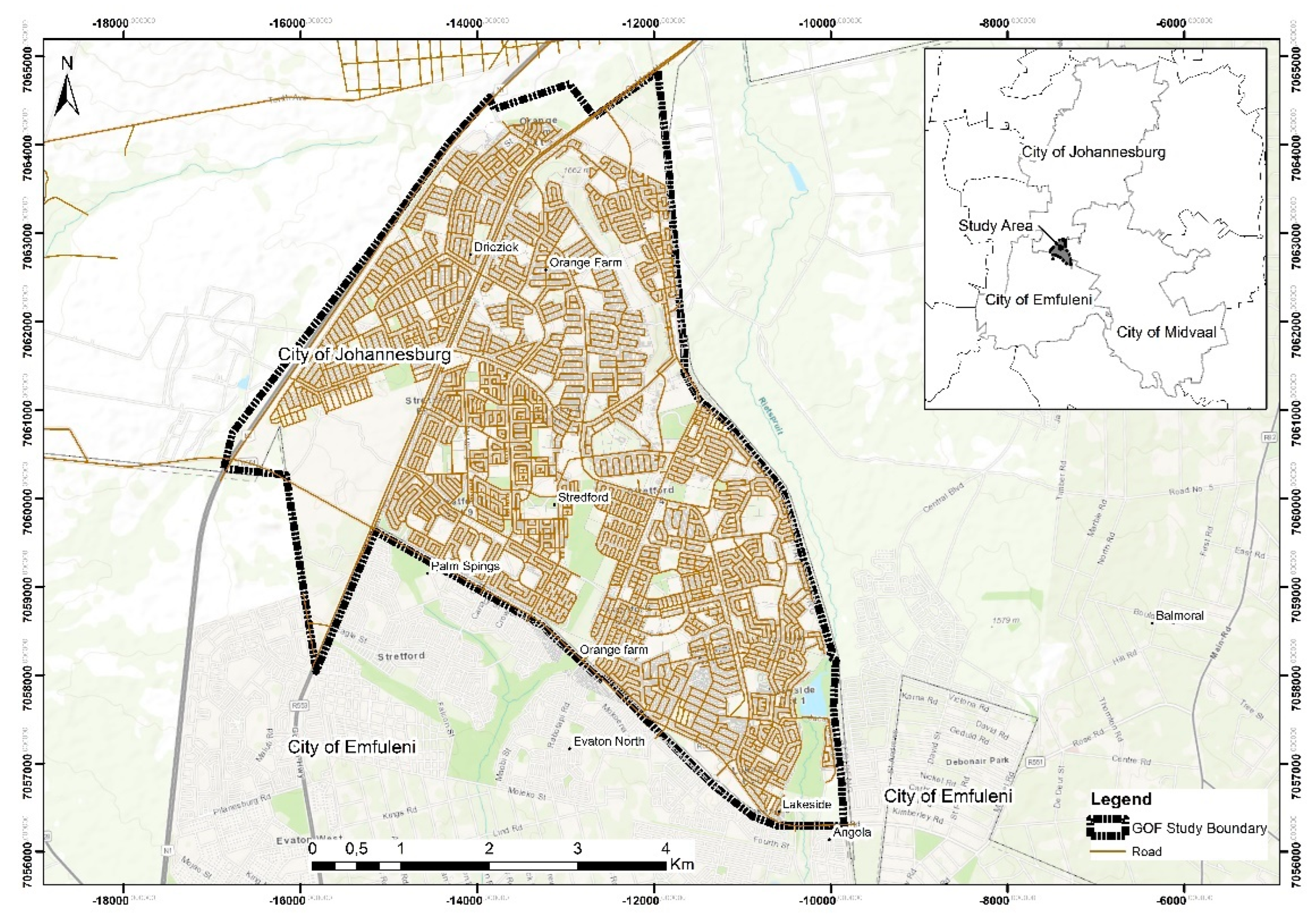
This section provides the road map for spatial analysis to identify strategically located land for improving the quality of life in Greater Orange Farm (GOF). The collaborative approach is a GIS-MCDM tool that seeks to build capacity in local communities to meet SDG 2—Zero hunger—and SDG 11—Sustainable Cities and Communities [49]. The proposed solution builds on previous tools developed [1,5,49].

3.1. Study Area

The focus of the paper is Greater Orange Farm (GOF), which is situated approximately 43 km south of Johannesburg Central Business District (Figure 1). The site covers a surface area of approximately 29 km2. GOF is characterized as one of the biggest and most populous settlements in the city of Johannesburg. As the site is located on the southern boundary of the City of Johannesburg, this has led to the site being marginalised in terms of access to economic opportunities, social amenities, and infrastructure. Due to an increase in the population, there has been a rapid increase in informal settlement development, and this has negatively impacted the existing infrastructure as well as increased the isolation of the community from the necessary socio-economic opportunities.

3.2. Criteria Identification and Assigning Weights

Any efforts to identify and clarify the importance of criteria to inform spatial targeting would need to include the IKS, that is, the ideas and opinions of experts and the local community [14]. Local Urban Agricultural Forum members and SMMEs Forum members were invited to focus group discussions. Each discussion session lasted between 120 and 160 min. The sessions were held at the local community hall. The discussions were moderated to solicit full and active participation of all members. This allowed all attendees to fully express their views and prevented the more talkative ones from dominating the discussions. It emerged that the participants openly and eagerly expressed their knowledge and experiences in urban agriculture and found the inclusion of IKS in the index development as reviving and interesting. Where necessary, guided tours to observe sites of interest in GOF were also facilitated by forum representatives at the end of discussion sessions. Table 2 outlines the profile of the workshop participants. This process also was used to establish the overall vision for GOF.
Initially, a Charrette visioning process was conducted to assess the development opportunities and constraints that arise from the study area [50]. The following outlines the characteristics of GOF:
  • On the eastern side of the study area, mixed-land use, including social amenities and economic activities, is located within accessible and comfortable walking distance from the majority of residences.
  • Regional connectivity is possible via prominent road infrastructure, such as the N1/20, N1/19, R550, Golden Highway, and St. Patrick Road.
  • The community is made up of a mostly semi-skilled workforce.
  • The public realm is mostly in poor condition and needs to be upgraded and maintained.
  • The local economic base is weak, and unemployment is very high. This is also evident by the area displaying a strong linkage with Johannesburg for transportation, employment, and administrative structures.
  • The wetlands in the area are poorly maintained, and in some instances, there is an encroachment of informal housing on the wetlands.
  • High potential agricultural soil, which is polluted, and general poor management of biodiversity areas.
The analysis reveals critical elements that would need to be addressed to improve the economic opportunities in GOF and also contribute to the alleviation of the high levels of poverty and unemployment. During the discussions with the community forums, urban agriculture was identified as a critical emerging economy in GOF. However, due to a lack of planning tools, its practice in GOF was limited. A collaborative process was adopted in the development of the GIS-MCDA framework to unlock the value of land in GOF. Hence, a criterion to identify land for urban agriculture in GOF was developed. A criterion to inform how GOF can achieve urban development and capitalise on existing potentialities was then workshopped using literature on local economic development, smart cities, policies (national, regional, and local), and the needs of the community of GOF as a guide. The criteria were condensed to 10 (see Table 3) so as to reduce complexity and redundancy. Discussions during the Charrette visioning process also ensured the criteria were realistic, transparent, and smart. Consequently, the discussions ensured the criteria set the foundation for future planning in the area and carefully considered all the issues identified by the local community forums.
After delineation of the criteria, the next step was to evaluate the weighting of the criteria against other competing criteria. The community forums outlined the need to ensure tool to enhanced the economic value of GOF while also addressing sustainability issues. It was then recommended to utilize a Group Analytical Hierarchy Process (GAHP) to evaluate the criteria [39,40,51,52].

3.3. Delination of Criteria Rule Sets and Mapping

The delineation of the criteria rule sets was informed by literature and discussions during the workshop. The datasets were obtained from the City of Johannesburg and South African National Land Cover (SANLC). A common geodatabase was created to store the raw data and processed data that were accessible to all the participants. Consequently, the rule sets for each criterion were defined using Table 4.
The next step in identifying the most suitable land for urban agriculture in GOF was to express the rule sets as shown in Table 5 to inform the suitability index for urban agriculture in marginalised areas (as shown in Table 5).

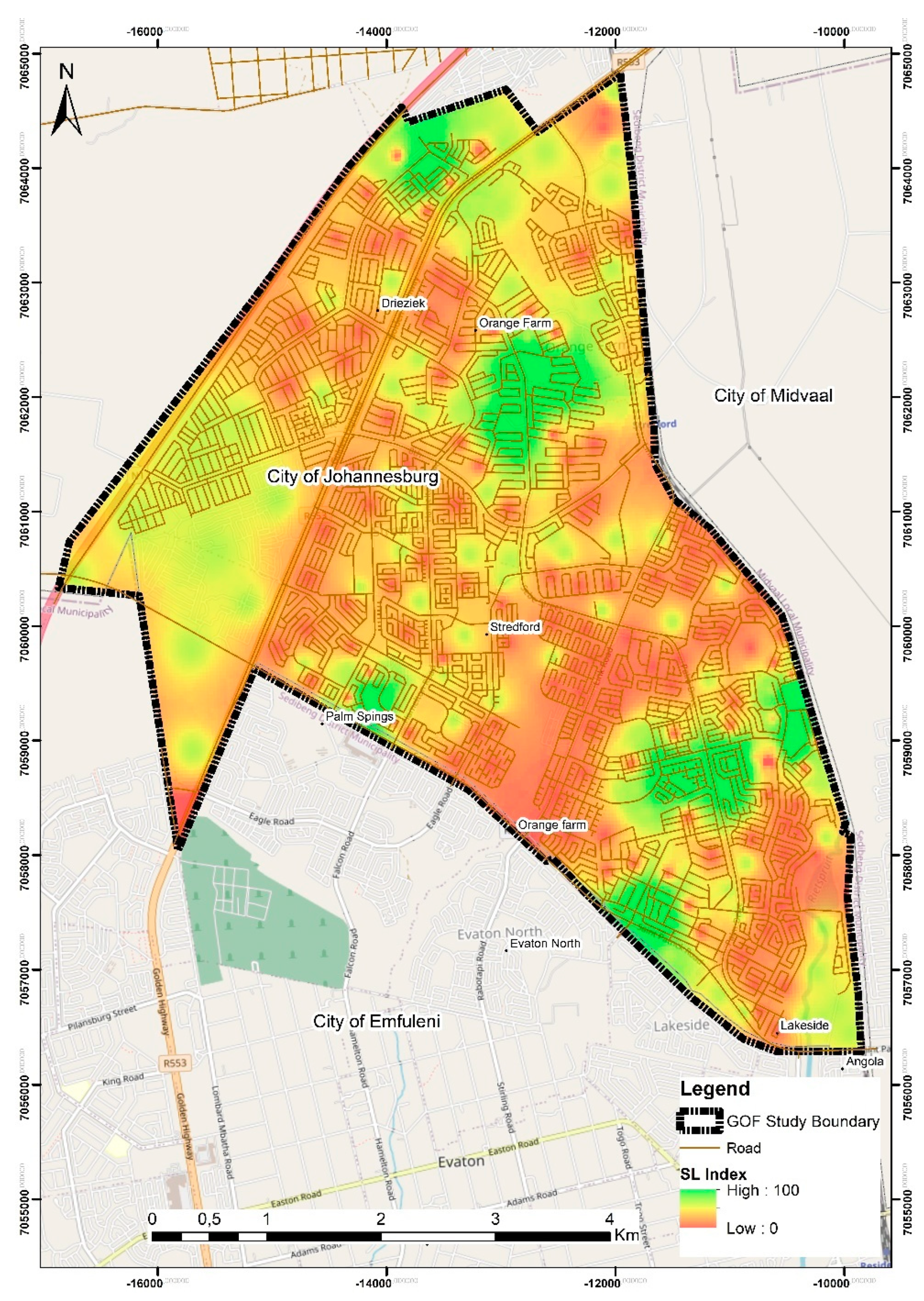
3.4. Computing the Strategic Land Index

To generate the Strategical located land Index, the Geographic Information System operation to Weighted Linear Combination (Equation (1)) was used. The technique has the merit to derive composite spatial maps based on a predefined rule set. Equation (1) was then utilized to compute the land index:
G i = i = 1 n W i j a i b i   c i   d i   e i
where ruleset constraints are expressed as a i , b i ,   c i , d i , and e i ; W i is the weight of each criterion calculated using the GAHP; and n is the number of ruleset criteria. The index was selected because it is risk averse [1]. The index was reclassified from 0 to 100, where 0 is not suitable and 100 is highly suitable [5]. Given the connectivity challenges in GOF, a GPS device was utilised during the field validation to document the characteristics of the land and assess the accuracy of the index.

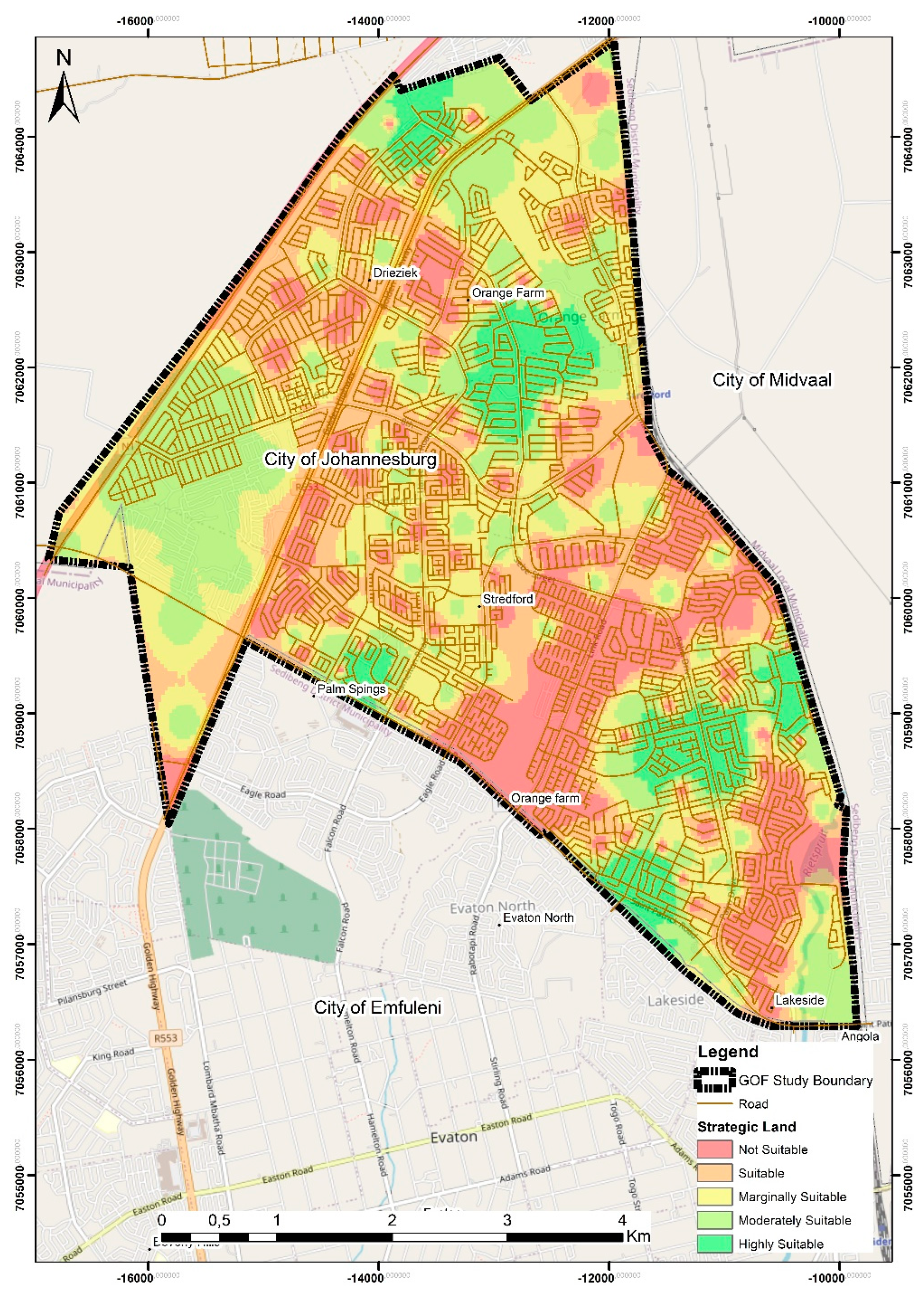
4. Results and Discussion

This section provides the results of the strategic land analysis of GOF for urban agriculture. By focusing on GOF in its entirety, it becomes possible for city officials and residents to have a clearer picture of the potential of the land portions. This allows for a more integrated approach to development planning. The analysis of the land portions is performed with an appreciation of the broader variables that have an impact on development planning in GOF. The choice of focusing on agricultural potential stems from the fact that all of the City of Johannesburg development planning tools prioritise the green economy [58,59]. Urban agriculture has been identified as critical in addressing the triple challenges of unemployment, poverty, and rapid urbanization [58]. Moreover, agriculture has, over the last two decades, proven to be one of the South African government’s priority areas [58]. Figure 2 shows the suitability index for the GOF region. The strategic land index for GOF was used to profile sites using a suitability rank from highly suitable to unsuitable: 14.22 percent of GOF is highly suitable; 15.95 percent is moderately suitable; 10.75 percent is marginally suitable; 10.05 percent is suitable; and 49.03 percent is not suitable for urban agriculture.
The farming activity that has been noted in GOF is through communal gardens and backyard gardens. It is crucial to note that the sites reflected in Figure 2 are only indicative of where to target areas for establishing urban agricultural activities. As such, sites located within the highly suitable and moderately suitable areas were then subjected to on-site observations to validate their suitability more intuitively than quantitative data allows (see Figure 3). While all the sites are within the highly suitable and moderately suitable rank, they require maintenance and upkeep. The suitability ranking correctly designated the Urban Resilience hub as a strategically located land, and the debate remains whether the programs and services offered at the Urban Resilience hub are accessible to all residents of GOF. There is a need for satellite offices of the Urban Resilience hub to be rolled out to other community facilities.
Further cross-validation of marginally suitable and suitable sites reveals that these sites comprise portions of land adjacent to residential properties in the community. Observations reveal the potential of these sites is dependent on the willingness of adjacent landowner’s support and the availability of water sources and support programs. What is apparent from these sites is also the persistence of the community to tap into the urban agriculture economy. Various approaches are being implemented to maximise outputs from the limited land, such as using both organic and chemical farming approaches [56]. Despite these community-based initiatives, what is apparent from the strategic land analysis is the persistence of underdevelopment in GOF. These markers of underdevelopment reflect the challenges of being a marginalised community. Notable challenges include a lack of basic services such as adequate water and infrastructure. The culmination of these absences is abject poverty, unemployment, frustration, and a relatively poor quality of life. Figure 4 outlines urban agricultural activities in marginally suitable and suitable areas.
The GOF Urban Agriculture Forum also articulated that “due to limited economic opportunities urban agriculture is becoming the main source of livelihood for many people in GOF, with approximately over 40% of the community directly relying on agriculture as a means of living”. This high percentage of agriculture activity in GOF has been a result of limited economic opportunities to absorb this fast-growing population in the marginalised area. To this end, the existing community efforts should be harnessed to promote urban agriculture within the region. It is necessary to identify land for economic development so as to ensure that people are settled where there are necessary supporting services and amenities. The strategically located land assessment reveals that the land is mostly located close to built-up areas (see Figure 5). However, there is a need to introduce irrigation facilities and also align these with programs offered through Urban Resilience hub so as to take advantage of the existing agricultural economy in Johannesburg. Also noteworthy is that land portions are close to areas of economic activities with social amenities. The availability of social and economic infrastructure in GOF makes it possible and cost-effective to expand on existing community-based urban agricultural activities. There is a need to invest in the development of such areas through urban agricultural projects, which will improve the economic value of the sites.
The presence of areas in GOF with agricultural potential indicates that the promotion of urban agriculture in the area may be viable. However, some of the sites identified would need to be rezoned to ‘Public Open Space’ to ensure alignment with policy. To upscale existing initiatives, the local farming community should be supported to develop a closed system that utilizes organic wastes from food, manufacturing, and sewage. One option would be to promote the reuse of organic waste to improve the fertility of the soil. This has the potential to reduce the waste dumps that have been polluting waterways in GOF. The local community forums also highlighted the need for education programs which would empower the residents to begin their own vegetable gardens, as unemployment is still one of the concerns in this community. Given the success of vegetable gardens in townships, supporting such initiatives will also be beneficial to the environment due to ‘infield harvesting’ of storm water, as it has an attenuation potential depending on its location on each individual stand [60,61]. Consequently, this would reduce silt washing into streets and, finally, water courses.

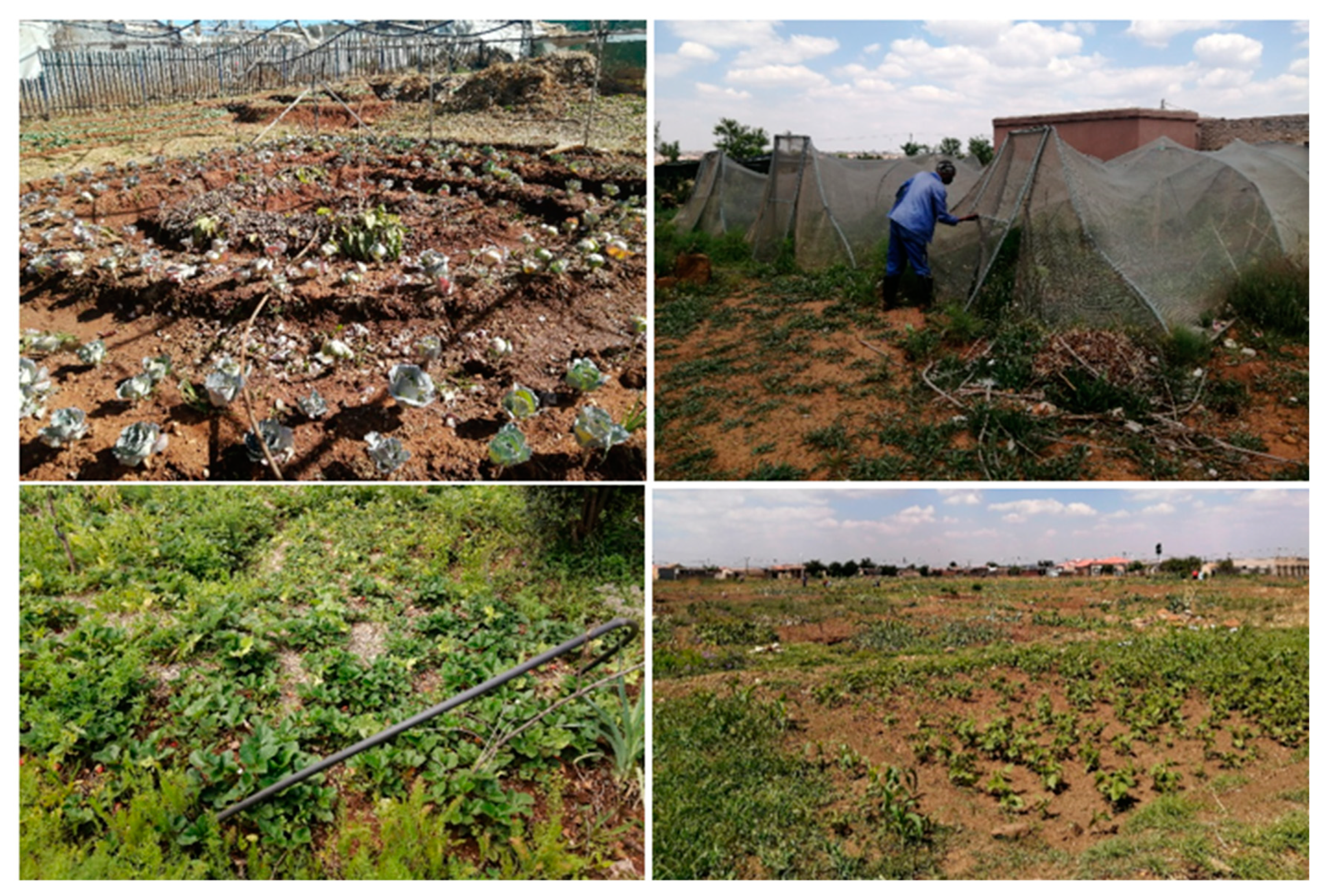
5. Reflections and Implications of Findings

The study has several contributions to new knowledge generation, for policy formulation, academic purposes, and planning for marginalised areas. The methodological approach utilised in this study provides a community-based GIS-MCDMA technique for spatial planning. The criteria adopted can also be upscaled to inform strategies on land development and assessment of the land potential for other economic growth opinions. As such the methodology is a technical tool that serves as an enabler to address spatial challenges in townships, while ensuring that the value of land is maximised, particularly in marginalised areas. The study has proposed the use of PSS to unlock suitable land for urban agriculture within a marginalised area. The study through the cross-validation assessment identified that GOF is experiencing increased land and soil degradation and desertification, with the most severely affected areas being those that are within proximity to the ridge and wetlands. This could have negative consequences on the sustainability of biodiversity in GOF.
The approach informs strategies for developmental anchors in marginalised areas. The development trajectory of marginalised areas such as GOF must hinge on unlocking the potential within them rather than relying on the attraction of economic activity to the area. The potential of the community in the area and of its natural environment need to be unlocked. This human empowerment and enhanced productivity of the environment is the key to livelihood and to migration out of poverty for the residents. Facilitating provision of a productive sustainable environment through investment in emerging economies that are informed by community-based initiatives. A close reflection on urban agriculture in communities such as GOF reveals that urban agriculture enables skills transfer from the elderly to the youth. Moreover, continued investment in such emerging economies has the potential to build on efforts to modernise the township economy.
Lastly, this study brought several findings to attention. Firstly, to ensure sustainable development, the community should be part of the planning process. Secondly, behaviour changes should be supported through community-led programs that address infrastructure and skills development. Thirdly, for government-led initiatives that seek to mitigate risk factors associated with development planning, PSSs have the merit of utilizing socio-economic and environmental datasets. Lastly, the approach builds on efforts to the township economy through the use of GIS-based systems to inform the spatial growth of the township economy.

6. Conclusions

Within the Southern African context, there have been few modelling studies conducted to support policy on strategic land identification. For marginalized areas such as GOF, it is imperative to support emerging economies while also ensuring the preservation of the natural ecosystem. The study utilized a PSS tool to identify strategically located land for urban agricultural activities. The attention and interest in sustainable development in marginalised areas reveals urban agriculture as one emerging economy that has the potential to improve the quality of life of communities in marginalized areas.
Global implications emerging from this study are that there is existential inseparable connection between IKSs and contemporary sustainability planning, which is critical for spatial planning. The benefit of using a GIS-based approach is that it enables planners, urban farmers, and policy makers to collaborate in the development of an index to identify strategic urban agricultural space, especially where communities lack sufficient agricultural space.
Given the analysis presented in this study, it is apparent that all the land parcels within highly suitable and moderately suitable areas should be supported with urban agricultural infrastructure. Areas identified as marginally suitable and suitable sites are capable of contributing to the overall urban agricultural activities in GOF but would require more investment for the fully potential of the land to be realized. The limitations of this study is that the PSS utilised is currently not available online to allow multiple users to interact with the platform. Future research should explore the integration of the PSS to become a Web-based platform, as this would increase the collaborative planning process of the PSS.

Author Contributions

Conceptualization, D.S.N. and T.M.; methodology, D.S.N. and T.M.; software, I.M.; validation, D.S.N., T.M. and I.M.; formal analysis, D.S.N.; investigation, D.S.N.; resources, I.M.; data curation, T.M.; writing—original draft preparation, D.S.N. and T.M.; writing—review and editing, T.M. and I.M.; visualization, D.S.N.; supervision, T.M.; project administration, T.M.; funding acquisition, I.M. All authors have read and agreed to the published version of the manuscript.

Funding

This work is supported by the Centre of Applied Research and Innovation in the Built Environment (CARINBE).

Institutional Review Board Statement

The study was conducted according to the guidelines of the University of Johannesburg’s Research Ethics Committee.

Informed Consent Statement

Informed consent was obtained from all subjects involved in the study.

Data Availability Statement

All the supporting data are available in the manuscript.

Acknowledgments

The authors acknowledge the co-operation and data availed by the Johannesburg Metropolitan City Municipality.

Conflicts of Interest

The authors declare no conflict of interest.

References

  1. Musakwa, W. Identifying land suitable for agricultural land reform using GIS-MCDA in South Africa. Environ. Dev. Sustain. 2018, 20, 2281–2299. [Google Scholar] [CrossRef]
  2. Samiappan, S.; Shamaskin, A.; Liu, J.; Liang, Y.; Roberts, J.; Sesser, A.; Westlake, S.M.; Linhoss, A.; Evans, K.O.; Tirpak, J. Evidence-based land conservation framework using multi-criteria acceptability analysis: A geospatial tool for strategic land conservation in the Gulf coast of the United States. Environ. Model. Softw. 2022, 156, 105493. [Google Scholar] [CrossRef]
  3. Rittenbruch, M.; Foth, M.; Mitchell, P.; Chitrakar, R.; Christensen, B.; Pettit, C. Co-Designing Planning Support Systems in Urban Science: The Questions They Answer and the Questions They Raise. J. Urban Technol. 2022, 29, 7–32. [Google Scholar] [CrossRef]
  4. Keenan, P.B.; Jankowski, P. Spatial decision support systems: Three decades on. Decis. Support Syst. 2019, 116, 64–76. [Google Scholar] [CrossRef]
  5. Mokoena, B.T.; Musakwa, W.; Moyo, T. Developing the Well-Located Land Index to Establish Smart Human Settlements for the Ekurhuleni Municipality, South Africa. In International Conference on Computers in Urban Planning and Urban Management; Springer: Berlin/Heidelberg, Germany, 2017; pp. 95–112. [Google Scholar]
  6. Kukar, M.; Vračar, P.; Košir, D.; Pevec, D.; Bosnić, Z. AgroDSS: A decision support system for agriculture and farming. Comput. Electron. Agric. 2019, 161, 260–271. [Google Scholar]
  7. Flacke, J.; Shrestha, R.; Aguilar, R. Strengthening participation using interactive planning support systems: A systematic review. ISPRS Int. J. Geo-Inf. 2020, 9, 49. [Google Scholar] [CrossRef] [Green Version]
  8. Musakwa, W.; Moyo, T. Perspectives on planning support systems and e-planning in southern Africa: Opportunities, challenges and the road ahead. In Handbook of Planning Support Science; Edward Elgar Publishing: Cheltenham, UK, 2020. [Google Scholar]
  9. Mokoena, B.T.; Sebola, J.P. A multi criteria decision urban development framework for land expropriation in south africa: A strategic approach. Int. Arch. Photogramm. Remote Sens. Spat. Inf. Sci. 2020, 43, 399–407. [Google Scholar] [CrossRef]
  10. Krause, P.; Zuidgeest, M.; Behrens, R. A GIS-based planning support system for inclusionary housing profitability optimization in Cape Town, South Africa. In Handbook of Planning Support Science; Edward Elgar Publishing: Cheltenham, UK, 2020. [Google Scholar]
  11. Janssen, R. Using geodesign for collaborative planning: Development planning in the Lower Zambezi Valley. In Handbook of Planning Support Science; Edward Elgar Publishing: Cheltenham, UK, 2020. [Google Scholar]
  12. Nino, E.C.; Lane, S.; Okano, K.; Rahman, I.; Peng, B.; Benn, H.; Fatti, C.C.; Maree, G.; Khanyile, S.; Washbourne, C. Urban Agriculture in the Gauteng City-Region’s Green Infrastructure Network; Gauteng City Region Observatory (GCRO): Johannesburg, South Africa, 2020. [Google Scholar]
  13. Washbourne, C. Environmental policy narratives and urban green infrastructure: Reflections from five major cities in South Africa and the UK. Environ. Sci. Policy 2022, 129, 96–106. [Google Scholar] [CrossRef]
  14. Malapane, O.L.; Musakwa, W.; Chanza, N.; Radinger-Peer, V. Bibliometric Analysis and Systematic Review of Indigenous Knowledge from a Comparative African Perspective: 1990–2020. Land 2022, 11, 1167. [Google Scholar] [CrossRef]
  15. Stiglitz, J.E. The proper role of government in the market economy: The case of the post-COVID recovery. J. Gov. Econ. 2021, 1, 100004. [Google Scholar] [CrossRef]
  16. Taherzadeh, O. Promise of a green economic recovery post-Covid: Trojan horse or turning point? Glob. Sustain. 2021, 4. [Google Scholar] [CrossRef]
  17. Ng, M.K. Sustainable development goals (SDGs) and pandemic planning. Plan. Theory Pract. 2020, 21, 507–512. [Google Scholar] [CrossRef]
  18. Mensah, J. Sustainable development: Meaning, history, principles, pillars, and implications for human action: Literature review. Cogent Soc. Sci. 2019, 5, 1653531. [Google Scholar] [CrossRef]
  19. Manda, M.I.; Ben Dhaou, S. Responding to the challenges and opportunities in the 4th Industrial revolution in developing countries. In Proceedings of the 12th International Conference on Theory and Practice of Electronic Governance, Melbourne, Australia, 3–5 April 2019; pp. 244–253. [Google Scholar]
  20. Francis, D.; Webster, E. Poverty and inequality in South Africa: Critical reflections. Dev. South. Afr. 2019, 36, 788–802. [Google Scholar] [CrossRef]
  21. Harrison, P.; Todes, A. Strategic Planning and the Challenges of Spatial Transformation in Johannesburg. In The Routledge Handbook of Planning Megacities in the Global South; Routledge: London, UK, 2020; pp. 79–90. [Google Scholar]
  22. Hofer, E.; Musakwa, W.; van Lanen, S.; Gumbo, T.; Netsch, S.; Gugerell, K. Inclusivity insights: Two urban development projects in Johannesburg. J. Hous. Built Environ. 2021, 1–24. [Google Scholar] [CrossRef]
  23. Patel, S. Compact Cities and Land Reform; The Case of South African Cities. In Urban and Transit Planning; Springer: Berlin/Heidelberg, Germany, 2022; pp. 309–319. [Google Scholar]
  24. Martínez, Y.C.; Baños, M.R.; Monroy, H.C. Ecotourism as a path to sustainable development in an isolated Magic Town: The case study of La Trampa, Mexico. J. Tour. Anal. Rev. De Análisis Turístico 2018, 5, 1. [Google Scholar] [CrossRef] [Green Version]
  25. Rogerson, C.M. The economic development of South Africa’s townships. In The Geography of South Africa; Springer: Berlin/Heidelberg, Germany, 2019; pp. 187–194. [Google Scholar]
  26. Scheba, A.; Turok, I.N. Strengthening township economies in South Africa: The case for better regulation and policy innovation. Urban Forum 2020, 31, 77–94. [Google Scholar] [CrossRef]
  27. Mudau, J.; Mahlatsi, M.L.S. Present Realities of Urban Food Insecurity in South African Townships. Afr. Renaiss. 2022, 19, 159–177. [Google Scholar]
  28. Nicola, M.; Alsafi, Z.; Sohrabi, C.; Kerwan, A.; Al-Jabir, A.; Iosifidis, C.; Agha, M.; Agha, R. The socio-economic implications of the coronavirus pandemic (COVID-19): A review. Int. J. Surg. 2020, 78, 185–193. [Google Scholar] [CrossRef]
  29. Jones, K. The City in the Landscape: Alfred Caldwell’s Vision and Experiment for an Ecological City. In Re-Imagining Resilient Productive Landscapes; Springer: Berlin/Heidelberg, Germany, 2022; pp. 223–246. [Google Scholar]
  30. Zeunert, J.; Freestone, R. From Rural Lands to Agribusiness Precincts: Agriculture in Metropolitan Sydney 1948–2018. In Re-Imagining Resilient Productive Landscapes; Springer: Berlin/Heidelberg, Germany, 2022; pp. 247–272. [Google Scholar]
  31. Bouroche, M.; Dusparic, I. Urban computing: The technological framework for smart cities. In Handbook of Smart Cities; Springer: Berlin/Heidelberg, Germany, 2020; pp. 1–25. [Google Scholar]
  32. Mao, D.; Luo, L.; Wang, Z.; Wilson, M.C.; Zeng, Y.; Wu, B.; Wu, J. Conversions between natural wetlands and farmland in China: A multiscale geospatial analysis. Sci. Total Environ. 2018, 634, 550–560. [Google Scholar] [CrossRef]
  33. Clinton, N.; Stuhlmacher, M.; Miles, A.; Uludere Aragon, N.; Wagner, M.; Georgescu, M.; Herwig, C.; Gong, P. A global geospatial ecosystem services estimate of urban agriculture. Earth’s Future 2018, 6, 40–60. [Google Scholar] [CrossRef]
  34. Son, H.N.; Chi, D.T.L.; Kingsbury, A. Indigenous knowledge and climate change adaptation of ethnic minorities in the mountainous regions of Vietnam: A case study of the Yao people in Bac Kan Province. Agric. Syst. 2019, 176, 102683. [Google Scholar] [CrossRef]
  35. Makondo, C.C.; Thomas, D.S. Climate change adaptation: Linking indigenous knowledge with western science for effective adaptation. Environ. Sci. Policy 2018, 88, 83–91. [Google Scholar] [CrossRef]
  36. Siegner, A.; Sowerwine, J.; Acey, C. Does urban agriculture improve food security? Examining the nexus of food access and distribution of urban produced foods in the United States: A systematic review. Sustainability 2018, 10, 2988. [Google Scholar] [CrossRef] [Green Version]
  37. Kuyu, C.G.; Bereka, T.Y. Review on contribution of indigenous food preparation and preservation techniques to attainment of food security in Ethiopian. Food Sci. Nutr. 2020, 8, 3–15. [Google Scholar] [CrossRef] [PubMed]
  38. Te Brömmelstroet, M. Performance of planning support systems: What is it, and how do we report on it? Comput. Environ. Urban Syst. 2013, 41, 299–308. [Google Scholar] [CrossRef]
  39. Boulange, C.; Pettit, C.; Gunn, L.D.; Giles-Corti, B.; Badland, H. Improving planning analysis and decision making: The development and application of a Walkability Planning Support System. J. Transp. Geogr. 2018, 69, 129–137. [Google Scholar] [CrossRef]
  40. Trenerry, B.; Chng, S.; Wang, Y.; Suhaila, Z.S.; Lim, S.S.; Lu, H.Y.; Oh, P.H. Preparing workplaces for digital transformation: An integrative review and framework of multi-level factors. Front. Psychol. 2021, 12, 620766. [Google Scholar] [CrossRef]
  41. Onososen, A.O.; Musonda, I. Perceived Benefits of Automation and Artificial Intelligence in the AEC Sector: An Interpretive Structural Modeling Approach. Front. Built Environ. 2022, 8, 864814. [Google Scholar] [CrossRef]
  42. Quan, S.J.; Minter, J.D.; Yang, P.P. A GIS-based performance metrics for designing a low energy urban agriculture system. In Planning Support Systems for Sustainable Urban Development; Springer: Berlin/Heidelberg, Germany, 2013; pp. 225–247. [Google Scholar]
  43. Deal, B.; Pallathucheril, V.; Heavisides, T. Ecosystem Services, Green Infrastructure and the Role of Planning Support Systems, Planning Support Systems for Sustainable Urban Development; Springer: Berlin/Heidelberg, Germany, 2013; pp. 187–207. [Google Scholar]
  44. Pettit, C.; Bakelmun, A.; Lieske, S.N.; Glackin, S.; Thomson, G.; Shearer, H.; Dia, H.; Newman, P. Planning support systems for smart cities. City Cult. Soc. 2018, 12, 13–24. [Google Scholar] [CrossRef]
  45. Coetzee, M.; Waldeck, L.; Le Roux, A.; Van Niekerk, W.; Meiklejohn, C.; Leuta, T. Spatial policy, planning and infrastructure investment: Lessons from urban simulations in three South African cities. Stads-En Streeksbeplanning Town Reg. Plan. 2014, 2014, 1–9. [Google Scholar]
  46. Van Huyssteen, E.; Biermann, S.; Naudé, A.; Le Roux, A. Advances in spatial analysis to support a more nuanced reading of the South African space economy. Urban Forum 2009, 20, 195–214. [Google Scholar] [CrossRef]
  47. Van Huyssteen, E.; Mans, G.; Le Roux, A.; Maritz, J.; Ngidi, M.; Maditse, K. Profiling SA System of Towns-Introducing the CSIR/SACN South African Settlement Typology. Pretoria: CSIR 2016. Available online: http://stepsa.org/pdf/projects/201508_South%20African%20Settlement%20Typology_Category%20descriptions.pdf (accessed on 19 June 2022).
  48. Waddell, P.; Whitcomb, C.; Figari, F.; Fernandez, F.; Martinez, J. Penciler: A web-based affordable housing development feasibility analysis tool. In Handbook of Planning Support Science; Edward Elgar Publishing: Cheltenham, UK, 2020. [Google Scholar]
  49. Franco, I.B.; Tracey, J. Community capacity-building for sustainable development: Effectively striving towards achieving local community sustainability targets. Int. J. Sustain. High. Educ. 2019, 20, 691–725. [Google Scholar] [CrossRef]
  50. Hopfe, C.J.; McLeod, R.S. Enhancing resilient community decision-making using building performance simulation. Build. Environ. 2021, 188, 107398. [Google Scholar] [CrossRef]
  51. Khaira, A.; Dwivedi, R.K. A state of the art review of analytical hierarchy process. Mater. Today Proc. 2018, 5, 4029–4035. [Google Scholar] [CrossRef]
  52. Leal, J.E. AHP-express: A simplified version of the analytical hierarchy process method. MethodsX 2020, 7, 100748. [Google Scholar] [CrossRef] [PubMed]
  53. Willkomm, M.; Follmann, A.; Dannenberg, P. Rule-based, hierarchical land use and land cover classification of urban and peri-urban agriculture in data-poor regions with RapidEye satellite imagery: A case study of Nakuru, Kenya. J. Appl. Remote Sens. 2019, 13, 016517. [Google Scholar] [CrossRef]
  54. Dhiman, V. Organic farming for sustainable environment: Review of existed policies and suggestions for improvement. Int. J. Res. Rev. 2020, 7, 22–31. [Google Scholar]
  55. Karimi, H.; Amiri, S.; Huang, J.; Karimi, A. Integrating GIS and multi-criteria decision analysis for landfill site selection, case study: Javanrood County in Iran. Int. J. Environ. Sci. Technol. 2019, 16, 7305–7318. [Google Scholar] [CrossRef]
  56. Houdet, J.R. Transitioning to a Green Economy in the Gauteng City Region: Assessing Local Municipalities’ Readiness. Available online: https://www.researchgate.net/publication/293482451_Transitioning_to_a_Green_Economy_in_the_Gauteng_City_Region_Assessing_Local_Municipalities_readiness (accessed on 12 May 2022).
  57. Ferreira, A.J.D.; Guilherme, R.I.M.M.; Ferreira, C.S.S. Urban agriculture, a tool towards more resilient urban communities? Curr. Opin. Environ. Sci. Health 2018, 5, 93–97. [Google Scholar] [CrossRef]
  58. Maziriri, E.T.; Mapuranga, M.; Tafadzwa, C.M.; Nzewi, O.I. Navigating on the key drivers for a transition to a green economy: Evidence from women entrepreneurs in South Africa. Entrep. Sustain. Issues 2019, 7, 1686. [Google Scholar] [CrossRef]
  59. Batrancea, L.; Pop, M.C.; Rathnaswamy, M.M.; Batrancea, I.; Rus, M. An empirical investigation on the transition process toward a green economy. Sustainability 2021, 13, 13151. [Google Scholar] [CrossRef]
  60. Lucke, S.; Mamo, E.; Koenigstorfer, J. Exploring the meaning of growing food in community gardens to South African township residents: A photovoice study. Health Place 2019, 55, 165–176. [Google Scholar] [CrossRef] [PubMed]
  61. Petersen, L.M.; Charman, A. The scope and scale of the informal food economy of South African urban residential townships: Results of a small-area micro-enterprise census. Dev. S. Afr. 2018, 35, 1–23. [Google Scholar] [CrossRef]
Figure 1. Location of Study Area.
Land 11 01713 g001
Figure 2. Strategic land index for GOF.
Land 11 01713 g002
Figure 3. Location of cross-validation sites for highly suitable and moderately suitable.
Land 11 01713 g003
Figure 4. Existing urban agricultural activities in marginally suitable and suitable areas.
Land 11 01713 g004
Figure 5. Strategic land for urban agriculture in GOF.
Land 11 01713 g005
Table 1. List of PSSs in Southern Africa.
Name of PSSSystemApproachSource
Well-Located Land IndexCollaboration in GISEnables users to unlock strategic land[5]
UrbanSIMUrban simulation systemEnables users to explore, gain insights into, and develop and evaluate alternative plans to improve their communities[45]
Geospatial Analysis Platform (GAP)Web-based profiling platformEnables users to explore a common strategic basis for profiling people and their associated activities[46]
Regional Spatial ProfilerWeb-based profiling platformEnables users to explore regional-scale spatial planning information to support planners and decision makers[47]
PencilerWeb-based affordable housing development feasibility analysis toolEnables users to explore housing data using constrained optimization to layout residential floorplans given the zoning constraints of the site and building programme requirements of the user[48]
GIS inclusionary housing optimisationOffline profiling platformEnables users to rank inclusionary housing profitability optimisation[10]
Geodesign toolGeodesign for collaborative planningEnables users to present and interact spatial data sets through a graphic interface[11]
Table 2. Profile of workshop participants.
ProfessionNumberExperience
Urban Designers28–15 years
Urban Planners310–20 years
GIS professionals28 years
GOF Urban Agriculture Forum222 to 15 years
GOF SMMEs Forum161 to 6 years
Table 3. Criteria to identify strategic land in GOF.
CriteriaWeightRank
Land cover151
NDVI (vegetation)13.62
Soil Texture11.53
Agriculture Potential9.64
Proximity to rivers (water source)8.45
Average annual rainfall7.66
Elevation (Slope)7.27
Environment Sensitive Areas6.48
Groundwater quality6.29
Strategic infrastructure projects5.410
Proximity to Informal settlement3.411
Proximity to Public Transportation Facilities312
Annual temperature (minimum)1.413
Annual temperature (maximum)1.314
Table 4. Mapping and criteria rule sets.
IndexInterpretation
Highly SuitableLand without significant limitations.
Moderately SuitableThe Land can be utilised to a certain extent for farming but would require some investment to ensure sustainability
Marginally SuitableThe Land can be utilised for small-scale farming; however, it would require significant infrastructure support to upscale economic benefits
Least suitableThe land has several limitations which would need to be addressed before it can be utilised for farming.
Not SuitableThe Land is not suitable for farming; this is because the proposed activity will negatively impact the land or the land is reserved for another purpose
Table 5. Ruleset for strategically located land.
Criteria Highly   Suitable - a i Moderately   Suitable - b i Marginally   Suitable - c i Suitable - d i Not   Suitable - e i Source
Land coverNaturalCultivated; PlantationsBuilt upDegradedWetland, water bodies[12,53]
NDVI (vegetation)>0.750.5–0.750.3–0.490.25–0.3<0.25[1,54]
Soil TextureSandy and well-drained soilsClay soilsSilty or silty clayChalky soilPeat or muck[53]
Agriculture PotentialAgricultural Catalytic projectsIdentified for Future Agricultural investment (to be implemented within 5–10 years) Identified for Future Agricultural investment (to be implemented within 10–20 years)Identified for Future developmentEnvironmentally sensitive area[6,54]
Proximity to rivers (water source)<1 km1–2 km2–4 km4.1–6 km>6 km[46,55]
Elevation (Slope)1200–2000 m200–400 m401–1200 m 2001–2500 mSea level, <200 m or N2500 m [13,54]
Strategic infrastructure projects<5 km5–10 km10–15 km15–20 km>20 km[16,56]
Environment Sensitive AreasAreas without wetland or ridgeN/AN/AN/AAreas with wetland or ridge[13,14]
Proximity to Informal settlement<1 km1–3 km3.1–4 km4.1–6 km>6 km[13,26,45]
Proximity to Public Transportation Facilities<1 km1–2 km2.1–3 km3.1–4 km>4 km[9,53]
Average annual rainfall600–800 mm200–400 mm400 m–600 mm800–1000 mm<0–200 or >2500 mm[2,9]
Annual temperature (minimum)<84–82–40–2−1.9–0 or <−2[1,12]
Annual temperature (maximum)0–23 or 23.1–2323.1–2727.1–3030.1–35>35[1,12]
Ground water quality<7070–300301–600601–1000>1000[5,57]
Publisher’s Note: MDPI stays neutral with regard to jurisdictional claims in published maps and institutional affiliations.

