1. Introduction
With the continuous development of the economy and society, the role of tourism in promoting the growth of the national economy has become increasingly vital, as tourism is a catalyst that promotes the transformation of industrial structures and the development of rural agriculture [
1]. The World Tourism Organization regards tourism as an important means of achieving the third millennium goal; among the 56 countries that have adopted poverty reduction strategies, 80% of them utilize tourism as an option for economic growth, employment, and poverty reduction [
2]. Rural areas are important spatial carriers for economic development and are also important food supply areas for urban development and hometowns. With the advancement of urbanization and industrialization, urban problems such as traffic congestion and serious pollution continue to emerge and impose tremendous psychological and physical pressure on urban residents [
3,
4]; moreover, the risk of disease is also increasing [
5,
6]. Rural tourism is gradually sought after by urban residents because of its orientation toward natural pastoral scenery and its ability to eliminate the negative impacts of urbanization. In addition, the hollowing out of villages, the loss of the labor force, and the deterioration of the rural environment caused by the long-term disadvantages of rural areas during the process of urbanization have been considered by various governments. The development of rural tourism is of great significance for balancing the economic gap between urban and rural areas and solving rural problems. Rural tourism is not only regarded as an important means by which to solve rural problems; it can also promote economic growth [
7] and can use local natural and human resources to promote handicraft production in the agricultural sector, improve the local living environment conditions, and protect cultural heritage and folk customs [
8]. In summary, the development of rural tourism will bring positive changes to the regional economy, society, environment, and material conditions.
The development of rural tourism has been relatively successful in many regions and countries, among which Europe and the United States are considered to be the most successful. The European Union has proposed a European tourism management plan for rural tourism, provides rural tourism support in many fields and aspects [
9], and regards rural tourism as an important means of rural economic reconstruction and development [
10]. In response to the unbalanced development of rural tourism, the United States actively promotes its construction and development in weak areas and strengthens the publicity and education of rural tourism in rural communities. The Spanish government takes into account the role of rural tourism associations; actively promotes the flow of information, technology, and other elements; and promotes the sustainable development of rural tourism. Regarding developing countries, the South African government regards rural tourism as the main means of economic development and promotes the living standards of residents in rural tourism communities through activities such as wildlife viewing and gambling [
11]. The Ministry of Culture and Tourism of China actively supports the development of rural tourism and responds to the rural revitalization strategy. The key rural tourism villages (hereinafter referred to as key villages) in mainland China are located in 31 provinces and municipalities and have played an important role in the economic reconstruction of local rural areas, the increase in farmers’ incomes, and poverty alleviation.
As one of the important types of rural tourism destinations, key villages have obvious regional and comprehensive characteristics. In terms of the existing research, although some results on the spatial structures of rural tourism destinations have been obtained [
12,
13], there remain many shortcomings. Previous research conducted at the spatial scale has been mostly concentrated in the administrative divisions of the provincial and municipal levels [
14,
15,
16], which, to a certain extent, disrupt the integrity of natural zones and also cause some interference with the research conclusions. Previous studies conducted on the scale of river basins are relatively few, and the existing research related to China is limited to the Yangtze River Basin [
17]. In contrast, the complexity of the development of China’s Yellow River Basin is due to its unique natural geographical conditions [
18]. Thus, research on rural tourism destinations in the Yellow River Basin would be of great significance for the response to the Chinese government’s ecological protection and high-quality development strategy for the basin and the promotion of poverty reduction in poverty-stricken areas. In addition, regarding the analysis of the natural resource factors affecting the development of rural tourism destinations, the existing research is more biased toward flat, agricultural production areas [
19,
20], and there have been a few studies on mountainous areas with higher slopes and altitudes. Increasingly more scholars have noted that the generation and development mechanisms of geographic phenomena will be very different when considered at different spatial scales [
21,
22]. Therefore, research on ecologically fragile and marginalized regions can provide a clearer understanding of the spatial characteristics of rural tourism in China’s impoverished mountainous areas and the unequal development of the spatial economy. In addition, the conclusions of research on the spatial structure and sustainable development of rural tourism destinations in poor mountainous areas can also be applied to other developing countries and regions to provide effective reference values for spatial reconstruction and sustainable development of rural tourism destinations.
With the continuous development of Internet technology and the wide application of spatial big data, data availability has greatly improved. Consequently, research on the spatial structure of rural tourism destinations has made significant progress. Spatial analysis methods combined with geographic information system (GIS) technology, such as spatial autocorrelation [
23], spatial hot spot clustering [
24], and kernel density estimation [
25], have been widely used in the study of the spatial structure of rural tourism destinations. Although geographic data and related research methods have opened up a new channel for the analysis of the spatial structure of rural tourism destinations, the research on rural tourism destinations in poor mountainous areas at the basin scale remains inadequate, and further follow-up research is urgently needed.
The research questions of this topic are two-fold. First, what is the spatial structure of rural tourism destinations in poor mountainous areas at the watershed scale? What are the factors influencing it under special natural conditions? Second, what are the laws and mechanisms for the sustainable development of rural tourism in these marginalized areas from a spatial perspective? How can the rural transformation from an agricultural village to a tourist village be achieved? In order to achieve this goal, this project takes key villages in the Yellow River Basin as an example to summarize the evolutionary patterns of rural tourism development under complex topographical conditions in China, to fill the gaps in existing research, which is also of reference value for the development of rural tourism in other poor mountainous areas. The study of the above issues will help us to further explore the sustainable development mechanism of rural tourism in poor areas and to actively link tourism development with rural transformation around relevant interest groups such as the government, associations, and local villagers. In addition, we propose sustainable development measures and suggestions from different perspectives based on the sustainable development mechanism of rural tourism, taking into account the characteristics of the evolution of rural industries and social structures in the key villages. This is of great significance to the Chinese government in proposing a rural revitalization strategy as well as the construction of new rural areas.
The remainder of this article is organized as follows.
Section 2 provides the literature review and reviews the results of previous studies.
Section 3 introduces the research methods and data sources used in the present study.
Section 4 presents the main content of this article, which includes a spatial structure analysis of rural tourism destinations, research on the influencing factors, and a discussion on the mechanism of the sustainable development of rural tourism destinations. Finally,
Section 5 presents conclusions and discussions, and puts forward suggestions for the sustainable development of rural tourism.
3. Research Methods and Data Sources
3.1. Research Area
The Yellow River Basin spans across China’s three comprehensive natural belts, and covers nine provinces and autonomous regions of Qinghai, Gansu, Ningxia, Inner Mongolia, Shaanxi, Shanxi, Henan, Shandong, and Sichuan. As only Aba Prefecture and Ganzi Prefecture in Sichuan Province are within the scope of the basin defined in this article, and because no key villages have been announced in these prefectures, the former eight provinces were the main provinces considered in this study at the time of data processing. The overall economic development of the provinces in the basin is relatively low, especially in the upper and middle reaches of Qinghai, Gansu, and other provinces where there is a high level of poverty. Among the 14 areas characterized by deep poverty announced by the Ministry of Agriculture and Rural Affairs of China, the Yellow River Basin occupies five. As of the time at which this research was conducted, two batches of a total of 127 key villages in the nine provinces composing the Yellow River Basin had been announced.
3.2. Research Method
This paper proposes a spatial technology method based on mathematical models, analyzes the spatial structure of rural tourism destinations, and effectively identifies the change trends and spatial patterns of key villages in the Yellow River Basin. The methods used in this research mainly include the nearest neighbor index, disequilibrium index, global spatial autocorrelation, the local correlation index (Getis-Ord Gi*), and the geographic connection rate. These methods can be used to effectively analyze the spatial type, equilibrium degree, agglomeration level, cluster distribution, and concentration degree of rural tourism destinations. These methods are independent of each other and have been widely used in the study of the spatial structure of rural tourism destinations to reflect the combination of elements and spatial characteristics of key villages. ArcGIS (Esri, Redlands, CA, USA), Geoda (Developed by Dr Luc Anselin and his team, Chicago, IL, USA), and other software were used in this study to achieve a visual display of the data.
3.2.1. Nearest Neighbor Index
The nearest neighbor index can well reflect the spatial distribution characteristics of point-like elements. The calculation method is the ratio of the actual nearest distance to the theoretical nearest distance (i.e., the theoretical value when randomly distributed). The nearest neighbor index can indicate the degree of mutual proximity of key villages in the Yellow River Basin in geographic space and determine their spatial distribution types [
59]. ArcGIS software spatial statistics tools were used for analysis to more accurately detect the distribution patterns of key villages. The calculation formulas are as follows:
where
R is the nearest neighbor index,
n represents the number of key villages in the Yellow River Basin,
A is the area of the study area. When
R = 1, the point represents the feature of a random distribution; when
R > 1, the point represents the feature of a uniform distribution; when
R < 1, the point represents the feature of an agglomeration distribution.
3.2.2. Disequilibrium Index
The disequilibrium index is an indicator reflecting the distribution of key villages within each province, the value range of which is 0 to 1; the larger the index value, the more uneven the distribution. In addition, this article introduces the Lorenz curve to further reflect the imbalance of key villages. The Lorenz curve, introduced by Lorenz in 1905, expresses the cumulative proportion of a variable and ranks it from low to high [
60]. The calculation formula is as follows:
where
G is the disequilibrium index;
n is the number of provinces and regions; and
Yi is the number of key villages in each province, and is sorted from largest to smallest.
3.2.3. Kernel Density Estimation
Kernel density estimation is a non-parametric test method used in probability theory to estimate the unknown density functions. It uses smooth peak functions to fit the observed data points to simulate the true probability distribution curve. Kernel density estimation has been widely used in measurements of building density and in obtaining crime reports. This method does not rely on pre-supposed distributions but only on the data themselves to study the distribution characteristics of events. Kernel density estimation can directly reflect the spatial dispersion or agglomeration characteristics of geographic elements. Thus, kernel density estimation was used in the present work to reflect the degree of agglomeration of key villages.
where
is the kernel function,
h > 0 is the broadband,
represents the distance to the estimated value. For
, the larger the value, the denser the point distribution.
3.2.4. Spatial Autocorrelation Analysis
The Global Moran Index was proposed by the Australian statistician Patrick Alfred Pierce Moran and is an important indicator used to measure spatial correlation. The significance of this index can be evaluated by calculating the Moran’s
I index value,
z-score, and
p-value. For example, the Global Moran Index can be used to analyze the relationship between the crime rate in a certain area and the location of the area, and to judge the spatial correlation of crime incidents. The Global Moran Index can also be used to judge whether the spatial distribution of elements in a region reflects a clustering, discrete, or random mode [
61]. Its calculation formula is as follows:
where
xi,
xj represent the number of key rural tourism villages in regions
i and
j,
wij is a space vector matrix,
x represents the average value,
n represents the total number of samples. Moran’s value range is [−1, 1]. The larger the value, the stronger the correlation of the spatial distribution of the elements.
Local correlation index
, also known as cold and hot spot analysis, is used to explain the spatial autocorrelation of regional factors and measure the hot and cold spots. Via the obtained
z-score and
p-value, the spatial locations of clustered high- and low-value elements can be known, and this method has been widely used in research in many fields [
62]. In the present study, ArcGIS software was used to identify the spatial hot spots and cold spots of key villages, and the calculation formula is as follows:
where
xi,
xj represent, respectively, the numbers of key villages in area
i and
j,
represents the spatial weight function. If the result of
G(d) is positive and significant, it indicates that the value around
i is higher than the average value, and reflects high-value spatial agglomeration; if the result of
G(d) is negative and significant, it indicates that the value around
i is lower than the average value, and reflects low-value spatial agglomeration [
63].
3.2.5. Geographic Contact Rate
The geographic connection rate is used to analyze the degree of association between a certain element and other elements in a region and was used in this study to analyze the relationships between the key villages in the Yellow River Basin and the regional tourism economy and GDP. The calculation formula is as follows:
where
L is the geographic connection rate,
Xi is the proportion of key villages in region
i (%), and
Yi is the proportion of tourism income and GDP in region
i (%).
3.3. Data Sources
Research was conducted on two batches of data on key villages published on the website of the Ministry of Culture and Tourism of the People’s Republic of China (
https://www.mct.gov.cn (accessed on 22 May 2021)). As of the study date, there were a total of 127 key villages in the Yellow River Basin. The Baidu Map (Baidu, Beijing, China) application programming interface (API) coordinate selection system (
api.map.baidu.com/lbsapi/get/point/index.html (accessed on 22 May 2021)) was used to obtain the latitude and longitude coordinates of the 127 key villages in the Yellow River Basin, after which ArcGIS 10.2 software was used to visualize the specific locations of the key villages on the map. Basic geographic data (e.g., administrative divisions, transportation, government locations, etc.) were mainly sourced from the website of the China National Basic Geographic Information Center (
www.ngcc.cn/ngcc/ (accessed on 22 May 2021)). The data of China’s digital elevation model (DEM) with a resolution of 90 × 90 m were primarily derived from the geospatial data cloud website (
www.gscloud.cn/ (accessed on 22 May 2021)). The relevant data on the GDP, population, and regional economy were sourced from the website of the National Bureau of Statistics of China (
www.stats.gov.cn (accessed on 22 May 2021)) and the statistical yearbooks of the relevant eight provinces.
4. Results Analysis
This section presents the main content of this article. First, the spatial structure characteristics of rural tourism destinations, mainly including the spatial distribution type, balance, density, and correlation characteristics, were analyzed. On this basis, the factors affecting rural tourism destinations were explored from the dimensions of economic, social, and physical geographical conditions. To further clarify the development of the rural tourism industry, the key villages were classified according to existing standards. Finally, based on previous research conclusions regarding the development of tourism in key villages, the influencing factors, and the development of characteristic industries, a sustainable development transformation mechanism for rural tourism destinations is proposed.
4.1. Spatial Distribution Characteristics
4.1.1. Types of Spatial Distributions
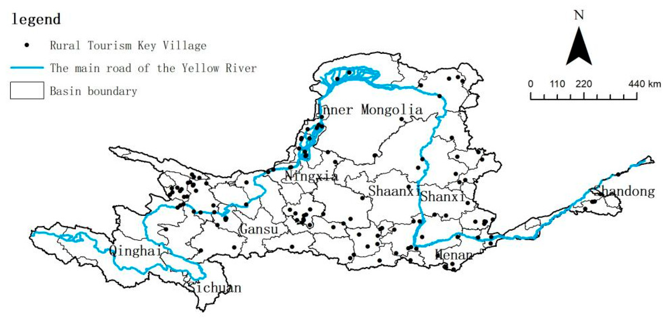
The nearest-neighbor index
R is introduced in this research to clearly explain the spatial distribution types of the key villages in the Yellow River Basin. Via the use of ArcGIS 10.2 software, the average actual closest distance of key villages was calculated as 39.68 km; the theoretical closest distance was calculated as 60.25 km, which is greater than the average actual closest distance; and the nearest-neighbor index was calculated as 0.66. These results demonstrate that the key villages in the Yellow River Basin are characterized by cohesion in terms of their spatial distribution (
Figure 1).
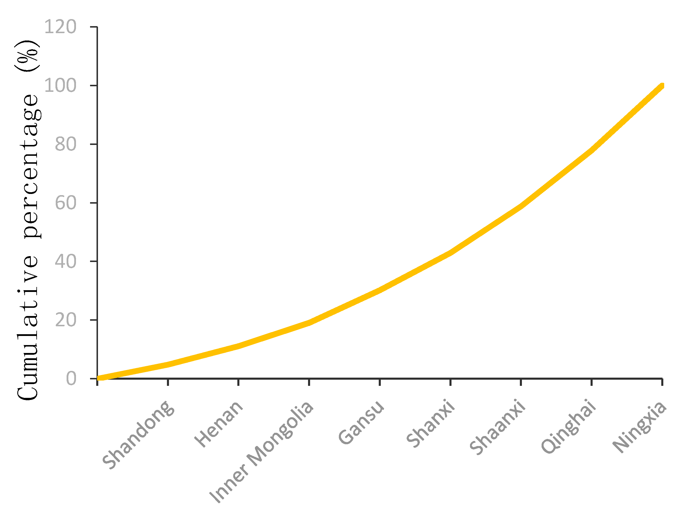
4.1.2. Spatial Distribution Balance
The disequilibrium index was selected to reflect the degree of equilibrium of the spatial distribution of key villages in the Yellow River Basin. According to Equation (3), the disequilibrium index was calculated as
G = 0.307. Furthermore, the Lorenz curve of the key villages in the Yellow River Basin was drawn. From
Figure 2, it is evident that the Lorenz curve exhibits a downward trend, which more clearly reveals the uneven distribution of the key villages.
4.1.3. Spatial Distribution Density
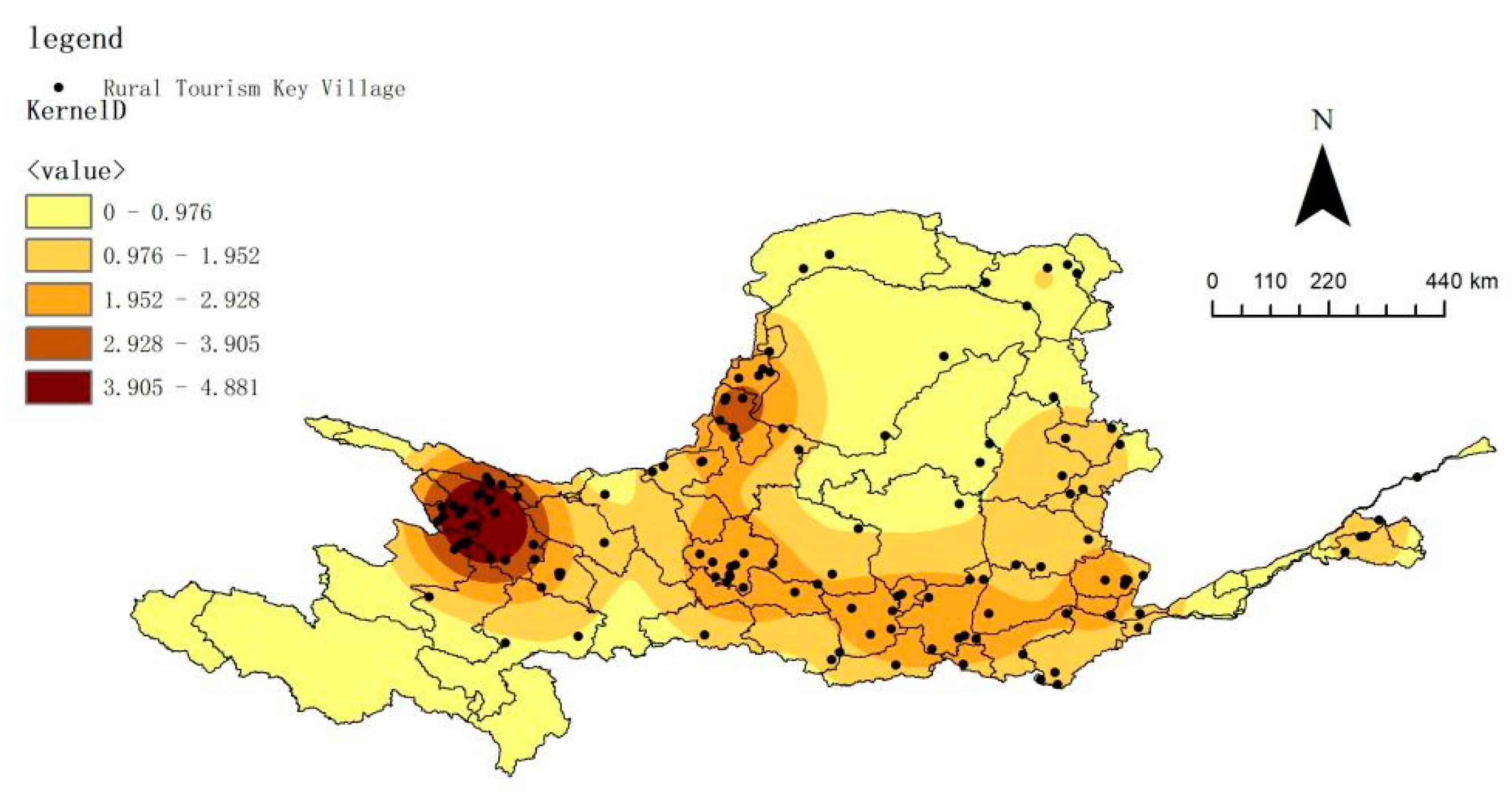
The map of the key villages in the Yellow River Basin was coupled with the base map of the administrative divisions of cities and prefectures, and the density distribution of cities and prefectures in these villages was calculated (
Figure 3). Based on the findings, the high-density areas of the key villages in the Yellow River Basin are mainly distributed in four regions. The first is the junction of Xining and Haidong; the second is the Yinchuan-Shizuishan-Zhongwei longitudinal belt; the third is the surrounding area with Guyuan City as the core; the fourth is the Xi’an-Weinan-Xianyang block area. At the junction of Xining and Haidong, the core density value of the basin is high, ranging from 1.952 to 4.881/km
2. The key villages are the most concentrated in this area and form a single-nucleus concentration area around Xining, which is located in the Hehuang Valley between the north and south mountains. The highest kernel density in the Yinchuan-Shizuishan-Zhongwei longitudinal zone is 3.905/km
2, and the distribution of key villages in this area is uneven and scattered; they form a vertical distribution pattern centered on Yinchuan, through which the Yellow River runs, and are mainly distributed along the plains and hills. The kernel density of the surrounding area of Guyuan City as the core is relatively low, ranging from 1.952 to 2.928/km
2. The distribution of key villages in this area is relatively concentrated, and the central city is significant. The terrain is located in the Jinghe River Valley and along the eastern foot of Liupan Mountain. The core density value of the Xi’an-Weinan-Xianyang area is similar to that of Guyuan. The distribution of key villages in this area is the most scattered and reflects an uneven distribution. The villages are mainly distributed in the Weihe Plain and are divergently distributed along the north side of the Qinling Mountains. In addition, two concentrated areas with higher density values have also formed in the eastern part of the basin. The distribution area is southeast Shanxi with Jincheng as the center and is close to the most developed areas of the Central Plains, which are characterized by urban agglomeration in the basin. The development of rural tourism in this area began early and has formed an industrial agglomeration. Finally, the distribution area with Hohhot as the core was found to have a relatively low core density value; however, due to the geographical advantages of its neighboring cities, rural tourism in this area has great potential for development.
4.1.4. Spatial Distribution Association
The Global Moran Index was used to detect the global correlation of the key villages in the Yellow River Basin. The calculation results reveal that the value of Moran’s
I index is 0.183, the
z-score is 3.388 > 2.58, and the confidence level is 99%, thereby passing the significance test. This demonstrates that the spatial distribution of the key villages in the Yellow River Basin exhibits a certain trend of aggregation. The
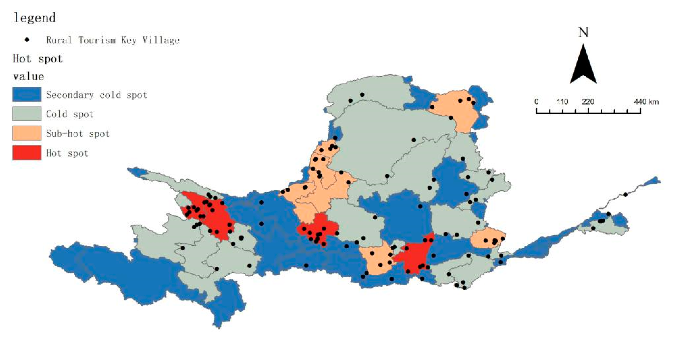
Getis-Ord Gi* values of the correlation index of cities, states, and localities in the Yellow River Basin were further calculated; the resulting values were divided into four categories according to the natural breakpoint method; and the results were visualized. As shown in
Figure 4, there are few hot spots distributed in the surrounding areas centered on regional provincial capitals, which reflect the core area in terms of spatial association. Thus, the geographical and tourist source advantages of these areas close to cities have effectively promoted the development of the surrounding rural tourism. The main areas are Xining and Haidong in Qinghai Province, Guyuan City in Ningxia Hui Autonomous Region, and Weinan City in Shaanxi Province, which together account for 25.9% of the total Yellow River Basin. The sub-hot spots are mainly arranged in the adjacent areas of the hot spots, and their distribution is relatively concentrated. The area with the highest concentration of sub-hot spots is the Ningxia Hui Autonomous Region, which radiates from Yinchuan to the surrounding area; it includes Shizuishan City, Wuzhong City, Yinchuan City, and Zhongwei City in the Ningxia Hui Autonomous Region, Hohhot City in the Inner Mongolia Autonomous Region, Xianyang City in Shaanxi Province, and Jincheng City in Shanxi Province, which together account for 24.4% of the entire Yellow River Basin. The cold spot area is the transitional area in the spatial correlation, and the distribution is also relatively concentrated; the area includes Ordos, Bayannaoer, and Yulin in the Inner Mongolia Autonomous Region, Xinzhou, Taiyuan, Jinzhong, and Linfen in Shanxi Province, and Luoyang in Henan Sanmenxia City, among others. The remaining cities and prefectures are all sub-cold spots, which are mainly distributed in the upper and middle reaches of the basin. These areas reflect the marginal areas in the spatial correlation. Some areas have become isolated points, and these account for 13.4% of the total basin. Overall, the sub-hot spots and cold spots are significant areas for local spatial differentiation of the key villages in the Yellow River Basin, accounting for 60.6% of the total. The distribution area of hot spots and sub-cold spots is relatively small, accounting for 39.4% of the total.
Overall, the key villages in the Yellow River Basin exhibit a spatial distribution pattern of greater concentration in the west and south than in the east and north, respectively, which is highly coupled with the conclusions of this study on the distribution of village density. The area with a high kernel density has the highest coupling value with hot spots and sub-hot spots, and it is relatively concentrated in major cities with relatively developed regional economies [
63]. At present, the key villages in the Yellow River Basin form a distribution pattern with Xining as the core and Yinchuan, Guyuan, Weinan, and Jincheng as strips, thereby exhibiting a “one core and one belt” distribution pattern. Specifically, although the Xining and Haidong regions are remote, they represent gathering areas of ethnic minorities and are rich in tourism resources with ethnic characteristics. Under the influence of the closed terrain, they retain more ethnic folk customs and village styles, and the resource background advantage of developing rural tourism is outstanding in these regions. The ethnic cultural elements of rural tourism development in the surrounding cities centered on Yinchuan are similar to those of Xining and Haidong; in particular, the characteristics of the Hui ethnic minority region are the most significant. In the past, due to its underdeveloped economic level, the rural tourism market in this region had not achieved great development. However, in recent years, with the support of policy and transportation construction, rural tourism has achieved rapid growth. Weinan, Xianyang, Xi’an, and other cities have a solid economic foundation, a vast tourist source market, complete tourism industry elements, and outstanding advantages in rural tourism development and construction and have formed a highly concentrated radiation area centered on Xi’an. The scale of the tourism economy is in an absolutely dominant position in the basin [
64], and its radiating effect on surrounding cities is significant.
4.2. Analysis of Influencing Factors
4.2.1. Historical and Cultural Factors
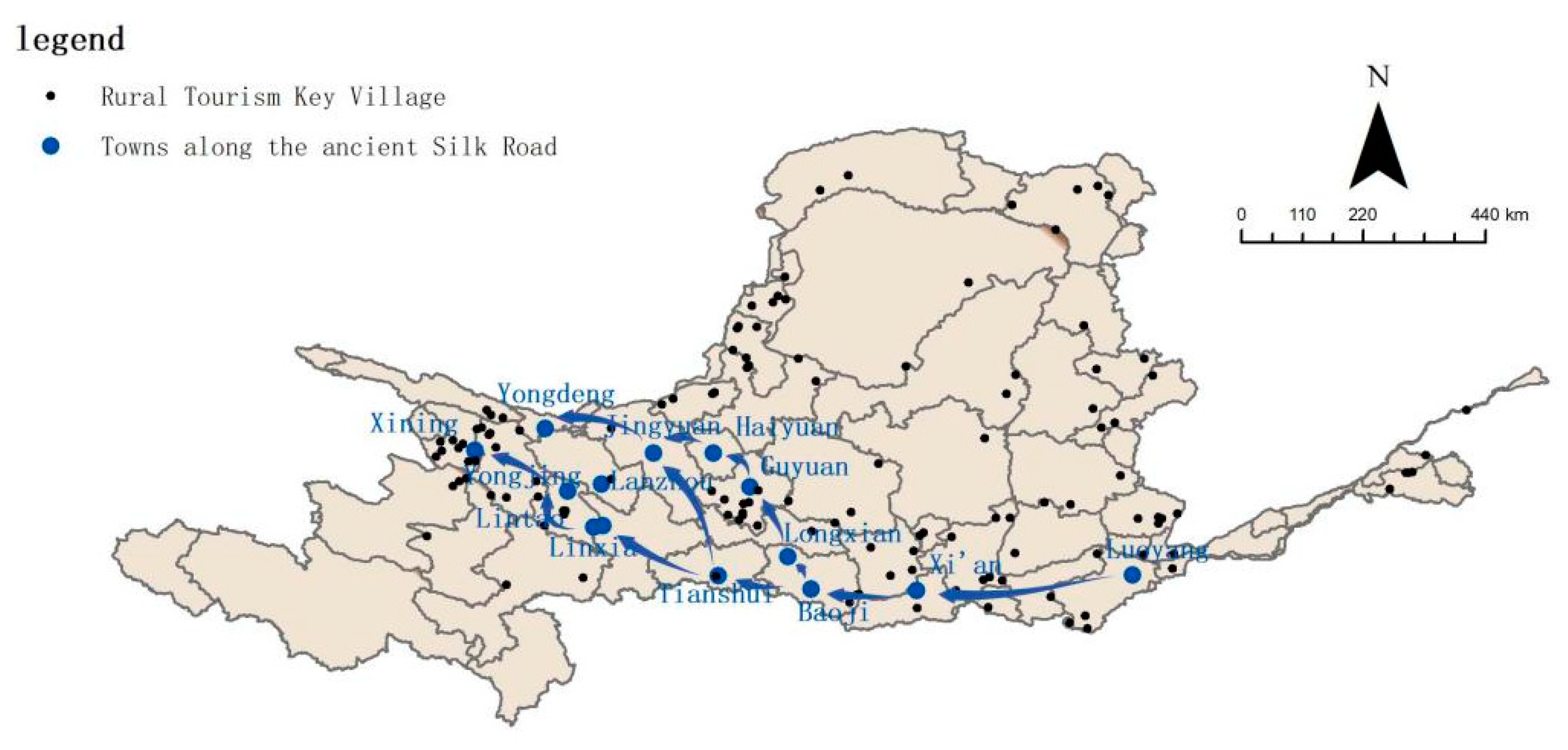
The ancient Silk Road was a land-based trade and cultural exchange channel connecting Eastern and Western civilizations; it started from Luoyang and Chang’an (now Xi’an) in China in the east, traversed Eurasia through the Hexi Corridor in Northwest China, and reached the Mediterranean coast in the west [
65]. The towns along the ancient Silk Road marked in historical books were investigated and compared with existing cities, and were coupled with the key villages in the Yellow River Basin. As shown in
Figure 5, the towns along the ancient Silk Road were found to be highly coupled with the key villages in the Yellow River Basin, especially in the upper and middle reaches of the basin. For thousands of years, the cities and towns along the ancient Silk Road have retained a large number of cultural tourism resources represented by ancient cities, such as Guan Lei and Fengsui Pavilion, that have witnessed collisions and disputes of heterogeneous cultures, wars, and fusions between ethnic groups. Moreover, the natural resources along the route have distinctive regional characteristics, and natural landscapes such as deserts, mountains, landforms, rivers, and lakes are widespread. Together, these tourism resources constitute the material basis for the formation and development of key villages in the basin.
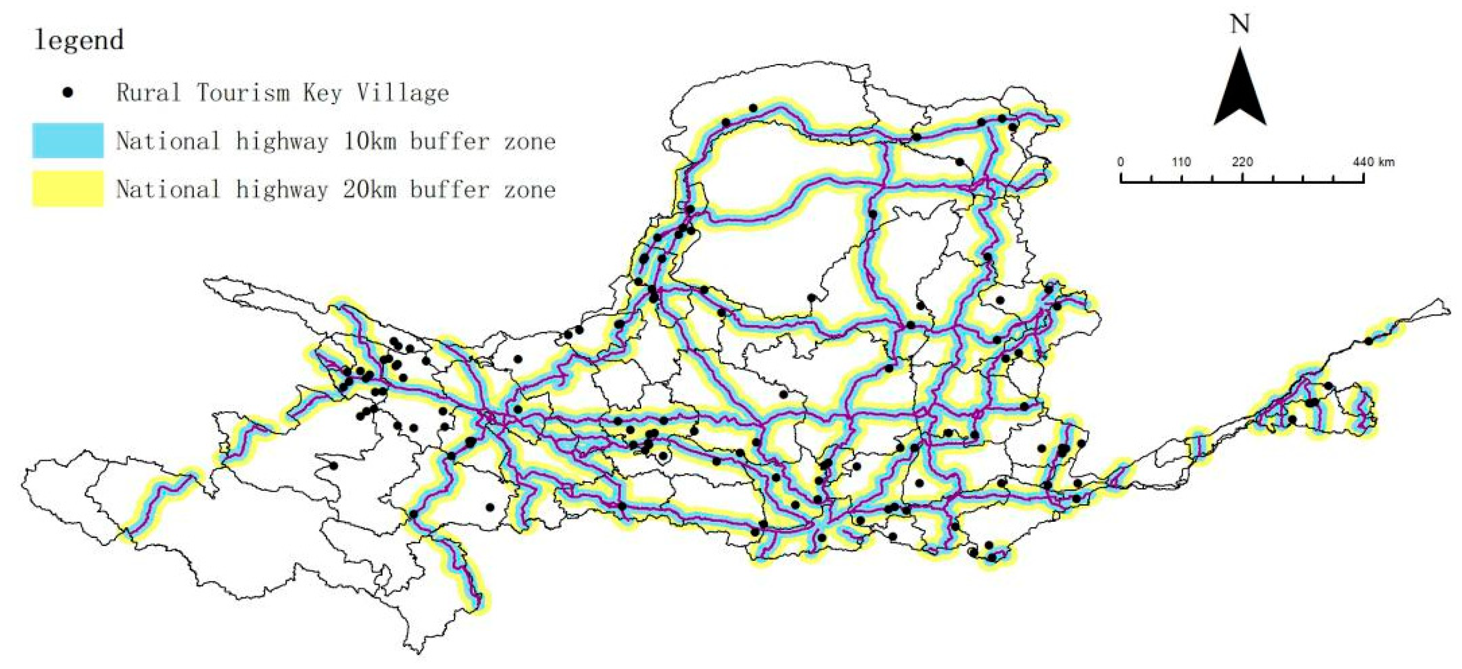
4.2.2. Traffic Location Conditions
Transportation is an important factor for the creation of key villages in the Yellow River Basin. It not only exists as a unique tourism space [
66] but also plays a role in guiding tourists and exporting agricultural products. In the post-COVID-19 epidemic era, travelers have begun to focus on safety and comfort, and rural tourism characterized by short traveling distances, low population density regions, and short intervals, and a slow pace has gradually emerged. As presented in
Figure 6, 10 km and 20 km buffer zones along the main national roads in the Yellow River Basin have been established, and the results indicate that the distribution characteristics are significant. In the 10 km and 20 km buffer zones along the national highway, there are, respectively, 26 and 89 key villages, which account for 24% and 75% of the total, respectively. This demonstrates that transportation location is an important factor affecting the spatial distribution of key villages in the Yellow River Basin.
4.2.3. The Level of Economic Development
Based on the previous spatial hot spot analysis and kernel density analysis, it was found that the key villages in the Yellow River Basin are mainly concentrated near cities with relatively developed regional economies. Therefore, the tourism economic indicators (total tourism revenue) and GDP indicators of the provinces and regions in the basin were utilized to measure the impacts of regional social economic development on the distribution of the key villages. The calculation results demonstrate that the connection rates between the distribution of the key villages and the tourism economic indicators and GDP indicators are, respectively, 99.5 and 98.7. This shows that the spatial distribution of the key villages in the Yellow River Basin is strongly related to the level of social economic development. The analysis also reveals that rural tourism agglomeration has high requirements for the introduction of large-scale investment, refined product development, characteristic cultural displays, and high-quality service experience [
67], which will inevitably lead to an economic orientation of rural tourism construction and impose certain requirements on the level of regional economic development.
4.2.4. Policy Environment Factors
The support of national and local government policies has played an important guiding role in the construction of the key villages in the Yellow River Basin. Since the Ministry of Culture and Tourism of China announced the first batch of key villages in 2019, it has continuously introduced new policies to support the development of these villages. In the same year, the General Office of the Ministry of Culture and Tourism of China and the Office of the Agricultural Bank of China jointly issued the “Notice on Further Strengthening Financial Support for the Construction of Key Villages in Rural Tourism across the Country,” which clearly indicated the enhancement of financial support for the construction of key villages. In October 2020, to promote the development and construction of key villages and improve the quality and efficiency of their development, the China Resources Development Department organized a training course on key villages. Moreover, the rural revitalization strategy has been closely followed, and relevant policies have been introduced to promote the sustainable development of key villages.
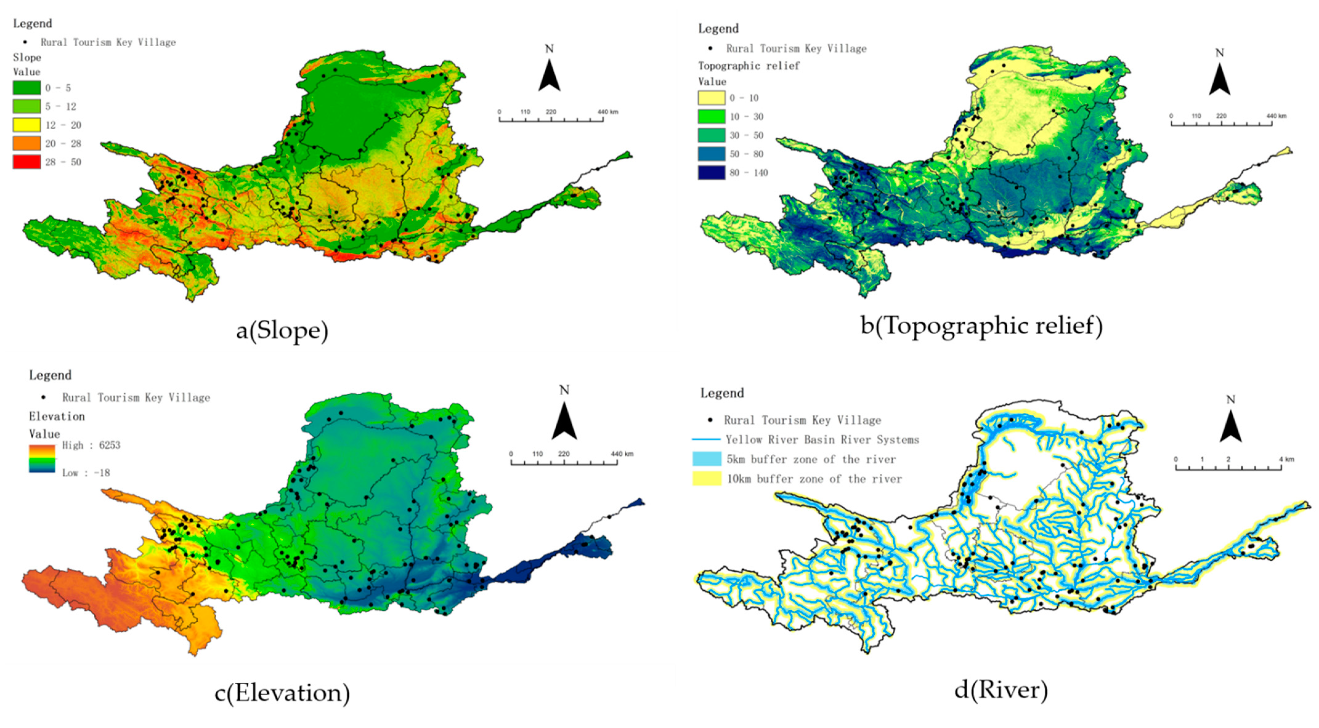
4.2.5. Topographic Factors
The Yellow River Basin is located at the junction of the three-tiered terraces of China’s topography. Similar to the topography of the whole of China, the topography of the Yellow River Basin is complex and diverse and is characterized by higher elevation in the east and lower elevation in the west. In addition, the Yellow River Basin has formed various types of complex landforms, including wind erosion landforms, cave landforms, and Yellow River stone forests. The diverse and complex topography is also an essential element and foremost condition for the improvement of the quality of tourism resources in the basin and the composition of the rural tourism landscape.
To further clarify the impact of topography on the spatial distribution of the key villages in the Yellow River Basin, the slope, topographic undulation, and elevation were analyzed.
The slope is the angle between the projection of the normal vector of the tangent plane of a point on the ground surface on the horizontal plane and the true north direction passing the point. The slope exerts an important restriction on the layout of key villages [
68]. In this study, the digital elevation data of China’s DEM with a resolution of 90 m was superimposed on the distribution of the key villages in the Yellow River Basin. It can be seen from
Figure 7a that there are 32 key villages in the slope range of 0–12°, accounting for 25.2% of the total; there are 74 key villages distributed in the slope range of 12–20°, accounting for 58.3% of the total; finally, there are 21 key villages distributed in the slope range of 20–28°, accounting for 16.5% of the total.
Terrain undulation mainly refers to the difference between the maximum and minimum altitudes in the study area, and is used to reveal the macroscopic features of the topography and surface of the study area [
69]. A terrain relief map was generated via neighborhood analysis and raster calculator tools, as presented in
Figure 7b. It is evident from the figure that the key villages in the Yellow River Basin are mainly distributed in the areas with few topographic undulations. The numbers of key villages with 1, 2, 3, 4, and 5 topographic undulations account for 26.1%, 21.8%, 19.4%, 23.8%, and 8.9% of the total, respectively. In addition to the relatively high proportion of key villages in the range of 50 to 80 m, the number of key villages was found to exhibit a decreasing pattern with the increase in the value of topographic undulation.
Differences in altitude and topographic undulation directly produce different combinations of water and heat, which in turn affect the local agricultural production methods and village site selection [
70]. As presented in
Figure 7c, an elevation map was generated, from which it is evident that the key villages in the Yellow River Basin are mainly distributed in the western mountainous area of the basin, the Ningxia Hetao Plain, and the southern foothills. The western area mainly includes Wushaoling, Daban Mountain, and Laji Mountain. Moreover, the Ningxia Plain is bordered by Shizui Mountain in the north and Helan Mountain in the west; the Yellow River runs diagonally through it and forms a vast artesian irrigation area. The southern area includes the Liupan Mountains, Zhongtiao Mountains, and Qinling Mountains; the terrain in this area is complex, and the altitude is relatively high. The mountainous natural geographical conditions directly affect the farming conditions, production, and life of the residents. Therefore, the villages and towns are mainly distributed along the rivers and foothills.
In general, from the perspectives of the slope angle, topographic undulation, and elevation, the characteristics of the spatial distribution of the key villages in the Yellow River Basin are relatively similar; except for a small number located in areas with higher topography, most key villages are located near river valleys, mountain foothills, and other relatively flat areas. These key villages are distributed in areas with gentle terrain, and they have become the first choice for urban residents to travel due to their proximity to cities and source markets, flat terrain, and convenient transportation networks. Moreover, the key villages characterized by relatively steep terrain can provide tourists with a unique experience due to their original village appearances and a sense of tranquility due to their locations far from the hustle and bustle of the city. The natural and geographic conditions of the mountains and hills in the central and western parts of the river basin have caused these areas to have poor economic levels with a large number of villages with high poverty levels; when selecting key villages, local governments will give preferential treatment to these areas. This has also become another important factor affecting the distribution of key villages in steep terrain.
4.2.6. River Water System Factors
As one of the main factors affecting the spatial distribution of resources, river systems are an important material basis for human production and life and are the birthplaces of various cultural heritages [
71]. The Yellow River Basin is densely covered with river networks and crisscrossed watercourses, and the main roads of the Yellow River have been developed by multiple independent lake basins for millions of years. In addition to the main roads of the Yellow River, there are more than a thousand rivers distributed in the region. The rivers nurture fertile plains, provide suitable material conditions for the production and life of residents along the river, and were the basic element of the origin of Yellow River civilization. Moreover, a unique natural water landscape has formed around the Yellow River Basin. In this study, ArcGIS 10.2 software was used to analyze the 10 km buffer zones of the first, second, and third tributaries and the 5 km buffer zones of the fourth and fifth tributaries (
Figure 7d). The results demonstrate that there are 114 key villages distributed in the river buffer zones at all levels, accounting for 89.7% of the total. The key villages in these areas are the most densely concentrated. Furthermore, the number of key villages was found to decrease with the increase in the distance from the water area, thereby exhibiting obvious hydrophilic characteristics.
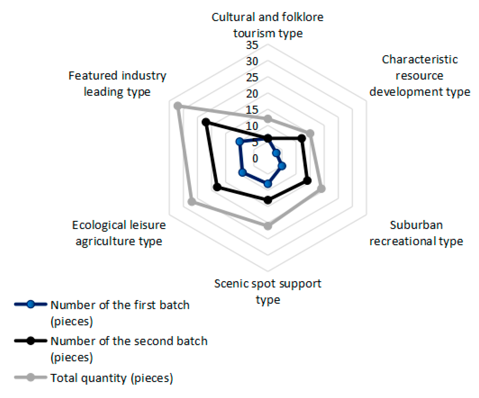
4.3. Industry Classification
The establishment of key villages is an important key point for solving China’s “three rural issues” and promoting the sustainable development of the rural economy, the role of which in modern agricultural construction and rural revitalization cannot be underestimated. Based on the unique advantages of the key villages, the development of products that meet the needs of the market according to local conditions is the only path to their sustainable development.
No accurate conclusion on the classification of rural tourism types has been reached. In the course of this research, the formation and development process and essential characteristics of the newly announced second batch of key villages were combed. Based on the unique natural resources of the Yellow River Basin and the differences in regional cultural endowments, and in consideration of various factors, the criteria for the classification of key villages by scholars such as Ma were selected [
72]. The findings presented in
Figure 8 reveal the following:
The number of characteristic industry-led villages is the largest (32), accounting for 25.4% of the total. Based on the differences in the resource endowments of the Yellow River Basin, the characteristic industry-oriented type can be further divided into the agriculture-oriented type, handicraft-oriented type, and animal husbandry-oriented type, and others. The agriculture-oriented industry type is mainly based on the industries of vegetables and fruits, forest trees, native products, and flowers (e.g., Linyingzi Village, Shijia Township, Harqin Banner, Chifeng City). The handicraft-oriented industry type is dominated by handicrafts, paper-cutting, embroidery, stone tools, and carvings (e.g., Tiefosi Village, Yunyang Town, Nanzhao County, Nanyang City). The leading type of industry, namely, animal husbandry-oriented industry, mainly involves the raising of cattle, sheep, sika deer, and camels (e.g., Qianzhuang Village, Guanzhuang Township, Longde County, Guyuan City).
The proportion of key villages characterized by ecological leisure agriculture is relatively large; these 27 key villages account for 21.4% of the total. Key villages relying on scenic spots, suburban leisure, and recreation were found to compose the middle proportion and account for 16.7%, 15.1%, and 11.9% of the total, respectively. The number of key villages characterized by cultural and folk-custom tourism is the least (12), accounting for only 9.5% of the total. Cultural and folk-custom villages have higher requirements for characteristic folk-custom architecture, cultural space, and inheritance environments, and village folk-custom culture is quickly becoming lost due to the development of modern urbanization, resulting in the comparatively small number of cultural–folk-custom villages.
Overall, the key villages in the Yellow River Basin have formed an industry structure characterized by dominant characteristic industries and a scarcity of cultural and folk-custom tourism types. In consideration of the preceding conclusions, the spatial distribution of the various types of key villages also exhibits certain trends. First, relying on their topography and other natural geographical advantages, a cluster of villages dominated by agriculture is formed in basins and valleys with low-altitude terrain and close to rivers. Second, relying on their resource advantages, some key villages, such as those in Inner Mongolia and parts of Ningxia, have formed an agglomeration dominated by animal husbandry, and the Guanzhong Plain and Fenhe Valley are characterized by villages with profound cultural heritage. Folk craftsmanship has been effectively inherited, and various types of characteristic palaces and buildings have been preserved. Therefore, there are large numbers of cultural, folk-custom, and scenic-reliant key villages. Third, relying on the geographical advantages of neighboring cities, such as urban and rural leisure and recreation, key villages relying on the city’s high consumption capacity and tourism demand provide a stable source of tourists for the development of rural tourism.
4.4. Rural Transformation and Development Mechanisms Driven by Tourism
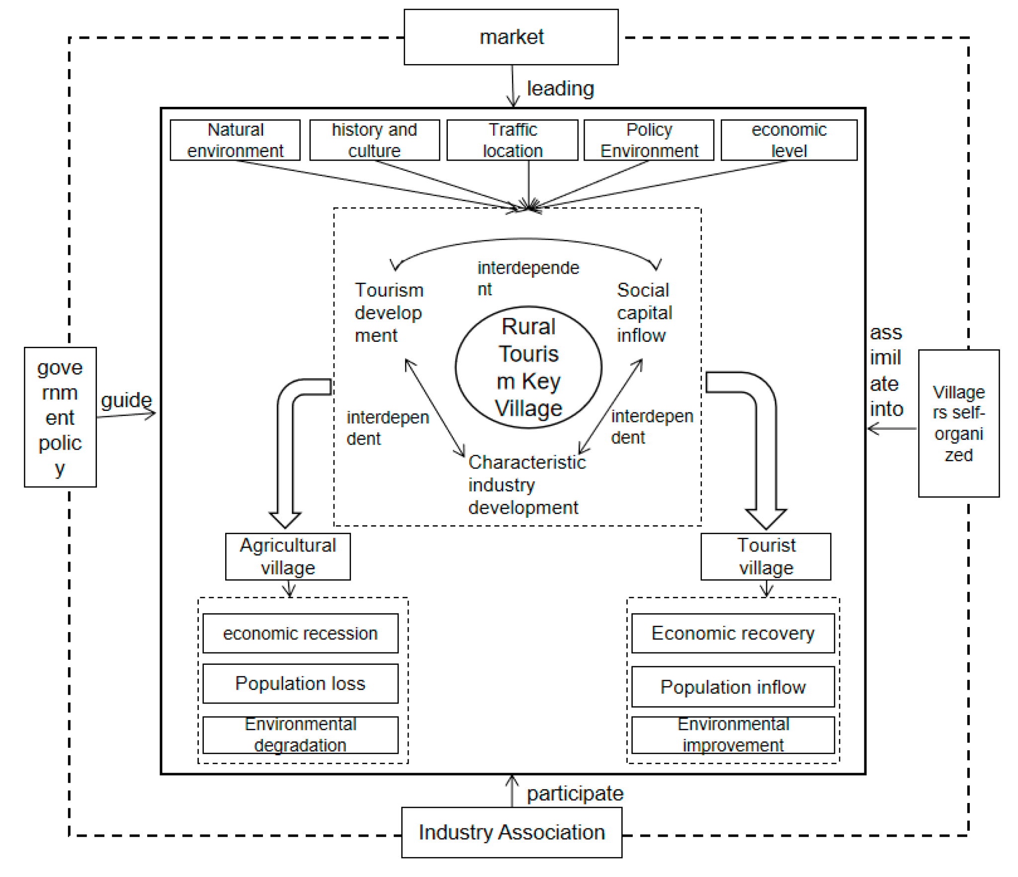
Based on the preceding analysis and conclusions, and in combination with the theory of rural development transformation, the mechanisms behind tourism development of the key villages in the Yellow River Basin are subsequently put forward. As shown in
Figure 9.
The spatial distribution of the key villages in the Yellow River Basin is affected by a variety of factors; these factors affect the economic, population, and industrial structure of the key villages and will have a sustained effect. Driven by the ecological protection and high-quality development strategy of the Yellow River Basin and the rise in national tourism demand in the post-COVID-19 epidemic era, rural tourism has continued to gain national travel popularity due to its advantages of being short distance and slow paced. The various provinces and autonomous regions of the Yellow River Basin have issued relevant policies to support tourism, and large amounts of capital, manpower, information, and other elements have begun to flood into the basin, which have also introduced opportunities for the development and upgrading of rural characteristic industries. During this process, the tourism industry and characteristic industries complement each other in terms of infrastructure, capital, labor, and products, and the two exhibit a trend of joint development [
73]. Driven by a series of changes in factors, the economic structures of the key villages in the basin have also begun to change from traditional agricultural-oriented villages to tourism-oriented villages. Specifically, considering the structure of traditional agricultural villages, driven by economic interests, a large number of young and middle-aged laborers in rural areas have begun to enter cities; consequently, villages have become hollowed out, and rural governance capabilities have declined. With the deterioration of the rural environment, the capacity of rural economic development has also declined. Furthermore, due to the development of rural tourism and the flow of various elements, the element structure of traditional agricultural villages has begun to change, such as via land appreciation, capital accumulation, and labor appreciation. The development of rural tourism has started to become the mainstream, and a portion of the labor force has started to return. Villagers have transitioned from traditional small-scale farming to the development of intensive agriculture, and have promoted the development of local leisure agriculture and characteristic industries. The local area has gradually formed a dual livelihood structure including both agricultural and tourism livelihoods. With the diversification of the rural livelihood structure, the rural economy has begun to flourish, and rural governance has also received further attention. The rural environment has been improved, which also provides a more suitable environment for the development of rural tourism. As the “people–land–industry” structures of the villages have started to change, village functions have begun to diversify, and rural governance capabilities have been greatly improved. The key villages are gradually being led by the government and are beginning to transition to self-organized management.
The key villages remain in the initial stage of development led by the government. With the continuous influx of social capital in the future, the main body of marketing around the key villages will be reshaped, and the formation of a new path to sustainable development will require the participation of stakeholders such as the government, the market, industry associations, and villagers. As the leader of the economic development of regional rural tourism destinations, the government should play an active role in guiding self-employed operators and industry associations to reasonably participate in operations, as well as in brand building of rural tourism destinations, and should effectively disseminate the multi-brand strategy of rural tourism destinations. On the basis of government guidance and resource brand integration, the main body of industry associations and self-employed individuals will strengthen their own brands, center on the regional characteristics of the key villages, form independent individual brand advantages, and expand brand publicity. As villagers and other operators are the direct or indirect beneficiaries of rural tourism, the actions of local villagers and stakeholders will directly affect the brand communication of rural tourism destinations. The government should play the role of an intermediary and actively guide local villagers to become supporters and partners in the development of rural tourism destinations. In the entire marketing system, the government acts as the leader, and the market operators act as the followers. This forms a nationwide open marketing cooperation system with local villagers and associations to jointly build regional brands and promote the sustainable development of rural tourism destinations.
5. Conclusions and Discussions
5.1. Conclusions
Via the use of ArcGIS software, mathematical models including the nearest-neighbor index, the imbalance index, and global spatial autocorrelation were employed in this research to quantitatively analyze the spatial structure and influencing factors of rural tourism villages in the Yellow River Basin. The main conclusions of this research are as follows. In terms of their spatial distribution, the key villages in the Yellow River Basin exhibit obvious agglomeration characteristics. The nearest-neighbor index was found to be R = 0.66, indicating that the key villages are spatially condensed and distributed. The imbalance index was found to be G = 0.307, and the Lorentz curve was found to exhibit a downward trend, which further illustrates the imbalanced spatial distribution of key villages. The spatial distribution reveals that the key villages present a distribution pattern of increased concentration in the west and south as compared to the east and north, respectively, and exhibit a distribution pattern of “one core and one belt”. Due to the complexity of the topography of the Yellow River Basin, the distribution of rural tourist destinations is also characterized by complexity and diversity.
This research focused on the spatial distribution pattern of key villages, and six major factors, namely, historical culture, transportation locations, economic development, the policy environment, topography, and river systems, were ultimately selected for analysis. Historical culture was found to have a significant impact on the distribution of the key villages; the villages are distributed around ancient towns with long historical and cultural accumulation and strong folk customs. Ancient towns are densely populated, and their agricultural production activities are concentrated, which promotes the formation and development of rural tourism. The analysis of the transportation location factors revealed that convenient transportation in rural tourist destinations directly affects the accessibility of rural areas. Key villages are largely located within 50 km of a municipal government, and citizens are more inclined to travel short distances. The development of rural tourism destinations and their proximity to urban centers have positive effects on tourism development, which is consistent with the conclusions of existing research. Moreover, a strong correlation was found between the level of economic development and the distribution of key villages, which indicates that the residents in areas characterized by higher economic development have higher requirements for rural tourism and leisure and are more willing to pay for rural tourism services. In addition, government support has also become an important driving factor. The analysis of topographic factors revealed that low, gentle, and flat areas have become the main areas for the distribution of key villages, but rural tourist villages in areas with relatively steep slopes and terrain can provide different experiences to tourists and also have high tourism value. The development of rural tourism is of great significance to poverty alleviation in these areas. Consistent with the existing conclusions, the distribution of rural tourist destinations revealed a greater concentration near the river source and a decreasing concentration with the increase in the distance from the water area, thereby exhibiting hydrophilic characteristics. In short, these factors are of great significance for promoting the sustainable development of rural tourism. Finally, the transformation and development mechanism of rural tourism destinations in poverty-stricken areas was analyzed, and the general laws of rural tourism development were effectively summarized, which has important reference value for the sustainable development of rural tourism destinations in poverty-stricken areas in other developing countries.
5.2. Discussions
Based on a comprehensive analysis of the spatial distribution characteristics and influencing factors of rural tourism destinations, this research analyzed the spatial distribution of rural tourism destinations in the Yellow River Basin, and the principles of and countermeasures to sustainable development are put forward from the perspectives of sustainable livelihoods, rural governance, and marketing.
Sustainable livelihoods are widely considered in rural tourism development and rural transformation research. The sustainable livelihood framework proposed by the British Overseas Development Department is the most widely used [
74], and some scholars have obtained additional results [
75]. As a regional subsystem of the Yellow River Basin, the Qinba Mountainous Area is a concentrated contiguous and extremely poor area announced by the Chinese state. Research on this area represents the epitome of rural tourism development in the impoverished areas of the Yellow River Basin. Drawing on existing research results [
76], some strategies by which to achieve sustainable livelihoods related to rural tourism in the Yellow River Basin are proposed. For tourism livelihoods exhibiting differences in poverty reduction in different regions and considering the fragility of the tourism industry itself, river basin provinces and regions should be treated dialectically. For example, for the mountainous areas in the western region, it is difficult for agricultural production to be intensive and large scale. Under the premise of ensuring the efficient cultivation of part of the agricultural land, local advantages should be used to develop handicraft agricultural products and other industries; these industries should then be combined with rural tourism to establish an “agriculture + tourism” dual livelihood structure, increase farmers’ livelihood capital, and enhance farmers’ economic resilience. In the face of force majeure disasters such as the COVID-19 epidemic, the stability and sustainable development of the rural economy should be maintained via reasonable allocation of land resources and the direct use of collective rural land in the market; the government should provide opportunities for large-scale land dividends in rural areas and reasonable arrangements for collective rental housing, broaden the income channels of farmers and the collective economic structure, and improve the level of diversification of livelihoods. Furthermore, attention should be paid to the advantages of regional tourism resources, and the transformation of the local industrial structure should be promoted via the flow of capital and other elements.
Farmers and private enterprises should be encouraged to actively participate in the management and construction of key villages. At present, the establishment of key villages is mainly an endeavor led by the government, and the participation of social capital remains very limited. The government should relax the threshold of capital entry, encourage capital participation and farmers’ autonomous operation, and integrate the follow-up developments and construction of key villages into the economic market. During this process, attention should be paid to the relationships between the interests of provincial governments, enterprises, and farmers of local villages in the river basin. Moreover, measures should be adapted to local conditions; a rural tourism development model that conforms to the regional characteristics of the Yellow River should be adopted, and model homogeneity should be avoided. Some studies have shown that due to the infusion of external social capital and the dominance of the local government in some impoverished areas where ethnic minorities gather, local villagers will gradually be marginalized [
77]. For example, some villages in the Enshi Prefecture of China have conflicts of interest with local villagers in the process of participation of foreign capital, and the villagers have become gradually marginalized and remain in a passive position. With the gradual adjustment of China’s national policies in recent years, people-centered concepts and connotative development have begun to become mainstream. “The Rise of Central China”, “Western Development”, and “Yellow River Basin Ecological Protection and High-quality Development” have systematically increased the power of ethnic minority areas to a certain extent, thereby driving local governments to support the local economy and guiding villagers to start self-organized management developments [
78]. For example, in the process of promoting the development of local commercial agriculture by the Lijiang government and due to foreign capital, local villagers have gradually exerted their influence on local economic development and have transitioned from passive receivers to active managers [
79]. Provincial governments in the basin can learn from regional development experience, strengthen the mechanisms of the identification of the introduction of social capital, gradually delegate powers in guiding villagers to independently participate in the management of key villages, increase the enthusiasm of local villagers to participate in construction, and establish an institutional management mechanism.
The marketing and publicity efforts for rural tourist destinations in poor mountainous areas should be strengthened. Existing research shows that some rural tourist destinations are affected by various internal and external factors, and fail to promote the sustainable growth of the rural economy. In terms of rural tourism marketing, insufficient market research, publicity, and professional marketing talents have become the greatest shortcomings hindering the development of rural tourism. Based on the previous analysis of rural tourism transformation and marketing systems, the basic principles of and countermeasures for rural tourism destination marketing are summarized as follows: as rural tourism is a component of the service industry, the design of tourist-oriented marketing strategies is of great significance to the development of rural tourism. The consumer-centered 4 C theory (the 4 Cs marketing theory) has been widely used in previous research. Starting from the needs of consumers, the rural cultural connotations of historical culture, folk customs, and natural pastoral roots in rural tourism destinations should be developed; the authenticity of the local culture should be retained; and tourists should be allowed to feel the charm of the countryside. During the process of pricing rural tourism products, prices and costs should be reasonably controlled, and the affinity and competitiveness of prices will become key factors in attracting repeat customers. Moreover, diversified marketing channels should be constructed, and the resources of communication channels should be integrated on the basis of Internet marketing to provide convenience for tourists. By designing diversified promotional methods and maintaining effective communication with tourists via the reasonable selection of media platforms, tourists can have a deeper understanding of the characteristics of rural tourism destinations, and the purpose of communication in rural tourism destinations can be achieved. The summarized marketing theory principles as related to rural tourism destinations can be effectively applied to other rural tourism destinations to provide effective advice and value.
This paper investigated the spatial characteristics, influencing factors, and mechanisms of rural transformation in the key villages in the Yellow River Basin, and the findings are of great significance for the sustainable development of rural tourism. However, this study was characterized by some research deficiencies that are worthy of in-depth discussion in the future. (1) The first two batches of key villages as announced by the Chinese state were analyzed in this study. After a systematic review, it was found that only 127 key villages were located in the Yellow River Basin. In view of the small number of samples, the key villages were only analyzed from a spatial cross-section perspective, and research on temporal cross-sectional data remains lacking. In the future, more systematic quantitative indicators can be determined based on the successively published data of key villages to conduct comprehensive research from a spatiotemporal perspective. (2) This article only analyzed the factors affecting the key villages from the perspectives of historical culture, social economy, and physical geography. Factors such as the relevant interest groups of the key villages, the sense of belonging of the villagers’ within their communities, and the actual needs of tourists were not explored; these factors are worthy of follow-up research using a combination of both qualitative and quantitative methods. (3) The analysis of the rural tourism transformation and sustainable development mechanisms conducted in this study was only a preliminary discussion. As rural transformation mechanisms involve additional interest groups, a comprehensive analysis based on field investigations is required. The determination of how to achieve the successful transformation of rural tourism in poverty-stricken areas while ensuring the interests of all parties will be another future research direction.


