Article

Analysis of Social Networks of Water-Use-Related Information in the Rio Mayo Irrigation District (038) in Northern Mexico: Ethnicity, Land Tenure and Land Use

by
Ixtoc Marlo Rivera-Nuñez
1,*,
Diana Luque Agraz
1,
Arthur D. Murphy
2 and
Eric C. Jones
3
1
Centro de Investigación en Alimentación y Desarrollo A.C., Hermosillo 83304, Sonora, Mexico
2
Department of Anthropology, The University of North Carolina at Greensboro, Greensboro, NC 27402, USA
3
School of Public Health, University of Texas Health Science Center at Houston, Houston, TX 77030, USA
*
Author to whom correspondence should be addressed.
Water 2023, 15(12), 2288; https://doi.org/10.3390/w15122288
Submission received: 28 April 2023 / Revised: 13 June 2023 / Accepted: 14 June 2023 / Published: 19 June 2023

Abstract

:
(1) Background: In Mexico, 76% of water consumed is used for crop irrigation, and close to half of this is used in 86 irrigation districts for agroindustry throughout the nation. The present study combines a political ecology approach with social networks analysis to identify how water-use-related information networks are structured according to the ethnicity (indigenous and non-indigenous) of the users of the Rio Mayo Irrigation District 038 (RMID) and how these networks are influenced by users’ type of land tenure and land use. (2) Methods: The study involved three stages: identification of social actors that influence water management (SAIWM); application of 118 structured interviews with users of RMID; and ethnographic fieldwork. (3) Results: Thirty SAIWM were identified. Only 11.8% of RMID users interviewed were indigenous farmers and only 5% were indigenous holders of collective landholdings. The information network metrics indicate that indigenous users have less access to information than non-indigenous users. (4) Conclusions: Ethnicity as well as land tenure and land use influence the structure of information networks and determine whether RMID users work as land-holding farmers or as hired labor.

1. Introduction

Conflicts over water are increasing worldwide, associated with the current environmental crises [1]. It is estimated that on a global level, 69% of water consumed is used for agriculture [2]. In Mexico, 76% of water consumed is used for 7.32 million hectares of industrial agriculture [3], of which approximately 3.3 million are under the jurisdiction of Mexico’s irrigation districts. Irrigation districts are established by a Presidential Decree and consist of one or more delimited surface areas, within which a district is located. This district includes hydraulic infrastructure, surface water, and groundwater, as well as storage vessels, a federally owned zone bordering all rivers, a protected area, and other associated property and infrastructure. One or more irrigation modules may also be established within these districts. Mexico’s Law of National Waters: XXV. A. (https://www.diputados.gob.mx/LeyesBiblio/index.htm, accessed on 13 January 2023). Furthermore, 4.02 million are under the jurisdiction of irrigation units, which are crop areas with irrigation systems and other infrastructure, typically with lesser surface areas than those of irrigation districts. They may consist of associations of users or groups of farmers who jointly organize to receive the service of irrigation. Under autonomous management, these groups operate hydraulic infrastructure for catchment, diversion, conduction, regulation, distribution, and discharge of federal water for agricultural irrigation. Mexico’s Law of National Waters: XLVI. A. (https://www.diputados.gob.mx/LeyesBiblio/index.htm, accessed on 13 January 2023) [4]. A total of 86 irrigation districts are located throughout northern and central Mexico, in which principally monocultures are produced, including maize (39.6%), wheat (14%), sorghum (8.7%), and alfalfa (5.5%) [4].
Many of the irrigation districts include indigenous territories [5,6], in which “colonization” by new social actors carrying out industrial capitalist agriculture is displacing subsistence production [7,8,9]. These large-scale producers generally have access to information that in turn facilitates their access to inputs throughout the agricultural season, such as water, land, labor, capital, and technological packages. Even though the original small-scale farmers possess land, they have less power and access to such information, and are therefore excluded from mechanisms to obtain credit, input, and machinery; marketing circuits; and other aspects of the industrial agriculture chain [9,10,11,12]. As a result, they often end up renting out or selling their land, along with their water rights, and working as laborers on land that is or was theirs.
Physical–material access to water is unequal and intersectional, since structural and individual factors interact, such as sociopolitical processes, technological and economic factors [13], age, gender, ethnicity, language, socioeconomic level, educational level, and land tenure status [14], which generate asymmetries of power and users with heterogeneous physical–material access to water. Even though being a user of an irrigation district guarantees water rights “on paper” (or de facto water rights [15]), discrepancy exists between the volume of water assigned and the real volume that reaches the plot. This may be termed the arena of dispute over water, whereby each user must use the means and resources available to them to assure their access to water. Thus, the study of water access should not be limited to the volume assigned; rather, there is a need to identify the role of social actors charged with water management and the way they treat irrigation district users in a differentiated manner. For this reason, the analysis of social networks allows a methodological approach to understand physical–material access to water as a problem of a sociopolitical nature.
Therefore, the objective of the present study is to identify how social networks of information exchange interact regarding water management between social actors influencing water management and users of Rio Mayo Irrigation District 038 (038 is the “key number” assigned by the Federal Government at the time of its creation; it is omitted from now on) according to their ethnicity and what the type of land tenure and land use the users have.
Among the users (in this text, users refer to those people who have a land title within the irrigation district and therefore have a right to irrigation water, whether from the local dam or a well; these users include both private property owners as well as collective landholders) of Rio Mayo Irrigation Districts, two principal ethnic groups were identified: indigenous and non-indigenous. The indigenous inhabitants of the area are of prehispanic Mayo origin (the Mayo people are legally recognized as an indigenous group in Mexico. While they call themselves Yoreme, this study uses the conventionally adopted term Mayo, which they accept) and the non-indigenous inhabitants are descendants of European colonizers as well as mestizo migrants that for centuries have moved to the region. The ontological conception of water differs between both ethnic groups. While the Mayo consider water a central part of their worldview and give it a symbolic value associated with their river and its cultural manifestations, non-indigenous people limit it to a raw material for agricultural production; that is, they consider it only a material resource.
This irrigation district was selected for study because of its unique system of assigning water to users, by which—at least according to their de facto rights—all users are assigned the same amount of water regardless of their personal attributes (ethnic origin, language, age, gender, etc.) or the characteristics of their plot (type of land tenure, size, location, type of crop, etc.).
This research is novel because it transcends de facto rights by combining the water political ecology approach with social network analysis to identify differentiated access to information related to water use, which facilitates the understanding of a structural problem. Secondly, existing research focuses on social relations at the institutional level or at the user level, leaving aside the inherent relationship between them; for this reason, we consider both parties. Finally, according to the literature review conducted for this research, to the best of our knowledge, no work has been carried out that combines these approaches in the irrigation districts in Mexico.
The present article consists of seven sections. Following this introduction, we present an approach addressing the political ecology of water in an agro-industrial context by using the methodological framework of social networks analysis. The Section 3 describes the study area and summarizes the history of water rights in Rio Mayo Irrigation District, involving exclusion of the indigenous Mayo people from these rights as a result of agroindustry renting their land. The Section 4 presents the research methodology used, and Section 5 and Section 6 present and discuss the results. Finally, the conclusions are presented.

2. Political Ecology of Water and Social Networks Analysis of Water-Use-Related Information

Political ecology combines multiple disciplines to analyze “the relationship between economics, politics, and nature” [16]. According to Boelens and collaborators [17], political ecology focuses on the conflicts and contradictions among social actors that have unequal access to natural resources. Intense debate promoted by Latin American academia and social movements regarding the territorial processes of these movements has given rise to a Latin American school of political ecology [18].
Meanwhile, social networks analysis uses visualization and metrics to establish analytical relationships that contribute to the structural analysis of society [19]. Social networks analysis allows for transcending formal hierarchical relationships by relating attributes of the study subjects to the position they occupy in a network. Links analyzed in the networks refer to relationships among two or more actors. Flow of information is one such type of link of extreme importance that has been analyzed, for example, in studies of disasters [20,21] and governance of natural resources [22,23]. As in the present study, social networks analysis may be combined with a political ecology approach to facilitate comprehension of differentiated access to a resource as a structural issue.
While social networks analysis studies of environmental topics have focused on the dilemma of cooperation vs. conflict over a natural resource, little attention has been devoted to the negative links in these interactions, for example those involving competition or antagonism [24]. Furthermore, what has been termed governance networks [25] either exclusively focus on social relations among actors on an institutional level (those belonging to formal or informal organizations), or on the level of users, leaving aside the inherent conflict between users and institutions upon managing the natural resource. There is a need to contemplate both parties, as well as identify the structure of the network of differentiated access and use of the natural resource in question and how the benefits and disadvantages of their use are distributed.
Mapping social networks of the flow of water-use-related information may contribute to comprehension of the hydrosocial system in several ways. For example, it has been found that analyzing links of information: (1) may be an unbiased manner of analyzing power [26]; (2) indicates which types of users are more resilient [27]; (3) represents the interests of different actors in an impartial manner, thereby avoiding marginalization of less powerful groups [28]; (4) identifies local actors who are moral leaders and may facilitate collective learning and action [29]; (5) indicates that the attributes of the users influence the type of information that they share [30]; (6) analyzes the manner in which organizations or institutions react in the face of a threat [31]; (7) identifies how the quantity of information shared among social actors generates complex structures that facilitate conflict resolution [32]; and (8) indicates challenges to implementing a policy of collaborative governance [33] or a global water agenda [34]. Given the variety of approaches used in studies of information networks, it is important to achieve concordance between the disciplinary framework and the methodological design of the study, including congruence between the study objectives and the network metrics used for structural analysis.

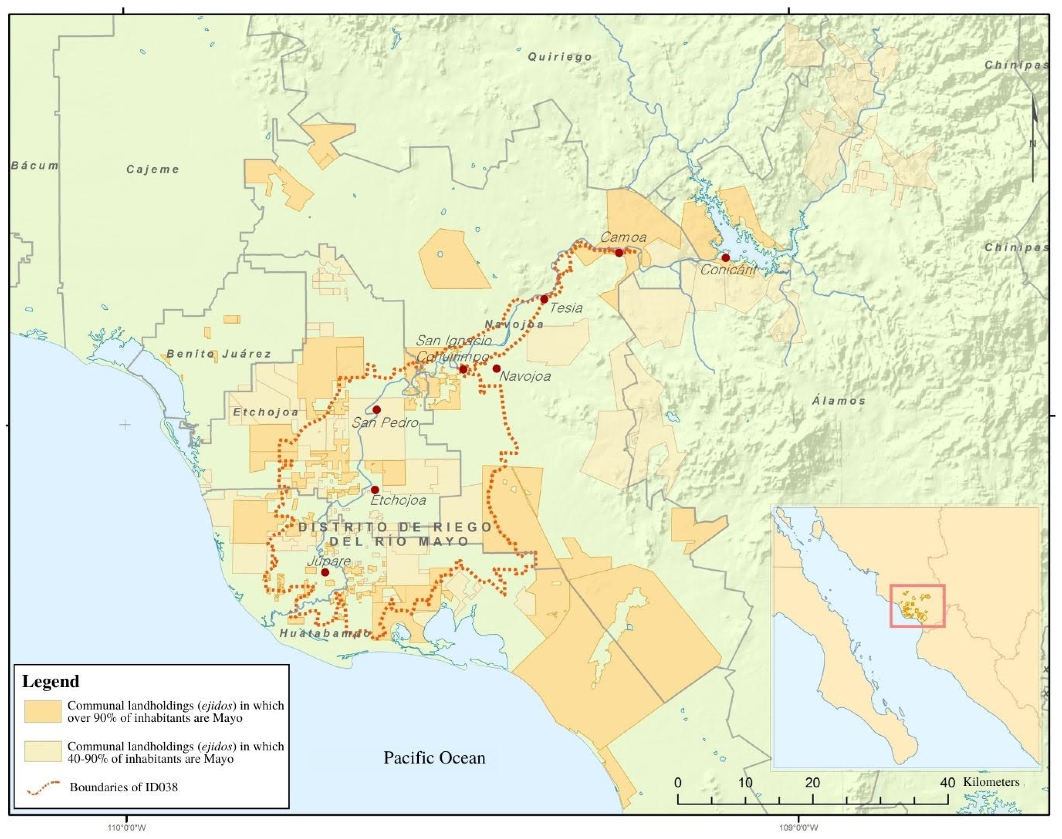
3. Rio Mayo Irrigation District

The Rio Mayo Irrigation District is located in the lower Rio Mayo watershed, in the southern part of the northeast Mexican state of Sonora. The river originates in the Western Sierra Madre and flows out into the Gulf of California. The Mayo watershed is one of the most biodiverse regions in the state of Sonora and is an area for the protection of wild flora and fauna and a priority hydrological watershed [35]. In it there are 20 different vegetation types, including low jungle, desert, and coastal vegetation, as well as industrial and peasant agriculture [6]. Figure 1 shows the Rio Mayo Irrigation District polygon, located in the coastal valleys of the watershed.
The Rio Mayo Irrigation District includes three municipalities—Navojoa, Etchojoa, and Huatabampo—and has a population of 303,378 [3]. Two principal ethnic groups are distinguished in the region: the Mayo indigenous group of prehispanic origin, and the non-indigenous population (locally known as Yori, according to the Mayo term), including descendants of European colonizers as well as mestizos. As a result of centuries of inmigration, cultural mixing, and demographic growth, the non-indigenous inhabitants make up 83% of the population, while the remaining 17% consider themselves to be indigenous [36]. The current Mayo population, estimated at 65,000, is concentrated in the riverside villages of the Rio Mayo, particularly in eight traditional villages, i.e., Conicarit, Camoa, Tesia, Navojoa, San Ignacio Cohuirimpo, San Pedro, Etchojoa, and Júpare, all of which fall within Rio Mayo Irrigation District (see Figure 1). Their culture revolves around the Rio Mayo, and their political organization is based on their traditional village governments which principally coordinate ceremonial matters, as well as on the territorial organization of their collective landholdings, including both “communal lands” granted by the Mexican state as restitution of indigenous land prior to the conquest and ejidos formed after the Mexican Revolution.
As a delayed result of the 1910–17 Mexican Revolution, in 1956, between the first and second wave of land repartition in the region (1938 and 1976, respectively), the Rio Mayo Irrigation District was created using irrigation channels constructed at the beginning of the 20th century by business investors [37]. Currently, the irrigation district infrastructure also includes 1248 km of canals and two dams—“Mocúzari”, constructed in 1955, and “Pilares-Bicentenario”, constructed in 2020 [35,38]—as well as 110 wells, 65% of which are privately owned and the rest owned by users’ associations.
As with other irrigation districts in Mexico, the Rio Mayo Irrigation District was initially administrated by the federal government. In 1987, due to influence by the World Bank [39,40,41], the irrigation district was gradually transferred to the users, who created a governing body to control the primary channels; users organized themselves into 16 irrigation modules to control the secondary channels. The transfer provided an opportunity for local elites to take advantage of the irrigation district’s newly decentralized structure to obtain privileged positions and usurp the ejido members in decision making and allocation of water [41,42]. The system of water repartitioning organized by these elites of the Rio Mayo Irrigation District is unique within Mexico, consisting of assigning the same quantity of water to each user, at least in theory if not in practice. The total volume of water available is decreed annually by the National Water Commission (CONAGUA according to its Spanish initials), depending on the volume stored in the dams and the availability of groundwater.
According to CONAGUA, as of 2019 (as the past two years were atypical with respect to agricultural production in the region due to COVID-19, we refer to data from 2019), the Rio Mayo Irrigation District had 11,452 users, of which 63% were ejido members and 37% small-scale private property owners. No data are available regarding the proportion of users belonging to the Mayo ethnic group. In the autumn–winter agricultural season (October–April), a surface area of 83,510 ha was cultivated, principally with wheat (74.5% of cultivated surface area and 45.5% of total agricultural economic value) and potatoes (5.2% of cultivated surface area and 32.7% of total agricultural economic value), followed by 17 other crops with much lower surface areas and economic value, including safflower, maize, beans, and vegetables, as well as sorghum for use as fodder. During the spring–summer crop season (May–September), due to scarcity of water, only the 1.23% of Rio Mayo Irrigation District surface area was planted, principally with safflower.

4. Materials and Methods

The methodological strategy used involved three research techniques: (1) identification of social actors influencing water management; (2) structured interviews with Rio Mayo Irrigation District users; and (3) ethnographic narratives.

4.1. Identification of Social Actors Influencing Water Management

Open interviews were carried out with key actors from March to August of 2021 in order to identify social actors influencing water management [43,44]. Interviews were based on three central themes: organization of the irrigation module and irrigation district, water management for the lower watershed, and agricultural season. Most interviews were face to face, with a duration of 25 to 80 min. These interviews were recorded and transcribed for manual analysis. All the social actors mentioned in the interviews were included in the list. Saturation was reached with six interviews [45]; key actors named 30 social actors influencing water management, which were grouped into five categories (see Appendix A).

4.2. Structured Interviews with the Users of Rio Mayo Irrigation District

From October of 2021 to July of 2022, face to face structured interviews consisting of two sections were carried out with 118 users of the Rio Mayo Irrigation District of 26 villages in the three municipalities within the Rio Mayo Irrigation District (Navojoa, 29%, Etchojoa, 36%, and Huatabampo, 35%). In the first section, sociodemographic information was obtained, as well as information regarding ethnicity (according to self-identification [46,47]), land tenure, whether they used or rented out their land, and their perception of their family’s economic situation. The second section focused on identification of social networks. Users were shown the previously elaborated list of social actors influencing water management and asked to select those that had directly or indirectly discussed the topic of water in general with them in the past two years. Finally, interviewees were asked to describe water-use-related information that these social actors influencing water management had shared with them, including how this information had been shared.
Data compiled were systematized in Excel databases and analyzed, identifying two distinct networks: indigenous users and non-indigenous users. These data were processed using the Visualyzer 2.2 software [48] to obtain visualizations and metrics for structural analysis.
In order to compare the amount of information to which the indigenous and non-indigenous users had access, a Mann–Whitney U test was carried out [49] for non-parametric data with a 95% confidence level. For this, the normalized degree metric was used; see Table 1 for the description and interpretation of the metric.
Two types of nodes were considered: (1) those included in the list of social actors influencing water management (identified through open interviews with key actors), each of which is a node; and (2) those corresponding to the 118 users interviewed, each of which is a node. As the networks consist of two types of nodes (social actors influencing water management and users), they are bimodal [50]. In accordance with the research objective, for structural analysis of the networks, the following metrics were selected: total nodes; isolated nodes; total links; density; level of centralization; key players; and core and peripheral nodes [48]. For explanation of the significance of each network metric and its interpretation in the study context, see Table 1.

4.3. Ethnographic Narratives

Ethnographic fieldwork [51] was carried out from March of 2021 to August of 2022, regarding only those topics related to the study variables: access to water-use-related information by Rio Mayo Irrigation District users in function of their ethnic self-identification, and their type of land tenure. Fieldwork involved guided tours through the principal and secondary channels of Rio Mayo Irrigation District, as well as through several agricultural plots. Informal talks were also carried out with farmer and non-farmer users of the Rio Mayo Irrigation District, Mayo traditional village government leaders, and elected and hired personnel of the Irrigation Module and Rio Mayo Irrigation District. Information gathered was systematically recorded and analyzed in notes and a field diary [43].

5. Results

5.1. Social Actors Involved in Water Management of Rio Mayo Irrigation District

Within the Rio Mayo Irrigation District, 30 social actors influencing water management were identified and grouped into five categories: (1) government agencies; (2) private water and farmer organizations; (3) non-agricultural businesses; (4) grassroots organizations and their representatives; and (5) academic institutions. Appendix A presents the scale of influence of each social actor, the role of that actor in water management, and whether the actor plays a role in each of the two networks (indigenous users and non-indigenous users).
As previously mentioned, the Rio Mayo Irrigation District was administrated by federal agencies in charge of water until 1987, when the federal government transferred the administrative role to the users under a farmer organization independent of the state, in concordance with neoliberal transformation of the State. Therefore, several social actors influencing water management that actively participate in providing water-use-related information are such farmer organizations, which provide this information through representatives and employees of the 16 irrigation modules belonging to the Rio Mayo Irrigation District. Nevertheless, as will be seen in Section 5.4, a clear difference exists in the way in which they relate to the indigenous and non-indigenous users with respect to quantity as well as quality of water-use-related information provided.

5.2. Attributes of Users of Irrigation District

The structured interview was carried out with 118 users of the Rio Mayo Irrigation District; 73% were men and 27% women; 56% considered themselves to belong to the indigenous Mayo people and 44% did not. Interviewees ranged in age from 21 to 96, and 97% were over age 30. Formal education level varied; while 58% of the indigenous users had not graduated from primary school and only three (3%) had completed some university study, 21% of non-indigenous users had not graduated from primary school and 40% had completed some university study. While 29% of indigenous users reported that they work as wage laborers, 30% as homemakers (principally women), and only 8% as farmers, 58% of non-indigenous users reported that they work as farmers. With respect to family composition, approximately half of each group had children younger than 18 in their home; 42% of indigenous users and 19% of non-indigenous users had four or more family members over age 18 (see Appendix B). Meanwhile, 67% of those who consider themselves to be indigenous speak Yorem Nokki, and 64% stated that the Mayo people are organized regarding water management in the Rio Mayo Irrigation District.
With respect to perception of their economic situation, only 31% of indigenous users affirmed that the income they receive allows them to cover their family’s basic needs, in contrast to 69% of non-indigenous users. A similar pattern was found with their response regarding whether their family’s economic situation has improved in the past 25 years; 32% of indigenous users and 48% of non-indigenous users stated that their economic situation had improved. Meanwhile, approximately 17% of each group stated that their economic situation had worsened (see Appendix B).

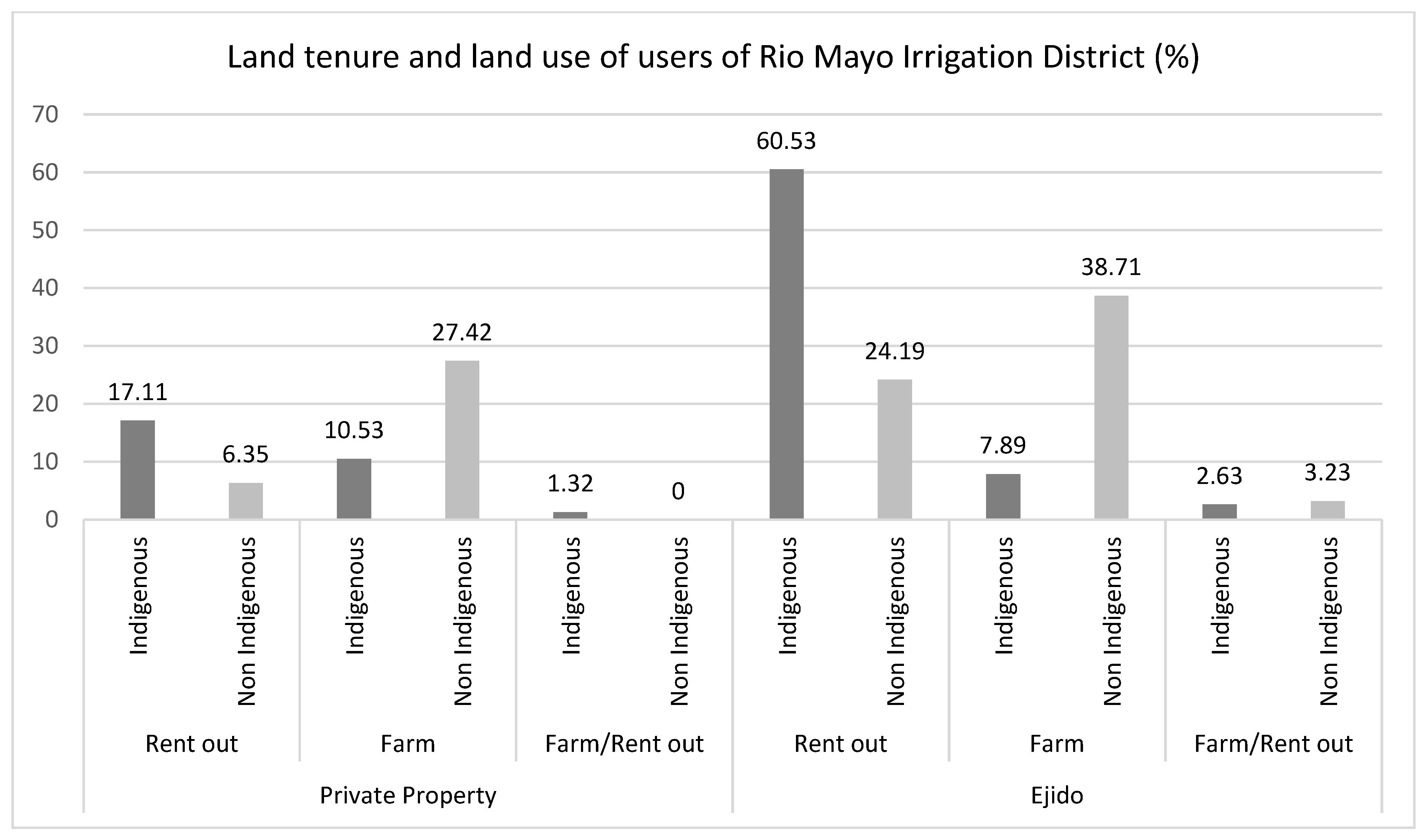
5.3. Land Tenure and Land Use in Irrigation District

Figure 2 shows that of all indigenous users interviewed, only 29% own private property; the other 71% hold ejido property. Of all indigenous users, 80% rent out their land and only 20% use it to farm. Of the indigenous ejido members, 60% rent out their land to others who farm it, and only 8% exclusively farm their land. An additional 2.63% cultivate part of their land, principally for self-consumption, and rent out another part to other farmers.
Similarly, of all non-indigenous users interviewed, only 34% own private property, while 66% hold ejido property. However, of all non-indigenous users, only 32% rent out their land, much less than the indigenous users, while the other 68% use it to farm. Of the non-indigenous ejido members, 24% rent out their land, and 39% exclusively farm it—almost five times more than the indigenous ejido members.

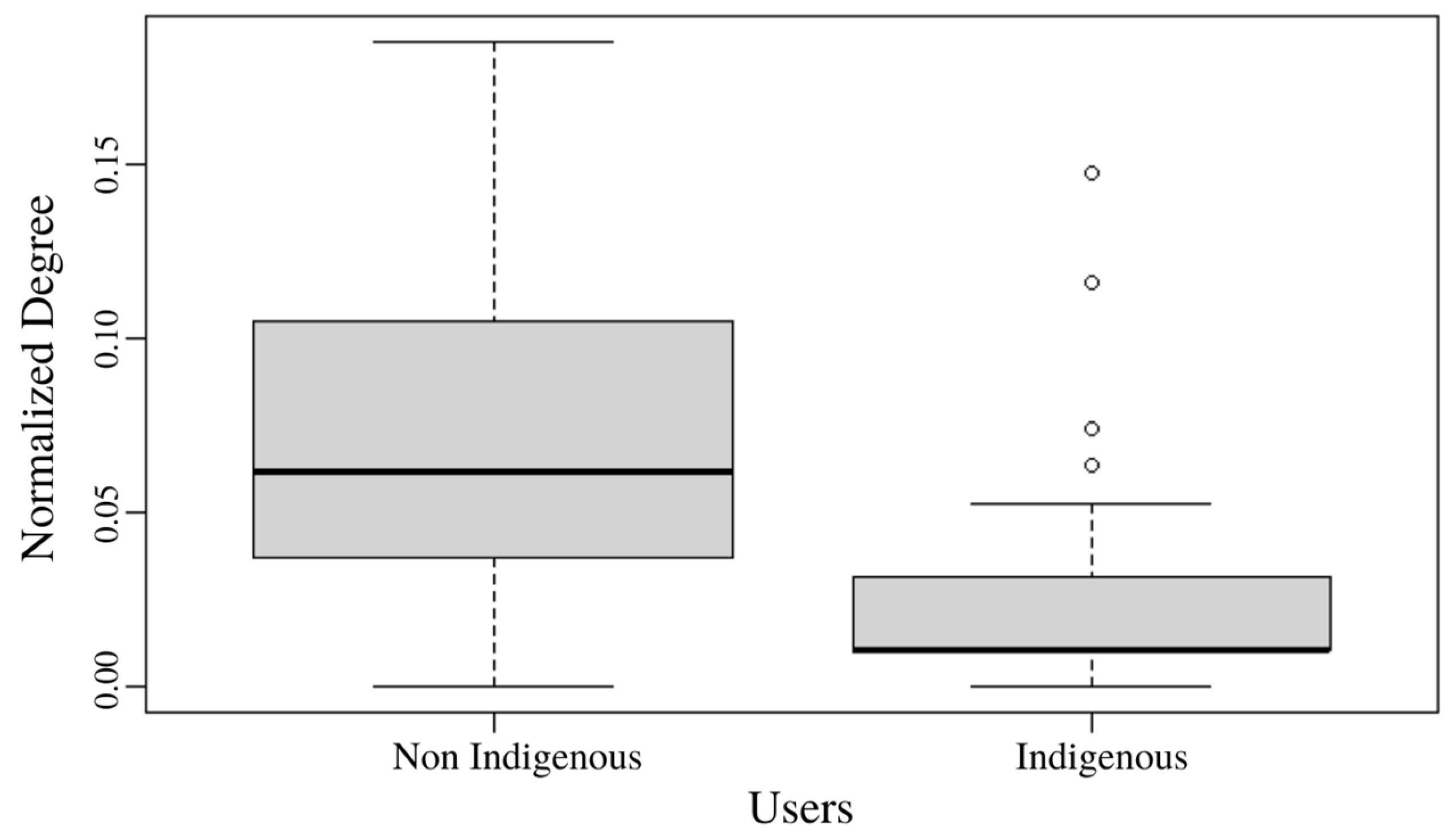
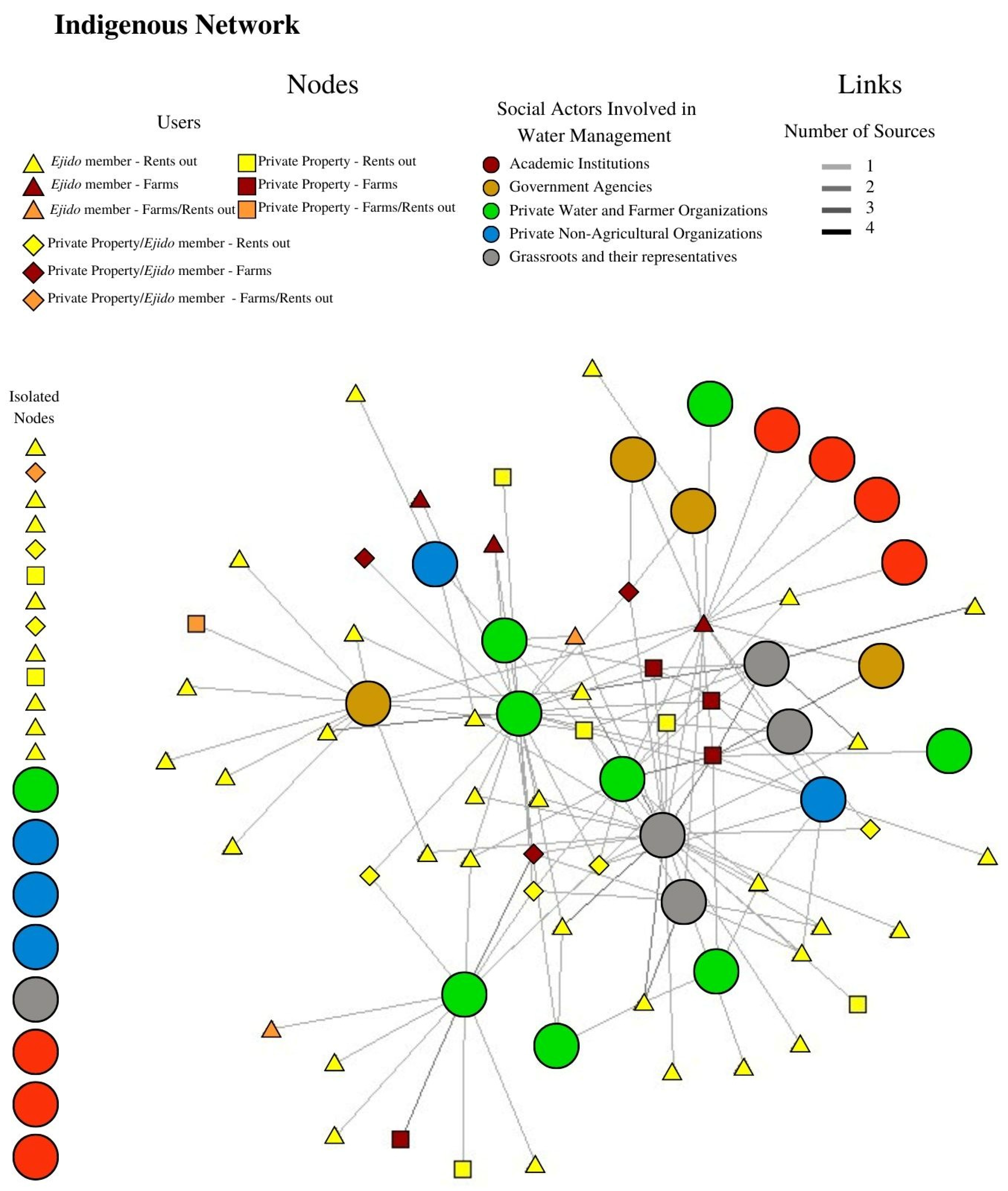
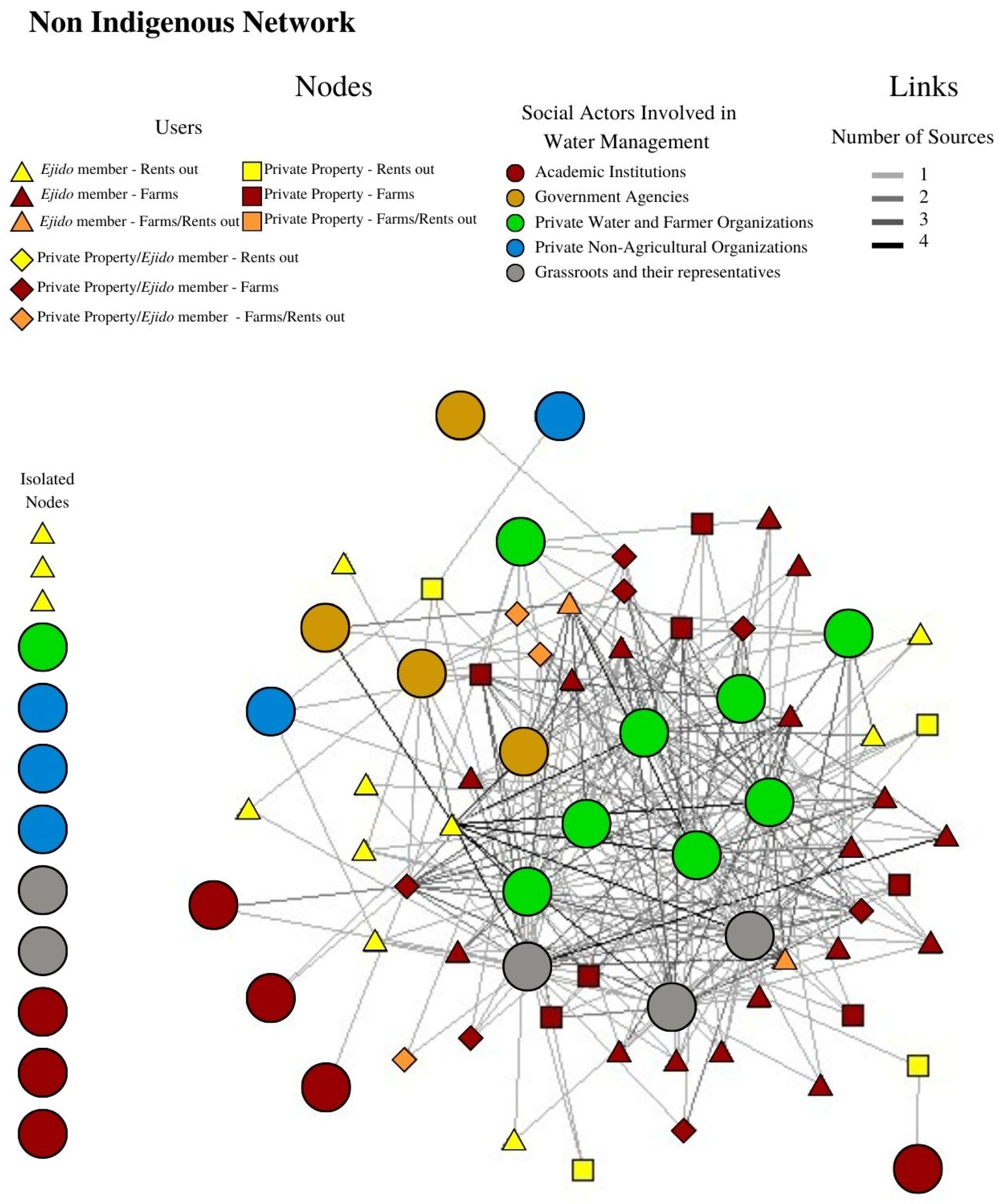
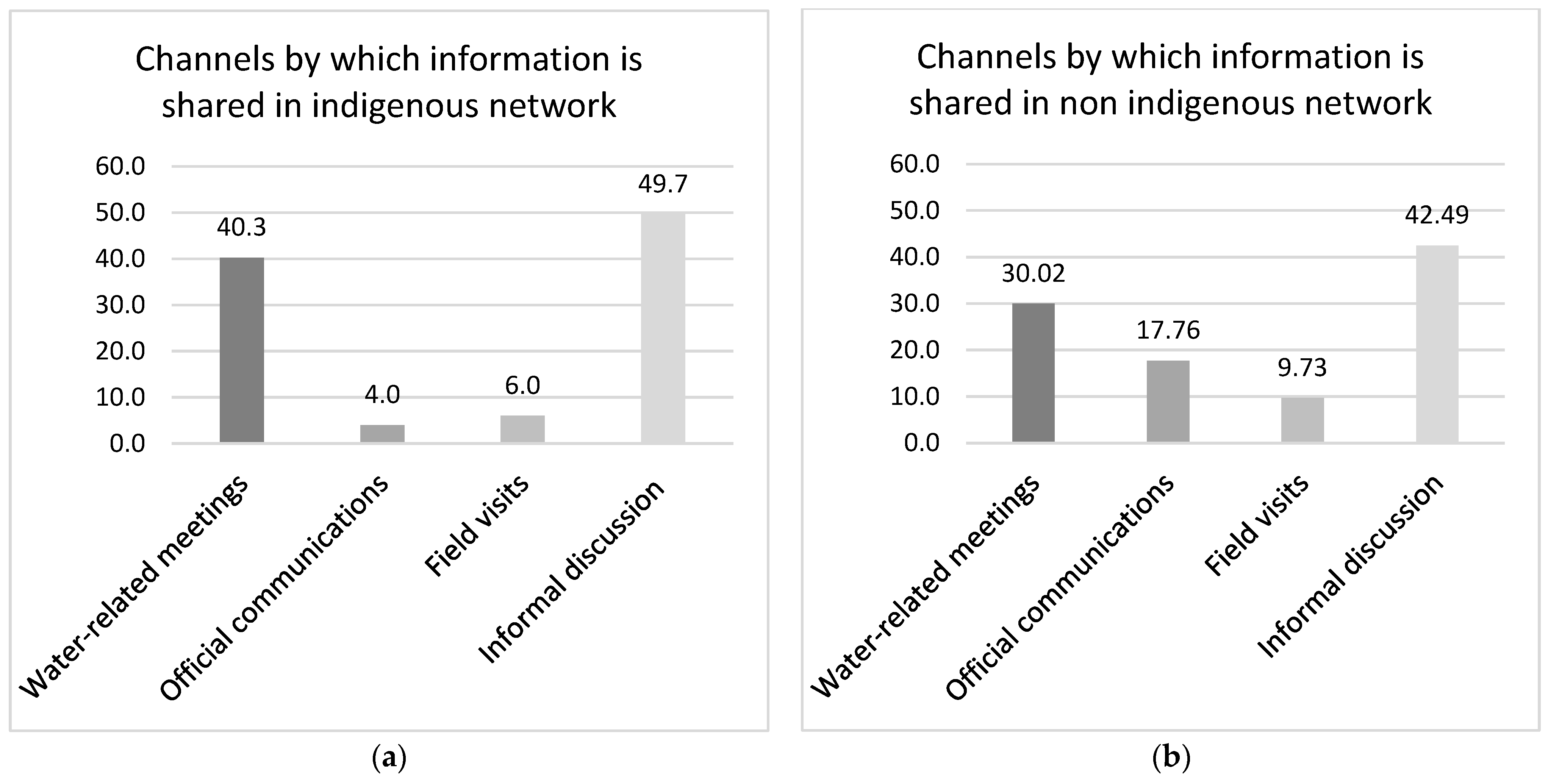
5.4. Water Management Information Networks in Rio Mayo Irrigation District

The information networks presented are bimodal, involving interaction between social actors influencing water management and Rio Mayo Irrigation District users. Users were asked, “What social actors influencing water management have shared information with you regarding use and distribution of water in the past two years?”, and “By what means was the information shared?” As a result of the responses, two networks were identified: indigenous users and non-indigenous users.
The Mann–Whitney U test for the normalized degree for the amount of water-use-related information to which indigenous and non-indigenous users as a whole had access resulted in a U = 2962.5, with a p value < 0.00 and an effect size of 0.63. The mean and standard deviation of the normalized degree for the non-indigenous users is greater than that of the indigenous users (see Figure 3). This indicates that the amount of water-use-related information received by non-indigenous users from the Rio Mayo Irrigation District is greater than that received by indigenous users.
The visualization of the water-use-related information network is presented in Figure 4 for indigenous users and Figure 5 for non-indigenous users. As explained in Section 4.2, it is a bimodal network, in which the social actors influencing water management are the first type of nodes, represented in the network as circles with their colors indicating the category to which they belong (see Appendix A). The second type of nodes are the users, represented as triangles, squares or rhombuses, depending on the type of land tenure (ejido, private property, or both, respectively). The color (yellow, red, or orange) in each shape indicates the use of the land (rents out, farms or both, respectively). Finally, the links are represented by lines and indicate the number of sources by which the water-use-related information was shared; a darker color means that the information was shared by more sources.
A notable difference exists between the two networks with respect to the amount of water-use-related information users receive. In the indigenous network, 13 users did not receive any information. By contrast, only three users of the non-indigenous network did not receive any information. Of the indigenous users, 12 rent out their plots, 8 possess ejido land, 9 speak their indigenous language, and none have studied beyond secondary school. The fact that indigenous users rent out land has led them to become apathetic about water and land use. As two isolated indigenous users mentioned: “I’ve never worked the land. I’m not interested [in knowing about water]. Why should I be?” and “I’m not interested [in knowing about water] because I don’t harvest. I just rent [out my land]”.
In both networks, social actors influencing water management that appear to be isolated in the diagram provided no information to users. Some of these are private non-agricultural organizations. Some academic institutions intermittently provided information when they were carrying out research in the region [52]. In the non-indigenous network, the Mayo government is also isolated. Furthermore, NGOs prove to be isolated, despite the fact that they have adopted the role of networking [53] (see Figure 4).
Table 2 shows the metrics of the structural analysis of both networks. The density of a network is defined as the relationship between the number of links present and the maximum number of possible links. Greater density indicates that information flows more easily. Both networks present a low density, although density of the non-indigenous network is triple that of the indigenous network. As one indigenous user mentioned, “All the information has to get to all the users; a lot doesn’t get to us”.
In social network analysis, positive key players (KPP-Pos) are nodes that have a great impact on spreading something (in this case information) among members of a network. In the present study, some of the same social actors influencing water management influenced both networks (Priv Prop Farmers, Channel worker and Ejido commissioner), although they did not carry out the same function. Meanwhile, other social actors influencing water management participated in only one of the two networks. One key player in the indigenous users’ network is the Operating Organization of Potable Water, Sewage, and Sanitation (OOMAPAS according to its Spanish initials), a municipal government agency in charge of supplying potable water for domestic use. The current Ejido Commissioner, also a key player in the indigenous network, is a user who does not speak the indigenous language and is member of the irrigation module board of directors. In the non-indigenous network, two users were identified as key players: (1) a large-scale farmer involved in international commerce—locally referred to as an “agro-titan”—who owns private property as well as ejido property and rents additional land, and has occupied political positions in the ejido as well as in the irrigation module and irrigation district; and (2) a user and channel worker of an irrigation module who is an ejido member, has postgraduate studies, and cultivates his land as well as other land that he rents.
In social network analysis, within a network, the core nodes are more connected to each other compared to the peripheral nodes, or they are connected in such a manner that allows them to control the network, while the peripheral nodes have weak connections among each other. Thus, in the present case, the core nodes control the flow of information in the network. In the indigenous network, no core nodes were identified, while in the non-indigenous network six were identified, all of which are social actors influencing water management: (1) Farmers with private property; (2) Ejido farmers; (3) Channel worker; (4) Ejido Commissioner; (5) Irrigation module representative; and (6) Ejido irrigation module representative. Thus, both types of farmers exchange more water-use-related information with non-indigenous users than with indigenous users, and the non-indigenous users have greater access to information from other sources regarding access to water than do indigenous users. The absence of core nodes in the indigenous user network indicates very weak organization with respect to water management, despite the fact that 64% of indigenous users stated that they were organized as an indigenous people with respect to water management.
Finally, Figure 6 indicates that in both networks, informal discussion among social actors influencing water management and users is the principal means of communication; 49.7% of users in the indigenous network and 42.5% of those in the non-indigenous network stated that they participated in such discussion. Nevertheless, differences were found with respect to participation in water-use-related meetings; 40.3% of those in the indigenous network stated that they participated in such meetings, compared to 30.2% of those in the non-indigenous network, and only 4% of those in the indigenous network stated that they received printed water-use-related information, compared to 17.8% of those in the non-indigenous network.

6. Discussion

Most of the studies of social network analysis of information links regarding water use have been approached from water management at the institutional level and left users aside (see for example [31,32,33,34,54,55,56]). For this reason, we refer to other social network analysis studies on environmental governance to comprehend how the structures of local networks influence access to water-use-related information, as well as to political studies.
The attributes of the users influence their access to information [57,58]. The results of this study indicate differentiated access according to whether users identify themselves as indigenous or not. According to De la Cadena and Starn [59], ethnicity is a dynamic political arena in which ethnic groups interact with other actors on different political scales based on their respective agendas, particularly with the Nation-State which largely determines the situation of these ethnic groups [60]. In the case of the Rio Mayo Irrigation District, this interaction consists of dialogue related to land tenure and land use, as historically the indigenous population’s political representation was principally based on their land tenure. However, as the indigenous inhabitants of the region no longer work the land, they have lost access to this mechanism, and their political access has been usurped by the agro-industrial producers. Furthermore, the educational disparity between the two groups accentuates their political disparity.
The political influence of the Mayo in water management of the Rio Mayo Irrigation District is minimal. As two non-indigenous users stated, “they’re just customs”, referring to the traditional Mayo government, and the traditional Mayo government “has almost nothing to do with the topic of water”. In concordance with Henry’s finding that political elite typically avoid interacting with those who do not share their system of thought [61], an almost exclusively non-indigenous political elite of the Rio Mayo Irrigation District exists that tends not to interact with indigenous users due to ideological differences. A phenomenon of homophilia occurs in which those who occupy positions in the Rio Mayo Irrigation District identify themselves as non-indigenous and tend to exchange more information with those users who—like them—are non-indigenous. In accordance with Barnes et al. [22], failing to exchange information with users who are not of the same ethnic origin may result in negative environmental consequences. The fact that 8 years ago the lower Rio Mayo within Rio Mayo Irrigation District disappeared seems to support this finding.
According to the concept of riverhood and the ontology of river-as-territory [62], for the non-indigenous elite, which has legitimized and materialized its conception of the hydrosocial territory, the water destined for the river represents an economic loss, that is, the river does not have a symbolic value. Within the identified social actors influencing water management, only grassroots organizations and their representatives, mainly the Mayo Government, share information about the symbolic value of water. The Mayo Government is found as an isolated node in the non-indigenous network, which shows that non-indigenous users maintain a vision of water as a necessary economic resource for agro-industrial production. The rest of the social actors influencing water management identified in this research are governed by a technocratic approach to water management. Therefore, there is a need for social actors who seek to promote the symbolic value of water.
In social network analysis, exclusion of access to information may be considered a negative link [24] and has significant consequences on a network level [63]. Although analysis of negative links is beyond the scope of the present study, a group of indigenous users clearly exists who speak the indigenous language, have little formal education, and rent out their ejido land, and members of this group are excluded from water-use-related information, which exacerbates the existing power asymmetries between indigenous and non-indigenous users [64].
Two types of power may be identified in the network of water-use-related information in the Rio Mayo Irrigation District, based on user position: power as access and power as control [65]. Analysis of the networks in the Rio Mayo Irrigation District indicate that the non-indigenous users have both access to and control of water-use-related information, and that they grant little or no participation in governance to the indigenous users [66,67], who are the most vulnerable and least benefited by the current management system [27]. The fact that many more non-indigenous than indigenous users are farmers (66% vs. 18%) determines power as access and control. As one indigenous user stated, “It’s the rentee (farmer) who has the contacts and information regarding use of water and land. They pay us the rent and that’s it”.
As one user who works in the irrigation module stated, information “is an element of negotiation of the people”, but in the case of the Rio Mayo Irrigation District, information exchanged is principally related to negotiation of prices of property rental. Rental prices vary depending not only on the quality and location of the property, but also on the quantity of water available. In times of water scarcity, land is rented at a lower price; thus, many users seek information regarding availability of water, and scarcity is socially and politically constructed to achieve certain objectives [68,69].
Finally, the political power of the indigenous users depends on the composition of their collective territory (the number of communal landholdings as well as their size), but above all on the proportion of non-indigenous members of these landholdings in their ejidos [6]. In the Mayo case, the exact composition of these landholdings is unknown, even to the Mayo. Nevertheless, the Mayo territory is recognized as being fragmented into at least 87 communal landholdings, most of which are ejidos principally made up of mestizos and non-indigenous migrants. This has debilitated the political force of the Mayo. As one indigenous user with ejido property mentioned, in ejido assembles “they speak more about renting out their land than about water”, indicating that power—largely defined in the Rio Mayo Irrigation District as control over water—is outside the realm of the indigenous inhabitants of the region. Therefore, it is not surprising that a Top Five Positive Key Player in the Mayo user network is OOMAPAS; indigenous users seek information on water for domestic use because it is not guaranteed to them. In some Mayo localities, the inhabitants have organized themselves to exercise their vernacular rights to water, which, although they outside the law in the operation of clandestine wells, represent mechanisms to guarantee not only their human right to water, but also a form of water sovereignty [70,71].

7. Conclusions

The Rio Mayo Irrigation District is a complex capitalist agro-industrial system. As one indigenous user stated: “We need the rich, and they need us”. Differentiation in users’ access to information according to their ethnic matrix is evident, and this differentiation is clearly associated with land tenure and land use. Upon analyzing the role of users in the networks of water-use-related information, it was found that the possibility that a Rio Mayo Irrigation District user is a farmer with access to water-use-related information varies (from greater to less) according to whether they are non-indigenous private landowners, non-indigenous ejido landholders, indigenous private landowners, or—finally—indigenous ejido landholders. Furthermore, those who speak the indigenous language have even less probability of being famers with access to water-use-related information (see Appendix B).
Within the Rio Mayo Irrigation District, the owners of capital consist of a small group of non-indigenous, predominantly private landowners and an even smaller group of ejido members, which both rent the land and the water rights. They have used a technocratic approach to legitimize their discourse as water experts and displace the cultural symbolic value that the Mayo have given their river for thousands of years. Despite the partitioning of the land to the Mayo, in 1938 and 1976, the agricultural vocation of this population has been gradually supplanted, and they have become not only hired labor for agro-capitalists, but also providers of the basic inputs for agriculture: land and water. This process has led to withdrawal by the Mayo from participation in local territorial–political matters, including in the networks of water-use-related information, which in turn has impeded their involvement in commercial agriculture as farmers, as well as maintenance of their traditional agricultural systems.
This study has indicated the existence of a relationship between access to information on the one hand and ethnicity, land tenure, and land use on the other. Social actors influencing water management share more water-use-related information with non-indigenous users and have displaced indigenous users in water management. This has caused a vicious cycle in which a small group of non-indigenous users has concentrated land and water by signing leases for principally indigenous ejido land, thereby excluding the plot owners from water-use-related information and productive processes. As non-indigenous farmer users increasingly concentrate land, they can exercise greater pressure on the social actors influencing water management to provide them with information, and thereby control water management. Meanwhile, it is unlikely that the indigenous users who rent out their land will again farm due to their lack of information regarding formal and informal processes for implementing their de facto water rights.
This underlying structure of the Rio Mayo Irrigation District has been revealed through social network analysis with a political ecology approach. As a result of national social policies, the Mayo has increased its monetary income, although not to the level of the non-indigenous. Prior to establishment of the Rio Mayo Irrigation District, agriculture in the Mayo territory was principally limited to self-subsistence cultivation on the riverbanks. As a result of the creation of the Rio Mayo Irrigation District and construction of the Mocuzari dam, the surface of industrial agriculture in the area—almost all of which is carried out on rented land—has greatly increased. Furthermore, purchase and rental of their land as well as Mayo demographic growth have led them to move to urban centers to seek other income sources. Thus, the millennial inhabitants of the Rio Mayo have lost access to irrigation water, which has affected the water available for domestic use, and has caused the Mayo to look for alternatives considered a form of resistance.
Finally, one of the limitations of this study is its cross-sectional approach; a snapshot of the information flow at a point in time is presented. Although this image can help to understand the social processes of exclusion of a group, it is susceptible to drastic modifications with the arrival of new social actors or public policies that modify the established dynamics. Another limitation is that some social actors were represented individually in the networks, while others had to be grouped for their representation (see Appendix A). Lastly, the field data were collected during green light periods during the COVID-19 pandemic, so socialization patterns of individuals could have been affected.

Author Contributions

Conceptualization, I.M.R.-N., D.L.A., A.D.M. and E.C.J.; Methodology, I.M.R.-N., D.L.A., A.D.M. and E.C.J.; Software, E.C.J.; Validation, E.C.J.; Formal Analysis, I.M.R.-N., D.L.A., A.D.M. and E.C.J.; Investigation, I.M.R.-N., D.L.A., A.D.M. and E.C.J.; Resources, I.M.R.-N., D.L.A., A.D.M. and E.C.J.; Data Curation, I.M.R.-N.; Writing—Original Draft Preparation, I.M.R.-N. and D.L.A.; Writing—Review and Editing, A.D.M. and E.C.J.; Visualization, I.M.R.-N., D.L.A., A.D.M. and E.C.J.; Supervision, D.L.A., A.D.M. and E.C.J.; Project Administration, D.L.A.; Funding Acquisition, I.M.R.-N. and D.L.A. All authors have read and agreed to the published version of the manuscript.

Funding

Research for this paper was conducted in the context of National Observatory for Socio-Ecological Sustainability (ONSSES) a CONACYT project and the research project “Hydrosocial relations of Mayo Batwe (Rio Mayo): towards an environmental justice” funded by Biophilia Foundation.

Acknowledgments

We thank the Centro de Investigación en Alimentación y Desarrollo (CIAD), Consejo Nacional de Ciencia y Tecnología (CONACYT), University of North Carolina Greensboro and University of Texas Health Science Center at Houston. The authors thank all participating stakeholders and special thanks are given to Ignacio Ruiz Love, Erasmo Leyva Yocupicio and the Rio Mayo Irrigation District for contributions to this research.

Conflicts of Interest

The authors declare no conflict of interest. The sponsors had no role in the design, execution, interpretation, or writing of the study.

Appendix A

Table A1. Social Actors involved in water management (SAIWM) in the Río Mayo Irrigation District (RMID); IM = irrigation module.
1. Government Agencies
No.AgencyRepresentativeScale of InfluencePrincipal RoleNetworks Influenced
1CONAGUA
IR (National Water Commission)
General Manager of RMIDRegionalPrograms and supervises distribution of irrigation water to each IM of RMID. One general manager exists in the irrigation district.
2SADER (Ministry of Agriculture and Rural Development)District
Chief of Rural Development
RegionalIssues phyto- and zoo-sanitary certification for crops; promotes and implements government agricultural support programs. One representative exists per county, for a total of 3.
3OOMAPAS (Local Operating Organization of Potable Water, Sewage, and Sanitation)OOMAPASLocalIn charge of water supply and sanitation for domestic and non-agricultural commercial use.
One OOMAPAS exists per county, for a total of 3.
indigenous
4CEA (State Water Commission)CEAStatePlans and executes hydraulic projects. One CEA exists in the state.
2. Private Water and Farmer Organizations
No.AbbreviationFull nameScale of influencePrincipal RoleNetworks influenced
5IM Rep Representative of Irrigation Module (IM) usersLocalElected by users to coordinate and supervise functioning of an
IM of RMID; supervises management of channel gates to send water to users. One exists per IM, for a total of 16.
non-indigenous,
indigenous
6Channel worker IM channel worker LocalEmployee of an IM of RMID who opens and closes channel gates to provide water to users. Two exist per IM, for a total of 32.non-indigenous,
indigenous
7Priv prop repRepresentative of private property owners in IMLocalRepresentative of users with private property in the IM elected to procure their interests. One exists per IM, for a total of 16.
8Farmers’ org Farmers’ organizations RegionalGroups of farmers of the same crop (potatoes, other vegetables, wheat, safflower, etc.) organized to maximize political influence so water is provided according to their crops’ needs.
9Priv Prop FarmersFarmers with private property LocalFarmers with private property who rent land and water rights. non-indigenous,
indigenous
10Priv Prop Farmers + wellFarmers with private property and well water use rightsRegionalFarmers with private property who rent out land and water rights. They own a private well and sell water to ID and other farmers.
11IntermediaryIntermediaryLocalPerson hired by landholder to obtain people to rent or purchase land and water rights.
12PackersVegetable packers RegionalBusinesses that purchase farmers’ vegetables. They influence product prices within RMID.
13Credit unions Credit unionsRegionalFinancial services that provide money for farmers to purchase inputs (including water) according to amount of land and water.
3. Non-Agricultural Businesses
No.AbbreviationDescriptionScale of influencePrincipal Role
14Fisheries Fishing businesses that pack shrimp and sardinesLocalAquicultural businesses
that use groundwater
15Water purifiersWater purification plants LocalFamily-owned businesses that purify drinking water
16Tankers Water tankersLocalTrucks that transport water to homes for domestic use in the case of water shortage; use groundwater
17ButcheriesButcheries in NavojoaRegionalMunicipal butcheries; contaminates surface water and groundwater
18BreweryCuauhtémoc Moctezuma BreweryRegionalManufactures Tecate Beer; uses large quantities of groundwater
4. Grassroots organizations and their representatives
No.AbbreviationFull nameScale of influencePrincipal RoleNetworks influenced
19Ejido CommissionerEjido CommissionerLocal Ejido member elected to be in charge of legal representation of the ejidonon-indigenous,
indigenous
20Ejido IM RepRepresentative of ejido members in the IMLocalRepresentative of users with ejido property in the IM elected to procure their interests. One exists per IM, for a total of 16non-indigenous
21Ejido membersEjido landholderLocalEjido members who farm or rent out their land and water rights non-indigenous
22Mayo governmentTraditional Mayo governmentRegionalTraditional government largely coordinating ceremonial matters; one per traditional riverside village (for 8 villages)isolated actor in
non-indigenous network
23NGONon-governmental organizationsNationalNon-governmental and business organizations which provide social and/or economic support in the regionisolated actor in
non-indigenous andindigenous networks
5. Academic Institutions
No.AcronymFull nameScale of influenceType of institution
24CIADFood and Development Research Center RegionalGovernment research center
25ITSONTechnological Institute of SonoraStateState technological institute
26UNISONUniversity of SonoraStatePublic university
27COLSONCollege of SonoraStateGovernment research center
28UNAMNational Autonomous University of MexicoNationalPublic university
29IMTAMexican Institute of Water Technology National Research institute of CONAGUA
30ITH/UTETechnological Institute of HuatabampoMunicipalPublic municipal technological institute
Note: Source: original diagram.

Appendix B

Table A2. Attributes of users of interviewees of Río Mayo Irrigation District.
AttributeIndigenous Users (n = 66)Non-Indigenous Users (n = 52)Total (n = 118)
Gender% Female37.913.527.1
% Male62.186.572.9
Age% 18–301.5 1.91.7
% 31–6036.450.042.4
% over 6062.148.155.9
Formal education initiated% Primary57.6 21.241.5
% Secondary27.3 25.026.3
% High school12.113.512.7
% University3 40.419.5
Occupation% Farmer7.6 57.729.7
% Wage laborer28.8 11.521.2
% Homemaker30.3 9.621.2
% Other 33.3 21.228.0
Family composition % Family members under age 18
056.151.954.2
115.29.612.7
213.619.216.1
312.113.512.7
4 or more35.8 4.2
% Family members over age 18
14.59.6 6.8
234.848.140.7
318.223.120.3
4 or more42.419.232.2
Ethnicity% Mayo self-identification100 N/A55.9
% Speakers of indigenous language66.7N/A37.3
% Consider Mayo people to be organized with respect to irrigation management 63.6N/A35.6
Economy% Considering that income covers basic family needs31.869.248.3
% Considering that family economic situation has improved in past 25 years 31.848.139.0
% Considering that family economic situation has remained stable in past 25 years 51.534.644.1
% Considering that family economic situation has worsened in past 25 years16.717.316.9
Total interviewees 6652118
Note: Source: original diagram.

References

  1. World Economic Forum. The Global Risks Report 2021, 16th ed.; World Economic Forum: Cologny, Switzerland, 2021. [Google Scholar]
  2. United Nations. The United Nations World Water Development Report 2021: Valuing Water; UNESCO: London, UK, 2021. [Google Scholar]
  3. CONAGUA. Programa Nacional Hídrico (PNH) 2020–2024; Comisión Nacional del Agua: Mexico City, Mexico, 2020. [Google Scholar]
  4. SINA. Distritos y Unidades de Riego (Nacional). Conagua. 2021. Available online: http://sina.conagua.gob.mx/sina/tema.php?tema=distritosriego&ver=reporte&o=1&n=nacional (accessed on 8 December 2022).
  5. Boege, E. El Patrimonio Biocultural de los Pueblos Indígenas de México; Instituto Nacional de Antropología e Historia: Mexico City, Mexico, 2008. [Google Scholar]
  6. Luque, D.; Martínez-Yrízar, A.; Montijo, A.B.; López Cruz, G.; Murphy, A. Complejos Bioculturales de Sonora Pueblos y Territorios Indígenas; Centro de Investigación en Alimentos y Desarrollo A.C.: Sonora, Mexico, 2016. [Google Scholar]
  7. Boelens, R.; Perreault, T.; Vos, J. The multiple challenges and layers of water justice struggles. In Water Justice; Boelens, R., Perreault, T., Vos, J., Eds.; University Press: Cambridge, UK, 2018; pp. 1–37. [Google Scholar] [CrossRef]
  8. Peña, F.; Duarte, B.; Yacoub, C.; Boelens, R. Agronegocios y concentración de agua en américa latina Alimentos, abundancia, desarrollo? In Agua y Ecología Política: El Extractivismo en La Agroexportación, La Minería y Las Hidroeléctricas en Latinoamérica; Yacoub, C., Duarte, B., Boelens, R., Eds.; Abya-Yala, Justicia Hídrica: El Alto, Bolivia, 2015; pp. 33–44. [Google Scholar]
  9. Vos, J.; Boelens, R. Aguas virtuales, agroexportadores y comunidades campesinas: Las trampas de la certificación de la producción sostenible. In Aguas Robadas: Despojo Hídrico y Movilización Social; Vos, J., Boelens, R., Eds.; Justicia Hídrica, IEP y Abya Yala: El Alto, Bolivia, 2013; pp. 43–64. [Google Scholar]
  10. Boelens, R.; Cremers, L.; Zwarteveen, M. Justicia hídrica: Acumulación de agua, conflictos y acción de la sociedad civil. In Justicia Hídrica: Acumulación, Conflicto y Acción Social; Boelens, R., Cremers, L., Zwarteveen, M., Eds.; Fondo Editorial PUCP, Justicia Hídrica: El Alto, Bolivia, 2011; pp. 13–26. [Google Scholar]
  11. Cárdenas-Panduro, A. Acumulación de agua subterránea por empresas agroexportadoras en el valle de Ica, Perú. In Agua y Ecología Política: El Extractivismo en La Agroexportación, La Minería y Las Hidroeléctricas en Latinoamérica; Yacoub, C., Duarte, B., Boelens, R., Eds.; Abya-Yala, Justicia Hídrica: El Alto, Bolivia, 2015; pp. 67–84. [Google Scholar]
  12. Hidalgo-Bastidas, J.P.; Boelens, R.; Isch, E. Hydroterritorial configuration and confrontation: The Daule-Peripa multipurpose hydraulic scheme in coastal Ecuador. Lat. Am. Res. Rev. 2018, 53, 517–534. [Google Scholar] [CrossRef] [Green Version]
  13. Linton, J.; Budds, J. The hydrosocial cycle: Defining and mobilizing a relational-dialectical approach to water. Geoforum 2014, 57, 170–180. [Google Scholar] [CrossRef]
  14. Erwin, A.; Ma, Z.; Popovici, R.; O’Brien, E.P.S.; Zanotti, L.; Zeballos, E.Z.; Bauchet, J.; Calderón, N.R.; Larrea, G.R.A. Intersectionality shapes adaptation to social-ecological change. World Dev. 2021, 138, 105282. [Google Scholar] [CrossRef]
  15. Zwarteveen, M. The politics of gender and identity in irrigation expert thinking. In Out of the Mainstream: Water Rights, Politics and Identity, 1st ed.; Boelens, R., Getches, D., Guevara-Gil, A., Eds.; Earthscan: London, UK; Washington, DC, USA, 2010; pp. 119–144. [Google Scholar]
  16. Robbins, P. Political Ecology: A Critical Introduction, 2nd ed.; John Wiley & Sons: Hoboken, NJ, USA, 2012. [Google Scholar]
  17. Boelens, R.; Damonte, G.; Seemann, M.; Duarte, B.; Yacoub, C. Despojo del agua en Latinoamérica: Introducción a la ecología política del agua en los agronegocios, la minería y las hidroeléctricas. In Agua y Ecología Política: El Extractivismo en La Agroexportación, La Minería y Las Hidroeléctricas en Latinoamérica; Yacoub, C., Duarte, B., Boelens, R., Eds.; Abya-Yala, Justicia Hídrica: El Alto, Bolivia, 2015; pp. 11–32. [Google Scholar]
  18. Alimonda, H.; Pérez, C.T.; Martín, F. Ecología Política Latinoamericana, 2nd ed.; CLACSO: Stockholm, Sweden, 2017. [Google Scholar]
  19. Scott, J. Social Network Analysis, 4th ed.; SAGE: Newcastle Upon Tyne, UK, 2017. [Google Scholar]
  20. Faas, A.J.; Jones, E.; Whiteford, L.; Tobin, G.; Murphy, A. Gendered access to formal and informal resources in postdisaster development in the Ecuadorian Andes. Mt. Res. Dev. 2014, 34, 223–234. [Google Scholar] [CrossRef]
  21. Jones, E.; Faas, A.J.; Murphy, A.; Tobin, G.; Whiteford, L.; McCarty, C. Cross-cultural and site-based influences on which demographic, individual well-being, and social network factors predict risk perception in hazard and disaster settings. Hum. Nat. 2013, 24, 5–32. [Google Scholar] [CrossRef] [Green Version]
  22. Barnes, M.L.; Lynham, J.; Kalberg, K.; Leung, P. Social networks and environmental outcomes. Proc. Natl. Acad. Sci. USA 2016, 113, 6466–6471. [Google Scholar] [CrossRef] [Green Version]
  23. Crona, B.; Hubacek, K. The right connections: How do social networks lubricate the machinery of natural resource governance? Ecol. Soc. 2010, 15, 18. [Google Scholar] [CrossRef] [Green Version]
  24. Bodin, Ö.; García, M.M.; Robins, G. Reconciling conflict and cooperation in environmental governance: A social network perspective. Annu. Rev. Environ. Resour. 2020, 45, 471–495. [Google Scholar] [CrossRef] [Green Version]
  25. Newig, J.; Günther, D.; Pahl-Wostl, C. Synapses in the network: Learning in governance networks in the context of environmental management. Ecol. Soc. 2010, 15, 24. [Google Scholar] [CrossRef]
  26. Schröter, B.; Hauck, J.; Hackenberg, I.; Matzdorf, B. Bringing transparency into the process: Social network analysis as a tool to support the participatory design and implementation process of payments for ecosystem services. Ecosyst. Serv. 2018, 34, 206–217. [Google Scholar] [CrossRef]
  27. Birkenholtz, T. Network political ecology: Method and theory in climate change vulnerability and adaptation research. Prog. Hum. Geogr. 2011, 36, 295–315. [Google Scholar] [CrossRef] [Green Version]
  28. Vos, C.; Hubacek, K.; Reed, M. Articles stakeholder analysis and social network analysis in natural resource management. Soc. Nat. Resour. 2009, 22, 501–518. [Google Scholar] [CrossRef]
  29. Lange, E.; Milner-Gulland, E.J.; Keane, A. Improving environmental interventions by understanding information flows. Trends Ecol. Evol. 2019, 34, 1034–1047. [Google Scholar] [CrossRef] [PubMed] [Green Version]
  30. Fischer, M.; Ingold, K.; Ivanova, S. Information exchange under uncertainty: The case of unconventional gas development in the United Kingdom. Land Use Policy 2017, 67, 200–211. [Google Scholar] [CrossRef]
  31. Herzog, L.M.; Ingold, K. Threats to common-pool resources and the importance of forums: On the emergence of cooperation in CPR problem settings. Policy Stud. J. 2019, 47, 77–113. [Google Scholar] [CrossRef]
  32. Simpson, H.C.; de Loë, R.C. The agricultural community as a social network in a collaborative, multi-stakeholder problem-solving process. Water 2017, 9, 750. [Google Scholar] [CrossRef] [Green Version]
  33. Rojas, R.; Bennison, G.; Gálvez, V.; Claro, E.; Castelblanco, G. Advancing collaborative water governance: Unravelling stakeholders’ relationships and influences in Contentious river basins. Water 2020, 12, 3316. [Google Scholar] [CrossRef]
  34. Breuer, A.; Oswald Spring, U. The 2030 agenda as agenda setting event for water governance? Evidence from the Cuautla river basin in Morelos and Mexico. Water 2020, 12, 314. [Google Scholar] [CrossRef] [Green Version]
  35. Haro-Encinas, J.A.; Martínez-Coria, R. Patrimonio Biocultural y Despojo Territorial en el Río Mayo: Los Guarijíos de Sonora y el Proyecto de Presa Los Pilares—Bicentenario; El Colegio de Sonora: Hermosillo, Mexico, 2019. [Google Scholar]
  36. Murphy, A.D.; Luque, D.; Martínez-Yrízar, A.; Búrquez, A. The struggle of indigenous people of the lower Rio Mayo, northwestern Mexico for water resources: An overview and a critical assessment. J. Ecol. Anthropol. 2022, 23, 32–41. Available online: https://digitalcommons.usf.edu/jea/vol23/iss1/2 (accessed on 13 January 2023).
  37. Banister, J.M. Deluges of grandeur: Water, territory, and power on northwest Mexico’s Río Mayo, 1880–1910. Water Altern. 2011, 4, 35–53. [Google Scholar]
  38. Lorenzana, G.D. La gran hidráulica en los ríos Yaqui y Mayo, Sonora 1936–1957. Anu. Estud. Am. 2019, 76, 715–747. [Google Scholar] [CrossRef]
  39. Günther, G.M. Política hídrica federal en México: Un análisis desde su evolución y arquitectura institucional. In La Política del Ambiente en América Latina; Günther, G.M., Gutiérrez, R.A., Eds.; CLACSO: Stockholm, Sweden, 2017; pp. 127–158. [Google Scholar]
  40. Wilder, M. Water governance in Mexico: Political and economic apertures and a shifting state-citizen relationship. Ecol. Soc. 2010, 15, 22. [Google Scholar] [CrossRef]
  41. Wilder, M.; Lankao, P.R. Paradoxes of decentralization: Water reform and social implications in Mexico. World Dev. 2006, 34, 1977–1995. [Google Scholar] [CrossRef] [Green Version]
  42. Hearne, R.R. Evolving water management institutions in Mexico. Water Resour. Res. 2004, 40, 1–11. [Google Scholar] [CrossRef]
  43. Bernard, H.R. Research Methods in Anthropology. Qualitative and Quantitative Approaches, 6th ed.; Rowman & Littlefield: Lanham, MD, USA, 2017. [Google Scholar]
  44. Valles, M.S. Técnicas Cualitativas de Investigación Social; Editorial Síntesis S.A.: Madrid, Spain, 1999. [Google Scholar]
  45. Glaser, B.; Strauss, A. The Discovery of Grounded Theory. Strategies for Qualitative Research; Aldine: Manchester, UK, 1967. [Google Scholar]
  46. CEPAL. Censos 2010 y La Inclusión del Enfoque Étnico: Hacia Una Construcción Participativa Con Pueblos Indígenas y Afrodescendientes de América Latina; CEPAL: Santiago, Chile, 2009. [Google Scholar]
  47. OIT. CONVENIO No. 169. Sobre Pueblos Indígenas y Tribales en Países Independientes; OIT: Geneve, Switzerland, 1989. [Google Scholar]
  48. MDLogix. VisuaLyzer 2.2 User Manual; Medical Decision Logic Inc.: Baltimore, MD, USA, 2014. [Google Scholar]
  49. Mann, H.; Whitney, D. On a test of whether one of two random variables is stochastically larger than the other. Ann. Math. Stat. 1947, 18, 50–60. [Google Scholar] [CrossRef]
  50. Borgatti, S.P.; Everett, M.G. Network analysis of 2-mode data. Soc. Netw. 1997, 19, 243–269. [Google Scholar] [CrossRef]
  51. Agar, M. We have met the other and we’re all nonlinear: Ethnography as a nonlinear dynamic system. Complexity 2004, 10, 16–24. [Google Scholar] [CrossRef]
  52. Blacketer, M.P.; Brownlee, M.T.J.; Bowen, B.B. Perceptions of social network influence: Key player’s insights into power, conflict, and collaboration at the Bonneville Salt Flats. Environ. Manag. 2022, 69, 288–304. [Google Scholar] [CrossRef]
  53. Rathwell, K.J.; Peterson, G.D. Connecting social networks with ecosystem services for watershed governance: A social-ecological network perspective highlights the critical role of bridging organizations. Ecol. Soc. 2012, 17, 24. [Google Scholar] [CrossRef]
  54. Bitterman, P.; Koliba, C.; Singer, A. A network perspective on multi-scale water governance in the Lake Champlain Basin, Vermont. Ecol. Soc. 2023, 28, 44. [Google Scholar] [CrossRef]
  55. Muñoz-Erickson, T.A.; Cutts, B.B.; Larson, E.K.; Darby, K.J.; Neff, M.; Wutich, A.; Bolin, B. Spanning boundaries in an Arizona watershed partnership: Information networks as tools for entrenchment or ties for collaboration? Ecol. Soc. 2010, 15, 22. [Google Scholar] [CrossRef]
  56. Nabiafjadi, S.; Sharifzadeh, M.; Ahmadvand, M. Social network analysis for identifying actors engaged in water governance: An endorheic basin case in the Middle East. J. Environ. Manag. 2021, 288, 112376. [Google Scholar] [CrossRef]
  57. Crona, B.; Bodin, Ö. What you know is who you know? Communication patterns among resource users as a prerequisite for co-management. Ecol. Soc. 2006, 11, 7. [Google Scholar] [CrossRef] [Green Version]
  58. Frija, A.; Zaatra, A.; Frija, I.; AbdelHafidh, H. Mapping social networks for performance evaluation of irrigation water management in dry areas. Environ. Model. Assess. 2016, 22, 147–158. [Google Scholar] [CrossRef]
  59. De la Cadena, M.; Starn, O. Introducción. In Indigeneidades Contemporáneas: Cultura, Política y Globalización; De la Cadena, M., Starn, O., Eds.; Institut Français D’études Andines, Instituto de Estudios Peruanos: Lima, Peru, 2010; pp. 5–30. [Google Scholar] [CrossRef]
  60. Tsing, A. Identidades indígenas, nuevas y antiguas voces indígenas. In Indigeneidades Contemporáneas: Cultura, Política y Globalización; De la Cadena, M., Starn, O., Eds.; Institut Français D’études Andines, Instituto de Estudios Peruanos: Lima, Peru, 2010; pp. 32–60. [Google Scholar] [CrossRef]
  61. Henry, A.D. Ideology, power, and the structure of policy networks. Policy Stud. J. 2011, 39, 361–383. [Google Scholar] [CrossRef]
  62. Boelens, R.; Escobar, A.; Bakker, K.; Hommes, L.; Hogenboom, B.; Huijbens, E.H.; Jackson, S.; Vos, J.; Harris, L.M.; Joy, K.J.; et al. Riverhood: Political ecologies of socionature commoning and translocal struggles for water justice. J. Peasant. Stud. 2022, 1–32. [Google Scholar] [CrossRef]
  63. Sparrowe, R.; Liden, R.; Wayne, S.; Kraimer, M. Social networks and the performance of individuals and groups. Acad. Manag. J. 2001, 44, 316–325. [Google Scholar] [CrossRef]
  64. Usón, T.J.; Henríquez, C.; Dame, J. Disputed water: Competing knowledge and power asymmetries in the Yali Alto basin, Chile. Geoforum 2017, 85, 247–258. [Google Scholar] [CrossRef]
  65. Cook, K.; Emerson, R.; Gillmore, M. The distribution of power in exchange networks: Theory and experimental results. Am. J. Sociol. 1983, 89, 275–305. [Google Scholar] [CrossRef] [Green Version]
  66. Gatt, K. Social network analysis as a tool for improved water governance in Malta. Int. J. Soc. Syst. Sci. 2016, 8, 131–154. [Google Scholar] [CrossRef]
  67. Ingold, K. How to create and preserve social capital in climate adaptation policies: A network approach. Ecol. Econ. 2017, 131, 414–424. [Google Scholar] [CrossRef]
  68. Mejta, L. Whose scarcity? Whose property? The case of water in western India. Land Use Policy 2007, 24, 654–663. [Google Scholar] [CrossRef]
  69. Workman, C.L. Ebbs and flows of authority: Decentralization, development and the hydrosocial cycle in Lesotho. Water 2019, 11, 184. [Google Scholar] [CrossRef] [Green Version]
  70. Meehan, K. Water rights and wrongs: Illegality and informal use in Mexico and the U.S. In The Right to Water: Politics, Governance and Social Struggles; Sultana, F., Loftus, A., Eds.; Routledge: Oxfordshire, UK, 2013; pp. 159–173. [Google Scholar]
  71. Clark, C. The centrality of community participation to the realization of the right to water: The illustrative case of South Africa. In The Right to Water: Politics, Governance and Social Struggles; Sultana, F., Loftus, A., Eds.; Routledge: Oxfordshire, UK, 2013; pp. 174–189. [Google Scholar]
Figure 1. Río Mayo Irrigation District, Sonora, Mexico. Source: [6].
Water 15 02288 g001
Figure 2. Land tenure and land use of users of Rio Mayo Irrigation District, Sonora, Mexico according to ethnicity. Rent out = rent their land to others who farm it; Farm = farm their own land. Source: original diagram.
Water 15 02288 g002
Figure 3. Boxplot of the normalized degree of the amount of water-use-related information to which the indigenous and non-indigenous users of the Irrigation District, Sonora, Mexico had access. Source: original diagram.
Water 15 02288 g003
Figure 4. Social networks of information regarding water management for indigenous users of the Irrigation District, Sonora, Mexico. Rents out = rents their land to others who farm it; Farms = farms their own land. Source: original diagram.
Water 15 02288 g004
Figure 5. Social networks of information regarding water management for non-indigenous users of the Irrigation District, Sonora, Mexico. Rents out = rents their land to others who farm it; Farms = farms their own land. Source: original diagram.
Water 15 02288 g005
Figure 6. Channels by which information is shared within networks of the Irrigation District, Sonora, Mexico; (a) indigenous users; (b) non-indigenous users. Source: original diagram.
Water 15 02288 g006
Table 1. Description and contextual interpretation of network metrics used for social network analysis regarding water-use-related information in the Rio Mayo Irrigation District, Sonora, Mexico. SAIWM = social actors influencing water management.
MetricDescriptionInterpretation in the Study Context
Normalized degreeCalculated by dividing the number of links that each node has by the maximum number of links that that node may haveThis metric was only calculated for the users. This is the number of water-use-related information links that each user has by the maximum number of water-use-related information links that that user may have.
Total nodes (SAIWM/users)Total nodes in network Number of SAIWM and users in the network.
Isolated nodes (SAIWM/users)Total isolated nodes in networkNumber of SAIWM and users not linked to water-use-related information flow.
Total linksTotal links among all relationships in
network
Quantity of water-use-related information shared between SAIWM and users.
DensityRelationship between total current links and maximum links possible (maximum links divided by current links)Greater density indicates a network in which information flows more easily.
Degree of CentralizationDegree of centralization of the network measures to what point a network has a single actor (or several actors) with high centrality (or influence); expressed as a percentage.A high value indicates that one or few SAIWM/users are in charge of information flow.
Top 5 Positive Key Players (KPP-Pos)Key players are nodes with great impact on spreading something (in this case. information) in a network. Positive key players (KPP-Pos) are nodes that maintain the network united to its maximum level.Users and SAIWM that maintain flow of information regarding water (KPP-Pos).
Core and Peripheral nodesCore nodes are more connected among each other than with other nodes, while peripheral nodes have weak connections among each other and with other nodes.Core nodes control information flow.
Note: Source: original diagram; description of metrics was obtained from the Visualyzer 2.2 software manual [45].
Table 2. Structural analysis of information networks of indigenous and non-indigenous users of the Irrigation District, Sonora, Mexico; SAIWM = social actors influencing water management; IM = irrigation module. See Appendix A for additional abbreviations and definitions.
MetricIndigenous NetworkNon-Indigenous Network
Total nodesSAIWM = 30SAIWM = 30
Users = 66Users = 52
Total = 96Total = 82
Isolated nodesSAIWM = 8SAIWM = 9
Users = 13Users = 3
Total = 21Total = 12
Total links134298
Density0.02940.0897
Degree Centralization97.78%90.24%
Top 5 Positive Key Players (KPP-Pos)(1) Priv Prop Farmers(1) Priv Prop Farmers
(2) Channel worker (2) Channel worker
(3) Ejido Commissioner (3) Ejido commissioner
(4) PAS(4) User—channel worker
(5) User—Ejido Commissioner(5) User—“agro-titan”
Core and PeripheryNo core nodes present; all are peripheralCore nodes:
(1) Priv Prop Farmers
(2) Ejido farmer
(3) Channel worker
(4) Ejido commissioner
(5) IM Representative
(6) Ejido IM rep
Note: Source: original table.
Disclaimer/Publisher’s Note: The statements, opinions and data contained in all publications are solely those of the individual author(s) and contributor(s) and not of MDPI and/or the editor(s). MDPI and/or the editor(s) disclaim responsibility for any injury to people or property resulting from any ideas, methods, instructions or products referred to in the content.

