1. Introduction
Extreme droughts and almost total reliance on surface water have led to major cities almost running out of water, e.g., São Paulo in 2015 and Cape Town in 2018, highlighting the need to diversify water supplies and manage surface water and groundwater conjunctively to build resilience into water resource systems [
1]. A similar emergency occurred in the Algarve region, Portugal, during the drought of 2004–2005 where only the rapid recommissioning of former municipal boreholes and drilling of new boreholes prevented urban water supply failures [
2,
3]. Further recent droughts are causing increasing concern due to the lack of resilience in the water supply system.
Total water use in the Algarve is estimated to be around 237 Mm
3/yr, of which 50% is supplied by surface water from several large reservoirs, which feed a multimunicipal supply system as well as surface-water-fed irrigation perimeters [
4]. Groundwater is used extensively for irrigation of citrus, avocado and greenhouse crops. The Algarve has experienced severe droughts in recent years (2019–2022) with certain reservoirs having supplies restricted and/or approaching their dead storage [
5] and declining groundwater levels increasing the risk of seawater intrusion in some aquifers [
6,
7]. Similarly, declining groundwater storage has been identified through global studies of total water storage decline in parts of northeast China, northern India, northeast South America, southwest and south-central United States, eastern Europe and Iran [
1].
This situation is far from sustainable, with recent studies identifying that groundwater abstraction rates need to reduce by at least 70% in the Vale do Lobo sector of the Campina de Faro aquifer to prevent seawater intrusion [
8]. It is estimated that similar reductions are needed regionally to achieve sustainability of water use, with an associated 30% decrease in crop yields [
9]. These concerns led to the development of the Regional Water Efficiency Plan (RWEP) [
4], which identified a range of measures to control demand and increase security of supplies.
Managed aquifer recharge (MAR) refers to a suite of methods that are increasingly being used to maintain, enhance and secure groundwater systems under stress [
10] by making use of the vastly larger water storage volume available underground compared to that provided by surface water storage in dams and lakes, which is estimated to be two orders of magnitude smaller globally [
10]. MAR can bridge the gap between water availability during winter and irrigation during the summer months or be used to build up a strategic water resource only for use during drought years. A UNESCO collection of MAR case studies identified that MAR increases the security of water supplies, enhances ecosystems and can be achieved at less than half the cost of conventional alternatives [
11].
However, uptake of MAR is low and, while increasing at a rate of 5% per year, is not keeping up with increasing groundwater extraction [
10]; furthermore, MAR is recharging only approximately 1% of global groundwater extraction. This appears to be related to the technical challenges of MAR, the risks to aquifer water quality from the recharge water and, in many countries, the lack of specific regulations to permit and manage MAR facilities [
12,
13].
In southern Europe, often the only suitable source of water for MAR is from ephemeral rivers, as larger rivers are already dammed for water supply. Treated wastewater is a potential source, but owing to the EU Groundwater Directive, significant further treatment is usually required prior to recharge, making this an expensive and less favoured option, particularly in Portugal where regulations already exist for the direct reuse of treated wastewater for nonpotable uses [
14]. The RWEP largely excluded MAR, due to a lack of guidance for implementation and appetite (at the time) from the national environmental regulator; however, a recent government resolution now provides support for MAR as a measure to combat drought and water scarcity, providing that environmental risks can be managed appropriately (Resolução da Assembleia da República 86/2022).
Suitability for MAR is typically assessed spatially using multicriteria decision analysis (MCDA) methods, of which 63 such studies were reviewed [
15]. These studies focus on constraint and suitability mapping and provide a reasonable method of comparing potential sites at an aquifer scale. However, it is noted that without a specific purpose or applicant in mind, these maps are often published with the best intentions but perish thereafter [
15].
MCDA methods lack quantitative assessments of recharge (injection of infiltration) capacity and thus do not inform MAR design. Quantitative assessments can be based on the Theis equation [
16,
17] to estimate groundwater level rise at an injection borehole site, or the Glover method to estimate groundwater level rise beneath an infiltration basin [
18], but they typically suffer from lack of aquifer property information leading to interpolation over large areas. Site-specific methods to confirm MAR suitability and determine the fate of the recharge water usually require numerical modelling, e.g., [
19,
20,
21].
Hydrological studies are usually required to estimate the water available for MAR (WAFM) from natural streams/rivers, based on rainfall-runoff modelling and flow routing. Published works on the subject are limited to studies in the USA [
22,
23,
24,
25], of which only [
23] considers climate scenarios when estimating WAFM for flood-MAR.
Neither of these quantitative approaches link the WAFM with the aquifer capacity for MAR while also considering the water demand and the potential MAR objectives; such studies are usually site-specific. However, to assess the potential for MAR on a regional scale, all these aspects need to be considered.
We present a regional study that quantifies WAFM from ephemeral rivers under recent baseline conditions and climate change scenarios and assesses the capacity of the adjacent aquifer(s) to accept and store this water. Climate change was assessed with an ensemble of models from the EURO-CORDEX project, using RCP4.5 and RCP8.5 scenarios. We identify MAR potential for water resource zones where deficits in the supply–demand balance exist or where environmental objectives are not being met, therefore there is clear practical relevance for this study. We develop MAR options in sufficient detail to allow their comparison with the measures proposed in the RWEP in terms of their water resource benefits and preliminary costs to support integrated water resource management (IWRM) decisions in the region.
The main contribution of this work is a study that demonstrates a method to quantify the potential for MAR recharge using water from ephemeral rivers, including an assessment of predictive uncertainty and the impact of climate change. This study has wider applicability to other water-scarce regions where water resource options are limited, surface water flow is sporadic and MAR is being considered as a water resource option.
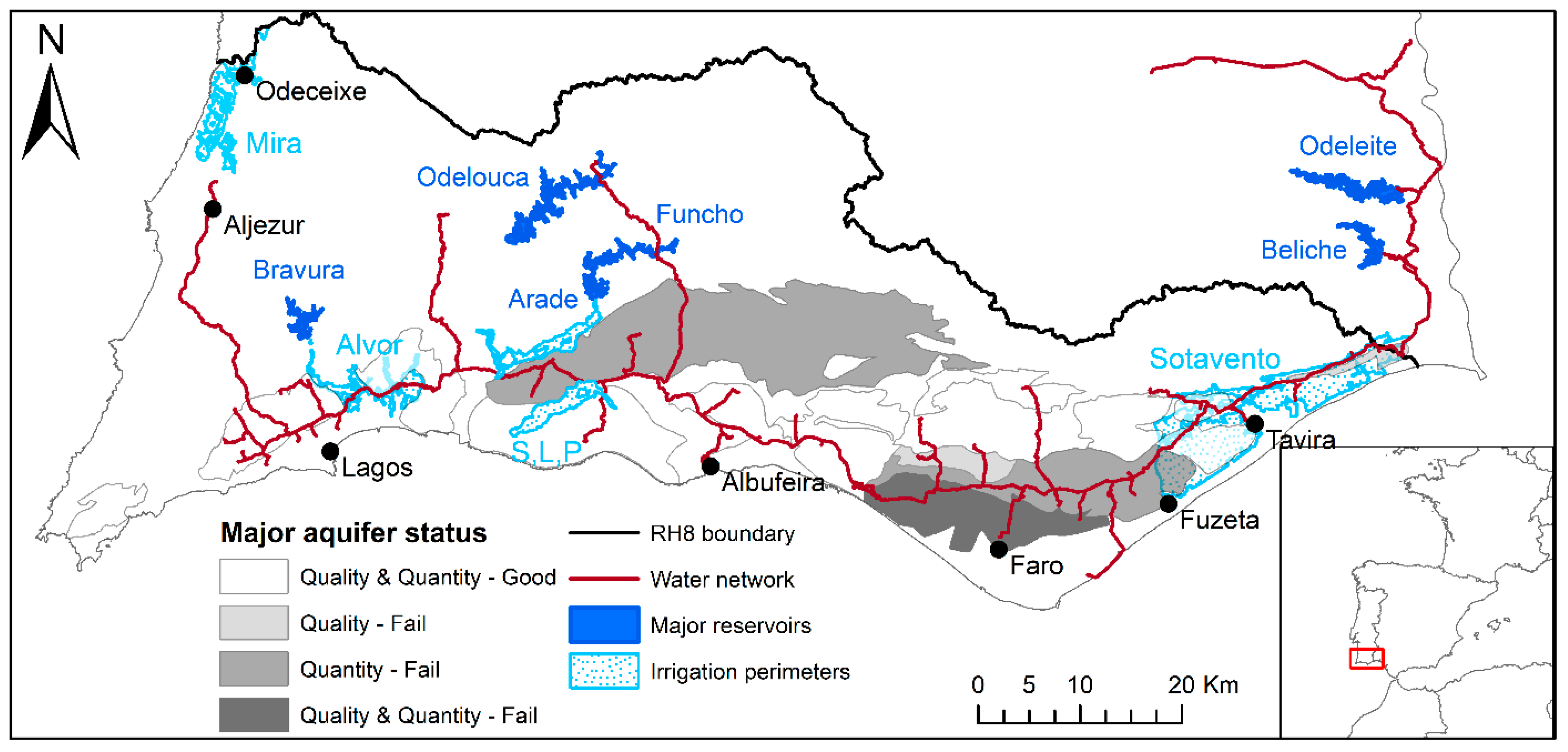
1.1. Study Area
The study area is defined as the Portuguese River Basin District RH8, the Rivers of the Algarve Region, as defined in the River Basin Management Plans (RBMP) [
26] and shown in
Figure 1.
Long-term average rainfall is 628 mm/yr and potential evapotranspiration almost doubles this at 1210 mm/yr [
26]. The future climate for the Algarve region based on the EURO-CORDEX Regional Climate Models and RCP8.5 scenario predicts annual rainfall to decrease by >20%, mostly during the spring, summer and autumn periods, with a 30% reduction in wet days [
27]. However, relative precipitation changes at the 95th and 99th percentiles indicate an increase of 10–20% and 20–70%, respectively, indicating an increase in extreme, high-intensity events. Over the same period and scenario, the change anomaly for temperature is almost 3.5 °C, with an associated increase in potential evapotranspiration of 150 mm/yr [
28].
Urban water supply is almost entirely derived from a multimunicipal system fed by several large surface water reservoirs shown in
Figure 1. Most water for agricultural use is supplied by groundwater from the major aquifers also shown in
Figure 1, apart from the four public irrigation perimeters supplied by surface water from Bravura (Alvor), Arade (Silves, Lagoa e Portimão), Odeleite-Beliche (Sotavento) and the Santa Clara dam in Alentejo (Mira in RH8) also shown in
Figure 1.
The major aquifers of the coastal Algarve region were formed during two phases of extension of a meso-Cenozoic basin, forming aquifers that include karstic and fractured limestones of the Jurassic age, permeable limestone units of the Lower Cretaceous, sandy limestones of the Miocene age and sands and gravels of the Plio-Quaternary age. These form multilayer aquifers both within and across units, separated by lower permeability weathered clays and silts. Along the coast, the connectivity between the aquifer units is often disconnected by a series of faults perpendicular to the coast, forming several relatively small aquifers (12 to 117 km
2) with similar hydro-stratigraphy [
29]. To the north of the sedimentary basin limit, hard rocks (schists and greywackes) with low permeability are found, generating the river flows captured by the major reservoirs.
Surface water storage capacity has been developed progressively with the addition of new reservoirs since the 1960s, but these have recently come under stress, approaching their dead storage and failing to meet supply commitments, particularly to the irrigation perimeters [
4]. Furthermore, assessments of the aquifer water balance identified 5 of the 25 aquifers are failing to meet “good” quantitative status as defined by the Water Framework Directive due to over-abstraction, with a further 11 exhibiting declining trends in groundwater levels indicating a wider problem of water availability vs. current groundwater use [
26]. Five aquifers also fail to meet “good” quality status due to agricultural pollutants or seawater intrusion (
Figure 1).
Recognising this, the RWEP identified 57 supply increase/addition/augmentation or demand reduction measures, costing almost EUR 200 million to achieve a water resource benefit of 33 Mm
3/yr at an average cost of EUR 6/m
3/yr [
4]. The only new source of water considered in the plan is the reuse of treated wastewater for nonpotable uses (irrigation in agriculture and green spaces). Other than this, short-term measures are focused on water efficiency/demand management measures. Longer-term measures now being considered include the first desalination plant for public supply in the Algarve and preliminary studies into regional abstraction and transfer of water from the Rio Guadiana into existing reservoirs. These longer-term schemes have significant environmental, social and potentially political consequences.
There are many uncertainties in the estimate of current water use (237 Mm
3/yr), particularly given the difficulties in measuring groundwater use, and even greater uncertainty in future demand, which was not explicitly considered in the RWEP and depends on both population and land use changes. Population projections indicate an 18% increase between 2018 and 2080 [
30], to around 520,000 people, which alone could result in an additional 4.5 Mm
3/yr demand based on water use of 150 L per person per day.
Four sources of water are potentially available for MAR in the Algarve: ephemeral river flow from catchments not already containing large dams (1), capture of reservoir planned/emergency releases (2), re-use of urban treated wastewater (3) and capture of rainfall-runoff from greenhouses (4). However, only ephemeral river flows were considered further as a suitable potential source of water for MAR. Treated wastewater is ruled out as it cannot meet the water quality thresholds of the Groundwater Directive (2006/118/EC) without significant (and expensive) treatment requirements. Reservoir releases have not occurred in the previous 20 years [
5] and are considered unlikely in future and, while capture of rainfall-runoff from greenhouses could be locally important in the Campina de Faro aquifer [
31], wider regional potential is limited.
In national legislation (Decreto-Lei No 77/2006), MAR is recognised as a potential measure to achieve status improvement under the WFD, although it is assumed that the Groundwater Directive (2006/118/EC) must be respected. In addition, while Article 62 of the Water Law (Decreto-Lei 58/2005) indicates that MAR requires a licence, there are no Portuguese or EU-wide guidelines or standards on MAR and therefore no current pathway to obtain a licence. This impasse effectively prevents MAR except for limited academic pilot trials such as those undertaken in the Rio Seco [
32]. This situation has meant that MAR has not been considered seriously as a water resource option in the Algarve until recently. This situation is now changing, with the recent passing of a resolution (No. 86/2022) recommending that the Government encourage the development of projects and initiatives that contribute to artificial recharge operations as a complementary solution for water resources management in the face of worsening drought scenarios, duly assessing and safeguarding all environmental impacts.
1.2. Rationale
The objective of this work is to identify how and where MAR can be undertaken within the Algarve region, respecting the current legislation and allowing MAR to be compared to options identified in the RWEP. Four main aspects are included:
Quantifying the water available for MAR under recent baseline conditions and under climate change;
Assessing the source water quality;
Identifying the objectives of and need for MAR; and
Estimating the aquifer capacity for MAR.
Based on the results of these, a preliminary design of MAR schemes was undertaken to quantify the potential benefit of MAR for regional water resources. Finally, the MAR options are compared to water resource options already documented or under consideration in terms of costs and benefits.
3. Results
3.1. Catchments, Aquifers and MAR Objectives
Potential catchments for MAR are shown along with the potential receiving aquifers in
Figure 3.
Catchment areas up-gradient of aquifers range in size from 32 to 433 km2. Of the 11 catchments, 7 are <100 km2, with larger catchments identified in the northwest of RH8 (Catchment Ref. 13: 250 km2) and the 2 catchments (Catchment Refs. 5 and 6) draining the Querença-Silves aquifer (total 567 km2).
All the aquifers identified are those defined in the RBMP, except for the sands, sandstones and gravels of the coast of the Baixo Alentejo (BA). These Pleistocene-age sediments occur south of Odeceixe in a shallow basin overlying an impermeable basement. Where these occur further to the north in the areas surrounding Cavaleiro and Almograve, south of the River Mira, they form an unconfined aquifer rarely exceeding 25 m thickness but supporting groundwater-fed irrigation [
45]. Site visits found many large-diameter wells in the area, indicating that groundwater has been used historically and perhaps indicating sufficient permeability for the aquifer to be used in conjunction with MAR.
A range of potential MAR methods was considered. In-channel MAR methods cannot achieve sufficient impact in the Algarve due to the limited length of rivers crossing aquifers, their location along faults that form aquifer boundaries, extensive low permeability alluvial deposits and the difficulty of achieving an aquifer-scale impact with small in-channel MAR structures [
46]. Flood-MAR or Ag-MAR were also not considered suitable as the main crops are permanent (citrus and avocado) and cannot tolerate flooding [
47]. Furthermore, where the unsaturated zone is thick (10–40 m), losses in excess of 35% can occur [
41].
Suitable MAR methods were limited to infiltration by engineered basins or by recharge boreholes or wells. The recharge method was selected for each aquifer based on the aquifer type and groundwater levels. Infiltration basins are appropriate only for phreatic aquifers with shallow water tables to avoid excessive losses in the unsaturated zone. Recharge by boreholes was considered for semiconfined to confined aquifers and unconfined aquifers with large unsaturated zones. For M15, M19 and in the irrigation perimeter east of Tavira, recharge could be achieved by infiltration basins or by using existing large-diameter wells as there are more than 60 in each of these areas. For a typical large-diameter well (~20 m deep, 4.5 m diameter, static water level 10 m below ground level), pumping tests indicate that a recharge rate of 2500 m
3/d could be achieved for a single well [
31]. Re-purposing these existing wells could reduce the land required for infiltration basins significantly.
MAR options were identified based on the location of WAFM, and suitable aquifer(s) for MAR in areas where there is an existing deficit in water supplies. Consideration was also given to the location of existing water users and water supply networks. We found river flows in locations close to all four surface-water-fed irrigation perimeters where these are adjacent to, or overlie, aquifers (
Figure 1). The irrigation perimeters are currently supplied by the large reservoirs. Capturing the flows from smaller rivers and using the underlying aquifer for seasonal storage, before re-abstracting the water during the growing season (aquifer storage and recovery (ASR)) in these locations can therefore reduce the demand on the main water supply reservoirs. These schemes can reduce demand on the main reservoirs and water only needs to meet irrigation water quality standards, therefore treatment on re-abstraction is not required. The existence of irrigation supply pipework to users reduces the requirement for additional pipework. The other main MAR objective identified is the potential to develop and maintain a strategic groundwater resource in the M6 and M7 aquifers for use during major droughts.
For each potential MAR scheme, the MAR recharge rate (
QMAR) for each scheme was defined based on the method described in
Section 2.3, with the aquifer properties and design parameters presented in
Supplementary Material Table S1.
Table 1 details the surface water catchment areas, their potential receiving aquifers, identified MAR objectives, selected MAR method and design recharge rate (
QMAR).
3.2. Rainfall-Runoff Modelling
Four catchments were selected from the potential MAR catchments for rainfall-runoff modelling, with a range of catchment characteristics and locations within the Algarve region selected (
Table 2 and
Figure 3).
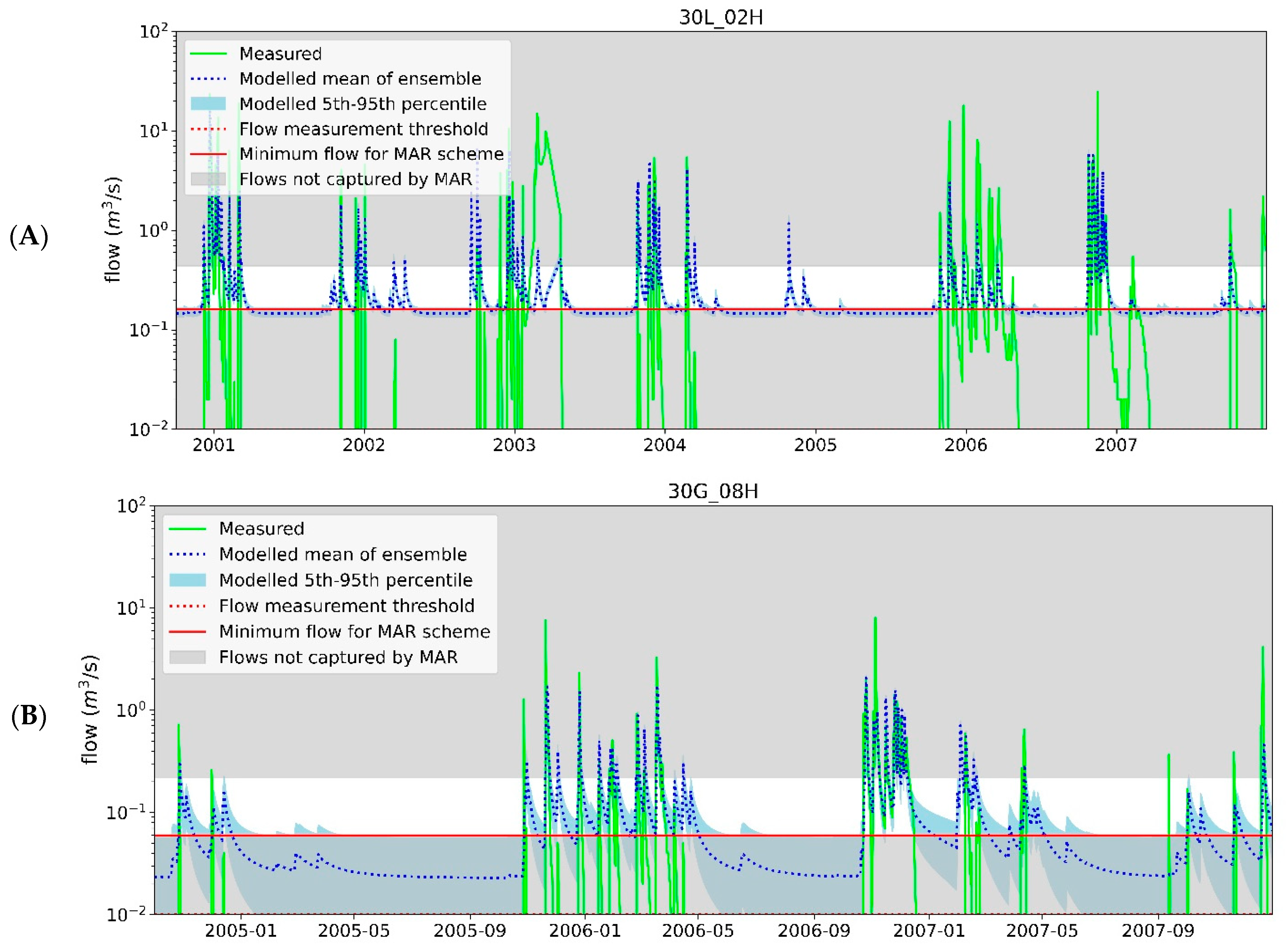
Modelled flows are shown in
Figure 4 for the ensemble mean and all members compared to the measured flows during the calibration period(s). Catchment-specific calibration periods were selected based on the availability and quality of the measured data. The timing and duration of the flow events are reasonably well matched, although the modelled flows cannot match the recorded peak flows. There are also some instances where flow events occur in the data that are not recorded by the model, possibly reflecting areal variations in the intensity of rainfall that are not seen in the catchment averaged rainfall data.
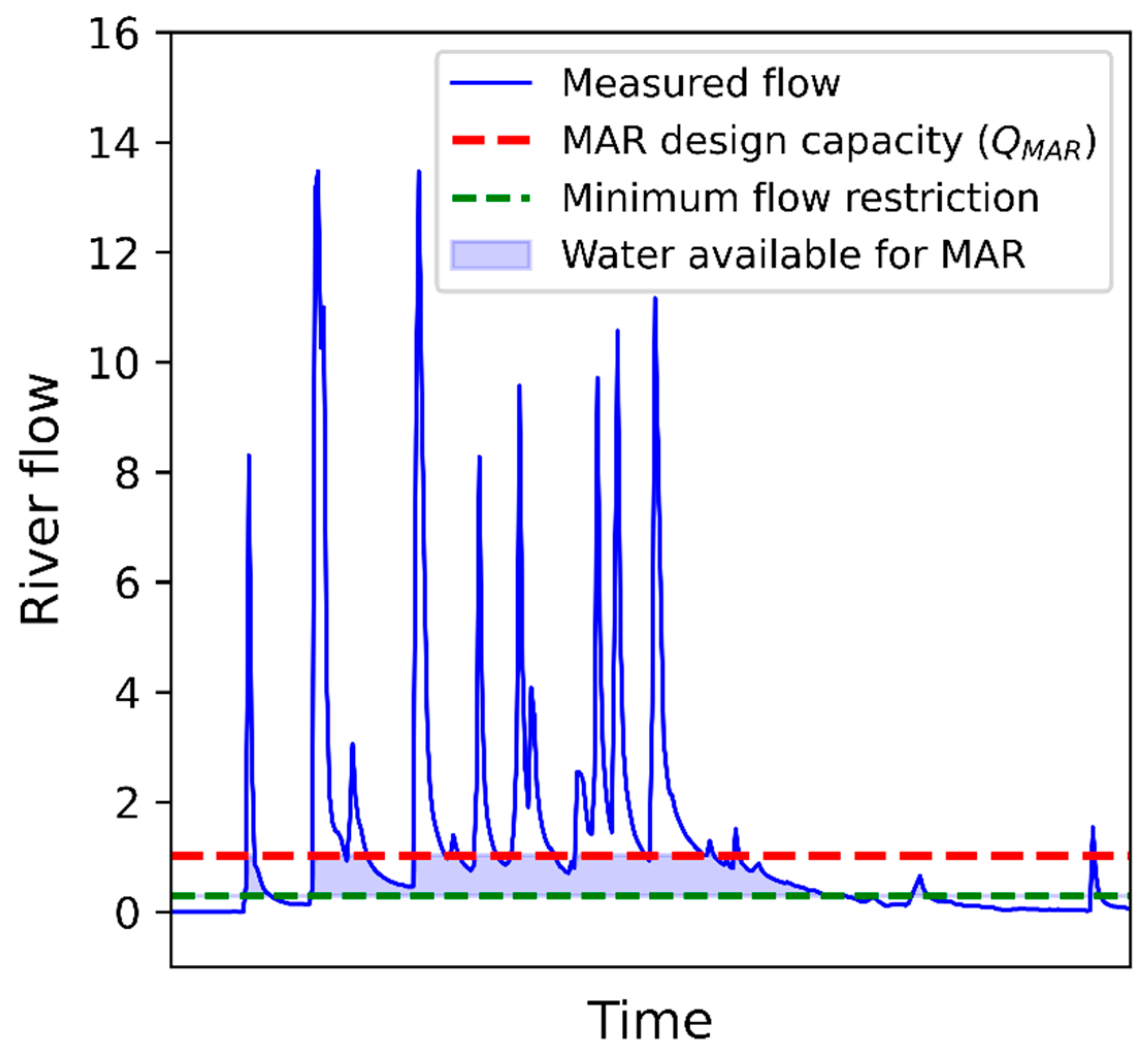
Divergence between measured and modelled occurs at very low flows. River flows have a minimum recorded flow of 0.01 m3/s, with a measurement resolution of 0.01 m3/s. Rainfall-runoff models using exponential functions cannot model zero flows and even with the best-matched parameter sets, the “tail” of the modelled flows indicates flow where measured flows are <0.01 m3/s.
The under-recording of the peaks is unlikely to present a problem for the estimation of water available for MAR, as these peaks are likely to be far higher than the engineered capacity for MAR. However, the use of modelled flows at low flows could have a large impact on the modelled MAR recharge, potentially overestimating MAR recharge where modelled flows are greater than measured. This was avoided by setting minimum flows (
QMIN), above which an MAR scheme operates. Minimum flows were set to the flows at which the modelled flows diverge from measured for each catchment, with examples shown in
Figure 5, which shows measured vs. modelled river flows on a log scale, demonstrating the selection of
QMIN at the point where measured and modelled flows diverge to address model limitations.
The QMIN selected were 0.3 m3/s (29E_01H), 0.1 m3/s (31J_01H), 0.16 m3/s (30L_02H) and 0.06 m3/s (30G_08H). These may result in conservative (low) estimates of MAR recharge but given that an unknown environmental flow requirement would likely be imposed on any MAR scheme, this approach allows a simple rainfall-runoff model to be used to estimate MAR recharge.
3.3. Regional MAR Estimation
For the baseline period (2000–2021), the annual average MAR recharge (
QR) achieved for each of the modelled catchments based on a range of MAR design capacities,
QMAR, are shown in
Figure 6. The median of the ensemble is presented along with the 5–95
th percentile values, indicating that uncertainty in
QR varies considerably, from very little at 31J/01H (Rio Seco), to >1 Mm
3/yr at
QMAR of 40,000 m
3/d for 30G_08H and 29E_01H. The uncertainty is positively correlated with river flow and reflects the increased measurement error at higher flow rates.
Estimated
QR based on climate change scenarios are also shown in
Figure 6 for the RCP4.5 and RCP8.5 scenarios for 2041–2070, alongside the
QR predicted for the observed historical period (1970–2000) used in the development of the climate models. In all cases, the observed historical resulted in higher
QR for a given
QMAR than either of the two climate change scenarios. The results for 30G_08H and 30L_02H show recent baseline MAR estimates falling between the observed historical and the RCP4.5 scenario for 2041–2070, which may be expected from an increasingly dry climate. However, the recent baseline (2000–2021) for the other two catchments is very different. At 29E_01H, the large catchment on the west coast adjacent to the Alentejo boundary, the recent baseline is significantly wetter than the observed historical, resulting in higher
QR for the baseline than for the observed historical, perhaps indicating that MAR predicted under climate change may be overly pessimistic. However, at the 31J_01H (Rio Seco), a very small catchment in the Central Algarve, the MAR estimate during the recent baseline scenario is lower than all the climate scenarios, indicating the vulnerability of small catchments to increasing flow intermittency under climate change, which is already occurring to a greater extent than regional models suggest.
Climate change impacts on
QR for a
QMAR of 30,000 m
3/d for all modelled catchments are shown in
Figure 6, showing the decrease in
QR under the RCP4.5 and 8.5 scenarios for 2041–2070. Relative percentage changes for those catchments where the climate change predictions are consistent with the recent baseline conditions (30L_02H and 30G_08H) indicate that decreases in
QR of between 8–13% and 16–23% are predicted for the RCP4.5 and RCP8.5 scenarios, respectively.
Maintaining
QR at the baseline rates requires additional design capacity due to the reduction in available river flows and therefore the need to capture a greater proportion of river flow during less frequent flow events to maintain the same
QR under climate change. A feature of MAR schemes is that
QMAR can be relatively easily increased by adding additional recharge boreholes/basins, etc., over time to mitigate the effects of climate change and maintain baseline
QR. However, as shown in
Table 3, there is a greater benefit in maintaining
QR in catchments with higher annual flows where the same increase in
QMAR will increase
QR by 1.26 Mm
3/yr at 29E_01H compared to only 0.2 Mm
3/yr for 30L_02H. For each of these catchments, there will be an optimal
QMAR considering the cost vs. water resource benefit.
To estimate MAR recharge for catchments that were not modelled, linear regression between annual average river flow and
QR was estimated for a range of
QMAR for the modelled catchments. An example for a
QMAR of 30,000 m
3/d is shown in
Figure 7a. These relationships were used to estimate
QR for the remaining catchments of interest based on annual average river flow (either gauged or estimated) and the respective
QMAR from
Table 2 (
Figure 7b). Many factors affect
QMAR (e.g., budget, land availability, aquifer properties), therefore the impact on MAR recharge achieved for a range of
QMAR is also shown in
Figure 7b.
The error bars indicate the range of QR achieved based on the ensemble of rainfall-runoff models, indicating that uncertainty generally increases with increasing annual average river flow, except for catchment 30G_08H, which experiences higher uncertainty in QR. Uncertainty in river flows for the unmodelled catchments is clearly uncertain, but likely to be positively correlated with river flow. The uncertainty in MAR recharge for unmodelled catchments was estimated based on one selected catchment (29E_01H) and the appropriate QMAR of each potential MAR scheme to provide an indication of the potential uncertainty in the QR estimates for the unmodelled catchments.
3.4. Source Water Quality
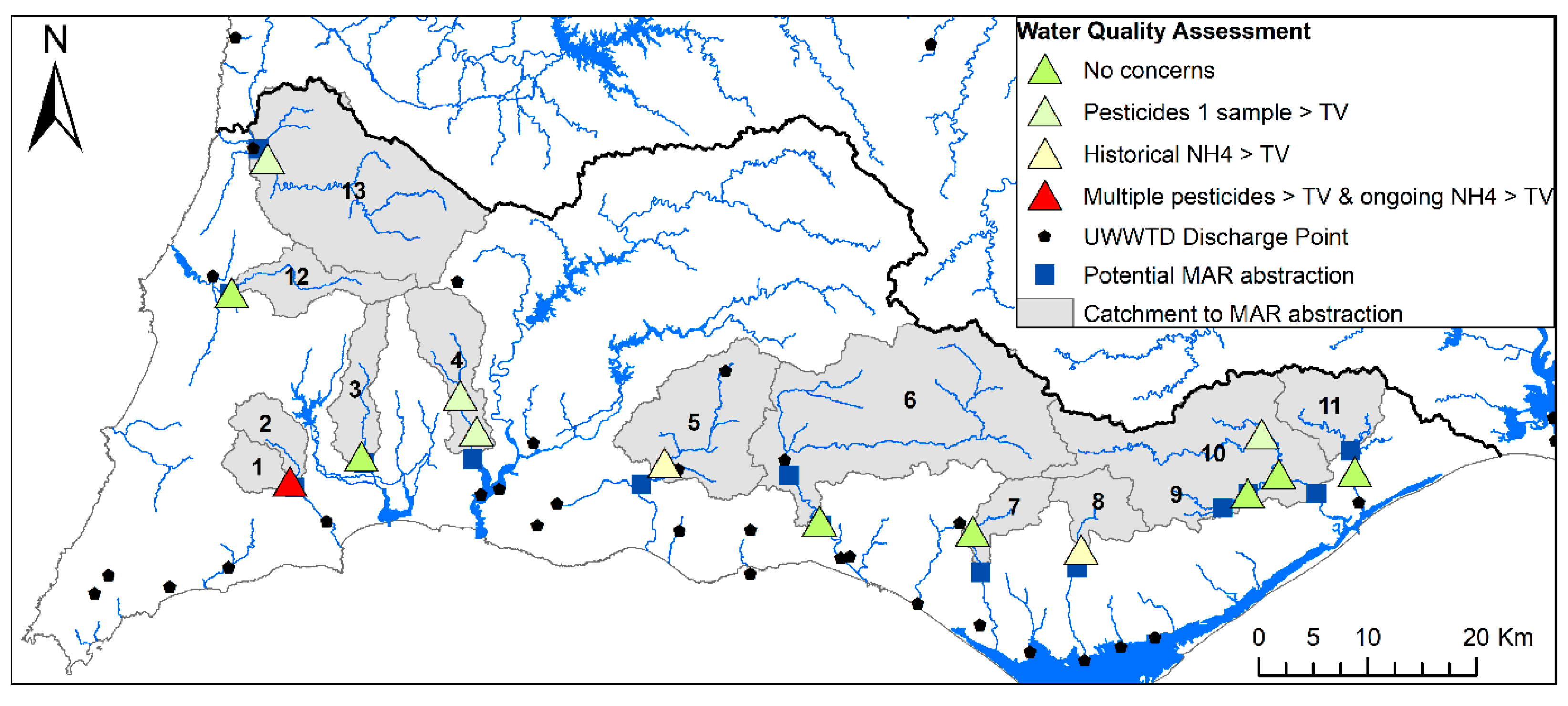
An assessment of the surface water quality based on the nearest surface water monitoring stations to the proposed surface water abstractions for MAR was undertaken (shown in
Figure 8) using all available data (samples collected between 1995 and 2020). All potential catchments have at least one surface water monitoring location except for catchment 2. Full results are presented in the
Supplementary Material (Tables S2–S6). Generally, the catchments have little agricultural or urban development and contamination risks are low. Furthermore, the proposed abstractions for MAR are upstream of water treatment plant (WTP) discharge in all but two cases (catchments 5 and 6).
Surface water quality meets the requirements of the Groundwater Directive with only rare exceptions and MAR with this source of water should not present undue risks to the achievement of good water quality status for the receiving groundwater body. No water quality concerns were identified at the majority of locations, and at a further four locations, only a single exceedance of a single individual pesticide occurred (in all cases for tributylphosphate). Two locations with historical ammoniacal nitrogen (NH4) concentrations were identified (catchments 5 and 8) but these do not appear to be ongoing and may reflect improvements in waste-water collection and treatment since the analysis started in 1995. Only water from Ribeira de Bensafrim (catchment 1) regularly fails to meet the groundwater threshold values (for NH4, chloride and pesticides) and may be unacceptable to use for MAR.
3.5. MAR Scheme Costs
Costs for MAR schemes (using river/storm water) recharging by infiltration and spreading basins are cheaper in comparison to those using recharge wells/boreholes [
48]. MAR schemes using natural water sources and recharge wells were found to have average levelised costs of USD 0.45/m
3 based on five schemes, compared to an average of USD 0.19/m
3 for infiltration basins, based on eight schemes [
49]. The Los Arenales MAR scheme in Castilla y Leon, Spain, is probably the most similar in terms of location and MAR type to those proposed in the Algarve, recharging on average 2.4 Mm
3/yr for a capital cost of EUR 5.27 MILLION, i.e., a unit cost of EUR 2.2/m
3/yr in the Algarve [
49]. The estimated levelised cost of this scheme is USD 0.21/m
3.
Identified MAR options were compared to other supply and demand measures by area or water resource zone. Other options have their basis in the RWEP [
4], or by other previous studies, e.g., [
3]. Levelised costs for the measures of the RWEP were not available; therefore, costs were compared using unit costs (the estimated capital costs divided by the average water resource benefit in EUR/m
3/yr). At this stage, MAR schemes in the Algarve are assumed to have similar unit costs of EUR 2.2/m
3/yr to those from Los Arenales.
MAR costs compare favourably to those in the RWEP, where the 57 short-medium-term measures of the RWEP to generate/save 33 Mm3/yr cost on average EUR 6/m3/yr, reuse of treated wastewater directly for nonpotable uses has an estimated cost of EUR 2.6/m3/yr, while rehabilitation of irrigation networks is estimated to cost EUR 4/m3/yr. Costs for desalination are understood to be significantly higher still. MAR, therefore, has unit costs lower than almost all the feasible alternatives.
3.6. Summary
The estimated annual average additional recharge that MAR schemes could achieve across the Algarve region (RH8) is 27 Mm
3/yr for an estimated cost of EUR 60 million, as shown in
Table 4.
MAR is unlikely to be possible for M2 due to the water quality risks identified in the proposed water source, Ribeira de Bensafrim, but none of the other catchments appear to have significant water quality issues. The MAR estimate from Rio Seco is small in comparison to the other options and the recent historical period indicates that river flows in this small stream are already lower than predicted by the RCP8.5 scenario for 2041–2070, limiting the potential for MAR recharge in this area. The adjacent Ribeira da São Lourenço catchment is expected to be similarly affected.
Based on this initial assessment, MAR in M3, M6, M7, M13–M15, in the area east of Tavira and the area south of Odeceixe appear to have higher chances of success on water quality and climate change considerations. These schemes could provide a water resource benefit of 24 Mm
3/yr to support the irrigation perimeters at Alvor, Sotavento and the Mira within RH8, as well as developing/maintaining a strategic emergency groundwater resource in M6/M7, close to the major population centre of Albufeira. These schemes are depicted in
Figure 9.
4. Discussion
4.1. Supporting Public Irrigation Perimeters
The extent to which MAR could replace surface water in public irrigation perimeters is summarised in
Table 5. MAR can form a significant proportion of the total water demand in the Alvor (32%) irrigation perimeter, which is usually supplied by the Bravura reservoir. This is significant because, during recent droughts, irrigation supplies from Bravura were temporarily stopped to maintain urban supplies as a priority and reliable supplies are needed for all users during drought periods.
Known alternatives to the Bravura dam during droughts are limited to reducing losses in the irrigation system (2 Mm3/yr; EUR 4/m3/yr), reactivation of former municipal boreholes (0.9 Mm3/yr, no costs available) and, in the long term, treated water reuse with the closest WTP at Lagos generating 4.0 Mm3/yr, with anticipated costs of EUR 2.6/m3/yr. All these water resource options appear to be necessary in order to meet the irrigation demand, particularly during drought periods.
In the Sotavento irrigation perimeter, it was identified [
50] that involuntary MAR has been occurring since irrigation with surface water commenced in 2001, resulting in groundwater levels no longer having significant seasonal fluctuations. The limitation in the Sotavento irrigation perimeter is likely to be the aquifer storage; however, by managing groundwater levels and abstraction, MAR can be used to maximise seasonal groundwater storage.
The Mira irrigation perimeter covers 1855 ha within RH8, south of the River Seixe and is supplied with only 1.5 Mm
3/yr from Santa Clara reservoir (of 30–37 Mm
3/yr total), along the Canal do Rogil [
51]. Therefore, MAR can form >100% of the demand in the irrigation perimeter in RH8 and, furthermore, MAR could form 20% of the total Mira irrigation demand. MAR in RH6 (Alentejo) has not been considered as part of this work; however, the same permeable formations are known to occur in this region and in addition to the River Seixe, the water not used for irrigation from Santa Clara (during the winter months, but still released into the irrigation network) could be an additional source of water for MAR. A strategic transfer of water from the Santa Clara dam to the Algarve (via the Rogil canal) is already being considered as one of the long-term measures considered in the RWEP, and potentially this could be augmented/replaced by MAR in this area.
4.2. A Strategic Groundwater Resource
The aquifers M6 and M7 are used for private irrigation of agriculture, tourism and golf. The river flows in the Ribeira da Quarteira proposed for MAR schemes in both M6 and M7 to increase aquifer storage can develop a strategic groundwater resource (average 9 Mm3/yr) for use during drought periods to augment urban supplies. Potentially, this could be further supported by reducing groundwater abstraction in these aquifers by replacing groundwater with treated wastewater reuse in agriculture, as approximately 2.9 and 2.8 Mm3/yr are available from the nearby Vilamoura and Vale Faro WTP, respectively.
4.3. Campina de Faro
Groundwater is used in the Campina de Faro aquifers for the golf, tourism and agriculture sectors, with current abstraction in M18, M19 and M11 totalling 12.80 Mm
3/yr. Long-term annual recharge to these aquifers is estimated to be significantly lower than this at 8.83 Mm
3/yr. As already identified [
8], abstraction reductions of at least 70% are needed and MAR with the local water sources is insufficient to solve the problem of seawater intrusion [
21]. In this area, MAR can only form a very small component of the solution, particularly as the recent baseline (2000–2021) water available for MAR is already less than even the RCP8.5 scenario due to the vulnerability of ephemeral streams with small catchments to climate change.
4.4. Regional Impact
This study has shown that MAR, using ephemeral river flow as the water source, could achieve a regional water resource benefit of at least 24 Mm3/yr, or 10% of the current water use in the Algarve. The main identified objective for MAR is to support the surface-water-fed irrigation perimeters, reducing the reliance on surface water in the major reservoirs, resulting in saving 15 Mm3/yr for other purposes. Although the benefits are achieved initially at the irrigation perimeters (Alvor, Sotavento and Mira), these would have a wider impact by reducing the demand on the major supply reservoirs (Bravura, Odeleite, Beliche and Santa Clara), thus increasing the water available for urban and other sectors.
MAR can also be used to develop and maintain a strategic aquifer resource of around 9 Mm3/yr in M6 and M7 for use during drought periods. A network of supply boreholes could re-abstract the water during significant droughts into the multimunicipal network for public supply.
Although implemented at multiple sites locally, MAR can achieve a regional benefit of a similar scale to the longer-term water resource options being considered such as the proposed desalination plant (pilot 8 Mm3/yr), the proposed abstraction from the River Guadiana with transfer to the Odeleite/Beliche reservoirs (30–60 Mm3/yr) or the 57 short-medium-term measures of the RWEP to generate/save 33 Mm3/yr.
Analysis of the surface water quality identified that the groundwater threshold values for good status under the WFD could be met, with only a couple of sporadic exceptions where further investigation is warranted and only one catchment where a combination of low river flows and surface water quality issues possibly preclude MAR (Ribeira de Bensafrim/M2). By focusing on water sources that are likely to meet the requirements of the Groundwater Directive, MAR can be more easily implemented under current legislation.
Climate change is expected to reduce the water available for MAR in the Algarve and should be considered during the planning of MAR. The RCP4.5 scenario for 2041–2070 (covering a 30-year typical design life of civil infrastructure) indicates relatively small reductions in MAR compared to the recent baseline conditions. These can be mitigated by increasing MAR capacity incrementally as climate impacts happen. Only the smallest catchments in the Central Algarve (Rio Seco and Ribeira da São Lourenço) appear to be unsuitable for MAR due to recent baseline conditions indicating that flows are already lower than the RCP8.5 climate scenarios predict, demonstrating that for the Campina de Faro aquifer, alternative integrated water resource management solutions must be found. Irrigation with wastewater using the wastewater generated from Faro-Olhão and other WTP appears to be the more suitable option.
MAR can bring wider benefits including making use of a water resource that otherwise cannot be captured and is rapidly lost to sea and fewer environmental impacts compared to the expected impact of new surface water dams, long transfer pipelines or desalination plants. Furthermore, as recharge can usually occur under gravity and treatment requirements are limited to presettlement, energy costs for MAR can be similar to those for conventional groundwater abstraction. MAR can have a positive impact on the WFD surface water objectives by increasing baseflow to rivers and groundwater-dependent wetlands. In areas where the groundwater is shallow and known to be influenced by irrigation return (such as M15 Luz-Tavira), MAR with natural water sources comes with lower water quality risks than direct irrigation with treated wastewater.
The potential for MAR in the Algarve could be greater than this study indicates, as the Querença-Silves aquifer (M5), the largest aquifer in the Algarve, could not be assessed using this method due to the complexity of river–aquifer interactions in the rivers draining this aquifer. MAR potential here could be assessed based on previous numerical modelling [
52] combined with the field knowledge of [
53,
54] to determine where and how MAR could be implemented in M5. Other extensions to this work could include identifying the optimum
QMAR at each location and between locations, particularly once country-specific and itemised costs are available. Site-specific hydrogeological investigations coupled with numerical modelling are needed to progress these options further.
5. Conclusions
The Algarve suffers from extreme water scarcity, with existing water resources unable to meet the demand, particularly in drought years. Climate change, in conjunction with population growth, will result in greater demands at a time when less water is available. Conventional water resources now need to be supplemented with alternative water resources, such as MAR, treated wastewater reuse and desalination, in a way that is cost-effective while limiting environmental impacts.
In summary, MAR is a low-regret climate adaptation measure and, in the Algarve, can potentially form 10% of the current annual water demand using water from natural sources. MAR can be achieved within the current WFD regulations provided a pathway to obtaining a licence can be developed. MAR can be achieved at a lower cost and without the environmental consequences associated with the construction of new dams or desalination plants and with lower energy requirements. MAR can support public irrigation perimeters and, in conjunction with the direct reuse of treated wastewater and reduced groundwater abstraction, provide a strategic groundwater resource for use during drought periods. Further site-specific investigations will be necessary, but the technical challenges and their solutions are well understood from a European and worldwide network of case studies where MAR is already implemented.


