
Network Theory to Reveal Ionospheric Anomalies over North America and Australia


Abstract
:1. Introduction
2. Materials and Methods
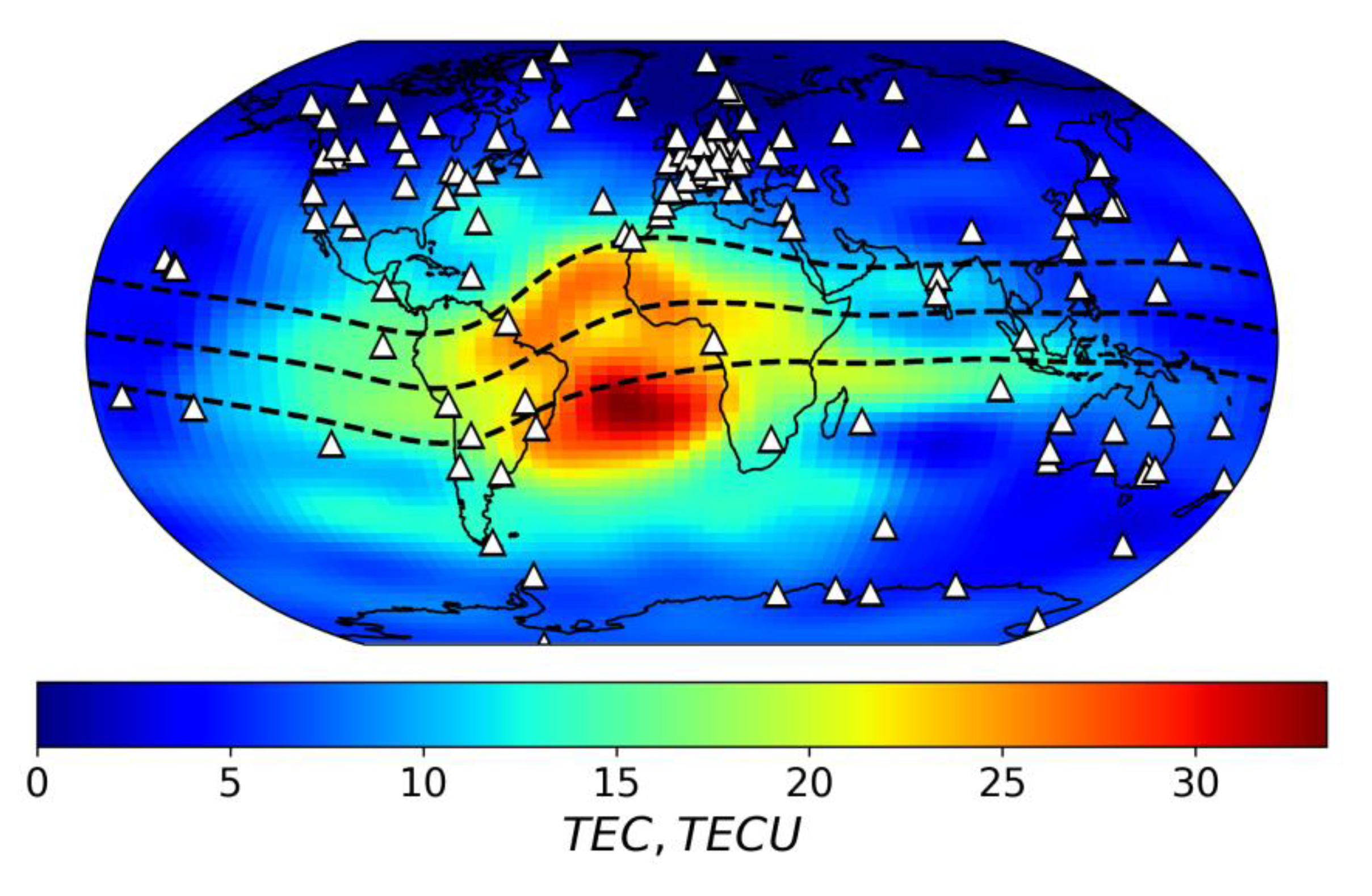
2.1. Data
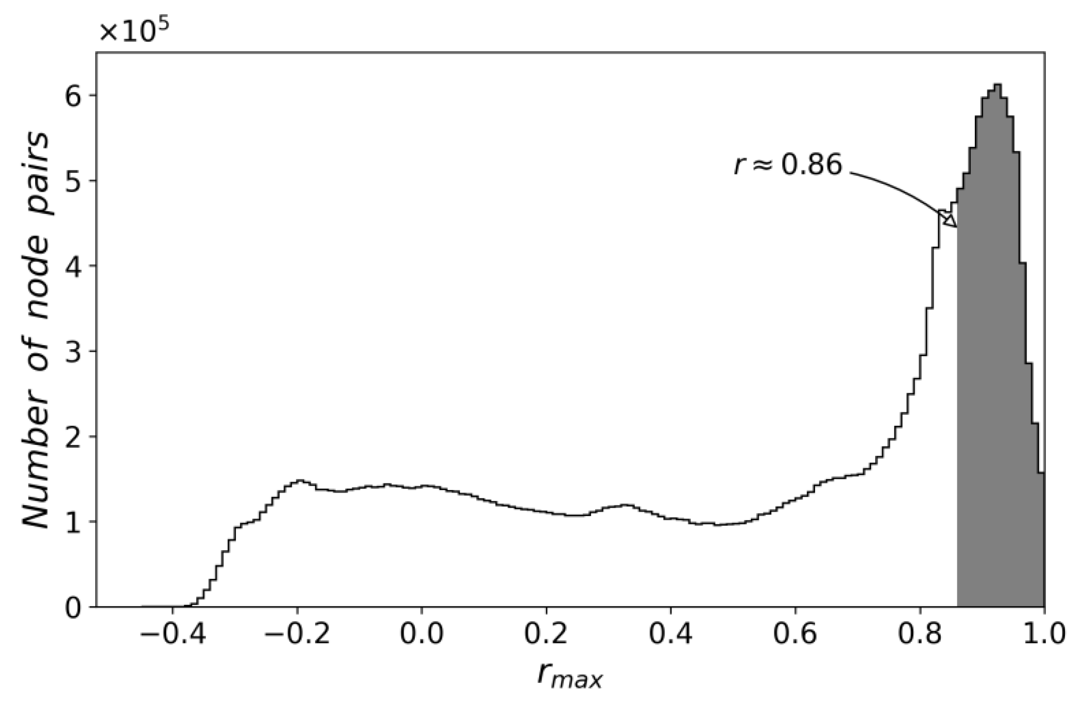
2.2. Method
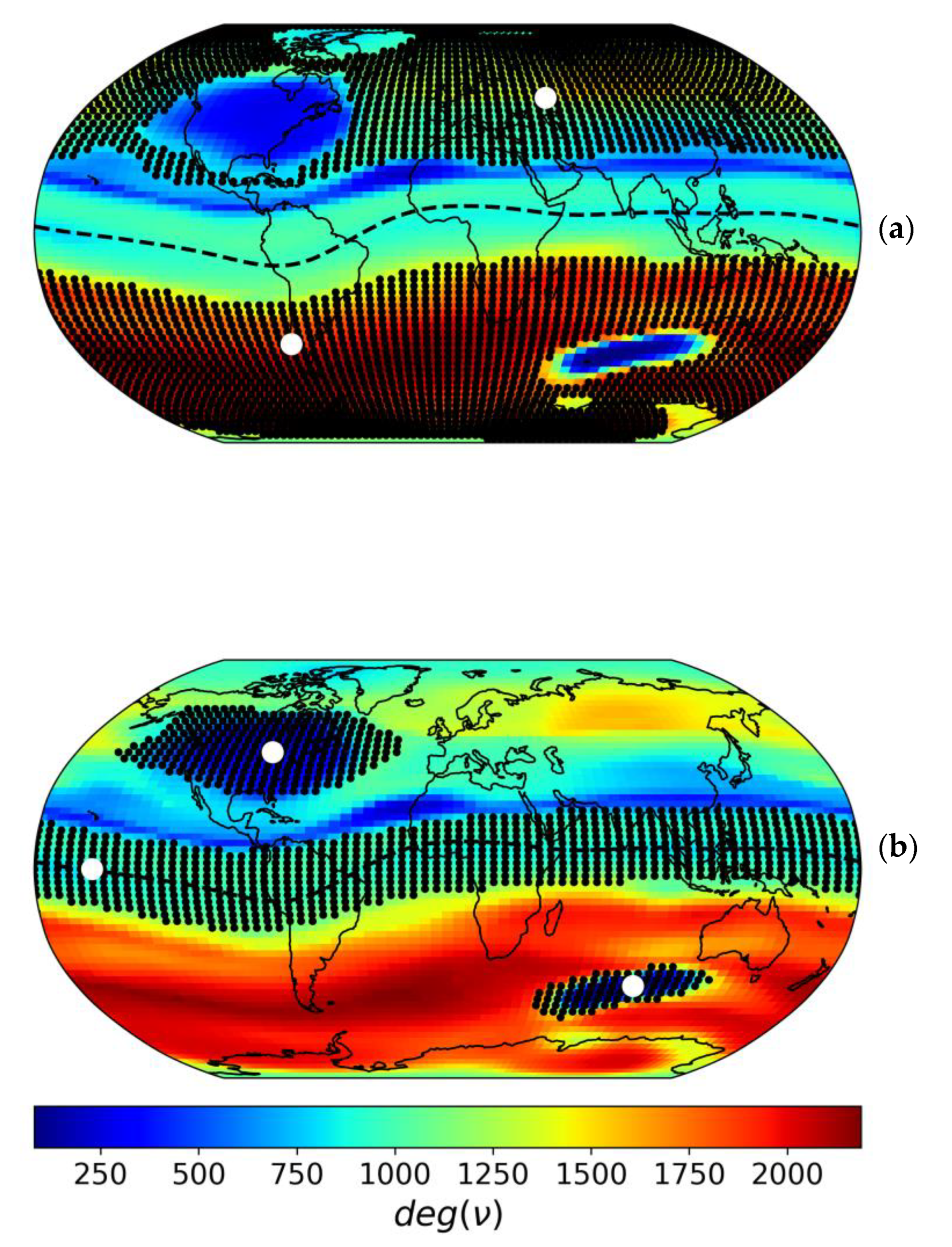
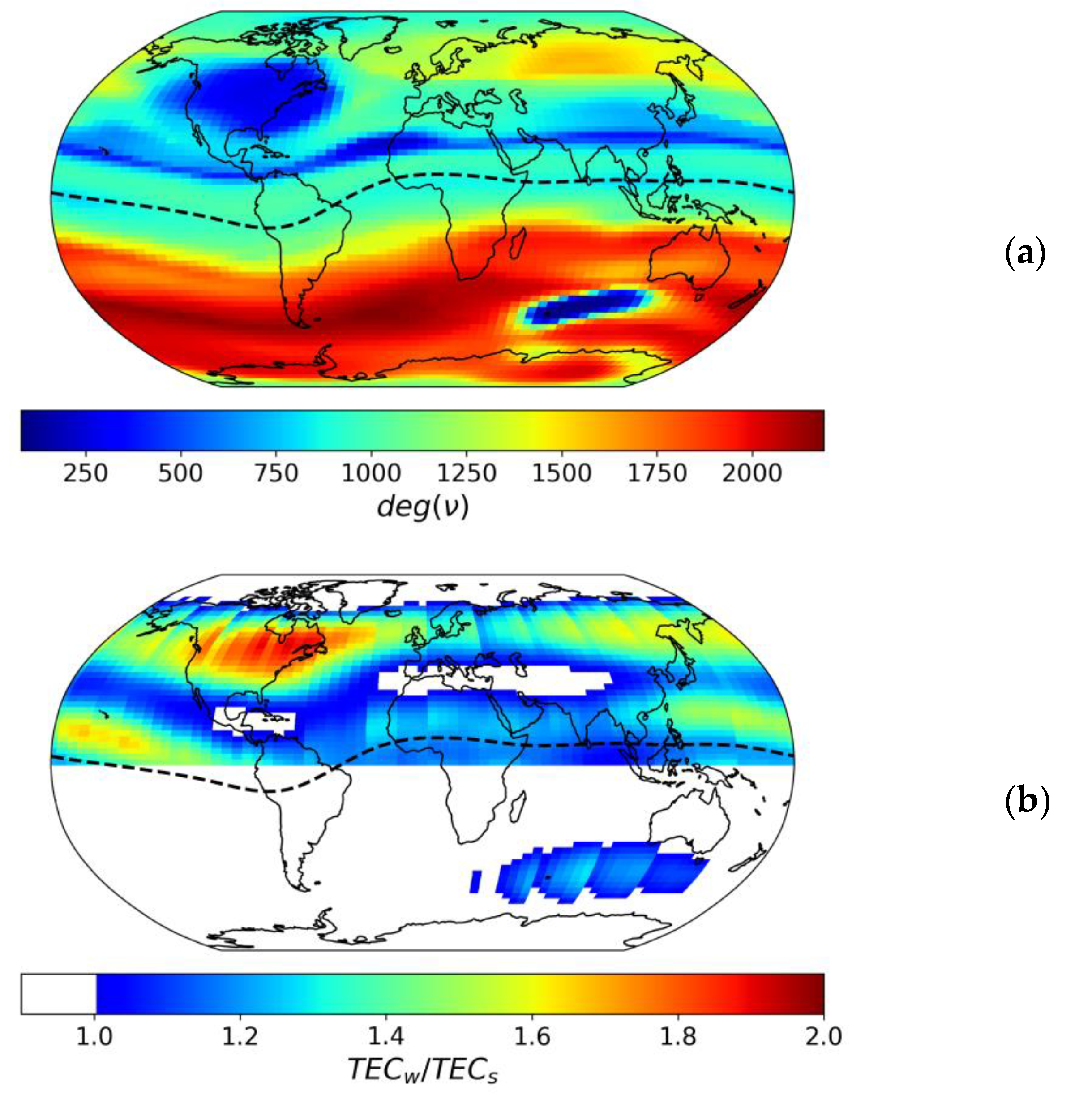
3. Ionospheric Network
4. Discussion
5. Conclusions
Author Contributions
Funding
Data Availability Statement
Acknowledgments
Conflicts of Interest
References
- Cannon, P.S. Mitigation and exploitation of the ionosphere: A military perspective. Radio Sci. 2009, 44, RS0A20. [Google Scholar] [CrossRef] [Green Version]
- Hofmann-Wellenhof, B.; Lichtenegger, H.; Wasle, E. GNSS—Global Navigation Satellite Systems. GPS, GLONASS, Galileo, and more; Springer: Wien, Austria, 2008; p. 518. ISBN 978-3-211-73012-6. [Google Scholar] [CrossRef] [Green Version]
- Rishbeth, H. Some problems of the F region. Radio Sci. 1974, 9, 183–187. [Google Scholar] [CrossRef]
- Giraud, A.; Petit, M. Ionospheric Techniques and Phenomena; Springer: Dordrecht, The Netherlands, 1987; p. 265. [Google Scholar] [CrossRef]
- Rishbeth, H. How the thermospheric circulation affects the ionospheric F2-layer. J. Atmos. Sol. Terr. Phys. 1998, 60, 1385–1402. [Google Scholar] [CrossRef]
- Rishbeth, H.; Mendillo, M. Patterns of F2-Layer Variability. J. Atmos. Sol-Terr. Phys. 2001, 63, 1661–1680. [Google Scholar] [CrossRef]
- Karpachev, A.; Gasilov, N.; Karpachev, O. Morphology and causes of the Weddell Sea anomaly. Geomagn. Aeron. 2011, 51, 812–824. [Google Scholar] [CrossRef]
- Klimenko, M.; Klimenko, V.; Ratovsky, K.; Zakharenkova, I.; Yasyukevich, Y.V.; Korenkova, N.; Cherniak, I.; Mylnikova, A. Mid-latitude Summer Evening Anomaly (MSEA) in F2 layer electron density and Total Electron Content at solar minimum. Adv. Space Res. 2015, 56, 1951–1960. [Google Scholar] [CrossRef]
- Bilitza, D.; McKinnell, L.-A.; Reinisch, B.; Fuller-Rowell, T. The International Reference Ionosphere (IRI) today and in the future. J. Geod. 2011, 85, 909–920. [Google Scholar] [CrossRef]
- Ovodenko, V.B.; Trekin, V.V.; Korenkova, N.A.; Klimenko, M.V. Investigating range error compensation in UHF radar through IRI-2007 real-time. Adv. Space Res. 2015, 56, 900–906. [Google Scholar] [CrossRef]
- Abraham, S.; Le Vine, D.M. Use of IRI to model the effect of ionosphere emission on earth remote sensing at L-band. Adv. Space Res. 2004, 34, 2059–2066. [Google Scholar] [CrossRef]
- Klobuchar, J.A. Ionospheric time-delay algorithm for single-frequency GPS users. IEEE Trans. Aerosp. Electron. Syst. 1987, 23, 325–331. [Google Scholar] [CrossRef]
- European Union. European GNSS (Galileo) Open Service-Ionospheric Correction Algorithm for Galileo Single Frequency Users. 1.2. 2016. Available online: http://www.gsc-europa.eu/system/files/galileo_documents/Galileo_Ionospheric_Model.pdf (accessed on 13 July 2022).
- Wang, N.; Li, Z.; Yuan, Y.; Huo, X. BeiDou Global Ionospheric delay correction Model (BDGIM): Performance analysis during different levels of solar conditions. GPS Solut. 2021, 25, 97. [Google Scholar] [CrossRef]
- Angrisano, A.; Gioia, C.; Gaglione, S.; del Core, G. GNSS Reliability Testing in Signal-Degraded Scenario. Int. J. Navig. Obs. 2013, 2013, 870365. [Google Scholar] [CrossRef]
- McGranaghan, R.M.; Mannucci, A.J.; Verkhoglyadova, O.; Malik, N. Finding multiscale connectivity in our geospace observational system: Network analysis of total electron content. J. Geophys. Res. Space Phys. 2017, 122, 7683–7697. [Google Scholar] [CrossRef]
- Lu, S.; Zhang, H.; Li, X.; Li, Y.; Niu, C.; Yang, X.; Liu, D. Complex network description of the ionosphere. Nonlin. Processes Geophys. 2018, 25, 233–240. [Google Scholar] [CrossRef]
- Roma-Dollase, D.; Hernández-Pajares, M.; Krankowski, A.; Kotulak, K.; Ghoddousi-Fard, R.; Yuan, Y.; Li, Z.; Zhang, H.; Shi, C.; Wang, C.; et al. Consistency of seven different GNSS global ionospheric mapping techniques during one solar cycle. J. Geod. 2018, 92, 691–706. [Google Scholar] [CrossRef] [Green Version]
- Schaer, S.; Beutler, G.; Rothacher, M. Mapping and predicting the ionosphere. In Proceedings of the 1998 IGS Analysis Center Workshop, Darmstadt, Germany, 9–11 February 1998; pp. 307–320. [Google Scholar]
- Mannucci, A.J.; Wilson, B.D.; Yuan, D.N.; Ho, C.M.; Lindqwister, U.J.; Runge, T.F. A global mapping technique for GPS-derived ionospheric TEC measurements. Radio Sci. 1998, 33, 565–582. [Google Scholar] [CrossRef]
- Schaer, S.; Beutler, G.; Mervart, L.; Rothacher, M.; Wild, U. Global and regional ionosphere models using the GPS double difference phase observable. In Proceedings of the IGS Workshop on Special Topics and new Directions, Potsdam, Germany, 15–17 May 1995; pp. 77–92. [Google Scholar]
- Hernandez-Pajares, M.; Juan, J.M.; Sanz, J.; Orus, R.; Garcia-Rigo, A.; Feltens, J.; Komjathy, A.; Schaer, S.C.; Krankowski, A. The IGS VTEC maps: A reliable source of ionospheric information since 1998. J. Geod. 2009, 83, 263–275. [Google Scholar] [CrossRef]
- Schaer, S.; Gurtner, W.; Feltens, J. IONEX: The IONosphere Map Exchange Format; Version 1. In Proceedings of the 1998 IGS Analysis Center Workshop, Darmstadt, Germany, 9–11 February 1998; pp. 233–247. Available online: http://ftp.aiub.unibe.ch/ionex/draft/ionex11.pdf (accessed on 13 July 2022).
- Newman, M.E.J. The structure and function of complex networks. SIAM Rev. 2003, 45, 167–256. [Google Scholar] [CrossRef] [Green Version]
- Stolbova, V.; Martin, P.; Bookhagen, B.; Marwan, N.; Kurths, J. Topology and seasonal evolution of the network of extreme precipitation over the Indian subcontinent and Sri Lanka. Nonlin. Processes Geophys. 2014, 21, 901–917. [Google Scholar] [CrossRef] [Green Version]
- Timchenko, A.V.; Bessarab, F.S.; Klimenko, M.V.; Radievsky, A.V.; Klimenko, V.V. Correlation Analysis of Global Ionospheric Total Electron Content Maps in March 2015. Geomagn. Aeron. 2022, 62, 217–226. [Google Scholar] [CrossRef]
- Schunk, R.W.; Nagy, A.F. Ionospheres: Physics, Plasma Physics, and Chemistry; Cambridge University Press: Cambridge, UK, 2009; p. 628. [Google Scholar] [CrossRef]
- Hernandez-Pajares, M.; Juan, J.; Sanz, J. New approaches in global ionospheric determination using ground GPS data. J. Atmos. Sol. Terr. Phys. 1999, 61, 1237–1247. [Google Scholar] [CrossRef]
- Zhao, B.; Wan, W.; Liu, L.; Mao, T.; Ren, Z.; Wang, M.; Christensen, A.B. Features of annual and semiannual variations derived from the global ionospheric maps of total electron content. Ann. Geophys. 2007, 25, 2513–2527. [Google Scholar] [CrossRef] [Green Version]
- Torr, M.R.; Torr, D. The seasonal behaviour of the f2-layer of the ionosphere. J. Atmos. Terr. Phys. 1973, 35, 2237–2251. [Google Scholar] [CrossRef]
- Yasyukevich, Y.V.; Yasyukevich, A.S.; Ratovsky, K.G.; Klimenko, M.V.; Klimenko, V.V.; Chirik, N.V. Winter anomaly in NmF2 and TEC: When and where it can occur. J. Space Weather Space Clim. 2018, 8, A45. [Google Scholar] [CrossRef] [Green Version]
- Tapping, K.F. The 10.7 cm solar radio flux (F10.7). Space Weather 2013, 11, 394–406. [Google Scholar] [CrossRef]
- Hunter, J.D. Matplotlib: A 2D graphics environment. Comput. Sci. Eng. 2007, 9, 90–95. [Google Scholar] [CrossRef]
- Met Office. Cartopy: A Cartographic Python Library with a Matplotlib Interface. Exeter, Devon, 2010–2015. Available online: http://scitools.org.uk/cartopy (accessed on 13 July 2022).


Publisher’s Note: MDPI stays neutral with regard to jurisdictional claims in published maps and institutional affiliations. |
© 2022 by the authors. Licensee MDPI, Basel, Switzerland. This article is an open access article distributed under the terms and conditions of the Creative Commons Attribution (CC BY) license (https://creativecommons.org/licenses/by/4.0/).
Share and Cite
Zhivetiev, I.V.; Yasyukevich, Y.V. Network Theory to Reveal Ionospheric Anomalies over North America and Australia. Atmosphere 2022, 13, 1333. https://doi.org/10.3390/atmos13081333
Zhivetiev IV, Yasyukevich YV. Network Theory to Reveal Ionospheric Anomalies over North America and Australia. Atmosphere. 2022; 13(8):1333. https://doi.org/10.3390/atmos13081333
Chicago/Turabian StyleZhivetiev, Ilya V., and Yury V. Yasyukevich. 2022. "Network Theory to Reveal Ionospheric Anomalies over North America and Australia" Atmosphere 13, no. 8: 1333. https://doi.org/10.3390/atmos13081333