Article

Simulation of the Boreal Winter East Asian Cold Surge by IAP AGCM4.1

1
CMA Earth System Modeling and Prediction Center, Beijing 100081, China
2
International Center for Climate and Environment Sciences, Institute of Atmospheric Physics, Chinese Academy of Sciences, Beijing 100029, China
*
Author to whom correspondence should be addressed.
Atmosphere 2022, 13(8), 1176; https://doi.org/10.3390/atmos13081176
Submission received: 18 May 2022 / Revised: 1 July 2022 / Accepted: 21 July 2022 / Published: 25 July 2022
(This article belongs to the Special Issue Coupled Climate System Modeling)

Abstract

:
In this study, we evaluate the performances of the Institute of Atmospheric Physics atmospheric general circulation model (IAP AGCM version4.1) and atmospheric component of Chinese Academy of Science Earth System Model, version 1 (CAS-ESM1) in the simulation of the cold surge (CS) events in East Asia. In general, the model can capture the main features of anomalous precipitation and circulation associated with the cold surge days. Compared with climatological means of boreal winter, on CS days, the precipitation increases in the southern part of the South China Sea (SCS), while decreases in the subtropical regions near the southern China. In addition, the climatological northeasterly wind over the SCS region strengthens on CS days. In the first day composites of CS events, it shows a dipole pattern in middle latitude over East Asia, with a positive (negative) sea level pressure (SLP) anomaly in the west (east). Based on the anomalous SLP signs in the two centers of the dipole pattern, the CS days can be further classified into two types: positive-west–negative-east-type and positive-west–positive-east-type. All these features can be reasonably reproduced by IAP AGCM4.1. Although in most CS days there is positive SLP anomaly in the East China, some negative events were investigated in this study. In these negative events the northerly anomaly in SCS is associated with an anticyclonic circulation anomaly around the eastern part of the Tibetan Plateau, rather than descending from the mid-to-high latitude cold air outbreaks. The feature can also be captured by the model.

1. Introduction

In boreal winter, northeasterly prevails in East Asia, along the eastern edge of the Siberian high. Along with the southward wind, cold air from North Pole and high latitude regions breaks out and induces a dramatical temperature drop throughout the East Asia and South Asia regions, which is regarded as a cold surge (CS) event [1,2]. Previous studies pointed out that the occurrence of CS may be connected to the stratospheric sudden warming and blocking events [3,4,5]. The CS event can greatly influence the mid-latitude area of East Asia. If the cold air mass is strong enough that it can reach low-latitude or even cross the equator and reach the southern hemisphere, thus inducing heavy rainfall there [6]. In January 2016, a super CS event hit eastern China and induced the temperature drop more than 10 °C in most regions in this region. During this event, more than 95% of the country experienced an extremely cold winter, with minimum temperatures below 0 °C, especially in southern China [7,8]. It is important to study CS events in winter and understand the mechanisms that control the variability of the cold surge. The more we know, the higher ability we have of predicting the CS events. This can benefit the lives of the people living in East and South Asia.
CS events in East and South Asia can be identified based on different criteria, such as temperature drop, wind speed increase or a combination of multiple factors. Song and Wu [9] analyzed associated processes in two types of CS events: one is limited to north of 40° N, and another can penetrate to south China, or even Southeast Asia. They found two factors responsible for the southward invasion of cold air to south China are the mid- to high-latitude upper-level wave train and subtropical wave train emanating from the North Atlantic. By contrast, another definition of CS events is based on meridional wind, or a combination of meridional wind speed, wind direction, and sea level pressure anomalies [10,11]. Additionally, Park et al. [12] defined CS by two types: wave train CS and blocking CS. All these methods can capture the features associated with CS events, to some extent. In another perspective, CS can be regarded as a dynamical coupling path linking middle latitude and tropical regions, which is related to the equatorial mountain torque produced by the Tibetan Plateau [13].
Recently, Pang and Lu [10] found two distinct patterns of SLP anomalies in East Asia associated with two types of CS events. The first type is characterized by a dipole pattern of SLP anomaly in East Asia, with the positive (negative) center over China (Japan). The other type is featured by widespread positive SLP anomaly over East Asia. This finding is very important for understanding the mid-latitude circulation associated with CS events and their predictability.
To better understand and predict the CS events and associated circulation, the numerical climate model is an indispensable tool. Before using the model for prediction, we should first evaluate the performances of climate models in simulating the features of CS events and related circulation. Park et al. [12] examined the two types of CS (wave train CS and blocking CS) in ten climate models in CMIP5. They show that models can well-reproduce the occurrence mechanism of the wave train CS with vertical structure, as related to growing baroclinic wave and dipole pattern associated with blocking CS.
The Chinese Academy of Sciences earth system model (CAS-ESM), a fully coupled earth system model developed mainly in the Institute of Atmospheric Physics (IAP), CAS, has participated in the six phases of the Coupled Models Intercomparison Project (CMIP6). CAS-ESM is also widely used in climate prediction and projection at global and regional scales. Thus, it is necessary to systematically evaluate the performance of the model including the simulation of the CS events and associated circulation.
In this study, we will investigate the CS events occurrence frequency and associated mid-latitude circulation simulated by IAP AGCM4, the atmospheric component of CAS-ESM. We will also investigate the interannual variation of the CS events, as well as to what extent the model can capture the interannual feature.

2. Model, Data, and Methods

The model used is IAP AGCM4.1 [14,15]. The horizontal resolution of IAP AGCM4.1 is 1.4° × 1.4° with 30 vertical levels. The dynamic core of IAP AGCM4.1 is inherited from IAP AGCM4.0, and physical package is the same as CAM5. Detailed information of physical parameterizations in CAM5.0 can refer to the technical description [16]. IAP AGCM has been widely adopted in research of the climate system at global and regional scales, including East Asia monsoon, hourly precipitation, West African climate, Aleutian Low–Icelandic Low seesaw, tropical cyclones, and summer hot days in China [17,18,19,20,21,22].
In this study, IAP AGCM4.1 is run following the Atmospheric Model Intercomparison Project (AMIP) protocols [23], and daily outputs are used. In the AMIP simulations IAP AGCM4.1 is driven by the observed monthly sea surface temperatures (SST) and sea ice as the boundary conditions. The simulation period is from 1 January 1979 to 31 December 2005. Usually, a large ensemble size of simulations is adopted to separate the externally forced signal from the internal variability of the climate system [24]. Due to the fact that the focus of this study is to investigate the composites of cold surges and associated circulation features, we use one single simulation, which can represent the model performance in simulating the features of cold surges. To evaluate the model performances, we also use the daily ERA-Interim reanalysis during the period from 1979 to 2018 [25]. ERA-Interim is provided at a horizontal resolution of 0.75° × 0.75°. In addition, we also use Tropical Rainfall Measuring Mission (TRMM) precipitation data, which covers the period of 1998–2017.
Cold surge day and cold surge events are defined following Lim et al. [11]. Lim et al. [11] defined two domains around Southeast Asia region (D1, 5–10° N, 107–115° E) and (D2, 18–22° N, 105–122° E), and a cold surge day is defined if the following criterion is met: area-averaged wind in D1 is northerly (v < 0 m/s) and easterly (u ≤ 0 m/s) and area-averaged wind velocity should be at least 0.75 standard deviations larger than long-term mean, i.e., within the domain D2 the maximum SLP exceeds 1020-hPa. A cold surge event is identified if the duration of consecutive cold surge days is longer than 2 days. The maximum allowable gap among cold surge days is 2 days in one event; otherwise, it is regarded as two events. Table 1 shows the statistics of the observed and simulated CS. In observation, 619 CS days has been identified during the study period. These CS days can be regarded as 120 CS events, with averaged duration of 5.18 days per event. In the simulation, there are 489 CS days (489), which is 21% less than observation. Correspondingly, 97 CS events is identified with averaged duration 4.93 days per event. The underestimated number of CS days, and events may be associated with the stronger wind velocity in the simulation. The simulated climatological lower-level wind velocity in the study area is 8.65 m/s, larger than the observed 8.07 m/s. Additionally, the standard deviation of velocity is also larger in simulation (3.58 m/s) compared with observation (2.95 m/s). Anyway, the SLP bias also contributes to the underestimation of the CS days in the simulation. If the SLP limitation in CS definition is unconsidered, the underestimation of the simulated CS days can be reduced (Table 1, 701 CS days in observation versus 641 in simulation).

3. Results

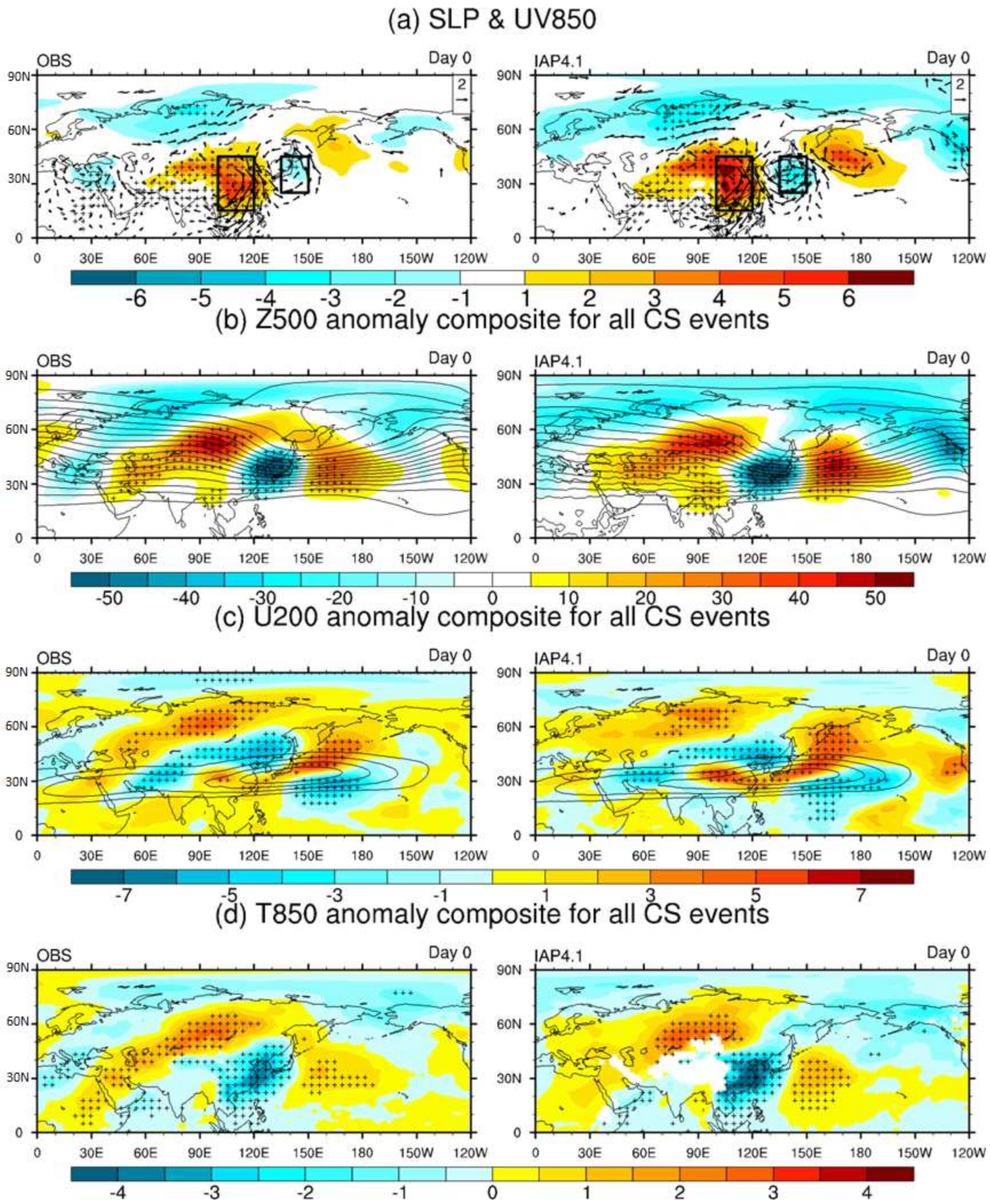
3.1. Mid-to-High Latitude Circulation Associated with CS Events

The occurrence of CS is intimately related to the middle to high latitude general circulation pattern [10]. Figure 1 shows the first day composite of three-dimensional circulations in northern hemisphere for all CS events in observation and IAP AGCM4.1 simulation. At the beginning of one CS event, the SLP over East Asia shows a wave-like pattern from East Asia along the way northeastward to North Pacific, with significantly positive anomaly center over continental East China and negative anomaly center over Japan. The positive (negative) SLP anomaly is accompanied with low level anticyclonic (cyclone), indicating the strengthening of the southward outbreak of cold air from high latitude along the coastline of the East Asia. The observed anomalous pattern can be reasonably reproduced by IAP AGCM4.1, although with slightly overestimated strength of the anomalous centers. Note that the model also overestimates the northeasterly associated with CS days over SCS (Figure 2). Thus, the overestimation of anomalous circulation intensity in low latitudes may result from the overestimation in middle latitudes.
In middle layer of the atmosphere, CS events begin with the deepening of the East Asian trough over southern part of Japan, along with the intensified ridges in the upstream and downstream of the trough (Figure 1b). In the upper-level, the westerly jet over southern Japan and western North Pacific moves northeastward associated with CS events (Figure 1c). Due to the anticyclonic anomaly over eastern China and southward cold air movements, the local temperature drops and lower-level over eastern China, and southern Japan experiences cooling (Figure 1d). Meanwhile, to the east and west sides of the cold anomaly center the local air temperature rises due to the associated warm advection from lower latitudes. These features for the outbreak of CS events can be reasonably captured by IAP AGCM4.1, both the location and magnitude of the anomaly centers.
Although Figure 1 shows that associated with CS events outbreak, SLP exhibit a dipole pattern over East Asia, with a positive center in the west and negative center in the east. However, there is an asymmetry feature that the magnitude of the positive center is stronger than the negative one. Pang and Lu [10] found that the above feature is due to the different types of the CS events. They further classified the CS events into two types. Figure 2 shows a scatterplot of two indices of SLP anomalies at day 0 for all cold surge events. Here, the western index (W-index) is defined as the average SLP anomalies over 15° N–45° N, 110° E–120° E and the eastern index (E-index) as the average anomalies over 25° N–45° N, 135° E–150° E. These two regions are shown as black boxes in Figure 1a. As shown in Figure 2a, it is obvious that along with most CS events the west center exhibits positive SLP anomaly in observation. However, with respect to the east center, there are two kinds of CS events. In some CS events the east center exhibits a negative SLP anomaly, consistent with the composite from all CS events. In others, the SLP anomaly in the east center is also positive; this is opposite to the composite from all CS events. Due to the offset between the two types of CS events, the composite from all CS events shows asymmetric feature that the west center is stronger in magnitude than the negative one in the east. There are 57 (49) negative (positive) E-index events in the observation. It is notable that these two types of CS events can also be captured by IAP AGCM4.1 (Figure 2b). The number of negative (positive) E-index events in the simulation was 57 (34).
The two types of CS events evolution processes are further evaluated in Figure 3 and Figure 4. For the negative CS events (Figure 3), an upstream disturbance first appears over the North Atlantic, then a wave train is triggered. With the eastward propagation of the wave train the Siberian High is intensified and reach its maximum around the outbreak day of the CS events. Meanwhile the East Asian trough deepens with the low-level cyclonic anomaly intensifies, forming the dipolar pattern in the SLP anomaly as the W-index and E-index suggested [10]. With respect to the positive CS events (Figure 4), the wavelike anomalies almost absent over the Eurasian continent. About two days before the onset of the cold surges, Siberian high intensifies locally, which is distinctly different from the wavelike pattern in the negative CS events. The above process associated with the two types of CS evolution can reasonably captured by the model.

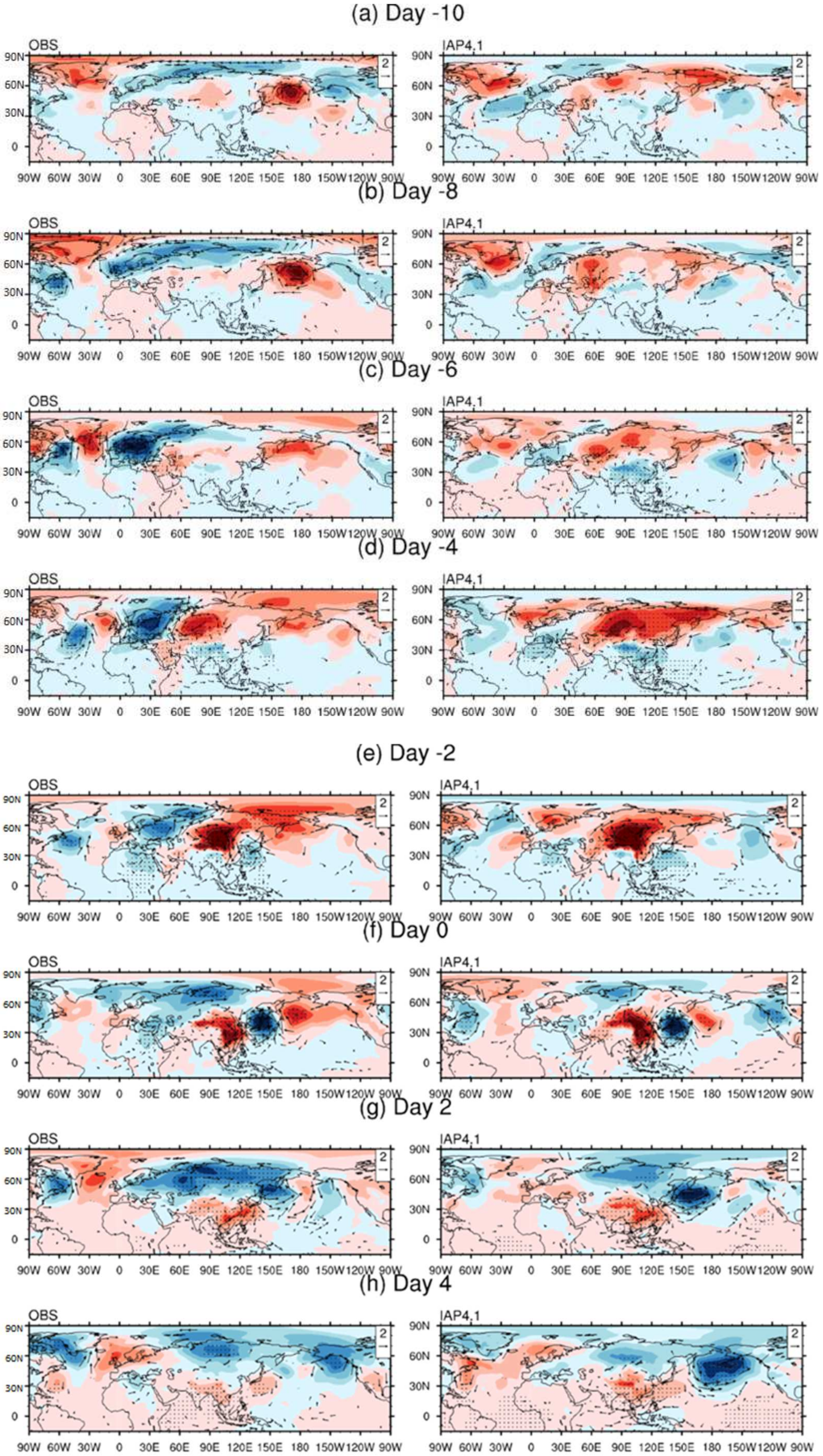
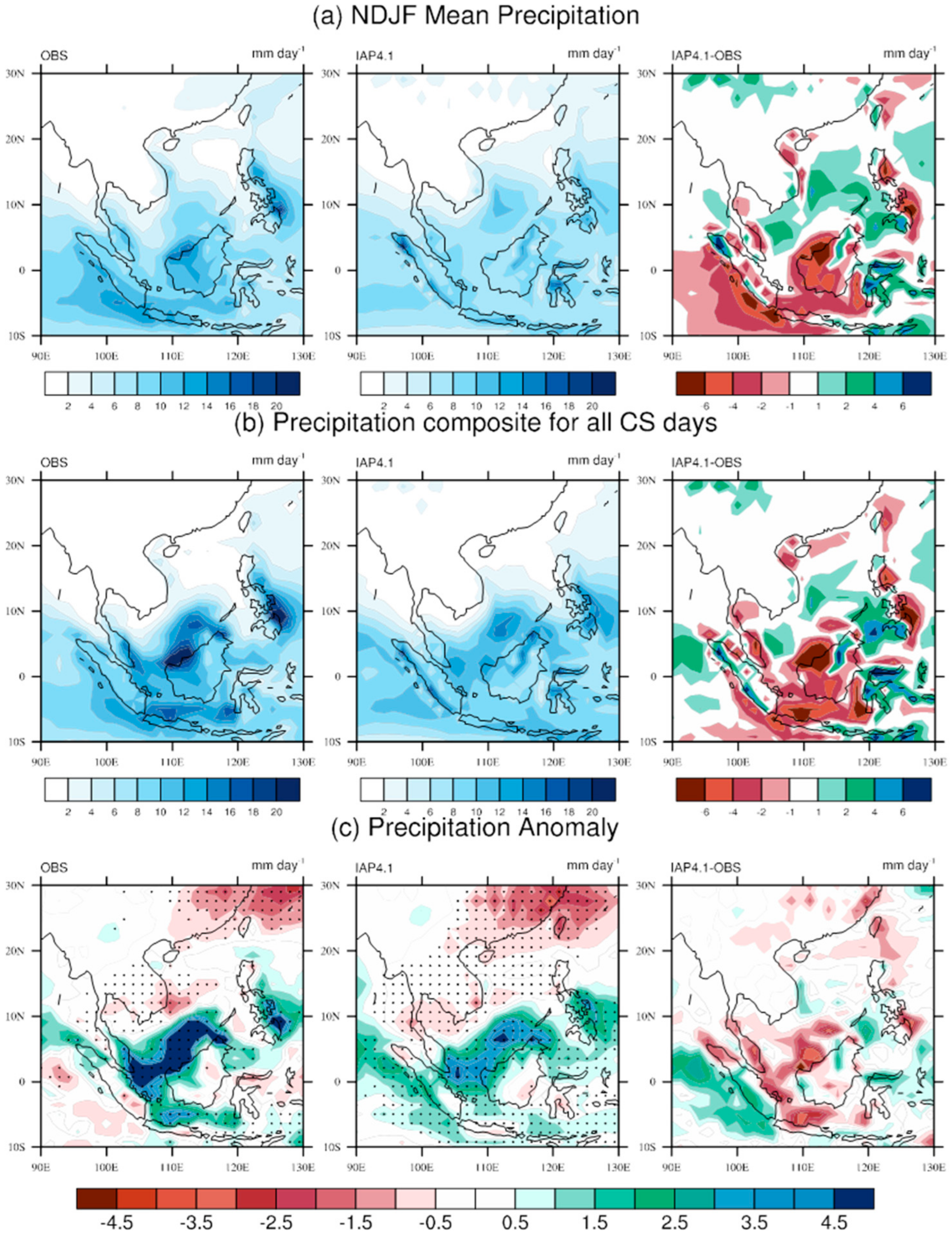
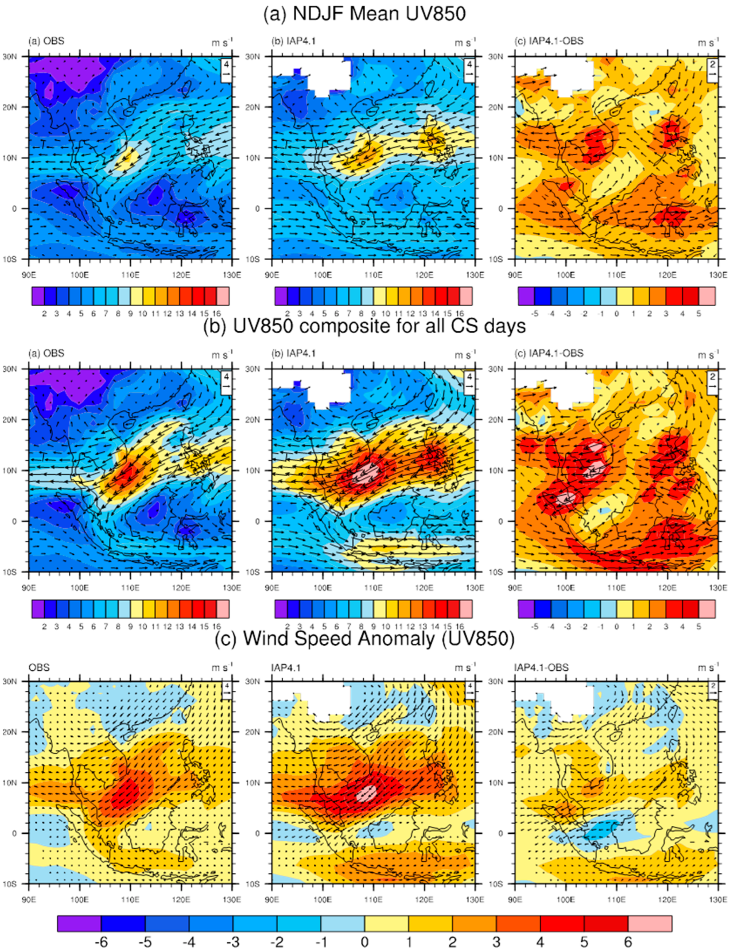
3.2. Rainfall and Circulation Associated with CS Days

CS can influence the local rainfall around SCS and Southeast Asia. We first evaluate the performance of IAP AGCM4.1 in the rainfall and circulation. Considering the climatological mean precipitation in NDJF, IAP AGCM4.1 can reproduce the rainfall centers in central South China Sea (SCS) and along East coast of Philippines (Figure 5a). IAP AGCM4.1 underestimates the rainfall centers near Sumatra and Java Islands and along west coast of Borneo Island, which may be because the model cannot resolve complex topography in the Southeast Asia region [26]. Other factors, such as ENSO, IOD, and MJO, can also influence the precipitation in Southeast Asia and may play a role in the underestimation of precipitation [27]. In addition, the convectively coupled equatorial waves (CCEWs) play an important role in modulating sub-seasonal or intraseasonal convective activity over the MC [28,29,30,31,32]. This bias is also present in many CMIP5 models [33], and investigation into the detailed reasons is desirable in the future.
For CS days, we can see the rainfall pattern is similar to the climatological pattern, indicating that in this region CS event is the main weather system that causes rainfall in late fall and winter seasons. The simulating bias in mean precipitation for CS events is mostly similar to that in mean precipitation for NDJF.
Figure 5c shows the rainfall anomaly associated with CS days calculated from the difference of precipitation between CS days and NDJF climatological mean. Comparing with the NDJF climatological mean, in CS days rainfall increases in southern part of SCS. In addition, there is also a positive rainfall anomalous center along the east coast of the Philippines, thus indicating the two pathways of the CS from mid-to-high latitudes. It is interesting that associated with the positive rainfall centers near the equator, there is a negative rainfall anomalous center in southern China, which can be seen in both observation and IAP AGCM4.1 simulation. This north-south dipole pattern of rainfall may be resulted from the anomalous meridional circulation associated with the CS days [6]. On CS days, the cold air can induce convection in the equatorial region, and thus the prevailing wind is northerly in low level. In the upper-level, however, anomalous southerly can occur associated with the low latitude convection, resulting in a local anomalous meridional circulation. The downward motion branch of this circulation in subtropical can cause the negative rainfall anomaly there. The circulation associated with CS days is shown in Figure 6.
The reanalysis shows that the prevailing wind in Southeast Asia region in winter is northeasterly associated with the East Asia winter monsoon, and the maximum wind velocity center location is in central SCS. IAP AGCM4.1 slightly overestimates the maximum wind velocity center in central SCS and Philippines. In addition, simulated wind direction is east-northeasterly in the central SCS and southern coast of the Indo-China Peninsula, and the magnitude of overestimated easterly component is stronger than that of northerly. This wind direction bias may result in the positive precipitation bias east to Malay/Indo-China Peninsula and negative precipitation bias near the northern coast of Borneo Island, due to the fact that moisture tends to be transported westward (to the Malay Peninsula direction), rather than southward to the Borneo Island (Figure 5). With respect to the CS days, the northeasterly is notably stronger than climatological mean. Overall, IAP AGCM4.1 can reproduce reasonably the pathway that associated with the cold air outbreak from mid-to-high latitudes to Southeast Asian region. However, the wind direction bias (east-northeasterly in simulation, compared to northeasterly in observation) induces more precipitation in central SCS and less precipitation over western Borneo Island and the southern part of SCS.

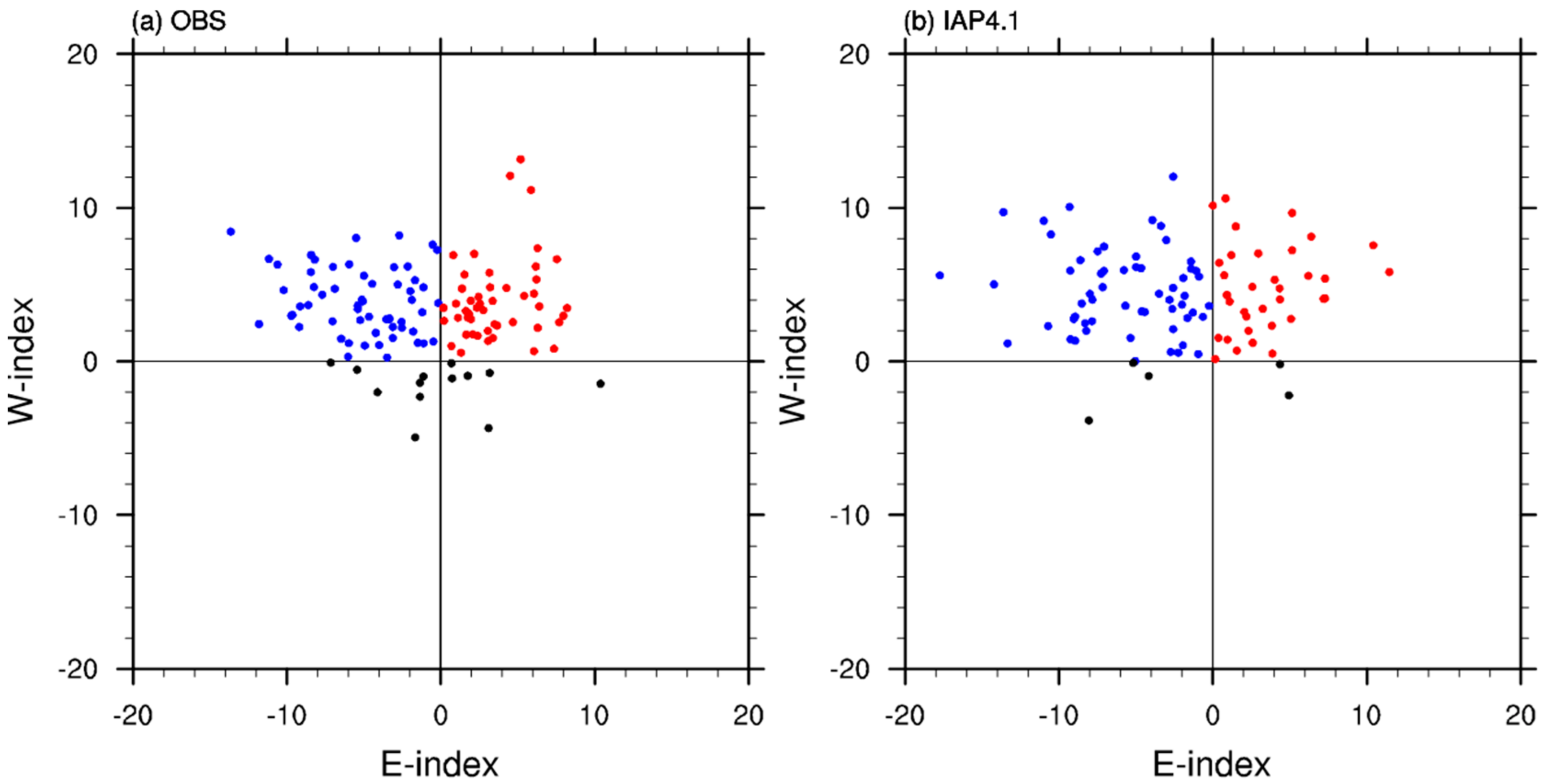
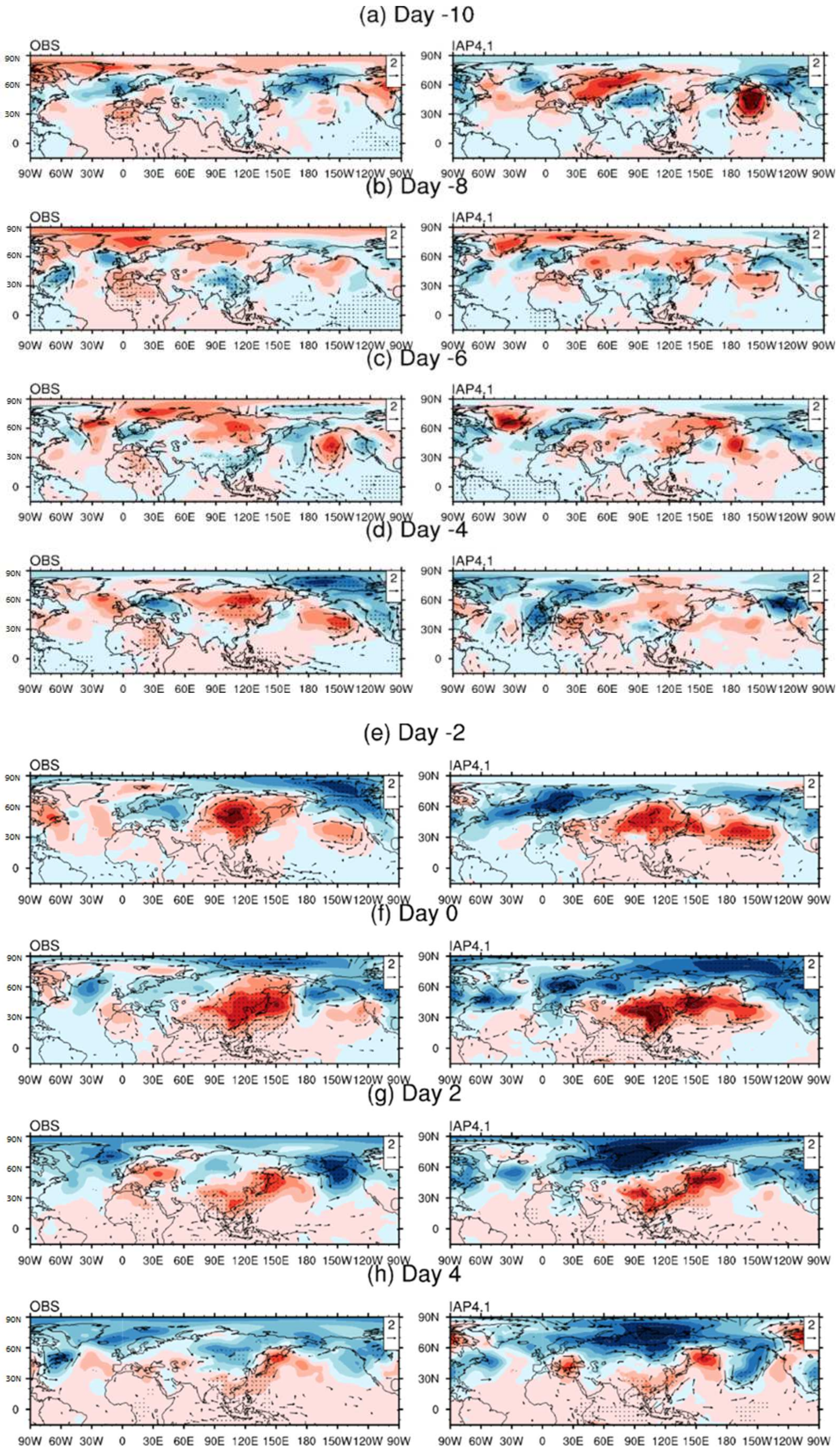
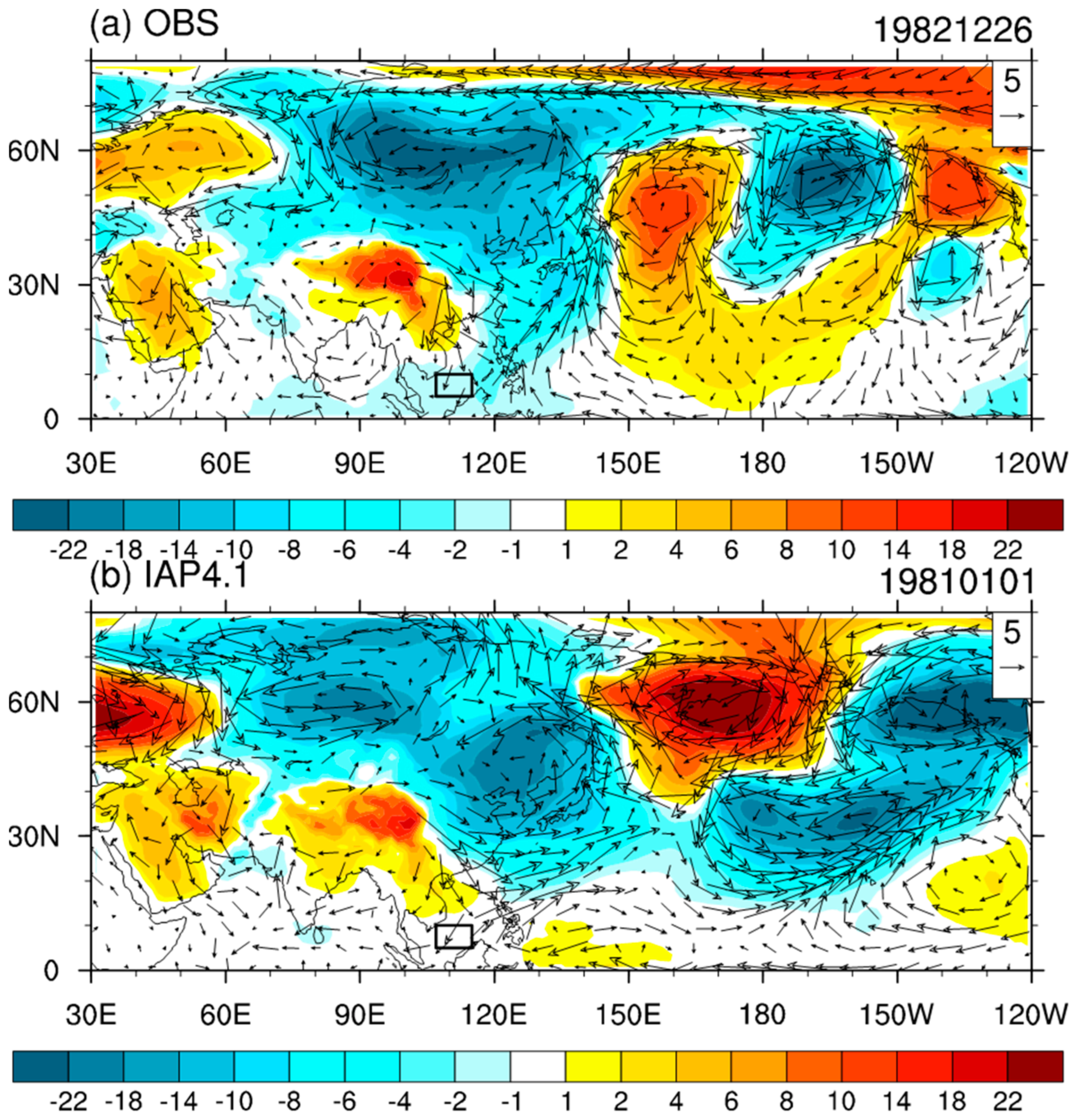
3.3. Negative W-Index Events

According to the above classification, it is interesting that there are fewer events with a negative W-index, illustrated by the black dots in the third and fourth quadrants in Figure 2. There are 13 (5) these events in observation (simulation). Pang and Lu [10] argued that these events tend to be related to tropical circulation anomalies, but they did not investigate further. Figure 7 shows one negative W-index event as a case study. It is obvious that there is negative SLP anomaly in northern part of China and Mongolia, associated with anomalous cyclonic circulation. This is consistent with Figure 2 that the W-index is negative in these events. It is noteworthy that there is a positive SLP anomaly over the Tibetan Plateau, associated with an anomalous anticyclonic circulation. Rather than extending from the east coast of China to the South China Sea in positive W-index events, the northerly wind extends from the eastern part of the Tibetan Plateau in negative W-index events. In these events the northerly anomaly can also meet the criteria for CS events and be regarded as a CS event. In the selected case the simulated circulation pattern is similar to the observation. These events may be triggered by local circulation anomaly around the eastern part of the Tibetan Plateau, which deserves further investigation.

4. Summary and Discussion

In this study the performances of IAP AGCM4.1 in simulation of the CS events in East Asia have been evaluated. In general, the model can capture the key features of anomalous precipitation and circulation associated with the cold surge days. Compared with NDJF climatological mean, the precipitation increases in the southern part of the SCS during CS days, while decreases in the subtropical southern China. In addition, the climatological northeasterly wind over the SCS region strengthens during CS days. In the first day of CS events, there is a dipole pattern in middle latitude East Asia, with positive (negative) sea level pressure (SLP) anomaly in the west (east). Based on the anomalous SLP signs in the two centers of the dipole pattern, the CS days can be further classified into two types, positive-west–negative-east-type, and positive-west–positive-east-type. These features can be reasonably reproduced by IAP AGCM4.1.
Due to the lower resolution in the SCS and Southeast Asia region, there are inevitable biases in the simulation. For instance, the model underestimates (overestimated) the precipitation in west and south parts of the Borneo Island and along the Indonesia Islands (to the east coasts of Malay Peninsula and Indo China Peninsula, around the Sulawesi/Celebes Island, to the west coast of the Mindanao Island). In addition, the prevailing northeasterly wind over SCS region in boreal winter is overestimated, with an east-northeast direction bias in the model. The simulated number of CS days is slightly underestimated in simulation. We think the lower resolution is an important factor that contribute to the bias in Southeast Asian region, due to that the land-sea distribution is complex in the Maritime Continent. Thus the 1.4° × 1.4° horizontal resolution in IAP AGCM4.1 is not enough to resolve the complex terrain there, which may result in the precipitation and wind bias. We are now developing a higher resolution version of IAP AGCM (~0.5° × 0.5°). Whether the bias can be reduced in higher resolution models deserves further exploration.
Although, on most CS days, there is positive SLP anomaly in the East China region, there are much less events with a negative SLP anomaly there. This type of CS days is further discussed as a case study. In these events, the northerly anomaly in SCS is associated with an anticyclonic circulation anomaly around the eastern part of the Tibetan Plateau, rather than extending from the mid-to-high latitude cold air outbreaks. This type of CS days and associated circulation feature can be captured by the model. Our study implied that IAP AGCM4.1 is a useful tool in simulating and predicting the CS events and its associated circulation. Developing a seasonal prediction system using stand-alone IAP AGCM4.1 or coupled CAS-ESM is expected.
In this study, the methods of Lim et al. [11] and Pang and Lu [10] were adopted to evaluate the performances of IAP AGCM4.1 in the simulation of the CS events. The above two studies are observational explorations and focus on the processes and mechanisms, regarding how CS events occur, based on observation and reanalysis datasets. Different from them, our study focused on evaluation of IAP AGCM4.1. It should also be noted that the simulation period was from 1979 to 2005, and the available reanalysis dataset can be updated to 2018. We think the main features of the CS events are comparable between simulation and reanalysis although the time range is different. Nevertheless, the decadal variation of the CS events may also induce inconsistency between the simulation and observation if CS in different time periods were compared. Whether there is a low frequency variation of the main features of CS (e.g., decadal or multidecadal variability) deserves further investigation.

Author Contributions

Conceptualization, R.L. and X.D.; methodology, R.L.; software, R.L.; validation, R.L. and X.D.; formal analysis, R.L.; investigation, R.L. and X.D.; writing—original draft preparation, R.L.; writing—review and editing, R.L., X.D., H.Z., C.W., and J.J. All authors have read and agreed to the published version of the manuscript.

Funding

This research was jointly supported by the Key Research Program of Frontier Sciences, Chinese Academy of Sciences (ZDBS-LY-DQC010), and Youth Innovation Promotion Association of CAS (2022074). The numerical experiment is conducted at “Earth System Science Numerical Simulator Facility” (EarthLab), which is supported by the National Key Scientific and Technological Infrastructure project.

Institutional Review Board Statement

Not applicable.

Informed Consent Statement

Not applicable.

Data Availability Statement

Not applicable.

Acknowledgments

We thank the National Key Scientific and Technological Infrastructure project, entitled “Earth System Science Numerical Simulator Facility” (EarthLab), for providing the environment to run the experiments.

Conflicts of Interest

The authors declare no conflict of interest.

References

  1. Compo, G.P.; Kiladis, G.N.; Webster, P.J. The horizontal and vertical structure of east Asian winter monsoon pressure surges. Q. J. R. Meteorol. Soc. 1999, 125, 29–54. [Google Scholar] [CrossRef]
  2. Hong, C.-C.; Li, T. The Extreme Cold Anomaly over Southeast Asia in February 2008: Roles of ISO and ENSO*. J. Clim. 2009, 22, 3786–3801. [Google Scholar] [CrossRef]
  3. Huang, J.; Tian, W. Eurasian Cold Air Outbreaks under Different Arctic Stratospheric Polar Vortex Strengths. J. Atmos. Sci. 2019, 76, 1245–1264. [Google Scholar] [CrossRef]
  4. Lubis, S.W.; Huang, C.S.Y.; Nakamura, N.; Omrani, N.-E.; Jucker, M. Role of Finite-Amplitude Rossby Waves and Nonconservative Processes in Downward Migration of Extratropical Flow Anomalies. J. Atmos. Sci. 2018, 75, 1385–1401. [Google Scholar] [CrossRef]
  5. Nabizadeh, E.; Lubis, S.W.; Hassanzadeh, P. The 3D structure of northern hemisphere blocking events: Climatology, role of moisture, and response to climate change. J. Clim. 2021, 34, 249–267. [Google Scholar] [CrossRef]
  6. Zhao, S.X.; Zeng, Q.C. A Study of East Asia Strong Cold Wave Surge Crossing Equator and Influencing the Development of Tropical Cyclone and Heavy Rainfall in the Southern Hemisphere. Clim. Environ. Res. 2005, 10, 507–525. (In Chinese) [Google Scholar] [CrossRef]
  7. Sun, Y.; Hu, T.; Zhang, X.; Wan, H.; Stott, P.; Lu, C. Anthropogenic Influence on the Eastern China 2016 Super Cold Surge. Bull. Am. Meteorol. Soc. 2018, 99, S123–S127. [Google Scholar] [CrossRef] [Green Version]
  8. Jiang, Q.; Ma, X.K.; Wang, F. Analysis of the January 2016 atmospheric circulation and weather. Meteorol. Mon. 2016, 42, 514–520. (In Chinese) [Google Scholar] [CrossRef]
  9. Song, L.; Wu, R. Processes for Occurrence of Strong Cold Events over Eastern China. J. Clim. 2017, 30, 9247–9266. [Google Scholar] [CrossRef]
  10. Pang, B.; Lu, R. Two Distinct Types of Extratropical Circulation Anomalies Associated with Cold Surges over the South China Sea. J. Clim. 2019, 32, 5069–5084. [Google Scholar] [CrossRef]
  11. Lim, S.Y.; Marzin, C.; Xavier, P.; Chang, C.-P.; Timbal, B. Impacts of Boreal Winter Monsoon Cold Surges and the Interaction with MJO on Southeast Asia Rainfall. J. Clim. 2017, 30, 4267–4281. [Google Scholar] [CrossRef]
  12. Park, T.-W.; Heo, J.-W.; Jeong, J.-H.; Ho, C.-H. Characteristics of East Asian Cold Surges in the CMIP5 Climate Models. Atmos. Kerean Meteorol. Soc. 2017, 27, 199–211. [Google Scholar]
  13. Mailler, S.; Lott, F. Dynamical influence of the Tibetan Plateau on the winter monsoon over southeastern Asia. Geophys. Res. Lett. 2009, 36. [Google Scholar] [CrossRef] [Green Version]
  14. Zhang, H.; Zhang, M.; Zeng, Q.-C. Sensitivity of Simulated Climate to Two Atmospheric Models: Interpretation of Differences between Dry Models and Moist Models. Mon. Weather Rev. 2013, 141, 1558–1576. [Google Scholar] [CrossRef]
  15. Zhang, H.; Zhang, M.; Jin, J.; Fei, K.; Ji, D.; Wu, C.; Zhu, J.; He, J.; Chai, Z.; Xie, J.; et al. CAS-ESM2: Description and Climate Simulation Performance of the Chinese Academy of Sciences (CAS) Earth System Model (ESM) Version 2.0. J. Adv. Modeling Earth Syst. 2020, 12, e2020MS002210. [Google Scholar]
  16. Neale, R.B.; Gettelman, A.; Park, S.; Chen, C.-C.; Lauritzen, P.H.; Williamson, D.L.; Conley, A.J.; Garcia, R.; Kinnison, D.; Lamarque, J.F.; et al. Description of the NCAR Community Atmosphere Model (CAM 5.0) (No. NCAR/TN-486+STR); UCAR: Boulder, CO, USA, 2012. [Google Scholar] [CrossRef]
  17. Dong, X.; Xue, F.; Zhang, H.; Zeng, Q. Evaluation of Surface Air Temperature Change over China and the Globe during the Twentieth Century in IAP AGCM4.0. Atmos. Ocean. Sci. Lett. 2012, 5, 435–438. [Google Scholar] [CrossRef] [Green Version]
  18. Dong, X.; Su, T.; Wang, J.; Lin, R. Decadal variation of the Aleutian Low-Icelandic Low seesaw simulated by a climate system model (CAS-ESM-C). Atmos. Ocean. Sci. Lett. 2014, 7, 110–114. [Google Scholar]
  19. Dong, X.; Xue, F. Phase transition of the Pacific decadal oscillation and decadal variation of the East Asian summer monsoon in the 20th century. Adv. Atmos. Sci. 2016, 33, 330–338. [Google Scholar] [CrossRef]
  20. Su, T.; Xue, F.; Zhang, H. Simulating the Intraseasonal Variation of the East Asian Summer Monsoon by IAPAGCM4.0. Adv. Atmos. Sci. 2014, 31, 570–580. [Google Scholar] [CrossRef]
  21. Yan, Z.; Lin, Z.; Zhang, H. The Relationship between the East Asian Subtropical Westerly Jet and Summer Precipitation over East Asia as Simulated by the IAP AGCM4.0. Atmos. Ocean. Sci. Lett. 2014, 7, 487–492. [Google Scholar] [CrossRef]
  22. Zhou, Y.; Zhang, H.; Zhang, K.W. Evaluation of the Simulated Tropical Cyclones over the Western North Pacific with IAP AGCM4.1 Based on K-means Method. Chin. J. Atmos. Sci. 2020, 44, 1141–1154. (In Chinese) [Google Scholar] [CrossRef]
  23. Gates, W.L. AMIP: The Atmospheric Model Intercomparison Project. Bull. Am. Meteorol. Soc. 1992, 73, 1962–1970. [Google Scholar] [CrossRef] [Green Version]
  24. Milinski, S.; Maher, N.; Olonscheck, D. How large does a large ensemble need to be? Earth Syst. Dyn. 2020, 11, 885–901. [Google Scholar] [CrossRef]
  25. Dee, D.P.; Uppala, S.M.; Simmons, A.J.; Berrisford, P.; Poli, P.; Kobayashi, S.; Andrae, U.; Balmaseda, M.A.; Balsamo, G.; Bauer, P.; et al. The ERA-Interim reanalysis: Configuration and performance of the data assimilation system. Q. J. R. Meteorol. Soc. 2011, 137, 553–597. [Google Scholar] [CrossRef]
  26. Zhang, T.; Tam, C.-Y.; Jiang, X.; Yang, S.; Lau, N.-C.; Chen, J.; Laohalertchai, C. Roles of land-surface properties and terrains on Maritime Continent rainfall and its seasonal evolution. Clim. Dyn. 2019, 53, 6681–6697. [Google Scholar] [CrossRef]
  27. Islam, M.; Chan, A.; Ashfold, M.; Ooi, C.; Azari, M. Effects of El-Niño, Indian Ocean Dipole, and Madden-Julian Oscillation on Surface Air Temperature and Rainfall Anomalies over Southeast Asia in 2015. Atmosphere 2018, 9, 352. [Google Scholar] [CrossRef] [Green Version]
  28. Lubis, S.W.; Jacobi, C. The modulating influence of convectively coupled equatorial waves (CCEWs) on the var-iability of tropical precipitation. Int. J. Climatol. 2015, 35, 1465–1483. [Google Scholar] [CrossRef]
  29. Sakaeda, N.; Kiladis, G.; Dias, J. The Diurnal Cycle of Rainfall and the Convectively Coupled Equatorial Waves over the Maritime Continent. J. Clim. 2020, 33, 3307–3331. [Google Scholar] [CrossRef]
  30. Peatman, S.C.; Schwendike, J.; Birch, C.E.; Marsham, J.H.; Matthews, A.J.; Yang, G. A Local-to-Large scale view of Maritime Continent rainfall: Control by ENSO, MJO, and equatorial waves. J. Clim. 2021, 34, 8933–8953. [Google Scholar] [CrossRef]
  31. Lubis, S.W.; Respati, M.R. Impacts of convectively coupled equatorial waves on rainfall extremes in Java, Indonesia. Int. J. Climatol. 2020, 41, 2418–2440. [Google Scholar] [CrossRef]
  32. Muhammad, F.R.; Lubis, S.W.; Setiawan, S. Impacts of the Madden–Julian oscillation on precipitation extremes in Indonesia. Int. J. Climatol. 2021, 41, 1970–1984. [Google Scholar] [CrossRef]
  33. Raghavan, S.V.; Liu, J.; Nguyen, N.S.; Vu, M.T.; Liong, S.-Y. Assessment of CMIP5 historical simulations of rainfall over Southeast Asia. Arch. Meteorol. Geophys. Bioclimatol. Ser. B 2017, 132, 989–1002. [Google Scholar] [CrossRef]
Figure 1. The first day composite of (a) SLP anomaly (shaded) and wind field anomaly at 850-hPa (vectors), (b) geopotential height anomaly (shaded), (c) zonal wind anomaly at 200-hPa (shaded) and (d) air temperature anomaly at 850-hPa (shaded) for all CS events in observation (left panels) and IAP AGCM4.1 simulation (right panels). The corresponding climatology in observation and simulation are also shown in (b,c) as contours. The dotted denotes regions that are significant at 95% confidence level, based on student-t test. The black box in (a) is the region (15° N–45° N, 110° E–120° E) and (25° N–45° N, 135° E–150° E). The boxes in (a) indicate the regions used to define the western and eastern indices (the W-index and E-index, respectively).
Atmosphere 13 01176 g001
Figure 2. Scatterplot of the standardized W-index vs the E-index in (a) observation and (b) simulation. The blue and red dots denote negative and positive cold surges, respectively, based on the sign of the E-index. The black dots denote events with a negative W-index.
Atmosphere 13 01176 g002
Figure 3. Composite SLP and 925-hPa wind for negative CS events in observation (left panels) and simulation (right panels). The evolutions of the composite circulations associated with CS events are shown in each subplot from (a) Day 10 before the first day of CS events to (h) Day 4 after it.
Atmosphere 13 01176 g003
Figure 4. The evolutions of the composite circulations associated with positive CS events are shown in each subplot from (a) Day 10 before the first day of CS events to (h) Day 4 after it.
Atmosphere 13 01176 g004
Figure 5. (a) climatological NDJF mean precipitation (Units: mm/day), (b) precipitation composite for CS days, (c) b minus a. Observation and simulation are shown in the left and middle columns, respectively. The right column is simulation minus observation. In (c) the dotted denotes regions that are significant at 95% confidence level based on student-t test.
Atmosphere 13 01176 g005
Figure 6. The same as Figure 3, but for wind field at 850-hPa (vectors, Units: m/s) and corresponding wind speed (shaded).
Atmosphere 13 01176 g006
Figure 7. The SLP (shaded) and wind field anomalies at 850-hPa (vectors) on the first day of a negative W-index event in (a) observation and (b) simulation. The selected case in observation (simulation) was 26 December 1982 (1 January 1981).
Atmosphere 13 01176 g007
Table 1. Information and statistics of observed and simulated cold surge days and events.
Time PeriodFull DefinitionCS Definition without SLP LimitationCS Definition without Meridional Wind LimitationCS Definition without Zonal Wind Limitation
ObservationIAP4.1ObsIAP4.1ObsIAP4.1ObsIAP4.1
NDJF 1979–2005
Vclm (m/s)8.078.658.078.658.078.658.078.65
Vstd (m/s)2.953.582.953.582.953.582.953.58
Vmin (m/s)10.2811.3410.2811.3410.2811.3410.2811.34
CS days619489701641619508628490
CS events1209713210812010212097
AD (days)5.184.935.525.975.184.905.284.93
D10 (days)1071317107117
Vclm: climatological velocity; Vstd: velocity standard deviation; Vmin: minimum velocity to be regarded as a cold surge day; AD: averaged duration of a cold surge event; D10: CS events with duration of at least 10 days.
Publisher’s Note: MDPI stays neutral with regard to jurisdictional claims in published maps and institutional affiliations.

