
Topographical and Thermal Forcing in Favorable Circulation Pattern to Early Spring Precipitation over the Southeastern Tibetan Plateau

 and
and
Abstract
:1. Introduction
2. Model Experiments, Data, and Methods
2.1. Model Experiments and Data
2.2. Analysis Methods
3. Results
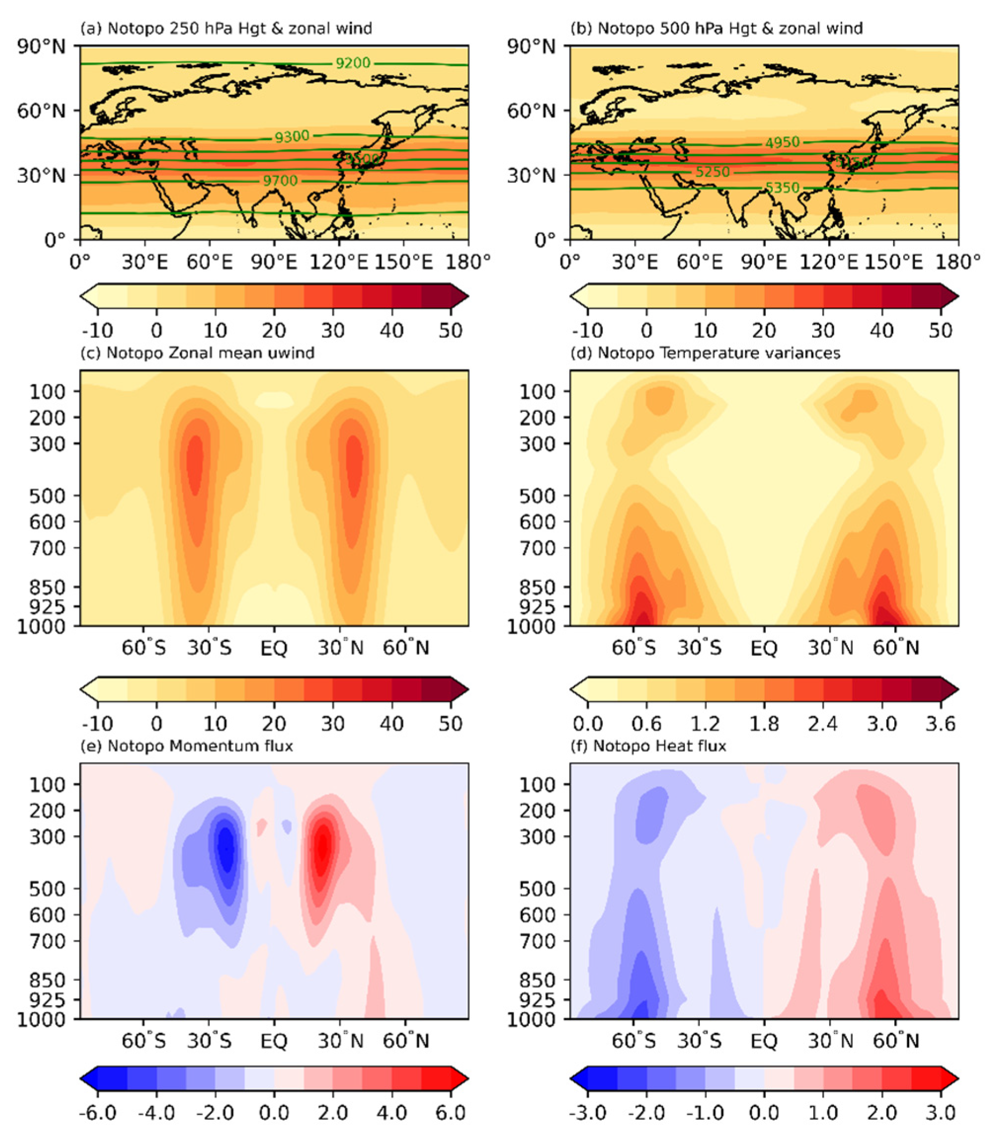
3.1. Simulated Zonal-Mean Circulation
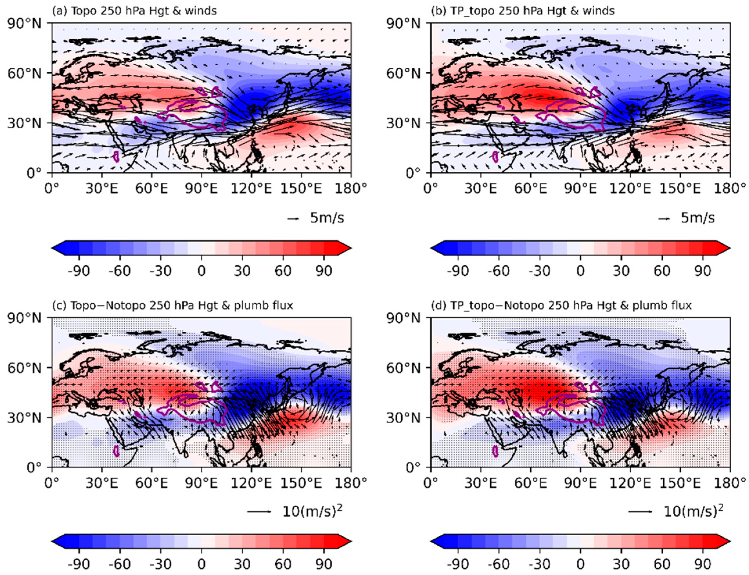
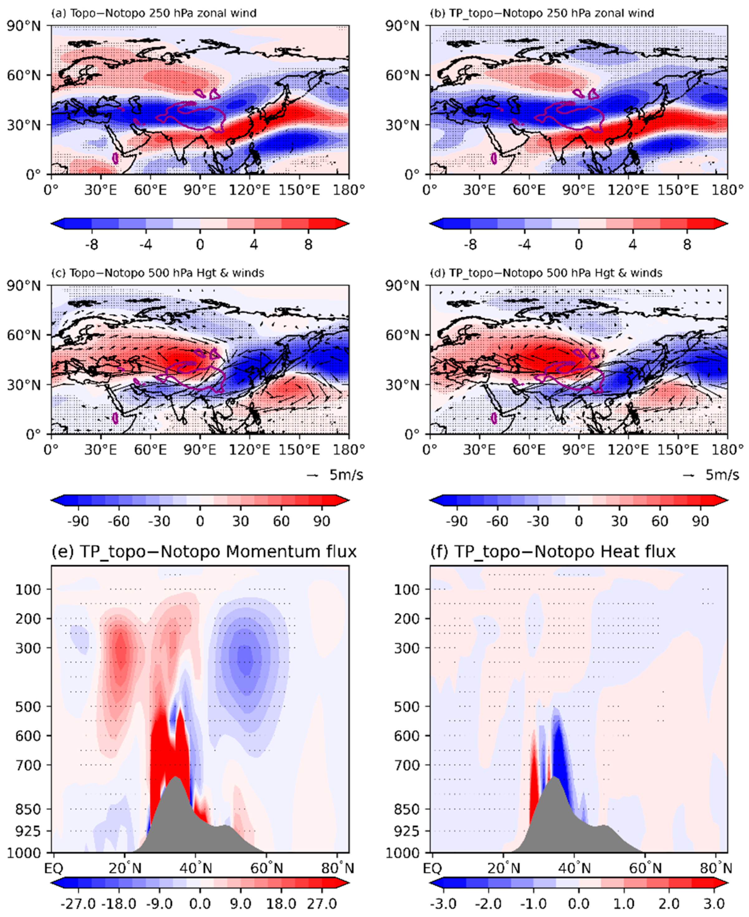
3.2. Topographic Effects on the Atmospheric Circulation and Planetary Wave Propagation
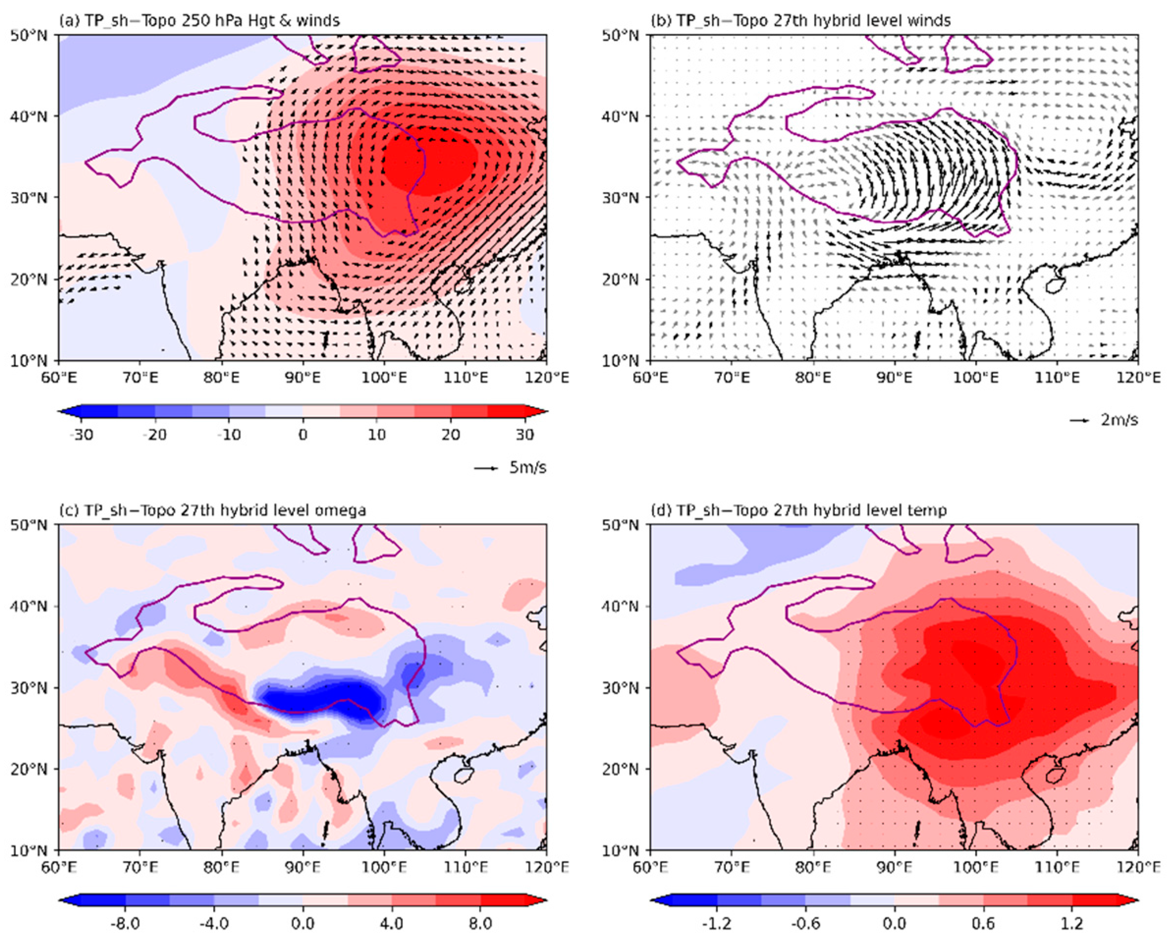
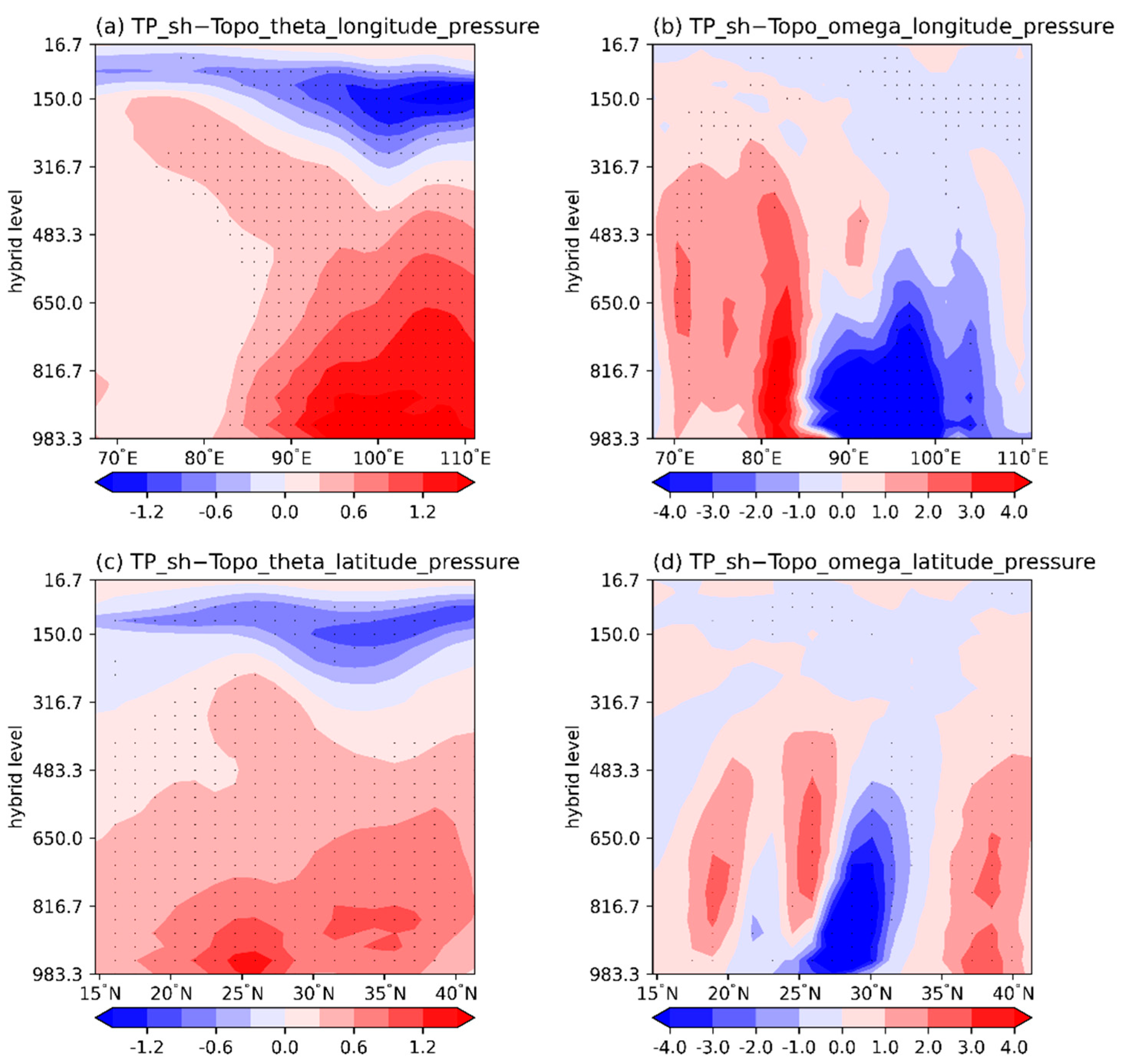
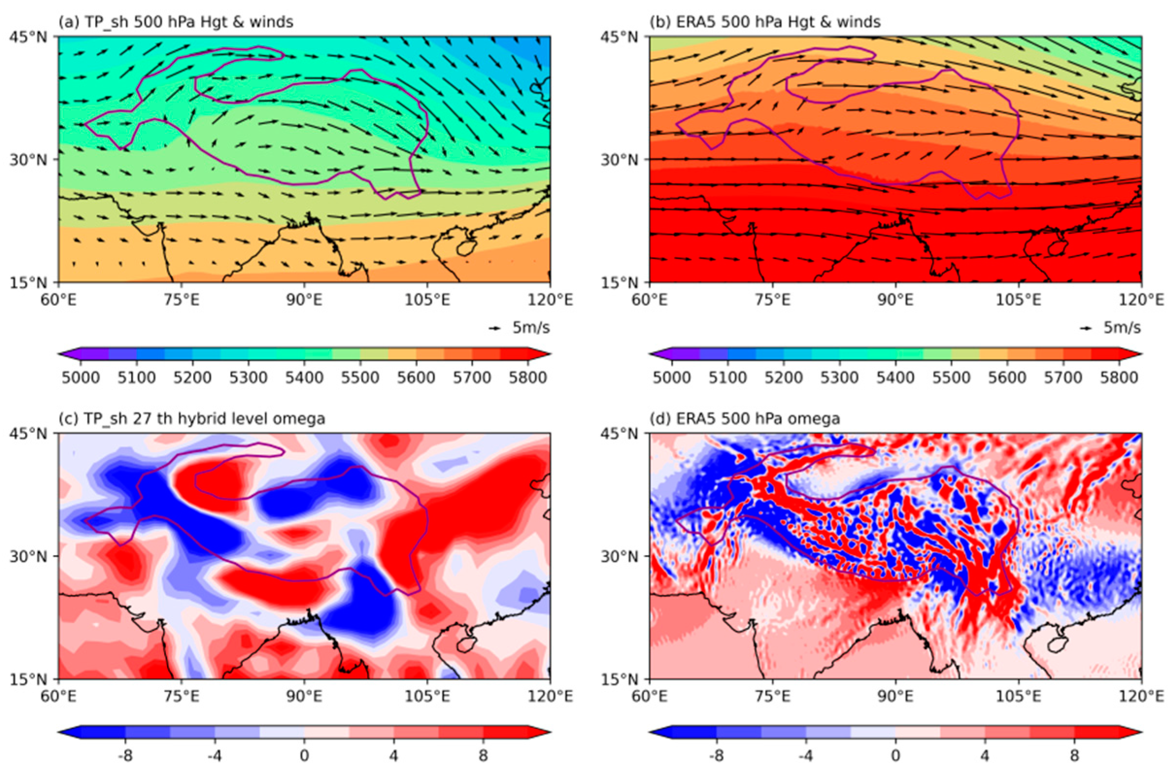
3.3. Thermal Effects on the Atmospheric Circulation
4. Conclusions and Discussion
Author Contributions
Funding
Institutional Review Board Statement
Informed Consent Statement
Data Availability Statement
Acknowledgments
Conflicts of Interest
References
- Xu, X.; Lu, C.; Shi, X.; Gao, S. World water tower: An atmospheric perspective. Geophys. Res. Lett. 2008, 35, L20815. [Google Scholar] [CrossRef]
- He, Y.; Tian, W.; Huang, J.; Wang, G.; Ren, Y.; Yan, H.; Yu, H.; Guan, X.; Hu, H. The mechanism of increasing summer water vapor over the Tibetan Plateau. J. Geophys. Res. Atmos. 2021, 126, e2020JD034166. [Google Scholar] [CrossRef]
- Liu, L.; Ma, Y.; Yao, N.; Ma, W. Diagnostic analysis of a regional heavy snowfall event over the Tibetan Plateau using NCEP reanalysis data and WRF. Clim. Dyn. 2008, 56, 2451–2467. [Google Scholar] [CrossRef]
- Wu, G.; Liu, Y.; Zhang, Q.; Duan, A.; Wang, T.; Wan, R.; Liu, X.; Li, W.; Wang, Z.; Liang, X. The influence of mechanical and thermal forcing by the Tibetan Plateau on Asian climate. J. Hydrometeorol. 2007, 8, 770–789. [Google Scholar] [CrossRef] [Green Version]
- Wu, G.; Liu, Y.; He, B.; Bao, Q.; Duan, A.; Jin, F.-F. Thermal controls on the Asian summer monsoon. Sci. Rep. 2012, 2, 404. [Google Scholar] [CrossRef] [Green Version]
- Zhao, Y.; Duan, A.; Wu, G. Interannual variability of late-spring circulation and diabatic heating over the Tibetan Plateau associated with Indian Ocean forcing. Adv. Atmos. Sci. 2018, 35, 927–941. [Google Scholar] [CrossRef]
- Kuang, X.; Zhang, Y. Seasonal Variation of the East Asian subtropical Westerly Jet and Its association with heating fields over East Asia. Adv. Atmos. Sci. 2005, 22, 831–840. [Google Scholar]
- Liu, X.; Liu, Y.; Wang, X.; Wu, G. Large- scale dynamics and moisture sources of the precipitation over the western Tibetan Plateau in boreal winter. J. Geophys. Res. Atmos. 2020, 125, e2019JD032133. [Google Scholar] [CrossRef]
- Yang, K.; Wu, H.; Qin, J.; Lin, C.; Tang, W.; Chen, Y. Recent climate changes over the Tibetan Plateau and their impacts on energy and water cycle: A review. Glob. Planet. Change 2014, 112, 79–91. [Google Scholar] [CrossRef]
- Ouyang, L.; Yang, K.; Lu, H.; Chen, Y.; La, Z.; Zhou, X.; Wang, Y. Ground based observations reveal unique valley precipitation patterns in the central Himalaya. J. Geophys. Res. Atmos. 2020, 125, e2019JD031502. [Google Scholar] [CrossRef]
- Xiao, Z.; Duan, A. Impacts of Tibetan Plateau snow cover on the interannual variability of the East Asian summer monsoon. J. Clim. 2016, 29, 8495–8514. [Google Scholar] [CrossRef]
- Duan, A.; Xiao, Z.; Wang, Z. Impacts of the Tibetan Plateau winter/spring snow depth and surface heat source on Asian summer monsoon: A review. Chin. J. Atmos. Sci. 2018, 42, 755–766. (In Chinese) [Google Scholar]
- Han, Y.; Ma, W.; Yang, Y.; Ma, Y.; Xie, Z.; Sun, G.; Menenti, M.; Su, B. Impacts of the Silk Road pattern on the interdecadal variations of the atmospheric heat source over the Tibetan Plateau. Atmos. Res. 2021, 260, 105696. [Google Scholar] [CrossRef]
- Bolin, B. On the influence of the earth’s orography on the general character of the westerlies. Tellus 1950, 2, 184–195. [Google Scholar] [CrossRef]
- Yeh, T. The circulation of the high troposphere over China in the winter of 1945–1946. Tellus 1950, 2, 173–183. [Google Scholar] [CrossRef] [Green Version]
- Zhou, X.; Gu, Z. The influence of the slope of a plateau on the movement of troughs and ridges. Acta Meteorol. Sin. 1958, 29, 99–103. (In Chinese) [Google Scholar]
- Duan, A.; Liu, S.; Zhao, Y.; Gao, K.; Hu, W. Atmospheric heat source/sink dataset over the Tibetan Plateau based on satellite and routine meteorological observations. Big Earth Data 2018, 2, 179–189. [Google Scholar] [CrossRef] [Green Version]
- Wan, R.; Wu, G. Mechanism of the Spring Persistent Rains over southeastern China. Sci. China Earth Sci. 2007, 50, 130–144. [Google Scholar] [CrossRef]
- Ren, R.; Xia, X.; Rao, J. Topographic forcing from East Asia and North America in the northern winter stratosphere and their mutual interference. J. Clim. 2019, 32, 8639–8658. [Google Scholar] [CrossRef]
- Held, I.; Suarez, M. A proposal for the intercomparison of the dynamical cores of atmospheric general circulation models. Bull. Am. Meteorol. Soc. 1994, 75, 1825–1830. [Google Scholar] [CrossRef] [Green Version]
- Schneider, T.; Bordoni, S. Eddy-mediated regime transitions in the seasonal cycle of a Hadley circulation and implications for monsoon dynamics. J. Atmos. Sci. 2008, 65, 915–934. [Google Scholar] [CrossRef] [Green Version]
- Siu, L.; Bowman, K. Forcing of the upper-tropospheric monsoon anticyclones. J. Atmos. Sci. 2019, 76, 1937–1954. [Google Scholar] [CrossRef]
- Schneider, T. The tropopause and the thermal stratification in the extratropics of a dry atmosphere. J. Atmos. Sci. 2004, 61, 1317–1340. [Google Scholar] [CrossRef] [Green Version]
- Kobayashi, S.; Ota, Y.; Harada, Y.; Ebita, A.; Moriya, M.; Onoda, H.; Onogi, K.; Kamahori, H.; Kobayashi, C.; Endo, H.; et al. The JRA-55 Reanalysis: General Specifications and Basic Characteristics. J. Meteorol. Soc. Jpn. 2015, 93, 5–48. [Google Scholar] [CrossRef] [Green Version]
- Sardeshmukh, P.; Hoskins, B. Spatial Smoothing on the Sphere. Mon. Weather Rev. 1984, 112, 2524–2529. [Google Scholar] [CrossRef] [Green Version]
- Hersbach, H.; Bell, B.; Berrisford, P.; Hirahara, S.; Horányi, A.; Muñoz-Sabater, J.; Nicolas, J.; Peubey, C.; Radu, R.; Schepers, D.; et al. The ERA5 global reanalysis. Q. J. R. Meteorol. Soc. 2020, 146, 1999–2049. [Google Scholar] [CrossRef]
- Plumb, R. On the three-dimensional propagation of stationary waves. J. Atmos. Sci. 1985, 42, 217–229. [Google Scholar] [CrossRef]
- Andrews, D.; McIntyre, M. Planetary Waves in Horizontal and Vertical Shear: The Generalized Eliassen-Palm Relation and the Mean Zonal Acceleration. J. Atmos. Sci. 1976, 33, 2031–2048. [Google Scholar] [CrossRef] [Green Version]
- Wu, G.; Liu, Y. Thermal adaptation, overshooting, dispersion, and surbtropical high. Part I: Thermal adaptation and overshooting. Chin. J. Atmos. Sci. 2000, 24, 433–446. (In Chinese) [Google Scholar]


| Experiment Name | Experiment Configuration |
|---|---|
| Notopo | Without terrain and radiative forcing. |
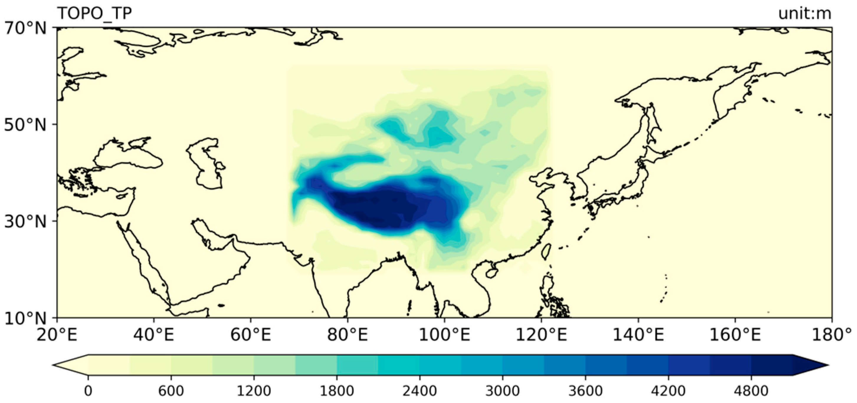
| TP_topo | With realistic terrain over 70.3° E~120.9° E, 21.7° N~60.9° N and radiative forcing. |
| Topo | With realistic terrain radiative forcing. |
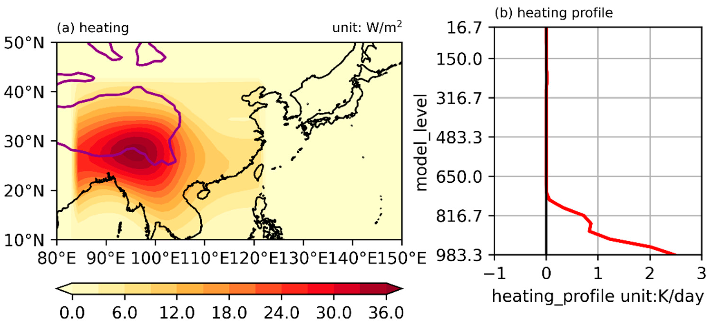
| TP_sh | With realistic terrain, radiative frocing, and vertical diffusion heating over the Tibetan Plateau and its surrounding areas. |
Publisher’s Note: MDPI stays neutral with regard to jurisdictional claims in published maps and institutional affiliations. |
© 2022 by the authors. Licensee MDPI, Basel, Switzerland. This article is an open access article distributed under the terms and conditions of the Creative Commons Attribution (CC BY) license (https://creativecommons.org/licenses/by/4.0/).
Share and Cite
Yang, Y.; Hu, Z.; Li, M.; Yu, H.; Ma, W.; Fan, W. Topographical and Thermal Forcing in Favorable Circulation Pattern to Early Spring Precipitation over the Southeastern Tibetan Plateau. Atmosphere 2022, 13, 973. https://doi.org/10.3390/atmos13060973
Yang Y, Hu Z, Li M, Yu H, Ma W, Fan W. Topographical and Thermal Forcing in Favorable Circulation Pattern to Early Spring Precipitation over the Southeastern Tibetan Plateau. Atmosphere. 2022; 13(6):973. https://doi.org/10.3390/atmos13060973
Chicago/Turabian StyleYang, Yaoxian, Zeyong Hu, Maoshan Li, Haipeng Yu, Weiqiang Ma, and Weiwei Fan. 2022. "Topographical and Thermal Forcing in Favorable Circulation Pattern to Early Spring Precipitation over the Southeastern Tibetan Plateau" Atmosphere 13, no. 6: 973. https://doi.org/10.3390/atmos13060973