Article

Aerosol Retrieval over Land from the Directional Polarimetric Camera Aboard on GF-5

1
Key Laboratory of Space Weather, National Satellite Meteorological Center (National Center for Space Weather), China Meteorological Administration, Beijing 100081, China
2
Innovation Center for FengYun Meteorological Satellite (FYSIC), Beijing 100081, China
3
Department of Geographical Sciences, University of Maryland, 2181 Samuel J. LeFrak Hall, 7251 Preinkert Drive, College Park, MD 20742, USA
4
China Center for Resources Satellite Data and Application, Beijing 100094, China
5
Anhui Institute of Optics and Fine Mechanics, Chinese Academy of Sciences, Hefei 230031, China
*
Authors to whom correspondence should be addressed.
Atmosphere 2022, 13(11), 1884; https://doi.org/10.3390/atmos13111884
Submission received: 29 September 2022 / Revised: 1 November 2022 / Accepted: 6 November 2022 / Published: 11 November 2022
(This article belongs to the Section Atmospheric Techniques, Instruments, and Modeling)

Abstract

:
The DPC (Directional Polarization Camera) onboard the Chinese GaoFen-5 (GF-5) satellite is the first operational aerosol monitoring instrument capable of performing multi-angle polarized measurements in China. Compared with POLDER (Polarization and Directionality of Earth’s Reflectance) which ended its mission in December 2013, DPC has similar band design, with a maximum of 12 imaging angles and a relatively higher spatial resolution of 3.3 km. The global aerosol optical depth (AOD) over land from October to December in 2018 was retrieved with multi-angle polarization measurements of DPC. Comparisons with MODIS (Moderate Resolution Imaging Spectroradiometer) AOD products show relatively good agreement over fine-aerosol-particle-dominated areas such as northern China and Huanghuai areas in eastern China, the southern foothills of the Himalayas and India. AERONET (Aerosol Robotic Network) measurements over Beijing, Xianghe and Kanpur were used to evaluate the accuracy of DPC AOD retrievals. The correlation coefficients are greater than 0.9 and the RMSE are lower than 0.08 for Beijing and Xianghe stations. For Kanpur, a relatively lower correlation of 0.772 and larger RMSE of 0.082 are found.

1. Introduction

Global characterization of land aerosol distributions are complex as emissions of aerosols over land arise from both natural phenomena and human activities associated with economic growth [1]. Increased emissions of aerosol particles from diesel-powered vehicles and industrial activities can lead to increased concentrations of hazardous air pollutants. Alongside anthropogenic particles causing air pollution, better estimates of the influence on the Earth’s radiation budget require accurate measurements of aerosol properties of both fine and coarse aerosol particles, including the optical properties of spectral aerosol optical depth (AOD, ±0.04 over land), single scattering albedo (SSA, ±0.03) and the physical properties of particle size distribution (effective radius ± 10%, effective variance ± 40%) [2]. Global determination of these aerosol parameters with a high temporal resolution of daily or even hourly intervals can only be achieved by means of satellite remote sensing.
Traditional satellite optical remote sensing generally detects aerosol and cloud properties through visible-shortwave infrared bands, such as Moderate Resolution Imaging Spectroradiometer (MODIS) on Terra and Aqua satellites [3,4]. However, due to the limited observation dimension and effective information content, only the column optical content (such as aerosol optical thickness) can be obtained, while the physical characteristics (such as aerosol shape, particle size, etc.) of aerosols and clouds are difficult to describe effectively. The Multi-angle Imaging Spectroradiometer (MISR) provides aerosol model information by adding multi-angle observations [5,6].
Compared with intensity-only measurements, the advantages of performing aerosol retrieval with multi-angle, multi-spectral photopolarimetric measurements come from the higher sensitivity of polarization of sunlight and its spectral and angular dependence on aerosol microphysical properties [2,7]. Since the scattering of sunlight by fine aerosol particles generates highly polarized light while coarse aerosol particles polarize very little, it is possible to better distinguish the contribution of fine and coarse particles.
The first polarization satellites were the Polarization and Directionality of Earth’s Reflectance (POLDER) series from 1996 to 2013. The POLDER-1 and POLDER-2, launched in 1996 and 2002, respectively, failed to obtain stable and effective long-term data due to the failure of solar panels within one year after the launch. In 2004, the Polarization and Anisotropy of Reflections for Atmospheric Science coupled with Observations from a Lidar (PARASOL) satellite was successfully launched with a POLDER-3 sensor [8]. It continued to operate up to the end of 2013. In addition to polarization, multi-angle detection is also an important factor in distinguishing POLDER from the multi-spectral sensors, which can increase the number of effective observations by an order of magnitude and the equivalent signal-to-noise ratio [9]. The Multi-viewing, Multi-channel, Multi-polarization Imaging (3 MI) sensors being developed by the European Aeronautics and Space Administration (ESA) are expected to be used for global aerosol and cloud detection onboard MetOp Second Generation (MetOp-SG) satellites after 2020 [10]. The SPEXone instrument onboard the NASA Phytoplankton Aerosol Cloud and ocean Ecosystems (PACE) mission, to be launched in 2024, will measure radiance and polarization in the spectral range 385–770 nm (50 bands for polarization, 400 bands for radiance) at five viewing angles [11]. The spectral modulation technique is used to obtain high polarimetric accuracy (0.003 on DoLP (Degree of Linear Polarization)) [12]. The HARP-2 instrument, also on PACE, will combine data from multiple along-track viewing angles (up to 60), four spectral bands in the visible and near infrared ranges, and three angles of linear polarization [13]. The Directional Polarimetric Camera (DPC) in orbit between May 2018 and April 2020 is the first Chinese Multi-Angle Polarimeter (MAP) designed for aerosol and cloud detection. It performs measurements in eight spectral channels from 443 nm through to 910 nm with polarization at 490 nm, 670 nm and 865 nm. DPC measures at up to 12 angles [14]. Four more DPCs with a series of improvements will be installed on GF-5 (02), CM, DQ-1 and DQ-2 satellites to be launched successively from 2021 to 2022, respectively [15].
According to Deuzé et al. (2001), the operational land aerosol inversion strategy of POLDER is based on the LUT (Look Up Table) approach, where the polarized reflectances are simulated for a set of 10 fine aerosol models using a radiative transfer code and only the fine particle AOD is retrieved [16]. Different aerosol retrieval algorithms based on pre-calculated LUT introduce both intensity measurements and polarization measurements for the retrieval of the total AOD [9]. The difference between these algorithms mainly comes from the selection of semi-empirical surface reflectance model and proper aerosol models characterizing the interested regional aerosol properties. Wang et al. (2015) introduced the assumption of the shape invariance of directional surface reflectance in aerosol retrieval [17]. The validation results show improved AOD retrieval accuracy in urban areas and the sensitivity in particle size and SSA. There are also aerosol retrieval algorithms based on rigorous statistical optimization such as the GRASP (Generalized Retrieval of Aerosol and Surface Properties) algorithm [18], the SRON (Netherlands Institute for Space Research) Remote Sensing of Trace gas and Aerosol Products (RemoTAP) algorithm [19,20], and the Jet Propulsion Laboratory (JPL) algorithm [21]. These algorithms fit POLDER/PARASOL observations of both intensity and linear polarization in selected spectral channels and observation geometries simultaneously. During the retrieval process, the algorithms are based on direct radiative transfer calculations with an extended set of aerosol models for both fine and coarse particles. Fang et al. (2022) applied RemoTAP algorithm to DPC measurements of polarization and intensity to retrieve aerosol properties including the total Aerosol Optical Depth (AOD), the fine/coarse mode AOD and the SSA (Single Scattering Albedo) [22].
Although the optimization algorithm can obtain more stable and accurate aerosol inversion results, various a priori assumptions used in the inversion, such as the difference of aerosol properties between adjacent pixels and the time invariance of surface model parameters, decrease the sensitivity of the algorithm to the calibration accuracy of the instrument. The retrieval algorithm of Deuzé et al. (2001) that is based only on the LUT using directional polarization observations is more sensitive to the polarization observation accuracy. The main purpose of this work is to demonstrate the aerosol inversion results of DPC over land and to evaluate its polarization calibration accuracy based on the aerosol retrieval accuracy indirectly. Being launched onboard the Chinese GaoFen-5 (GF-5) satellite in May 2018, DPC completed the in-orbit test in January 2019, and the observation data after October 2018 are stable. Considering that MODIS products have been globally validated and widely used , in this work, the monthly average global AOD over land of DPC from October to December 2018 during the on-orbit test is shown and compared with the synchronous AOD of MODIS. AEROENT measurements at three long-term operational stations including Beijing, Xianghe and Kanpur are also used to evaluate the retrieval performance. Section 2 introduces the description of the DPC instrument and the aerosol retrieval approach. Section 3 provides the comparison with the AOD products of MODIS and the validation against Aerosol Robotic Network (AERONET) aerosol measurements. The last section provides the conclusion.

2. DPC Instrument and Aerosol Retrieval Approach Description

2.1. The Introduction of DPC

The DPC instrument is designed to study the properties of aerosols, clouds and water vapor by measuring multi-angular spectral intensity and polarized characteristics of the backscattered solar light. It has a sun-synchronous orbit at an altitude of 705 km. The overpass local time is 13:30 p.m. ascending node. The performance specifications of the DPC instrument are shown in Table 1. The DPC has a similar design to POLDER. The main differences include: (1) DPC’s spatial resolution is 3.3 km × 3.3 km at nadir, which is higher than POLDER’s pixel size (6 km × 7 km). (2) DPC enables measurements in eight spectral channels from 443 nm through to 910 nm with the near-infrared channel of 1020 nm excluded. Polarization measurements are performed at 490 nm, 670 nm and 865 nm. (3) DPC provides up to 12 imaging angles (most pixels exceeding 9 angles), slightly less than POLDER’s 16 imaging perspectives. Analysis has concluded that 12 imaging angles can meet the requirement for aerosol retrieval [14].
POLDER is regarded as a highly stable instrument with a highly accurate calibration before launch. There is no calibration system on POLDER. The laboratory polarization calibration system can provide polarized incident light with different polarization degrees. The laboratory calibration system of DPC has been built according to POLDER. An adjustable polarization light source with a large dynamic range is used to provide incident light [23]. The accuracy of DPC polarization calibration is assumed to be better than 0.02 in DoLP (Degree of Linear Polarization). Polarization sensors such as POLDER, which do not have on-board calibration devices, generally use the method of observing targets with specific radiation characteristics for in-orbit calibration [24]. The method is also suitable for DPC which means the instrument measurements over specific targets such as sun glint are regularly collected to correct of the sensor decay timely.

2.2. Aerosol Retrieval Algorithm

Over land surfaces, the operational LUT algorithm of POLDER has been used to process the DPC polarized measurements at 0.670 and 0.865 μm in terms of aerosols provided at ~100 km2 resolution (3 × 3 pixels) [13]. Polarized reflectance of land surfaces is small and fairly constant, although it does have a very strong directional signature. The surface contribution depends on the surface type, bare soils or vegetated areas and is estimated from a relationship using empirical coefficients adjusted for the different classes of land surfaces according to the main IGBP (the International Geosphere-Biosphere Programme) biotypes and the NDVI (Normalized Difference Vegetation Index) [25]. Because scattering of the incident sunlight by submicron aerosol particles is highly polarized [26], the polarized radiances measured by satellite instruments are more sensitive to the properties of aerosols than the total radiance measurements. However, the presence of coarse particles, such as desert dust, can hardly be monitored by polarization as they almost do not polarize the incident sunlight. Therefore, only the fine-mode aerosol properties can be retrieved from polarization only. The aerosol inversion strategy is based on the LUT approach. The vector radiative transfer model is used to simulate polarized reflectances at both 670 and 865 nm for a set of 10 fine aerosol models. Each aerosol model is characterized by a single-mode, log-normal size distribution described in equation (1), with particle effective radius ranging from 0.075 to 0.225 μm. The refractive index is considered equal to 1.47–0.01 i to represent aerosols emitted by biomass burning and anthropogenic pollution events [27]. The aerosol optical depths and aerosol models are adjusted to provide the best agreement between the measured and computed spectral polarized reflections at 0.670 and 0.865 μm for up to 12 viewing directions, which corresponds to the smallest residual error η defined in Equation (2). The contribution from the surface to the measured polarized reflectance is modeled based on a semi-empirical surface model with a priori values related to viewing geometry and surface classification type [25]. Only clean pixels without cloud contamination are used for aerosol retrieval. The cloud mask algorithm is followed the work detailed in Bréon and Colzy (1999) [28].
d N ( r ) d ln ( r ) = 1 σ 2 π exp ( ( ln r ln r ¯ ) 2 2 σ 2 )
where r ¯ denotes the effective radius, σ is the standard deviation with a constant value of 0.864 following Shettle and Fenn (1979) [29].
η = 1 2 N λ 0 , λ 1 j = 1 N [ Q c a l ( λ , Θ j ) Q m e a s ( λ , Θ j ) ] 2
where N denotes the number of viewing directions, Θ j is the scattering angle for the j-th viewing direction, λ is the wavelength with λ 0 , λ 1 corresponds to 670 nm and 865 nm, respectively. Q m e a s and Q c a l are the measured and calculated polarized reflections for each aerosol model.

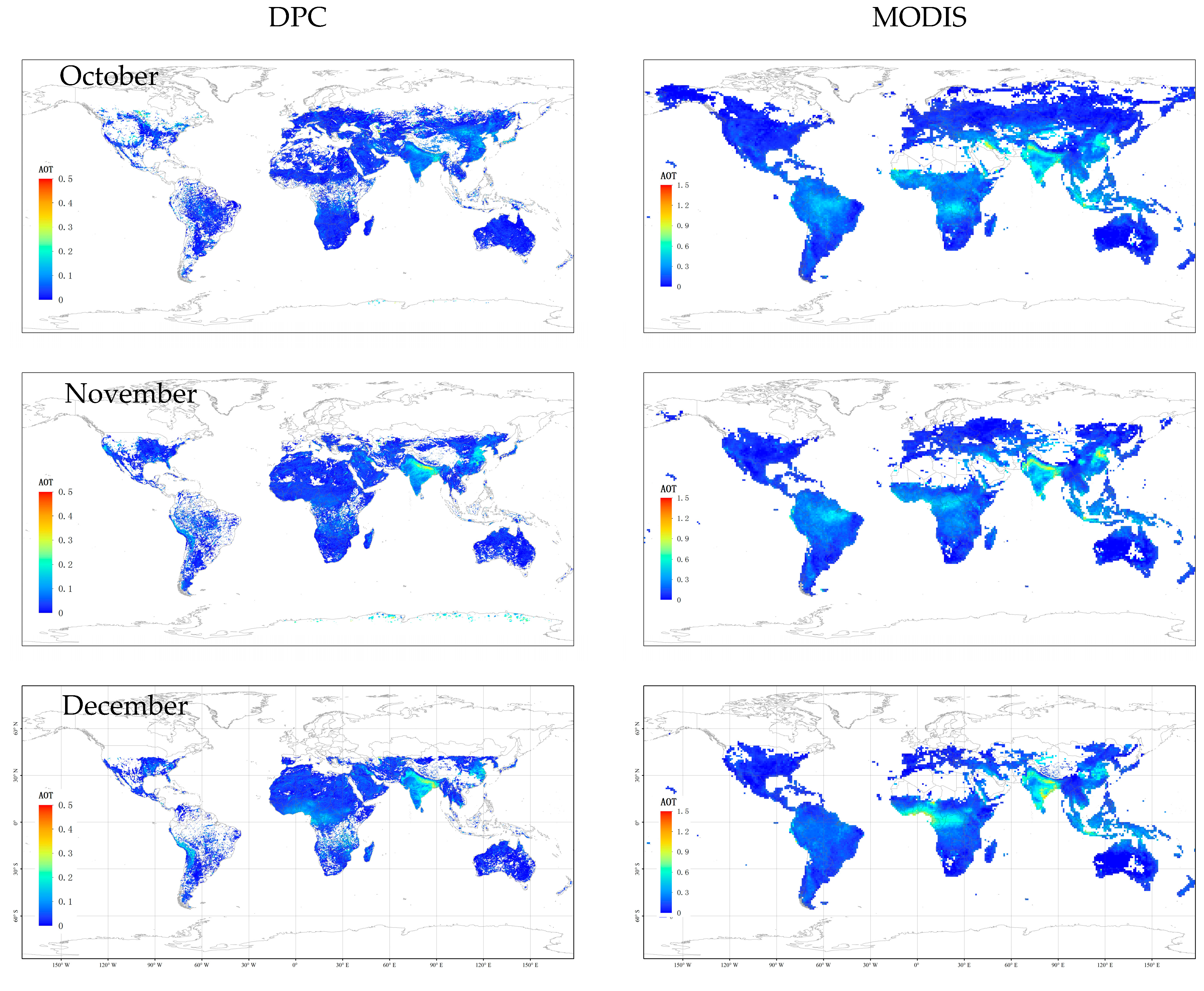
3. Comparison with MODIS Aerosol Product

The global distribution of monthly average AOD at 865 nm has been derived from DPC that illustrates the large spatial variability of the source regions and their monthly evolution. In order to provide us with an indication of internal consistency, the C6 AOD products at 660 nm of Aqua MODIS are collected for comparison [4]. Figure 1 shows the global distribution of monthly average AOD from October to December in 2018. It can be seen that the monthly average AOD of DPC and MODIS have similar spatial distributions. Significant high aerosol loading areas appear in northern China and Huanghuai areas in eastern China, the southern foothills of the Himalayas and India. DPC AOD retrievals demonstrate there was more haze in eastern China in November than in October and December. It agrees with the ground-based measurements of monthly mean PM 2.5 concentration over Beijing, which was reported to be 42, 71, 40 μg/m3 in October, November and December, respectively. In November and December, AOD over the southern foot of the Himalayas and India was higher than that in October. These phenomena are also found in MODIS AOD products. Though the monthly average AOD products of the two satellites have similar spatial distribution, the variation range of AOD values over the same regions differs significantly. In November, MODIS AOD can reach 0.9 in high-value areas such as northern China, while DPC AOD in the same area is only about 0.35. The reasons may be as follows: firstly, the AOD products of DPC are at 865 nm, while the AOD products of MODIS are at 660 nm. Although the AODs at two bands have significant correlation, the AOD at 660 nm is higher than that of 865 nm due to stronger scattering at shorter wavelength by aerosol particles. Secondly, the AOD of DPC is derived from polarization measurements. As polarized light is mainly sensitive to the scattering of fine particles, the AOD of DPC mainly reflects the contribution of fine particles, while the AOD of MODIS consists of scattering by both fine and coarse aerosol particles, which is another reason for the lower AOD inversion results of DPC.
Two satellite monthly average AOD products differ over some local areas. The significantly high AOD of MODIS over the south-central Sahara in December may come from dust storms. However, this phenomenon did not appear in DPC aerosol results as coarse desert dust particles almost do not polarize the incident sunlight [9]. In addition, the high aerosol loading of DPC over the Andes region of South America may come from volcanic aerosols dominated by fine particles, which is not evident in MODIS AOD products.

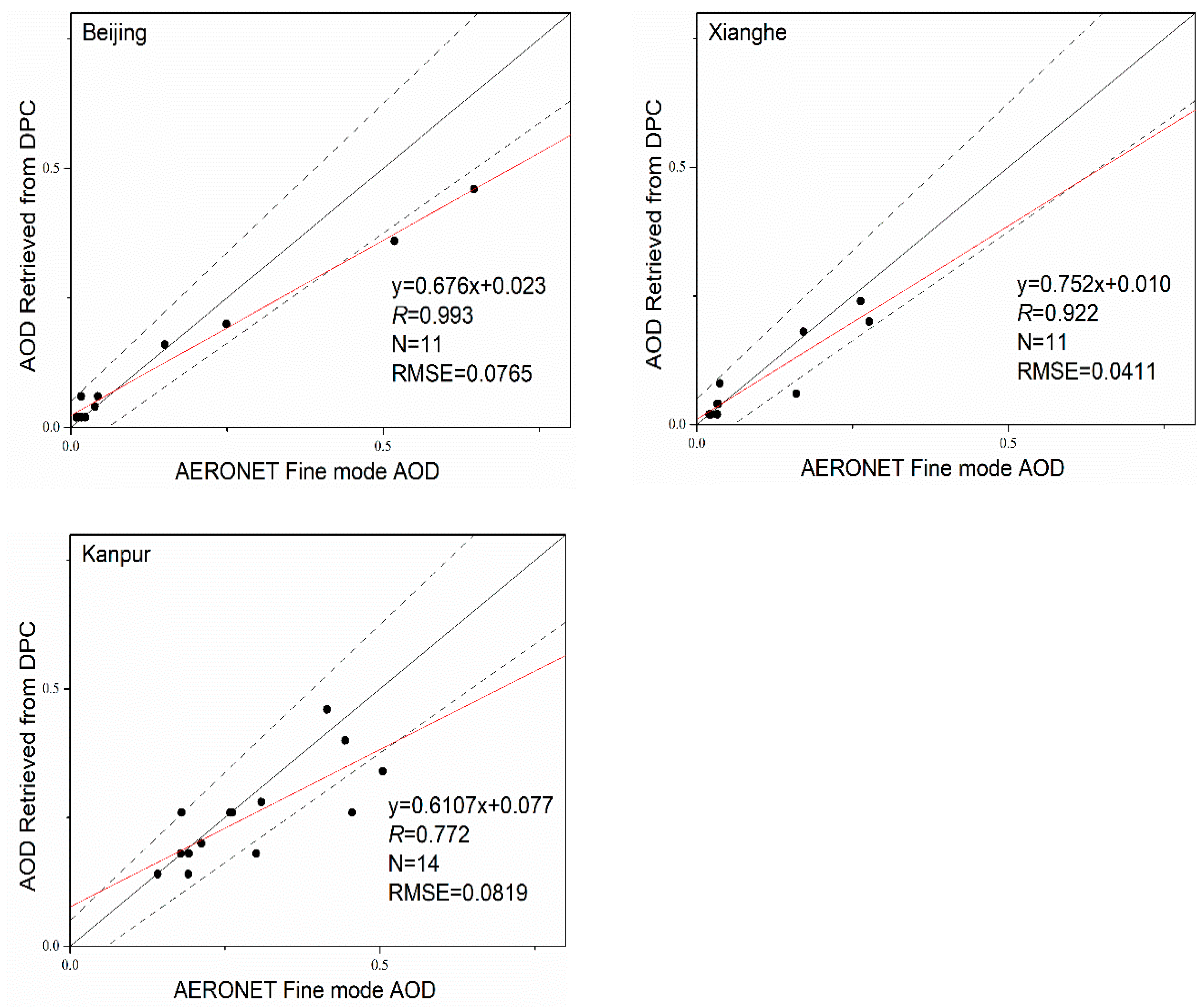
4. Validation against AERONET Measurements
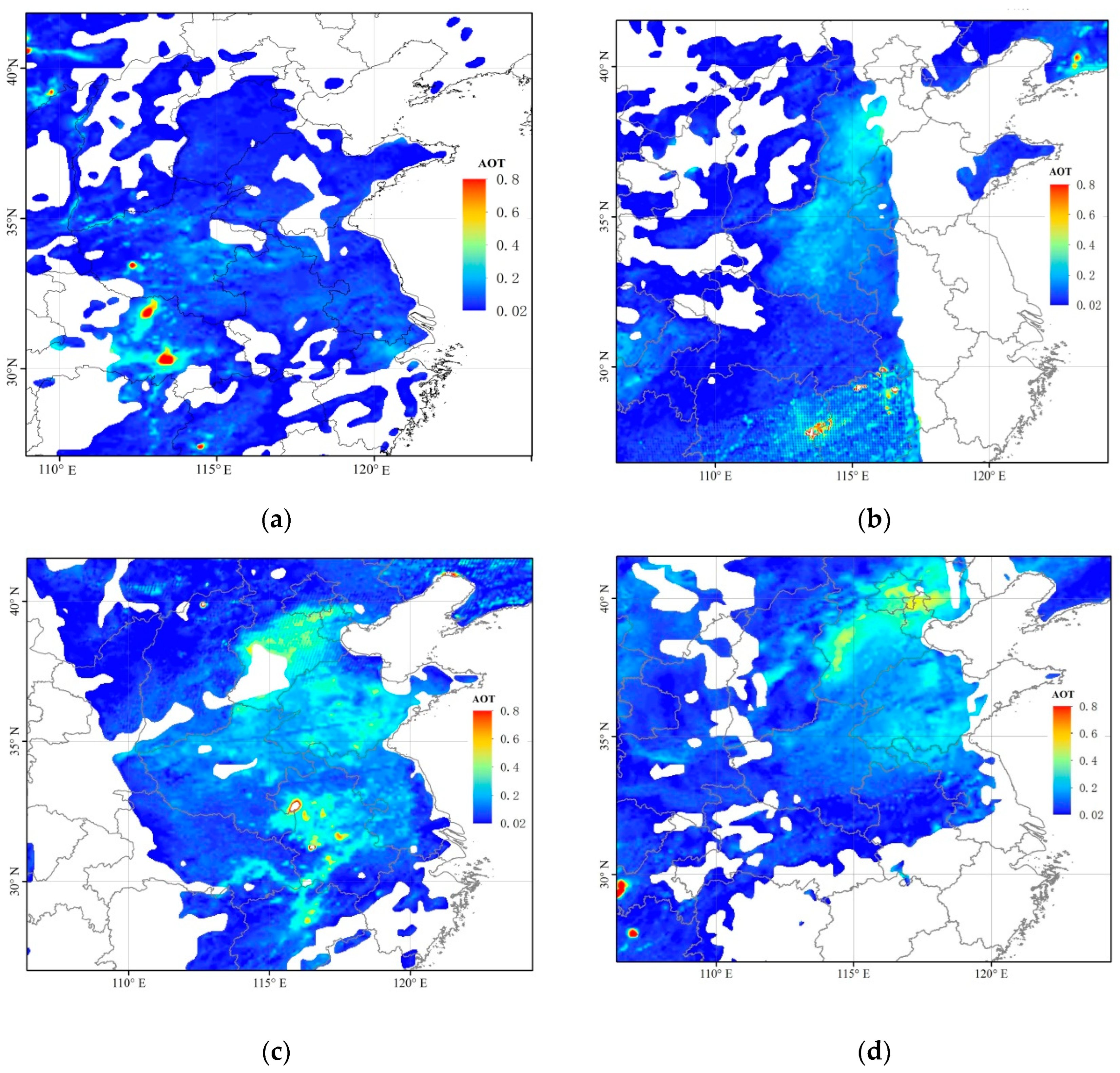
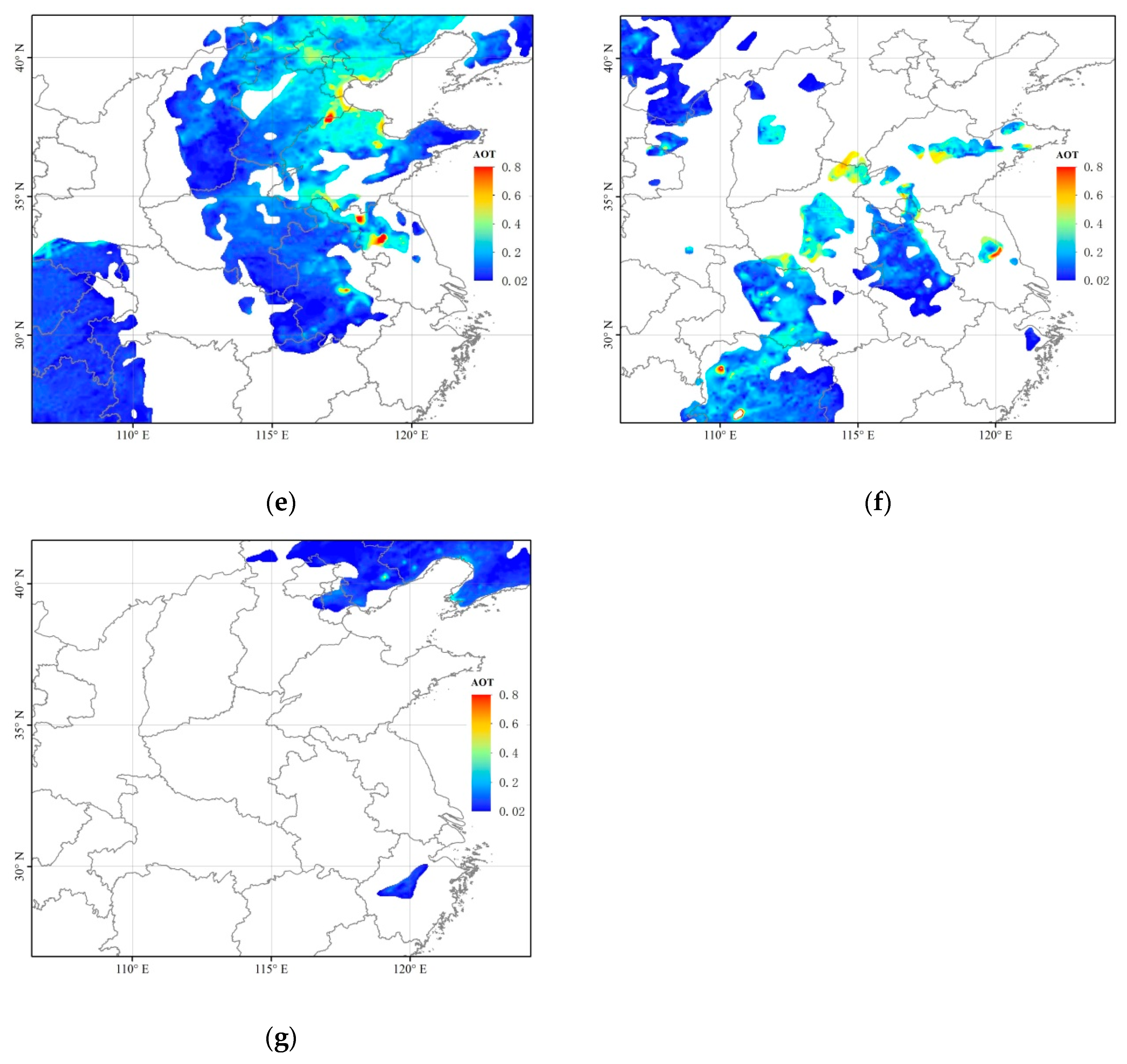
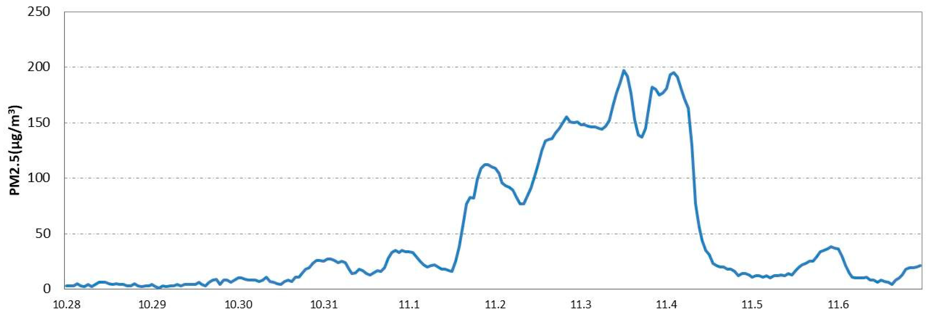
AERONET is a ground-based remote sensing aerosol network designed for aerosol research and validation of satellite aerosol retrievals [30]. Several identical sun photometers have been in operation on the ground measuring aerosol optical, microphysical and radiative properties. In order to further evaluate the performance of DPC AOD retrievals over land, AERONET fine-mode AOD at 865 nm data over Beijing (39.977° N, 116.381° E), Xianghe (39.754° N, 116.962° E) and Kanpur (26.513° N, 80.232° E) stations were collected from October to December in 2018 and compared with DPC AOD retrievals. To ensure more match-ups, the Level 1.5 data are used for comparison. For the comparison, retrievals within 10 km around each AERONET station are selected and averaged. The AERONET data are averaged within 0.5 h around the overpass time of the DPC. Figure 2 shows the scatter plots of comparing AERONET and DPC-derived AOD. Comparison with the AERONET fine AOD inversions indicates reasonable agreement. The correlation coefficients are greater than 0.9 and the RMSE are lower than 0.08 for Beijing and Xianghe stations. The match is slightly poorer for Kanpur, as a relatively lower correlation of 0.772 and slightly larger RMSE of 0.082 are found from the two datasets at Kanpur.
A previous study comparing PARASOL and AERONET fine-mode AOD data over Beijing and Kanpur demonstrated a larger retrieval bias over Beijing [31]. The RMSE was found to be 0.198 and 0.138 for Beijing and Kanpur, respectively, in winter, and the fitting slope of PARASOL was 0.323 and 0.629 for Beijing and Kanpur, respectively. From the validation results, DPC retrievals show similar performance with PARASOL in urban areas. Similar conclusion was also reported using the optimized retrieval algorithm [22].

5. Case Study

Over land surfaces, polarization is mainly sensitive to the presence of small particles resulting from anthropogenic activities and is sensitive to pollution events and smoke. The location, the strengths, and the variability of the aerosol sources can be then monitored at a global or regional scale. Affected by high humidity and stable meteorological field from 31 October to 3 November 2018, severe haze weather occurred in north-eastern China, covering Beijing, Tianjin and southern Hebei. The PM2.5 concentration over Beijing reached about 200 μg/m3 during this time period. Figure 3 shows the fine-mode AOD at 865 nm retrieved from DPC polarized radiance. Figure 3a reported clear weather on 30 October with the fine-mode AOD lower than 0.1 over north-eastern China. On 31 October, an obvious increase in AODf was observed over the provinces of Henan and southern Hebei, as shown in Figure 3b. AODf reached ~0.3 over southern Hebei.
On 1 November, the range of high-value areas expanded, covering southern Beijing, southern Hebei, Tianjin, Shandong and Henan. The highest value was observed in southern Hebei and northwest of Tianjin. AODf reached 0.4. It can be seen from Figure 3d that on 2 November, the AODf over southern Hebei, Beijing and Tianjin continued to accumulate, reaching about 0.5. On 3 November, the AODf over southern Hebei began to decline. Beijing and Tianjin were still located in the center of the high-value area, and the haze further spread to the south of the northeast region. Due to cloud coverage on 4 and 5 November, there were no AODf retrievals over most of the monitoring areas. However, Figure 3g shows that AODf in southeast Liaoning (top right corner of the figure) was less than 0.1 on 5 November. Several studies reported that the relationship between fine-mode AOD and PM 2.5 was significantly closer than that between total AOD and PM 2.5 under hazy weather conditions [32,33]. A high correlation of r = 0.74 was found between find mode AOD and PM 2.5 over China [33]. Figure 4 shows the ground-based PM 2.5 observation data at Beijing, it can be concluded that the haze pollution covering the area dissipated. The significant high values (over 0.8) on 1 November and 3 November may be caused by poor cloud identification or local pollution emission sources, which require further investigation.

6. Conclusions

DPC onboard the GF-5 satellite in orbit between May 2018 and April 2020 is the first Chinese MAP designed for aerosol and cloud detection. Compared with PARASOL which ended its mission in 2013, DPC has a similar band design (without the band of 1020 nm), with the maximum observation angle of 12, and the relatively higher spatial resolution of 3.3 km.
The aerosol optical depth over land with DPC multi-angle polarization observations from October to December in 2018 was retrieved. Compared with the monthly average AOD of MODIS, it is found that the spatial distribution of two satellite aerosol products is in good agreement, which can reveal both the high aerosol loading in eastern China, and the southwest side of the Himalayas and India. However, since the scattering of sunlight by fine aerosol particles generates highly polarized light while coarse-mode aerosol particles almost do not polarize incident solar light, only the fine-mode aerosol properties can be retrieved. The AOD derived from DPC is obviously lower than MODIS AOD, especially for those high aerosol loading areas.
Spatial distribution differences of two AOD products are also found in some areas. The significant high-value area of MODIS in the south-central Sahara in December which are due to dust storms did not appear in DPC aerosol results. In addition, the high DPC values in the Andes region of South America may come from volcanic aerosols dominated by fine particles, which is not evident in MODIS AOD products.
AERONET aerosol measurements and fine-mode retrievals over Beijing, Xianghe and Kanpur were used to evaluate the accuracy of DPC aerosol retrievals. The correlation coefficients are greater than 0.9 and the RMSE are lower than 0.08 for Beijing and Xianghe stations. For Kanpur, a relatively lower correlation of 0.772 and larger RMSE of 0.082 are found. It was found that the AOD retrievals of DPC agree better with fine AOD than total AOD. In the future, with further improvement of DPC calibration accuracy, marine aerosol products and other aerosol products which reflect the full-size particles’ contribution retrieved with both polarized and unpolarized measurements will be developed.

Author Contributions

Conceptualization, S.W.; methodology, S.W. and L.F.; software, L.F.; validation, L.F. and W.G.; formal analysis, S.W. and P.Z.; investigation, W.G., X.H. and X.S.; data curation, S.W.; writing—original draft preparation, S.W.; writing—review and editing, W.G. and L.F.; visualization, L.F. and S.W.; supervision, P.Z., N.L., X.Z. and S.T.; project administration, W.W., X.Z. and X.H.; funding acquisition, X.Z. and X.H. All authors have read and agreed to the published version of the manuscript.

Funding

This research was funded by the National Natural Science Foundation of China (Grant No: 41975032) and the National Key Research and Development Program of China (no. 2017YFC0209704).

Data Availability Statement

The AERONET data used in this study are available via https://aeronet.gsfc.nasa.gov/ (accessed on 28 February 2019). The DPC data from the GF-5 satellite are provided by China Center for Resources Satellite Data and Application (http://www.cresda.com/EN/) (accessed on 8 January 2019). The used MODIS data are available from the Level-1 and Atmosphere Archive & Distribution System (LAADS) (https://ladsweb.modaps.eosdis.nasa.gov/search/) (lastly accessed on 25 August 2022).

Acknowledgments

We are thankful to Jin Hong for providing the calibration coefficients of DPC and helpful discussions. We thank CRESDA team for providing the Level 1B datasets of DPC. We are also thankful to AERONET team for maintaining the data. The ground-based PM2.5 data were provided by the aqistudy team from their website at https://www.aqistudy.cn/ (last access: 22 July 2022).

Conflicts of Interest

The authors declare no conflict of interest.

References

  1. Nakata, M.; Sano, I.; Mukai, S. Investigation of air pollution and regional climate change due to anthropogenic aerosols. In Remote Sensing Technologies and Applications in Urban Environments; International Society for Optics and Photonics: Bellingham, WA, USA, 2016; Volume 10008, p. 100080Z. [Google Scholar]
  2. Mishchenko, M.I.; Cairns, B.; Kopp, G.; Schueler, C.F.; Fafaul, B.A.; Hansen, J.E.; Hooker, R.J.; Itchkawich, T.; Maring, H.B.; Travis, L.D. Accurate monitoring of terrestrial aerosols and total solar irradiance: Introducing the Glory Mission. Bull. Am. Meteorol. Soc. 2007, 88, 677–692. [Google Scholar] [CrossRef] [Green Version]
  3. Kaufman, Y.J.; Tanré, D.; Remer, L.A.; Vermote, E.F.; Chu, A.; Holben, B.N. Operational remote sensing of tropospheric aerosol over land from EOS moderate resolution imaging spectroradiometer. J. Geophys. Res. Atmos. 1997, 102, 17051–17067. [Google Scholar] [CrossRef]
  4. Levy, R.C.; Remer, L.A.; Mattoo, S.; Vermote, E.F.; Kaufman, Y.J. Second-generation operational algorithm: Retrieval of aerosol properties over land from inversion of Moderate Resolution Imaging Spectroradiometer spectral reflectance. J. Geophys. Res. Atmos. 2007, 112, D13211. [Google Scholar] [CrossRef] [Green Version]
  5. Diner, D.; Beckert, J.; Reilly, T.; Bruegge, C.; Conel, J.; Kahn, R.; Martonchik, J.; Ackerman, T.; Davies, R.; Gerstl, S.; et al. Multi-angle Imaging SpectroRadiometer (MISR) instrument description and experiment overview. IEEE Trans. Geosci. Remote Sens. 1998, 36, 1072–1087. [Google Scholar] [CrossRef]
  6. Diner, D.J.; Martonchik, J.V.; Kahn, R.A.; Pinty, B.; Gobron, N.; Nelson, D.L.; Holben, B.N. Using angular and spectral shape similarity constraints to improve MISR aerosol and surface retrievals over land. Remote Sens. Environ. 2005, 94, 155–171. [Google Scholar] [CrossRef]
  7. Kokhanovsky, A.A. The modern aerosol retrieval algorithms based on the simultaneous measurements of the intensity and polarization of reflected solar light: A review. Front. Environ. Sci. 2015, 3, 4. [Google Scholar] [CrossRef] [Green Version]
  8. Fougnie, B.; Bracco, G.; Lafrance, B.; Ruffel, C.; Hagolle, O.; Tinel, C. PARASOL in-flight calibration and performance. Appl. Opt. 2007, 46, 5435–5451. [Google Scholar] [CrossRef] [PubMed] [Green Version]
  9. Tanré, D.; Bréon, F.M.; Deuzé, J.L.; Dubovik, O.; Ducos, F.; Francois, P.; Goloub, P.; Herman, M.; Lifermann, A.; Waquet, F. Remote sensing of aerosols by using polarized, directional and spectral measurements within the A-Train: The PARASOL mission. Atmos. Meas. Tech. 2011, 4, 1383–1395. [Google Scholar] [CrossRef] [Green Version]
  10. Marbach, T.; Riedi, J.; Lacan, A.; Schlüssel, P. The 3MI mission: Multi-viewing-channel-polarisation imager of the EUMETSAT polar system: Second generation (EPS-SG) dedicated to aerosol and cloud monitoring. In Polarization Science and Remote Sensing VII; International Society for Optics and Photonics: Bellingham, WA, USA, 2015; Volume 9613, p. 961310. [Google Scholar]
  11. Hasekamp, O.P.; Fu, G.; Rusli, S.P.; Wu, L.; Di Noia, A.; aan de Brugh, J.; Landgraf, J.; Martijn Smit, J.; Rietjens, J.; van Amerongen, A. Aerosol measurements by SPEXone on the NASA PACE mission: Expected retrieval capabilities. J. Quant. Spectrosc. Radiat. Transf. 2019, 227, 170–184. [Google Scholar] [CrossRef]
  12. Werdell, P.J.; Behrenfeld, M.J.; Bontempi, P.S.; Boss, E.; Cairns, B.; Davis, G.T.; Franz, B.A.; Gliese, U.B.; Gorman, E.T.; Hasekamp, O.; et al. The Plankton, Aerosol, Cloud, ocean Ecosystem (PACE) mission: Status, science, advances. Bull. Am. Meteorol. Soc. 2019, 100, 1775–1794. [Google Scholar] [CrossRef]
  13. Snik, F.; Karalidi, T.; Keller, C.U. Spectral modulation for full linear polarimetry. Appl. Opt. 2009, 48, 1337–1346. [Google Scholar] [CrossRef] [PubMed]
  14. Li, Z.; Hou, W.; Hong, J.; Zheng, F.; Luo, D.; Wang, J.; Gu, X.; Qiao, Y. Directional Polarimetric Camera (DPC): Monitoring aerosol spectral optical properties over land from satellite observation. J. Quant. Spectrosc. Radiat. Transf. 2018, 218, 21–37. [Google Scholar] [CrossRef]
  15. Huang, C.; Chang, Y.Y.; Xiang, G.F.; Han, L.; Chen, F.; Luo, D.G.; Li, S.; Sun, L.; Tu, B.H.; Meng, B.H.; et al. Polarization measurement accuracy analysis and improvement methods for the directional polarimetric camera. Opt. Express 2020, 28, 38638–38666. [Google Scholar] [CrossRef] [PubMed]
  16. Deuzé, J.L.; Bréon, F.M.; Devaux, C.; Goloub, P.; Herman, M.; Lafrance, B.; Maignan, F.; Marchand, A.; Nadal, F.; Perry, G.; et al. Remote sensing of aerosols over land surfaces from POLDER-ADEOS-1 polarized measurements. J. Geophys. Res. Earth Surf. 2001, 106, 4913–4926. [Google Scholar] [CrossRef] [Green Version]
  17. Wang, S.; Fang, L.; Zhang, X.; Wang, W. Retrieval of aerosol properties for fine/coarse mode aerosol mixtures over Beijing from PARASOL measurements. Remote Sens. 2015, 7, 9311–9324. [Google Scholar] [CrossRef] [Green Version]
  18. Dubovik, O.; Herman, M.; Holdak, A.; Lapyonok, T.; Tanre, D.; Deuze, J.L.; Ducos, F.; Sinyuk, A.; Lopatin, A. Statistically optimized inversion algorithm for enhanced retrieval of aerosol properties from spectral multi-angle polarimetric satellite observations. Atmos. Meas. Tech. 2011, 4, 975–1018. [Google Scholar] [CrossRef] [Green Version]
  19. Hasekamp, O.P.; Litvinov, P.; Butz, A. Aerosol properties over the ocean from PARASOL multiangle photopolarimetric measurements. J. Geophys. Res. Atmos. 2011, 116, D14204. [Google Scholar] [CrossRef] [Green Version]
  20. Fu, G.; Hasekamp, O. Retrieval of aerosol microphysical and optical properties over land using a multimode approach. Atmos. Meas. Tech. 2018, 11, 6627–6650. [Google Scholar] [CrossRef] [Green Version]
  21. Xu, F.; van Harten, G.; Diner, D.J.; Kalashnikova, O.V.; Seidel, F.C.; Bruegge, C.J.; Dubovik, O. Coupled retrieval of aerosol properties and land surface reflection using the Airborne Multiangle SpectroPolarimetric Imager. J. Geophys. Res. Atmos. 2017, 122, 7004–7026. [Google Scholar] [CrossRef]
  22. Fang, L.; Hasekamp, O.; Fu, G.; Gong, W.; Wang, S.; Wang, W.; Han, Q.; Tang, S. Retrieval of Aerosol Optical Properties over Land Using an Optimized Retrieval Algorithm Based on the Directional Polarimetric Camera. Remote Sens. 2022, 14, 4571. [Google Scholar] [CrossRef]
  23. Kang, Q.; Yuan, Y.L.; Li, J.J.; Zhai, W.C.; Wu, H.Y.; Hong, J.; Zheng, X.B. Effect of divergence angle of polarization calibration source on DPC polarization calibration: Analysis and validation. J. Remote Sens. 2018, 22, 203–210. (In Chinese) [Google Scholar]
  24. Hagolle, O.; Goloub, P.; Deschamps, P.Y.; Cosnefroy, H.; Briottet, X.; Bailleul, T.; Nicolas, J.M.; Parol, F.; Lafrance, B.; Herman, M. Results of POLDER in-flight calibration. IEEE Trans. Geosci. Remote Sens. 1999, 37, 1550–1566. [Google Scholar] [CrossRef] [Green Version]
  25. Nadal, F.; Bréon, F.M. Parameterization of surface polarized reflectance derived from POLDER spaceborne measurements. IEEE Trans. Geosci. Remote Sens. 1999, 37, 1709–1718. [Google Scholar] [CrossRef]
  26. Deuzé, J.L.; Herman, M.; Goloub, P.; Tanré, D.; Marchand, A. Characterization of aerosols over ocean from POLDER/ADEOS-1. Geophys. Res. Lett. 1999, 26, 1421–1424. [Google Scholar] [CrossRef]
  27. Dubovik, O.; Holben, B.N.; Eck, T.F.; Smirnov, A.; Kaufman, Y.J.; King, M.D.; Tanre, D.; Slutsker, I. Climatology of aerosol absorption and optical properties in key worldwide locations. J. Atmos. Sci. 2002, 59, 590–608. [Google Scholar] [CrossRef]
  28. Bréon, F.M.; Colzy, S. Cloud detection from the spaceborne POLDER instrument and validation against surface synoptic observations. J. Appl. Meteorol. 1999, 38, 777–785. [Google Scholar] [CrossRef]
  29. Shettle, E.P.; Fenn, R.W. Models for the Aerosols of the Lower Atmosphere and the Effects of Humidity Variations on Their Optical Properties; No. AFGL-TR-79-0214; Air Force Geophysics Lab: Hanscomb AFB, MA, USA, 1979; p. 94. [Google Scholar]
  30. Holben, B.N.; Eck, T.F.; Slutsker, I.A.; Tanre, D.; Buis, J.P.; Setzer, A.; Vermote, E.; Reagan, J.A.; Kaufman, Y.J.; Nakajima, T.; et al. AERONET—A federated instrument network and data archive for aerosol characterization. Remote Sens. Environ. 1998, 66, 1–16. [Google Scholar] [CrossRef]
  31. Gu, X.F.; Wang, S.P.; Fang, L.; Yu, T.; Gao, J. Sensitivity study on polarized aerosol retrievals of PARASOL in Beijing and Kanpur. Atmos. Meas. Tech. Discuss. 2011, 4, 5773–5806. [Google Scholar] [CrossRef]
  32. Zhang, Y.; Li, D. Estimation of PM2.5 from fine-mode aerosol optical depth. J. Remote Sens. 2013, 17, 929–943. [Google Scholar]
  33. Yan, X.; Shi, W.; Li, Z.; Li, Z.; Luo, N.; Zhao, W.; Wang, H.; Yu, X. Satellite-based PM2.5 estimation using fine-mode aerosol optical thickness over China. Atmos. Environ. 2017, 170, 290–302. [Google Scholar] [CrossRef]
Figure 1. The global monthly average AOD from October to December in 2018 derived from DPC and MODIS.
Atmosphere 13 01884 g001
Figure 2. Correlation of the AOD derived from DPC and AERONET AOD measurements and fine-mode AOD retrievals over Beijing, Xianghe and Kanpur. The dash lines correspond to ±0.05 ± 0.15τAERONET error where τAERONET is the simultaneous AERONET AOD measurements. The black and red solid line represent the one-to-one line and the fitting line, respectively.
Atmosphere 13 01884 g002
Figure 3. The fine-mode AOD retrieved from DPC over north China from (a) 30 October to (f) 5 November 2018. (a) 30 October 2018, (b) 31 October 2018, (c) 1 November 2018, (d) 2 November 2018, (e) 3 November 2018, (f) 4 November 2018, (g) 5 November 2018.
Atmosphere 13 01884 g003aAtmosphere 13 01884 g003b
Figure 4. The ground-based PM2.5 concentration measurement over Beijing from 28 October to 6 November.
Atmosphere 13 01884 g004
Table 1. The performance specifications of the DPC and POLDER.
ItemsDPCPOLDER
swath(km)18501600
FOV±50° (Along track/Across track)±51° (Along track)
±43° (Across track)
spatial resolution3.3 km (nadir)6 km × 7 km (nadir)
pixel number on the CCD512 × 512274×242
bands (nm, P stands for polarization)443, 490 (P), 565, 670 (P),
763, 765, 865 (P), 910
443, 490 (P), 565, 670 (P),
763, 765, 865 (P), 910
band width(nm)20, 20, 20, 20, 10,
40, 40, 20
20, 20, 20, 20, 10,
40, 40, 20
polarization direction0°, 60°, 120°0°, 60°, 120°
radiation calibration error≤5%2% for shorter wavelength (≤565 nm) 3% for longer wavelength ( 565 nm)
polarization calibration errorin DoLP≤0.021%
Publisher’s Note: MDPI stays neutral with regard to jurisdictional claims in published maps and institutional affiliations.

