A Study of False Alarms of a Major Sudden Stratospheric Warming by Real-Time Subseasonal-to-Seasonal Forecasts for the 2017/2018 Northern Winter


Abstract
:1. Introduction
2. Data
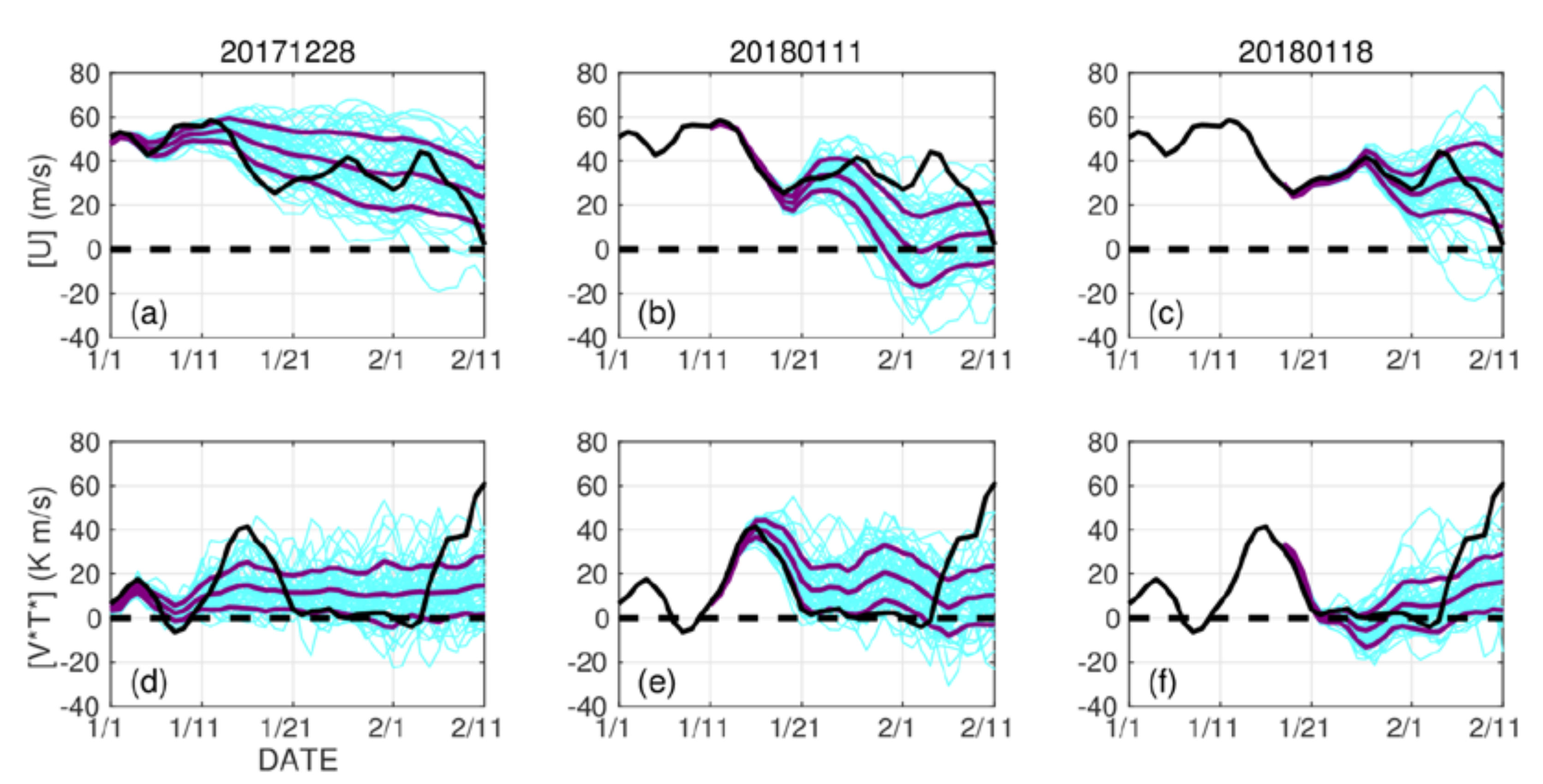
3. Results
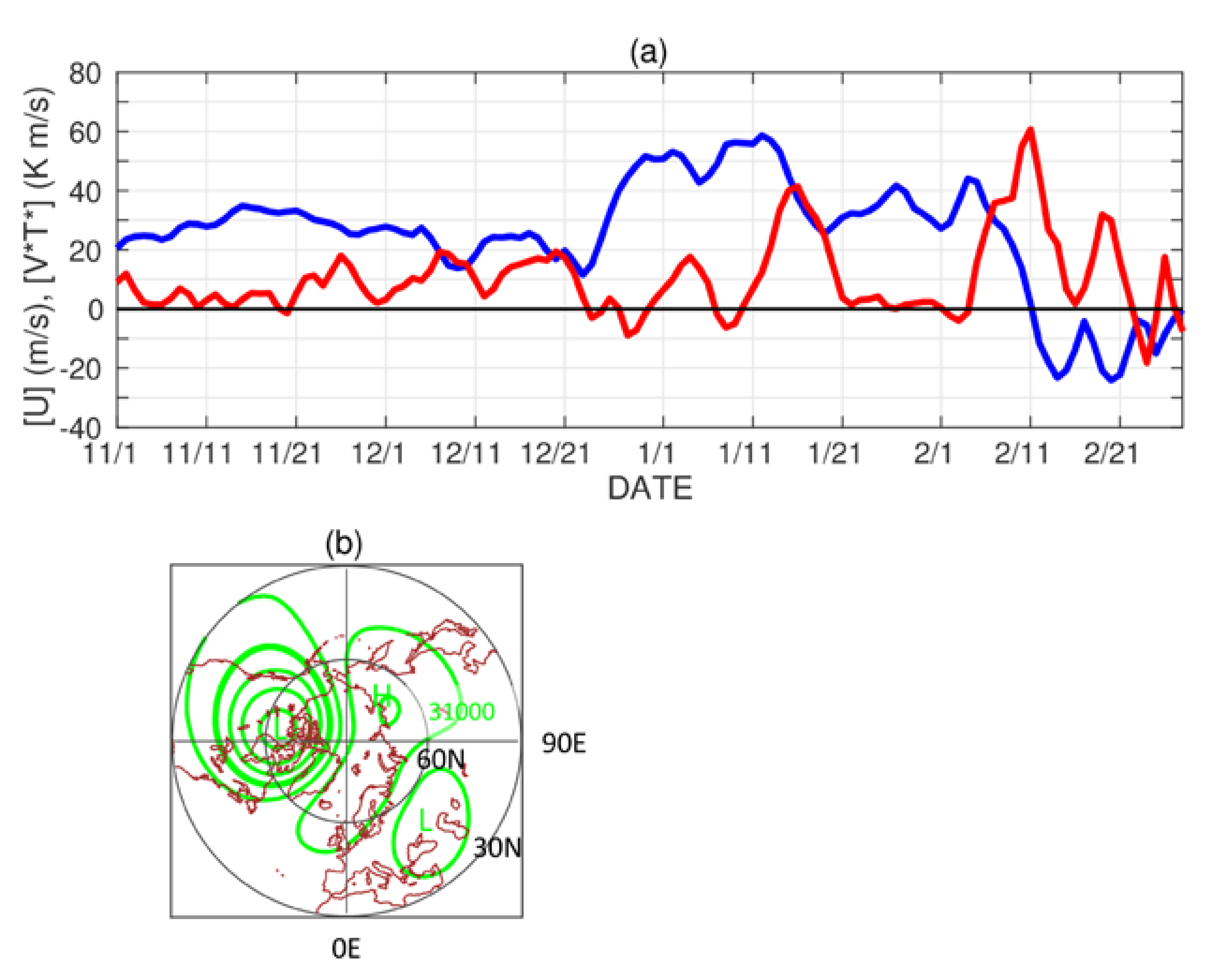
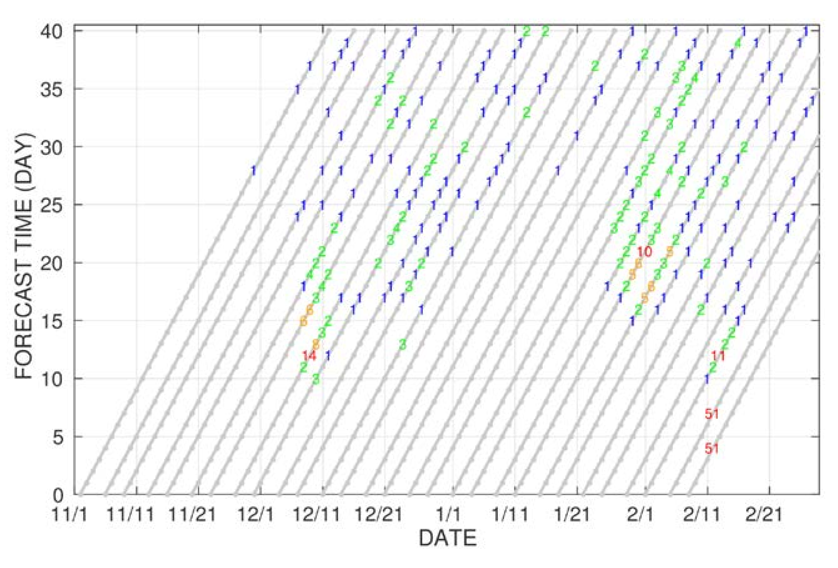
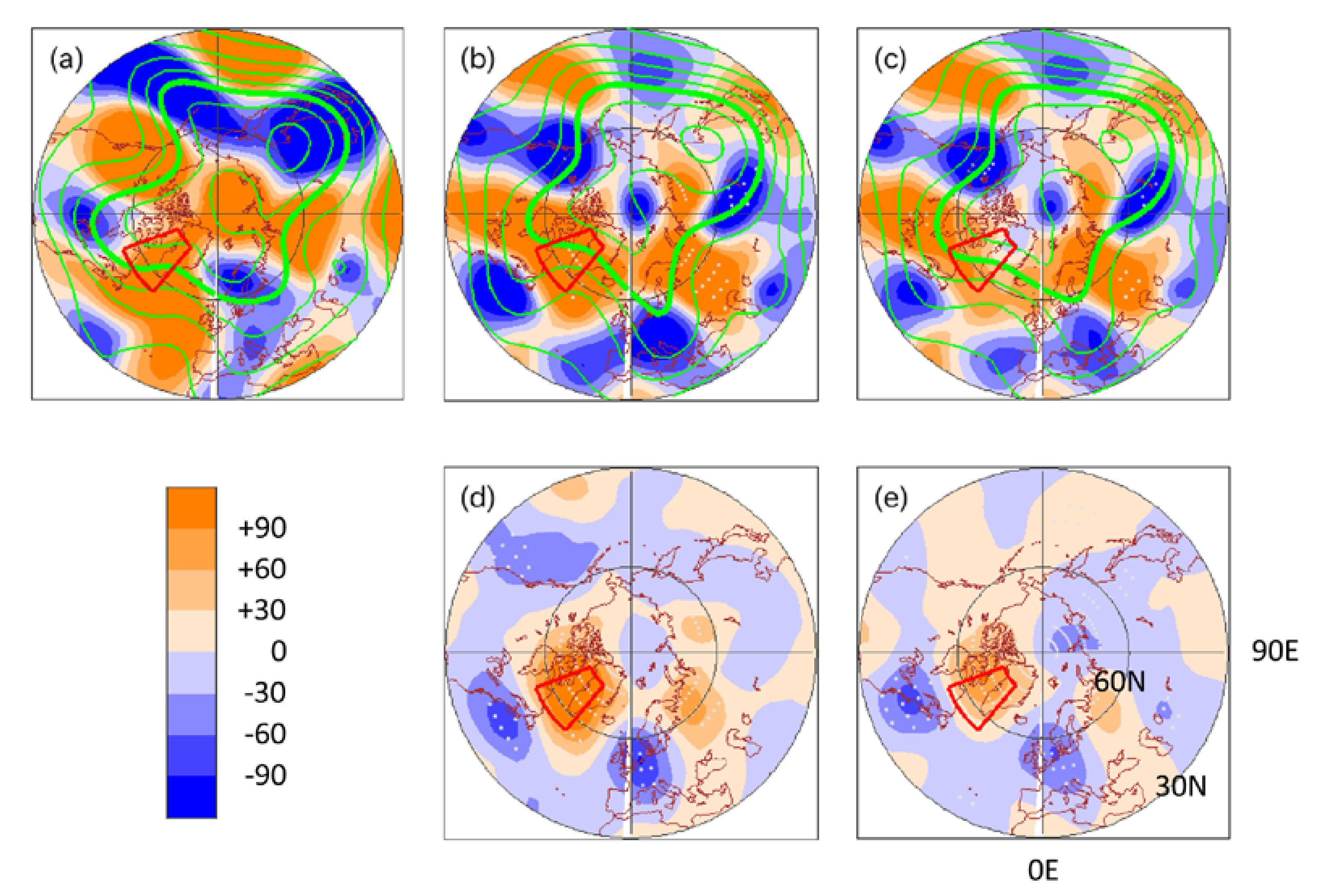
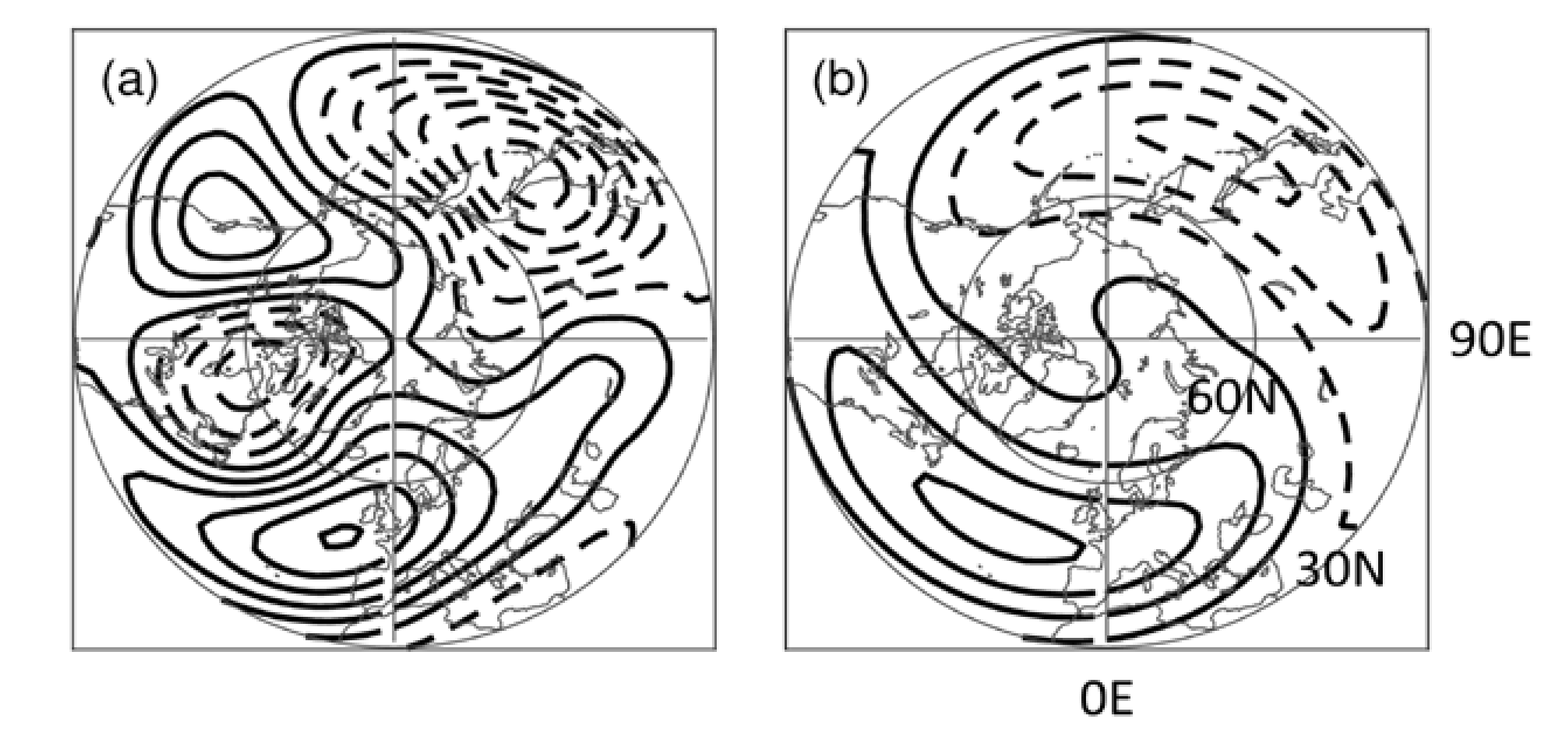
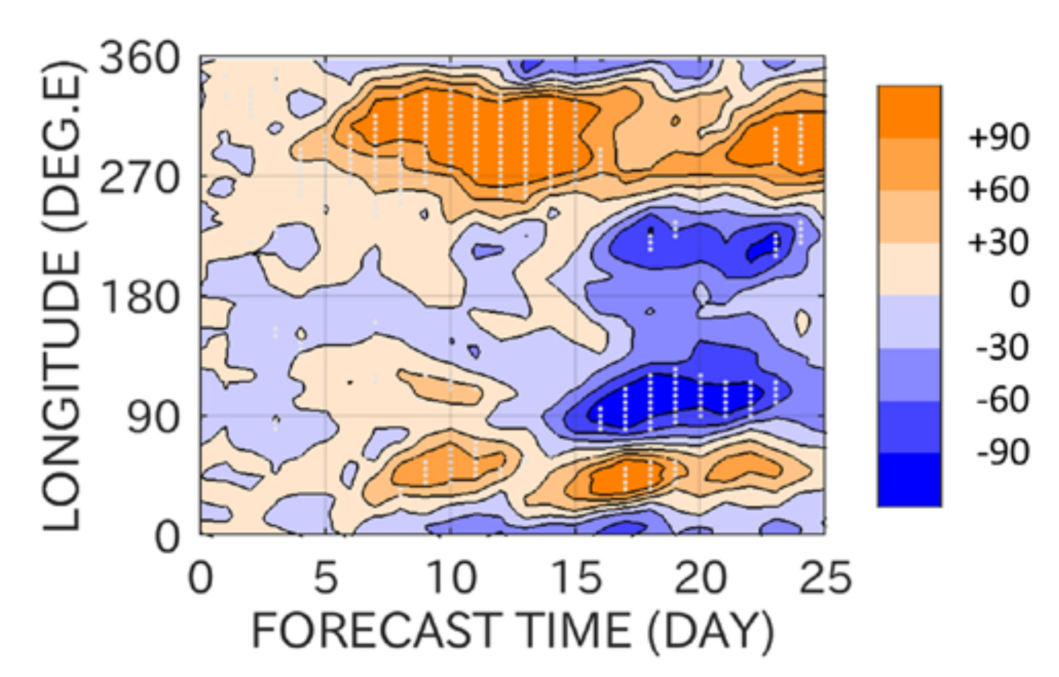
3.1. Overview
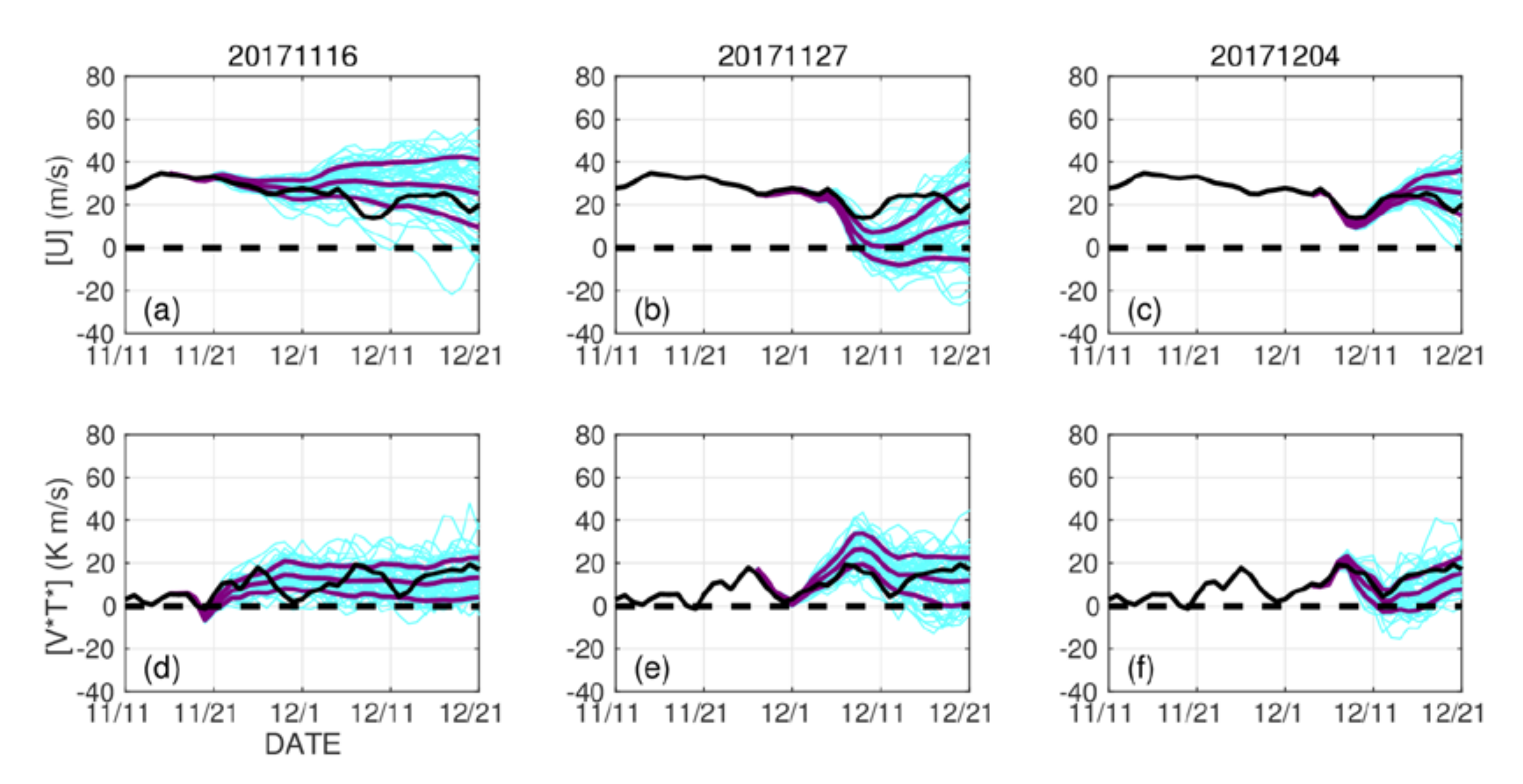
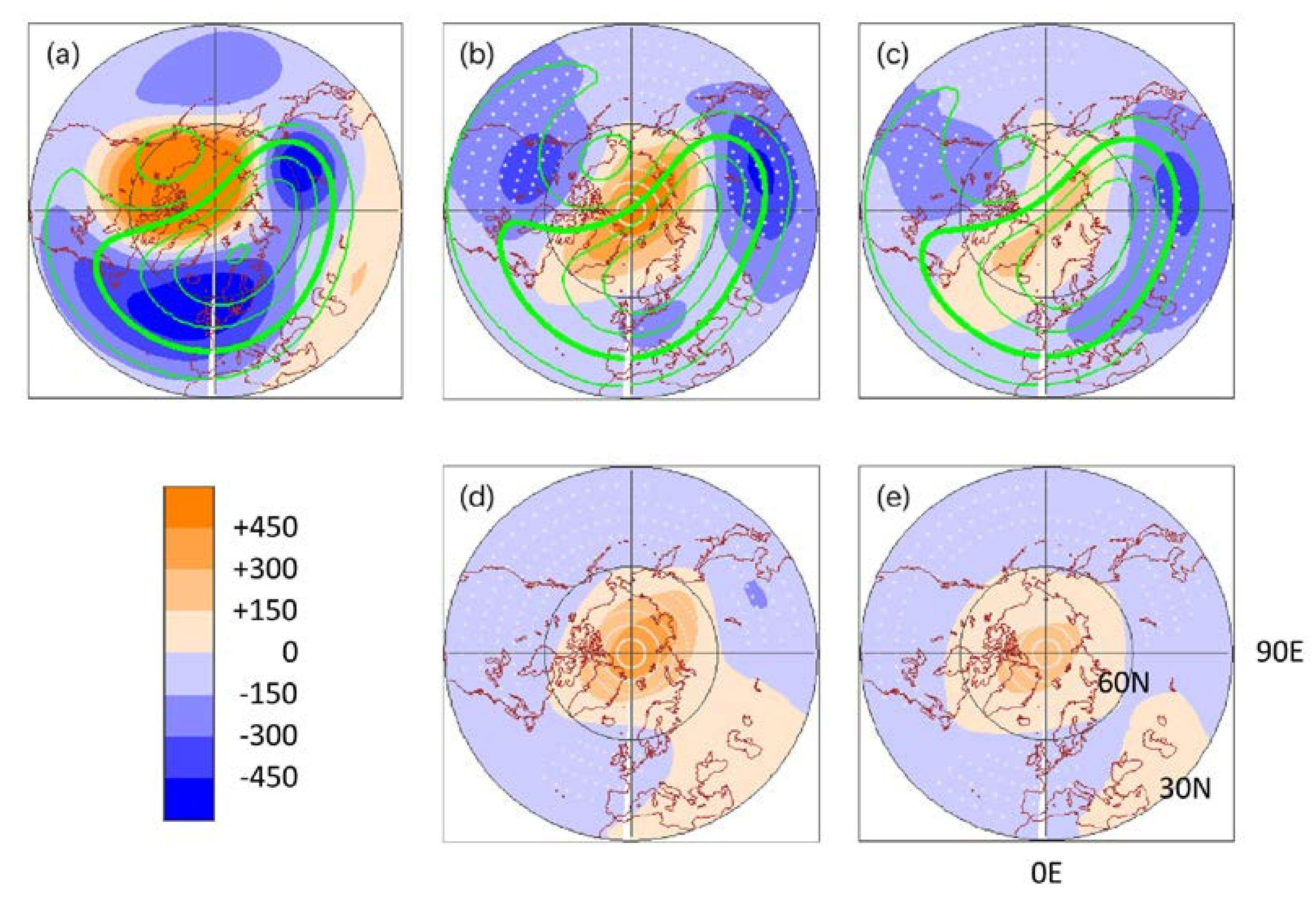
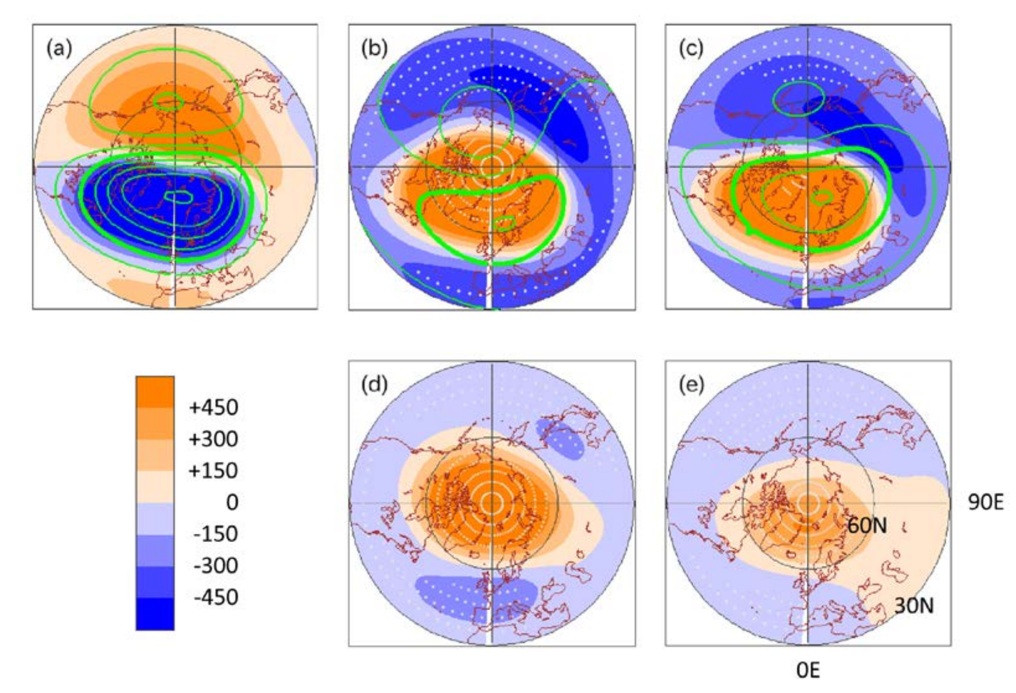
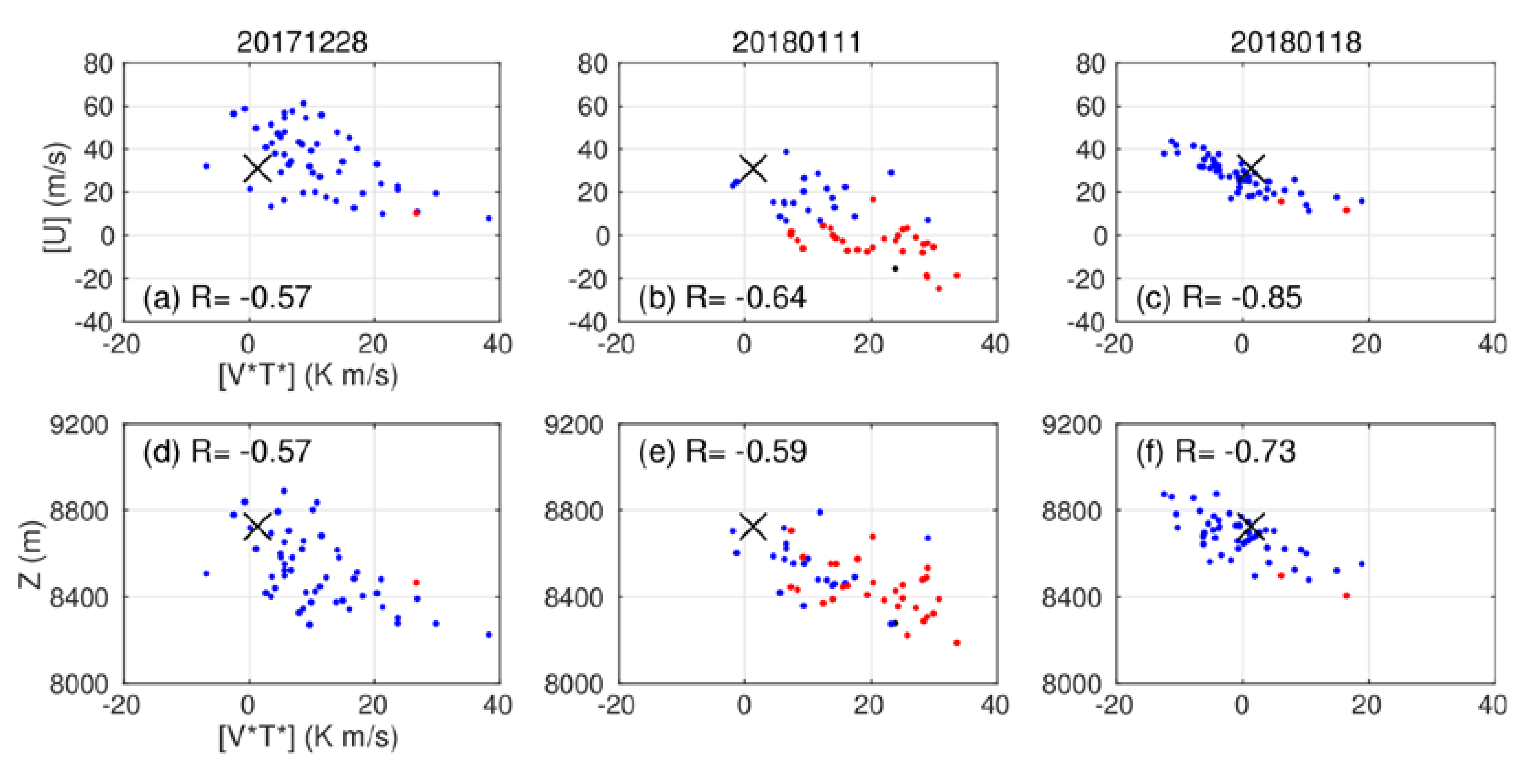
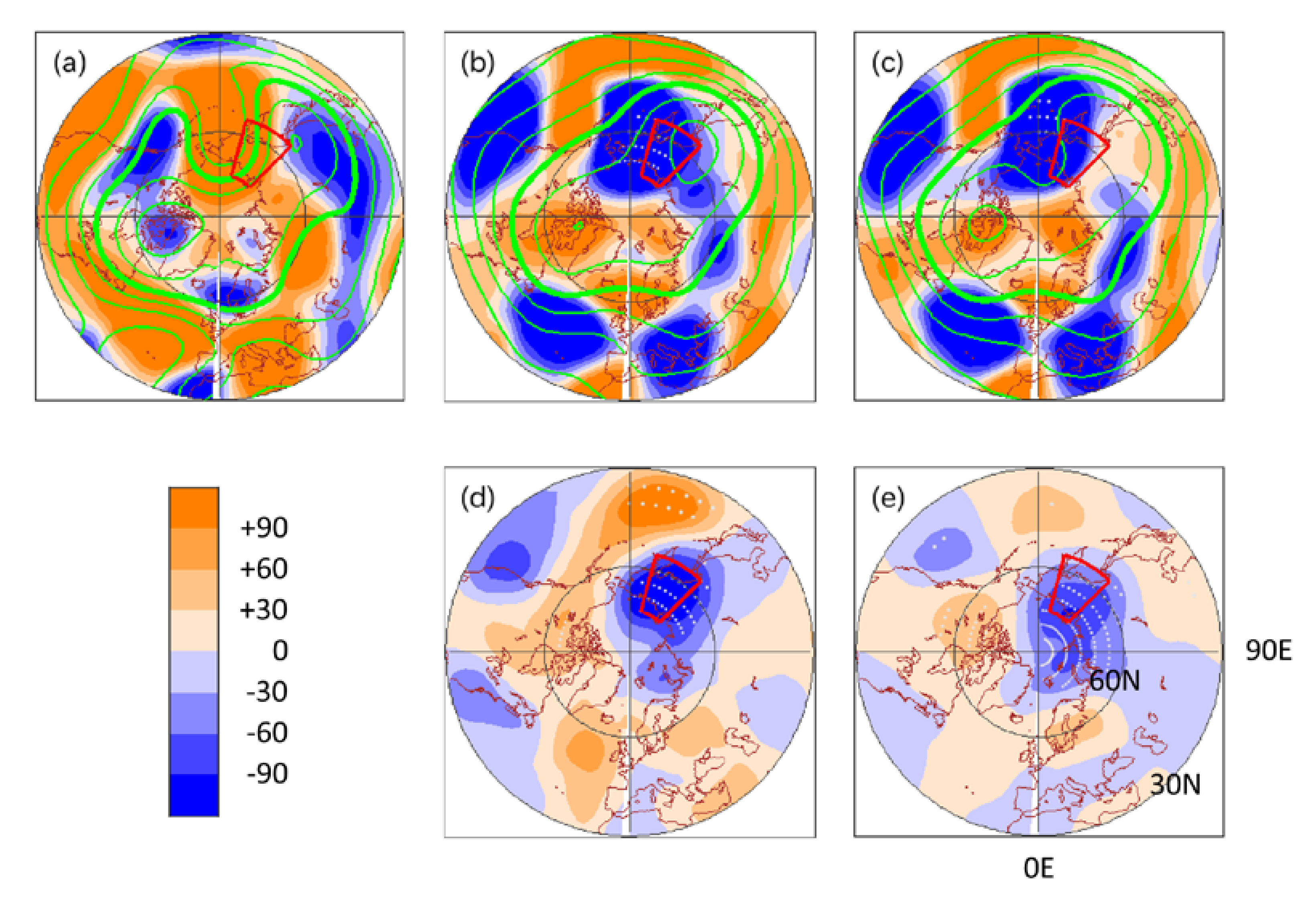
3.2. First Cluster
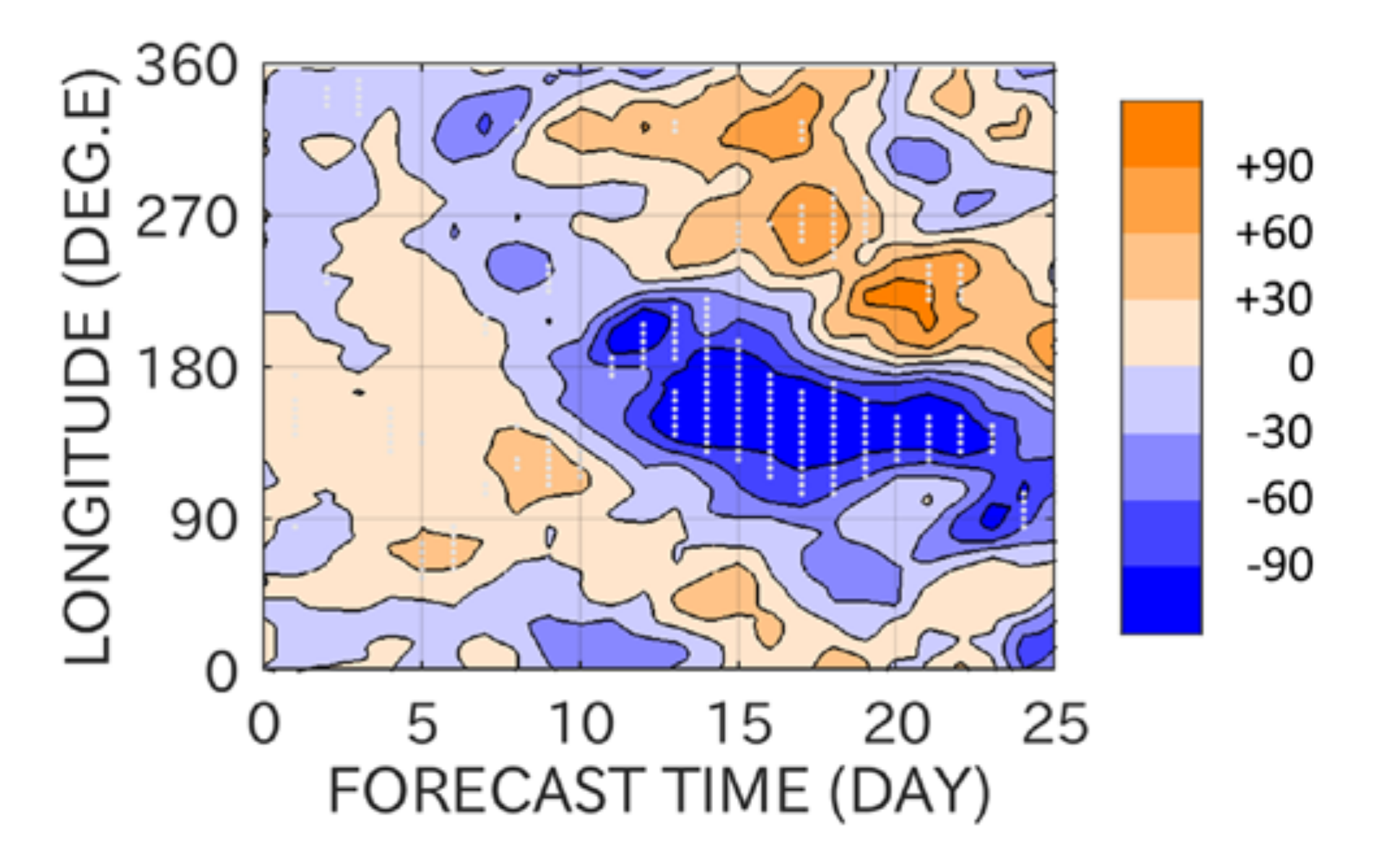
3.3. Second Cluster
4. Summary and Discussion
Funding
Acknowledgments
Conflicts of Interest
References
- Tripathi, O.P.; Baldwin, M.; Charlton-Perez, A.; Charron, M.; Stephen, D.; Gerber, E.; Harrison, R.G.; Jackson, D.R.; Kim, B.; Kuroda, Y.; et al. The predictability of the extratropical stratosphere on monthly time-scales and its impact on the skill of tropospheric forecasts. Q. J. R. Meteorol. Soc. 2015, 987–1003. [Google Scholar] [CrossRef]
- Butler, A.; Charlton-Perez, A.; Domeisen, D.I.V.; Garfinkel, C.; Gerber, E.P.; Hitchcock, P.; Karpechko, A.Y.; Maycock, A.C.; Sigmond, M.; Simpson, I.; et al. Sub-Seasonal Predictability and the Stratosphere; Elsevier Inc.: Amsterdam, The Netherlands, 2019; ISBN 9780128117149. [Google Scholar]
- Baldwin, M.P.; Dunkerton, T.J. Stratospheric harbingers of anomalous weather regimes. Science 2001, 294, 581–584. [Google Scholar] [CrossRef] [PubMed]
- Andrews, D.G.; Holton, J.R.; Leovy, C.B. Middle Atmosphere Dynamics; Academic Press: Cambridge, MA, USA, 1987. [Google Scholar]
- Baldwin, M.P.; Ayarzag, B.; Birner, T.; Butchart, N.; Butler, A.H.; Charlton-Perez, A.J.; Domeisen, D.I.V.; Garfinkel, C.I.; Garny, H.; Gerber, E.P.; et al. Sudden Stratospheric Warmings. Rev. Geophys. 2020. submitted. [Google Scholar]
- Charlton, A.J.; Polvani, L.M. A new look at stratospheric sudden warmings. Part I: Climatology and modeling benchmarks. J. Clim. 2007, 20, 449–469. [Google Scholar] [CrossRef]
- Butler, A.H.; Seidel, D.J.; Hardiman, S.C.; Butchart, N.; Birner, T.; Match, A. Defining sudden stratospheric warmings. Bull. Am. Meteorol. Soc. 2015, 96, 1913–1928. [Google Scholar] [CrossRef]
- Rao, J.; Ren, R.; Chen, H.; Yu, Y.; Zhou, Y. The Stratospheric Sudden Warming Event in February 2018 and its Prediction by a Climate System Model. J. Geophys. Res. Atmos. 2018, 123, 13332–13345. [Google Scholar] [CrossRef]
- Vitart, F.; Ardilouze, C.; Bonet, A.; Brookshaw, A.; Chen, M.; Codorean, C.; Déqué, M.; Ferranti, L.; Fucile, E.; Fuentes, M.; et al. The subseasonal to seasonal (S2S) prediction project database. Bull. Am. Meteorol. Soc. 2017, 98, 163–173. [Google Scholar] [CrossRef]
- Karpechko, A.Y.; Charlton-Perez, A.; Balmaseda, M.; Tyrrell, N.; Vitart, F. Predicting Sudden Stratospheric Warming 2018 and Its Climate Impacts with a Multimodel Ensemble. Geophys. Res. Lett. 2018, 45, 13538–13546. [Google Scholar] [CrossRef] [Green Version]
- Lee, S.H.; Charlton-Perez, A.J.; Furtado, J.C.; Woolnough, S.J. Abrupt Stratospheric Vortex Weakening Associated With North Atlantic Anticyclonic Wave Breaking. J. Geophys. Res. Atmos. 2019, 124, 8563–8575. [Google Scholar] [CrossRef] [Green Version]
- Peings, Y. Ural Blocking as a Driver of Early-Winter Stratospheric Warmings. Geophys. Res. Lett. 2019, 46, 5460–5468. [Google Scholar] [CrossRef]
- Taguchi, M. Comparison of Subseasonal-to-Seasonal Model Forecasts for Major Stratospheric Sudden Warmings. J. Geophys. Res. Atmos. 2018, 123, 10231–10247. [Google Scholar] [CrossRef]
- Taguchi, M. Verification of Subseasonal-to-Seasonal Forecasts for Major Stratospheric Sudden Warmings in Northern Winter from 1998/99 to 2012/13. Adv. Atmos. Sci. 2020, 37, 250–258. [Google Scholar] [CrossRef]
- Domeisen, D.I.V.; Butler, A.H.; Charlton-Perez, A.J.; Ayarzagüena, B.; Baldwin, M.P.; Dunn-Sigouin, E.; Furtado, J.C.; Garfinkel, C.I.; Hitchcock, P.; Karpechko, A.Y.; et al. The Role of the Stratosphere in Subseasonal to Seasonal Prediction: 1. Predictability of the Stratosphere. J. Geophys. Res. Atmos. 2020, 125, 1–17. [Google Scholar] [CrossRef]
- Rao, J.; Garfinkel, C.I.; Chen, H.; White, I.P. The 2019 New Year Stratospheric Sudden Warming and Its Real-Time Predictions in Multiple S2S Models. J. Geophys. Res. Atmos. 2019, 124, 11155–11174. [Google Scholar] [CrossRef]
- Rao, J.; Garfinkel, C.I.; White, I.P.; Schwartz, C. The Southern Hemisphere Minor Sudden Stratospheric Warming in September 2019 and its predictions in S2S Models. J. Geophys. Res. Atmos. 2020, 1–19. [Google Scholar] [CrossRef]
- Butler, A.H.; Charlton-Perez, A.; Domeisen, D.I.V.; Simpson, I.R.; Sjoberg, J. Predictability of Northern Hemisphere Final Stratospheric Warmings and Their Surface Impacts. Geophys. Res. Lett. 2019, 46, 10578–10588. [Google Scholar] [CrossRef]
- Kautz, L.A.; Polichtchouk, I.; Birner, T.; Garny, H.; Pinto, J.G. Enhanced extended-range predictability of the 2018 late-winter Eurasian cold spell due to the stratosphere. Q. J. R. Meteorol. Soc. 2020, 146, 1040–1055. [Google Scholar] [CrossRef] [Green Version]
- Rao, J.; Garfinkel, C.I.; White, I.P. Predicting the Downward and Surface Influence of the February 2018 and January 2019 Sudden Stratospheric Warming Events in Subseasonal to Seasonal (S2S) Models. J. Geophys. Res. Atmos. 2020, 125. [Google Scholar] [CrossRef] [Green Version]
- Taguchi, M. Predictability of Major Stratospheric Sudden Warmings of the Vortex Split Type: Case Study of the 2002 Southern Event and the 2009 and 1989 Northern Events. J. Atmos. Sci. 2014, 71, 2886–2904. [Google Scholar] [CrossRef]
- Taguchi, M. Predictability of major stratospheric sudden warmings: Analysis results from JMA operational 1-month ensemble predictions from 2001/02 to 2012/13. J. Atmos. Sci. 2016, 73, 789–806. [Google Scholar] [CrossRef]
- Kobayashi, S.; Ota, Y.; Harada, Y.; Ebita, A.; Moriya, M.; Onoda, H.; Onogi, K.; Kamahori, H.; Kobayashi, C.; Endo, H.; et al. The JRA–55 Reanalysis: General Specifications and Basic Characteristics. J. Meteorol. Soc. Jpn. Ser. II 2015, 93, 5–48. [Google Scholar] [CrossRef] [Green Version]
- Martineau, P.; Son, S.W.; Taguchi, M.; Butler, A.H. A comparison of the momentum budget in reanalysis datasets during sudden stratospheric warming events. Atmos. Chem. Phys. 2018, 18, 7169–7187. [Google Scholar] [CrossRef] [Green Version]
- Ayarzagüena, B.; Palmeiro, F.M.; Barriopedro, D.; Calvo, N.; Langematz, U.; Shibata, K. On the representation of major stratospheric warmings in reanalyses. Atmos. Chem. Phys. 2019, 19, 9469–9484. [Google Scholar] [CrossRef] [Green Version]
- Shiotani, M.; Hirota, I. Planetary wave-mean flow interaction in the stratosphere: A comparison between northern and southern hemispheres. Q. J. R. Meteorol. Soc. 1985, 111, 309–334. [Google Scholar] [CrossRef]
- Polvani, L.M.; Waugh, D.W. Upward wave activity flux as a precursor to extreme stratospheric events and subsequent anomalous surface weather regimes. J. Clim. 2004, 17, 3548–3554. [Google Scholar] [CrossRef]
- Kolstad, E.W.; Charlton-Perez, A.J. Observed and simulated precursors of stratospheric polar vortex anomalies in the Northern Hemisphere. Clim. Dyn. 2011, 37, 1443–1456. [Google Scholar] [CrossRef] [Green Version]
- Cohen, J.; Jones, J. Tropospheric precursors and stratospheric warmings. J. Clim. 2011, 24, 6562–6572. [Google Scholar] [CrossRef] [Green Version]
- Garfinkel, C.I.; Feldstein, S.B.; Waugh, D.W.; Yoo, C.; Lee, S. Observed connection between stratospheric sudden warmings and the Madden-Julian Oscillation. Geophys. Res. Lett. 2012, 39, 1–5. [Google Scholar] [CrossRef] [Green Version]
- Garfinkel, C.I.; Schwartz, C. MJO-Related Tropical Convection Anomalies Lead to More Accurate Stratospheric Vortex Variability in Subseasonal Forecast Models. Geophys. Res. Lett. 2017, 44, 10054–10062. [Google Scholar] [CrossRef]


| First Cluster | Second Cluster | |
|---|---|---|
| Reference date (RD) | 9 December | 1 February |
| Initial date of target MSSW ensemble Forecast time to RD | 11/27 (N27) 12 days | 01/11 (J11) 21 days |
| Initial dates of non-MSSW ensembles for comparison | 11/16 (N16) 12/04 (D04) | 12/28 (D28) 01/18 (J18) |
© 2020 by the author. Licensee MDPI, Basel, Switzerland. This article is an open access article distributed under the terms and conditions of the Creative Commons Attribution (CC BY) license (http://creativecommons.org/licenses/by/4.0/).
Share and Cite
Taguchi, M. A Study of False Alarms of a Major Sudden Stratospheric Warming by Real-Time Subseasonal-to-Seasonal Forecasts for the 2017/2018 Northern Winter. Atmosphere 2020, 11, 875. https://doi.org/10.3390/atmos11080875
Taguchi M. A Study of False Alarms of a Major Sudden Stratospheric Warming by Real-Time Subseasonal-to-Seasonal Forecasts for the 2017/2018 Northern Winter. Atmosphere. 2020; 11(8):875. https://doi.org/10.3390/atmos11080875
Chicago/Turabian StyleTaguchi, Masakazu. 2020. "A Study of False Alarms of a Major Sudden Stratospheric Warming by Real-Time Subseasonal-to-Seasonal Forecasts for the 2017/2018 Northern Winter" Atmosphere 11, no. 8: 875. https://doi.org/10.3390/atmos11080875