
Row Detection BASED Navigation and Guidance for Agricultural Robots and Autonomous Vehicles in Row-Crop Fields: Methods and Applications


Abstract
:1. Introduction
2. Sensors and Systems for Crop-Row Detection
2.1. Monocular Cameras
2.2. Binocular Cameras
2.3. RGB-D Cameras
2.4. Panorama Cameras
2.5. Spectral Imaging Systems
2.6. LiDAR Sensors
2.7. Multi-Sensor Fusion Systems
3. Methods and Algorithms for Crop-Row Detection
3.1. Traditional Methods
3.1.1. Hough Transform (HT)
3.1.2. Linear Regression Method (LRM)
3.1.3. Horizontal Strips Method
3.1.4. Blob Analysis (BA)
3.1.5. Random Sample Consensus (RANSAC)
3.1.6. Frequency Analysis
3.2. Machine Learning Methods
3.2.1. Clustering
3.2.2. Deep Learning
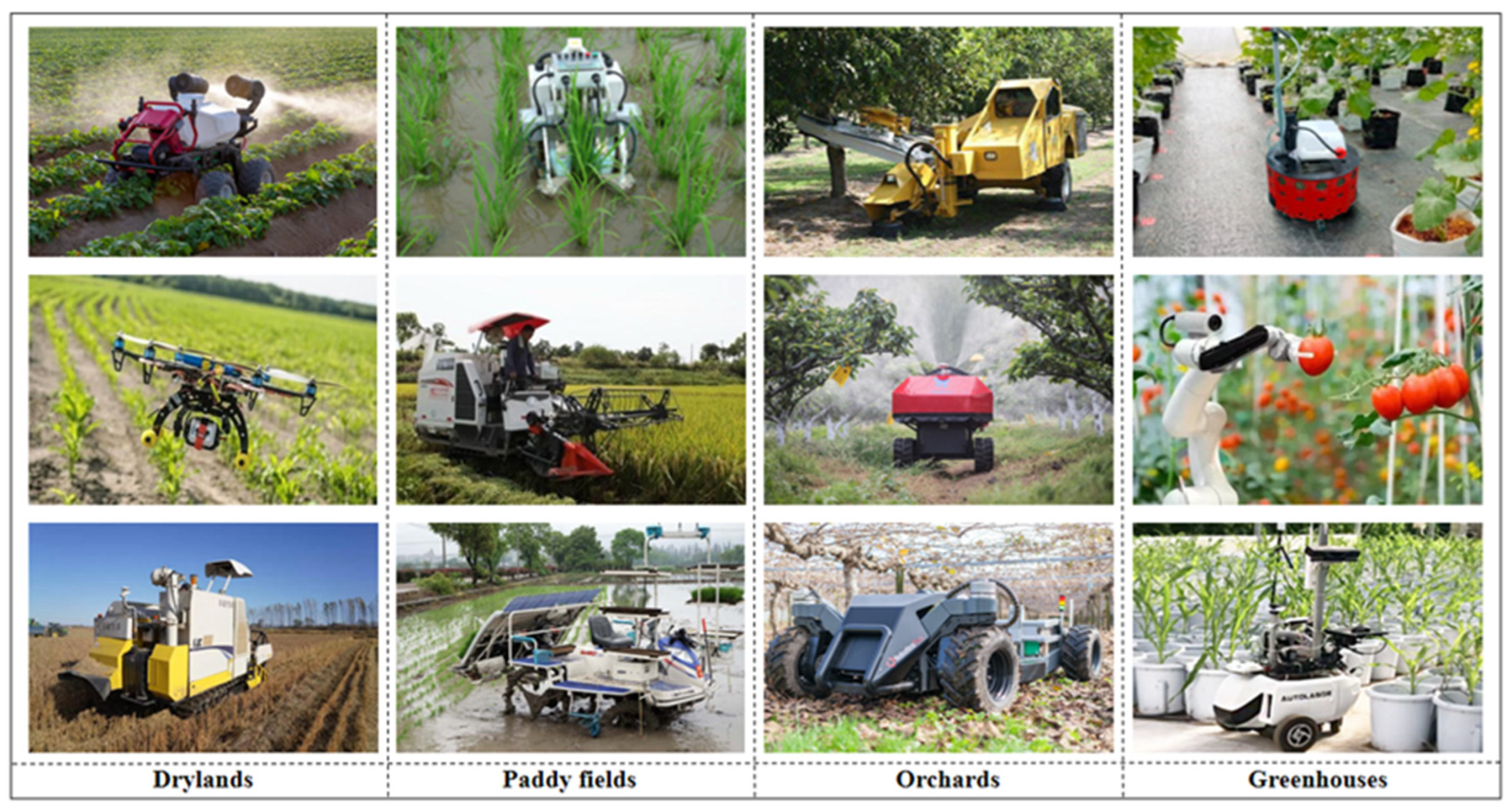
4. Applications of Row Detection Based Navigation in Row-Crop Fields
4.1. Applications of Row Detection in Drylands
4.1.1. Row Detection for Irrigation
4.1.2. Row Detection for Weeding
4.1.3. Row Detection for Harvesting
4.2. Applications of Row Detection in Paddy Fields
4.2.1. Row Detection for Transplanting
4.2.2. Row Detection for Harvesting
4.2.3. Row Detection for Weeding
4.3. Applications of Row Detection in Orchards
4.3.1. Row Detection for Picking
4.3.2. Row Detection for Spraying
4.4. Applications of Row Detection in Greenhouses
4.4.1. Row Detection for Inspection
4.4.2. Row Detection for Spraying
5. Conclusions
Author Contributions
Funding
Data Availability Statement
Conflicts of Interest
References
- Maddikunta, P.K.R.; Hakak, S.; Alazab, M.; Bhattacharya, S.; Gadekallu, T.R.; Khan, W.Z.; Pham, Q.V. Unmanned aerial vehicles in smart agriculture: Applications, requirements, and challenges. IEEE Sens. J. 2021, 21, 17608–17619. [Google Scholar] [CrossRef]
- Subeesh, A.; Mehta, C.R. Automation and digitization of agriculture using artificial intelligence and internet of things. Artif. Intell. Agric. 2021, 5, 278–291. [Google Scholar] [CrossRef]
- Karkee, M. Fundamentals of Agricultural and Field Robotics; Zhang, Q., Ed.; Springer International Publishing: Cham, Switzerland, 2021. [Google Scholar]
- Plessen, M.G. Freeform path fitting for the minimisation of the number of transitions between headland path and interior lanes within agricultural fields. Artif. Intell. Agric. 2021, 5, 233–239. [Google Scholar] [CrossRef]
- Shalal, N.; Low, T.; McCarthy, C.; Hancock, N. A preliminary evaluation of vision and laser sensing for tree trunk detection and orchard mapping. In Proceedings of the Australasian Conference on Robotics and Automation (ACRA 2013), Sydney, Australia, 2–4 December 2013; pp. 1–10, Australasian Robotics and Automation Association. [Google Scholar]
- McCarthy, C.L.; Hancock, N.H.; Raine, S.R. Applied machine vision of plants: A review with implications for field deployment in automated farming operations. Intell. Serv. Robot. 2010, 3, 209–217. [Google Scholar] [CrossRef] [Green Version]
- Rocha, B.M.; Vieira, G.S.; Fonseca, A.U.; Sousa, N.M.; Pedrini, H.; Soares, F. Detection of Curved Rows and Gaps in Aerial Images of Sugarcane Field Using Image Processing Techniques. IEEE Can. J. Electr. Comput. Eng. 2022, 45, 303–310. [Google Scholar] [CrossRef]
- Singh, N.; Tewari, V.K.; Biswas, P.K.; Pareek, C.M.; Dhruw, L.K. Image processing algorithms for in-field cotton boll detection in natural lighting conditions. Artif. Intell. Agric. 2021, 5, 142–156. [Google Scholar] [CrossRef]
- Emmi, L.; Gonzalez-de-Soto, M.; Pajares, G.; Gonzalez-de-Santos, P. Integrating sensory/actuation systems in agricultural vehicles. Sensors 2014, 14, 4014–4049. [Google Scholar] [CrossRef]
- Bonadies, S.; Gadsden, S.A. An overview of autonomous crop row navigation strategies for unmanned ground vehicles. Eng. Agric. Environ. Food 2019, 12, 24–31. [Google Scholar] [CrossRef]
- Vázquez-Arellano, M.; Griepentrog, H.W.; Reiser, D.; Paraforos, D.S. 3-D imaging systems for agricultural applications—A review. Sensors 2016, 16, 618. [Google Scholar] [CrossRef] [Green Version]
- Tian, H.; Wang, T.; Liu, Y.; Qiao, X.; Li, Y. Computer vision technology in agricultural automation—A review. Inf. Process. Agric. 2020, 7, 1–19. [Google Scholar] [CrossRef]
- English, A.; Ross, P.; Ball, D.; Corke, P. Vision based guidance for robot navigation in agriculture. In Proceedings of the 2014 IEEE International Conference on Robotics and Automation (ICRA), Beijing, China, 20–21 May 2014; pp. 1693–1698. [Google Scholar]
- Zhai, Z.; Zhu, Z.; Du, Y.; Zhang, S.; Mao, E. Method for detecting crop rows based on binocular vision with Census transformation. Trans. Chin. Soc. Agric. Eng. 2016, 32, 205–213. [Google Scholar]
- Tang, Y.; Chen, M.; Wang, C.; Luo, L.; Li, J.; Lian, G.; Zou, X. Recognition and localization methods for vision-based fruit picking robots: A review. Front. Plant Sci. 2020, 11, 510. [Google Scholar] [CrossRef]
- Pajares, G.; García-Santillán, I.; Campos, Y.; Montalvo, M.; Guerrero, J.M.; Emmi, L.; Gonzalez-de-Santos, P. Machine-vision systems selection for agricultural vehicles: A guide. J. Imaging 2016, 2, 34. [Google Scholar] [CrossRef] [Green Version]
- Zheng, Y.Y.; Kong, J.L.; Jin, X.B.; Wang, X.Y.; Su, T.L.; Zuo, M. CropDeep: The crop vision dataset for deep-learning-based classification and detection in precision agriculture. Sensors 2019, 19, 1058. [Google Scholar] [CrossRef] [PubMed] [Green Version]
- Fayyad, J.; Jaradat, M.A.; Gruyer, D.; Najjaran, H. Deep learning sensor fusion for autonomous vehicle perception and localization: A review. Sensors 2020, 20, 4220. [Google Scholar] [CrossRef] [PubMed]
- R Shamshiri, R.; Weltzien, C.; Hameed, I.A.; J Yule, I.; E Grift, T.; Balasundram, S.K.; Chowdhary, G. Research and development in agricultural robotics: A perspective of digital farming. Int. J. Agric. Biol. Eng. 2018, 11, 1–14. [Google Scholar] [CrossRef]
- Han, X.; Xu, L.; Peng, Y.; Wang, Z. Trend of Intelligent Robot Application Based on Intelligent Agriculture System. In Proceedings of the 2021 3rd International Conference on Artificial Intelligence and Advanced Manufacture (AIAM), Manchester, UK, 23–25 October 2021; pp. 205–209. [Google Scholar]
- Delmerico, J.; Scaramuzza, D. A benchmark comparison of monocular visual-inertial odometry algorithms for flying robots. In Proceedings of the 2018 IEEE International Conference on Robotics and Automation (ICRA), Brisbane, QLD, Australia, 21–25 May 2018; pp. 2502–2509. [Google Scholar]
- Aharchi, M.; Ait Kbir, M. A review on 3D reconstruction techniques from 2D images. In Proceedings of the 4th International Conference on Smart City Applications (SCA‘19), Casablanca, Morocco, 2–4 October 2019; Springer International Publishing: Berlin/Heidelberg, Germany, 2020; pp. 510–522, Innovations in Smart Cities Applications Edition 3. [Google Scholar]
- Huang, R.; Yamazato, T. A Review on Image Sensor Communication and Its Applications to Vehicles. Photonics 2023, 10, 617. [Google Scholar] [CrossRef]
- Ai, C.; Geng, D.; Qi, Z.; Zheng, L.; Feng, Z. Research on AGV Navigation System Based on Binocular Vision. In Proceedings of the 2021 IEEE International Conference on Real-time Computing and Robotics (RCAR), Xining, China, 15–19 July 2021; pp. 851–856. [Google Scholar]
- Chen, Y.; Hou, C.; Tang, Y.; Zhuang, J.; Lin, J.; He, Y.; Luo, S. Citrus tree segmentation from UAV images based on monocular machine vision in a natural orchard environment. Sensors 2019, 19, 5558. [Google Scholar] [CrossRef] [Green Version]
- Zhou, C.; Ye, H.; Hu, J.; Shi, X.; Hua, S.; Yue, J.; Yang, G. Automated counting of rice panicle by applying deep learning model to images from unmanned aerial vehicle platform. Sensors 2019, 19, 3106. [Google Scholar] [CrossRef] [Green Version]
- Ball, D.; Upcroft, B.; Wyeth, G.; Corke, P.; English, A.; Ross, P.; Bate, A. Vision-based obstacle detection and navigation for an agricultural robot. J. Field Robot. 2016, 33, 1107–1130. [Google Scholar] [CrossRef]
- Vrochidou, E.; Oustadakis, D.; Kefalas, A.; Papakostas, G.A. Computer vision in self-steering tractors. Machines 2022, 10, 129. [Google Scholar] [CrossRef]
- Ren, J.; Guan, F.; Wang, T.; Qian, B.; Luo, C.; Cai, G.; Li, X. High Precision Calibration Algorithm for Binocular Stereo Vision Camera using Deep Reinforcement Learning. Comput. Intell. Neurosci. 2022, 2022, 6596868. [Google Scholar] [CrossRef]
- Königshof, H.; Salscheider, N.O.; Stiller, C. Realtime 3d object detection for automated driving using stereo vision and semantic information. In Proceedings of the 2019 IEEE Intelligent Transportation Systems Conference (ITSC), Auckland, New Zealand, 27–30 October 2019; pp. 1405–1410. [Google Scholar]
- Kneip, J.; Fleischmann, P.; Berns, K. Crop edge detection based on stereo vision. Robot. Auton. Syst. 2020, 123, 103323. [Google Scholar] [CrossRef]
- Lati, R.N.; Filin, S.; Eizenberg, H. Plant growth parameter estimation from sparse 3D reconstruction based on highly-textured feature points. Precis. Agric. 2013, 14, 586–605. [Google Scholar] [CrossRef]
- Aghi, D.; Mazzia, V.; Chiaberge, M. Local motion planner for autonomous navigation in vineyards with a RGB-D camera-based algorithm and deep learning synergy. Machines 2020, 8, 27. [Google Scholar] [CrossRef]
- Giancola, S.; Valenti, M.; Sala, R. A Survey on 3D Cameras: Metrological Comparison of Time-of-Flight, Structured-Light and Active Stereoscopy Technologies; Springer Nature: Berlin/Heidelberg, Germany, 2018. [Google Scholar]
- Rosell-Polo, J.R.; Cheein, F.A.; Gregorio, E.; Andújar, D.; Puigdomènech, L.; Masip, J.; Escolà, A. Advances in structured light sensors applications in precision agriculture and livestock farming. Adv. Agron. 2015, 133, 71–112. [Google Scholar]
- Wu, D.; Chen, T.; Li, A. A high precision approach to calibrate a structured light vision sensor in a robot-based three-dimensional measurement system. Sensors 2016, 16, 1388. [Google Scholar] [CrossRef]
- Zanuttigh, P.; Marin, G.; Dal Mutto, C.; Dominio, F.; Minto, L.; Cortelazzo, G.M. Time-of-flight and structured light depth cameras. In Technology and Applications; Springer International: Berlin/Heidelberg, Germany, 2016. [Google Scholar] [CrossRef] [Green Version]
- Condotta, I.C.; Brown-Brandl, T.M.; Pitla, S.K.; Stinn, J.P.; Silva-Miranda, K.O. Evaluation of low-cost depth cameras for agricultural applications. Comput. Electron. Agric. 2020, 173, 105394. [Google Scholar] [CrossRef]
- Shahnewaz, A.; Pandey, A.K. Color and depth sensing sensor technologies for robotics and machine vision. In Machine Vision and Navigation; Springer: Cham, Switzerland, 2020; pp. 59–86. [Google Scholar]
- Chen, M.K.; Liu, X.; Wu, Y.; Zhang, J.; Yuan, J.; Zhang, Z.; Tsai, D.P. A Meta-Device for Intelligent Depth Perception. Adv. Mater. 2022, 9, 2107465. [Google Scholar] [CrossRef]
- Qiu, R.; Zhang, M.; He, Y. Field estimation of maize plant height at jointing stage using an RGB-D camera. Crop J. 2022, 10, 1274–1283. [Google Scholar] [CrossRef]
- Milella, A.; Marani, R.; Petitti, A.; Reina, G. In-field high throughput grapevine phenotyping with a consumer-grade depth camera. Comput. Electron. Agric. 2019, 156, 293–306. [Google Scholar] [CrossRef]
- Birklbauer, C.; Bimber, O. Panorama light-field imaging. In Computer Graphics Forum; Wiley Online Library: Hoboken, NJ, USA, 2014; Volume 33, pp. 43–52. [Google Scholar]
- Gao, S.; Yang, K.; Shi, H.; Wang, K.; Bai, J. Review on Panoramic Imaging and Its Applications in Scene Understanding. arXiv 2014, arXiv:2205.05570. [Google Scholar] [CrossRef]
- Lai, J.S.; Peng, Y.C.; Chang, M.J.; Huang, J.Y. Panoramic Mapping with Information Technologies for Supporting Engineering Education: A Preliminary Exploration. ISPRS Int. J. Geo-Inf. 2020, 9, 689. [Google Scholar] [CrossRef]
- Yang, K.; Hu, X.; Chen, H.; Xiang, K.; Wang, K.; Stiefelhagen, R. Ds-pass: Detail-sensitive panoramic annular semantic segmentation through swaftnet for surrounding sensing. In Proceedings of the 2020 IEEE Intelligent Vehicles Symposium (IV), Las Vegas, NV, USA, 19 October–13 November 2020; pp. 457–464. [Google Scholar]
- Häne, C.; Heng, L.; Lee, G.H.; Fraundorfer, F.; Furgale, P.; Sattler, T.; Pollefeys, M. 3D visual perception for self-driving cars using a multi-camera system: Calibration, mapping, localization, and obstacle detection. Image Vis. Comput. 2017, 68, 14–27. [Google Scholar] [CrossRef] [Green Version]
- Kumar, V.R.; Eising, C.; Witt, C.; Yogamani, S. Surround-view Fisheye Camera Perception for Automated Driving: Overview, Survey and Challenges. arXiv 2022, arXiv:2205.13281. [Google Scholar] [CrossRef]
- Chan, S.; Zhou, X.; Huang, C.; Chen, S.; Li, Y.F. An improved method for fisheye camera calibration and distortion correction. In Proceedings of the 2016 International Conference on Advanced Robotics and Mechatronics (ICARM), Macau, China, 18–20 August 2016; pp. 579–584. [Google Scholar]
- Signoroni, A.; Savardi, M.; Baronio, A.; Benini, S. Deep learning meets hyperspectral image analysis: A multidisciplinary review. J. Imaging 2019, 5, 52. [Google Scholar] [CrossRef] [Green Version]
- Liu, X.; Jiang, Z.; Wang, T.; Cai, F.; Wang, D. Fast hyperspectral imager driven by a low-cost and compact galvo-mirror. Optik 2020, 224, 165716. [Google Scholar] [CrossRef]
- Shaikh, M.S.; Jaferzadeh, K.; Thörnberg, B.; Casselgren, J. Calibration of a hyper-spectral imaging system using a low-cost reference. Sensors 2021, 21, 3738. [Google Scholar] [CrossRef]
- Lottes, P.; Hoeferlin, M.; Sander, S.; Müter, M.; Schulze, P.; Stachniss, L.C. An effective classification system for separating sugar beets and weeds for precision farming applications. In Proceedings of the 2016 IEEE International Conference on Robotics and Automation (ICRA), Stockholm, Sweden, 16–21 May 2016; pp. 5157–5163. [Google Scholar]
- Louargant, M.; Jones, G.; Faroux, R.; Paoli, J.N.; Maillot, T.; Gée, C.; Villette, S. Unsupervised classification algorithm for early weed detection in row-crops by combining spatial and spectral information. Remote Sens. 2018, 10, 761. [Google Scholar] [CrossRef] [Green Version]
- Su, W.H. Crop plant signaling for real-time plant identification in smart farm: A systematic review and new concept in artificial intelligence for automated weed control. Artif. Intell. Agric. 2020, 4, 262–271. [Google Scholar] [CrossRef]
- Adão, T.; Hruška, J.; Pádua, L.; Bessa, J.; Peres, E.; Morais, R.; Sousa, J.J. Hyperspectral imaging: A review on UAV-based sensors, data processing and applications for agriculture and forestry. Remote Sens. 2017, 9, 1110. [Google Scholar] [CrossRef] [Green Version]
- Wang, X.; Pan, H.; Guo, K.; Yang, X.; Luo, S. The evolution of LiDAR and its application in high precision measurement. IOP Conf. Ser.: Earth Environ. Sci. 2020, 502, 012008. [Google Scholar] [CrossRef]
- Chazette, P.; Totems, J.; Hespel, L.; Bailly, J.S. Principle and physics of the LiDAR measurement. In Optical Remote Sensing of Land Surface; Elsevier: Amsterdam, The Netherlands, 2016; pp. 201–247. [Google Scholar]
- Moreno, H.; Valero, C.; Bengochea-Guevara, J.M.; Ribeiro, Á.; Garrido-Izard, M.; Andújar, D. On-ground vineyard reconstruction using a LiDAR-based automated system. Sensors 2020, 20, 1102. [Google Scholar] [CrossRef] [PubMed] [Green Version]
- Liu, J.; Sun, Q.; Fan, Z.; Jia, Y. TOF lidar development in autonomous vehicle. In Proceedings of the 2018 IEEE 3rd Optoelectronics Global Conference (OGC), Shenzhen, China, 4–7 September 2018; pp. 185–190. [Google Scholar]
- Wang, T.; Chen, B.; Zhang, Z.; Li, H.; Zhang, M. Applications of machine vision in agricultural robot navigation: A review. Comput. Electron. Agric. 2022, 198, 107085. [Google Scholar] [CrossRef]
- Gao, X.; Li, J.; Fan, L.; Zhou, Q.; Yin, K.; Wang, J.; Wang, Z. Review of wheeled mobile robots’ navigation problems and application prospects in agriculture. IEEE Access 2018, 6, 49248–49268. [Google Scholar] [CrossRef]
- Qu, Y.; Yang, M.; Zhang, J.; Xie, W.; Qiang, B.; Chen, J. An outline of multi-sensor fusion methods for mobile agents indoor navigation. Sensors 2021, 21, 1605. [Google Scholar] [CrossRef]
- Shalal, N.; Low, T.; McCarthy, C.; Hancock, N. A review of autonomous navigation systems in agricultural environments. In Proceedings of the SEAg 2013: Innovative Agricultural Technologies for a Sustainable Future, Barton, Australia, 22–25 September 2013. [Google Scholar]
- Benet, B.; Lenain, R. Multi-sensor fusion method for crop row tracking and traversability operations. In Proceedings of the Conférence AXEMA-EURAGENG 2017, Paris, France, 10–11 February 2017; p. 10. [Google Scholar]
- Shaikh, T.A.; Rasool, T.; Lone, F.R. Towards leveraging the role of machine learning and artificial intelligence in precision agriculture and smart farming. Comput. Electron. Agric. 2022, 198, 107119. [Google Scholar] [CrossRef]
- Yan, Y.; Zhang, B.; Zhou, J.; Zhang, Y.; Liu, X.A. Real-Time Localization and Mapping Utilizing Multi-Sensor Fusion and Visual–IMU–Wheel Odometry for Agricultural Robots in Unstructured, Dynamic and GPS-Denied Greenhouse Environments. Agronomy 2022, 12, 1740. [Google Scholar] [CrossRef]
- Kolar, P.; Benavidez, P.; Jamshidi, M. Survey of datafusion techniques for laser and vision based sensor integration for autonomous navigation. Sensors 2020, 20, 2180. [Google Scholar] [CrossRef] [Green Version]
- de Silva, R.; Cielniak, G.; Gao, J. Towards agricultural autonomy: Crop row detection under varying field conditions using deep learning. arXiv 2021, arXiv:2109.08247. [Google Scholar]
- Meng, Q.; Qiu, R.; He, J.; Zhang, M.; Ma, X.; Liu, G. Development of agricultural implement system based on machine vision and fuzzy control. Comput. Electron. Agric. 2015, 112, 128–138. [Google Scholar] [CrossRef]
- Xu, Z.; Shin, B.S.; Klette, R. Closed form line-segment extraction using the Hough transform. Pattern Recognit. 2015, 48, 4012–4023. [Google Scholar] [CrossRef]
- Marzougui, M.; Alasiry, A.; Kortli, Y.; Baili, J. A lane tracking method based on progressive probabilistic Hough transform. IEEE Access 2020, 8, 84893–84905. [Google Scholar] [CrossRef]
- Chung, K.L.; Huang, Y.H.; Tsai, S.R. Orientation-based discrete Hough transform for line detection with low computational complexity. Appl. Math. Comput. 2014, 237, 430–437. [Google Scholar] [CrossRef]
- Chai, Y.; Wei, S.J.; Li, X.C. The multi-scale Hough transform lane detection method based on the algorithm of Otsu and Canny. Adv. Mater. Res. 2014, 1042, 126–130. [Google Scholar] [CrossRef]
- Akinwande, M.O.; Dikko, H.G.; Samson, A. Variance inflation factor: As a condition for the inclusion of suppressor variable(s) in regression analysis. Open J. Stat. 2015, 5, 754. [Google Scholar] [CrossRef] [Green Version]
- Andargie, A.A.; Rao, K.S. Estimation of a linear model with two-parameter symmetric platykurtic distributed errors. J. Uncertain. Anal. Appl. 2013, 1, 13. [Google Scholar] [CrossRef] [Green Version]
- Milioto, A.; Lottes, P.; Stachniss, C. Real-time semantic segmentation of crop and weed for precision agriculture robots leveraging background knowledge in CNNs. In Proceedings of the 2018 IEEE International Conference on Robotics and Automation (ICRA), Brisbane, QLD, Australia, 21–25 May 2018; pp. 2229–2235. [Google Scholar]
- Yang, Z.; Yang, Y.; Li, C.; Zhou, Y.; Zhang, X.; Yu, Y.; Liu, D. Tasseled Crop Rows Detection Based on Micro-Region of Interest and Logarithmic Transformation. Front. Plant Sci. 2022, 13, 916474. [Google Scholar] [CrossRef]
- Zheng, L.Y.; Xu, J.X. Multi-crop-row detection based on strip analysis. In Proceedings of the 2014 International Conference on Machine Learning and Cybernetics, Lanzhou, China, 13–16 July 2014; Volume 2, pp. 611–614. [Google Scholar]
- Zhou, Y.; Yang, Y.; Zhang, B.; Wen, X.; Yue, X.; Chen, L. Autonomous detection of crop rows based on adaptive multi-ROI in maize fields. Int. J. Agric. Biol. Eng. 2021, 14, 217–225. [Google Scholar] [CrossRef]
- Zhai, Z.; Zhu, Z.; Du, Y.; Song, Z.; Mao, E. Multi-crop-row detection algorithm based on binocular vision. Biosyst. Eng. 2016, 150, 89–103. [Google Scholar] [CrossRef]
- Benson, E.R.; Reid, J.F.; Zhang, Q. Machine vision–based guidance system for an agricultural small–grain harvester. Trans. ASAE 2003, 46, 1255. [Google Scholar] [CrossRef]
- Fontaine, V.; Crowe, T.G. Development of line-detection algorithms for local positioning in densely seeded crops. Can. Biosyst. Eng. 2006, 48, 7. [Google Scholar]
- Wang, A.; Zhang, W.; Wei, X. A review on weed detection using ground-based machine vision and image processing techniques. Comput. Electron. Agric. 2019, 158, 226–240. [Google Scholar] [CrossRef]
- Zhou, M.; Xia, J.; Yang, F.; Zheng, K.; Hu, M.; Li, D.; Zhang, S. Design and experiment of visual navigated UGV for orchard based on Hough matrix and RANSAC. Int. J. Agric. Biol. Eng. 2021, 14, 176–184. [Google Scholar] [CrossRef]
- Khan, N.; Rajendran, V.P.; Al Hasan, M.; Anwar, S. Clustering Algorithm Based Straight and Curved Crop Row Detection Using Color Based Segmentation. In Proceedings of the ASME 2020 International Mechanical Engineering Congress and Exposition, Virtual, 16–19 November 2020; American Society of Mechanical Engineers: New York, NY, USA, 2020; Volume 84553, p. V07BT07A003. [Google Scholar]
- Ghahremani, M.; Williams, K.; Corke, F.; Tiddeman, B.; Liu, Y.; Wang, X.; Doonan, J.H. Direct and accurate feature extraction from 3D point clouds of plants using RANSAC. Comput. Electron. Agric. 2021, 187, 106240. [Google Scholar] [CrossRef]
- Guo, J.; Wei, Z.; Miao, D. Lane detection method based on improved RANSAC algorithm. In Proceedings of the 2015 IEEE Twelfth International Symposium on Autonomous Decentralized Systems, Taichung, Taiwan, 25–27 March 2015; pp. 285–288. [Google Scholar]
- Ma, S.; Guo, P.; You, H.; He, P.; Li, G.; Li, H. An image matching optimization algorithm based on pixel shift clustering RANSAC. Inf. Sci. 2021, 562, 452–474. [Google Scholar] [CrossRef]
- Bossu, J.; Gée, C.; Jones, G.; Truchetet, F. Wavelet transform to discriminate between crop and weed in perspective agronomic images. Comput. Electron. Agric. 2009, 65, 133–143. [Google Scholar] [CrossRef]
- Arts, L.P.; van den Broek, E.L. The fast continuous wavelet transformation (fCWT) for real-time, high-quality, noise-resistant time–frequency analysis. Nat. Comput. Sci. 2022, 2, 47–58. [Google Scholar] [CrossRef]
- Hague, T.; Tillett, N.D. A bandpass filter-based approach to crop row location and tracking. Mechatronics 2001, 11, 1–12. [Google Scholar] [CrossRef]
- García-Santillán, I.D.; Montalvo, M.; Guerrero, J.M.; Pajares, G. Automatic detection of curved and straight crop rows from images in maize fields. Biosyst. Eng. 2017, 156, 61–79. [Google Scholar] [CrossRef]
- Saxena, A.; Prasad, M.; Gupta, A.; Bharill, N.; Patel, O.P.; Tiwari, A.; Lin, C.T. A review of clustering techniques and developments. Neurocomputing 2017, 267, 664–681. [Google Scholar] [CrossRef] [Green Version]
- Vidović, I.; Scitovski, R. Center-based clustering for line detection and application to crop rows detection. Comput. Electron. Agric. 2014, 109, 212–220. [Google Scholar] [CrossRef]
- Behura, A. The cluster analysis and feature selection: Perspective of machine learning and image processing. Data Anal. Bioinform. Mach. Learn. Perspect. 2021, 10, 249–280. [Google Scholar]
- Steward, B.L.; Gai, J.; Tang, L. The use of agricultural robots in weed management and control. Robot. Autom. Improv. Agric. 2019, 44, 1–25. [Google Scholar]
- Yu, Y.; Bao, Y.; Wang, J.; Chu, H.; Zhao, N.; He, Y.; Liu, Y. Crop row segmentation and detection in paddy fields based on treble-classification otsu and double-dimensional clustering method. Remote Sens. 2021, 13, 901. [Google Scholar] [CrossRef]
- Ezugwu, A.E.; Ikotun, A.M.; Oyelade, O.O.; Abualigah, L.; Agushaka, J.O.; Eke, C.I.; Akinyelu, A.A. A comprehensive survey of clustering algorithms: State-of-the-art machine learning applications, taxonomy, challenges, and future research prospects. Eng. Appl. Artif. Intell. 2022, 110, 104743. [Google Scholar] [CrossRef]
- Lachgar, M.; Hrimech, H.; Kartit, A. Optimization techniques in deep convolutional neuronal networks applied to olive diseases classification. Artif. Intell. Agric. 2022, 6, 77–89. [Google Scholar]
- Kamilaris, A.; Prenafeta-Boldú, F.X. Deep learning in agriculture: A survey. Comput. Electron. Agric. 2018, 147, 70–90. [Google Scholar] [CrossRef] [Green Version]
- De Castro, A.I.; Torres-Sánchez, J.; Peña, J.M.; Jiménez-Brenes, F.M.; Csillik, O.; López-Granados, F. An automatic random forest-OBIA algorithm for early weed mapping between and within crop rows using UAV imagery. Remote Sens. 2018, 10, 285. [Google Scholar] [CrossRef] [Green Version]
- You, J.; Liu, W.; Lee, J. A DNN-based semantic segmentation for detecting weed and crop. Comput. Electron. Agric. 2020, 178, 105750. [Google Scholar] [CrossRef]
- Doha, R.; Al Hasan, M.; Anwar, S.; Rajendran, V. Deep learning based crop row detection with online domain adaptation. In Proceedings of the 27th ACM SIGKDD Conference on Knowledge Discovery Data Mining, Singapore, 14–18 August 2021; pp. 2773–2781. [Google Scholar]
- Picon, A.; San-Emeterio, M.G.; Bereciartua-Perez, A.; Klukas, C.; Eggers, T.; Navarra-Mestre, R. Deep learning-based segmentation of multiple species of weeds and corn crop using synthetic and real image datasets. Comput. Electron. Agric. 2022, 194, 106719. [Google Scholar] [CrossRef]
- de Silva, R.; Cielniak, G.; Wang, G.; Gao, J. Deep learning-based Crop Row Following for Infield Navigation of Agri-Robots. arXiv 2022, arXiv:2209.04278. [Google Scholar]
- Kumar, R.; Singh, M.P.; Kumar, P.; Singh, J.P. Crop Selection Method to maximize crop yield rate using machine learning technique. In Proceedings of the 2015 International Conference on Smart Technologies and Management for Computing, Communication, Controls, Energy and Materials (ICSTM), Avadi, India, 6–8 May 2015; pp. 138–145. [Google Scholar]
- Fue, K.G.; Porter, W.M.; Barnes, E.M.; Rains, G.C. An extensive review of mobile agricultural robotics for field operations: Focus on cotton harvesting. AgriEngineering 2020, 2, 150–174. [Google Scholar] [CrossRef] [Green Version]
- Sankaran, S.; Khot, L.R.; Espinoza, C.Z.; Jarolmasjed, S.; Sathuvalli, V.R.; Vandemark, G.J.; Pavek, M.J. Low-altitude, high-resolution aerial imaging systems for row and field crop phenotyping: A review. Eur. J. Agron. 2015, 70, 112–123. [Google Scholar] [CrossRef]
- Rejeb, A.; Rejeb, K.; Zailani, S.; Keogh, J.G.; Appolloni, A. Examining the interplay between artificial intelligence and the agri-food industry. Artif. Intell. Agric. 2022, 6, 111–128. [Google Scholar] [CrossRef]
- Jiang, Y.; Li, C.; Paterson, A.H.; Sun, S.; Xu, R.; Robertson, J. Quantitative analysis of cotton canopy size in field conditions using a consumer-grade RGB-D camera. Front. Plant Sci. 2018, 8, 2233. [Google Scholar] [CrossRef] [Green Version]
- Yao, Y.; Sun, J.; Tian, Y.; Zheng, C.; Liu, J. Alleviating water scarcity and poverty in drylands through telecouplings: Vegetable trade and tourism in northwest China. Sci. Total Environ. 2020, 741, 140387. [Google Scholar] [CrossRef]
- Jha, K.; Doshi, A.; Patel, P.; Shah, M. A comprehensive review on automation in agriculture using artificial intelligence. Artif. Intell. Agric. 2019, 2, 1–12. [Google Scholar] [CrossRef]
- Yu, J.; Cheng, T.; Cai, N.; Zhou, X.G.; Diao, Z.; Wang, T.; Zhang, D. Wheat Lodging Segmentation Based on Lstm_PSPNet Deep Learning Network. Drones 2023, 7, 143. [Google Scholar] [CrossRef]
- Emmi, L.; Herrera-Diaz, J.; Gonzalez-de-Santos, P. Toward Autonomous Mobile Robot Navigation in Early-Stage Crop Growth. In Proceedings of the 19th International Conference on Informatics in Control 2022, Automation and Robotics-ICINCO, Lisbon Portugal, 14–16 July 2022; pp. 411–418. [Google Scholar]
- Liang, X.; Chen, B.; Wei, C.; Zhang, X. Inter-row navigation line detection for cotton with broken rows. Plant Methods 2022, 18, 1–12. [Google Scholar] [CrossRef]
- Wei, C.; Li, H.; Shi, J.; Zhao, G.; Feng, H.; Quan, L. Row anchor selection classification method for early-stage crop row-following. Comput. Electron. Agric. 2022, 192, 106577. [Google Scholar] [CrossRef]
- Winterhalter, W.; Fleckenstein, F.; Dornhege, C.; Burgard, W. Localization for precision navigation in agricultural fields—Beyond crop row following. J. Field Robot. 2021, 38, 429–451. [Google Scholar] [CrossRef]
- Bakken, M.; Ponnambalam, V.R.; Moore, R.J.; Gjevestad, J.G.O.; From, P.J. Robot-supervised Learning of Crop Row Segmentation. In Proceedings of the 2021 IEEE International Conference on Robotics and Automation (ICRA), Xi’an, China, 30 May–5 June 2021; pp. 2185–2191. [Google Scholar]
- Xie, Y.; Chen, K.; Li, W.; Zhang, Y.; Mo, J. An Improved Adaptive Threshold RANSAC Method for Medium Tillage Crop Rows Detection. In Proceedings of the 2021 6th International Conference on Intelligent Computing and Signal Processing (ICSP), Xi’an, China, 9–11 April 2021; pp. 1282–1286. [Google Scholar]
- He, C.; Chen, Q.; Miao, Z.; Li, N.; Sun, T. Extracting the navigation path of an agricultural plant protection robot based on machine vision. In Proceedings of the 2021 40th Chinese Control Conference (CCC), Shanghai, China, 26–28 July 2021; pp. 3576–3581. [Google Scholar]
- Gai, J.; Xiang, L.; Tang, L. Using a depth camera for crop row detection and mapping for under-canopy navigation of agricultural robotic vehicle. Comput. Electron. Agric. 2021, 188, 106301. [Google Scholar] [CrossRef]
- Ahmadi, A.; Nardi, L.; Chebrolu, N.; Stachniss, C. Visual servoing-based navigation for monitoring row-crop fields. In Proceedings of the 2020 IEEE International Conference on Robotics and Automation (ICRA), Paris, France, 31 May 2020; pp. 4920–4926. [Google Scholar]
- Iqbal, J.; Xu, R.; Sun, S.; Li, C. Simulation of an autonomous mobile robot for LiDAR-based in-field phenotyping and navigation. Robotics 2020, 9, 46. [Google Scholar] [CrossRef]
- Ponnambalam, V.R.; Bakken, M.; Moore, R.J.; Glenn Omholt Gjevestad, J.; Johan From, P. Autonomous crop row guidance using adaptive multi-roi in strawberry fields. Sensors 2020, 20, 5249. [Google Scholar] [CrossRef] [PubMed]
- Velasquez, A.E.B.; Higuti, V.A.H.; Guerrero, H.B.; Gasparino, M.V.; Magalhaes, D.V.; Aroca, R.V.; Becker, M. Reactive navigation system based on H∞ control system and LiDAR readings on corn crops. Precis. Agric. 2020, 21, 349–368. [Google Scholar] [CrossRef]
- Xiuzhi, L.I.; Xiaobin, P.E.N.G.; Huimin, F.A.N.G. Navigation path detection of plant protection robot based on RANSAC algorithm. Nongye Jixie Xuebao/Trans. Chin. Soc. Agric. Mach. 2020, 51, 41–46. [Google Scholar]
- Liao, J.; Wang, Y.; Zhu, D.; Zou, Y.; Zhang, S.; Zhou, H. Automatic segmentation of crop/background based on luminance partition correction and adaptive threshold. IEEE Access 2020, 8, 202611–202622. [Google Scholar] [CrossRef]
- Simon, N.A.; Min, C.H. Neural Network Based Corn Field Furrow Detection for Autonomous Navigation in Agriculture Vehicles. In Proceedings of the 2020 IEEE International IOT, Electronics and Mechatronics Conference (IEMTRONICS), Vancouver, BC, Canada, 9–12 September 2020; pp. 1–6. [Google Scholar]
- Higuti, V.A.; Velasquez, A.E.; Magalhaes, D.V.; Becker, M.; Chowdhary, G. Under canopy light detection and ranging-based autonomous navigation. J. Field Robot. 2019, 36, 547–567. [Google Scholar] [CrossRef]
- Winterhalter, W.; Fleckenstein, F.V.; Dornhege, C.; Burgard, W. Crop row detection on tiny plants with the pattern hough transform. IEEE Robot. Autom. Lett. 2018, 3, 3394–3401. [Google Scholar] [CrossRef]
- Zhang, X.; Li, X.; Zhang, B.; Zhou, J.; Tian, G.; Xiong, Y.; Gu, B. Automated robust crop-row detection in maize fields based on position clustering algorithm and shortest path method. Comput. Electron. Agric. 2018, 154, 165–175. [Google Scholar] [CrossRef]
- Li, J.; Zhu, R.; Chen, B. Image detection and verification of visual navigation route during cotton field management period. Int. J. Agric. Biol. Eng. 2018, 11, 159–165. [Google Scholar] [CrossRef] [Green Version]
- Meng, Q.; Hao, X.; Zhang, Y.; Yang, G. Guidance line identification for agricultural mobile robot based on machine vision. In Proceedings of the 2018 IEEE 3rd Advanced Information Technology, Electronic and Automation Control Conference (IAEAC), Chongqing, China, 12–14 October 2018; pp. 1887–1893. [Google Scholar]
- Yang, S.; Mei, S.; Zhang, Y. Detection of maize navigation centerline based on machine vision. IFAC-PapersOnLine 2018, 51, 570–575. [Google Scholar] [CrossRef]
- Reiser, D.; Miguel, G.; Arellano, M.V.; Griepentrog, H.W.; Paraforos, D.S. Crop row detection in maize for developing navigation algorithms under changing plant growth stages. In Proceedings of the Robot 2015: Second Iberian Robotics Conference, Lisbon, Portugal, 19–21 November 2016; Springer: Cham, Switzerland, 2016; pp. 371–382. [Google Scholar]
- Liu, L.; Mei, T.; Niu, R.; Wang, J.; Liu, Y.; Chu, S. RBF-based monocular vision navigation for small vehicles in narrow space below maize canopy. Appl. Sci. 2016, 6, 182. [Google Scholar] [CrossRef] [Green Version]
- Jiang, G.; Wang, X.; Wang, Z.; Liu, H. Wheat rows detection at the early growth stage based on Hough transform and vanishing point. Comput. Electron. Agric. 2016, 123, 211–223. [Google Scholar] [CrossRef]
- Tu, C.; Van Wyk, B.J.; Djouani, K.; Hamam, Y.; Du, S. An efficient crop row detection method for agriculture robots. In Proceedings of the 2014 7th International Congress on Image and Signal Processing, Dalian, China, 14–16 October 2014; pp. 655–659. [Google Scholar]
- Zhu, Z.X.; He, Y.; Zhai, Z.Q.; Liu, J.Y.; Mao, E.R. Research on cotton row detection algorithm based on binocular vision. Appl. Mech. Mater. 2014, 670, 1222–1227. [Google Scholar] [CrossRef]
- Su, D.; Qiao, Y.; Kong, H.; Sukkarieh, S. Real time detection of inter-row ryegrass in wheat farms using deep learning. Biosyst. Eng. 2021, 204, 198–211. [Google Scholar] [CrossRef]
- Du, Y.; Mallajosyula, B.; Sun, D.; Chen, J.; Zhao, Z.; Rahman, M.; Jawed, M.K. A Low-cost Robot with Autonomous Recharge and Navigation for Weed Control in Fields with Narrow Row Spacing. In Proceedings of the 2021 IEEE/RSJ International Conference on Intelligent Robots and Systems (IROS), Prague, Czech Republic, 27–30 September 2021; pp. 3263–3270. [Google Scholar]
- Rabab, S.; Badenhorst, P.; Chen, Y.P.P.; Daetwyler, H.D. A template-free machine vision-based crop row detection algorithm. Precis. Agric. 2021, 22, 124–153. [Google Scholar] [CrossRef]
- Czymmek, V.; Schramm, R.; Hussmann, S. Vision based crop row detection for low cost uav imagery in organic agriculture. In Proceedings of the 2020 IEEE International Instrumentation and Measurement Technology Conference (I2MTC), Dubrovnik, Croatia, 25–28 May 2020; pp. 1–6. [Google Scholar]
- Pusdá-Chulde, M.; Giusti, A.D.; Herrera-Granda, E.; García-Santillán, I. Parallel CPU-based processing for automatic crop row detection in corn fields. In Proceedings of the XV Multidisciplinary International Congress on Science and Technology, Quito, Ecuador, 19–23 October 2020; Springer: Cham, Switzerland, 2020; pp. 239–251. [Google Scholar]
- Kulkarni, S.; Angadi, S.A.; Belagavi, V.T.U. IoT based weed detection using image processing and CNN. Int. J. Eng. Appl. Sci. Technol. 2019, 4, 606–609. [Google Scholar]
- Czymmek, V.; Harders, L.O.; Knoll, F.J.; Hussmann, S. Vision-based deep learning approach for real-time detection of weeds in organic farming. In Proceedings of the 2019 IEEE International Instrumentation and Measurement Technology Conference (I2MTC), Auckland, New Zealand, 20–23 May 2019; pp. 1–5. [Google Scholar]
- Hassanein, M.; Khedr, M.; El-Sheimy, N. Crop row detection procedure using low-cost UAV imagery system. Int. Arch. Photogramm. Remote Sens. Spat. Inf. Sci. 2019, 42, 349–356. [Google Scholar] [CrossRef] [Green Version]
- Bah, M.D.; Hafiane, A.; Canals, R. CRowNet: Deep network for crop row detection in UAV images. IEEE Access 2019, 8, 5189–5200. [Google Scholar] [CrossRef]
- Tenhunen, H.; Pahikkala, T.; Nevalainen, O.; Teuhola, J.; Mattila, H.; Tyystjärvi, E. Automatic detection of cereal rows by means of pattern recognition techniques. Comput. Electron. Agric. 2019, 162, 677–688. [Google Scholar] [CrossRef]
- García-Santillán, I.; Guerrero, J.M.; Montalvo, M.; Pajares, G. Curved and straight crop row detection by accumulation of green pixels from images in maize fields. Precis. Agric. 2018, 19, 18–41. [Google Scholar] [CrossRef]
- Kaur, M.; Min, C.H. Automatic crop furrow detection for precision agriculture. In Proceedings of the 2018 IEEE 61st International Midwest Symposium on Circuits and Systems (MWSCAS), Windsor, ON, Canada, 5–8 August 2018; pp. 520–523. [Google Scholar]
- Hamuda, E.; Mc Ginley, B.; Glavin, M.; Jones, E. Improved image processing-based crop detection using Kalman filtering and the Hungarian algorithm. Comput. Electron. Agric. 2018, 148, 37–44. [Google Scholar] [CrossRef]
- Bah, M.D.; Hafiane, A.; Canals, R. Deep learning with unsupervised data labeling for weed detection in line crops in UAV images. Remote Sens. 2018, 10, 1690. [Google Scholar] [CrossRef] [Green Version]
- Malavazi, F.B.; Guyonneau, R.; Fasquel, J.B.; Lagrange, S.; Mercier, F. LiDAR-only based navigation algorithm for an autonomous agricultural robot. Comput. Electron. Agric. 2018, 154, 71–79. [Google Scholar] [CrossRef]
- Lavania, S.; Matey, P.S. Novel method for weed classification in maize field using Otsu and PCA implementation. In Proceedings of the 2015 IEEE International Conference on Computational Intelligence Communication Technology, Ghaziabad, India, 13–14 February 2015; pp. 534–537. [Google Scholar]
- Nan, L.; Chunlong, Z.; Ziwen, C.; Zenghong, M.; Zhe, S.; Ting, Y.; Junxiong, Z. Crop positioning for robotic intra-row weeding based on machine vision. Int. J. Agric. Biol. Eng. 2015, 8, 20–29. [Google Scholar]
- Pérez-Ortiz, M.; Peña, J.M.; Gutiérrez, P.A.; Torres-Sánchez, J.; Hervás-Martínez, C.; López-Granados, F. A semi-supervised system for weed mapping in sunflower crops using unmanned aerial vehicles and a crop row detection method. Appl. Soft Comput. 2015, 37, 533–544. [Google Scholar] [CrossRef]
- Kiani, S.; Jafari, A. Crop detection and positioning in the field using discriminant analysis and neural networks based on shape features. J. Agr. Sci. Tech. 2012, 14, 755–765. [Google Scholar]
- Burgos-Artizzu, X.P.; Ribeiro, A.; Guijarro, M.; Pajares, G. Real-time image processing for crop/weed discrimination in maize fields. Comput. Electron. Agric. 2011, 75, 337–346. [Google Scholar] [CrossRef] [Green Version]
- Hemming, J.; Nieuwenhuizen, A.T.; Struik, L.E. Image Analysis System to Determine Crop Row and Plant Positions for an Intra-Row Weeding Machine. 2011, 6, pp. 1–7. Available online: https://edepot.wur.nl/180044 (accessed on 11 June 2023).
- Ota, K.; Kasahara, J.Y.L.; Yamashita, A.; Asama, H. Weed and Crop Detection by Combining Crop Row Detection and K-means Clustering in Weed Infested Agricultural Fields. In Proceedings of the 2022 IEEE/SICE International Symposium on System Integration (SII), Narvik, Norway, 9–12 January 2022; pp. 985–990. [Google Scholar]
- Cao, M.; Tang, F.; Ji, P.; Ma, F. Improved Real-Time Semantic Segmentation Network Model for Crop Vision Navigation Line Detection. Front. Plant Sci. 2022, 13, 898131. [Google Scholar] [CrossRef] [PubMed]
- Basso, M.; Pignaton de Freitas, E. A UAV guidance system using crop row detection and line follower algorithms. J. Intell. Robot. Syst. 2020, 97, 605–621. [Google Scholar] [CrossRef]
- Fue, K.; Porter, W.; Barnes, E.; Li, C.; Rains, G. Evaluation of a stereo vision system for cotton row detection and boll location estimation in direct sunlight. Agronomy 2020, 10, 1137. [Google Scholar] [CrossRef]
- Fareed, N.; Rehman, K. Integration of remote sensing and GIS to extract plantation rows from a drone-based image point cloud digital surface model. ISPRS Int. J. Geo-Inf. 2020, 9, 151. [Google Scholar] [CrossRef] [Green Version]
- Wang, L.; Yang, Y.; Shi, J. Measurement of harvesting width of intelligent combine harvester by improved probabilistic Hough transform algorithm. Measurement 2020, 151, 107130. [Google Scholar] [CrossRef]
- Li, X.; Lloyd, R.; Ward, S.; Cox, J.; Coutts, S.; Fox, C. Robotic crop row tracking around weeds using cereal-specific features. Comput. Electron. Agric. 2022, 197, 106941. [Google Scholar] [CrossRef]
- Casuccio, L.; Kotze, A. Corn planting quality assessment in very high-resolution RGB UAV imagery using Yolov5 and Python. AGILE GISci. Ser. 2022, 3, 28. [Google Scholar] [CrossRef]
- LeVoir, S.J.; Farley, P.A.; Sun, T.; Xu, C. High-Accuracy adaptive low-cost location sensing subsystems for autonomous rover in precision agriculture. IEEE Open J. Ind. Appl. 2020, 1, 74–94. [Google Scholar] [CrossRef]
- Tian, Z.; Junfang, X.; Gang, W.; Jianbo, Z. Automatic navigation path detection method for tillage machines working on high crop stubble fields based on machine vision. Int. J. Agric. Biol. Eng. 2014, 7, 29. [Google Scholar]
- Ulloa, C.C.; Krus, A.; Barrientos, A.; del Cerro, J.; Valero, C. Robotic fertilization in strip cropping using a CNN vegetables detection-characterization method. Comput. Electron. Agric. 2022, 193, 106684. [Google Scholar] [CrossRef]
- Azeta, J.; Bolu, C.A.; Alele, F.; Daranijo, E.O.; Onyeubani, P.; Abioye, A.A. Application of Mechatronics in Agriculture: A review. J. Phys. Conf. Ser. 2019, 1378, 032006. [Google Scholar] [CrossRef]
- Klein, L.J.; Hamann, H.F.; Hinds, N.; Guha, S.; Sanchez, L.; Sams, B.; Dokoozlian, N. Closed loop controlled precision irrigation sensor network. IEEE Internet Things J. 2018, 5, 4580–4588. [Google Scholar] [CrossRef]
- Rehman, A.; Saba, T.; Kashif, M.; Fati, S.M.; Bahaj, S.A.; Chaudhry, H. A revisit of internet of things technologies for monitoring and control strategies in smart agriculture. Agronomy 2022, 12, 127. [Google Scholar] [CrossRef]
- Wu, J.; Deng, M.; Fu, L.; Miao, J. Vanishing Point Conducted Diffusion for Crop Rows Detection. In Proceedings of the International Conference on Intelligent and Interactive Systems and Applications, Bangkok, Thailand, 28–30 June 2018; Springer: Cham, Switzerland, 2018; pp. 404–416. [Google Scholar]
- Ronchetti, G.; Mayer, A.; Facchi, A.; Ortuani, B.; Sona, G. Crop row detection through UAV surveys to optimize on-farm irrigation management. Remote Sens. 2020, 12, 1967. [Google Scholar] [CrossRef]
- Singh, A.K.; Tariq, T.; Ahmer, M.F.; Sharma, G.; Bokoro, P.N.; Shongwe, T. Intelligent Control of Irrigation Systems Using Fuzzy Logic Controller. Energies 2022, 15, 7199. [Google Scholar] [CrossRef]
- Pang, Y.; Shi, Y.; Gao, S.; Jiang, F.; Veeranampalayam-Sivakumar, A.N.; Thompson, L.; Liu, C. Improved crop row detection with deep neural network for early-season maize stand count in UAV imagery. Comput. Electron. Agric. 2020, 178, 105766. [Google Scholar] [CrossRef]
- Zhang, W.; Miao, Z.; Li, N.; He, C.; Sun, T. Review of Current Robotic Approaches for Precision Weed Management. Curr. Robot. Rep. 2022, 3, 139–151. [Google Scholar] [CrossRef]
- Li, Y.; Guo, Z.; Shuang, F.; Zhang, M.; Li, X. Key technologies of machine vision for weeding robots: A review and benchmark. Comput. Electron. Agric. 2022, 196, 106880. [Google Scholar] [CrossRef]
- Wendel, A.; Underwood, J. Self-supervised weed detection in vegetable crops using ground based hyperspectral imaging. In Proceedings of the 2016 IEEE International Conference on Robotics and Automation (ICRA), Stockholm, Sweden, 16–21 May 2016; pp. 5128–5135. [Google Scholar]
- Zhao, Y.; Gong, L.; Huang, Y.; Liu, C. A review of key techniques of vision-based control for harvesting robot. Comput. Electron. Agric. 2016, 127, 311–323. [Google Scholar] [CrossRef]
- Li, B.; Yang, Y.; Qin, C.; Bai, X.; Wang, L. Improved random sampling consensus algorithm for vision navigation of intelligent harvester robot. Ind. Robot. Int. J. Robot. Res. Appl. 2020, 47, 881–887. [Google Scholar] [CrossRef]
- Benson, E.R.; Reid, J.F.; Zhang, Q.; Pinto, F.A.C. An adaptive fuzzy crop edge detection method for machine vision. In Proceedings of the Annual International Meeting Paper, New York, NY, USA, 3–5 July 2000; No. 001019. pp. 49085–49659. [Google Scholar]
- Pilarski, T.; Happold, M.; Pangels, H.; Ollis, M.; Fitzpatrick, K.; Stentz, A. The demeter system for automated harvesting. Auton. Robot. 2002, 13, 9–20. [Google Scholar] [CrossRef]
- Chen, J.; Qiang, H.; Wu, J.; Xu, G.; Wang, Z. Navigation path extraction for greenhouse cucumber-picking robots using the prediction-point Hough transform. Comput. Electron. Agric. 2021, 180, 105911. [Google Scholar] [CrossRef]
- Xu, S.; Wu, J.; Zhu, L.; Li, W.; Wang, Y.; Wang, N. A novel monocular visual navigation method for cotton-picking robot based on horizontal spline segmentation. In MIPPR 2015: Automatic Target Recognition and Navigation; SPIE: Bellingham, WA, USA, 2015; Volume 9812, pp. 310–315. [Google Scholar]
- Choi, K.H.; Han, S.K.; Park, K.H.; Kim, K.S.; Kim, S. Vision based guidance line extraction for autonomous weed control robot in paddy field. In Proceedings of the 2015 IEEE International Conference on Robotics and Biomimetics (ROBIO), Zhuhai, China, 6–9 December 2015; pp. 831–836. [Google Scholar]
- Li, D.; Li, B.; Long, S.; Feng, H.; Xi, T.; Kang, S.; Wang, J. Rice seedling row detection based on morphological anchor points of rice stems. Biosyst. Eng. 2023, 226, 71–85. [Google Scholar] [CrossRef]
- Hu, Y.; Huang, H. Extraction Method for Centerlines of Crop Row Based on Improved Lightweight Yolov4. In Proceedings of the 2021 6th International Symposium on Computer and Information Processing Technology (ISCIPT), Changsha, China, 11–13 June 2021; pp. 127–132. [Google Scholar]
- Tao, Z.; Ma, Z.; Du, X.; Yu, Y.; Wu, C. A crop root row detection algorithm for visual navigation in rice fields. In Proceedings of the 2020 ASABE Annual International Virtual Meeting, Joseph, MI, USA, 3–5 April 2020; p. 1. [Google Scholar]
- Kanagasingham, S.; Ekpanyapong, M.; Chaihan, R. Integrating machine vision-based row guidance with GPS and compass-based routing to achieve autonomous navigation for a rice field weeding robot. Precis. Agric. 2020, 21, 831–855. [Google Scholar] [CrossRef]
- Adhikari, S.P.; Yang, H.; Kim, H. Learning semantic graphics using convolutional encoder–decoder network for autonomous weeding in paddy. Front. Plant Sci. 2019, 10, 1404. [Google Scholar] [CrossRef] [Green Version]
- Sodjinou, S.G.; Mohammadi, V.; Mahama, A.T.S.; Gouton, P. A deep semantic segmentation-based algorithm to segment crops and weeds in agronomic color images. Inf. Process. Agric. 2022, 9, 355–364. [Google Scholar] [CrossRef]
- Lin, S.; Jiang, Y.; Chen, X.; Biswas, A.; Li, S.; Yuan, Z.; Qi, L. Automatic detection of plant rows for a transplanter in paddy field using faster r-cnn. IEEE Access 2020, 8, 147231–147240. [Google Scholar] [CrossRef]
- Liao, J.; Wang, Y.; Yin, J.; Liu, L.; Zhang, S.; Zhu, D. Segmentation of rice seedlings using the YCrCb color space and an improved Otsu method. Agronomy 2018, 8, 269. [Google Scholar] [CrossRef] [Green Version]
- Zhang, F. Detecting Crop Rows for Automated Rice Transplanters Based on Radon Transform. Sens. Lett. 2013, 11, 1100–1105. [Google Scholar] [CrossRef]
- Chen, J.; Song, J.; Guan, Z.; Lian, Y. Measurement of the distance from grain divider to harvesting boundary based on dynamic regions of interest. Int. J. Agric. Biol. Eng. 2021, 14, 226–232. [Google Scholar] [CrossRef]
- Huang, S.; Wu, S.; Sun, C.; Ma, X.; Jiang, Y.; Qi, L. Deep localization model for intra-row crop detection in paddy field. Comput. Electron. Agric. 2020, 169, 105203. [Google Scholar] [CrossRef]
- Khadatkar, A.; Mathur, S.M.; Dubey, K.; BhusanaBabu, V. Development of embedded automatic transplanting system in seedling transplanters for precision agriculture. Artif. Intell. Agric. 2021, 5, 175–184. [Google Scholar] [CrossRef]
- Paradkar, V.; Raheman, H.; Rahul, K. Development of a metering mechanism with serial robotic arm for handling paper pot seedlings in a vegetable transplanter. Artif. Intell. Agric. 2021, 5, 52–63. [Google Scholar] [CrossRef]
- Liao, J.; Wang, Y.; Yin, J.; Bi, L.; Zhang, S.; Zhou, H.; Zhu, D. An integrated navigation method based on an adaptive federal Kalman filter for a rice transplanter. Trans. ASABE 2021, 64, 389–399. [Google Scholar] [CrossRef]
- Oliveira, L.F.; Moreira, A.P.; Silva, M.F. Advances in agriculture robotics: A state-of-the-art review and challenges ahead. Robotics 2021, 10, 52. [Google Scholar] [CrossRef]
- Bao, Y.; Gai, J.; Xiang, L.; Tang, L. Field robotic systems for high-throughput plant phenotyping: A review and a case study. In High-Throughput Crop Phenotyping; Springer International Publishing: Cham, Switzerland, 2021; pp. 13–38. [Google Scholar]
- Li, Y.; Nie, J.; Chao, X. Do we really need deep CNN for plant diseases identification? Comput. Electron. Agric. 2020, 178, 105803. [Google Scholar] [CrossRef]
- Wang, S.; Wang, L.; Xiao, H.; Qin, C. Visual measurement method of crop height based on color feature in harvesting robot. SN Appl. Sci. 2023, 5, 59. [Google Scholar] [CrossRef]
- Peng, H.; Li, Z.; Zhou, Z.; Shao, Y. Weed detection in paddy field using an improved RetinaNet network. Comput. Electron. Agric. 2022, 199, 107179. [Google Scholar] [CrossRef]
- Mousazadeh, H. A technical review on navigation systems of agricultural autonomous off-road vehicles. J. Terramechanics 2013, 50, 211–232. [Google Scholar] [CrossRef]
- Chen, B.; Tojo, S.; Watanabe, K. Machine vision for a micro weeding robot in a paddy field. Biosyst. Eng. 2003, 85, 393–404. [Google Scholar] [CrossRef]
- Zhang, Q.; Huang, X.; Li, B. Detection of rice seedlings rows’ centerlines based on color model and nearest neighbor clustering algorithm. Trans. Chin. Soc. Agric. Eng. 2012, 28, 163–171. [Google Scholar]
- Choi, K.H.; Han, S.K.; Han, S.H.; Park, K.H.; Kim, K.S.; Kim, S. Morphology-based guidance line extraction for an autonomous weeding robot in paddy fields. Comput. Electron. Agric. 2015, 113, 266–274. [Google Scholar] [CrossRef]
- Zhang, Q.; Chen, M.S.; Li, B. A visual navigation algorithm for paddy field weeding robot based on image understanding. Comput. Electron. Agric. 2017, 143, 66–78. [Google Scholar] [CrossRef]
- Bai, Y.; Zhang, B.; Xu, N.; Zhou, J.; Shi, J.; Diao, Z. Vision-based navigation and guidance for agricultural autonomous vehicles and robots: A review. Comput. Electron. Agric. 2023, 205, 107584. [Google Scholar] [CrossRef]
- Bell, J.; MacDonald, B.A.; Ahn, H.S. Row following in pergola structured orchards by a monocular camera using a fully convolutional neural network. In Proceedings of the 2016 IEEE/RSJ International Conference on Intelligent Robots and Systems (IROS), Daejeon, Republic of Korea, 9–14 December 2017; pp. 640–645. [Google Scholar]
- Cerrato, S.; Mazzia, V.; Salvetti, F.; Chiaberge, M. A deep learning driven algorithmic pipeline for autonomous navigation in row-based crops. arXiv 2021, arXiv:2112.03816. [Google Scholar]
- Huang, P.; Zhu, L.; Zhang, Z.; Yang, C. An End-to-End Learning-Based Row-Following System for an Agricultural Robot in Structured Apple Orchards. Math. Probl. Eng. 2021, 2021, 6221119. [Google Scholar] [CrossRef]
- Opiyo, S.; Okinda, C.; Zhou, J.; Mwangi, E.; Makange, N. Medial axis-based machine-vision system for orchard robot navigation. Comput. Electron. Agric. 2021, 185, 106153. [Google Scholar] [CrossRef]
- Lyu, H.K.; Park, C.H.; Han, D.H.; Kwak, S.W.; Choi, B. Orchard free space and center line estimation using Naive Bayesian classifier for unmanned ground self-driving vehicle. Symmetry 2018, 10, 355. [Google Scholar] [CrossRef] [Green Version]
- Radcliffe, J.; Cox, J.; Bulanon, D.M. Machine vision for orchard navigation. Comput. Ind. 2018, 98, 165–171. [Google Scholar] [CrossRef]
- Nehme, H.; Aubry, C.; Rossi, R.; Boutteau, R. An Anomaly Detection Approach to Monitor the Structured-Based Navigation in Agricultural Robotics. In Proceedings of the 2021 IEEE 17th International Conference on Automation Science and Engineering (CASE), Lyon, France, 23–27 August 2021; pp. 1111–1117. [Google Scholar]
- Danton, A.; Roux, J.C.; Dance, B.; Cariou, C.; Lenain, R. Development of a spraying robot for precision agriculture: An edge following approach. In Proceedings of the 2020 IEEE Conference on Control Technology and Applications (CCTA), Montreal, QC, Canada, 24–26 August 2020; pp. 267–272. [Google Scholar]
- Benet, B.; Lenain, R.; Rousseau, V. Development of a sensor fusion method for crop row tracking operations. Adv. Anim. Biosci. 2017, 8, 583–589. [Google Scholar] [CrossRef]
- Comba, L.; Gay, P.; Primicerio, J.; Aimonino, D.R. Vineyard detection from unmanned aerial systems images. Comput. Electron. Agric. 2015, 114, 78–87. [Google Scholar] [CrossRef]
- Rosell Polo, J.R.; Sanz Cortiella, R.; Llorens Calveras, J.; Arnó Satorra, J.; Escolà i Agustí, A.; Ribes Dasi, M.; Palacín Roca, J. A tractor-mounted scanning LIDAR for the non-destructive measurement of vegetative volume and surface area of tree-row plantations: A comparison with conventional destructive measurements. Biosyst. Eng. 2009, 102, 128–134. [Google Scholar] [CrossRef] [Green Version]
- Wang, J.; Sun, X.; Xu, Y.; Zhou, W.; Tang, H.; Wang, Q. Timeliness harvesting loss of rice in cold region under different mechanical harvesting methods. Sustainability 2021, 13, 6345. [Google Scholar] [CrossRef]
- Jia, W.; Zhang, Y.; Lian, J.; Zheng, Y.; Zhao, D.; Li, C. Apple harvesting robot under information technology: A review. Int. J. Adv. Robot. Syst. 2020, 17, 1–16. [Google Scholar] [CrossRef]
- Ding, H.; Zhang, B.; Zhou, J.; Yan, Y.; Tian, G.; Gu, B. Recent developments and applications of simultaneous localization and mapping in agriculture. J. Field Robot. 2022, 39, 956–983. [Google Scholar] [CrossRef]
- Gongal, A.; Amatya, S.; Karkee, M.; Zhang, Q.; Lewis, K. Sensors and systems for fruit detection and localization: A review. Comput. Electron. Agric. 2015, 116, 8–19. [Google Scholar] [CrossRef]
- Ma, Y.; Zhang, W.; Qureshi, W.S.; Gao, C.; Zhang, C.; Li, W. Autonomous navigation for a wolfberry picking robot using visual cues and fuzzy control. Inf. Process. Agric. 2021, 8, 15–26. [Google Scholar] [CrossRef]
- Blok, P.M.; van Boheemen, K.; van Evert, F.K.; IJsselmuiden, J.; Kim, G.H. Robot navigation in orchards with localization based on Particle filter and Kalman filter. Comput. Electron. Agric. 2019, 157, 261–269. [Google Scholar] [CrossRef]
- Simon, S.; Bouvier, J.C.; Debras, J.F.; Sauphanor, B. Biodiversity and pest management in orchard systems. Sustain. Agric. 2011, 2, 693–709. [Google Scholar]
- Gong, J.; Fan, W.; Peng, J. Application analysis of hydraulic nozzle and rotary atomization sprayer on plant protection UAV. Int. J. Precis. Agric. Aviat. 2019, 2, 25–29. [Google Scholar] [CrossRef]
- Gao, G.; Xiao, K.; Jia, Y. A spraying path planning algorithm based on colour-depth fusion segmentation in peach orchards. Comput. Electron. Agric. 2020, 173, 105412. [Google Scholar] [CrossRef]
- Kim, J.; Seol, J.; Lee, S.; Hong, S.W.; Son, H.I. An intelligent spraying system with deep learning-based semantic segmentation of fruit trees in orchards. In Proceedings of the 2020 IEEE international conference on robotics and automation (ICRA), Paris, France, 31 May 2020; pp. 3923–3929. [Google Scholar]
- Liu, L.; Liu, Y.; He, X.; Liu, W. Precision Variable-Rate Spraying Robot by Using Single 3D LIDAR in Orchards. Agronomy 2022, 12, 2509. [Google Scholar] [CrossRef]
- Zhang, L.; Zhu, X.; Huang, J.; Huang, J.; Xie, J.; Xiao, X.; Fang, K. BDS/IMU Integrated Auto-Navigation System of Orchard Spraying Robot. Appl. Sci. 2022, 12, 8173. [Google Scholar] [CrossRef]
- Yano, A.; Cossu, M. Energy sustainable greenhouse crop cultivation using photovoltaic technologies. Renew. Sustain. Energy Rev. 2019, 109, 116–137. [Google Scholar] [CrossRef]
- Bechar, A.; Vigneault, C. Agricultural robots for field operations: Concepts and components. Biosyst. Eng. 2016, 149, 94–111. [Google Scholar] [CrossRef]
- Abanay, A.; Masmoudi, L.; El Ansari, M.; Gonzalez-Jimenez, J.; Moreno, F.A. LIDAR-based autonomous navigation method for an agricultural mobile robot in strawberry greenhouse: AgriEco Robot. AIMS Electron. Electr. Eng. 2022, 6, 317–328. [Google Scholar] [CrossRef]
- Chen, J.; Qiang, H.; Wu, J.; Xu, G.; Wang, Z.; Liu, X. Extracting the navigation path of a tomato-cucumber greenhouse robot based on a median point Hough transform. Comput. Electron. Agric. 2020, 174, 105472. [Google Scholar] [CrossRef]
- Le, T.D.; Ponnambalam, V.R.; Gjevestad, J.G.; From, P.J. A low-cost and efficient autonomous row-following robot for food production in polytunnels. J. Field Robot. 2020, 37, 309–321. [Google Scholar] [CrossRef] [Green Version]
- Xue, J.L.; Fan, B.W.; Zhang, X.X.; Feng, Y. An agricultural robot for multipurpose operations in a greenhouse. In Proceedings of the 2017 International Conference on Mechanical and Mechatronics Engineering (ICMME 2017), Kortrijk, Belgium, 24–26 February 2017. [Google Scholar]
- Wang, H.; Ji, C.; An, Q.; Ding, Q. Detection of navigation route in greenhouse environment with machine vision. In Proceedings of the Fourth International Conference on Machine Vision (ICMV 2011): Machine Vision, Image Processing, and Pattern Analysis, Singapore, 11–13 January 2012; Volume 8349, pp. 375–380. [Google Scholar]
- Mahmud, M.A.; Abidin, M.Z.; Mohamed, Z. Crop identification and navigation design based on probabilistic roadmap for crop inspection robot. In Proceedings of the International Conference on Agricultural and Food Engineering (Cafei2016), Copenhagen, Denmark, 11–13 August 2016; Volume 23, p. 25. [Google Scholar]
- Wang, F. Guidance line detection for strawberry field in greenhouse. In Proceedings of the 2010 Symposium on Photonics and Optoelectronics, Chengdu, China, 19–21 June 2010; pp. 1–4. [Google Scholar]
- Aravind, K.R.; Raja, P.; Pérez-Ruiz, M. Task-based agricultural mobile robots in arable farming: A review. Span. J. Agric. Res. 2017, 15, e02R01. [Google Scholar] [CrossRef]
- Fountas, S.; Mylonas, N.; Malounas, I.; Rodias, E.; Hellmann Santos, C.; Pekkeriet, E. Agricultural robotics for field operations. Sensors 2020, 20, 2672. [Google Scholar] [CrossRef] [PubMed]
- Mahmud, M.S.A.; Abidin, M.S.Z.; Mohamed, Z. Development of an autonomous crop inspection mobile robot system. In Proceedings of the 2015 IEEE Student Conference on Research and Development (SCOReD), Kuala Lumpur, Malaysia, 13–14 December 2015; pp. 105–110. [Google Scholar]
- Wang, B.; Ding, Y.; Wang, C.; Li, D.; Wang, H.; Bie, Z.; Xu, S. G-ROBOT: An Intelligent Greenhouse Seedling Height Inspection Robot. J. Robot. 2022, 2022, 9355234. [Google Scholar] [CrossRef]
- Zhang, X.; Guo, Y.; Yang, J.; Li, D.; Wang, Y.; Zhao, R. Many-objective evolutionary algorithm based agricultural mobile robot route planning. Comput. Electron. Agric. 2022, 200, 107274. [Google Scholar] [CrossRef]
- Xie, D.; Chen, L.; Liu, L.; Chen, L.; Wang, H. Actuators and Sensors for Application in Agricultural Robots: A Review. Machines 2022, 10, 913. [Google Scholar] [CrossRef]
- Hu, N.; Su, D.; Wang, S.; Nyamsuren, P.; Qiao, Y.; Jiang, Y.; Cai, Y. LettuceTrack: Detection and tracking of lettuce for robotic precision spray in agriculture. Front. Plant Sci. 2022, 13, 1003243. [Google Scholar] [CrossRef]
Disclaimer/Publisher’s Note: The statements, opinions and data contained in all publications are solely those of the individual author(s) and contributor(s) and not of MDPI and/or the editor(s. MDPI and/or the editor(s) disclaim responsibility for any injury to people or property resulting from any ideas, methods, instructions or products referred to in the content. |


| Application | Sensors | Scenarios | Methods | CRDA | Work |
|---|---|---|---|---|---|
| Navigation | RGB and TOF camera | Corn and wheat fields | DBSCAN | - | [115] |
| Camera | Cotton crops | Iterative least squares method | - | [116] | |
| Camera | Corn crop field | RASCM | 97.90% | [117] | |
| GNSS and color camera | Cabbage field | Pattern RANSAC | 83% | [118] | |
| RGB camera | Strawberry field | Convolutional neural network (CNN) | - | [119] | |
| RGB Camera | Corn and soybean field | Adaptive threshold RANSAC | 92.18% | [120] | |
| Camera | Soybean seedlings | Least squares method (LSM) | 90% | [121] | |
| ToF camera | Corn and sorghum fields | Euclidean Clustering algorithm and Linear programming | - | [122] | |
| Camera | Crop field | Sliding window technique | - | [123] | |
| 2D LiDAR | Cotton field | RANSAC | - | [124] | |
| Stereo Camera | Strawberry fields | Adaptive multi-roi algorithm | - | [125] | |
| LIDAR | Maize fields | LST and filter method | 95% | [126] | |
| RGB camera | Corn seedling | LSM | 93.8% | [127] | |
| Camera | Crop imags | Luminance partition correction and Adaptive threshold | - | [128] | |
| Camera | Corn field | Neural network model | 97% | [129] | |
| LIDAR | Corn crop | LSM | - | [130] | |
| 3D laser and vision camera | Winter canola and sugar beet plants | Pattern hough transform | - | [131] | |
| Color camera | Maize fields | LSM | - | [132] | |
| Camera | Cotton field | HT | 100% | [133] | |
| Color video camera | Soybeans, wheat and cabbage | Improved genetic algorithm (IGA) | - | [134] | |
| RGB camera | Maize fields | LSM | 92% | [135] | |
| 3D-LIDAR Laser scanner | Maize rows | RANSAC | - | [136] | |
| DFK camera | Maize field | Radial basis function (RBF) algorithm | 95% | [137] | |
| Color camera | Wheat rows | Vanishing point detection method based on k-means clustering | 90% | [138] | |
| Camera | Cropland | Quadrangle method | - | [139] | |
| 3D Stereo camera | Cotton field | Parallax distance measuring method & HT | 90% | [140] | |
| Weeding | RGB and NIR camera | Ryegrass | Deep neural network (DNN) | - | [141] |
| Monocular camera | Flaxseed fields | Contour algorithm | 93.5% | [142] | |
| Camera | Ryegrass | Perspective projection method | 90% | [143] | |
| Raspberry Pi Camera | Carrot field | PPHLT | - | [144] | |
| Camera | Corn field | LRM | - | [145] | |
| Camera | Maize field | CNN | 85% | [146] | |
| Industrial camera | Carrot fields | CNN | 89% | [147] | |
| Sequoia camera | Canola field | Design line scanner scans | - | [148] | |
| Camera | Maize field | HT | 93.58% | [149] | |
| Camera | Cereal fields | K-means clustering method | 94% | [150] | |
| Monocular camera | Maize fields | LRM | - | [151] | |
| - | Maize fields | HT and BA | - | [152] | |
| RGB camera | Cauliflower | Multi-target tracking algorithm | 99.3404% | [153] | |
| RGB camera | Bean & spinach | HT | - | [154] | |
| LIDAR | Crop field | PEARL method | 100% | [155] | |
| Multispectral imaging system | Sugar beet field | HT and SVM | 92% | [54] | |
| Camera | Maize field | LRM | - | [156] | |
| Color camera | Lettuce, cauliflower and maize | OTSU and median filtering | 95% | [157] | |
| Multispectral camera | Sunflower crops | HT | 75% | [158] | |
| Digital camera | Corn field | Morphological operations and stepwise discriminant analysis | 96% | [159] | |
| Camera | Maize field | Automatic threshold adjustment method | 80% | [160] | |
| CCD camera | Lettuce and celeriac | Template fitting algorithm | 99% | [161] | |
| Irrigation | RGB-D camera | Cabbage field | K-means Clustering | - | [162] |
| Camera | Beet field | ENet and LSM | 91.2% | [163] | |
| Raspberry Pi Camera | Maize crop | HT | 100% | [164] | |
| Harvesting | Stereo camera | Cotton field | Pixel-based algorithm | 92.3% | [165] |
| LIDAR and CMOS sensor | Crop plantations | PCA Transform | 92% | [166] | |
| Binocular vision camera | Rice and wheat field | Probabilistic Hough transform | 96.025% | [167] | |
| Seeding | ZED camera | Wheat field | Mean Shift algorithm | - | [168] |
| DJI H20 sensor | Corn crops | CNN | 99.35% | [169] | |
| LIDAR and camera | Maize fields | Ordinary linear regression method | 92–94% | [170] | |
| Ploughing | Digital camera | Rice, rape and wheat field | LSM | 96.7% | [171] |
| Fertilization | Multi-spectral camera | Cabbage rows | CNN | 90.5% | [172] |
| Application | Sensors | Methods | CRDA | Work |
|---|---|---|---|---|
| Navigation | Industrial camera | Treble-classification Otsu and Double-dimensional clustering method | - | [98] |
| Industrial camera | Double-dimensional adaptive clustering method | 93.6% | [191] | |
| CCD camera | K-means Clustering | 82.35% | [192] | |
| Weeding | Camera | Linear regression sliding window technique | - | [193] |
| Camera | ESNet | - | [194] | |
| Camera | Sequential clustering algorithm & HT | - | [195] | |
| Transplanting | Color camera | CNN and LSM | 89.8% | [196] |
| Camera | Improved Otsu method | - | [197] | |
| Camera | Radon transform | - | [198] | |
| Harvesting | Monocular camera | Probabilistic Hough transform | 94.8% | [199] |
| Spraying | Color digital CMOS camera | CNN | 93.22% | [200] |
| Application | Sensors | Scenarios | Methods | CRDA | Work |
|---|---|---|---|---|---|
| Navigation | Monocular camera | Apple orchard | CNN | - | [217] |
| RGB camera | Apple orchard | K-means clustering | - | [218] | |
| RGB-D camera | Vineyard and pear orchard | Deep learning | - | [216] | |
| LIDAR | Vineyards | HT | 98.8% | [219] | |
| Camera | Apple orchard | LSM | - | [220] | |
| Farming | LIDAR | Vineyards | HT and filtering algorithm | - | [221] |
| Spraying | LIDAR | Vineyard | LSM | - | [222] |
| Tracking | Color camera | Vineyard | LS and HT | - | [223] |
| Pollination and harvesting | Monocular Camera | Kiwifruit orchard | Fully onvolutional neural network | - | [215] |
| Viticulture | Tetracam ADC-lite Camera | Vineyard | Hough space clustering | 95.13% | [224] |
| PA | LIDAR | Orchards and vineyards | LRM | 75% | [225] |
| Application | Sensors | Scenarios | Methods | Work |
|---|---|---|---|---|
| Spraying | Industrial camera | Cucumber greenhouse | Median point Hough transform | [241] |
| 2D LIDAR and stereo camera | Strawberry greenhouse | Hokuyo node production | [240] | |
| Camera | Green vegetable greenhouse | Vertical projection method and SA | [243] | |
| Picking | Industrial camera | Cucumber greenhouse | Prediction point Hough transform algorithm | [187] |
| Camera | Cucumber greenhouse | LSM | [244] | |
| Inspection | Camera | Greenhouse | HT | [245] |
| Navigation | Color camera | Strawberry greenhouse | HT | [246] |
Disclaimer/Publisher’s Note: The statements, opinions and data contained in all publications are solely those of the individual author(s) and contributor(s) and not of MDPI and/or the editor(s). MDPI and/or the editor(s) disclaim responsibility for any injury to people or property resulting from any ideas, methods, instructions or products referred to in the content. |
© 2023 by the authors. Licensee MDPI, Basel, Switzerland. This article is an open access article distributed under the terms and conditions of the Creative Commons Attribution (CC BY) license (https://creativecommons.org/licenses/by/4.0/).
Share and Cite
Shi, J.; Bai, Y.; Diao, Z.; Zhou, J.; Yao, X.; Zhang, B. Row Detection BASED Navigation and Guidance for Agricultural Robots and Autonomous Vehicles in Row-Crop Fields: Methods and Applications. Agronomy 2023, 13, 1780. https://doi.org/10.3390/agronomy13071780
Shi J, Bai Y, Diao Z, Zhou J, Yao X, Zhang B. Row Detection BASED Navigation and Guidance for Agricultural Robots and Autonomous Vehicles in Row-Crop Fields: Methods and Applications. Agronomy. 2023; 13(7):1780. https://doi.org/10.3390/agronomy13071780
Chicago/Turabian StyleShi, Jiayou, Yuhao Bai, Zhihua Diao, Jun Zhou, Xingbo Yao, and Baohua Zhang. 2023. "Row Detection BASED Navigation and Guidance for Agricultural Robots and Autonomous Vehicles in Row-Crop Fields: Methods and Applications" Agronomy 13, no. 7: 1780. https://doi.org/10.3390/agronomy13071780