Technical Note

New Space Object Cataloguing through Very-Short-Arc Data Mining

1
School of Geodesy and Geomatics, Hubei Luojia Laboratory, Wuhan University, Wuhan 430079, China
2
School of Civil and Architectural Engineering, Shandong University of Technology, Zibo 255000, China
*
Author to whom correspondence should be addressed.
Remote Sens. 2023, 15(19), 4848; https://doi.org/10.3390/rs15194848
Submission received: 22 August 2023 / Revised: 28 September 2023 / Accepted: 3 October 2023 / Published: 7 October 2023

Abstract

:
The space surveillance network collects significant quantities of space object monitoring data on a daily basis, which varies in duration and contain observation errors. Cataloguing space objects based on these data may result in a large number of very short arcs (VSAs) being wasted due to cataloguing flaws, poor data quality, data precessing, and so on. To address this problem, an effective data mining method based on tracklet-to-object matching is proposed to improve the data utilization in new object cataloguing. The method can enhance orbital constraints based on useful track information in mined tracklets, improve the accuracy of catalogued orbits, and achieve the transformation of omitted observations into “treasures”. The performance of VSAs is evaluated in tracklet-to-object matching, which is less sensitive to tracklet duration and separation time than initial orbit determination (IOD) and track association. Further, the data mining method is applied to new space object cataloguing based on radar tracklets and achieved significant improvements. The 5-day data utilization increased by 9.5%, and the orbit determination and prediction accuracy increased by 11.1% and 23.6%, respectively, validating the effectiveness of our method in improving the accuracy of space object orbit cataloguing. The method shows promising potential for the space object cataloguing and relevant applications.

1. Introduction

Space object cataloguing is a crucial task for ensuring the safety and sustainability of space activities. As human exploration of space advances, more and more space launches are conducted every year, resulting in a growing number of space objects orbiting the Earth [1]. To prevent collisions between these objects and spacecraft, an effective and urgent solution is to create a space object catalogue that contains the attributes of all the objects in Earth’s orbit, especially their orbital elements. Space object cataloguing relies on a series of methods and data processes that use massive observation data to detect, record and manage the information of space objects [2].
In research on the space object catalogue, a variety of studies have been carried on the topic of space object cataloguing, including database design, orbit propagation, data association, and related applications. Liu explored data analysis and application issues pertaining to space object cataloguing, presenting the structure and logical relationships of a cataloguing database [3]. Concerning orbit propagation, ref. [4,5,6] discussed various orbit prediction methods suitable for object cataloguing. Setty et al. proposed the Draper semianalytical method to replace numerical and analytical methods in the orbit determination and propagation, which can be useful for cataloguing maintenance [7]. In terms of system design, Utzmann et al. designed a space-based space surveillance system based on the system concept, micro-satellite platform, and observation strategy [8]. Du et al. provided definitions and related technologies for space debris cataloguing, developed a space-based optical monitoring system for debris cataloguing, and introduced an evaluation method for the effectiveness and contribution of space monitoring equipment systems [9,10]. Peng and Bai proposed applying machine learning method to two-line element (TLE) data to improve the accuracy of orbit prediction [11]. In terms of applications, Zhang et al. analysed close approaches and the probability of collisions between the LEO resident space objects (RSOs) and mega-constellations [12]. Using space-based tracking data of RSOs, Hussain et al. performed collision avoidance experiments on distributed satellite systems [13].
As the central issue of the new object cataloguing, the data association has caused extensive attention. Lei et al. proposed a geometric method for data association in space object cataloguing and conducted research on the space object catalogue system based on optical observation [14]. Pastor et al. described the process of establishing, maintaining, applying the space object catalogue, and compiled existing methods used in cataloguing, including IOD, data association, orbit determination, and manoeuvre detection [15]. Reihs et al. and Liu et al. accounted for the perturbation of Earth’s oblateness in the association of radar tracklets [16,17]. Zhao et al. explored the possibility of perturbation correction on GEO objects and associated optical tracklets [18]. Hill et al. and Pirovano et al. devised association methods with the covariance and uncertainty pruning, which are vulnerable to limitations in instability of single-track covariance [19,20].
Regarding the data standard for cataloguing new space objects, it is widely accepted that a new object must consist of at least three tracklets not in the same revolution [21]. Furthermore, the orbital elements determined from these tracklets should be adequate for subsequent tracklet-to-object matching and precise orbit determination.
The development of a space object catalogue involves two main tasks: maintaining the orbits of existing objects and discovering new objects [15,22]. Catalogue maintenance involves updating the orbits of known space objects using newly acquired observations from the space surveillance network. Conversely, new object cataloguing involves generating orbits for yet-to-be catalogued objects solely using the observations from the space surveillance network.
The space surveillance network consists of various sensors that monitor different regions: ground-based radars for the low Earth orbit (LEO) and medium Earth orbit (MEO) regions, ground-based optics for the MEO and geosynchronous orbit (GEO) regions, space-based optics for the LEO, MEO, and GEO regions, and a few space-based infrared devices for the LEO and MEO regions [23,24]. The observation data are used to update the catalogue database, which provides information of the orbital state and characteristics of each space object. The catalogue also guides the bistatic radar systems or space-based optical systems on where and when to observe the space objects for optimal coverage and accuracy [25,26,27].
Figure 1 illustrates the changes made to the space object catalogue during the cataloguing process. Observation tracklets collected by radar sensors and optical telescopes are first matched to catalogued objects, which is a crucial step in distinguishing whether a measured tracklet belongs to a known object or not. Once the space objects and tracklets have been successfully matched, “cataloguing maintenance” utilizes them to update the orbits of previously catalogued objects. On the other hand, tracklets that are not matched will serve as the initial input for “new object cataloguing” and used to generate initial orbits for new objects. The final catalogue database is then produced by merging the orbits of both existing and new objects.
The space surveillance network relies on ground-based radar and both ground-based and space-based optical sensors for space objects to track and collect their orbit observations on a daily basis, which may vary in tracking accuracy and duration [28]. The primary goal of cataloguing new objects is to associate multiple tracklets belonging to the same object further to determine the orbital elements of the particular object. The new object is then assigned an ID and recorded in the database of space objects with its orbital elements together.
However, track association is a challenging task aimed at accurately and comprehensively associating tracklets of the same object, taking into account various factors such as observation errors, separation time between tracklets and the initial orbit accuracy of a single tracklet [16,17,18]. In order to effectively associate the tracklets of a new space object, those with a longer duration and higher accuracy are preferred. The uneven accuracy and duration of tracklets may lead to a significant number of tracklets with shorter durations being left uncredited, referred to in this paper as “omitted tracklets”, limiting data utilization and orbital accuracy in cataloguing new objects.
Recognizing the issue of tracklet omission in space object cataloguing, this paper presents a data mining method integrated into the new space object cataloguing process. Firstly, a thorough review of the conventional procedures for cataloguing new space objects is undertaken. Additionally, the reasons behind the inevitable tracklet omissions in the current processes are analysed. Then, leveraging the foundation of the new object cataloguing process, this paper introduces a VSA data mining method by tracklet-to-object matching. Experimental comparisons are employed to evaluate the influence of factors such as tracklet duration and separation time on the effectiveness of this mining method. Experiments involving cataloguing and mining multiple objects validate its capacity to efficiently overcome the constraints of traditional cataloguing procedures, especially for tracklets with very brief durations and significant separation times. These outcomes underscore its potential to improve data utilization and enhance catalogue accuracy.
In what follows, the new object cataloguing process and the data mining method are presented in Section 2. Section 3 evaluates the effects of tracklet duration on IOD, track association, and tracklet-to-object matching, respectively, and then performs a space object catalogue and data mining experiment based on radar tracklets. Conclusions are given in Section 4.

2. Method

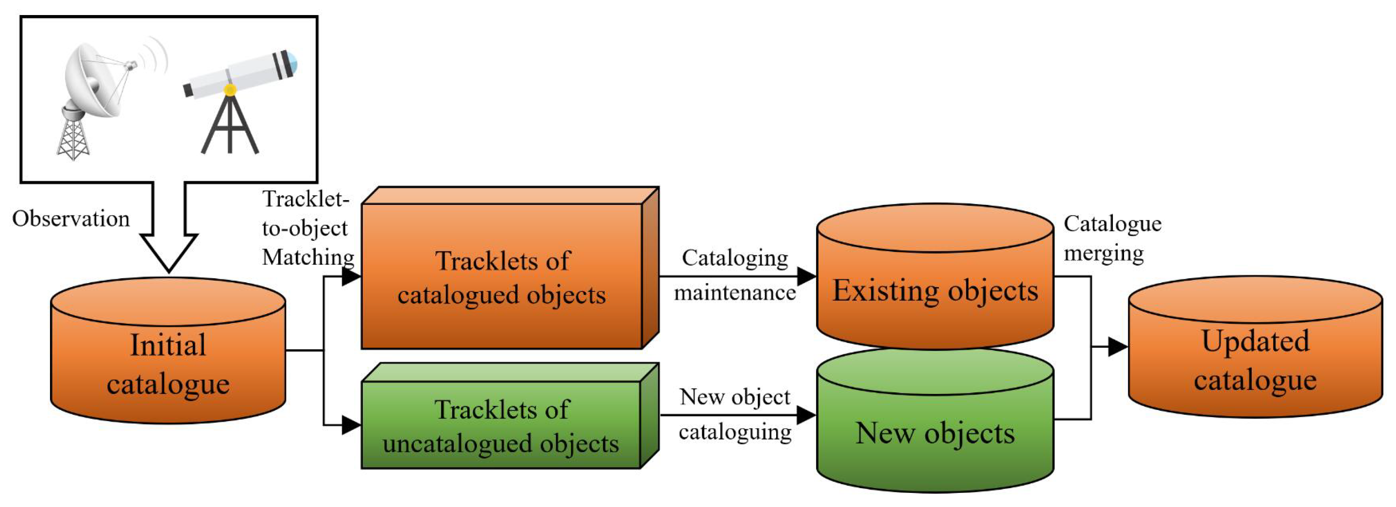
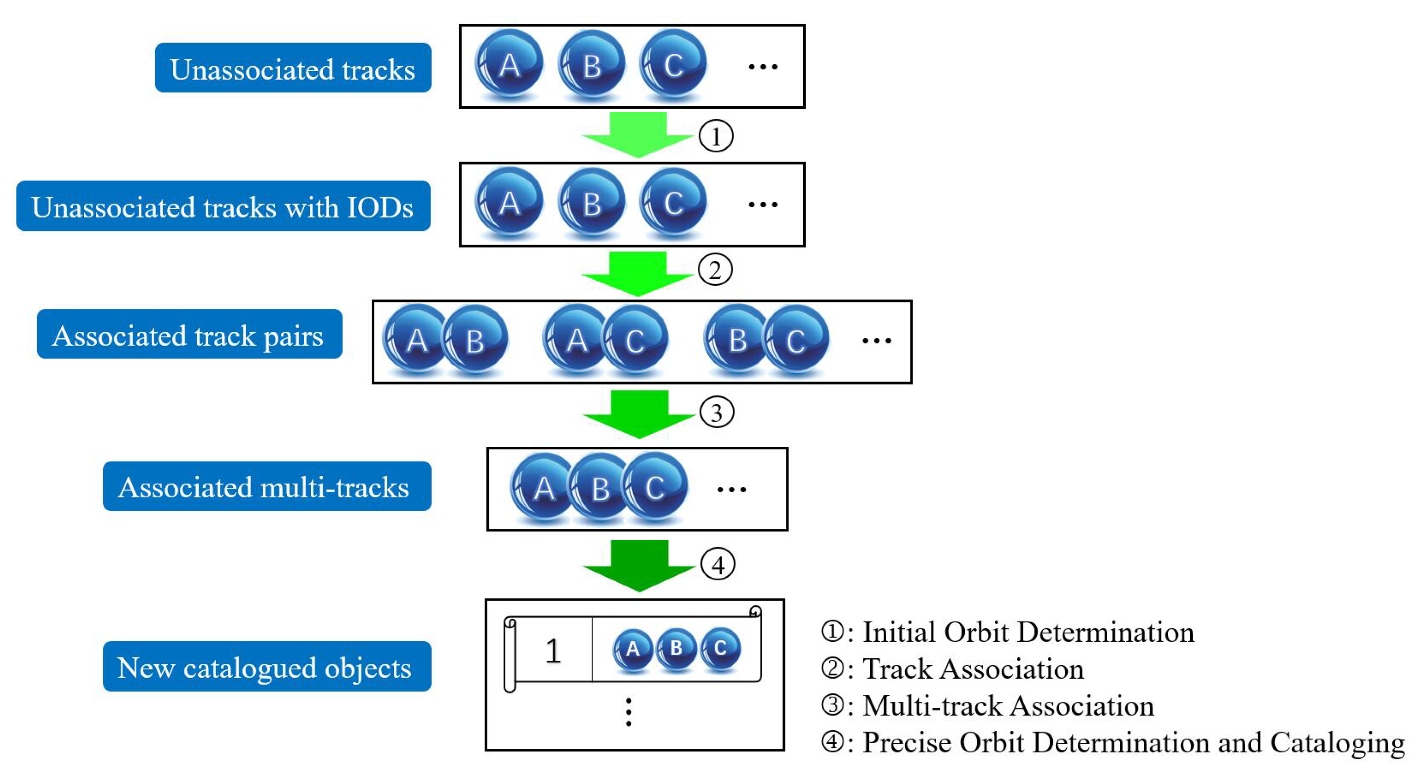
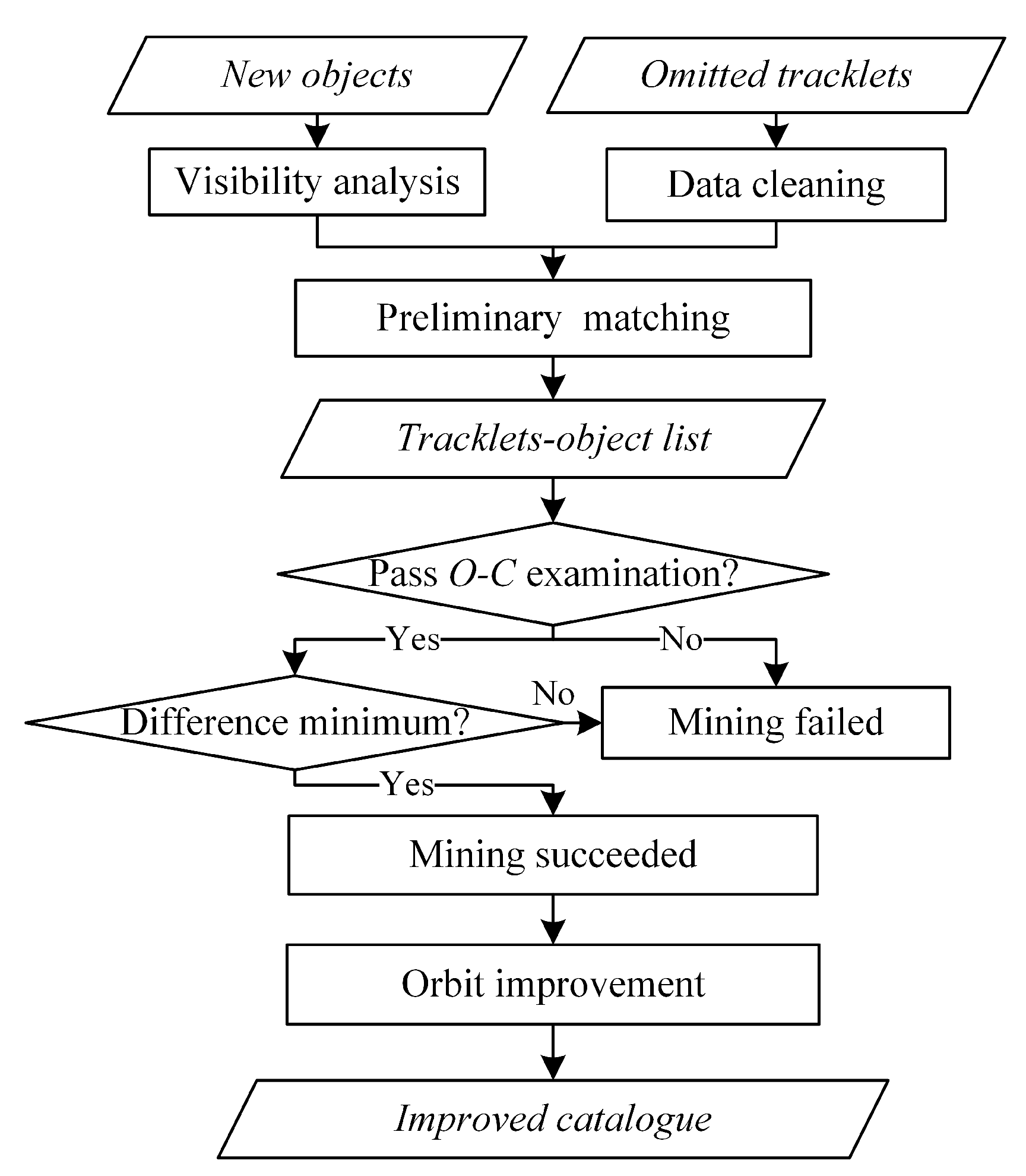
2.1. New Object Cataloguing Process

The main purpose of space object cataloguing is to establish and maintain a database of space object catalogues. The daily operation and maintenance of the catalogue mainly includes two aspects: maintaining existing objects and discovering new objects. The main process and key technologies for cataloguing new space objects are shown in Figure 2.
The process of cataloguing new space objects mainly involves four steps: IOD, track association, multi-track orbit determination, and precise orbit determination and cataloguing. Initially, IOD involves determining the orbital elements from observations of a single tracklet, with or without consideration of simple perturbation models [29,30]. The initial orbit derived from a single tracklet is characterized by unstable accuracy and therefore cannot be catalogued. As such, track association becomes necessary after the IOD. Track association refers to the association of tracklets, which can be classified as two-track association (also known as track association) and multi-track association. After multi-track association, the new objects are initially discovered. Precise orbital elements are then determined by combining multiple tracklets, using numerical orbit propagation method and sophisticated force models. Once precise orbital elements are determined, the new object can be catalogued and stored in the database. It is assigned a new ID and added to the catalogue database, along with other relevant information.

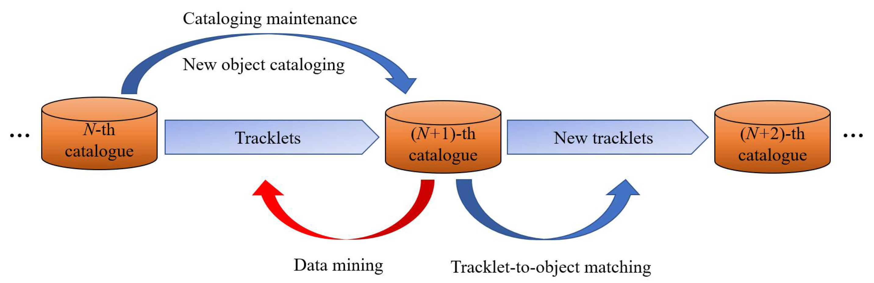
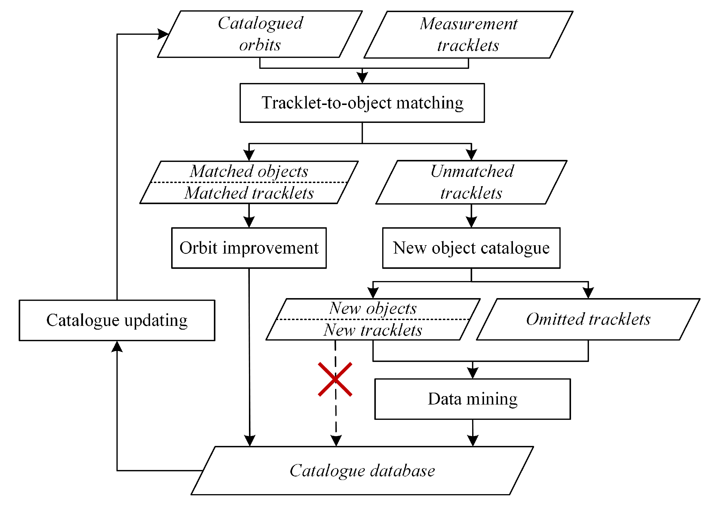
2.2. Data Mining in Space Object Catalogue

In the process of cataloguing new space objects, many tracklets are omitted after IOD and track association, which are called “omitted tracklets” in this paper. They are omitted for the following reasons:
(1) Short tracklet durations. In general, an optical/radar tracklet with an observation duration that is less than 1/100 of the orbital period is termed a Very Short Arc (VSA). The duration of a LEO VSA is typically under 60 s. A VSA contains little available orbital information, which could lead to the IOD failure. Even if the initial orbit is determined successfully, the initial orbital elements also contain large errors, which adversely affect the following track association. The large difference between the VSA’s initial orbit and others would make its association fail. An unrelated tracklet becomes useless and omitted.
(2) Long separation time. Considering that the success rate of track association decreases with the increase in the separation time between two tracklets, track association is generally performed within a certain time window to ensure time consumption and the success of association. Once the separation time between a tracklet and other tracklets of the object exceeds the window, the tracklet will also be omitted.
(3) Failed orbit determination. Observations of a tracklet may contain large gross errors or systematic errors. Gross errors can be eliminated by fitting or other methods, while systematic errors are hardly dealt with in general. With these gross and systematic errors unhandled, multi-track orbit determination is likely unable to converge, resulting in some tracklets being omitted.
Actually, these omitted tracklets still contain useful orbital information. A single VSA may not bring its value to play, but if mined, it can be used with other tracklets of the object to determine its accurate orbit. Even if it contains only a few data points, it can improve the phase distributions of tracklets in orbit, thus improving the orbit determination accuracy. In the case of limited data acquisition, insufficient use of these observations is a waste of resources. It is of great significance to improve data utilization and orbit determination accuracy to turn these omitted tracklets into treasure once again. To meet this demand, this paper proposes a method of mining omitted tracklets through tracklet-to-object matching.
The main idea of data mining in space object catalogue is shown in Figure 3. The precise orbits of the latest catalogued objects are applied to tracklet-to-object matching with omitted tracklets in IOD, track association, and orbit determination. Mined tracklets will be combined with catalogued tracklets for further orbit improvement.
Tracklet-to-object matching in the cataloguing process uses all catalogued objects in the catalogue database to match all newly observed tracklets. Compared to tracklet-to-object matching, data mining focuses more on backward mining on the timeline, that is, to rematch the omitted tracklets of the previous processing, with the latest catalogued objects.
The process of space object cataloguing with data mining is shown in Figure 4. After new objects are catalogued, data mining is conducted with unused tracklets instead of directly adding new objects to the catalogue database. Figure 5 shows the specific data mining process.
(1) Input omitted tracklets and perform data preprocessing. Second order least squares polynomial fitting is carried out to smooth observations for gross error elimination to make sure not to pick those outliers in subsequent matching. Record the observation time, distance, and other statistical information of the tracklets.
(2) Take the maximum observation time range of all omitted tracklets, and conduct orbit prediction for all new catalogued objects within this time range. If the cataloguing format is TLE, the SGP4/SDP4 analytical method is used. Based on the observation stations, calculate all theoretical observation tracklets of the new catalogued objects, and record tracklet time information.
(3) According to the starting and ending epochs, the actual observed tracklets are preliminarily matched with the computed tracklets, with the judgment basis as
T C 0 T O 0 < T O 1 T C 1
where T C 0 and T C 1 represent the starting and ending epochs of the computed tracklets; T O 0 and T O 1 represents the starting and ending epochs of the actual observed tracklets. After preliminary matching, an initial list of tracklet-to-object can be obtained.
(4) Select 5 evenly distributed data points from each tracklet in the initial list, as shown in Figure 6. Conduct orbit prediction with the catalogued orbit and compute the theoretical observations at the 5 points of each tracklet. The theoretical observations are calculated based on the predicted orbit and sensor parameters, and are used for comparison with actual observations in O C examination. In many cases, 5 uniformly distributed data points suffice to represent orbital information, avoiding unnecessary utilization of computational resources.
(5) Compute the difference between the theoretical observations and the actual observations. Taking the radar data as an example, the average errors of azimuth, elevation and range are calculated as follows:
Δ β = i = 1 n Δ β i × cos e l i / n Δ e l = i = 1 n Δ e l i / n Δ ρ = i = 1 n Δ ρ i / n
where n = 5 is the number of selected observation data points; β i , Δ e l i and Δ ρ i are the differences of azimuth, elevation, and range between observation and prediction at i-th epoch. The average angle error is computed as
Δ θ = ( Δ β ) 2 + ( Δ e l ) 2
The tracklet-to-object matching criteria are
Δ θ < θ k Δ ρ < ρ k
where θ k and ρ k are thresholds of angle error and range error. If Δ θ and Δ ρ are less than the thresholds at the same time, the matching between the object and the tracklet is judged successful. Otherwise, the matching fails. θ k and ρ k are taken according to different orbit types of objects. On the one hand, the SGP4/SDP4 analytical method used in the new object cataloguing has an average orbit determination accuracy of 5 km. On the other hand, the orbital propagation error caused by the long time interval of VSAs and the observation error of radars are also taken into consideration. 1 deg and 20 km would be reasonable for LEO radar tracklets [31]. If multiple objects are matched with a tracklet at the same time, the object with minimum average range error Δ ρ m i n will be chosen as the mined object.
Data mining in this paper is achieved by tracklet-to-object matching, which is to perform O C examination between observed tracklets and predicted tracklets. Compared to IOD and track association, matching is less affected by the duration and gross error of the tracklet, which will be demonstrated in the following section. Therefore, data mining can bypass IOD and track association, and maximize the mining and reuse of VSAs through tracklet-to-object matching.

3. Experimental Results

In this section, several experiments are conducted to validate the efficiency of the proposed data mining method. Firstly, the influence of VSAs on IOD, track association, and tracklet-to-object matching are assessed, respectively. Following that, new object cataloguing and data mining experiments are carried out based on thousands of radar tracklets.

3.1. Influences of VSAs on IOD, Track Association, and Tracklet-to-Object Matching

When cataloguing new objects, both IOD and track association involve calculating orbits based solely on observation data, without any prior orbital reference compared to a catalogued orbit. Therefore, the accuracy of IOD and the success rate of track association are inevitably affected by the quality of tracklets, including their duration and separation time. However, for tracklet-to-object matching, the catalogued orbits have already been determined by numerical methods, resulting in higher accuracy than single- or double-tracklet IOD results. Theoretically, the success rate of tracklet-to-object matching is less affected by tracklet quality. Consequently, tracklets that were omitted in IOD or track association due to their short duration, large observation errors, or long separation time can potentially be rediscovered through tracklet-to-object matching. This is the key idea of the data mining algorithm proposed in this paper.
In this section, we will first examine the impact of tracklet duration on IOD, track association, and tracklet-to-object matching, respectively.

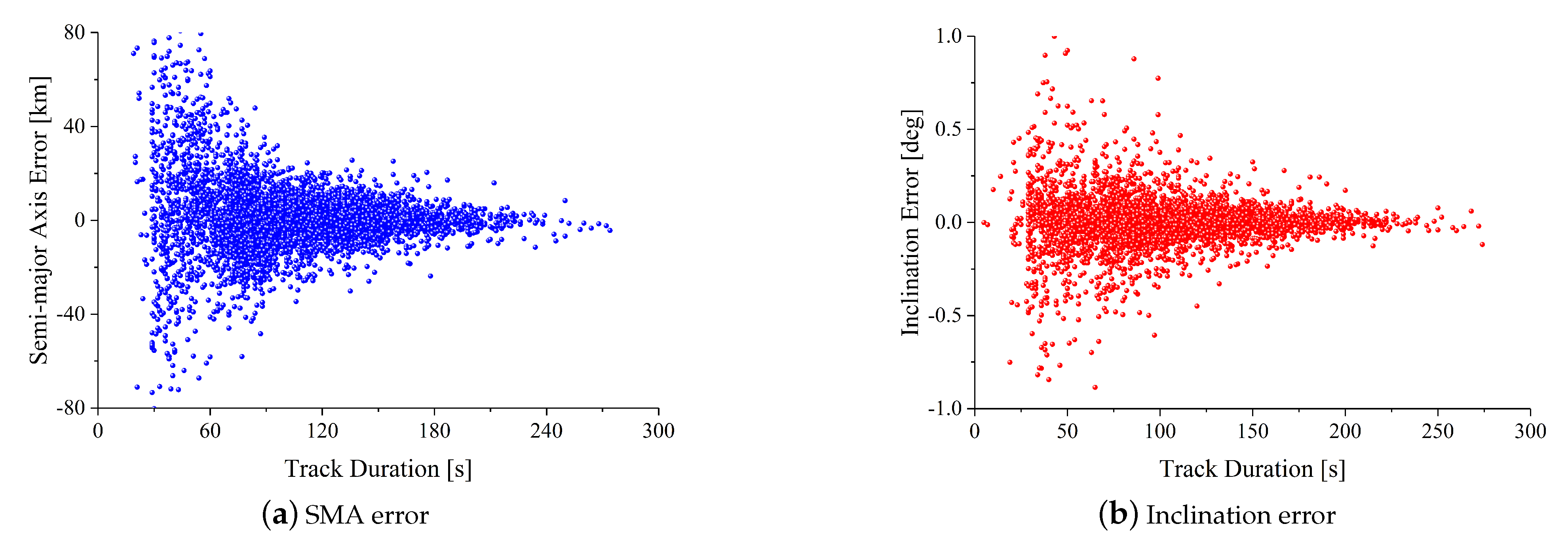
3.1.1. Initial Orbit Determination

The initial orbits of LEO objects are determined using a large amount of radar tracking data. These objects have altitudes between 400 km and 2000 km. The radar station is located at 115°E longitude and 30°N latitude. Measurement errors are 50 m (1− σ ) for ranges and 100”(1− σ ) for azimuth and elevation angles. The tracking observation lasted 10 days from 10 August 2021 to 19 August 2021, resulting in 5029 orbit measurement tracklets. Gooding’s method is used to determine the initial orbits [32].
Figure 7 shows the semi-major axis (SMA) and inclination errors of the initial orbit determined from radar tracklets with different durations. It shows that both the SMA error and the inclination error of the initial orbit decrease with the increase in track durations. When the track duration is less than 100 s, the SMA error RMS is 21.6 km and the inclination error is 625”. When the track duration is longer than 100 s, the SMA error RMS drops to 7.1 km and the inclination error RMS drops to 237”.
The above results indicate that the durations of tracklets directly affect the orbit accuracy of IOD. The shorter the tracklet is, the larger the error would be. Initial orbits of VSAs have low precisions and reliabilities, which would bring adverse effects to the subsequent track association based on initial orbital elements.

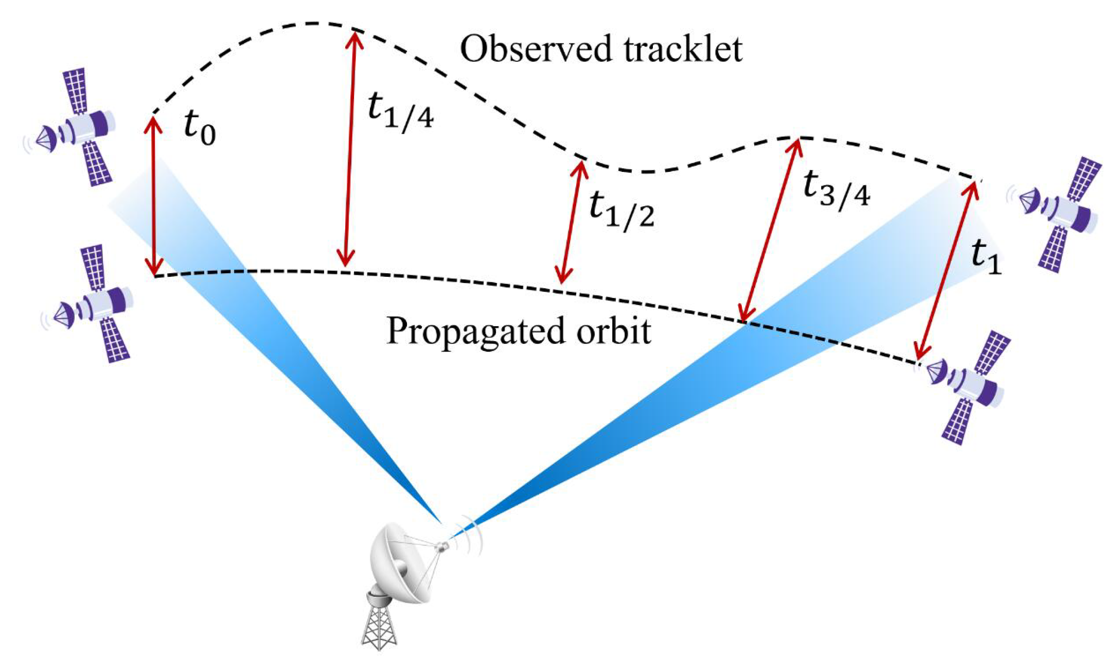
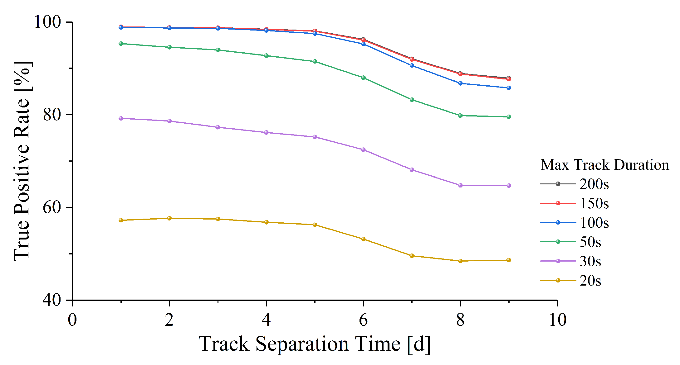
3.1.2. Track Association

This section aims to evaluate the impact of tracklet duration and separation time on the success rate of the two-track association algorithm. Following the initial orbit results outlined in the previous section, we associated two tracklets with varying durations (20–200 s) and separation times (1–9 days), and recorded the corresponding changes in the True Positive (TP) rate. The method utilized to associate two tracklets is based on correction for perturbation, which can be referred to our previous work [17].
Figure 8 illustrates the effect of different tracklet durations and separation times on the TP rate of two-track association. Generally, the TP rate decreases as the tracklet separation time increases. However, when the maximum duration is limited to 200 s, the TP rate remains consistently high. In addition, when the separation time between two tracklets is within 5 days, the TP rate remains stable above 98.0%. After 5 days, the TP rate began to decline gradually and reached 87.8% by day 9.
When the maximum tracklet duration is limited to 150 s and 100 s, respectively, the TP rate does not change significantly within five days of separation, but decreases to 87.6% and 85.8%, respectively, on day 9. However, if the maximum duration is limited to 50 s, the TP rate drops more significantly, from 95.3% to 91.5% in five days and to 79.5% on the ninth day.
It is noteworthy that tracklet durations greatly influence the effect of track association, especially when the observed duration is within 30 s. The shorter the tracklet durations, the lower the TP rate, which subsequently leads to the omission of VSAs. In fact, when the maximum duration is 20 s, the TP rate ranges only from 48.6% to 57.6%.

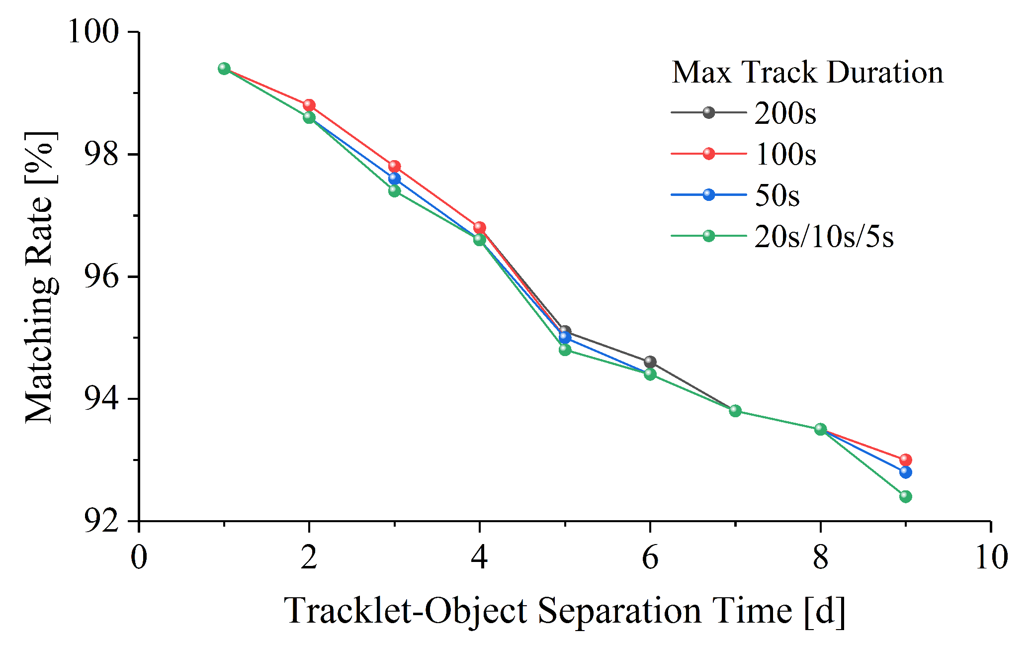
3.1.3. Tracklet-to-Object Matching

Tao et al. proposed a tracklet-to-object matching method based on TLE filtering, which involves initial screening based on tracklet IOD results [33]. In contrast, the matching approach proposed in Section 2.2 circumvents the IOD step and directly executes O C examination utilizing theoretical observations.
In contrast to IOD and track association, the matching rate for tracklet-to-object is minimally affected by tracklet durations and separation times. The data shown in Figure 9 confirms this finding, indicating that the matching rate correlates solely with the separation time between tracklet and object. With maximum durations of 200 s and 5 s, matching rates vary similarly, ranging from 99.4% to 93.0% and 92.4%, respectively. The longer the separation time and orbital propagation time are, the lower the predicted orbital accuracy and the matching rate will be.
The tracklet-to-object matching method proposed in this paper uses theoretical observations for direct O C examination and does not rely on the initial orbit determination results. Thus, it is based on catalogued orbits mainly referring to the TLEs, and nearly unaffected by tracklet duration. In contrast, both IOD and track association are strongly influenced and limited by tracklet duration. As the tracklet duration decreases, the accuracy of IOD and the TP rate of track association also decrease. This comparison demonstrates that the tracklet-to-object matching technique is more robust and reliable than IOD and track association for space object catalogue when catalogued orbits are available.

3.2. New Space Object Catalogue and Data Mining

The aforementioned experiments have concluded that tracklet-to-object matching is minimally affected by track duration and separation time as compared to IOD and track association. This verifies the superiority of the data mining approach proposed in this paper. Furthermore, new object cataloguing and data mining experiments are conducted based on thousands of radar tracklets to evaluate the method’s feasibility and effectiveness in realistic space object cataloguing.

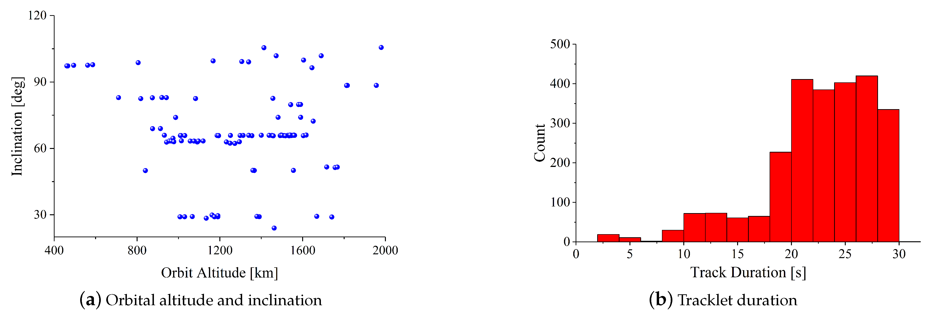
3.2.1. Data Preparation

A total of 2515 radar tracklets of 104 LEO objects are observed from 10 August 2021 to 14 August 2021. The distribution of the objects’ orbital elements is shown in Figure 10a. The orbital altitudes are evenly distributed at 400–2000 km and the orbital inclinations range from 24° to 105°. The duration distribution of the tracklets is shown in Figure 10b. The duration of most tracklets is 20–30 s, of which 9.3% are within 15 s, and the shortest duration is only 2 s.
For verification purposes, the 104 objects were treated as completely unknown new objects, without any prior information as a reference during the experiment. Cataloguing starts from 0. After completing the experiment, known object ID information is only used to verify whether these new objects are correctly catalogued. These tracklets are all used for cataloguing new objects, and further data mining is carried out on the basis of new objects. The data mining algorithm is validated and the performance is verified by comparing data utilization and orbit accuracy before and after data mining, respectively.

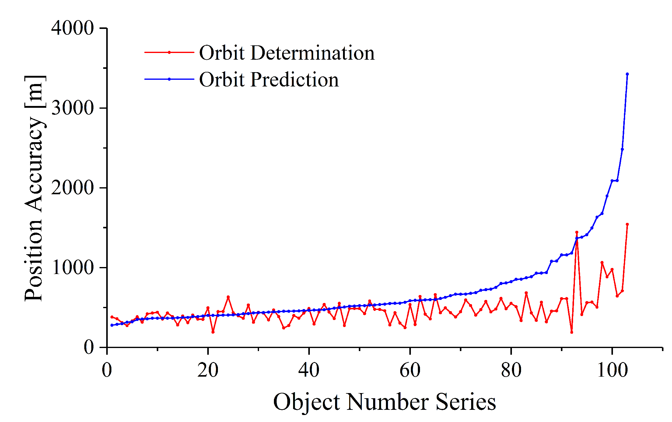
3.2.2. New Object Cataloguing
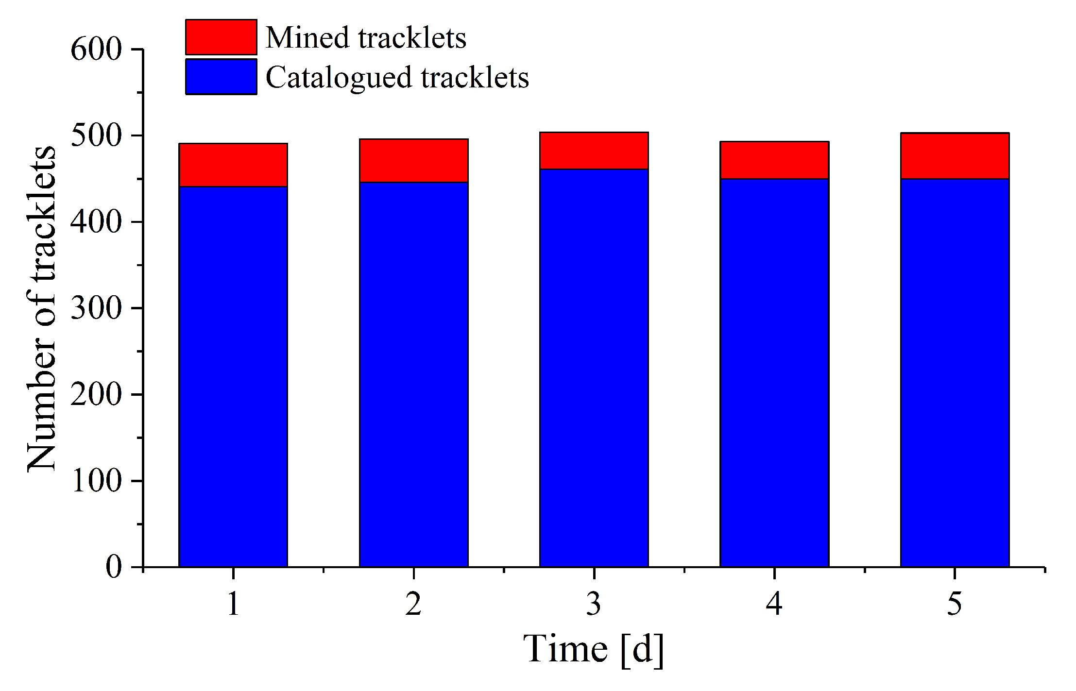
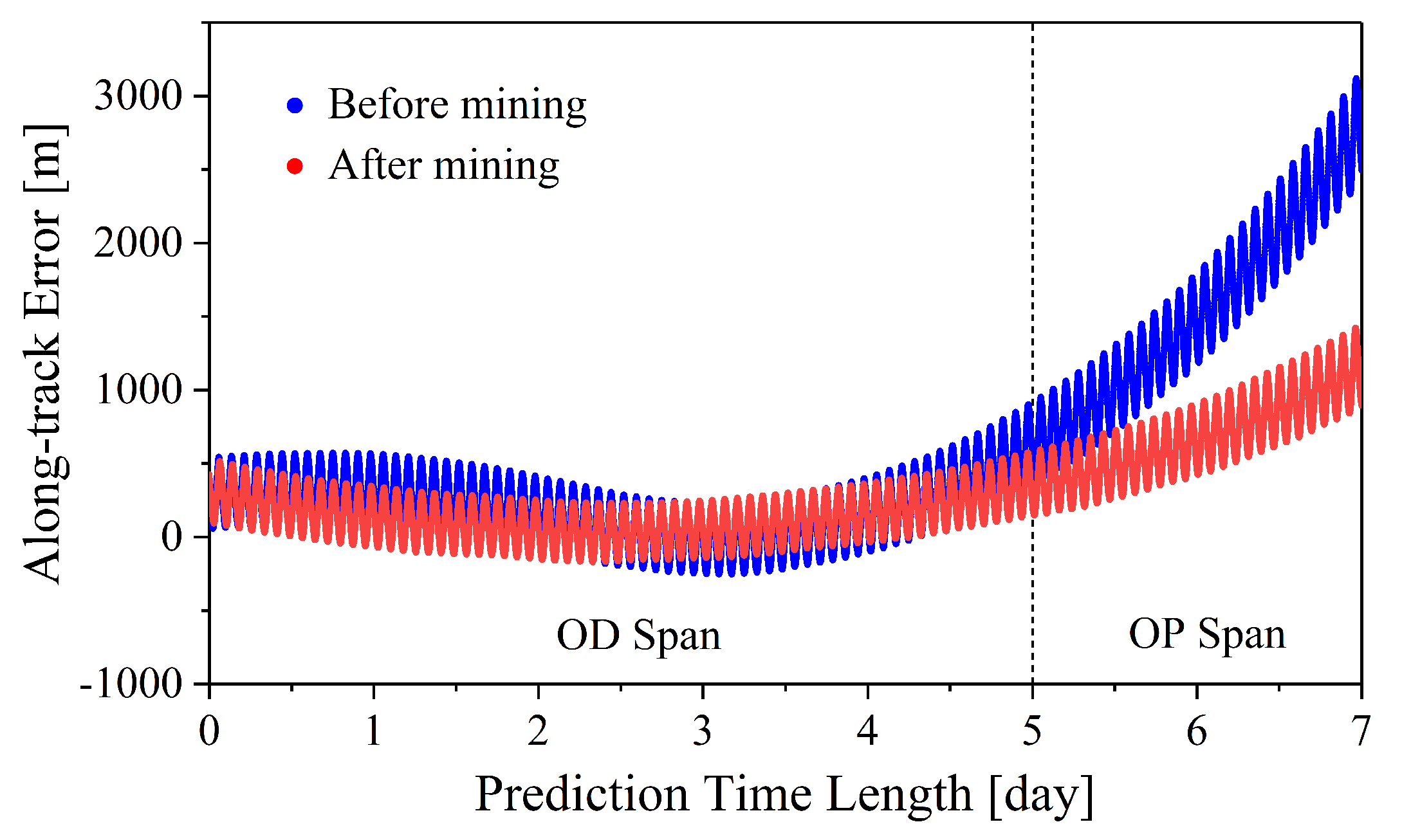
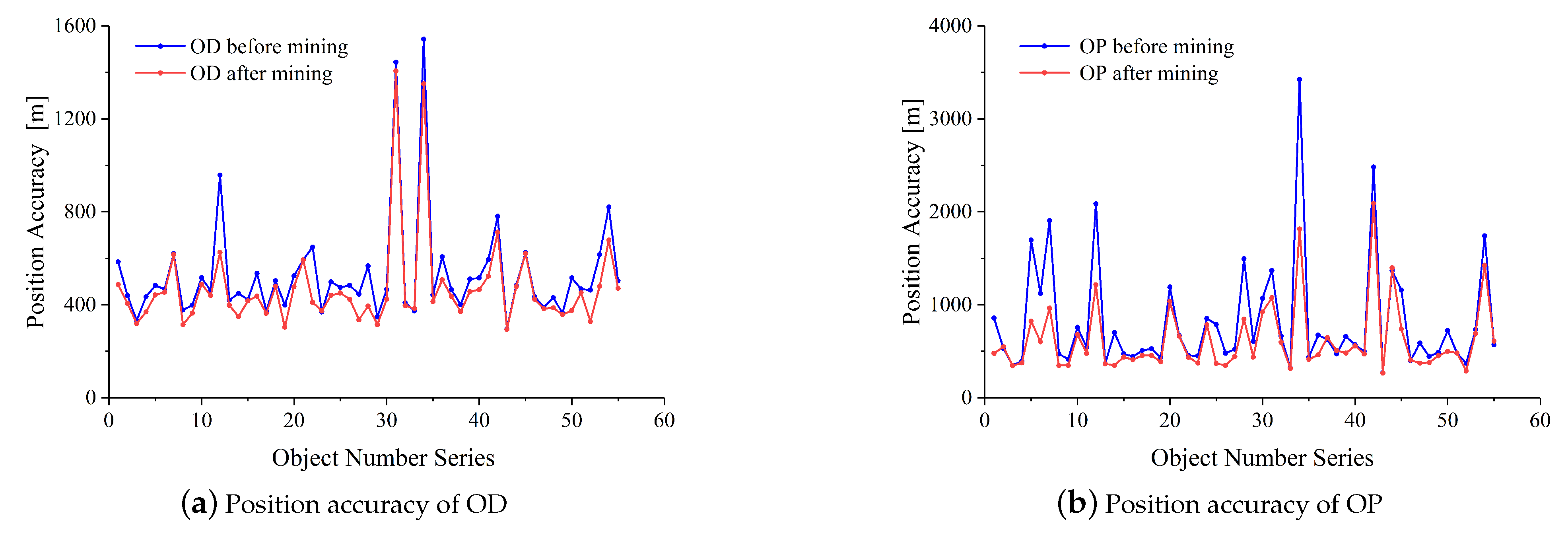
Based on the 2515 radar tracklets, a new object cataloguing experiment is carried out, which includes IOD, two/multi-track association, precise orbit determination and cataloguing. The cataloguing results are shown in Table 1. In the cataloguing of new objects, 103 objects are successfully catalogued, which makes the cataloguing rate of objects reach 99.04%, while the utilization rate of tracklets is only 89.38%, with 233 VSAs omitted.
Figure 11 shows the OD/OP accuracy of the 103 new catalogued objects, with abscissa sorted in ascending order of OP accuracy. It is noted that about 97.09% of catalogued objects have an OD accuracy of less than 1 km, and 96.12% of catalogued objects have a 2-day OP accuracy of less than 2 km. The maximum prediction error is 3.4 km due to the omission of two VSAs and the limited geometric constraint.

3.2.3. Data Mining

After cataloguing the 103 new objects, data mining is carried out on unused tracklets based on catalogued orbits. Data mining results are shown in Figure 12 and Table 2. It can be seen that after mining, the number of catalogued objects remains 103, but the daily data utilization rate increases by 8–10%, and the total data utilization rate in all five days increases from 89.38% to 98.89%.
Figure 13 presents the along-track prediction error of a catalogued object (NORAD ID: 14483) before and after mining. The data mining process successfully extracted two short tracklets lasting 8 s and 20 s, respectively. These two new tracks are then used in the orbit determination together with the already matched tracklets. Since the orbit geometric constraint has been strengthened, an accuracy improvement of the orbit determination and prediction can be expected, as presented in Figure 13. The new two tracks contribute to the orbit determination and prediction accuracy, in which the along-track orbit prediction error reduces from 3.1 km to 1.4 km.
Figure 14 shows changes in the orbit determination accuracy and 2-day orbit prediction accuracy for 55 successfully mined objects. The majority of mined objects show significant improvements in orbital accuracy, with only a few showing slight deviations. The orbit determination accuracy is improved by 11.1% from an average of 529 m to 470 m, while the 2-day prediction accuracy is improved by 23.6% from an average of 813 m to 621 m. In addition, the maximum prediction error decreased from 3.4 km to 1.8 km.

4. Conclusions

In the process of cataloguing new objects, the accuracy of IOD and the true positive rate of track association can be adversely affected by tracklet duration. Due to the lack of prior precise orbital information, plenty of tracklets are omitted and new space objects are lost. To overcome this challenge, this paper proposes a data mining method for cataloguing new space objects. The method aims to convert unused tracklets into valuable data through tracklet-to-object matching based on the orbit elements of newly catalogued space objects and the omitted tracklets. The experiment indicates that this proposed method can effectively improve the data utilization and the accuracy of orbit determination and prediction. With the proposed method, over a five-day period, data utilization improved by 9.5%, while accuracy in the orbit determination and prediction improved by 11.1% and 23.6%, respectively. Such orbital accuracy improvement of catalogued new objects plays important role in the high-precision space applications, like the space collision warning.
This paper’s distinctiveness lies in successfully conducting data mining for new space object cataloguing through tracklet-to-object matching, thereby improving the data utilization and cataloguing accuracy. The method’s performance is solely influenced by the accuracy of the catalogued orbit and propagation time, remaining unaffected by the IOD accuracy of VSAs. Therefore, in principle, this method is entirely suitable for optical and infrared sensor data. Considering the optical sensors’ improved accuracy in angle measurement but lack of range information, the mining threshold should be adjusted according to different sensor types and measurement accuracy. Further research and discussions are justified.

Author Contributions

Resources and writing—original draft, L.L.; writing—review and editing, B.L.; conceptualization, J.S.; software, S.X.; formal analysis, X.L. All authors have read and agreed to the published version of the manuscript.

Funding

This research was funded by the National Natural Science Foundation of China [Grant No. 12103035], the Special Fund of Hubei Luojia Laboratory [Grant No. 230600003], and the Fundamental Research Funds for the Central Universities [Grant No. 2042023gf0007].

Data Availability Statement

Restrictions apply to the availability of these data. Data were obtained from [Space-Track.org] and are available [https://www.space-track.org (accessed on 1 July 2023)] with the permission of [Space-Track.org].

Acknowledgments

The authors are grateful to anonymous reviewers whose constructive and valuable comments greatly helped us to improve the paper.

Conflicts of Interest

The authors declare no conflict of interest.

Abbreviations

The following abbreviations are used in this manuscript:
GEOGeosynchronous Earth Orbit
IODInitial Orbit Determination
LEOLow Earth Orbit
MEOMedium Earth Orbit
NORADNorth American Aerospace Defense Command
ODOrbit Determination
OPOrbit Prediction
RSOResident Space Object
RMSRoot Mean Square
SMASemi-major Axis
SDP4Simplified Deep-Space Perturbation 4
SGP4Simplified General Perturbation 4
TPTrue Positive
TLETwo-line Element
VSAVery Short Arc

References

  1. Sun, C.; Sun, Y.; Yu, X.; Fang, Q. Rapid Detection and Orbital Parameters’ Determination for Fast-Approaching Non-Cooperative Target to the Space Station Based on Fly-around Nano-Satellite. Remote Sens. 2023, 15, 1213. [Google Scholar] [CrossRef]
  2. Herzog, J. Cataloguing of Objects on High and Intermediate Altitude Orbits. Ph.D. Thesis, Universität Bern, Basel, Switzerland, 2013. [Google Scholar]
  3. Liu, W. Based on the Application and Analysis of the Space Coding Database. Ph.D. Thesis, Xiangtan University, Xiangtan, China, 2013. [Google Scholar]
  4. Boikov, V.F.; Makhonin, G.; Testov, A.; Khutorovsky, Z.N.; Shogin, A. Prediction procedures used in satellite catalog maintenance. J. Guid. Control. Dyn. 2009, 32, 1179–1199. [Google Scholar] [CrossRef]
  5. Li, B.; Sang, J.; Liu, H. Accurate propagation of debris orbit error via dynamic calibration and its cataloguing. Adv. Space Res. 2019, 63, 2422–2435. [Google Scholar] [CrossRef]
  6. Abdelaziz, A.; Ibrahim, M.; Liang, Z.; Dong, X.; Tealib, S. Orbit Predictions for Space Object Tracked by Ground-Based Optical and SLR Stations. Remote Sens. 2022, 14, 4493. [Google Scholar] [CrossRef]
  7. Setty, S.J.; Cefola, P.J.; Montenbruck, O.; Fiedler, H. Application of semi-analytical satellite theory orbit propagator to orbit determination for space object catalog maintenance. Adv. Space Res. 2016, 57, 2218–2233. [Google Scholar] [CrossRef]
  8. Utzmann, J.; Wagner, A.; Silha, J.; Schildknecht, T.; Willemsen, P.; Teston, F.; Flohrer, T. A system design for space-based space surveillance. In Proceedings of the Small Satellites Systems & Services Symposium, Porto Petro, Majorca, Spain, 26–30 May 2014; pp. 26–30. [Google Scholar]
  9. Jianli, D. Researches on Space-Based Surveillance System for Cataloging Space Debris. Ph.D. Thesis, Wuhan University, Wuhan, China, 2018. [Google Scholar]
  10. Du, J.; Lei, X.; Sang, J. A space surveillance satellite for cataloging high-altitude small debris. Acta Astronaut. 2019, 157, 268–275. [Google Scholar] [CrossRef]
  11. Peng, H.; Bai, X. Machine learning approach to improve satellite orbit prediction accuracy using publicly available data. J. Astronaut. Sci. 2020, 67, 762–793. [Google Scholar] [CrossRef]
  12. Zhang, Y.; Li, B.; Liu, H.; Sang, J. An analysis of close approaches and probability of collisions between LEO resident space objects and mega constellations. Geo-Spat. Inf. Sci. 2022, 25, 104–120. [Google Scholar] [CrossRef]
  13. Hussain, K.F.; Thangavel, K.; Gardi, A.; Sabatini, R. Passive Electro-Optical Tracking of Resident Space Objects for Distributed Satellite Systems Autonomous Navigation. Remote Sens. 2023, 15, 1714. [Google Scholar] [CrossRef]
  14. Lei, X.; Wang, K.; Zhang, P.; Pan, T.; Li, H.; Sang, J.; He, D. A geometrical approach to association of space-based very short-arc LEO tracks. Adv. Space Res. 2018, 62, 542–553. [Google Scholar] [CrossRef]
  15. Pastor, A.; Escobar, D.; Sanjurjo, M.; Águeda, A. Data processing methods for catalogue build-up and maintenance. In Proceedings of the 1st NEO and Debris Detection Conference, Darmstadt, Germany, 22–24 January 2019; Volume 1. [Google Scholar]
  16. Reihs, B.; Vananti, A.; Schildknecht, T. A method for perturbed initial orbit determination and correlation of radar measurements. Adv. Space Res. 2020, 66, 426–443. [Google Scholar] [CrossRef]
  17. Liu, L.; Li, B.; Chen, J.Y.; Lei, X.X.; Zhao, G.Y.; Sang, J.Z. Applying Lambert problem to association of radar-measured orbit tracks of space objects. Res. Astron. Astrophys. 2021, 21, 301. [Google Scholar] [CrossRef]
  18. Zhao, G.; Liu, L.; Li, B.; Li, Z.; Sang, J. An orbit determination approach to associating optical tracklets of space objects. Acta Astronaut. 2022, 200, 506–523. [Google Scholar] [CrossRef]
  19. Hill, K.; Sabol, C.; Alfriend, K.T. Comparison of covariance based track association approaches using simulated radar data. J. Astronaut. Sci. 2012, 59, 281–300. [Google Scholar] [CrossRef]
  20. Pirovano, L.; Principe, G.; Armellin, R. Data association and uncertainty pruning for tracks determined on short arcs. Celest. Mech. Dyn. Astron. 2020, 132, 1–23. [Google Scholar] [CrossRef]
  21. Milani, A.; Tommei, G.; Farnocchia, D.; Rossi, A.; Schildknecht, T.; Jehn, R. Correlation and orbit determination of space objects based on sparse optical data. Mon. Not. R. Astron. Soc. 2011, 417, 2094–2103. [Google Scholar] [CrossRef]
  22. McMahon, J.W.; Scheeres, D.J. Improving space object catalog maintenance through advances in solar radiation pressure modeling. J. Guid. Control. Dyn. 2015, 38, 1366–1381. [Google Scholar] [CrossRef]
  23. Hobson, T.; Clarkson, I.; Bessell, T.; Rutten, M.; Gordon, N.; Moretti, N.; Morreale, B. Catalogue creation for space situational awareness with optical sensors. In Proceedings of the Advanced Maui Optical and Space Surveillance Technologies Conference, Maui, HI, USA, 20–23 September 2016; p. 27. [Google Scholar]
  24. Setty, S. Orbit Uncertainty Propagation for Space Object Catalogue Maintenance. Ph.D. Thesis, Universität der Bundeswehr München, Neubiberg, Germany, 2020. [Google Scholar]
  25. Vallado, D.A. Fundamentals of Astrodynamics and Applications; Springer Science & Business Media: Berlin/Heidelberg, Germany, 2001; Volume 12. [Google Scholar]
  26. Cataldo, D.; Gentile, L.; Ghio, S.; Giusti, E.; Tomei, S.; Martorella, M. Multibistatic Radar for Space Surveillance and Tracking. IEEE Aerosp. Electron. Syst. Mag. 2020, 35, 14–30. [Google Scholar] [CrossRef]
  27. Yunpeng, H.; Kebo, L.; Yan’gang, L.; Lei, C. Review on strategies of space-based optical space situational awareness. J. Syst. Eng. Electron. 2021, 32, 1152–1166. [Google Scholar] [CrossRef]
  28. Muntoni, G.; Montisci, G.; Pisanu, T.; Andronico, P.; Valente, G. Crowded space: A review on radar measurements for space debris monitoring and tracking. Appl. Sci. 2021, 11, 1364. [Google Scholar] [CrossRef]
  29. Escobal, P. Methods of Orbit Determination; Krieger Publishing Company: Malabar, FL, USA, 1970. [Google Scholar]
  30. Maruskin, J.M.; Scheeres, D.J.; Alfriend, K.T. Correlation of optical observations of objects in earth orbit. J. Guid. Control. Dyn. 2009, 32, 194–209. [Google Scholar] [CrossRef]
  31. Li, B.; Liu, L.; Sang, J.Z. Tracklet-to-object Matching for Climbing Starlink Satellites through Recursive Orbit Determination and Prediction. Res. Astron. Astrophys. 2022, 22, 115010. [Google Scholar] [CrossRef]
  32. Gooding, R.H. A procedure for the solution of Lambert’s orbital boundary-value problem. Celest. Mech. Dyn. Astron. 1990, 48, 145–165. [Google Scholar] [CrossRef]
  33. Tao, X.; Li, Z.; Xu, C.; Huo, Y.; Zhang, Y. Track-to-object association algorithm based on TLE filtering. Adv. Space Res. 2021, 67, 2304–2318. [Google Scholar] [CrossRef]
Figure 1. Cataloguing maintenance and new object cataloguing.
Remotesensing 15 04848 g001
Figure 2. Main process of cataloguing new space objects.
Remotesensing 15 04848 g002
Figure 3. Data mining and tracklet-to-object matching.
Remotesensing 15 04848 g003
Figure 4. Data mining in space object catalogue.
Remotesensing 15 04848 g004
Figure 5. Data mining process.
Remotesensing 15 04848 g005
Figure 6. Point selection of tracklets.
Remotesensing 15 04848 g006
Figure 7. Errors of initial orbit elements.
Remotesensing 15 04848 g007
Figure 8. TP rate of two-track association with different tracklet durations.
Remotesensing 15 04848 g008
Figure 9. Tracklet-to-object matching rate with max different durations.
Remotesensing 15 04848 g009
Figure 10. Distribution of orbital elements and duration of tracklets for experimental objects.
Remotesensing 15 04848 g010
Figure 11. Orbit determination and prediction accuracy of 103 catalogued objects (abscissa sorted in ascending order of OP accuracy).
Remotesensing 15 04848 g011
Figure 12. Number of catalogued tracklets and mined tracklets.
Remotesensing 15 04848 g012
Figure 13. Along-track prediction error of the object (Norad ID: 14483) before and after data mining.
Remotesensing 15 04848 g013
Figure 14. Orbit determination and prediction accuracy of 55 mined objects.
Remotesensing 15 04848 g014
Table 1. New object cataloguing results.
Catalogued ObjectsCataloguing RateCatalogued TrackletsTracklet Utilization
10399.04%224889.38%
Table 2. Data utilization rate before and after data mining.
Time [day]Utilization after Cataloguing [%]Utilization after Mining [%]Utilization Improved [%]
188.9198.9910.08
288.6798.619.94
390.5799.028.45
490.3699.008.63
588.4198.8210.41
Disclaimer/Publisher’s Note: The statements, opinions and data contained in all publications are solely those of the individual author(s) and contributor(s) and not of MDPI and/or the editor(s). MDPI and/or the editor(s) disclaim responsibility for any injury to people or property resulting from any ideas, methods, instructions or products referred to in the content.

