Review

Advancement in the Application of Geospatial Technology in Archaeology and Cultural Heritage in South Africa: A Scientometric Review

by
Charles Matyukira
and
Paidamwoyo Mhangara
*
School of Geography, Archaeology and Environmental Studies, University of the Witwatersrand, Johannesburg 2050, South Africa
*
Author to whom correspondence should be addressed.
Remote Sens. 2023, 15(19), 4781; https://doi.org/10.3390/rs15194781
Submission received: 29 August 2023 / Revised: 18 September 2023 / Accepted: 27 September 2023 / Published: 30 September 2023
(This article belongs to the Special Issue 3D Modeling and GIS for Archaeology and Cultural Heritage)

Abstract

:
Geospatial technologies have become an essential component of archaeological research, aiding in the identification, mapping, and analysis of archaeological sites. Several journals have published existing narratives on the development and impact of geospatial technologies in the study of archaeology and cultural heritage. However, this has not been supported by a systematic review of articles and papers, where meticulously collected evidence is methodically analysed. This article systematically reviews the trends in the use of geospatial technologies in archaeology and cultural heritage through the search for keywords or terms associated with geospatial technologies used in the two fields on the Scopus database from 1990 to 2022. Bibliometric analysis using the Scopus Analyze tool and analysis of bibliometric networks using VOSviewer visualisations reveals how modern archaeological studies are now a significant discipline of spatial sciences and how the discipline enjoys the tools of geomatic engineering for establishing temporal and spatial controls on the material being studied and observing patterns in the archaeological records. The key concepts or themes or distinct knowledge domains that shape research in the use of geospatial technologies in archaeology and cultural heritage, according to the Scopus database (1990–2022), are cultural heritage, archaeology, geographic information systems, remote sensing, virtual reality, and spatial analysis. Augmented reality, 3D scanning, 3D modelling, 3D reconstruction, lidar, digital elevation modelling, artificial intelligence, spatiotemporal analysis, ground penetrating radar, optical radar, aerial photography, and unmanned aerial vehicles (UAVs) are some of the geospatial technology tools and research themes that are less explored or less interconnected concepts that have potential gaps in research or underexplored topics that might be worth investigating in archaeology and cultural heritage.

1. Introduction

The application of geospatial technology in a broad spectrum of fields is gaining momentum worldwide. The widespread application of geospatial technology has resulted in a multiplicity of definitions owing to the distinct perspectives of the stakeholders. Some denote this application as a science, while others consider geospatial technology a group of tools used in various professional fields. Geospatial technology is also recognised as a profession with codes of ethics and specific competence standards [1]. As a profession, geospatial technology, also referred to as geomatics, is a growing multidisciplinary academic field with diverse applications encompassing land surveying, remote sensing, mapping, geographic information systems (GIS), geodesy, and global navigation systems [2]. This multidisciplinary academic field constitutes a geospatial industry defined by the United States Department of Labour as “an information technology field of practice that acquires, manages, interprets, integrates, displays, analyses, or otherwise uses data focusing on the context” [3]. From this definition, Ref. [3] deduced that geospatial technologies should be classified as GIS, global navigation satellite systems (GNSS), photogrammetry, remote sensing, cartography, surveying, and other related fields. Aina [2] concurred with Klinkenberg [3] on the definitions. She added devices such as cellular phones, RFID (radio frequency identification) tags and surveillance cameras with embedded technologies that use locational information to the list of geospatial technologies. The fields in which geospatial technologies have been implemented are wide-ranging, including facilities management, precision farming, urban planning, business geographics, security and intelligence, telecommunication, automated mapping, and civil engineering. Archaeology is a further field where such technology has been applied [2]. There is an established deep link between geospatial technologies and information communication systems, which has benefitted geomatics fields such as GIS [2]. The above discussion elucidates what this literature review refers to as geospatial technologies.
As early as the 18th century, archaeologists had grasped the importance of spatial data accompanying archaeological recordings, ranging from relative locations with varying scales to data depicting individual artefacts with excavation contexts [4]. Over the years, the deployment of geospatial technology in archaeology has been used to expound on different spatial phenomena. Such phenomena include seasonal hunter–gatherer camps within a landscape, the hierarchy of settlements within a region, the location of artisanal mines in an area, and many others that exploit spatial links, patterns, and relationships [4]. According to Aina [2], Wheatley and Gillings [4], the study of spatial archaeological data has grown from descriptive (tabulated and plotted on simple flat maps) to explanatory (explanation of spatial patterns and relations). Wheatley and Gillings [4] further attributed this development to emerging robust geospatial technologies capable of handling high volumes of spatial data with high resolutions and processing speeds.
According to Nsanziyera and three other authors [5], the tremendous growth in remotely sensed spatial data has created new horizons and possibilities for archaeological research, such as creating predictive models that are becoming standard tools for investigation in GIS mapping. Further, these advancements in geospatial technologies have created new territories for research in archaeology and many documents in journals of different rankings. Although several journals have published existing narratives on the development and impact of geospatial technologies in the study of archaeology, as noted in this review and others, this has not been supported by a systematic review of articles and papers [6]. In a systematic review, evidence is assembled, identified, and critically analysed through systematic procedure so that readers are constantly updated about current literature on the subject [7]. According to Linnenluecke and two other authors [6], the world is witnessing an exponential growth of poor-quality scholarly articles, often in open-access formats in predatory journals and good scholarly articles in ranked journals. However, according to Brembs [8], the reliability of even exceptionally high-ranking journals could be better, but these journals are currently the only source of credible information on geospatial technologies. This review aims to establish the trend in using and applying geospatial technologies in archaeology globally and in South Africa using the Scopus database. Scopus is an extensive database that provides fully referenced scholarly documents in social sciences, arts, humanities, science, technology, and medicine [9]. The following section gives a framework of the goals and objectives of using geospatial technologies in archaeology.

1.1. Geospatial Technology in Archaeology

Before reviewing the goals and objectives of geospatial technology in archaeology, it is necessary to first look at the field of archaeology itself. The latter has undergone many changes over the past century. Each change attracts a new purpose or modification of the existing ones (Trigger, 1989, pp. 370–411, as cited in [10]). Establishing temporal and spatial controls on the material being studied and observing patterns in the archaeological records forms the backbone of modern archaeology; however, some aspects have been retained from the older versions of archaeology, such as in archaeological studies that are defined as cultural/historical, new, and or postprocessual [10]. Historically, the usage of geospatial technologies in archaeology aimed to produce archaeological maps (primarily hand-drawn) meant to record/document site progress and archaeological investigations [11,12]. For instance, the objective of traditional sketch maps was to record the in situ context or geometrical descriptions of uncovered material evidence [10,13,14,15,16]. With advanced geospatial technologies, modern complex maps aim to visualise geometric structures, taphonomic associations and linkages between in situ and ex situ fossils to illuminate a landscape signature and detect comprehensive settlement patterns. In this context, the settlement pattern represents how people relate and interact with a landscape, which archaeologists call the landscape signature [10,13,14,17]. The phenomenal growth in geospatial technologies over the past century has revolutionalised archaeological maps, particularly those used for site surveying and more changes are envisaged in the foreseeable future [10,13,14,15,16,17].
According to Feder [11], archaeological sites are analogous to extinct animal fossils; a fossil is more than the sum of its parts. However, the juxtaposition and spatial positioning of the bones provide valuable information for palaeontology. Similarly, the juxtaposition and spatial distribution of archaeological remains provide insightful information about the habits of people using the site [11,12,18]. Archaeological and paleontological excavations, by nature, are destructive; remains left behind by historic and prehistoric people, which inherently are the archaeological source of knowledge, are removed or destroyed in the process of understanding our past [11,19,20]. Artefacts are removed from their original contexts and sent to the laboratory; in the process, spatial relationships are destroyed [21,22], so how do archaeologists capture and preserve the spatial relationships of the artefacts during site surveys? The answer is to carry out in situ recording (in a reference coordinate system) of the exact horizontal and vertical positions of artefacts. These same positions constitute recorded coordinates of the original location of an artefact, referred to in archaeological terms as provenience [23]. For instance, many items are left in situ to take proveniences before the excavation procedures destroy material evidence when excavating a site [22]. Irrespective of the survey methods employed, the exact location of these proveniences is the subject of geospatial technologies, be they pedestrian walking, subsurface survey, or remote sensing [11]
The following sections are dedicated to expounding these technologies, first by defining form, space, and place, the essential ingredients when defining a spatial location, linking geospatial technologies to spatial archaeology, and tracking the development of these technologies globally and in South Africa.

1.2. Understanding Space and Place

Before turning to the intricate issues surrounding the development of spatial technologies and how they have revolutionised archaeology in South Africa, a detour to understand the meaning of spatial archaeology is essential. Understanding the recursive linkages between spatial structure and social relations has been the subject of archaeology for years; of primary concern is the interpretation of the meaning of space and place regarding spatial structure in archaeological records [24]. Albert Spaulding (1954, pp. 161–162, as cited in [24]) defined space in archaeology as the dimensions used in empirical data operations to characterise and analyse artefacts and assemblages codified as forms with temporal and spatial locus. The description and classification of material evidence archaeologists uncover during their site investigations are called form [10]. This definition shows that material evidence is diachronic because it has temporal and spatial characteristics [10]. According to Ashmore [24], archaeological studies define a place as a plotted episode on a map through which the past becomes visible. From these definitions, space contains a place, and form exists in place boundaries. On the significance of place, Lewis Binford (1982, p. 5, as cited in [24]) implored archaeologists to acknowledge the subtle importance of place; he argued that in understanding the organisation of past cultural systems, it is paramount that archaeologists understand temporal and spatial relations among places which were used differentially during the operation of past systems. He reiterated these sentiments by adding that repeated human actions were essential in forming individual places and constructing social memories; a single place had multiple and mutable roles in society, and past social interactions are essayed thoroughly by understanding space and place. Wherever space and place are defined, Ref. [25] added that archaeologists should analyse artefacts by finding patterns that represent behaviours repeated in common temporal and spatial locus. An average picture of past behaviours is reconstructed from the abandoned artefacts in one location by past individuals [25]. According to Simek [26], a conventional approach to intra-site spatial analysis should identify where the pre-historical or historical activity used to happen (place), the spatial distribution of the places, and the tool kit used to perform the actions. Hodder, Jochim and Zimmerman (1978, 1976, 1977, as cited in [10]) added that “Just as behaviour itself is not random, human beings do not behave randomly in space; that is, they do not use the landscape randomly”. Trigger and Clarke also lauded the importance of defining space; they argued that the past is illuminated by studying the spatial distribution and relative sizes of sites (place) and linking them with relevant evidence, such as political boundaries and regions of influence [27].

1.3. Development of Geospatial Technologies in South Africa

The use of rudimental geospatial technology for the documentation of fossil deposits in South Africa north of the Vaal River (formerly the Transvaal Province from 1910–1994) can be traced back to the lime-mining activities in the calcitic speleothem caves at Sterkfontein by G Martinaglia in the mid-1890s and David Draper of the Geological Society of South Africa in 1895 [28]. However, the documentation of the fossils in those inception years of archaeology as a discipline lacked accuracy and precision. Most discoveries were from the works of amateur archaeologists, and some of the documented historical fossils had no provenience and no precise spatial context other than a reference to a deposit or member [28,29]. In addition, a significant challenge existed when the fossils were in close contact, and mixing fossil deposits of different ages became inevitable [30]. Furthermore, the apparent disconnection between the provenience of some fossils and museums created misinterpretation of the archaeological record; for instance, in the past, different deposits or samples were grouped as if they came from the same assemblage [30].
An example is in the archaeological documentation of fossils in Sterkfontein, which were referenced as coming from Makapansgat or Taung. However, these prominent localities contain multiple sites spanning millions of years of deposition [30]. Therefore, archaeologists needed to embrace geospatial technologies for detailed recording of all demolished during excavations and exhumations. This is a necessary step in archaeological investigations as it enables future reinterpretation of similar results or for the future archaeologist to experience the site as it was in the first place, arguably making the excavation process virtually reversible [11,21,30].

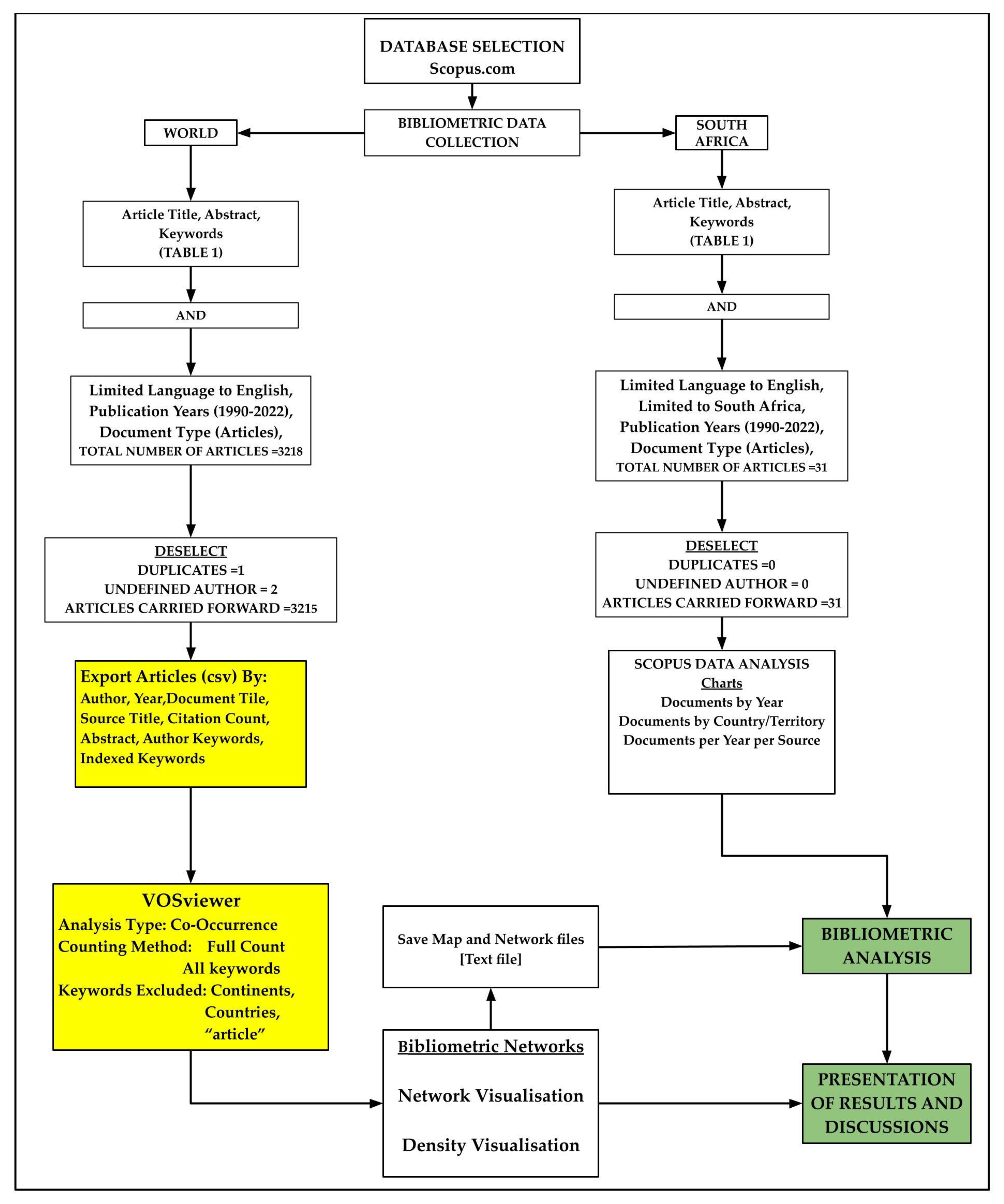
2. Materials and Methods

2.1. Overview

Systematic reviews are qualitative research methods that follow a predefined protocol such as that provided by Systematic reviews and Meta-Analysis PRISMA statement of 2020, which aim to establish an unbiased and comprehensive summary of available evidence in a particular subject area from existing research studies on some specific topic [31]. Systematic reviews are often conducted to answer specific research questions [31,32] and be undertaken in a replicable, scientific, and transparent process with minimum bias from including or excluding studies in the literature review process [33]. This study aims to reveal the trend in using geospatial technologies in archaeology and cultural heritage from 1990 to 2022 and be insightful in understanding paradigms in archaeological investigations using geospatial technology. Systematic reviews are qualitative analyses often employed with scientometric and bibliometric analyses. The scientometric analysis is a quantitative study of science and scientific research focusing on broader trends across disciplines, research, and the evolution of scientific fields [34]. At the same time, bibliometric analysis is a subset of scientometric analysis that mainly focuses on evaluating the performance of researchers, institutions, and journals with specific fields of study [34]. This study uses the Scopus search engine to search for scholarly articles containing keywords or terms fundamental to understanding the use of geospatial technology in archaeology and cultural heritage, as listed in Table 1. Scopus was launched in 2004 and uses Boolean Syntax to perform bibliometric searches; it combines keywords and operators to yield consolidated and relevant results for a given search criteria [32]. The Scopus database has more information for literature searches than other databases, such as the Web of Science (WOS) [7,32,33].
The bibliometric analysis uses document types such as books, conference papers, patents, and others; this study elects scholarly articles mainly because their level of detail allows for more nuanced analysis and a deeper understanding of our research landscape. Scholarly articles undergo rigorous peer-reviewing, papers reveal vivid citation patterns, and scholarly articles are available in most bibliometric databases such as Scopus and follow a standardised format; they contain time-stamped information [32,35]. Among several types of software for visualisation and analysing bibliometric networks, such as co-authorship, co-citation, and co-occurrence networks, is VOSviewer [36]. VOSviewer is widely used in scientometric and bibliometrics analysis to explore and understand relationships between authors, publications, and research topics. In this study, VOSviewer allows the analysis of geospatial technologies in archaeology and cultural heritage by visualising and exploring relationships between different articles, authors, and keywords in the field [36,37]. The unit of analysis in this study is the keywords or terms related to geospatial technologies, archaeology, and cultural heritage, such as “GIS”, “remote sensing”, “spatial analysis”, “archaeological site”, “satellite imagery”, and more.
VOSviewer uses keywords or terms to visualise the keyword co-occurrence network, where the size and proximity of keywords in the visualisation indicate their relationships [36,37]. There are different types of analysis in VOSviewer, and this study elects co-occurrence, bibliographic coupling analysis, and keyword analysis. With co-occurrence analysis, co-occurrence of keywords or terms related to geospatial technologies are identified in the set of documents obtained from the Scopus dataset, and these will help the review to explore the relationship between different geospatial technologies and their application areas and visualise the thematic clusters [36,37]. The bibliographic coupling analysis focuses on the shared references between articles and creates clusters of related articles based on their shared geospatial technology keywords or terms and applications [36,37]. While keyword analysis involves analysing the occurrence and co-occurrence of keywords or phrases related to geospatial technologies in archaeology, this will help the researcher understand the main topics and trends in using geospatial technologies in archaeology and cultural heritage [36,37]. VOSviewer utilises clustering, link strength, and total link strength to visualise and analyse the relationships and patterns within bibliometric networks, providing valuable insights into the structure and dynamics of scholarly information [37]. A cluster refers to a group of related items within a bibliometric network; in this study, clusters represent different thematic areas and keywords or terms related to geospatial technologies used in archaeology and cultural heritage [36,37]. In a co-occurrence network visualisation created using VOSviewer, keywords are represented as nodes, and the links between these nodes represent how often those keywords appear together within the same documents or context. The “Weight” or “Total Link Strength” associated with a link between two keywords signifies the strength of their co-occurrence relationship. This strength is typically determined by the frequency of co-occurrence, meaning how often those two keywords appear together in the analysed dataset [37].
VOSviewer uses three visualisations: network, layout, and density [37]. The purpose of network visualisation is like layout visualisation; both are graphical representations of the relationship between keywords based on their co-occurrence in the same articles collected [36,37]. Each keyword is represented by a node (point), and the connection between keywords by lines, the frequency of co-occurrence determines the strength of the relationship [36,37]. In this review, network visualisation allows for identifying clusters of related keywords, which represent thematic areas or topics within geospatial technologies in archaeology and cultural heritage. In addition, visualisation provides a high-level overview of the key concepts and connections that will help identify trends, central themes, and potential focus areas for further investigations [32]. The size of a node in the co-occurrence network indicates the frequency of a keyword’s appearance in the analysed literature [37]. Larger nodes represent keywords that occur more frequently in association with other keywords. Density visualisations help to identify clusters of keywords that are tightly connected and often appear together [36,37]. In VOSviewer’s density visualisation, both high and low density and colour gradients provide valuable insights into the relationships and interactions within a network [32,37]. In the context of geospatial technologies in archaeology and cultural heritage, high-density and dark colours represent established topics with solid connections within the field. In contrast, low-density, lighter colours represent less explored or less interconnected concepts with weaker links [37]. Findings from these visualisations will focus on the specific clusters or thematic areas with high keyword co-occurrence that are closely related and frequently discussed within geospatial technologies in archaeology and cultural heritage. Further, the information gained guides further research directions, informs collaborations and helps identify gaps in the literature.
Although VOSviewer makes it easier for researchers to identify research trends, key authors, and influential papers in their fields of interest, it requires external intervention to deal with synonyms in bibliometric data. Handling synonyms and similar terms in VOSviewer is crucial for creating meaningful visualisations and analyses. There are several ways of addressing this issue in VOSviewer to make visualisations more intuitive. These include preprocessing the data by either creating consistent terminology and manually cleaning the data to identify and merge synonyms, by creating a synonym list and manually linking the synonyms together in VOSviewer, or by creating thesaurus files and importing these files into VOSviewer or post-processing the results by grouping nodes or terms that represent the synonyms into a single category [36,37].

2.2. Design/Methodology/Approach

2.2.1. Scopus Database Search

The bibliographic data of the journal articles published over the past thirty-three years (1990 to 2022) were extracted from Scopus (www.scopus.com). Figure 1 shows the workflow diagram for this study. The search queries in the English language using search strings where Boolean operators separate the synonyms “OR” and “AND” [7] are shown in Table 1 based on keywords from the geospatial technologies as essayed in the introduction. The search was limited to articles for reasons given in Section 2.1; it is also limited to documents between the years 1990 and 2022 because the archaeological history of South Africa is intertwined with the history of apartheid, which came to an end in the early 1990s [38]; therefore, most documents covering South Africa only feature in the late 20th century on the database. The search was split into two; one was limited to South Africa, and the other was global. This was performed so that trends in geospatial technology development in South Africa could be compared with the rest of the world. The first round of Scopus database search results was exported to a comma-separated value (CSV) format file and opened in an Excel spreadsheet. Using conditional format command in Excel, duplicate document titles and documents with unidentified authors were noted for exclusion in the Scopus bibliometric analysis and export files to VOSviewer. Figure 2, Figure 3 and Figure 4 were generated using the inbuilt function of Scopus bibliometric analysis tools. Bibliographic data consisting of the author, year of publication, document title, source title, citation count, abstract, author keywords and indexed keywords were exported as CSV files for use in VOSviewer.

2.2.2. VOSviewer Visualisation and Analysis of Bibliometric Networks

The bibliographic data exported from Scopus data were imported into VOSviewer, and the type of analysis was set to co-occurrence with a total count of all keywords or terms related to the use and application of geospatial technology in archaeology and cultural heritage. The minimum number of occurrences of a keyword was set to 10 worldwide and was lowered to 5 for South Africa because of the relatively small database. The keywords on verification were set to exclude names of continents, countries, and the word “article” so that the obtained network, overlay and density visualisation could show only the relationships between the spatial technologies, applications, archaeology, and cultural heritage. However, after running VOSviewer with the bibliographic data from the Scopus database, we realised synonyms were an issue. We then created a thesaurus file in a text format, where synonyms for keywords or terms related to geospatial technology tools and applications were grouped. For instance, keywords related to the laser were grouped as laser technology, lidar as lidar technology, laser as laser technology and “3D modeling”, “3D modelling”, etc., as three-dimensional modelling. The thesaurus was imported to VOSviewer to resolve the issue. The VOSviewer program network and density visualisation maps were generated where the size and proximity of keywords in the visualisation indicate their relationships. VOSviewer network files were saved as text files for bibliometric analysis in Excel spreadsheets.

3. Results and Discussion

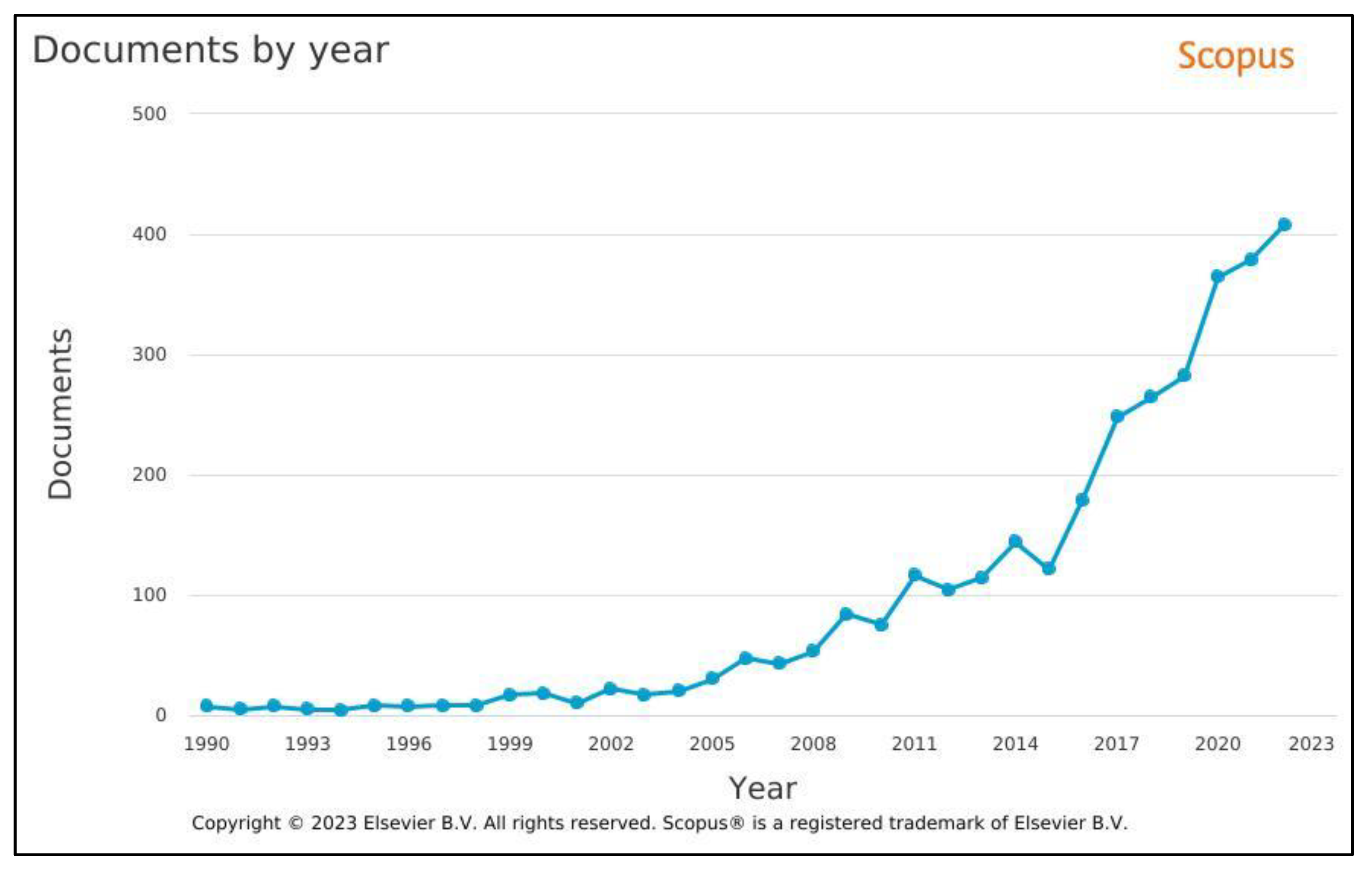
3.1. Trend in Worldwide Documents Published per Year

This study has revealed that geospatial technology is an essential component of archaeological research, aiding in identifying, mapping, and analysing archaeological sites via articles containing keywords or terms associated with the technological tools from 1990 to 2022. Figure 2 and Table 2 are the worldwide Scopus bibliometric analysis results. Figure 2 shows the impetus for geospatial technologies use in archaeology and cultural heritage, as demonstrated by the growth of articles containing the keywords or terms from 7 in 1990 to 406 in 2022. As noted in the literature review, Figure 2 and Table 2 are testimony to the burgeoning number of archaeological investigations that employ geospatial technologies and are revolutionising the archaeological recording of proveniences of artefacts [39]. The worldwide rise in the use of geospatial technologies Figure 2 can be explained by rapid advancements in geospatial technology tools that are more accessible, affordable, and user-friendly, such as GIS, remote sensing, LiDAR, 3D scanning, and related software that have encouraged the integration of the tools in archaeological research and heritage management [40,41]. Other reasons for the worldwide rise are that geospatial technologies offer efficient and accurate data collection methods that enable archaeologists to collect detailed spatial information about sites, artefacts, and landscapes [40]. In addition, geospatial technologies offer enhanced visualisation, advanced spatial analysis, and data integration tools for a better understanding of spatial relationships, patterns and distributions that are very helpful to archaeologists and other researchers [42]. Further, the growth is also explained by the ability of geospatial technology tools to assist in interdisciplinary collaboration, allow for digital documentation and preservation, assist in heritage management by providing data-driven insights into site conditions and potential threats, and offer educational opportunities for students and the public who would like to explore archaeological sites and artefacts virtually [41,43].

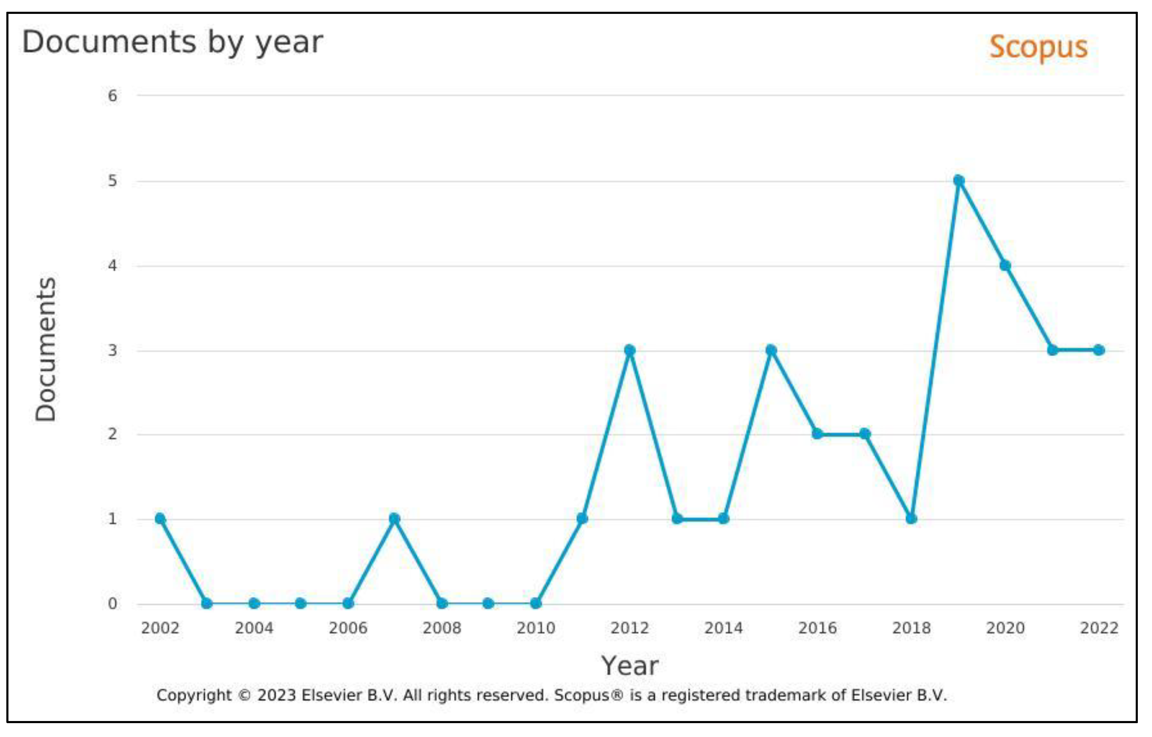
3.2. Trend in South Africa Documents Published per Year

Figure 3 and Table 3 depict the trend in the growth of archaeological investigations employing geospatial technologies. The worldwide rise in the use of geospatial technologies is not shown in South African space in Figure 3. Only 31 articles were found in the Scopus database from 1990 to 2022. There was a peak of five articles in 2019, which dropped to three in 2021; this could be explained by the same worldwide restrictions on outdoor archaeological investigations brought by the COVID-19 pandemic restrictions.
The slow growth or limited adoption of geospatial technologies in archaeology and cultural heritage in South Africa could be influenced by a range of factors. Below are some potential reasons:
  • Lack of Awareness: Many archaeology and cultural heritage practitioners might be unaware of geospatial technologies’ potential benefits and applications [44,45]. Awareness campaigns and educational initiatives are needed to showcase how these technologies can enhance research and preservation efforts.
  • Limited Training: Geospatial technologies require specialised skills in GIS, remote sensing, photogrammetry, and LiDAR [46]. If archaeologists and cultural heritage professionals lack access to training programs and workshops, they may hesitate to adopt these technologies.
  • Resource Constraints: Acquiring the necessary hardware, software, and data for geospatial technologies can be costly [46,47]. Archaeological and cultural heritage projects often have limited budgets, making it difficult to invest in the technology and expertise required.
  • Data Accessibility: The availability of accurate and high-quality spatial data is crucial for geospatial analysis [46]. If relevant data are not easily accessible or are lacking, it can hinder the effective use of these technologies.
  • Integration Challenges: Incorporating geospatial technologies into existing archaeological and cultural heritage workflows might require changes in methodologies and practices [44]. This transition can be perceived as challenging and time-consuming.
  • Cultural Sensitivity: In cultural heritage preservation, there can be concerns about using advanced technologies that may disturb or damage fragile artefacts or sites [48]. Overcoming these concerns requires careful planning and understanding of the technology’s impact.
  • Regulatory Hurdles: Archaeological and heritage sites often have legal protections and regulations to prevent damage or destruction [48]. Using geospatial technologies might require approvals, permits, or compliance with specific guidelines, which can slow down adoption.
  • Perceived Complexity: Geospatial technologies can be perceived as complex, especially for professionals who do not have a background in technology or geography [44]. This perception can deter individuals from attempting to integrate these tools.
  • Institutional Support: Institutional support from archaeological and cultural heritage organisations and government bodies plays a crucial role. Adopting may be slower if there is a lack of encouragement or incentives for using geospatial technologies.
  • Collaboration Gaps: Effective use of geospatial technologies often involves collaboration between archaeologists, cultural heritage experts, geographers, and technologists [45,46]. Limited cross-disciplinary collaboration can hinder progress.
  • Educational Curriculum: Including geospatial technologies in archaeological and cultural heritage educational curricula might be limited. Graduates entering the field might lack exposure to these tools.
In order to address these challenges, efforts should be made to provide training opportunities, raise awareness about the benefits, develop funding sources for technology adoption, promote cross-disciplinary collaboration, and advocate for policies that support integrating geospatial technologies into archaeological and cultural heritage work in South Africa.

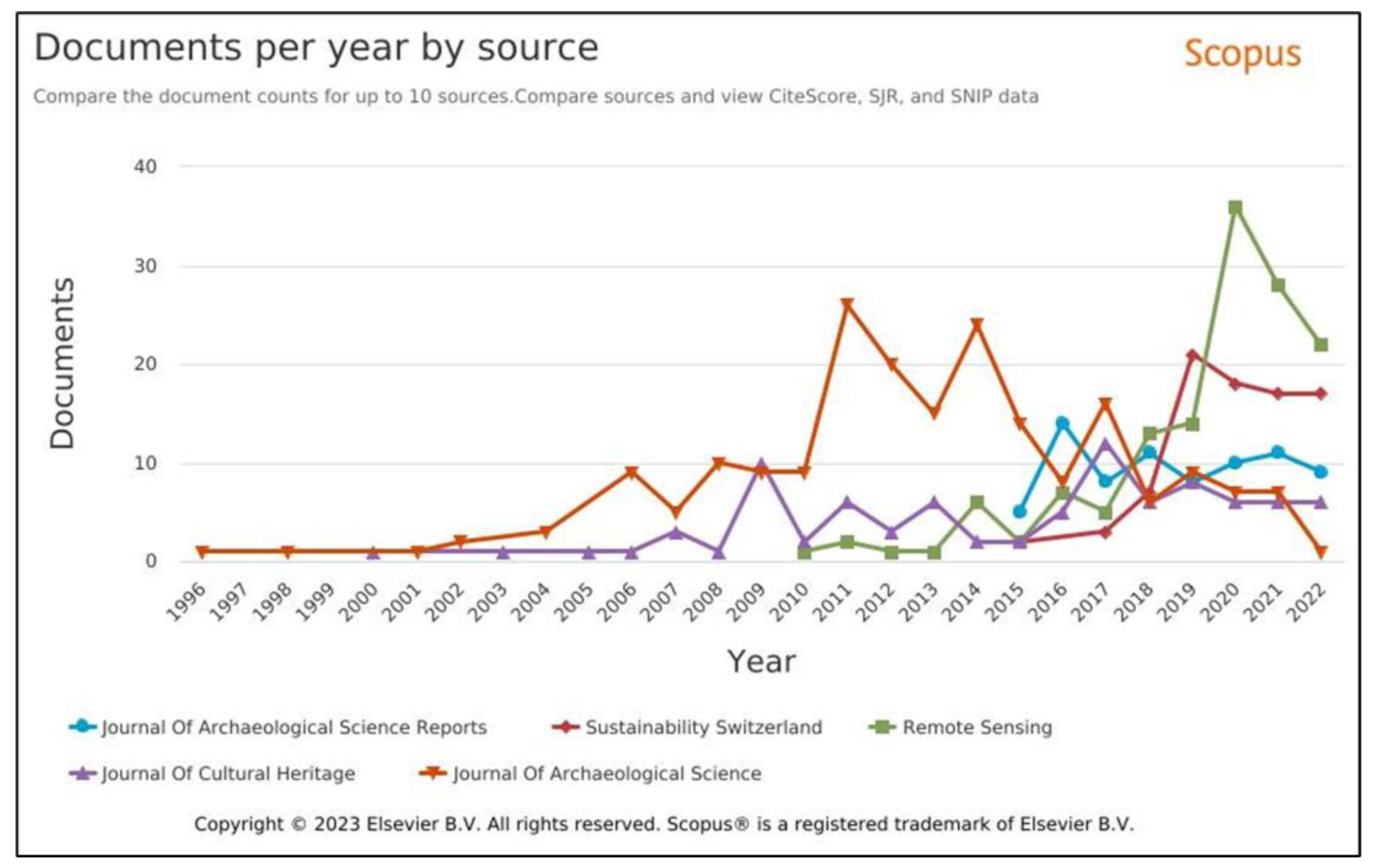
3.3. Trends in Worldwide Published Articles per Journal Results and Discussion

According to the Scopus database, the results and discussion are based on the first top five journals. The assumption is that the trends established represent the general trend in publishing articles related to geospatial technologies, archaeology, and cultural heritage. Figure 4 depicts the trend in the publications of articles containing keywords or terms relating to archaeology and cultural heritage. Although the Journal of Archaeological Science has been the journal of choice and the dominant journal from 1996 to 2022, with a peak of 26 articles in 2011, it lost its dominance to Remote Sensing Journal Figure 4 and Table 4. The Journal of Archaeological Science is subscription-based and interdisciplinary, implying that articles must combine archaeological methods and scientific techniques. Therefore, manuscripts submitted must demonstrate a strong integration of both disciplines. The emergence of other journals with a singular field focus, such as the Remote Sensing Journal, with its first publication in 2010, Table 4, took over the dominance because authors’ supposed preference could have shifted to journals with relaxed adherence to an interdisciplinary approach. Another reason for the supremacy of the Remote Sensing Journal, which started with 1 article in 2010 and rose to 36 articles in 2020, is attributed to the journal’s niche focus, which is closely aligned with the intersection of new geospatial technologies, archaeology, and cultural heritage. In addition, the COVID epidemic, which restricted archaeological investigations to indoor activities, favoured remote sensing technologies worldwide. The pandemic contributed to the boom in the number of articles published in the Remote Sensing Journal; there was a peak of 36 articles in 2020 during the height of the COVID restrictions. The loss in the dominance of the subscription-based journal, the Journal of Archaeological Science, is also attributed to the emergence of open-access journals such as the Journal of Archaeological Science; Reports, the Journal of Cultural Heritage, and the Sustainability Switzerland. These open-access journals offer freely accessible articles to readers and promote broader dissemination of research findings. With the worldwide boom in internet access, these journals have increased visibility, leading to more citations. Therefore, researchers and institutions from various economic backgrounds tend to favour them because they can access research without facing paywalls.
South Africa has significantly low numbers in the top worldwide publications or journals with keywords or terms related to geospatial technology, archaeology, and cultural heritage, as shown in Figure 3, Table 3 and Table 5. From Table 5, it can be deduced that South African-based researchers and institutions favour subscription-based journals. Even though open-access journals offer a variety of advantages, such as broader accessibility, increased visibility, and reduced access barriers, they require Article Processing Charges (APCs). They can be prohibitive to researchers without funding. Some of them are predatory journals and are perceived by some researchers as of lower prestige and, therefore, shunned. Some well-established subscription-based journals, such as the Journal of Archaeological Science and Remote Sensing Journal, are considered prestigious due to their long history and rigorous peer-review processes. They, therefore, become the first choice for some researchers in South Africa. In addition, authors are not required to pay for APCs to publish in subscription-based journals, which can benefit researchers without funding for publication fees.

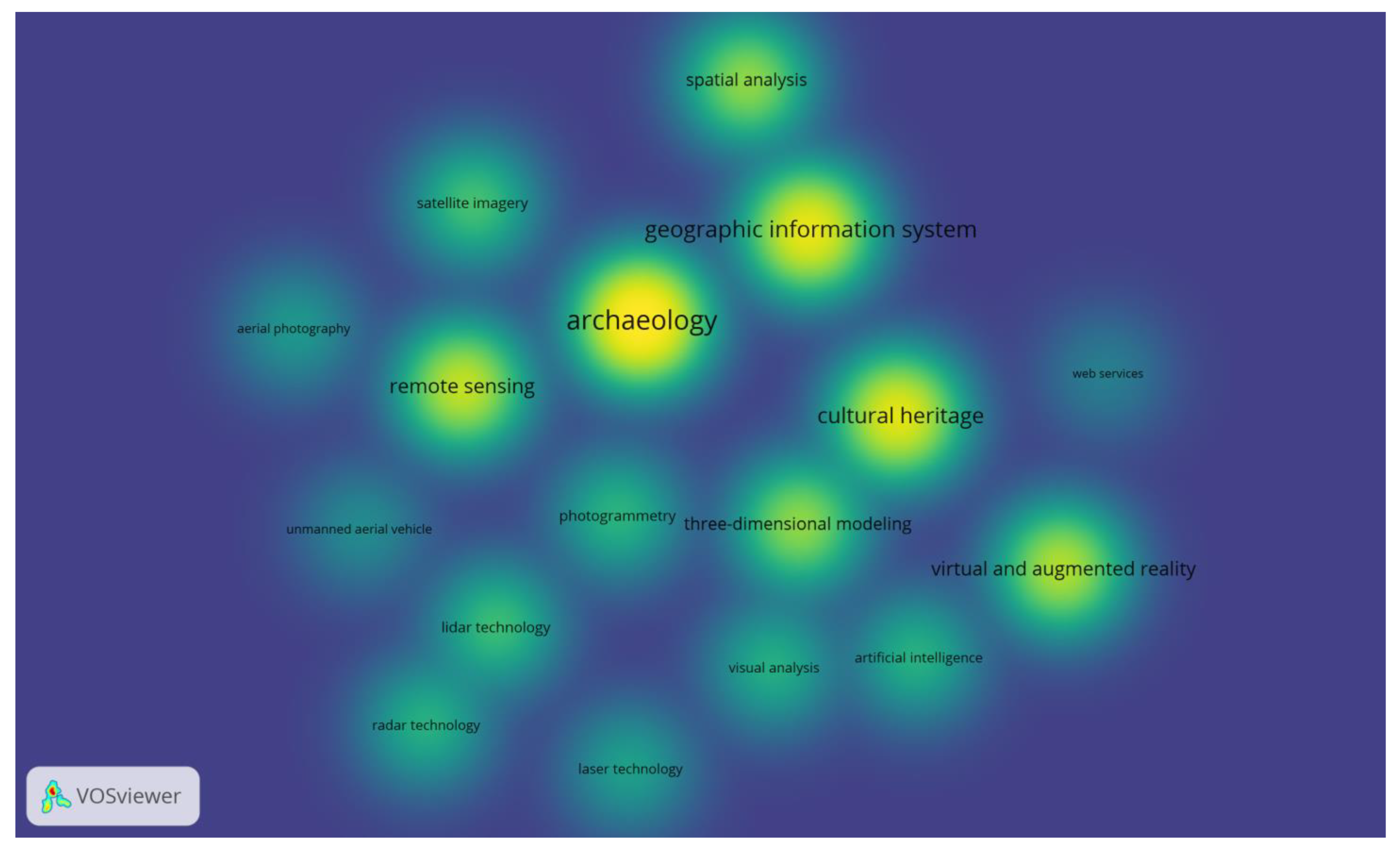
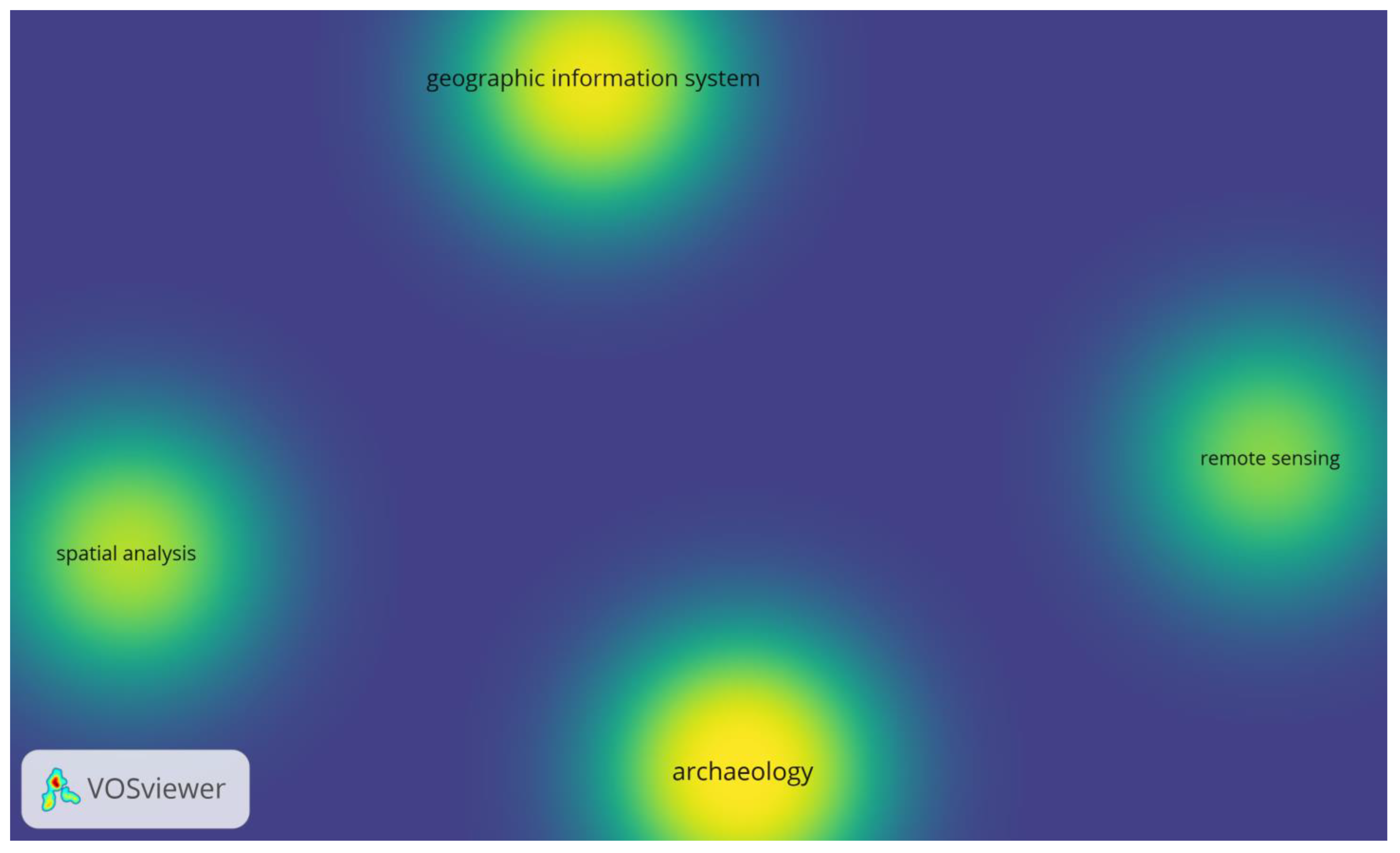
3.4. Density Visualisation and Analysing Bibliometric Networks

Co-occurrence analysis in VOSviewer was used to visualise the keyword or term network used in geospatial technologies, archaeology, and cultural heritage co-occurrence networks. The aim was to explore the relationships between these keywords or terms in geospatial technology, archaeology, and cultural heritage and to visualise thematic clusters. The size and proximity of keywords in the visualisation indicated their relationships. As discussed, VOSviewer uses a colour gradient to represent different density levels. In the Viridis colour scale, Figure 5 and Figure 6, the pale colours indicate low density and the intense colour (yellow) indicates high density. In Figure 5, the high-density clusters are archaeology, cultural heritage, geographic information system and remote sensing; these keywords and themes are closely related and frequently discussed. In addition, these high-density clusters represent contemporary, traditional disciplines that have established interdisciplinary connections and collaborations. Areas with relatively lower density (light yellow), Figure 5, such as virtual and augmented reality, three-dimensional modelling and spatial analysis, represent geospatial technology tools and themes already and still being explored. While lower density areas such as radar technology, lidar technology, laser technology, artificial intelligence, visual analysis, and others in Figure 5 represent geospatial technology tools and research themes that are less explored or less interconnected concepts that have potential gaps in research or underexplored topics that might be worth investigating in archaeology and cultural heritage. For South Africa, the density visualisation, Figure 6, shows three geospatial technology tools, geographic information system, spatial analysis, and remote sensing and one application, archaeology. However, the absence of the density visualisation of various geospatial technologies and applications, as presented in Figure 5, suggests gaps in research and underexplored topics worth investigating in South Africa. Density visualisation, when used to analyse the trend in the use of geospatial technologies in archaeology and cultural heritage, serves the purpose of highlighting and understanding the evolving thematic clusters and research focus over time. In both Worldwide and South Africa-based density visualisation, this review analysed a static period from 1990 to 2022, and the results could be more comprehensive regarding tracking changes over time and visualising research evolution; however, these would require density visualisation at different periods. Finally, it should be noted that as trends and research priorities evolve, other clusters may gain or lose prominence.

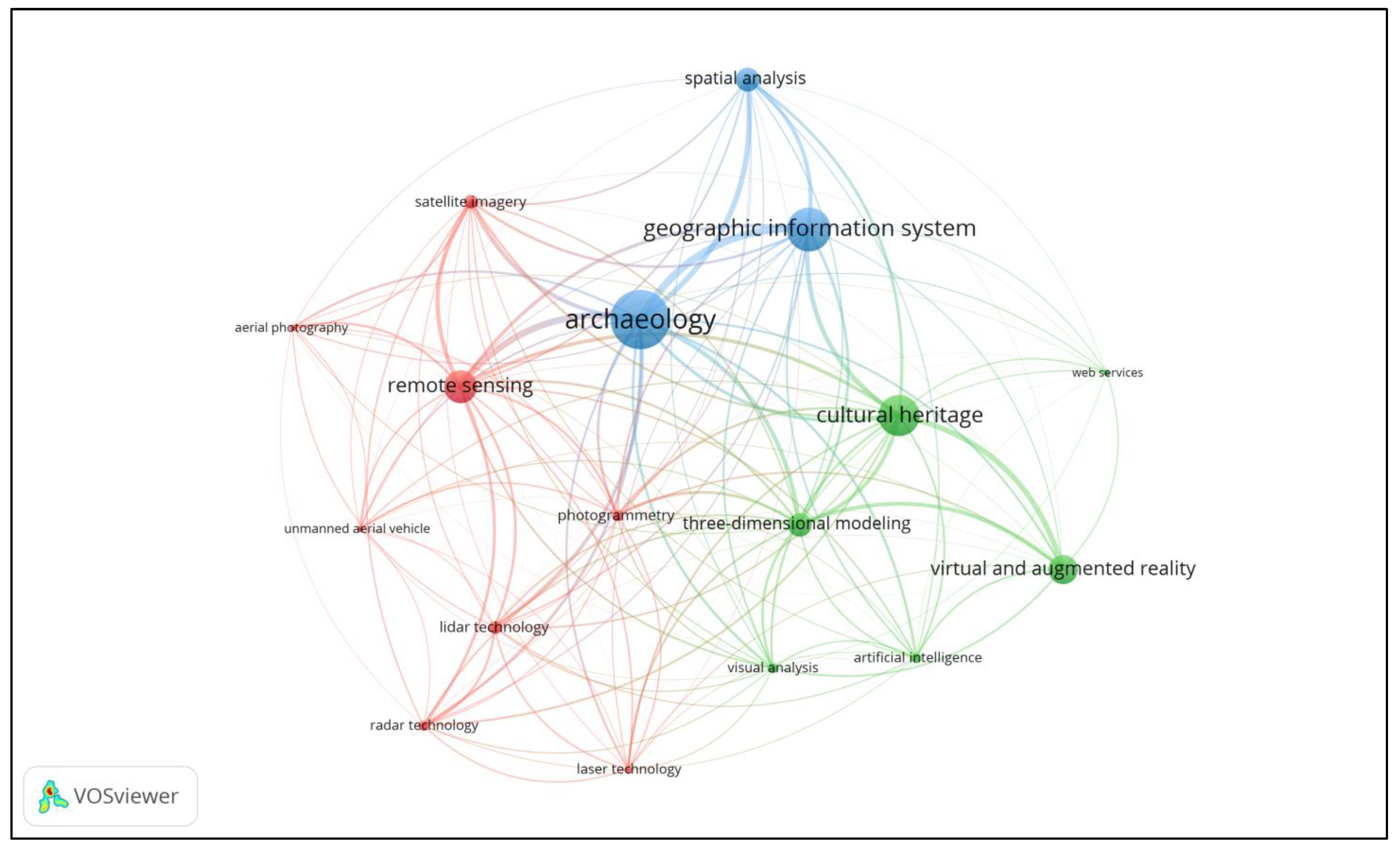
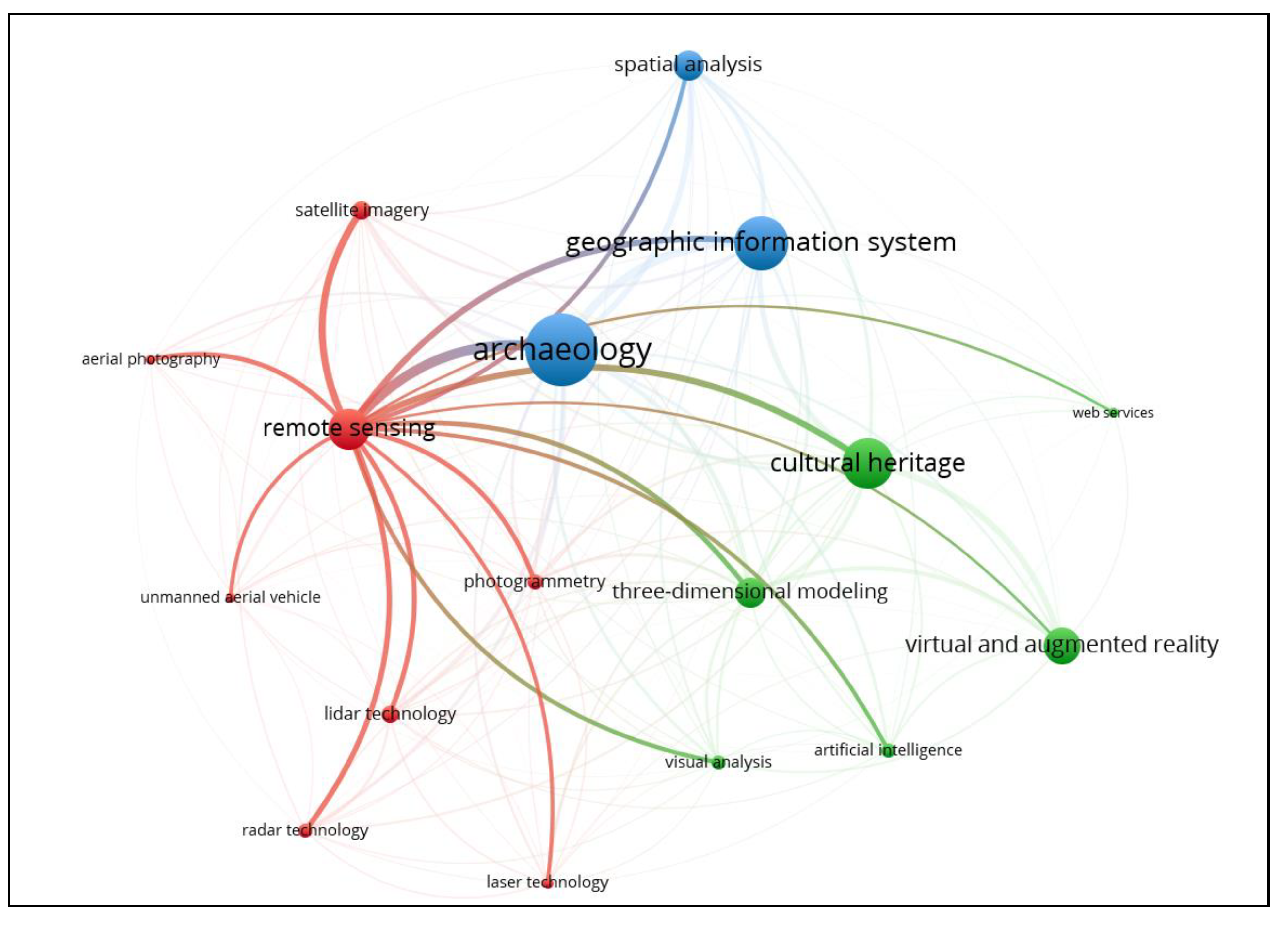
3.5. Network Visualisation and Analysing Bibliometric Networks

Figure 7, Figure 8, Figure 9 and Figure 10 and Table 6 show the network visualisation maps and the obtained map structural information related to the geospatial technology tools for the keywords or terms used Worldwide and South Africa related to geospatial technologies and cultural heritage in the literature review. In this review, three clusters (related keywords, which represent thematic areas or topics within geospatial technologies in archaeology and cultural heritage) were identified. Cluster 1 with 8 items (red), cluster 2 with 6 items (green) and cluster 3 with 3 items (blue), as shown in Figure 7. The key concepts that shape research in the use of geospatial technologies in archaeology and cultural heritage, according to the Scopus database 1990–2020, are shown as central hubs (large nodes) and network-weighted strengths within the network. These significant hubs represent the focus or theme or distinct knowledge domains within the World Wide Web are shown in Figure 7 as cultural heritage (green), archaeology (blue), geographic information systems (blue), remote sensing (red), virtual and augmented reality (green), and spatial analysis (blue). As discussed in the preview, the link length between two nodes represents the strength or degree of co-occurrence between the corresponding keywords. Shorter links indicate stronger relationships, while longer links suggest weaker connections. From Figure 7, the central themes of research that use geospatial tools are archaeology, cultural heritage and spatial analysis. The prominent geospatial tools are remote sensing, geographic information systems and virtual and augmented reality.
Table 6 shows the top 20 keywords or terms ranked in order of the weighted total link strength; it can be deduced that the geospatial technology tools highlighted in red are leading research in archaeology and cultural heritage and follow that ranking according to the searched Scopus database from 1990 to 2022.
Remote sensing technologies Figure 8, prominent tools (large dots) in the review period are lidar, satellite imagery and optical radar. Examples from the Scopus database are Modern flint mining landscapes and flint knapping evidence from the Kraków Gunflint Production Centre—What we know from LiDAR and field survey [49], Airborne LiDAR-derived digital elevation model for archaeology [50], Documentation of archaeology-specific workflow for airborne LiDAR data processing [51], New developments in the use of spatial technology in archaeology [44] and several others. These are identified as the significant contributors of information in remote sensing that help identify and document archaeological features (archaeology is the closest application to remote sensing Figure 8) that are not easily visible from the ground. Cultural heritage and spatial analysis tend to be distant from remote sensing in Figure 8, implying these terms are infrequently used with remote sensing and, therefore, potential research areas to be pursued using the technology tool. In addition, in remote sensing cluster two, Figure 8, geospatial technologies such as radar technology, aerial photography, and unmanned aerial vehicle (UAV) represented by the small dots and low-weighted total link strengths present gaps or unexplored research areas in remote sensing and novel application in archaeology and cultural heritage.
Geographic Information Systems (GIS) are software that allow archaeologists to capture, store, manipulate, analyse, and visualise geospatial data, including maps, satellite imagery, and various layers of archaeological information. In Figure 9, the major application areas of the software are archaeology, cultural heritage, and spatial analysis. Examples from the Scopus database are A GIS-based Methodology to Explore and Manage the Historical Heritage of Rabat City (Morocco) [52], GIS-based precise predictive model of mountain beacon sites in Wenzhou, China [53], ACTA IMEKO Photogrammetry and GIS to investigate modern landscape change in an early Roman colonial territory in Molise (Italy) [54] and several others. Remote sensing is the prominent tool that is used to gather information for use by GIS applications. According to Figure 9, applications of GIS software in conjunction with spatial analysis, lidar technology, visual analysis, artificial intelligence, laser technology, three-dimensional modelling, etc., (small dots) represent gaps and potential research areas.
Virtual and Augmented Reality applications are technologies that enable the visualisation and exploration of archaeological sites and reconstructions in immersive and interactive ways. Figure 10 shows these as the significant geospatial tools used in cultural heritage; they also provide information to GIS and archaeology in the review period 1990 to 2022. Notable examples from Scopus database are Digital Creativity and the Regional Museum: Experimental Collaboration at the Convergence of Immersive Media and Exhibition Design [55], 3D Documentation and Visualisation of Cultural Heritage Buildings through the Application of Geospatial Technologies [56], Developing Augmented Reality Lontar Prasi Bali as an E-learning Material to Preserve Balinese Culture [57], Accurate 3D models in both geometry and texture: An archaeological application [58] and several others. Web services, visual analysis, artificial intelligence, photogrammetry, etc., Figure 10 (small dots) need to be explored and present gaps for research in cultural heritage studies.

4. Findings

From the systematic review of literature containing keywords or terms related to geospatial technologies used in archaeology and cultural heritage, this review reinforces what is already essayed in some non-systematics reviews about geospatial technology tools. These tools are an essential component of archaeological research.
  • Geospatial technology aids in identifying, mapping, and analysing archaeological and cultural heritage sites.
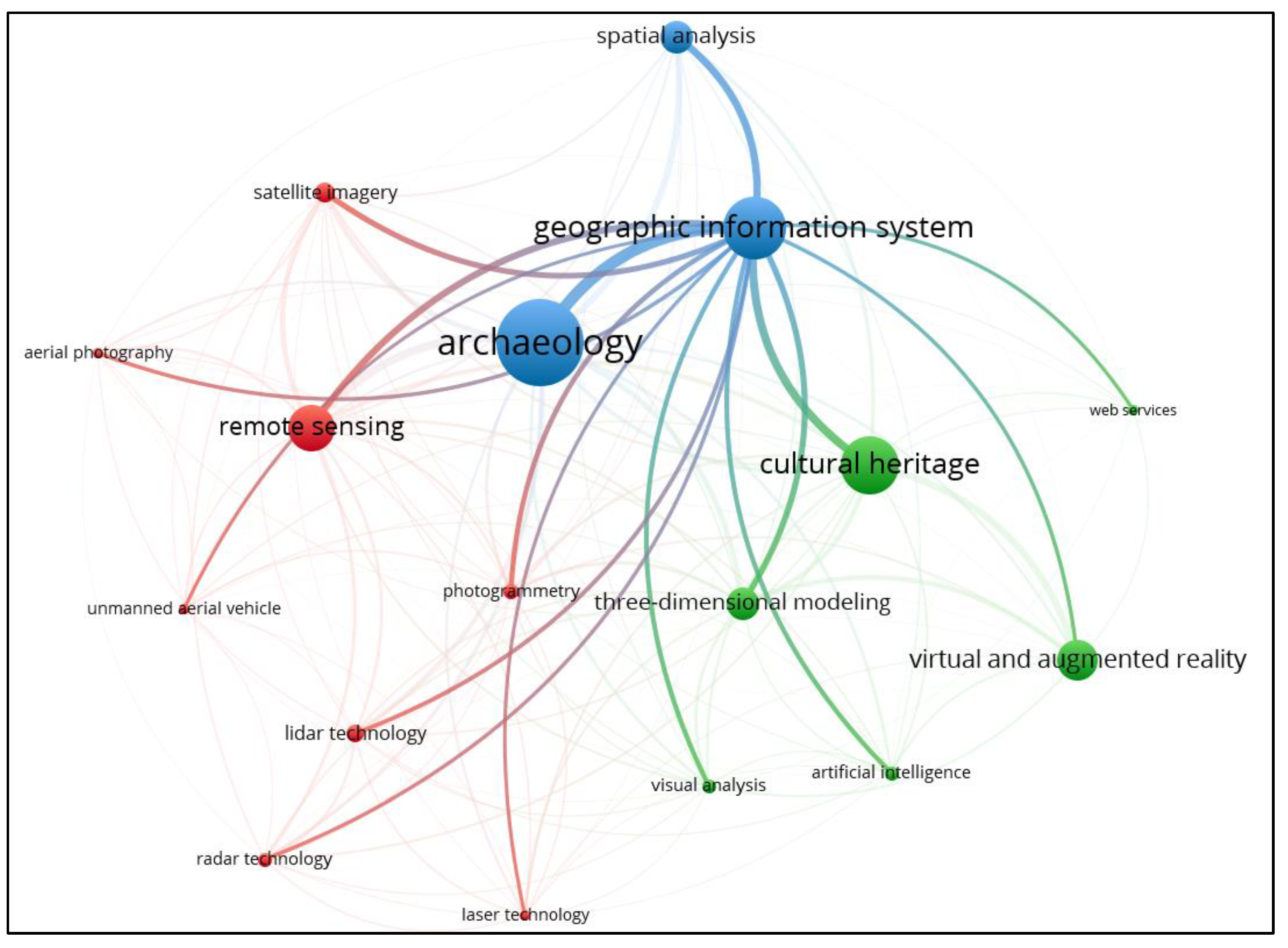
  • Geographic Information System, Figure 9, is the prominent software that allows archaeologists to capture, store, manipulate, analyse, and visualise geospatial data, including maps, satellite imagery, and various layers of archaeological information. Growth in GIS could also be attributed to the proliferation of open-source GIS software and the development of machine learning algorithms. Web mapping services will impact the future growth of geospatial applications in archaeology.
  • These tools provide specialised spatial analysis functions that help archaeologists understand patterns, relationships, and trends in archaeological data. The dot size in Figure 9 shows that they are relatively less explored concepts in archaeology and cultural heritage and present gaps worth investigating.
  • Spatiotemporal analysis and spatial modelling tools are subsets of spatial analysis tools, Figure 9. These are often synchronised or integrated with GIS; this review shows that they are less explored or less interconnected with concepts in archaeological and cultural heritage studies and, therefore, present potential research gaps that might be worth investigating.
  • Spatial Databases (data set), Figure 9, are databases designed for storing and managing geospatial information. The dot size in Figure 9 shows that they are relatively less explored concepts in archaeology and cultural heritage and present gaps worth investigating. Innovation in data structures and data architecture for extensive data handling and storage will impact the future growth of applications in archaeology.
  • Remote sensing technologies, Figure 8, are primary geospatial technology tools in archaeology and cultural heritage for identifying and documenting archaeological features that are not easily visible from the ground. However, in this review period, tools such as aerial photography, optical radar, and unmanned aerial vehicle (UAV) show that they are relatively less explored tools in remote sensing technologies for archaeology and cultural heritage and present gaps worth investigating. Lidar and satellite imagery are already well-explored tools in remote sensing applications; however, they are distant from archaeology and cultural heritage as stand-alone tools Figure 7, and, therefore, present opportunities for novel applications. Open, free, and accessible data from earth observation missions such as Landsat and Sentinel satellite series may be driving the growth in remote sensing. Cloud computing platforms such as Google Earth Engine and Digital Earth Africa will likely drive future growth.
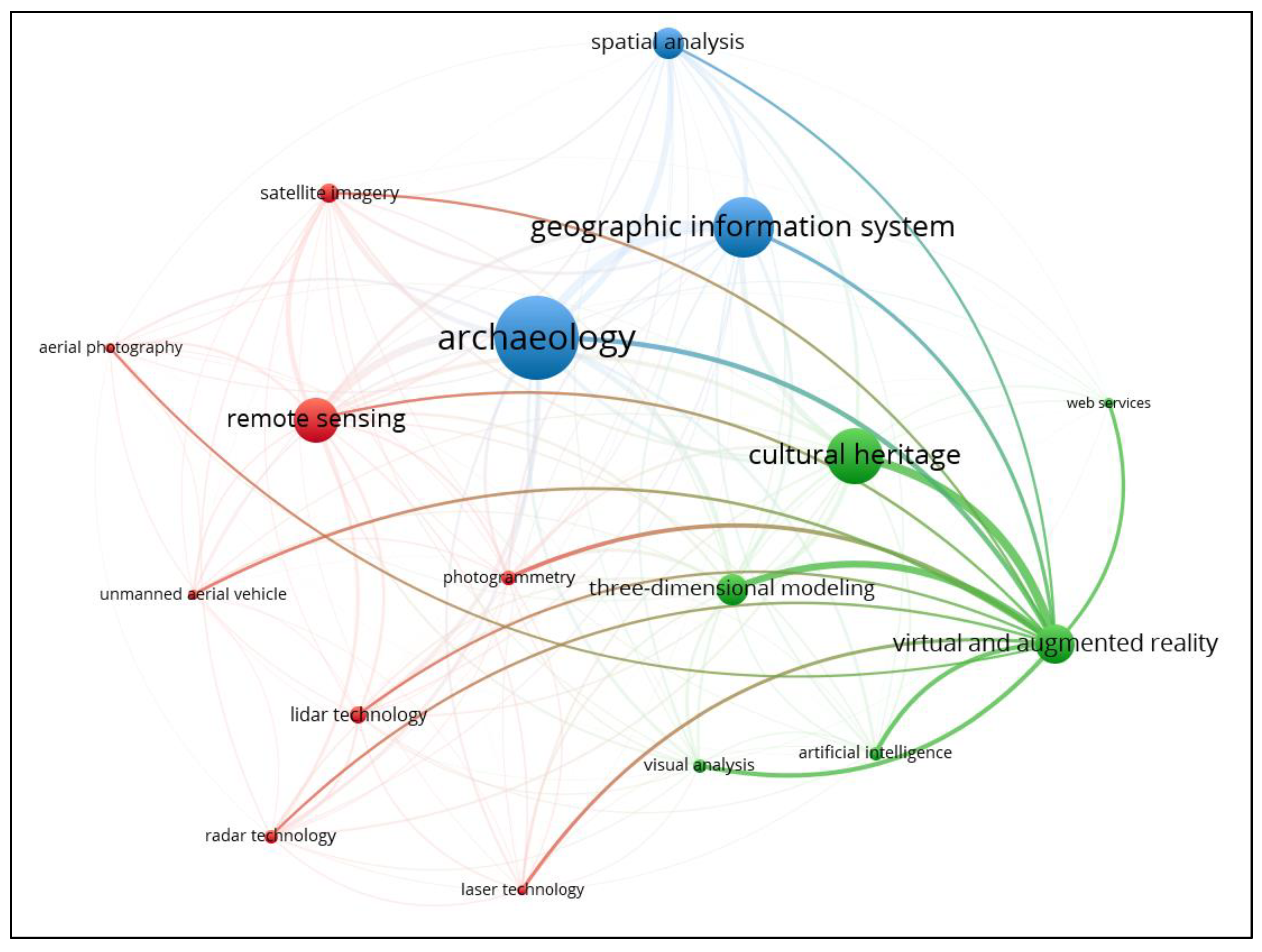
  • Virtual Reality and Augmented Reality applications, Figure 10, are emerging and prominent technologies in cultural heritages; they enable the visualisation and exploration of archaeological sites and reconstructions in immersive and interactive ways. Associated tools or concepts such as 3D modelling, 3D computer graphics, 3D reconstruction, photogrammetry and artificial intelligence are less explored and present potential research gaps worth investigating in archaeology and cultural heritage.
  • Geographic information systems and spatial analysis are the primary geospatial technology tools used in South Africa for archaeological and cultural heritage investigations in the review period.
If national funds permit, all the research growth areas established in this review are worth investigating.

5. Conclusions

This study aimed to reveal the trends in the use of geospatial technologies in archaeological investigations via the search engine Scopus that support the literature review on advancement in the application of geospatial technology in archaeology in South Africa. Overall, there has been growth in digital technologies since the beginning of the twenty-first century that supports spatial archaeology. The search for keywords associated with geospatial technologies on the Scopus database reveals how modern archaeological studies are now a significant discipline of spatial sciences and how the discipline enjoys the tools of geomatics engineering for establishing temporal and spatial controls on the material being studied and observing patterns in the archaeological records. While total stations and GNSS technologies revolutionalised the practice of archaeological investigations, as seen by the florescence of application areas that, in one way or another, support the goals and objectives of the archaeology discipline, they cannot match remote sensing technologies. This study exposed the new synthesis in archaeological studies, which has a new paradigm that uses geospatial technologies. However, South Africa needs to catch up, as judged by the number of published documents on the Scopus database, despite having many sites that house archaeological phenomena features, such as the Cradle of Humankind. As alluded to by different reviews on geospatial technologies, the most comprehendible reason for the limited uptake of these advanced technologies is the low-budget research projects that cannot afford the high-end technologies. However, recent advancements in new technologies and methods in archaeological prospecting have seen the deployment of portable, low-cost geospatial technologies with high-quality results that are reliable, detailed, accurate and precise, which might introduce changes in the statistics of studies that employ geospatial technologies. One assumption might be that South Africa still has conservative archaeologists who feel geospatial technologies are intrusive in archaeological methodologies and might introduce bias in archaeology. If it is true, then positive discussions in the discipline should shift to theoretical understanding of spatial technologies or functionalist approaches in archaeology. In addition, interdisciplinary collaboration should be encouraged between archaeologists and technologies specialists.

Author Contributions

Conceptualisation, C.M. and P.M.; methodology, C.M. and P.M.; software, C.M.; validation, C.M.; formal analysis, C.M.; investigation, C.M.; writing—original draft preparation, C.M.; writing—review and editing, C.M.; visualisation, C.M.; supervision, P.M. All authors have read and agreed to the published version of the manuscript.

Funding

This research received no external funding.

Data Availability Statement

Not applicable.

Conflicts of Interest

The authors declare no conflict of interest.

References

  1. DiBiase, D.; Corbin, T.; Fox, T.; Francica, J.; Green, K.; Jackson, J.; Jeffress, G.; Jones, B.; Jones, B.; Mennis, J. The New Geospatial Technology Competency Model: Bringing Workforce Needs into Focus. Urisa J. 2010, 22, 55. [Google Scholar]
  2. Aina, Y.A. Applications of Geospatial Technologies for Practitioners: An Emerging Perspective of Geospatial Education. In Emerging Informatics—Innovative Concepts and Applications; IntechOpen: London, UK, 2012. [Google Scholar] [CrossRef]
  3. Klinkenberg, B. Geospatial Technologies and the Geographies of Hope and Fear. Ann. Assoc. Am. Geogr. 2007, 97, 350–360. [Google Scholar] [CrossRef]
  4. Wheatley, D.; Gillings, M. Spatial Technology and Archaeology: The Archaeological Applications of GIS; CRC Press: Boca Raton, FL, USA, 2013; ISBN 1466576618. [Google Scholar]
  5. Nsanziyera, A.F.; Rhinane, H.; Oujaa, A.; Mubea, K. Gis and Remote-Sensing Application in Archaeological Site Mapping in the Awsard Area (Morocco). Geosciences 2018, 8, 207. [Google Scholar] [CrossRef]
  6. Linnenluecke, M.K.; Marrone, M.; Singh, A.K. Conducting Systematic Literature Reviews and Bibliometric Analyses. Aust. J. Manag. 2020, 45, 175–194. [Google Scholar] [CrossRef]
  7. Carrera-Rivera, A.; Larrinaga, F.; Lasa, G. Context-awareness for the design of Smart-product service systems: Literature review. Comput. Ind. 2022, 142, 103730. [Google Scholar] [CrossRef]
  8. Brembs, B. Prestigious Science Journals Struggle to Reach Even Average Reliability. Front. Hum. Neurosci. 2018, 12, 37. [Google Scholar] [CrossRef]
  9. Burnham, J.F. Scopus Database: A Review. Biomed. Digit. Libr. 2006, 3, 1. [Google Scholar] [CrossRef]
  10. Shafer, H.J. Goals of Archaeological Investigation. In Field Methods in Archaeology; Hester, T.R., Shafer, H.J., Feder, K.L., Eds.; Routledge: Oxfordshire, UK, 2016; pp. 5–20. ISBN 9781598744286. [Google Scholar]
  11. Feder, K.L. Data Preservation: Recording and Collection. In Field Methods in Archaeology; Hester, T.R., Shafer, H.J., Feder, K.L., Eds.; Routledge: Oxfordshire, UK, 2016; ISBN 9781598744286. [Google Scholar]
  12. Feder, K.L. Site Survey. In Field Methods in Archaeology; Hester, T.R., Shafer, H.J., Feder, K.L., Eds.; Routledge: Oxfordshire, UK, 2016; pp. 41–68. [Google Scholar]
  13. Kruger, A.; Patrick, R.-Q.; Elliott, M. Multimodal Spatial Mapping and Visualisation of Dinaledi Chamber and Rising Star Cave. S. Afr. J. Sci. 2016, 112, 11. [Google Scholar] [CrossRef]
  14. Reilly, P. Towards a Virtual Archaeology. In CAA90. Computer Applications and Quantitative Methods in Archaeology 1990; Tempus Reparatum: Oxford, UK, 1991; pp. 132–139. [Google Scholar]
  15. Shafer, H.J. Research Design and Sampling Techniques. In Field Methods in Archaeology; Thomas, R.H., Harry, J.S., Kenneth, L.F., Eds.; Routledge: Oxfordshire, UK, 2016; pp. 21–40. ISBN 1315428393. [Google Scholar]
  16. Garrison, T.G.; Chapman, B.; Houston, S.; Román, E.; Garrido López, J.L. Discovering Ancient Maya Settlements Using Airborne Radar Elevation Data. J. Archaeol. Sci. 2011, 38, 1655–1662. [Google Scholar] [CrossRef]
  17. Ainsworth, S.; Bowden, M.; Mcomish, D.; Pearson, T. Understanding the Archaeology of Landscapes, 2nd ed.; Historic England: Swindon, UK, 2017. [Google Scholar]
  18. Lazo, J.F. Detection of Archaeological Sites from Aerial Imagery Using Deep Learning. Master’s Thesis, Lund University, Lund, Sweden, 2005. [Google Scholar]
  19. Latham, A.G.; Herries, A.; Quinney, P.; Sinclair, A.; Kuykendall, K. The Makapansgat Australopithecine Site from a Speleological Perspective. Geol. Soc. Spec. Publ. 1999, 165, 61–77. [Google Scholar] [CrossRef]
  20. David, A. Finding Sites. In Archaeology in Practice: A Student Guide to Archaeological Analyses; Balme, J., Paterson, A., Eds.; John Wiley & Sons: Hoboken, NJ, USA, 2006; pp. 1–38. [Google Scholar]
  21. Hester, T.R. Chronological Methods. In Field Methods in Archaeology; Hester, T.R., Shafer, H.J., Feder, K.L., Eds.; Routledge: Oxfordshire, UK, 2016; pp. 319–344. [Google Scholar]
  22. Hester, T.R. Methods of Excavation. In Field Methods in Archaeology; Hester, T.R., Shafer, H.J., Feder, K.L., Eds.; Routledge: Oxfordshire, UK, 2016; pp. 69–112. [Google Scholar]
  23. Thomas, C.R. (50) Coordinates in Archaeology—YouTube. Available online: https://www.youtube.com/watch?v=GacWDH58CKE (accessed on 3 July 2021).
  24. Ashmore, W. “Decisions and Dispositions”: Socializing Spatial Archaeology. Am. Anthropol. 2002, 104, 1172–1183. [Google Scholar] [CrossRef]
  25. Holdaway, S.; Witter, D.; Fanning, P.; Musgrave, R.; Cochrane, G.; Doelman, T.; Greenwood, S.; Pigdon, D.; Reeves, J. New Approaches to Open Site Spatial Archaeology in Sturt National Park, New South Wales, Australia. Archaeol. Ocean. 1998, 33, 1–19. [Google Scholar] [CrossRef]
  26. Simek, J.F. Integrating Pattern and Context in Spatial Archaeology. J. Archaeol. Sci. 1984, 11, 405–420. [Google Scholar] [CrossRef]
  27. Trigger, B.; Clarke, D.L. Spatial Archaeology. Man 1977, 12, 538. [Google Scholar] [CrossRef]
  28. Kuykendall, K.; Štrkalj, G. A History of South African Palaeoanthropology. In A Search for Origins: Science, History and South Africa’s ‘Cradle of Humankind’; Bonner, P., Esterhuysen, A., Jenkins, T., Eds.; Wits University Press: Johannesburg, South Africa, 2007; pp. 45–72. ISBN 1868146693. [Google Scholar]
  29. Kuykendall, K. Fossils Hominids of The “Cradle of Humankind”. In A Search for Origins: Science, History and South Africa’s ‘Cradle of Humankind’; Bonner, P., Esterhuysen, A., Jenkins, T., Eds.; Wits University Press: Johannesburg, South Africa, 2007; pp. 73–95. ISBN 1868146693. [Google Scholar]
  30. Armstrong, B.J.; Blackwood, A.F.; Penzo-Kajewski, P.; Menter, C.G.; Herries, A.I.R. Terrestrial Laser Scanning and Photogrammetry Techniques for Documenting Fossil-Bearing Palaeokarst with an Example from the Drimolen Palaeocave System, South Africa. Archaeol. Prospect. 2018, 25, 45–58. [Google Scholar] [CrossRef]
  31. Higgins, J.P.T.; Green, S. Cochrane Handbook for Systematic Reviews of Interventions Version 5.1.0 [Updated March 2011]. The Cochrane Collaboration. 2011. Available online: https://www.cochrane-handbook.org/ (accessed on 29 August 2011).
  32. Ozturk, G.B.; Ozen, B. Technology Use in Archeology and Historical Building Research: A Citation, Bibliographic Coupling, and Document Analysis. J. Constr. Eng. Manag. Innov. 2020, 3, 141–157. [Google Scholar] [CrossRef]
  33. Carrera-Rivera, A.; Ochoa-Agurto, W.; Larrinaga, F.; Lasa, G. How-to Conduct a Systematic Literature Review: A Quick Guide for Computer Science Research. MethodsX 2022, 9, 101895. [Google Scholar] [CrossRef]
  34. Bornmann, L.; Marx, W. How to Evaluate Individual Researchers Working in the Natural and Life Sciences Meaningfully? A Proposal of Methods Based on Percentiles of Citations. Scientometrics 2014, 98, 487–509. [Google Scholar] [CrossRef]
  35. Kadam, P.; Petkar, N.; Phansalkar, S. A Systematic Literature Review with Bibliometric Meta-Analysis of Deep Learning and 3D Reconstruction Methods in Image Based Food Volume Estimation Using Scopus, Web of Science and IEEE Database. Libr. Philos. Pract. (E-J.) 2020, 4675. [Google Scholar]
  36. Van Jan Eck, N.; Waltman, L. VOSviewer Manual; Universiteit Leiden: Leiden, The Netherlands, 2023. [Google Scholar]
  37. Centre for Science and Technology Studies. VOSviewer—Visualizing Scientific Landscapes. Available online: https://www.vosviewer.com/ (accessed on 11 May 2023).
  38. Shepherd, N. Archaeology in the shadow of apartheid. Goodwin Ser. 2019, 12, 13–21. [Google Scholar]
  39. Schneider, T.D.; Panich, L. Total Station Mapping: Practical Examples from Alta and Baja California. J. Calfornia Great Basin Archaeol. 2008, 28, 166–183. [Google Scholar]
  40. Lock, G.R. Beyond the Map: Archaeology and Spatial Technologies; Ios Press: Amsterdam, The Netherlands, 2000; Volume 321, ISBN 1586030213. [Google Scholar]
  41. Comer, D.C.; Harrower, M.J.; Harrower, M.J.; Comer, D.C. Introduction: The History and Future of Geospatial and Space Technologies in Archaeology. In Mapping Archaeological Landscapes from Space; Springer: New York, NY, USA, 2013; pp. 1–8. [Google Scholar]
  42. Connoly, J.; Lake, M. Geographical Information Systems in Archaeology; Cambridge Manuals in Archaeology; Cambridge University Press: Cambridge, UK, 2006; Volume 4, pp. 1–3. [Google Scholar]
  43. Ellenberger, K. Virtual and Augmented Reality in Public Archaeology Teaching. Adv. Archaeol. Pract. 2017, 5, 305–309. [Google Scholar] [CrossRef]
  44. McCoy, M.D.; Ladefoged, T.N. New Developments in the Use of Spatial Technology in Archaeology. J. Archaeol. Res. 2009, 17, 263–295. [Google Scholar] [CrossRef]
  45. Earley-Spadoni, T. Spatial History, Deep Mapping and Digital Storytelling: Archaeology’s Future Imagined through an Engagement with the Digital Humanities. J. Archaeol. Sci. 2017, 84, 95–102. [Google Scholar] [CrossRef]
  46. Klehm, C. The Use and Challenges of Spatial Data in Archaeology. Adv. Archaeol. Pract. 2023, 11, 104–110. [Google Scholar] [CrossRef]
  47. Klehm, C.; Barnes, A.; Follett, F.; Simon, K.; Kiahtipes, C.; Mothulatshipi, S. Toward Archaeological Predictive Modeling in the Bosutswe Region of Botswana: Utilizing Multispectral Satellite Imagery to Conceptualize Ancient Landscapes. J. Anthropol. Archaeol. 2019, 54, 68–83. [Google Scholar] [CrossRef]
  48. De La Porte, B.; Higgs, R. Challenges in digitisation of cultural heritage material in the Western Cape, South Africa. S. Afr. J. Inf. Manag. 2019, 21, 1104. [Google Scholar] [CrossRef]
  49. Szubski, M.; Niebylski, J.; Grużdź, W.; Jakubczak, M.; Budziszewski, J. Modern Flint Mining Landscapes and Flint Knapping Evidence from the Kraków Gunflint Production Centre—What We Know from LiDAR and Field Survey. Spraw. Archeol. 2022, 74, 247–268. [Google Scholar] [CrossRef]
  50. Štular, B.; Lozić, E.; Eichert, S. Airborne LiDAR-Derived Digital Elevation Model for Archaeology. Remote Sens. 2021, 13, 1855. [Google Scholar] [CrossRef]
  51. Lozić, E.; Štular, B. Documentation of Archaeology-Specific Workflow for Airborne LiDAR Data Processing. Geosciences 2021, 11, 26. [Google Scholar] [CrossRef]
  52. Simou, S.; Baba, K.; Nounah, A. A GIS-Based Methodology to Explore and Manage the Historical Heritage of Rabat City (Morocco). J. Comput. Cult. Herit. 2022, 15, 74. [Google Scholar] [CrossRef]
  53. Tan, L.; Wu, B.; Zhang, Y.; Zhao, S. GIS-Based Precise Predictive Model of Mountain Beacon Sites in Wenzhou, China. Sci. Rep. 2022, 12, 10773. [Google Scholar] [CrossRef]
  54. Peters, M.J.H.; Stek, T.D. Photogrammetry and GIS to Investigate Modern Landscape Change in an Early Roman Colonial Territory in Molise (Italy). Acta IMEKO 2022, 11. [Google Scholar] [CrossRef]
  55. Beale, G.; Smith, N.; Wilkins, T.; Schofield, G.; Hook, J.; Masinton, A. Digital Creativity and the Regional Museum: Experimental Collaboration at the Convergence of Immersive Media and Exhibition Design. J. Comput. Cult. Herit. 2022, 15, 78. [Google Scholar] [CrossRef]
  56. Stylianidis, E.; Evangelidis, K.; Vital, R.; Dafiotis, P.; Sylaiou, S. 3D Documentation and Visualization of Cultural Heritage Buildings through the Application of Geospatial Technologies. Heritage 2022, 5, 2818–2832. [Google Scholar] [CrossRef]
  57. Sudipa, I.G.I.; Aditama, P.W.; Yanti, C.P. Developing Augmented Reality Lontar Prasi Bali as an E-Learning Material to Preserve Balinese Culture. J. Wirel. Mob. Netw. Ubiquitous Comput. Dependable Appl. 2022, 13, 169–181. [Google Scholar] [CrossRef]
  58. Polo, M.-E.; Felicísimo, Á.M.; Durán-Domínguez, G. Accurate 3D Models in Both Geometry and Texture: An Archaeological Application. Digit. Appl. Archaeol. Cult. Herit. 2022, 27, e00248. [Google Scholar] [CrossRef]
Figure 1. Schematic workflow for Scopus Document Search and the Bibliometrics Using VOS Viewer and Scopus Analysis Tool.
Remotesensing 15 04781 g001
Figure 2. World Articles per Year from Scopus Database from 1990 to 2022.
Remotesensing 15 04781 g002
Figure 3. South Africa Articles per Year from Scopus Database from 1990 to 2022.
Remotesensing 15 04781 g003
Figure 4. World Articles per year per Source from Scopus Database from 1990 to 2022.
Remotesensing 15 04781 g004
Figure 5. Worldwide Density Visualisation—Scopus database 1990 to 2022.
Remotesensing 15 04781 g005
Figure 6. South Africa Density Visualisation—Scopus database 1990 to 2022.
Remotesensing 15 04781 g006
Figure 7. Worldwide Network Visualisation—Scopus database 1990 to 2022, cluster 1 = red, cluster 2 = green, cluster 3 = blue.
Remotesensing 15 04781 g007
Figure 8. Worldwide remote sensing and associated technologies 1990 to 2022, cluster 1 = red, cluster 2 = green, cluster 3 = blue.
Remotesensing 15 04781 g008
Figure 9. Worldwide geographic information systems and associated technologies 1990 to 2022, cluster 1 = red, cluster 2 = green, cluster 3 = blue.
Remotesensing 15 04781 g009
Figure 10. Worldwide Virtual reality and associated technologies 1990 to 2022, cluster 1 = red, cluster 2 = green, cluster 3 = blue.
Remotesensing 15 04781 g010
Table 1. Scopus search engine and queries used for the scope of this study.
Search EngineWebsiteTechnologyQuery
Scopusscopus.comWorld (TITLE-ABS-KEY(“geospatial technology”) OR TITLE-ABS-KEY(GIS) OR TITLE-ABS-KEY(“remote sensing”) OR TITLE-ABS-KEY(LiDAR) OR TITLE-ABS-KEY(“3D scanning”) OR TITLE-ABS-KEY(“spatial analysis”) OR TITLE-ABS-KEY(“web mapping applications”) OR TITLE-ABS-KEY(“augmented reality”) OR TITLE-ABS-KEY(“virtual reality”) OR TITLE-ABS-KEY(“geospatial data processing”) OR TITLE-ABS-KEY(“archaeological predictive modeling”) OR TITLE-ABS-KEY(“archaeological site mapping”) OR TITLE-ABS-KEY(“geospatial data integration”) OR TITLE-ABS-KEY(“geospatial data visualisation”) OR TITLE-ABS-KEY(“geodetic techniques”) OR TITLE-ABS-KEY(“satellite remote sensing”) OR TITLE-ABS-KEY(“geospatial heritage management”) OR TITLE-ABS-KEY(“GIS-based excavation planning”)) AND TITLE-ABS-KEY(archaeology OR “cultural heritage” OR “cultural resource management”) AND PUBYEAR > 1989 AND PUBYEAR < 2023 AND PUBYEAR AND (LIMIT-TO (DOCTYPE, “ar”)) AND (EXCLUDE (PREFNAMEAUID, “Undefined”)) AND (LIMIT-TO (LANGUAGE, “English”))
South Africa (TITLE-ABS-KEY(“geospatial technology”) OR TITLE-ABS-KEY(GIS) OR TITLE-ABS-KEY(“remote sensing”) OR TITLE-ABS-KEY(LiDAR) OR TITLE-ABS-KEY(“3D scanning”) OR TITLE-ABS-KEY(“spatial analysis”) OR TITLE-ABS-KEY(“web mapping applications”) OR TITLE-ABS-KEY(“augmented reality”) OR TITLE-ABS-KEY(“virtual reality”) OR TITLE-ABS-KEY(“geospatial data processing”) OR TITLE-ABS-KEY(“archaeological predictive modeling”) OR TITLE-ABS-KEY(“archaeological site mapping”) OR TITLE-ABS-KEY(“geospatial data integration”) OR TITLE-ABS-KEY(“geospatial data visualisation”) OR TITLE-ABS-KEY(“geodetic techniques”) OR TITLE-ABS-KEY(“satellite remote sensing”) OR TITLE-ABS-KEY(“geospatial heritage management”) OR TITLE-ABS-KEY(“GIS-based excavation planning”)) AND TITLE-ABS-KEY(archaeology OR “cultural heritage” OR “cultural resource management”) AND PUBYEAR > 1989 AND PUBYEAR < 2023 AND PUBYEAR > 1989 AND PUBYEAR < 2023 AND (LIMIT-TO (AFFILCOUNTRY, “South Africa”)) AND (LIMIT-TO (DOCTYPE, “ar”)) AND (EXCLUDE (PREFNAMEAUID, ”Undefined”)) AND (LIMIT-TO (LANGUAGE, ”English”))
Table 2. Worldwide Articles per Year from Scopus Database from 1990 to 2022.
YEAR1990199119921993199419951996199719981999200020012002
No. Articles75754878817181022
YEAR2003200420052006200720082009201020112012201320142015
No. Articles1720304743538475116104114144121
YEAR2016201720182019202020212022Total
No. Articles1792482642823643784063215
Table 3. World Articles per Year from Scopus Database from 1990 to 2022.
YEAR1990199119921993199419951996199719981999200020012002
South Africa0000000000001
YEAR2003200420052006200720082009201020112012201320142015
South Africa0000100013113
YEAR2016201720182019202020212022Total
South Africa221543331
Table 4. Top 5 Worldwide articles per journal from Scopus Database from 1990 to 2022.
YEAR19961997199819992000200120022003200420052006200720082009
Journal Of Archaeological Science1010012030651010
Remote Sensing00000000000000
Journal of Cultural Heritage 000010010113110
Journal Of Archaeological Science Reports00000000000000
Sustainability Switzerland00000000000000
YEAR2010201120122013201420152016201720182019202020212022
Journal Of Archaeological Science9262015241481669771
Remote Sensing121162751314362822
Journal of Cultural Heritage 26362251268666
Journal Of Archaeological Science Reports00000514811810119
Sustainability Switzerland00000203721181717
Table 5. Common Source Articles.
Common Source Title Articles
AccessWorldSouth Africa
Journal of Archaeological ScienceSubscription2033
Remote SensingOpen1383
Quaternary InternationalSubscription702
Plos OneOpen 442
Journal of Field ArchaeologySubscription402
American AntiquitySubscription 181
Archaeological And Anthropological SciencesOpen 181
Proceedings of The National Academy of Sciences of The United States of AmericaSubscription151
Journal of Cultural Heritage Management and Sustainable DevelopmentSubscription141
Journal of Human EvolutionSubscription141
Science of The Total EnvironmentSubscription101
Quaternary Science ReviewsSubscription93
Forensic Science InternationalSubscription81
Photogrammetric Engineering and Remote SensingSubscription 51
African Archaeological ReviewSubscription41
Table 6. Worldwide network visualisation map structural information.
LabelClusterWeight <Links>Weight <Total Link Strength>Weight <Occurrences>
Archaeology31623241248
Geographic Information System3161450889
Cultural heritage2161438833
Remote Sensing1161397649
Three-Dimensional Modeling2161120460
Spatial Analysis316763458
Satellite Imagery116744261
Virtual and Augmented Reality216710576
Photogrammetry116588197
Visual Analysis216555175
Lidar Technology116544238
Radar Technology116501182
Artificial Intelligence216432183
Laser Technology116361126
Aerial Photography115288105
Unmanned Aerial Vehicle11523775
Web Services21413050
Disclaimer/Publisher’s Note: The statements, opinions and data contained in all publications are solely those of the individual author(s) and contributor(s) and not of MDPI and/or the editor(s). MDPI and/or the editor(s) disclaim responsibility for any injury to people or property resulting from any ideas, methods, instructions or products referred to in the content.

