Half a Century of Oceans from Space: Features and Futures

Tethys Research Institute, 20121 Milan, Italy
Remote Sens. 2023, 15(16), 4064; https://doi.org/10.3390/rs15164064
Submission received: 23 June 2023
/
Revised: 3 July 2023
/
Accepted: 3 July 2023
/
Published: 17 August 2023
(This article belongs to the Special Issue Oceans from Space V)
Abstract
:Half a century separates us from the dawning of satellite oceanography. Aircraft flights, photographs from early space missions, and data from meteorological satellites in the 1960s already provided glimpses of the future role of remote sensing in marine science. A first generation of dedicated ocean-viewing satellites followed in the 1970s. The “Oceans from Space” conference series, which convenes every ten years in Venice, Italy, started in 1980, when unprecedented data sets originated by a second generation of satellites, SEASAT, TIROS-N, and NIMBUS-7, were just beginning to be analyzed. When “Oceans from Space II” was held in 1990, no major new missions were operating. However, in the 1990s, a third generation of missions were underway, based on a longer satellite series and larger orbital platform. By the time “Oceans from Space III” was held in 2000, increasing data quality, accessibility, and usability were contributing to the growth of this young research field. “Oceans from Space IV”, in 2010, came at a time when remote sensing was already in everyday use as part of the marine scientist’s standard toolkit. “Oceans from Space V”, delayed by the COVID pandemic until 2022, offered a scientific and technical program reflecting the astounding panorama of missions, instruments, and innovations available today.
1. Introduction
Half a century—that is how much time separates us, today, from the dawning of the early satellite oceanography concepts. Being able to conjugate and even merge together such diverse ideas seemed unreal, back then, and almost contradictory in a way. Space exploration was still in its infancy in the 1960s, a promising, exciting, unexplored avenue of research reserved for a scant group of scientists, sometimes appearing to both experts and the general public alike as a scientific and technological competition, mixed with the allure of a thrilling voyage into the unknown. Conversely, oceanography was perceived by most, including many of its practitioners, as an intriguing and even romantic affair, which should have been carried out primarily, if not exclusively, on the open sea, or at best near the coast—certainly not in the faraway offices of a Space Agency. A bit simplistic, a bit naïve maybe, but not too far from the reality of things: we will race to the moon, bringing spacecrafts, sensors, and brave men into Earth’s orbit, developing, in the meantime, the scientific understanding required to conquer that new frontier, which is waiting for us in outer space. Additionally, we, a meagre group of smart adventurers, with tanned skin and hairs ruffled by the wind, will embark, literally, on our next expedition across the Pacific Ocean, hopping from island to island in search of the Holy Grail of sea floor spreading. Two different, distant worlds ….
However, already in the 1970s, when the idea
of an “Oceans from Space” conference series was still in the making,
that early concept of conjugating space and marine sciences was well on its way
to becoming a reality, thanks to the novel ideas of a relatively small group of
newborn space oceanographers: we shall demonstrate, they foretold, that the
ocean CAN be explored from Earth’s orbit! Yes, we shall seek to calibrate our
instruments in the lab and on the water. Yes, we shall need to validate our
results from buoys and ships. However, in fact, all that will be required to
make sense of our data, our “imagery”, is a powerful computer, which does not even
need to be located close to coastal infrastructure, let alone to the piers of a
seaport. Therefore, back in San Diego, the people working on the famed Scripps
Pier would feel a bit seasick, looking up at that huge satellite dish being
mounted on a nearby hill, where rattlesnakes had been hissing amid the cable
reels from past seagoing expeditions just a short while before.
After such a prelude, the “Oceans from
Space” conference series, which convenes only once every ten years, always in
the city of Venice, Italy, and which will be the main focus of this paper (see Appendix A for details), finally got started in
early 1980. The first edition attracted only a few tens of participants, mostly
from Europe and North America. However, the atmosphere during the Symposium was
one of genuine excitement: the partakers simply knew that they were breaking
new scientific ground, while expectations of making revolutionary progress in many
sectors of marine science were running high. There had been another gathering
on the same topic, the so-called “Oceanography from Space” conference, held in
Woods Hole, Massachusetts, in August 1964, to be recalled in the following, which
is traditionally seen as the starting point of all things to come in satellite
oceanography. A few other landmark events, also to be recalled in the
following, soon came after that first one. However, Venice 1980, i.e., “Oceans
from Space I”, was the maiden meeting for people to discuss actual results of
the first suite of space missions specifically designed to probe the oceans, in
virtually all ways possible. Indeed, after much planning and years of
preparation, things had started to happen, all at the same time, as usual, in
the last few months of 1978.
2. Oceans from Space I and II, Venice 1980 and 1990
A bit more than a decade was required to
properly set the stage for “Oceans from Space I”. Data from visible, infrared
and microwave sensors carried on aircraft flights and photographs from early
orbital missions, as well as records from video and thermal sensors on the
initial meteorological satellites, in the early 1960s, had already provided the
first indications that remote sensing had something to offer to the advancement
of marine sciences. However, the report of the 1964 “Conference on the
Feasibility of Conducting Oceanographic Explorations from Aircraft, Manned
Orbital and Lunar Laboratories”workshop, held at Woods Hole Oceanographic
Institution, in Woods Hole, Massachusetts [1],
was the ideal starting point of all the pioneering programs on ocean
observations developed during the following decade. In the wake of this
promising beginning, the so-called “Williamstown Conference”, held in 1969 at
Williams College, in Williamstown, Massachusetts, to discuss a space-based geodesy
mission [2], and the 1972 “Conference on Sea
Surface Topography from Space” held in Miami, Florida [3], further contributed to focusing the attention
of oceanographers onto the advantages of space-based radars to address a number
of their data requirements.
A first generation of ocean-viewing
satellites [4] carrying a suite of (active)
microwave sensors, Skylab in 1973 and Geos-3 in 1975, started to provide data
on the structure of the sea surface, i.e., its elevation (with respect to the
geoid) and roughness (as a function of winds, waves, wakes, and slicks). At the
same time, measurements of emissivity in the far infrared coming from (passive)
infrared sensors on meteorological satellites [5],
such as the Visible and Infrared Scanning Radiometer (VISR), supplied the first
assessments of sea surface temperature (while assessments of salinity, through
emissivity in the microwave spectral range, were still far to come). Additionally,
aircraft programs, such as those conducted over both American and European
waters using the airborne Ocean Color Scanner (OCS) [6],
continued to give indications about both potential and difficulties of
measuring the reflectance of the surface sea in the visible and near-infrared
spectral range, thereby determining its color and deriving its optical
properties and constituents.
The availability of several, very
promising, preliminary data, generated by a suite of diverse, cutting-edge
sensors and a growing scientific understanding of the processes that they were
describing (see Table 1 for a synthetic
listing of Ocean Observations techniques, spectral regions, and primary and
derived parameters, which summarizes the main features of satellite
oceanography [7]), led to the conception of
orbital remote sensors explicitly designed to look at the sea surface. Three
novel spacecrafts were launched, in only a four-month interval of 1978, which
collectively carried a suite of sensors covering virtually all the known ways
of observing the oceans remotely from space and which would profoundly change the
way ocean scientists would study the sea in the years to come. The now-famed
trio comprised SEASAT, launched on 26 June; TIROS-N, which followed on 13 October
(immediately after the catastrophic failure of SEASAT on 10 October, when a
massive short circuit in the electrical
system prematurely ended the mission); and NIMBUS-7, reaching its final orbit on 24 October. This second generation of satellites devoted to ocean
observations returned a wealth of data, which definitively proved the claim of
their promoters about the techniques’ potential and value and which paved the way
for almost all the subsequent developments in satellite oceanography.
The importance of this combination of events for the future of ocean observations from space cannot be overstated. The SEASAT mission in particular explicitly aimed to validate the feasibility of global ocean monitoring using satellites and to define the requirements of future operational satellite systems for ocean remote sensing [8]. The satellite carried five major instruments: a radar altimeter, to measure the spacecraft height above the ocean surface; a microwave scatterometer, to measure the wind speed and direction; a Synthetic Aperture Radar (SAR), to monitor the global surface wave field, as well as polar sea ice; the Scanning Multifrequency Microwave Radiometer (SMMR), to measure the sea surface temperature; and the Visible and Infrared Scanning Radiometer (VISR), to identify the cloud, land, and water features. TIROS-N, conversely, carried the very first Advanced Very-High-Resolution Radiometer (AVHRR), soon to become the forefather of a long series of ever-improving thermal infrared instruments dedicated to the assessment of sea surface temperature, the workhorse of satellite oceanography on a number of successive operational NOAA satellites [9]. Finally, NIMBUS-7 hosted onboard, among other sensors, a new visible radiometer labeled Coastal Zone Color Scanner (CZCS) [10], which aimed to monitor the surface patterns of water constituents—in particular the coastal plumes already imaged successfully in early photographs, taken with a held-held camera by astronauts from Earth’s orbit—and conceivably measure planktonic pigments as well, while yet another SMMR was also included in the payload.
It was the availability of the results from this varied array of missions that prepared the grounds for “Oceans from Space I”. At the time of the conference in 1980, the unprecedented datasets originated by the SEASAT, TIROS-N, and NIMBUS-7 suite of sensors were just beginning to be analyzed, amid the lingering problems of data availability and accessibility and cumbersome processing requirements [11]. Although in the early stages of some missions, the members of the respective experimental teams were granted periods for exclusive use of the data, most major space agencies soon adopted open data policies, by which their archives were made freely accessible to researchers around the world. Therefore, the vast majority of “Oceans from Space I” participants, although essentially still coming from North America and Europe, were fully engaged in the analysis of the data originated from these initial, multi-faceted missions, leading the way into completely uncharted scientific territory—even though most had little or no knowledge of the substantial, if isolated, advances being made at the same time in the (passive) microwave remote sensing of the oceans by the Kosmos (and later Okean) satellite series in the former Soviet Union [12]. The success of this early start of satellite oceanography meant that new missions could be justified only on the basis of their potential, but proven, cost-effective, concrete contribution to ocean sciences. The consequent painstaking assessment and time-consuming preparation of science-driven follow-up missions, satellites, and sensors resulted in a lack of major new developments in the 1980s (with the notable exception of the American GEOSAT, launched in 1985; the two Japanese Marine Observation Satellites, MOS-1A and MOS-1B, in 1987 and 1990; and the continuing Kosmos/Okean satellite series, the results of which were reviewed in 1978, 1982, and 1987, respectively, by the first, second, and third “All-Union Oceanographers Congress”, held in the USSR to discuss the applications of satellite remote sensing in oceanography [13]).
When the “Oceans from Space II” conference took place in 1990, no major new missions were operating and the scientific community was still busy looking back at those first, original, and very promising, but short and broken time series of satellite data covering most of the world’s oceans. In fact, the full processing of the enormous amount of data generated by the lot of second-generation ocean-observing sensors (with respect to the size of the data sets normally handled by oceanographers) took years to be completed. New, longer, and wider time and space dimensions were also added in those years to the concept of satellite oceanography, in order to comply with the increasing awareness that understanding climate change required precisely the kind of data only satellite oceanography could provide. In the following years, this gave rise to an ever-growing third generation of missions, based this time no longer satellite series and larger orbital platforms, the precursors of contemporary (quasi) operational global observing systems, akin to those used for meteorological forecasting.
Thus, the 1990s saw several new developments, arising at an increasing pace and involving more and more space agencies over the world [14]. To name just a few, the main ones only, first came the European ERS-1 in 1991, carrying a Radar Altimeter, Wind Scatterometer, C-band SAR, Microwave Radiometer (MR), and Along Track Scanning Radiometer (ATSR), to be followed by ERS-2 in 1995, carrying essentially the same payload, with the additional Global Ozone Monitoring Experiment (GOME), a nadir-scanning ultraviolet and visible spectrometer, and an improved ATSR-2. Then, new altimeters were deployed on the American–French Topex-Poseidon in 1992, and a C-band SAR on the Canadian RADARSAT-1 in 1995. A group of national space agencies contributed to the manifold suite of sensors on the Japanese satellite series composed of an Earth Resources Satellite (JERS-1), launched in 1992; the first Advanced Earth Observing Satellite (ADEOS-I) in 1996, also carrying a number of sensors capable of observing the oceans using a wide range of techniques; and the Tropical Rainfall Measuring Mission (TRMM) in 1997. Finally, a whole decade after the final demise of the CZCS in 1986, and just a few months after the sudden failure of the Ocean Color and Temperature Scanner (OCTS) and the French Polarization and Directionality of the Earth’s Reflectance (POLDER)—both carried on the ADEOS-I platform—through an industry/government partnership came the long-awaited visible/near-infrared radiometer Sea-viewing Wide Field-of-view Sensor (SeaWiFS), developed and launched in 1997 by a private company under contract by the American space agency, which retained responsibility for the data collection, processing, calibration, validation, archive, and distribution [15].
3. Oceans from Space III and IV, Venice 2000 and 2010
By the time “Oceans from Space III” was held in 2000, increasing data quality, accessibility and usability from the third generation of oceanographic space missions were contributing to the growth spurt of this young research field. The need for new, unprecedented commitments, in terms of both programs and funding, had become evident not only to the scientific community, but also in the political circles where goals and priorities of public investments were set. Climate change and its startling consequences, in both the environmental as well as socio-economic realms, were upon us at that time, and action seemed urgent. Thus, at the turn of the century, and of the millennium, a new generation of multi-sensor platforms—the TERRA and AQUA satellites [16], part of the American Earth Observing System (EOS); the European ENVISAT [17]; and the Japanese short-lived ADEOS-II [18]—were placed into Earth’s orbit between 1999 and 2002, essentially to prolong the existing, if still preliminary, time series of climate-related data. The payload of TERRA/AQUA and ENVISAT, in particular, included sensors destined to give continuity to global ocean color assessments, the Moderate Resolution Imaging Spectroradiometer (MODIS) and the Medium Resolution Imaging Spectrometer (MERIS), together with new tracking systems, altimeters, advanced SAR, and infrared radiometers.
Within the first decade of the new century, (quasi) operational tools started to be provided to meteorological and environmental services by specialized missions, such as those of the SeaWinds scatterometer aboard QuikSCAT, launched in 1999 to quickly replace the loss of NSCAT on ADEOS-I; or the American WINDSAT on the Coriolis satellite, launched in 2002; or again the European Advanced SCATterometer (ASCAT) on the Metop-A satellite, launched in 2006 [19]. Similarly, the joint American–German two-satellite Gravity Recovery and Climate Experiment (GRACE) mission started in 2002 (and continued with GRACE-FO, Follow On, in 2018), while the European Gravity Field and Steady-State Ocean Circulation Explorer (GOCE) was launched in 2009, in order to map, in unprecedented detail, the Earth’s gravity field [20]. The German twin Earth Observation satellites TerraSAR-X and TanDEM-X were deployed, respectively, in 2007 and 2010, to carry out SAR global monitoring and build up a worldwide and homogeneous Digital Elevation Model. Monitoring of the variations in the extent and thickness of polar ice was pursued by the American ICESat, launched in 2003, for a long-term altimetry mission (and followed by ICESat-2 in 2018); and by the European CryoSat, which was lost in a launch failure in 2005 but then replaced by CryoSat-2 in 2010 [21]. Furthermore, American–European cooperative altimetry missions were continued by the Jason satellite series, i.e., Jason-1 in 2001, Ocean Surface Topography Mission OSTM/Jason-2 in 2008, and Jason-3 in 2016 [22]. The French POLDER visible radiometer series also continued in 2002, with POLDER-2, and then again in 2004 with POLDER-3 [23], while a second Canadian RADARSAT-2, carrying another C-band SAR, was launched in 2007.
Still around the turn of the century, new space agencies from emerging countries also started to pursue independent ocean observation programs, in order to support both national scientific communities and growing blue economy aspirations. India launched its own OceanSat-1 in 1999 and OceanSat-2 in 2009, while Oceansat-3, carrying a suite of sensors composed of an Ocean Color Monitor (OCM-3), Sea Surface Temperature Monitor (SSTM), and Ku-band scatterometer (SCAT-3), was finally launched in 2022 [24]. Even more significantly, China began to deploy three satellite series named Haiyang (HY)—“ocean” in Chinese—carrying a suite of visible, infrared, and microwave sensors, both active and passive [25]. The HY-1 series, designed, primarily, to measure the ocean color and sea surface temperature, was started in 2002 by HY-1A, followed by 1B in 2007, and later by 1C in 2018 and 1D in 2020 (satellites 1E and 1F are supposed to continue this series). The HY-2 series, devoted to marine environmental dynamics, with all-weather and round-the-clock observations of wave height, sea surface height, wind, and temperature, was started in 2011 by HY-2A, followed by 2B in 2018, and later continued by 2C and 2D in 2021 (satellites 2E, 2F, 2G, and 2H are supposed to continue this series). The HY-3 series, devoted to ocean surveillance, composed of satellites 3A, 3B, 3C, and 3D, was planned for 2022, but has yet to get underway.
“Oceans from Space IV”, held in 2010, came at a time when most, if not all, of the above was already in everyday use as part of the marine scientist’s standard toolkit, while a score of novel ideas and technical developments were coming of age. New mission concepts were emerging, such as that of substituting the classical global, periodical monitoring from polar orbit with continuous observations of a single region from geostationary orbit, as was performed for northeast Asia by the South Korean Geostationary Ocean Color Imager (GOCI), launched in 2010 and followed by GOCI-II in 2020 [26]. Sensor technology advances also allowed the introduction of new items to the classical list of oceanographic parameters measured by orbital remote sensors. In late 2009, the Soil Moisture and Ocean Salinity (SMOS) European mission brought into orbit the Microwave Imaging Radiometer with Aperture Synthesis (MIRAS), which was capable of measuring changes in the salinity of seawater by observing variations in the microwave emission coming up from its surface. This was soon to be followed by the joint American and Argentinian mission Aquarius/Satélite de Aplicaciones Científicas (SAC)-D in 2011, and by the American follow-up Soil Moisture Active Passive (SMAP) mission in 2015, also operating passive microwave radiometers capable of assessing sea surface salinity [27].
In the decade following “Oceans from Space IV”, a new multi-sensor satellite series, providing continuity to particular observation fields, started to become operational. A long string of American missions began in 2011 with the Suomi National Polar-orbiting Partnership (NPP), and continued in 2017 with the Joint Polar satellite System (JPSS-1)/NOAA-20, and in 2022 with the JPSS-2/NOAA-21, all carrying onboard, among other instruments for atmospheric sounding, the Visible Infrared Imaging Radiometer Suite (VIIRS) [28]. The Global Change Observation Mission—Climate 1 (GCOM-C1), nicknamed Shikisai—”color” in Japanese—was launched in 2017 as part of a Japanese project for the long-term observation of Earth’s environmental changes [29], carrying the visible/infrared radiometer Second-generation Global Imager (SGLI) and the Advanced Microwave Scanning Radiometer 2 (AMSR2). The European Sentinel satellite series also got underway in the same decade, as part of the Copernicus program [30], with the launches of Sentinel-1 (A and B) in 2014 and 2016, in order to provide all-weather, day and night SAR imaging; of Sentinel-3 (A and B) in 2016 and 2018, both carrying the Ocean and Land Colour Instrument (OLCI), the Sea and Land Surface Temperature Radiometer (SLSTR), and the Synthetic Aperture Radar Altimeter (SRAL); and then of Sentinel-6 Michael Freilich (S6MF) in 2020, to provide continuity in high-precision altimetric sea level measurements, mapping previously unresolvable features over both open and coastal waters.
Furthermore, during the same years, a score of international specialty missions has been widening the spectrum of possibilities for constant, advanced oceanographic monitoring. In this category, the Indian–French altimetry mission SARAL/ALtiKa was launched in 2013 [31]. The Chinese–French Oceanography Satellite (CFOSAT) was launched in 2018, to conduct wind wave measurements with the Surface Waves Investigation and Monitoring (SWIM) instrument [32]. And additionally, the American–French Surface Water and Ocean Topography (SWOT) latest altimetry mission, with Canadian and British contributions, was launched in late 2022 [33].
4. Oceans from Space V, Venice 2022
“Oceans from Space V”—which took place in Venice like its preceding editions, but, due to the COVID pandemic, had to be postponed twice from its original date in October 2020 to October 2022, and also somewhat downsized—offered a scientific and technical program reflecting the astounding panorama of missions, instruments, and innovations available today [34]. The conference formula was designed to provide an overview of the path followed so far by satellite oceanography and the tools currently available, as well as plans for tomorrow. Table 2 provides a summary of the main scientific and technical themes chosen for this purpose. More information on the conference and its contents can be obtained as indicated in the Supplementary Materials endnote.
The scope and breadth of the Symposium Program offer a better impression of the current field of satellite oceanography and its likely future developments than any listing of missions, satellites, and sensors currently available or planned. It highlights the added value of many complementary systems, techniques, and their combined views, addressing the multidisciplinary character of the scientific direction that future missions will take. This broad spectrum of topics includes new sensing techniques and results for water color, surface wind, all kinds of surface and internal waves, ice, floating vegetation, temperature, salinity, and pollution, in both open and coastal waters, with multi-mission combinations, and includes policy applications as well as citizen science. Additionally, it also comprises a special session on global sea level rise and the future of Venice, in the hope that future conferences, in 2030 and later, will continue to be possible at the same location. A sample of the papers presented, i.e., the winners of the Best and Distinguished Contributions Awards, are listed in Appendix B, together with the winners of the other ad personam Awards issued in 2022 and throughout the conference series.
With Theme 1 (Missions, Satellites, and Sensors), the program focused on ocean-oriented missions, satellites, and sensors. Several specialized sessions were devoted to the latest technical developments, instruments, data analyses, and synergies. Novel issues and principles, such as polarimetry and lidar applications, sea surface salinity, or acidification assessments were also foreseen. Lastly, this first Theme included the use of satellite constellations, multi-mission and multi-sensor approaches, and cube-sats and small-sats arrays (devoted, e.g., to global climate research).
Numerical models, data assimilation, and calibration/validation issues constituted Theme 2 (Models, Assimilation, and Cal/Val) of the program. This comprised modelling and assimilation at large, and, in particular, the assimilation of ocean data into global models; the assimilation of numerical model data in order to derive new products from space; uncertainties and validation; in situ technologies; and new calibration approaches.
Theme 3 (Regional and Planetary Issues) encompassed regional and planetary issues: ocean basins, the Arctic Ocean, and Antarctica. Continental waters, marginal/enclosed seas, and local sea level rise, as well as interfacing research on Earth’s oceans and the oceans on exoplanets, were also considered.
The processes taking place at the surface of the ocean or at its coastal boundaries, as well as extreme events recurring as a consequence of climate change, were grouped into Theme 4 (Surface Processes, Coastal Issues, and Extreme Events). Ocean–atmosphere exchange and coupled modelling fell into this category, together with ocean surface observations for assessing wind and waves, or for monitoring the total surface current velocity (i.e., Doppler oceanography). Furthermore, the global coastal ocean, spanning across the land-to-open-ocean boundary, plus coastal waters at large (wetlands, deltas, estuaries, and areas with saline intrusions), coastal hazards, and extremes (e.g., inshore vs. offshore sea level rise, surges, erosion, and sediment transport) were also included.
Theme 5 (Bio–Geo–Chemical Issues and Pollution Processes) dealt with bio–geo–chemical issues, pollution agents, and processes. The aquatic-carbon-from-space item aimed to link biology to the physics of the air–sea interface, while that on biodiversity called for a vision for assessing the diversity of life beyond the simple and popular measures of biomass/carbon. Floating vegetation in the global ocean meant observations of the changing distribution of Sargassum, its causes and future projections, and observations of other microvegetation species in other oceans. Marine pollution (including coastal/river runoff, hydrocarbons, and plastics) and marine debris monitoring from high-resolution microwave and optical sensors completed this Theme.
Finally, Theme 6 (Society, Policy, and Economics) brought about a connection to strategies and management, linking what can be observed and the next generation of science questions in need of being addressed (e.g., water quality, harmful algal blooms, carbon management, and water resources) to how these could provide support for decision makers. Science and society, valuations of coastal and marine ecosystems (i.e., ecosystem services), and economic issues were considered. Furthermore, Theme 6 focused on involving early career researchers, new contributors such as satellite sensor engineers/technologists, and scientists from emerging countries.
An additional set of particular, targeted topics concluded this series of Themes: (a) global sea level changes and the future of Venice, which parallel those of the many other urban areas in the Mediterranean Sea, and indeed around the world, that are at risk from analogous hazards; (b) the oceans’ responses to the COVID-19 pandemic, as seen from space; (c) the emerging potential of coupling space science and citizen science for water quality monitoring in particular; and (d) the United Nations (UN) Decade of Ocean Science for Sustainable Development (2021–2030), to which “Oceans from Space V” offered a key opportunity for articulating the space applications’ contribution to “ocean science that is fit for purpose” [35].
5. Conclusions
The task of providing a comprehensive review of satellite oceanography is truly prohibitive, as it would be very hard for anybody to be fully aware of all the pyrotechnic developments that have led us to the current state of affairs. Nevertheless, the present synthetic—probably rather incomplete—historical outline of its progress, as witnessed by the partakers in the “Oceans from Space” conference series, attempts to give a general impression of this multi-faceted subject.
Satellite observations have become a cornerstone of all planetary sciences. No other technology allows for information gathering at the proper space and time scales like orbital remote sensing does, while the list of its current or potential applications is virtually endless. Sustainable environmental management, in particular, relies on the provision of information services via ad hoc communication, and of knowledge exchange between scientific community and user community at large. A key role in this interaction is played by specialized conventions, which can focus the awareness of both know-how providers and their customers. In the marine sector, the “Oceans from Space” conference series is one of the most celebrated and widely attended events, offering, with a decadal timeframe, a thorough outline of the state-of-the-art in satellite oceanography, an overview of the current research on the global scene, and a forum for debating topical issues.
“Oceans from Space V” was the latest in this series of discussions on the past, present, and future successes, problems, and requirements of using satellites for studying the oceans. It has been shown that research in Ocean—and indeed Earth System—Science has become increasingly multidisciplinary, as well as focused on societal benefits. It demands the collaboration of experts not only in traditional subjects, but also in social sciences, informational technology, and policy. The “Oceans from Space” conference series provides an ideal opportunity to review the use of spaceborne measurements, promote interdisciplinary education, stimulate new collaborations, and involve in this process participants with varied backgrounds, including the next generation of early career scientists.
Supplementary Materials
Additional supporting information can be downloaded from the website https://www.oceansfromspacevenice2020.org/ (accessed on 2 August 2023), where past, present, as well as future developments about the “Oceans from Space” conference series are summarized, together with the “Oceans from Space V” facts and figures, recent news, and a final version of the Symposium Proceedings.
Funding
This research received no external funding.
Data Availability Statement
No new data were created or analyzed in this study. Data sharing is not applicable to this article.
Acknowledgments
Although signed by a single Author, the present paper is based on private communications provided by a number of colleagues—too numerous to be listed here, let alone added as co-authors—who contributed to, previewed and then approved the resulting historical reconstruction. This endeavor would not have been possible without their contribution. The Author is also in debt with the “Oceans from Space V” attendees, who delivered their presentations at the Symposium held in Venice, Italy, on 24–27 October 2022, and who participated in its various discussion sessions. Further, special thanks are due to J.F.R. Gower, initiator of the “Oceans from Space” conference series, and to L. Alberotanza, local host of all conferences held so far in Venice, as well as to the members of the “Oceans from Space V” Scientific Committee—composed by J. Benveniste, ESA, Frascati (I); P. Bontempi, University of Rhode Island, Narragansett RI (USA); E. Boss, School of Marine Sciences, University of Maine, Orono ME (USA); V. Brando, ISMAR CNR, Roma (I); C. Donlon, ESA, Noordwijk (NL); M. Gade, Institut für Meereskunde, Universität Hamburg, Hamburg (D); L. Lorenzoni, NASA, Washington DC (USA); F. Melin, JRC EC, Ispra (I); F. Muller-Karger, University of South Florida, St Petersburg FL (USA); E. Obligis, EUMETSAT, Darmstadt (D)—who provided advice for the compilation of this Preface, and for the selection of the representative collection of papers constituting this “Oceans from Space V” Special Issue. The invaluable contribution of the “Oceans from Space V” Secretariat staff, in particular G. Canali and his colleagues at the NSA Group, Roma (I), and of the funding individuals and organizations listed here below, is also gratefully acknowledged. Support to the “Oceans from Space” conference series has been provided, over the years, first and foremost by its international participants, through their Registration Fees. A number of Space Agencies and Scientific Institutions provided additional financial assistance to each conference (see Appendix A for details). In particular, Oceans from Space V—which prompted the preparation of this paper, and the present Special Issue, made possible by funding from MDDPI Remote Sensing—has been sponsored by the Joint Research Centre of the European Commission (JRC EC); the European Space Agency (ESA); the European Organization for the Exploitation of Meteorological Satellites (EUMETSAT); the US National Aeronautics and Space Administration (NASA), through a grant to the Scientific Committee on Oceanic Research (SCOR), managed by the International Ocean Colour Coordinating Group (IOCCG); and by the Isituto di Scienze Marine, of the Italian Consiglio Nazionale delle Ricerche (ISMAR CNR). Furthermore, the Tethys Research Institute (TRI) and the aforementioned NSA Group provided additional in-kind support.
Conflicts of Interest
The author declares no conflict of interest.
Appendix A
The first event in the “Oceans from Space” conference series, was held in Venice, Italy, on 26–30 May 1980, as a “COSPAR/SCOR/IUCRM Symposium”. These acronyms refer to international entities, which at the time were, and in some cases still are, rather active on the international scene. The Committee on Space Research (COSPAR) was created in 1958 by the International Council of Scientific Unions (ICSU), predecessor of the International Science Council (ISC)—a non-governmental organization that unites scientific bodies across the social and natural sciences [36]—to promote scientific research in space. The Scientific Committee on Oceanic Research (SCOR) is an interdisciplinary body of the ISC. It was established in 1957 by the ICSU/ISC, coincident with the International Geophysical Year of 1957–1958, to help address interdisciplinary science questions related to the ocean. And finally, the Inter-Union Commission on Radio Meteorology (IUCRM) was created in 1959, as a constituent association of the International Union of Geodesy and Geophysics (IUGG), which was one of the 20 scientific Unions grouped within the ICSU/ISC. It ceased activities in 1982.
In the late 1970′s, COSPAR had suggested holding a joint event with SCOR, as a major review of space oceanography. Since this meeting fitted well with a series of colloquia organized by IUCRM, these three bodies joined forces to sponsor the very first “Oceans from Space”. The Symposium was hosted by the Università Cà Foscari of Venice, Italy, in the halls of its Aula Magna at Cà Dolfin. The location proved to be so much appreciated by participants, that all subsequent events of the conference series have always been held in the city of Venice, although at different venues. Additional support to the first conference edition was also provided by the Venice-based Istituto per lo Studio delle Grandi Masse (ISDGM), of the Italian Consiglio Nazionale delle Ricerche (CNR). With the help of the local organizers, an effort was made to complement the scientific and technical sessions with a rich social program, a characteristic that later became a distinguishing trait of the whole conference series. “Oceans from Space I” was chaired by J. Gower, then at the Institute of Ocean Sciences (IOS), Sidney, Canada. The Symposium Proceedings, which he edited for Springer [11], were published in 1981, and soon became a celebrated manifesto of the whole satellite oceanography community.
The first event ended with the commitment to reconvene once again the same community, in the same place, possibly in a sensible time frame, for a progress review. But eventually “Oceans from Space II” did not take place until 1990. The decadal periodicity has since become another distinguishing trait of the conference series. Both IOS and ISDGM/CNR, together with some of the Unions and Associations in the original group of sponsors, continued to support in various ways the conference series. A new entry in this group was the ICSU/ISC-affiliated International Union of Geodesy and Geophysics (IUGG), participating through the International Association for the Physical Sciences of the Oceans (IAPSO)—which was organized in its present form in 1967, to promote the study of the oceans and its interactions at the sea floor, coastal, and atmospheric boundaries using mathematics, physics, and chemistry. The Scuola Grande di San Giovanni Evangelista—a monumental complex with noteworthy examples of Gothic, Renaissance and Venetian Baroque art and architecture, which has been the seat of the lay brotherhood by the same name since 1261—was chosen as the new venue for the second Symposium, held on 21–25 May 1990. Once again, J. Gower acted as Chairman and convenor of the conference. Unfortunately, although participation was even larger than that of the first edition, no proceedings of this event were ever published.
“Oceans from Space III” was held on 9–13 October 2000, in the halls of the Scuola Grande di San Teodoro—the seat of the traders’ lay brotherhood, devoted to the Patron Saint of the Merchant Guild of Venice since the mid 1600s and originally the heavenly protector of Venice itself—in the very heart of Venice, near the Ponte di Rialto. About 250 scientists, representing 25 countries from around the world, attended the various sessions and took part in the many events of the Symposium. New sponsors joined IOS and ISDGM/CNR in backing the event. The Joint Research Centre (JRC) of the European Commission (EC) became deeply involved in organizing and financing the Symposium, and later maintained the same role in all its subsequent editions. The Italian Istituto Centrale per la Ricerca scientifica e tecnologica Applicata al Mare (ICRAM) provided additional support. Furthermore, the European Association of Remote Sensing Laboratories (EARSeL) and, most prominently, the European Space Agency (ESA) also made their appearance in the sponsors’ roster. These were later joined by the US Office of Naval Research (ONR) and National Aeronautics and Space Administration (NASA). The chairmanship of the event was enlarged to include V. Barale from JRC/EC and L. Alberotanza, then the Director of ISDGM/CNR, together with J. Gower (see Figure A1). The conference proceedings, collecting two-page Extended Abstracts from all the contributions, were published in 2000, in conjunction with the event, as a JRC Technical Report [37]. A subset of these Extended Abstracts, reformulated as more detailed Research Letters, were also published in 2004 as a Special Issue of the International Journal of Remote Sensing [38].
Ten years later, “Oceans from Space IV”, held on 26–30 April 2010, moved back to the Scuola Grande di San Giovanni Evangelista with a new conference formula, which rendered it one of the memorable events in the mind of many participants. Oral sessions were limited to 20 keynote addresses delivered by invited speakers (whose lectures were collected and published prior to the conference in a volume edited by Springer [39]), while all the submitted contributions were presented in a sequence of multi-disciplinary poster sessions (the Extended Abstracts of which were, once again, published as a JRC Scientific and Technical Report [40], in conjunction with the event). This formula eliminated the need for parallel sessions, allowing all participants to have a complete overview of all presentations. Early-morning Special Topic Seminars and late-afternoon Panels and Plenary Discussions, focused on topics of particular interest, completed the program. The technical sessions were complemented by daily art exhibits by Maestro E. Balliano, a celebrated representative of the contemporary Futurist movement, whose painting “Le Pagine nell’Acqua”, created purposely for the Symposium, was reproduced in a limited, signed, and numbered series of prints offered to all attendees. Participation in the event was somewhat lower than expected due to a persistent economic crisis, the unavoidable competition of other conferences, and, perhaps primarily, to the untimely eruption of the Icelandic volcano Eyjafjallajökull, which threw European air traffic into complete chaos during the weeks preceding the conference and caused a number of last-minute cancellations. In spite of the attendance losses, the Symposium still attracted 170 participants from several EU countries; Ukraine; Russia; the US and Canada; countries from central and South America; African countries; India, China, Japan, and Australia. Support was offered by IOS, ISDGM/CNR, JRC/EC, and the Tidal Forecasting and Early Warning Centre (TFEWC) of the Venetian municipality. ESA also renewed its sponsorship, together with the US ONR, NASA, and National Oceanic and Atmospheric Administration (NOAA). Once again, chairmanship of the event was provided by V. Barale, L. Alberotanza and J. Gower.
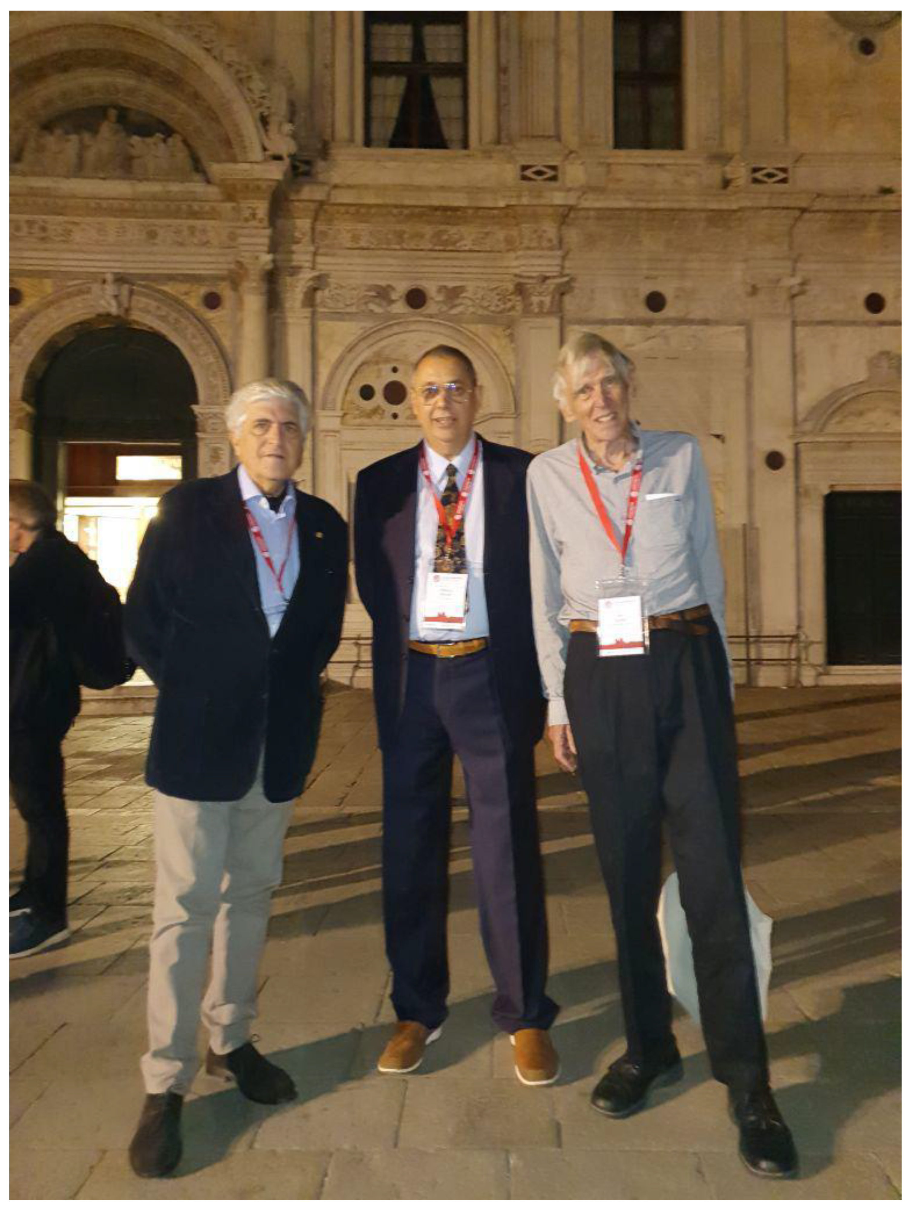
Figure A1.
Co-chairs of the “Oceans from Space III, IV and V” Symposiums: Luigi Alberotanza (left), Vittorio Barale (center), and Jim Gower (right). In the background, a partial view of the façade of the Scuola Grande di San Marco, where the fifth edition of the Symposium was held in 2022.
Figure A1.
Co-chairs of the “Oceans from Space III, IV and V” Symposiums: Luigi Alberotanza (left), Vittorio Barale (center), and Jim Gower (right). In the background, a partial view of the façade of the Scuola Grande di San Marco, where the fifth edition of the Symposium was held in 2022.

After being carefully planned and scheduled to take place at the same decadal interval, “Oceans from Space V” had to be postponed twice, first from its original date in 2020 to 2021, and then again to 2022, due to the continuing COVID-19 pandemic. When it was finally held on 24–28 October 2022, in the halls of the Scuola Grande di San Marco (the seat of the Fraternity of Saint Mark since 1260, rebuilt in 1485 after a fire, with elements of Renaissance classicism and a masterful front of Byzantine flavor), both its technical and social programs had to be somewhat downsized, in order to accommodate the reduced number of participants and health protection measures that needed to be implemented. Furthermore, the lingering effects of the COVID-19 plague and the war in eastern Europe, generated by the 2022 Russian invasion of Ukraine, again caused a number of last-minute cancellations, before as well as during the conference itself. In spite of this reduced attendance, the Symposium still attracted about 100 participants, primarily from Europe and North America, with smaller representations from South America, Africa, and Asia. The main sponsors of the event were JRC/EC and the newly established Istituto di Scienze Marine (ISMAR) of the Italian CNR, together with the ESA and European Organization for the Exploitation of Meteorological Satellites (EUMETSAT). NASA also renewed its sponsorship through a grant to the SCOR, managed by the International Ocean Colour Coordinating Group (IOCCG). The Italian Tethys Research Institute (TRI), MDPI Remote Sensing, and NSA Group, which manned the Symposium Secretariat, provided additional in-kind support. The chairmanship of the event was still provided by V. Barale, L. Alberotanza, and J. Gower. The NSA Group published the conference Proceedings [34] as a draft version prior to the conference and in their final form in 2023, again as a collection of Extended Abstracts. A number of representative contributions were selected during the conference itself for publication as full-length papers in the present “Oceans from Space V” Special Issue of the MDPI Remote Sensing journal.
Appendix B
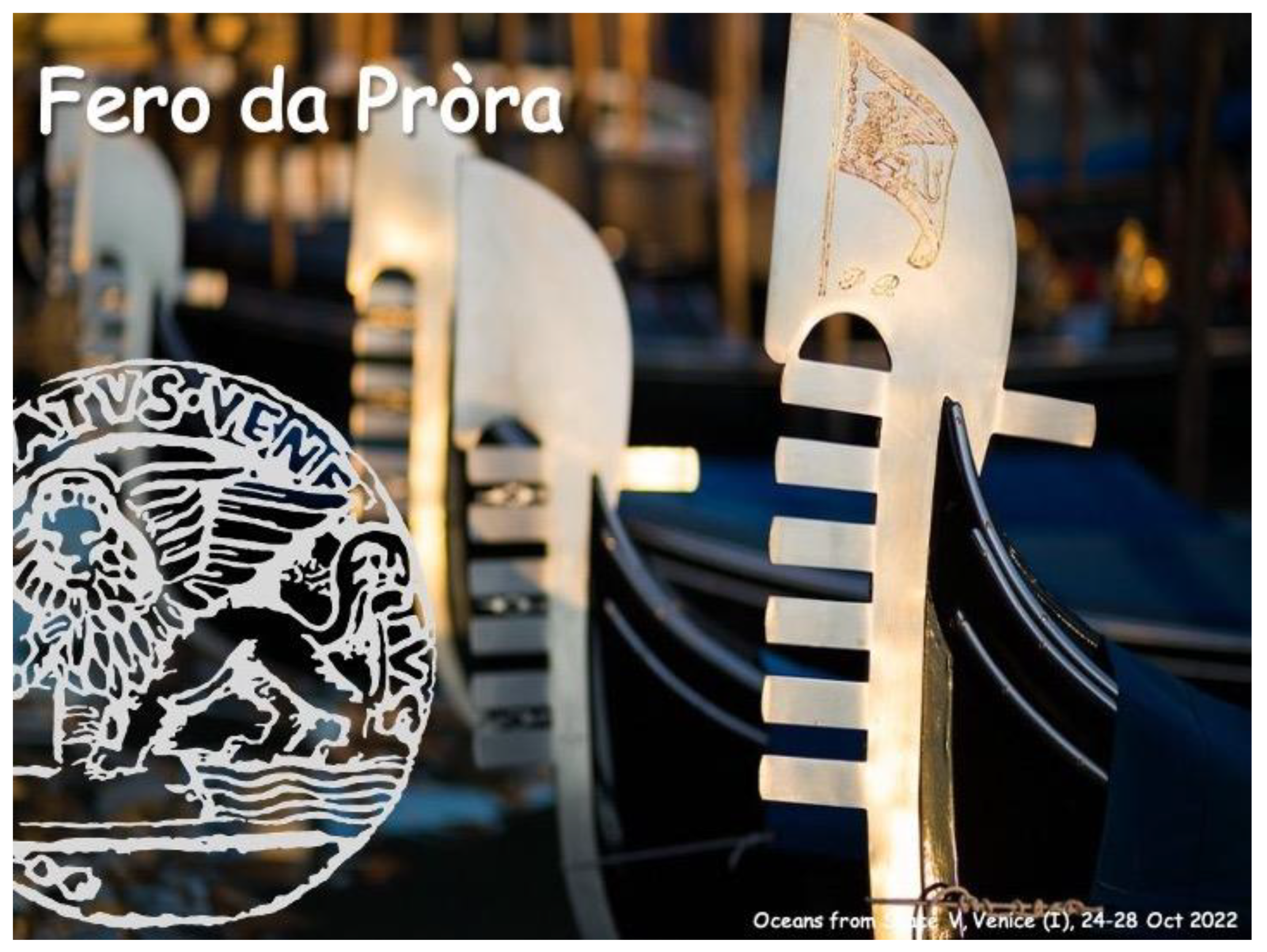
In the last three editions of the Symposium, the “Oceans from Space” Scientific Committee assigned Fero da Pròra Awards to recognize the sometimes obscure, but fundamental, work of those colleagues who, over the years, have played a major role in the satellite oceanography community (Table A1). The Fero da Pròra, or “prow iron” in Venetian dialect, seen on every gondola (see Figure A2), is a counter-weight balancing the gondoliere on the stern, thus allowing the vessel to sail smoothly with any number of passengers.

Table A1.
“Oceans from Space V” Fero da Pròra Awards.
| Year | Fero da Pròra Award Recipients | Spec. |
|---|---|---|
| 2000 | Jim Gower | |
| (Ret.) Institute for Ocean Sciences, Sidney (CAN) | ||
| 2010 | Tom Allan | In Memoriam |
| (Ret.) Satellite Observing Systems, Godalming (UK) | ||
| 2010 | Roberto Frassetto | |
| (Ret.) Consiglio Nazionale delle Ricerche, Venice (I) | ||
| 2010 | Dennis K. Clark | |
| NOAA NESDIS, Silver Spring, MD (USA) | ||
| 2010 | Ezio Balliano | For Artistic Contribution |
| Vercelli (I) | ||
| 2022 | Giuseppe Zibordi | |
| (Ret.) Joint Research Centre, EC, Ispra (I) | ||
| 2022 | Christina K. Cross & Victoria K. Cross | Youngest Participant Ever * |
| Florida Atlantic University, Fort Pierce, FL (USA) |
* High-school students C.K. Cross and V.K. Cross were co-authors of an award-winning poster.
Symposium participants of the the last three editions of the “Oceans from Space” received, in their conference kit, a ballot to be used for the evaluation of every contribution, oral or poster, on a scale from 1 (poor) to 5 (excellent), on the basis of either the presentation itself or of the Extended Abstract available in the Proceedings. After compilation of all the entries, on the last day of the Symposium, a Best Contribution Award and 10 Distinguished Contribution Awards were issued during the Closing Session. The results of this exercise for “Oceans from Space V” are shown in Table A2.
Table A2.
“Oceans from Space V” Best Contribution (BC) and Distinguished Contributions (DC).
| Author(s) & Title | ||
|---|---|---|
| 1 | M.M. Martinez *, L.A Ruiz-Etcheverry, B. Picard, M. Saraceno, and C. Guinet | BC |
| “Analysis of hydrographic data collected by Southern Elephant Seals in the Argentine Continental Shelf” | ||
| 2 | C. Gommenginger *, A. Martin, A. Egido, K. Hall, P. Martin-Iglesias, and T. Casal et al. | DC |
| “Imaging small-scale ocean dynamics at interfaces of the Earth System with the SEASTAR Earth Explorer 11 mission candidate” | ||
| 3 | P. Bontempi * | DC |
| “The value of regional and planetary ocean information for Earth’s blue economy” | ||
| 4 | C. Donlon * | DC |
| “Oceans from Space: Achievements of the European Space Agency over the last decade and plans for the next decade” | ||
| 5 | D.T. Sandwell *, J.A. Goff, J. Gevorgian, H. Harper, S.S. Kim, Y. Yu, and B. Tozer et al. | DC |
| “Global Seafloor Mapping from Ships, Satellites, and Geological Information for High Resolution Ocean Models: SYNBATH” | ||
| 6 | L. Lorenzoni * | DC |
| “Looking at the past to pave the future: NASA’s OBB perspective on priorities for aquatic ecosystems and bio-geo-chemistry” | ||
| 7 | A. Moiseev *, F. Collard, J.A. Johannessen, and B. Chapron | DC |
| “Total surface current radial velocity from Sentinel-1 SAR Doppler shift observations” | ||
| 8 | V.K. Cross, C.K. Cross *, M. McCoy, and T. Moore | DC |
| “Validation and Comparison of the HawkEye CubeSat Sensor to Current Ocean Color Satellites over AERONET-OC Sites” | ||
| 9 | G. Umgiesser * | DC |
| “Venice and Acqua Alta in the perspective of Climate Change” | ||
| 10 | K. Ruddick*, M. Beck, A. Bialek, V. Brando, A. Cattrijsse, J. Concha, A. Corizzi et al. | DC |
| “WATERHYPERNET: Automated in situ measurements of hyperspectral water reflectance for satellite validation…and more” | ||
| 11 | D. Ciani *, M-H. Rio, B. Buongiorno Nardelli, S. Guinehut, E. Charles, H. Etienne et al. | DC |
| “Ocean circulation from the synergy of altimeter and oceanic tracers observations” |
* Presenting and/or corresponding Author, who received the Contribution Award.
In line with its longstanding tradition of coupling science and art, “Oceans from Space” has promoted high-quality publishing (i.e., the photographic volume on “Venice, places and history” by D. Reato, re-published by White Star as a special edition for “Oceans from Space III”) and visual arts expressions (i.e., the painting “Le Pagine nell’Acqua” by E. Balliano, commissioned for “Oceans from Space IV”). On the occasion of “Oceans from Space V”, a poetry contest was set up among all participants. A jury composed of the conference Co-Chairs, and of other volunteers willing to evaluate the submitted entries, chose the Haiku shown in Table A3 as the best poem of the Symposium.
Table A3.
“Oceans from Space V” Poetry Contest: winning composition.
| “Oceans from Space V” Poetry Contest |
| A Whirling Haiku |
| by Phoebe Hudson |
| Turbulent mixing |
| of wind, waves and ideas. |
| Swirling discussion. |
Figure A2.
“Oceans from Space V” Closing Session slide introducing the Fero da Pròra Awards.

References
- Ewing, G.C. Oceanography from Space. In Proceedings of the Conference on the Feasibility of Conducting Oceanographic Explorations from Aircraft, Manned Orbital and Lunar Laboratories, Woods Hole, MS, USA, 24–28 August 1964; WHOI Ref. No. 65-10. Woods Hole Oceanographic Institution: Woods Hole, MS, USA, 1965. [Google Scholar]
- Kaula, W.M. The Terrestrial Environment: Solid Earth and Ocean Physics. In Report of the Williams College Conference on Solid Earth and Ocean Physics, Williamstown, MS, USA, 11–21 August 1969; NASA Contractor Report CR-1579; National Aeronautics and Space Administration: Langley, VA, USA, 1970. [Google Scholar]
- Apel, J.R. (Ed.) Sea surface topography from space. In Vols. 1 & 2. NOAA Technical Reports: ERL No. 228 and AOML No. 7; National Oceanic and Atmospheric Administration: Boulder CO, USA, 1972. [Google Scholar]
- Apel, J.R. Three Decades of Satellite Oceanography: The View from on High. In Space Remote Sensing of Subtropical Oceans, Proceedings of the COSPAR Colloquium on Space Remote Sensing of Subtropical Oceans (SRSSO), Taiwan, 12–17 September 1995; Liu, C.T., Ed.; COSPAR Colloquia Series; Pergamon: Oxford, UK, 1997; Volume 8, pp. 11–19. [Google Scholar] [CrossRef]
- Minnett, P.J.; Alvera-Azcárate, A.; Chin, T.M.; Corlett, G.K.; Gentemann, C.L.; Karagali, I.; Li, X.; Marsouin, A.; Maturi, E.; Santoleri, R.; et al. Half a century of satellite remote sensing of sea-surface temperature. Remote Sens. Environ. 2019, 233, 111366. [Google Scholar]
- Sørensen, B.M. The North Sea Ocean Color Scanner Experiment 1977, Final Report; Commission of the European Communities, Joint Research Centre & Directorate General XII: Ispra, Italy; Brussels, Belgium, 1979; p. 126. [Google Scholar]
- Robinson, I.S. Measuring the Oceans from Space. The Principles and Methods of Satellite Oceanography; Springer-Praxis Books in Geophysical Sciences; Springer: Berlin/Heidelberg, Germany; New York, NY, USA, 2004. [Google Scholar]
- Born, G.H.; Dunne, J.A.; Lame, D.B. Seasat Mission Overview. Science 1979, 204, 1405–1406. [Google Scholar] [PubMed]
- Schwalb, A. The TIROS-N/NOAA A-G Satellite Series. NOAA Technical Memorandum NESS 95; National Oceanic and Atmospheric Administratio, National Environmental Satellite Service: Washington, DC, USA, 1979; p. 75.
- Hovis, W.A.; Clark, D.K.; Anderson, F.; Austin, R.W.; Wilson, W.H.; Baker, E.T.; Ball, D.; Gordon, H.R.; Mueller, J.L.; El-Sayed, S.Z.; et al. Nimbus-7 Coastal Zone Color Scanner: System Description and Initial Imagery. Science 1980, 210, 60–63. [Google Scholar] [PubMed]
- Gower, J.F.R. (Ed.) Oceanography from Space; Marine Science; Springer: Boston, MA, USA, 1981; Volume 13. [Google Scholar] [CrossRef]
- Nelepo, B.A.; Terekhin, Y.V.; Kosnirev, V.K.; Khmirov, B.E. Sputnikovaya Hydrophysica (Satellite Hydrophysics); Nauka Publishing House: Moscow, Russia, 1983. [Google Scholar]
- Mitnik, L.M.; Victorov, S.V. (Eds.) Radiolokatsiya Poverkhnosti Zemli iz Kosmosa (Radar Sensing of the Earth’s Surface from Space); Hydrometeoizdat Publishing House: Leningrad, Russia, 1990. [Google Scholar]
- Wilson, W.S.; Fellous, J.L.; Kawamura, H.; Mitnik, L.M. A History of Oceanography from Space. In Remote Sensing of the Marine Environment; Ryerson, R.A., Ed.; Manual of Remote Sensing; American Society for Photogrammetry and Remote Sensing: Bethesda, MD, USA, 2006; Volume 6, pp. 1–31. [Google Scholar]
- McClain, C.R.; Feldman, G.C.; Hooker, S.B. An overview of the SeaWiFS project and strategies for producing a climate research quality global ocean bio-optical time series. Deep. Sea Res. 2004, 5, 5–42. [Google Scholar]
- NASA Earth Observing System. Available online: https://eospso.nasa.gov (accessed on 26 May 2023).
- ESA Earth Online. Available online: https://earth.esa.int/eogateway/missions/envisat (accessed on 26 May 2023).
- JAXA Advanced Earth Observing Satellite II “Midori II” (ADEOS-II). Available online: https://global.jaxa.jp/projects/sat/adeos2/index.html (accessed on 26 May 2023).
- Guo, Q.; Xu, X.; Zhang, K.; Li, Z.; Huang, W.; Mansaray, L.R.; Liu, W.; Wang, X.; Gao, J.; Huang, J. Assessing Global Ocean Wind Energy Resources Using Multiple Satellite Data. Remote Sens. 2018, 10, 100. [Google Scholar] [CrossRef]
- Visser, P.N.A.M. Gravity field determination with GOCE and GRACE. Adv. Space Res. 1999, 23, 771–776. [Google Scholar] [CrossRef]
- Kwok, R.; Kacimi, S.; Webster, M.A.; Kurtz, N.T.; Petty, A.A. Arctic snow depth and sea ice thickness from ICESat-2 and CryoSat-2 freeboards: A first examination. J. Geophys. Res. Ocean. 2020, 125, e2019JC016008. [Google Scholar] [CrossRef]
- International Altimetry Team. Altimetry for the future: Building on 25 years of progress. Adv. Space Res. 2021, 68, 319–363. [Google Scholar] [CrossRef]
- POLDER. Available online: https://en.wikipedia.org/wiki/POLDER (accessed on 28 May 2023).
- Oceansat. Available online: https://en.wikipedia.org/wiki/Oceansat (accessed on 16 May 2023).
- Haiyang (Satellite). Available online: https://en.wikipedia.org/wiki/Haiyang_(satellite) (accessed on 16 May 2023).
- KOSC Korean Ocean Satellite Center. Available online: https://kosc.kiost.ac.kr/index.nm?lang=en&contentId=82 (accessed on 25 May 2023).
- Vinogradova, N.; Lee, T.; Boutin, J.; Drushka, K.; Fournier, S.; Sabia, R.; Stammer, D.; Bayler, E.; Reul, N.; Gordon, A.; et al. Satellite Salinity Observing System: Recent Discoveries and the Way Forward. Front. Mar. Sci. 2019, 6, 243. [Google Scholar] [CrossRef]
- NASA. Earth Data. Visible Infrared Imaging Radiometer Suite (VIIRS). Available online: https://www.earthdata.nasa.gov/sensors/viirs (accessed on 30 May 2023).
- JAXA. Global Change Observation Mission—Climate “Shikisai” (GCOM-C). Available online: https://global.jaxa.jp/projects/sat/gcom_c/ (accessed on 30 May 2023).
- Copernicus. Europe’s Eyes on Earth. Available online: https://www.copernicus.eu/en (accessed on 30 May 2023).
- Steunou, N.; Desjonquères, J.D.; Picot, N.; Sengenes, P.; Noubel, J.; Poisson, J.C. AltiKa Altimeter: Instrument Description and In-Flight Performance. Mar. Geod. 2015, 38 (Suppl. 1), 22–42. [Google Scholar] [CrossRef]
- Hauser, D.; Dong, X.; Aouf, L.; Tison, C.; Castillan, P. Overview of the CFOSAT Mission. In Proceedings of the IEEE International Geoscience and Remote Sensing Symposium (IGARSS) Conference, Beijing, China, 10–15 July 2016. [Google Scholar]
- Fu, L.L.; Alsdorf, D.; Rodriguez, E.; Morrow, R.; Mognard, N.; Lambin, J.; Vaze, P.; Lafon, T. The SWOT (Surface Water and Ocean Topography) Mission: Spaceborne Radar Interferometry for Oceanographic and Hydrological Applications. In Proceedings of the OceanObs’09, Venice, Italy, 21–25 September 2009. [Google Scholar]
- Barale, V.; Gower, J.F.R.; Alberotanza, L. (Eds.) Proceedings “Oceans from Space V”, Venice 2022; NSA GROUP: Rome, Italy, 2022; p. 248. [Google Scholar]
- The Ocean Decade. The Science We Need for the Ocean We Want. Available online: https://oceandecade.org (accessed on 25 May 2023).
- International Science Council. Available online: https://council.science (accessed on 18 May 2023).
- Barale, V.; Gower, J.F.R.; Alberotanza, L. (Eds.) Oceans from Space, Venice 2000, Abstracts; EUR 19661 EN; Publication Office of the European Union: Luxemburg, 2010; p. 282. [Google Scholar]
- Barale, V. Special Issue Oceans from Space, Venice 2000. Int. J. Remote Sens. 2004, 25, 1255–1543. [Google Scholar]
- Barale, V.; Gower, J.F.R.; Alberotanza, L. (Eds.) Oceanography from Space, Revisited; Springer: Dordrecht, The Netherlands; Heidelberg, Germany; London, UK; New York, NY, USA, 2010; p. 374. [Google Scholar]
- Barale, V.; Gower, J.F.R.; Alberotanza, L. (Eds.) Proceedings (Extended Abstracts Collection) “Oceans from Space” Venice 2010; EUR 24324 EN; Publication Office of the European Union: Luxemburg, 2010; p. 265. [Google Scholar]
Table 1.
Ocean Observations: techniques, spectral regions, primary and derived Parameters.
| Surface Parameters | Spectral Regions | λ * | |
|---|---|---|---|
| (Passive Techniques: Spectrometers, Radiometers) | |||
| (Active Techniques: LIDARs) | |||
| 1. | REFLECTANCE *1 | Visible & Near Infrared | (a) |
| Surface Color, Optical Properties, Water Constituents, Bathymetry, Ice | |||
| Pigment(s) Concentration, Dissolved Organic Matter, Suspended Matter | |||
| Phytoplankton Biomass, Productivity, Functional Types, Macro-algae | |||
| 2. | EMISSIVITY *2 | Thermal Infrared & Microwaves | (b) |
| Sea Surface Temperature (Skin temperature, Mixed Layer Temperature) | |||
| Sea Surface Salinity | |||
| (Surface Roughness) | |||
| (Active Techniques: Imaging RADARs, Scatterometers, Altimeters) | |||
| 3. | ROUGHNESS *3 | Microwaves | (c) |
| Wave Height, Wave Spectra, Internal Waves | |||
| Wakes, Films, Slicks, Ice | |||
| Surface Winds | |||
| 4. | ELEVATION *4 | Microwaves | (c) |
| Surface Height (with respect to the Geoid), Slope | |||
| Geostrophic Currents, Eddies, Sea Level Rise | |||
| Ocean Geoid, Bathymetry | |||
* Common observation wavelengths λ are: (a) 380–750 nm and >750 nm; (b) typically 3.5–12.5 μm and 0.1–10 cm; (c) primarily 1.3–76.9 cm, band letter designation Ku to L.
*1 Measure is reflected Sunlight or return of LIDAR pulse.
*2 Measure is emitted Earth radiation.
*3 Measure is fine detail of reflected Imaging RADAR pulse, or averaged power of Scatterometer return.
*4 Measure is time, shape, and strength of nadir return, following a pulse emitted by RADAR Altimeter.
Table 2.
“Oceans from Space V” scientific and technical themes.
| No. | Themes | Sessions |
|---|---|---|
| 1 | Missions, Satellites, and Sensors | 4 |
| Technical Issues, Instruments, and Data Synergies | ||
| Novel Analyses, Sea Surface Salinity, and Acidification | ||
| Sensor Arrays, Multi-Mission/Sensor, and Cube/Small-Sats | ||
| 2 | Models, Assimilation, and Cal/Val | 2 |
| Modelling and Data Assimilation (in Global Models) | ||
| Assimilation of Model Data for New Space Products | ||
| Uncertainties, Cal/Val, and In Situ Technologies | ||
| 3 | Regional and Planetary Issues | 1 |
| Ocean Basins, Arctic Ocean, and Antarctica | ||
| Continental Waters, Marginal Basins, and Sea Level Rise | ||
| Relating Earth Oceans and Oceans on Exoplanets | ||
| 4 | Surface Processes, Coastal Issues, and Extreme Events | 3 |
| Ocean–Atmosphere Exchange and Coupled Modelling | ||
| Wind, Waves, and Total Surface Current Velocity | ||
| Global Coastal Ocean, Near-Coastal Waters, and Hazards | ||
| 5 | Bio–Geo–Chemical Issues and Pollution Processes | 1 |
| Aquatic Carbon from Space | ||
| Biodiversity and Floating Vegetation in the Global Ocean | ||
| Pollution (Plastics, Hydrocarbons, and Runoff) and Debris | ||
| 6 | Society, Policy, and Economics | 1 |
| Science and Society, and Management and Policy | ||
| Coastal and Marine Ecosystem Services, and Economics | ||
| Emerging Countries and Early Career Researchers | ||
| (a) | “Venice Syndrome” (Coastal Areas at Risk) | 2 |
| (b) | COVID-19 Pandemic: Oceans’ Responses | 1/3 * |
| (c) | Coupling Space Science and Citizen Science | 1/3 * |
| (d) | UN Decade of Ocean Science (2021–2030) | 1/3 * |
* Themes b, c, and d were all covered during the Symposium’s Closing Session.
Disclaimer/Publisher’s Note: The statements, opinions and data contained in all publications are solely those of the individual author(s) and contributor(s) and not of MDPI and/or the editor(s). MDPI and/or the editor(s) disclaim responsibility for any injury to people or property resulting from any ideas, methods, instructions or products referred to in the content. |
© 2023 by the author. Licensee MDPI, Basel, Switzerland. This article is an open access article distributed under the terms and conditions of the Creative Commons Attribution (CC BY) license (https://creativecommons.org/licenses/by/4.0/).
Share and Cite
MDPI and ACS Style
Barale, V. Half a Century of Oceans from Space: Features and Futures. Remote Sens. 2023, 15, 4064. https://doi.org/10.3390/rs15164064
AMA Style
Barale V. Half a Century of Oceans from Space: Features and Futures. Remote Sensing. 2023; 15(16):4064. https://doi.org/10.3390/rs15164064
Chicago/Turabian StyleBarale, Vittorio. 2023. "Half a Century of Oceans from Space: Features and Futures" Remote Sensing 15, no. 16: 4064. https://doi.org/10.3390/rs15164064
Note that from the first issue of 2016, this journal uses article numbers instead of page numbers. See further details here.