Review

Satellite Altimetry for Ocean and Coastal Applications: A Review

by
Margaret Srinivasan
* and
Vardis Tsontos
Jet Propulsion Laboratory, California Institute of Technology, Pasadena, CA 91109, USA
*
Author to whom correspondence should be addressed.
Remote Sens. 2023, 15(16), 3939; https://doi.org/10.3390/rs15163939
Submission received: 1 June 2023 / Revised: 2 August 2023 / Accepted: 4 August 2023 / Published: 9 August 2023
(This article belongs to the Special Issue Oceans from Space V)

Abstract

:
More than 30 years of observations from an international suite of satellite altimeter missions continue to provide key data enabling research discoveries and a broad spectrum of operational and user-driven applications. These missions were designed to advance technologies and to answer scientific questions about ocean circulation, ocean heat content, and the impact of climate change on these Earth systems. They are also a valuable resource for the operational needs of oceanographic and weather forecasting agencies that provide information to shipping and fishing vessels and offshore operations for route optimization and safety, as well as for other decision makers in coastal, water resources, and disaster management fields. This time series of precise measurements of ocean surface topography (OST)—the “hills and valleys” of the ocean surface—reveals changes in ocean dynamic topography, tracks sea level variations at global to regional scales, and provides key information about ocean trends reflecting climate change in our warming world. Advancing technologies in new satellite systems allows measurements at higher spatial resolution ever closer to coastlines, where the impacts of storms, waves, and sea level rise on coastal communities and infrastructure are manifest. We review some collaborative efforts of international space agencies, including NASA, CNES, NOAA, ESA, and EUMETSAT, which have contributed to a collection of use cases of satellite altimetry in operational and decision-support contexts. The extended time series of ocean surface topography measurements obtained from these satellite altimeter missions, along with advances in satellite technology that have allowed for higher resolution measurements nearer to coasts, has enabled a range of such applications. The resulting body of knowledge and data enables better assessments of storms, waves, and sea level rise impacts on coastal communities and infrastructure amongst other key contributions for societal benefit. Although not exhaustive, this review provides a broad overview with specific examples of the important role of satellite altimetry in ocean and coastal applications, thus justifying the significant resource contributions made by international space agencies in the development of these missions.

1. Introduction

For nearly 30 years, a series of satellite altimeter missions, led by the National Aeronautics and Space Administration (NASA) and its partners at the French space agency, Centre National d’Etudes Spatial (CNES), have measured ocean surface topography—the “hills and valleys” of the ocean surface influenced by gravity, ocean currents, heat content, and other dynamic geostrophic forces—to produce a continuous time series of data. Along the way, other national and international partners, including the National Oceanographic and Atmospheric Administration (NOAA), the European Space Agency (ESA), and the European Organisation for the Exploitation of Meteorological Satellites (EUMETSAT), have joined the missions. These and other partnering organizations continue to make important contributions to the missions that strengthen and enhance the science and operational returns of the significant investments made in these satellite systems. With scheduled launches through 2025, and future missions planned in the next decade, the benefit to research fields and to applications for the societal benefit of these continued missions and partnerships can be expected to grow.
Future missions in development, with advancing technologic capabilities, will extend the continuous record of consistent and calibrated data into the future. Applications for societal benefit that leverage these valuable, long-term datasets continue to expand beyond the science objectives that drove the initial development of the missions. An effort is underway by NASA and its partners to advance awareness of the utility of satellite data assets and to grow the user community. The benefits to applications from these altimetry mission data and information products include weather prediction, coastal impact (storm surges and coastal currents) assessments, fisheries management, marine transport, and disaster risk management related to sea level change and flooding (both coastal and inland), among many others. Identifying existing and potential uses of the data in operational, scientific, and other realms validates the significant resources dedicated by international space agencies to these missions. As the impacts of climate change continue to affect coastal regions around the world, the importance of satellite altimetry and its user communities can only be expected to increase.
This paper will communicate and illustrate the value of these missions to decision makers and scientific and operational organizations. We provide historical background on a joint U.S. and European satellite mission series primarily utilizing altimetry measurement systems for ocean and land surface water body targets, describing the impetus of these missions in the larger space agency exploration and technology development context. We then focus on the user communities and specific operational and non-research “applications”—that is, the utilization of the data in various operational and/or practical modalities—to illustrate the broad use categories and specific examples of these applications. We conclude with a view to potential contributions of the extended altimeter and new technologies missions planned.

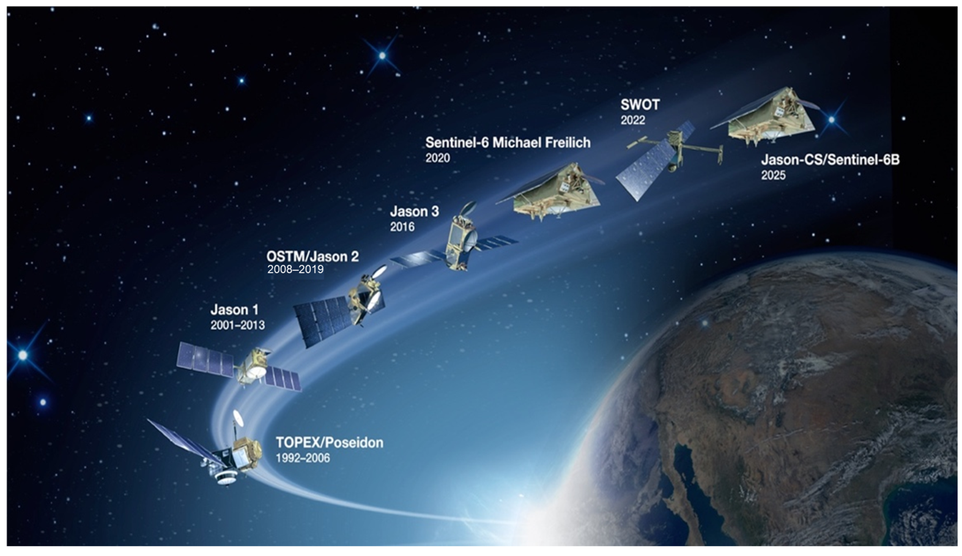
2. A Legacy of Ocean Altimetry Missions

The heritage of missions building this long-term record of data began with the launch of the flagship TOPEX/Poseidon in 1992. Jason-1 followed in 2001, with Jason-2 launching in 2008. Between three and five years of overlap in the satellite operational lifetimes of these missions provided for continuity and validation of the data record. Jason-3 launched in 2016 and remains operational. Sentinel-6 Michael Freilich (S6MF) launched in 2020 and is now the reference mission for the Jason series of satellite altimetry missions. Launched in December 2022, the Surface Water and Ocean Topography (SWOT) satellite contains advanced technologies designed to provide significantly higher resolution observations. The next satellite in this series, Jason-CS/Sentinel-6B, is planned for launch in 2025 with NASA, NOAA, ESA, EUMETSAT, and CNES continuing their partnership (Figure 1).
The measurement method of radar altimetry involves two geometric measurements: (1) the distance between the satellite and the sea surface as determined by the round-trip travel time of a microwave pulse emitted downward from the radar and reflected back to the spacecraft from the ocean and (2) multiple independent tracking systems precisely computing the satellite’s location relative to a fixed coordinate system on Earth. The resulting data yield highly accurate measurements of sea surface topography relative to a reference ellipsoid. Sophisticated instrumentation, processing, and modeling systems, along with complex data assimilation techniques, are required to produce validated data products [1].
In addition to sea surface height (SSH), these missions also provide surface height data on large lakes and rivers that fall under the satellite ground tracks, as well as significant wave height, surface wind speed, and some sea ice height and thickness information. More information on these missions, including links to mission partner websites, can be found at sealevel.jpl.nasa.gov (accessed on 3 August 2023).
S6MF ensures the continuity of sea level observations by providing ongoing measurements of global sea level rise—a key indicator of climate change. It also supports operational oceanography by improving forecasts of ocean currents, as well as wind and wave conditions. Due to the nature of the nadir altimeters on the heritage satellite missions, data in coastal regions have been limited to approximately 40 km from the coast [2]. With new digital altimeter technology and dedicated onboard processing, more precise measurements of SSH are possible. The dual frequency (C- and Ku-band) Poseidon-4 nadir radar altimeter on this satellite uses an interleaved mode to improve performance compared to the heritage instruments. The special processing of data from this instrument (unfocused synthetic aperture radar processing) will provide information on coastal ocean dynamics (coastal currents, for example) within a few kilometers of the coast.
The recently launched SWOT mission contains an exciting new technology—a Ka-band radar interferometer (KaRIn)—that will collect data across a 120 km wide swath, with a gap in the center for a nadir altimeter track. The nadir altimeter will continue the data record from the Jason series satellites. Globally, measurements will be taken both over the ocean and freshwater areas. SWOT will resolve lakes that are at least 250 m × 250 m in size, rivers 100 m wide and larger, and ocean features in the sub-mesoscale (10–100 km in extent). Improvements in resolution with SWOT will allow researchers and application user communities to monitor changes in land surface hydrology between 78 degrees north and south latitudes at unprecedented levels of detail—up to 10 times higher than the current 25 km multi-mission nadir-altimeter-based ocean data products (Figure 2). SWOT will provide the first measurements of both of these parameters with a single satellite mission.

3. From Research to Applications

Satellite missions are generally conceived of and funded with research and/or technology development objectives as a focus. They are designed to advance technologies and to address scientific questions related to ocean circulation, ocean heat potential, tides, and climate change and to advance and improve models in these and other areas. They can also be used to address operational needs of oceanographic and meteorological institutions that provide information to a wide variety of user communities, such as fishing and shipping fleets who can use it to optimize routes and operations, and for disaster management.
Global sea level rise exemplifies and is one of the more obvious and impactful consequences of climate change in the ocean. Coastal communities worldwide are already experiencing significant effects from both event-driven ocean inundation (i.e., storms at sea), as well as from high tide flooding or “sunny day” flooding where average sea levels in low-lying regions are simply more prone to flooding as sea levels continue to rise. Impacts to coastal regions from climate-driven increases in the frequency of storms and associated storm surges are exacerbated by rising sea levels and have a real cost to coastal communities [3]. Neumann et al. [4] estimated that coastal infrastructure adaptation costs for shoreline protection and nourishment along the continental U.S. coastline could reach as high as $254 billion through 2100. Community resilience planning to address these increasing threats may be improved by access to better data and models of coastal ocean dynamics, the development of which is heavily reliant on satellite remote sensing [5,6].
Before the launch of TOPEX/Poseidon, tide gauges were the only reliable mechanism for measuring trends in global sea levels. Although the tide gauge record over the last century is not definitive (due to poor spatial sampling, sensitivity to land motion and coastal effects, and other factors), some studies suggest a rate of 1.5 mm per year over this period, indicating a global average sea level rise of 15 cm (6 in) in the 20th century [7]. The satellite record (Figure 3) is now observing up to 4 mm (0.16 in) per year, resulting in nearly a 10 cm (4 in) rise since 1992 alone.
The implications of this dramatic increase in both the absolute rise and the rate of rise in sea level on coastal communities can be significant, particularly in developing countries where the adaptive capacity is more limited [8,9]. Some factors are outlined below:
  • Increased flooding: Rising sea levels exacerbate the risk of coastal flooding, making low-lying areas more vulnerable to storm surges and high tides. This puts coastal properties, infrastructure, and human lives at greater risk [9].
  • Coastal erosion: Rising sea levels contribute to the loss of beaches, dunes, and coastal ecosystems from erosion. This can impact ecosystem health, tourism, and recreational activities, as well as the beauty and economic viability of coastal regions [10,11].
  • Infrastructure vulnerability: Critical infrastructure such as roads, bridges, ports, and other utilities in coastal regions are at higher risk from rising sea levels. These assets may require costly upgrades, relocation, or protection measures to mitigate impacts and ensure long-term functionality [8,12].
  • Displacement and relocation: More coastal and island communities will face the daunting task of relocation due to increased flooding and the loss of habitable land as sea levels rise. Displaced populations face challenges in finding alternative housing, as well as potential social and economic disruptions [12].
  • Environmental impacts: Coastal ecosystems (i.e., wetlands and estuaries) are critical habitats for numerous species and provide valuable ecosystem services. Threats from sea level rise include habitat loss, altered biodiversity, and possible cascading effects on marine and terrestrial ecosystems [13].
  • Socioeconomic consequences: Coastal communities are often centers of economic activity (tourism, fisheries, and commerce) that can be disrupted, leading to financial loss, job reduction, and decreased property value. Strain on local civic budgets can result from the need for investment in adaptation measures and disaster recovery [11,14].
Addressing these issues requires comprehensive strategies that include coastal planning, adaptation and mitigation measures, and sustainable development practices [15,16,17]. Collaboration between governments, communities, and stakeholders is crucial to effectively manage the challenges posed by accelerating sea level rise [9,18]. And, importantly, informing and educating people in these communities on the connection of these impacts to long-term climate change drivers may promote better governance and more thoughtful personal and civic choices and foster a sense of collective responsibility in addressing the underlying causes of sea level rise and climate change [19].

4. User Communities

Traditional satellite altimeter missions offer valuable information on water heights over the ocean and over large lakes, reservoirs, and rivers. The new technology and higher resolution measurements from SWOT will greatly expand the number of surface water bodies that can be viewed and monitored [20], as well as vastly improve the resolution of ocean circulation features [21]. The data can be used to assess and monitor sea level change and the coastal impacts that result but can only be truly impactful if they reach and are successfully utilized by relevant user communities. NASA and its partners recognize the importance of engaging and supporting both (1) communities of practice—those who already possess capacities for using remote sensing data and, in particular, altimetry data— and (2) communities of potential—those who could benefit from the use of satellite altimetry data but are unaware of, or lack the knowledge, technical skill, or other resources to best leverage, these observations. Investment in outreach, training, educational resources, and tools to support analysis and interpretation of these data is of utmost importance in a successful data user engagement strategy.
NASA and its partners can help to inform communities about challenges such as sea level rise, coastal flooding, and other impacts related to climate change and natural processes affecting regional coastal communities globally. One key approach is the continual measurement of water heights over the ocean and large lakes and rivers. With the launch of SWOT, monitoring of dynamic ocean topography features and an even greater number of lakes and reservoirs at significantly finer scale will be possible.
The user communities for these satellite missions include oceanographers, climatologists, coastal managers, private sector organizations, and decision makers at various levels of government. These groups can make informed decisions related to climate change adaptation and mitigation, such as identifying coastal areas at risk from sea level rise (both directly from wave action and indirectly from saltwater intrusion into coastal groundwater aquifers) and planning coastal infrastructure projects, including those designed to protect coastal communities. A key component of outreach to data users is encouraging the use of data and information products from these missions via active engagement and by supporting and training individuals and organizations in the existing and potential altimetry data user communities.
S6MF is continuing to chart the rise of sea level more precisely than previously possible, allowing researchers to understand how climate change is reshaping coastlines and the accelerating rate at which this is occurring. As more than 600 million people live in coastal areas that are lower than 10 m above sea level—a number projected to rise to one billion people by 2060 [22]—and given that many coastal regions include facilities and infrastructure critical to commerce, recreation, military installations, and transportation, understanding the impacts and trends of sea level rise will allow improved assessments of threats to vulnerable coastal regions.
Impacts from Hurricane Sandy in 2012, described as one of the most damaging hurricanes ever to make landfall in the U.S., and Hurricane Harvey in 2017, which caused $125 billion in damage (second only to Hurricane Katrina, 2005, in cost) were exacerbated by intensified storms coupled with sea level rise. Recent examples of high tide flooding along the Atlantic coast of the United States in November 2021 [23] illustrate a troubling trend that is increasingly common due to a higher relative sea level in many coastal communities. This “nuisance flooding” is expected to increase in frequency over the coming decades, according to the NOAA report “State of High Tide Flooding and Annual Outlook” [24]. For U.S. coastal communities, high tide flooding events are likely to reach 7–15 days by 2030 and 25–27 days by 2050 [25].
The data collected from satellite altimeter missions have tremendous potential to inform decision making and improve the quality of life for people around the world. Measuring water surface topography over the globe enables a wide range of practical applications with tangible benefits to society. These include planning for the impacts of sea level rise on coastal communities as discussed above, supporting operational oceanography and safety at sea, improved flood modeling, transboundary water information sharing, weather and climate forecasting, water resources management, and decision support, among others.
In 2014, a U.S. presidential executive order established the National Plan for Civil Earth Observations (the National Plan) to promote the use of observing system data and information products in 12 identified societal benefit areas [26]. Altimetry data may be useful in informing at least half of these. The use of altimetry data contributes to the following societal benefit areas of the National Plan:
  • Biodiversity—understanding and conservation of biodiversity, fisheries management, and marine protected areas.
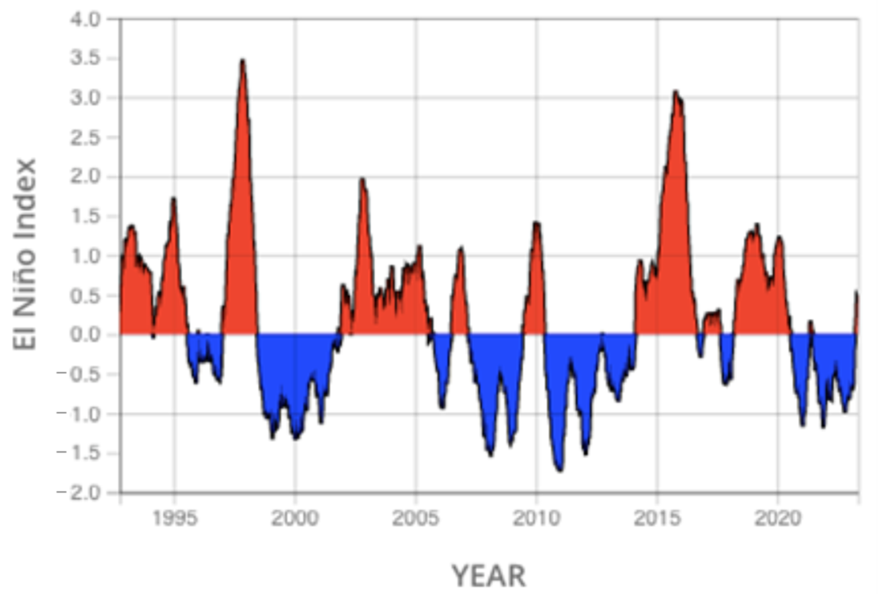
  • Climate—understanding and assessment of sea level rise and global ocean heat content using climate records from altimetry.
  • Disasters (hazards)—storm surge from coastal storms, hurricane intensity forecasts, and improved tsunami wave models.
  • Ocean and coastal resources—storm surge modeling, sediment transport, and water quality.
  • Water resources—climate-related impacts to the Earth’s water cycle and resources.
  • Weather—seasonal forecasts of the numbers and strengths of hurricanes expected in a given hurricane season, as well as intensity forecasts of individual hurricanes.

5. Applications Areas

Select applications relevant to coastal and ocean management issues are highlighted below, with some examples of user communities already engaged in the use of the data.

5.1. Operational Oceanography—Simultaneous Operation of Multiple Missions for Operations

Unique capabilities for ocean operations are enabled by the long data record and the development of data merging techniques. Operational oceanography is a critical application of satellite altimetry missions and provides essential support to a range of maritime operations. Near-real-time, high-resolution global sea level data products and maps are routinely produced by CNES via a multi-mission production system [27]. Figure 4 illustrates an example of this operational data system, called SSALTO/DUACS (the CNES/CLS multi-mission ground system/operational data system). These near-real-time, high-resolution global sea level anomaly maps from the simultaneous operation of multiple missions are routinely produced and distributed publicly via the CMEMS data portal as part of the European Copernicus Program (marine.copernicus.eu, accessed on 3 August 2023). The system provides real-time information about ocean currents, sea surface temperature, and other important variables and can, thus, help to improve maritime safety and support search and rescue operations. In addition, the data can be used to improve weather and climate forecasting, which is critical for agriculture, transportation, and other industries that are heavily dependent on accurate weather predictions both in coastal and inland zones.
The SSALTO/DUACS system also allows for the development of unique capabilities that can help address operational challenges in marine sectors. The generated maps are routinely assimilated in ocean models and used in setting initial and boundary conditions. The resulting forecasts of ocean state are then utilized to forecast conditions for maritime operations, including the optimization of shipping routes, the assessment of sea state for risk to offshore infrastructure, and oil spill tracking.

5.2. Fisheries Management and Biodiversity—Tracking Marine Life

Over the past two decades, there has been a proliferation in the use of remote sensing data in a range of marine ecological management applications focusing especially on fisheries [28,29,30,31,32,33,34], aquaculture [35], biodiversity conservation and marine protected areas [36,37,38], coastal ecosystem monitoring, and marine spatial planning [6,39]. Fisheries and biodiversity applications in particular have involved the integration of key ocean variables from a series of multi-sensor satellite measurements with biological data to (1) characterize species habitat suitability and preferences based on observed distributions and environmental variable value ranges [40,41,42,43,44,45]; (2) quantify relationships between environmental factors and spatiotemporal variability in species abundance distributions [46,47,48,49,50,51,52,53]; and (3) identify species associations with dynamic mesoscale oceanographic features that serve as hotspots of enrichment and biological productivity that are the target of commercial fishing activity [54,55,56]. The latter includes eddies [57,58,59], Lagrangian fronts [32,60], geostrophic currents [61,62,63], and convergence and upwelling zones [64,65,66].
Such applications have been enabled by the increased availability of an extensive series of global ocean surface topography measurements that are the consequence of continuity in satellite altimetry missions conducted by multiple agencies over 30 years. These include data on sea surface height anomaly (SSH-A), geostrophic current velocity, eddy kinetic energy, and derived products on Lagrangian fronts, filaments, and gradients that are applied synergistically with complementary satellite observations on sea surface temperature, chlorophyll-A concentration, surface wind velocity and curl, and satellite surface salinity. The extent of the coverage of this suite of remotely sensed essential ocean variables has facilitated fishery applications spanning the world’s oceans basins, including multiple regions of the Pacific [45,47,67,68,69], Atlantic [59,64,70], and Indian Oceans [41,71]; the Southern Ocean [61,72]; inland seas such as the Mediterranean sea [57,62,73] and the Arabian Sea [48]; and the Gulfs of Mexico [50] and California [74]. They involve the integration of remote sensing environmental observations with in situ biological data of different kinds, including predominantly fishery-dependent species catch; fishing effort; derived indices of relative population abundance (catch per unit effort—CPUE); systematic scientific surveys undertaken predominantly for early life history and recruitment studies of larval ichthyoplankton stages; electronic satellite tagging data of individual animal movements [51,67,68,75]; automatic identification system (AIS) and vessel monitoring system (VMS) data on fishing fleet dynamics [52,76]; and even fish population genetic information [74]. Analyses of collocated satellite environmental and in situ biological data for fisheries and other ecological applications predominantly involve the use of statistical modeling techniques, such as general additive models (GAM); Bayesian approaches, non-linear time series, non-parametric approaches, multivariate methods, the computation of synoptic habitat suitability indices (HSI), and the application of GIS tools [49,70].
Fishery applications involve the use of satellite altimetry data that span a wide range of biological taxa and include both target and incidental bycatch species. They range principally from highly migratory large pelagic fish species such as tunas [41,42,46,53,77] and swordfish [45,70] to small pelagics like sardine [47,57], mackerel, [44,45], and saury [60], in addition to invertebrate species of commercial importance such as squid [40,43,78] and lobster [79,80]. Habitat analyses of by-catch species at risk and the degree of their population overlap with capture fisheries have included elasmobranch species [38,51,75], marine turtles [67,68], marine mammals [59,81], albatross, and petrel bird species [72]. Multivariate remote sensing data, often in conjunction with regional ocean and coastal circulation models that assimilate altimetry, have also been applied for some demersal species such as rockfish, cod, and walleye pollock to examine larval transport, reproductive subsidy, and recruitment from spawning areas and thus the extent of coupling between spatially extended metapopulations in relation to the location of marine protected areas [61,63,74,82,83].
Successful operational uses of altimetry in conjunction with data from other satellite sensors in fisheries and ecological conservation applications include the routine provisioning of potential fishing zone (PFZ) advisories and map products indicating by-catch risk likelihood for both target species and those protected or vulnerable to incidental capture in a given fishery. Such forecasts are based on the availability of near-real-time satellite data and empirical quantitative relationships between species abundance distributions and remotely sensed environmental variable ranges and mesoscale oceanographic features, such as eddies and fronts. PFZs have been developed for both offshore and coastal fisheries in several regions and have shown to be effective in directing fishing effort to areas with higher resource concentrations, thus maximizing the efficiency and revenue of fishing operations by reducing fuel costs [31,40,69,84,85,86,87]. PFZ advisories for the Bay of Bengal and Andaman Sea indicating the locations of eddies from sea level anomaly data were shown by experimental fishing to significantly increase catch rates within eddies relative to traditional control fishing areas [58]. Similar approaches have been used to mitigate by-catch and have involved the use of remote sensing data to help minimize the overlap of fishery operations with likely times and areas of aggregation of protected species. The NOAA TurtleWatch product [67], focused on the North Pacific subtropical frontal zone, is an example that has been successfully adopted and applied to reduce Hawaii’s longline fishery interactions with protected loggerhead turtle populations in that region. NOAA’s WhaleWatch [88] and EcoCast [89] tools are successful examples of a more generalized framework developed for the California Current ecosystem that routinely make available remote sensing data and habitat distribution model results to reduce the by-catch of several pelagic species, including sharks, turtles, seals, and whales.
The breadth and growing extent of applications discussed indicate that remote sensing more generally has an important role to play in supporting emerging ecosystem-based fisheries management and dynamic ocean management frameworks that explicitly incorporate information on environmental variability. The potential utility of satellite ocean surface topography data in this application space is expected to increase further with new missions providing observations at unprecedented spatial resolution. Future data from the SWOT mission, launched in December 2022, will enable the detection and tracking of sub-mesoscale features, providing unique insights on the spatial dynamics of marine populations in relation to their environment that will further enable ecological assessment and management applications.

5.3. Weather and Climate Forecasting—Improved Accuracy

Data from altimetry missions have proved to be a critical component of global climate studies and key to understanding the Earth’s delicate climate balance. They provide information and insight on short-term climate events such as the El Niño and La Niña phases of the El Niño Southern Oscillation (ENSO), as well as longer-term climate events such as the Pacific Decadal Oscillation (PDO). Figure 5 illustrates the ENSO cycle pattern from the altimeter era. Altimeter data products are used by hundreds of researchers and operational users around the world to monitor ocean circulation and improve our understanding of the role of the ocean in climate and weather [90]. Initial and boundary conditions derived from the state of the ocean surface and the hydrologic conditions of catchment areas are used in numerical models to improve the quality of weather and climate forecasting. SWOT will enable more accurate weather and climate forecasting, especially seasonally.
Satellite altimetry missions are vital for the monitoring and forecasting of extreme weather events such as tropical cyclones and hurricanes. Near-real-time data from these missions are used to produce sea level anomaly maps, which can provide critical information for forecasting storm surges and predicting the impact of these events on coastal communities [91]. These data are used to assess and monitor the impacts of severe weather events such as hurricanes and floods and to provide critical information that can support emergency response efforts. Altimetry data are routinely assimilated into weather models to forecast ENSO events, as well as at the National Hurricane Center to forecast hurricane intensity [92]. Global water resource impacts from climate change can be measured and modeled with decades-long climate data records from nadir altimeter missions.

5.4. Improved Flood Modeling—Coastal Flooding from Upstream and Downstream

The satellite radar altimeter record demonstrates the ability to observe water level variations of lakes, rivers, and floodplains on land, including in coastal regions. River discharge from these regions to and across the coastline can be estimated from a combination of satellite estimates of rainfall and hydrologic modeling [93]. Subsequent interactions with river delta and estuary systems, which contain complex hydrologic regimes resulting from upstream flow and downstream tidal influences, can also be assessed. Combining satellite altimetry in data assimilation frameworks can improve predictive abilities of models to help assess flood hydraulics and the risk and impacts to coastal regions from upstream and downstream conditions [94]. Reprocessing Jason-1 and Jason-2 data has provided a gridded sea level anomaly data set close to the coast (within 20 km) to better assess coastal impacts of sea level change [95]. SWOT will bring the data to within a few kilometers of the coast. Nuisance flooding, flooding from land, and coastal erosion during extreme events can be assessed using these tools and can provide valuable information for coastal planners. These methods can be made more effective by combining satellite with in situ data and models to improve forecasts.
Satellite remote sensing also provides indirect measurements to predict or forecast river discharge. When information about upstream water levels is available, the accuracy of flood potential on downstream river reaches can be better assessed. Hossain et al. [93] describe a system developed for the Flood Forecasting and Warning Center (FFWC; http://www.ffwc.gov.bd, accessed on 3 August 2023) of the Bangladesh government to use satellite altimetry as “virtual” gauging stations that can supplement in situ gauging capacity. Data from the Jason series satellites was used to demonstrate a higher sampling of data from upstream locations to improve the accuracy of river levels downstream.
As sea levels continue to rise and the frequency of coastal flooding increases, the use of satellite altimetry data is becoming increasingly important to understand the impacts and trends that will affect coastal regions. By engaging with user communities, NASA and its partners can ensure that the benefits of satellite altimetry are realized by a wide range of stakeholders, including those in coastal communities, who are particularly vulnerable to the impacts of climate change.

5.5. Hazards—Floods and Insurance

In addition to improvements in flood modeling, assessments of real or potential property damage and economic losses from floods and coastal impacts of sea level rise can be mitigated when hazards are better anticipated. Risk assessment methods used by property insurers can be informed by satellite remote sensing. Satellite altimetry data can be used to assess flood risk and determine insurance premiums for properties located in flood-prone areas, for example. Insurance companies can gather information about the elevation of the land and coastal and inland water levels to identify potential flood zones.
Several scientific studies have explored the role of satellite altimetry in decision support for coastal hazards and change. For example, a study by Woodworth et al. [96] used satellite altimeter data to investigate global and regional sea level changes and their implications for coastal flooding. Cazenave and Llovel [97] explored the role of satellite altimetry in the measurement of global sea level rise and its implications for coastal hazards and change. These changes include the impact of human activity on deltaic systems, including dam and reservoir construction and river diversion for agriculture. These activities upset the natural equilibrium of many deltas, exacerbating impacts from sea level rise, among other complications. Similarly, the International Altimetry Team [98] highlighted the importance of satellite altimetry data in supporting decision making for coastal hazards and change, including the identification of areas at risk from sea level rise and the development of adaptive management strategies.
Hurricanes and typhoons represent many challenges to coastal communities including extreme winds, rain, storm surges, and flooding. These, typically tropical, storms form over warm water and are the most powerful storms on Earth. Forecasting the impact of these events can save lives and mitigate losses to property in coastal regions by providing accurate predictions of storm structure and storm-induced surface waves. The societal impact of hurricanes is strongly related to the strength of the storm measured in “categories” from 1 (with sustained winds between 74–95 miles per hour) to 5 (sustained winds of 157 mph or greater). Higher-category storms have a greater potential to cause significant damage to property and infrastructure and to threaten lives and public safety.
OST data are used for both seasonal forecasts of the numbers and strengths of hurricanes expected during a hurricane season and for forecasts of the strength of individual hurricanes. When hurricanes pass over warm ocean features, they can strengthen. Altimetry data are routinely used by the U.S. NOAA National Hurricane Center to improve hurricane intensity forecasts. A NOAA research area that assesses tropical cyclone heat potential (TCHP) shows that storms and hurricanes can intensify when they travel over warm ocean features (Figure 6) [99].
Researchers studying Hurricane Ike (2008) and Superstorm Sandy (2012) compared an atmosphere–wave–ocean model to Jason-1 and OSTM/Jason-2 satellite data and were able to determine the processes that influence hurricane-generated surface waves near the coast. This provided information about changes in ocean waves with water depth, directional changes in waves as they were deflected off the bottom, and changes in wind fetch (the distance over which wind has blown unobstructed) over land. The information could then be used to predict ocean surface waves at landfall three to five days in advance of a storm hitting the coast, thus providing a valuable storm surge forecast tool [100].

5.6. Additional Applications

In addition to the coastal and ocean practical and operational applications described, there are several important research applications of satellite altimetry data that have operationalization potential.

5.6.1. Tsunami Detection

Satellite altimeter data can support tsunami detection and tracking as they provide valuable information about sea surface height [101]. By continuously monitoring the ocean surface, satellite altimeters can detect and measure anomalies in sea level caused by underwater earthquakes and landslides, volcanic eruptions, or other seismic events that may trigger a tsunami [102]. Altimetry data can be used by scientists and meteorologists to assess the size and energy of tsunami-triggered ocean surface disturbances when the spacecraft ground track coincides with an event. The tsunami propagation can be modeled and combined with other data (i.e., seismographic data and ocean buoys) to provide coastal authorities an opportunity to issue timely and accurate warnings [103]. Despite limitations due to spatial and temporal sampling, it has been found that satellite altimetry could be used to directly detect tsunamis in the open ocean and to improve model predictions [104]. Given higher spatial and temporal resolution from their combined measurements, the S6MF, Jason 6B and C, and SWOT missions may be able to further improve on the current state of tsunami detection.

5.6.2. Geodetic Applications

High-precision sea surface height measurements from satellite altimetry combined with satellite-derived gravity data contribute to ocean geodetic studies and mapping the ocean floor. By combining altimetry data with other satellite-based positioning systems (i.e., GPS), marine navigation can be optimized to avoid hazards such as shallow waters or underwater obstacles [105]. Additionally, ocean circulation is influenced by ocean bottom topography [106]. Coastal bathymetry influences currents and other near-shore processes, including erosion, sediment, and even larval transport. Such information is thus integral to marine spatial planning and the management of coastal zones (see Section 5.2).

5.7. Decision Support—Reducing Environmental Risk and Contributing to Public Policymaking

Decision support is a vital application of satellite altimeter data, with the potential to reduce environmental risk and contribute to public policymaking. With the inevitable effects of climate change such as altered weather patterns and rising sea level, coastal and inland environments, infrastructure, and ecosystems are expected to be significantly impacted. Predictions of a steady increase in sea level rise and storm frequency and intensity [107], coupled with changes in land use and population increases, pose significant planning challenges for coastal communities. While significant resources have been directed to predicting the potential consequences of climate change, emphasis is required to develop rational approaches to guide decision making under uncertainty. There is also a need to develop and assess alternative adaptive strategies to manage coastal hazards and change. The use of measurements from land hydrological systems and from ocean data closer to the coasts, combined with in situ and other remote sensing assets, can support the development of data and information products that meet evolving user requirements [98].
Satellite altimetry data can provide an essential foundation for effective coastal management. The data can be particularly useful in supporting decision making related to coastal issues. By providing accurate information about sea level rise and coastal flooding, these data can help to support coastal planning and infrastructure development [108]. For example, the data can be used to identify areas that are most at risk of flooding and to develop strategies for protecting critical infrastructure such as ports, airports, and power plants. They can be used to facilitate the development of early warning systems for coastal hazards such as storm surges and flooding, which can help to save lives and minimize economic losses. Using the data to monitor changes in sea level and combining that information with coastal erosion over time can provide critical information for long-term planning and adaptation strategies. User communities, including coastal planners, emergency management officials, and infrastructure developers, among others, can benefit greatly from these data for use in their management activities.

6. Conclusions

Continuity in satellite altimetry missions via partnerships among international space agencies for over three decades has been instrumental to the development of an essential climate data record on aspects of land and ocean water surface topography. Such observations have been fundamental to our improved scientific understanding of global ocean circulation, sea level rise, and water cycle processes more generally. However, they are also increasingly contributing to a growing number of practical decision-support and operational uses of altimetry data that extend the primary technology development and research objectives of these satellite missions.
As we have discussed here, such applications for societal benefit span a number of topical areas including ocean state for marine transport, coastal impact assessment and planning, fisheries management, weather prediction and climate studies, flood hazards, tsunami early warning, and disaster risk management, among others. Several of these applications are quite mature, leveraging over 30 years of altimetry data. Particularly when used synergistically with time series of observations on essential ocean variables from other Earth-observing satellite constellations (e.g., sea surface temperature, ocean color radiometry, ocean vector winds, ocean surface salinity, and gravimetry) for direct use or as model inputs, the potential to support a larger number of practical operational applications involving improved predictive capabilities increases further. Study regions can extend beyond coastal and oceanic realms to valuable hydrology and land-based applications of satellite altimetry, which can be dedicated review topics in their own right. Both existing and emerging applications relating to surface water topography are likely to be further enabled by the suite of significantly higher spatial resolution data over the oceans, coasts, and land (rivers, lakes, and wetlands) from the recently launched SWOT mission with its novel, wide-swath KaRIn interferometric radar that complements and extends the important contributions of nadir altimeter measurements.
It is important to acknowledge that there are certain limitations to the use of satellite altimetry for coastal applications and studies of sub-mesoscale processes even for the open ocean. While some of the constraints to legacy nadir altimeter spatial coverage are addressed via the implementation of merged, multi-mission satellite altimetry data products from systems such as SSALTO/DUACS, coverage is still limited off of coasts, and the native resolution of altimetry datasets (typically one quarter degree) restricts the size of features that may be resolved or modeled. The coastal proximity of data coverage of the pre-Sentinel 6 missions is limited to about 20 km from the coast [108]. However, data from the newer satellite altimetry missions seek to address these limitations, thus further catalyzing both innovative science and applications. The U.S.–European Sentinel 6 Michael Freilich satellite uses advanced radiometer techniques and instrumentation to make observations closer to the coast, and SWOT will reach as close as a few kilometers from many coastlines and resolve sub-mesoscale features in unprecedented detail. Future missions and technological advances combined with data processing and model development may narrow the gap between data coverage and the coast even further.
Rising sea levels are widely acknowledged to be linked to climate change and are acutely impactful in coastal regions. The improved monitoring of coastal zones will help decision makers better understand changes affecting these highly dynamic areas stemming from sea level rise, local oceanic and atmospheric processes, ground subsidence, and other anthropogenic-forcing factors [109]. The continued monitoring of coastal and ocean areas from satellites, including altimeter observations, will help improve our knowledge, more generally, of Earth’s water cycle and ocean circulation. As observational and modeling capacities and collections of unique data on water storage and fluxes are enhanced and made more available, an improved understanding of the physics that drives surface water dynamics and related other ecosystem processes will result. Water resources, natural hazards (hurricane forecasting, floods, climate change, etc.), health (threats of water-borne diseases), biodiversity, the agricultural sector, energy (including electricity production, offshore production facilities, and renewables)—these areas and many more can benefit from both continued satellite monitoring and new altimetry mission sensor technologies that advance our understanding and capabilities even further.
As we continue to gather more data and refine our understanding of the world’s oceans and coastal areas, remote sensing data will play an increasingly important role in improving our ability to manage and protect our critical natural resources, manage responses to climate change, and support operational and private sector activities. Identifying existing and potential uses of the data and information products from these missions in both scientific and operational capacities validates the significant resources dedicated by international space agencies to these projects. Here, we have sought to communicate and illustrate the value of these missions to decision makers and scientific and operational organizations.

Author Contributions

M.S. and V.T. collaboratively wrote this manuscript from the original draft through the final version. All authors have read and agreed to the published version of the manuscript.

Funding

This work was funded with support from the NASA Applied Sciences Program and by the Jason-3, S6MF, and SWOT projects at the Jet Propulsion Laboratory, California Institute of Technology.

Data Availability Statement

Not applicable.

Acknowledgments

The authors would like to acknowledge funding and support from NASA’s Applied Sciences Program; the Jason-3, S6MF, and SWOT projects; and the French Investment Program. Some of the work reported here was performed at the Jet Propulsion Laboratory, California Institute of Technology, under contract with the National Aeronautics and Space Administration.

Conflicts of Interest

The authors declare no conflict of interest. The funders had no role in the design of the study; in the collection, analyses, or interpretation of data; in the writing of the manuscript; or in the decision to publish the results.

References

  1. Cheney, R.E. Satellite Altimetry. In Encyclopedia of Ocean Sciences; Steele, J.H., Thorpe, S.A., Turekian, K.K., Eds.; Elsevier Press: Amsterdam, The Netherlands, , 2001; pp. 2504–2510. [Google Scholar]
  2. Vignudelli, S.; Kostianoy, A.G.; Cipollini, P.; Benveniste, J. (Eds.) Coastal Altimetry; Springer: Berlin/Heidelberg, Germany, 2011; 566p. [Google Scholar] [CrossRef] [Green Version]
  3. Padgett, J.E.; Panakkal, P.; González-Dueñas, C. Infrastructure impacts and vulnerability to coastal flood events. In Coastal Flood Risk Reduction; Brody, S., Lee, Y., Kothuis, B.B., Eds.; Elsevier Press: Amsterdam, The Netherlands, 2022; pp. 151–165. [Google Scholar] [CrossRef]
  4. Neumann, J.; Hudgens, D.; Herter, J.; Martinich, J. The Economics of Adaptation along Developed Coastlines. Wiley Interdiscip. Rev. Clim. Chang. 2011, 2, 89–98. [Google Scholar] [CrossRef]
  5. Vitousek, S.; Buscombe, D.; Vos, K.; Barnard, P.; Ritchie, A.; Warrick, J. The future of coastal monitoring through satellite remote sensing. Camb. Prism. Coast. Futures 2023, 1, E10. [Google Scholar] [CrossRef]
  6. Ouellette, W.; Getinet, W. Remote sensing for Marine Spatial Planning and Integrated Coastal Areas Management: Achievements, challenges, opportunities and future prospects. Remote Sens. Appl. Soc. Environ. 2016, 4, 138–157. [Google Scholar]
  7. Nerem, R.S.; Fasullo, J. Observations of the Rate and Acceleration of Global Mean Sea Level Change. Bull. Amer. Meteor. Soc. 2019, 100, S15–S18. [Google Scholar] [CrossRef]
  8. Appeaning Addo, K.; Larbi, L.; Amisigo, B.; Kwabena Ofori-Danson, P. Impacts of Coastal Inundation Due to Climate Change in a Cluster of Urban Coastal Communities in Ghana, West Africa. Remote Sens. 2011, 3, 2029–2050. [Google Scholar] [CrossRef] [Green Version]
  9. Johnson, E.; Bell, J.; Coker, D.; Hertz, E.; Labarge, N.; Blake, G. A lifeline and social vulnerability analysis of sea level rise impacts on rural coastal communities. Shore Beach 2018, 86, 36–44. [Google Scholar]
  10. Periasamy, A. Effects of coastal erosion due to climate change on fishermen communities in Tamil Nadu. Disaster Adv. 2023, 16, 68–74. [Google Scholar] [CrossRef]
  11. Scyphers, S.; Beck, M.; Furman, K.; Haner, J.; Josephs, L.; Lynskey, R.; Keeler, A.; Landry, C.; Powers, S.; Webb, B.; et al. A Waterfront View of Coastal Hazards: Contextualizing Relationships among Geographic Exposure, Shoreline Type, and Hazard Concerns among Coastal Residents. Sustainability 2019, 11, 6687. [Google Scholar] [CrossRef] [Green Version]
  12. Gomaa, M.M. Assessing the Impacts of Population Relocation Induced by Future Sea-Level Rise Scenarios on Transportation Systems in Coastal Communities. Sustain. Urban Plan. Divid. Cities 2022, 7, 68–83. [Google Scholar] [CrossRef]
  13. Ward, R.D.; Burnside, N.G.; Joyce, C.B.; Sepp, K.; Teasdale, P.A. Improved modelling of the impacts of sea level rise on coastal wetland plant communities. Hydrobiologia 2016, 774, 203–216. [Google Scholar] [CrossRef] [Green Version]
  14. Makame, M.O.; Mwevura, H. Vulnerability and Adaptation Strategies of Coastal Communities to the Associated Impacts of Sea Level Rise and Coastal Flooding. In Climate Change and Coastal Resources in Tanzania; Yanda, P., Bryceson, I., Mwevura, H., Mung’ong’o, C., Eds.; Springer Climate: Cham, Switzerland, 2019. [Google Scholar] [CrossRef]
  15. D’Alessandro, F.; Tomasicchio, G.; Francone, A.; Leone, E.; Frega, F.; Chiaia, G.; Saponieri, A.; Damiani, L. Coastal sand dune restoration with an eco-friendly technique. Aquat. Ecosyst. Health Manag. 2020, 23, 417. [Google Scholar] [CrossRef]
  16. Guthrie, A.; Stafford, S.; Scheld, A.M.; Nunez, K.; Bilkovic, D.M. Property owner shoreline modification decisions vary based on their perceptions of shoreline change and interests in ecological benefits. Front. Mar. Sci. 2023, 10, 1031012. [Google Scholar] [CrossRef]
  17. Sauvé, P.; Bernatchez, P.; Moisset, S.; Glaus, M.; Goudreault, M.-O. A need to better monitor the effects of coastal defense measures on coastal socio-ecological systems to improve future adaptation solutions. Ocean Coast. Manag. 2023, 239, 106599. [Google Scholar] [CrossRef]
  18. Smith, E.A.; Sweet, W.; Mitchell, M.; Domingues, R.; Weaver, C.P.; Baringer, M.; Goni, G.; Haines, J.; Loftis, J.D.; Boon, J.; et al. Treading Water: Tools to Help US Coastal Communities Plan for Sea Level Rise Impacts. Front. Mar. Sci. 2019, 6, 300. [Google Scholar] [CrossRef]
  19. Vázquez, L.; Vandergeest, P. Coastal erosion narratives in the Gulf of Mexico: Implications for climate change governance. J. Political Ecol. 2022, 29, 705–724. [Google Scholar] [CrossRef]
  20. Altenau, E.H.; Pavelsky, T.M.; Durand, M.T.; Yang, X.; Frasson, R.P.d.M.; Bendezu, L. The surface water and ocean topography (SWOT) mission river database (SWORD): A global river network for satellite data products. Water Resour. Res. 2021, 57, e2021WR030054. [Google Scholar] [CrossRef]
  21. Cazenave, A. Satellite Altimetry. In Encyclopedia of Ocean Sciences, 3rd ed.; Cochran, J.K., Bokuniewicz, H.J., Yager, P.L., Eds.; Academic Press: San Diego, CA, USA, 2019; pp. 397–401. [Google Scholar] [CrossRef]
  22. Neumann, B.; Vafeidis, A.T.; Zimmermann, J.; Nicholls, R.J. Future Coastal Population Growth and Exposure to Sea-Level Rise and Coastal Flooding—A Global Assessment. PLoS ONE 2015, 10, e0118571. [Google Scholar] [CrossRef] [Green Version]
  23. US Department of Commerce (USDC) 2021. November 6–8, 2021 Coastal Flooding. National Weather Service, 22 December 2021. Available online: https://www.weather.gov/ilm/Nov2021CoastalFlood(accessed on 3 August 2023).
  24. Sweet, W.; Simon, S.; Dusek, G.; Marcy, D.; Brooks, W.; Pendleton, M.; Marra, J. The State of High Tide Flooding and Annual Outlook, NOAA Tides & Currents. Retrieved November 30, 2021. Available online: https://tidesandcurrents.noaa.gov/publications/2021_State_of_High_Tide_Flooding_and_Annual_Outlook_Final.pdf(accessed on 3 August 2023).
  25. US Harbors. The State of High Tide Flooding and Annual NOAA Outlook. 2022. USHarbors.com. Available online: https://www.usharbors.com/2022/05/the-state-of-high-tide-flooding-and-annual-noaa-outlook/ (accessed on 3 August 2023).
  26. National Science and Technology Council. National Plan for Civil Earth Observations. 2014. Available online: https://obamawhitehouse.archives.gov/sites/default/files/microsites/ostp/NSTC/2014_national_plan_for_civil_earth_observations.pdf (accessed on 3 August 2023).
  27. Dibarboure, G.; Dorandeu, J.; LeTraon, P.-Y.; Picot, N. SSALTO/DUACS: 15 Years of Precise and Consistent Multi-Mission Altimetry Data. European Space Agency, (Special Publication) ESA SP. 2006. Available online: https://www.researchgate.net/publication/240622367_SSALTODUACS_15_years_of_precise_and_consistent_multi-mission_altimetry_data (accessed on 3 August 2023).
  28. Santos, A.M.P. Fisheries oceanography using satellite and airborne remote sensing methods: A review. Fish. Res. 2000, 49, 1–20. [Google Scholar] [CrossRef]
  29. Chassot, E.; Bonhommeau, S.; Reygondeau, G.; Nieto, K.; Polovina, J.J.; Huret, M.; Dulvy, N.K.; Demarcq, H. Satellite remote sensing for an ecosystem approach to fisheries management. ICES J. Mar. Sci. 2011, 68, 651–666. [Google Scholar] [CrossRef] [Green Version]
  30. Stuart, V.; Platt, T.; Sathyendranath, S.; Pravin, P. Remote sensing and fisheries: An introduction. ICES J. Mar. Sci. 2011, 68, 639–641. [Google Scholar] [CrossRef]
  31. Klemas, V. Fisheries applications of remote sensing: An overview. Fish. Res. 2013, 148, 124–136. [Google Scholar] [CrossRef]
  32. Belkin, I.M. Remote Sensing of Ocean Fronts in Marine Ecology and Fisheries. Remote Sens. 2021, 13, 883. [Google Scholar] [CrossRef]
  33. Yen, K.W.; Chen, C.H. Research Gap Analysis of Remote Sensing Application in Fisheries: Prospects for Achieving the Sustainable Development Goals. Remote Sens. 2021, 13, 1013. [Google Scholar] [CrossRef]
  34. Schwing, F.B. Modern technologies and integrated observing systems are “instrumental” to fisheries oceanography: A brief history of ocean data collection. Fish. Oceanogr. 2023, 32, 28–69. [Google Scholar] [CrossRef]
  35. Ottinger, M.; Clauss, K.; Kuenzer, C. Aquaculture: Relevance, distribution, impacts and spatial assessments—A review. Ocean Coast. Manag. 2016, 119, 244–266. [Google Scholar] [CrossRef]
  36. Kachelriess, D.; Wegmann, M.; Gollock, M.; Pettorelli, N. The application of remote sensing for marine protected area management. Ecol. Indic. 2014, 36, 169–177. [Google Scholar] [CrossRef]
  37. Kuenzer, C.; Ottinger, M.; Wegmann, M.; Guo, H.D.; Wang, C.L.; Zhang, J.Z.; Dech, S.; Wikelski, M. Earth observation satellite sensors for biodiversity monitoring: Potentials and bottlenecks. Int. J. Remote Sens. 2014, 35, 6599–6647. [Google Scholar] [CrossRef] [Green Version]
  38. Williamson, M.J.; Tebbs, E.J.; Dawson, T.P.; Jacoby, D.M.P. Satellite Remote Sensing in Shark and Ray Ecology, Conservation and Management. Front. Mar. Sci. 2019, 6, 135. [Google Scholar] [CrossRef] [Green Version]
  39. McCarthy, M.J.; Colna, K.E.; El-Mezayen, M.M.; Laureano-Rosario, A.E.; Mendez-Lazaro, P.; Otis, D.B.; Toro-Farmer, G.; Vega-Rodriguez, M.; Muller-Karger, F.E. Satellite Remote Sensing for Coastal Management: A Review of Successful Applications. Environ. Manag. 2017, 60, 323–339. [Google Scholar] [CrossRef]
  40. Chen, X.J.; Tian, S.Q.; Chen, Y.; Liu, B.L. A modeling approach to identify optimal habitat and suitable fishing grounds for neon flying squid (Ommastrephes bartramii) in the Northwest Pacific Ocean. Fish. Bull. 2010, 108, 1–14. [Google Scholar]
  41. Song, L.M.; Zhou, Y.Q. Developing an integrated habitat index for bigeye tuna (Thunnus obesus) in the Indian Ocean based on longline fisheries data. Fish. Res. 2010, 105, 63–74. [Google Scholar] [CrossRef]
  42. Yen, K.; Lu, H.; Chang, Y.; Lee, M. Using remote-sensing data to detect habitat suitability for yellowfin tuna in the Western and Central Pacific Ocean. Int. J. Remote Sens. 2012, 33, 7507–7522. [Google Scholar] [CrossRef]
  43. Yu, W.; Chen, X.J.; Yi, Q.; Chen, Y.; Zhang, Y. Variability of Suitable Habitat of Western Winter-Spring Cohort for Neon Flying Squid in the Northwest Pacific under Anomalous Environments. PLoS ONE 2015, 10, e0122997. [Google Scholar] [CrossRef] [PubMed] [Green Version]
  44. Li, G.; Cao, J.; Zou, X.R.; Chen, X.J.; Runnebaum, J. Modeling habitat suitability index for Chilean jack mackerel (Trachurus murphyi) in the South East Pacific. Fish. Res. 2016, 178, 47–60. [Google Scholar] [CrossRef]
  45. Su, N.-J.; Chang, C.-H.; Hu, Y.-T.; Chiang, W.-C.; Tseng, C.-T. Modeling the Spatial Distribution of Swordfish (Xiphias gladius) Using Fishery and Remote Sensing Data: Approach and Resolution. Remote Sens. 2020, 12, 947. [Google Scholar] [CrossRef] [Green Version]
  46. Zainuddin, M.; Saitoh, K.; Saitoh, S. Albacore (Thunnus alalunga) fishing ground in relation to oceanographic conditions in the western North Pacific Ocean using remotely sensed satellite data. Fish. Oceanogr. 2008, 17, 61–73. [Google Scholar] [CrossRef] [Green Version]
  47. Zwolinski, J.P.; Emmett, R.L.; Demer, D.A. Predicting habitat to optimize sampling of Pacific sardine (Sardinops sagax). ICES J. Mar. Sci. 2011, 68, 867–879. [Google Scholar] [CrossRef]
  48. Solanski, H.U.; Bhatpuria, D.; Chauhan, P. Signature analysis of satellite derived SSHa, SST and chlorophyll concentration and their linkage with marine fishery resources. J. Mar. Syst. 2015, 150, 12–21. [Google Scholar] [CrossRef]
  49. Setiawati, M.D.; Sambah, A.; Miura, F.; Tanaka, T.; As-syakur, A. Characterization of bigeye tuna habitat in the Southern Waters off Java-Bali using remote sensing data. Adv. Space Res. 2015, 55, 732–746. [Google Scholar] [CrossRef]
  50. Cornic, M.; Smith, B.L.; Kitchens, L.L.; Bremer, J.R.A.; Rooker, J.R. Abundance and habitat associations of tuna larvae in the surface water of the Gulf of Mexico. Hydrobiologia 2018, 806, 29–46. [Google Scholar] [CrossRef]
  51. Guzman, H.M.; Collatos, C.M.; Gomez, C.G. Movement, Behavior, and Habitat Use of Whale Sharks (Rhincodon typus) in the Tropical Eastern Pacific Ocean. Front. Mar. Sci. 2022, 9, 793248. [Google Scholar] [CrossRef]
  52. Fei, Y.; Yang, S.; Fan, W.; Shi, H.; Zhang, H.; Yuan, S. Relationship between the Spatial and Temporal Distribution of Squid-Jigging Vessels Operations and Marine Environment in the North Pacific Ocean. J. Mar. Sci. Eng. 2022, 10, 550. [Google Scholar] [CrossRef]
  53. Mugo, R.; Seitoh, S. Ensemble Modelling of Skipjack Tuna (Katsuwonus pelamis) Habitats in the Western North Pacific Using Satellite Remotely Sensed Data; a Comparative Analysis Using Machine-Learning Models. Remote Sens. 2020, 12, 2591. [Google Scholar] [CrossRef]
  54. Falkowski, P.; Ziemann, D.; Kolber, Z.; Bienfang, P.K. Role of eddy pumping in enhancing primary production in the ocean. Nature 1991, 352, 55–58. [Google Scholar] [CrossRef]
  55. McGillicuddy, D.J.; Robinson, A.R.; Siegel, D.A.; Jannasch, H.W.; Johnson, R.; Dickeys, T.; McNeil, J.; Michaels, A.F.; Knap, A.H. Influence of mesoscale eddies on new production in the Sargasso Sea. Nature 1998, 394, 263–266. [Google Scholar] [CrossRef]
  56. Bakun, A. Fronts and eddies as key structures in the habitat of marine fish larvae: Opportunity, adaptive response and competitive advantage. Sci. Mar. 2006, 70, 105–122. [Google Scholar] [CrossRef]
  57. Sabates, A.; Salat, J.; Raya, V.; Emelianov, M. Role of mesoscale eddies in shaping the spatial distribution of the coexisting Engraulis encrasicolus and Sardinella aurita larvae in the northwestern Mediterranean. J. Mar. Syst. 2013, 111, 108–119. [Google Scholar] [CrossRef]
  58. Arur, A.; Krishnan, P.; Kiruba-Sankar, R.; Suryavanshi, A.; Kumar, K.L.; Kantharajan, G.; Choudhury, S.B.; Manjulatha, C.; Babu, D.E. Feasibility of targeted fishing in mesoscale oceanic eddies: A study from commercial fishing grounds of Andaman and Nicobar Islands, India. Int. J. Remote Sens. 2020, 41, 5011–5045. [Google Scholar] [CrossRef]
  59. Gilbert, L.; Rouby, E.; Tew-Kai, E.; Spitz, J.; Peltier, H.; Quilfen, V. Spatiotemporal models highlight influence of oceanographic conditions on common dolphin bycatch risk in the Bay of Biscay. Mar. Ecol. Prog. Ser. 2021, 679, 195–212. [Google Scholar] [CrossRef]
  60. Prants, S.; Budyansky, M.; Uleysky, M. Identifying Lagrangian fronts with favourable fishery conditions. Deep Sea Res. Part I Oceanogr. Res. Pap. 2014, 90, 27–35. [Google Scholar] [CrossRef] [Green Version]
  61. Mori, M.; Corney, S.P.; Melbourne-Thomas, J.; Welsford, D.C.; Klocker, A.; Ziegler, P.E. Using satellite altimetry to inform hypotheses of transport of early life stage of Patagonian toothfish on the Kerguelen Plateau. Ecol. Model. 2016, 340, 45–56. [Google Scholar] [CrossRef] [Green Version]
  62. Cuttitta, A.; Torri, M.; Zarrad, R.; Zgozi, S.; Jarboui, O.; Quinci, E.M.; Hamza, M.; Abdulfatah, E.; Haddoud, D.; El Turki, A.; et al. Linking surface hydrodynamics to planktonic ecosystem: The case study of the ichthyoplanktonic assemblages in the Central Mediterranean Sea. Hydrobiologia 2018, 821, 191–214. [Google Scholar] [CrossRef]
  63. Budyansky, M.V.; Kulik, V.V.; Kivva, K.K.; Uleysky, M.Y.; Prants, S.V. Lagrangian Analysis of Pacific Waters in the Sea of Okhotsk Based on Satellite Data in Application to the Walleye Pollock Fishery. Izv. Atmos. Ocean. Phys. 2022, 58, 1427–1437. [Google Scholar] [CrossRef]
  64. Zagaglia, C.R.; Lorenzzetti, J.A.; Stech, J.L.; Zagaglia, C.R.; Lorenzzetti, J.A.; Stech, J.L. Remote sensing data and longline catches of yellowfin tuna (Thunnus albacares) in the equatorial Atlantic. Remote Sens. Environ. 2004, 93, 267–281. [Google Scholar] [CrossRef]
  65. Meinert, C.R.; Clausen-Sparks, K.; Cornic, M.; Sutton, T.T.; Rooker, J.R. Taxonomic Richness and Diversity of Larval Fish Assemblages in the Oceanic Gulf of Mexico: Links to Oceanographic Conditions. Front. Mar. Sci. 2020, 7, 579. [Google Scholar] [CrossRef]
  66. Prants, S.; Budyansky, M.; Uleysky, M.; Kulik, V. Lagrangian fronts and saury catch locations in the Northwestern Pacific in 2004–2019. J. Mar. Syst. 2021, 222, 103605. [Google Scholar] [CrossRef]
  67. Howell, E.; Kobayashi; Parker, D.; Balazs, G.; Polovina, A. TurtleWatch: A tool to aid in the bycatch reduction of loggerhead turtles Caretta caretta in the Hawaii-based pelagic longline fishery. Endanger. Species Res. 2008, 5, 267–278. [Google Scholar] [CrossRef]
  68. Benson, S.R.; Eguchi, T.; Foley, D.G.; Forney, K.A.; Bailey, H.; Hitipeuw, C.; Samber, B.P.; Tapilatu, R.F.; Rei, V.; Ramohia, P.; et al. Large-scale movements and high-use areas of western Pacific leatherback turtles, Dermochelys coriacea. Ecosphere 2011, 2, 1–27. [Google Scholar] [CrossRef]
  69. Jishad, M.; Sarangi, R.K.; Ratheesh, S.; Ali, S.M.; Sharma, R. Tracking fishing ground parameters in cloudy region using ocean colour and satellite-derived surface flow estimates: A study in the Bay of Bengal. J. Oper. Ocean. 2021, 14, 59–70. [Google Scholar] [CrossRef]
  70. Chang, Y.; Sun, C.; Chen, Y.; Yeh, S.; Dinardo, G. Habitat suitability analysis and identification of potential fishing grounds for swordfish, Xiphias gladius, in the South Atlantic Ocean. Int. J. Remote Sens. 2012, 33, 7523–7541. [Google Scholar] [CrossRef]
  71. Kamaruzzaman, Y.N.; Mustapha, M.A. An overview Assessment of the Effectiveness of Satellite Images and Remote Sensing in Predicting Potential Fishing Grounds and its Applicability for Rastrelliger kanagurta in the Malaysian EEZ off the South China Sea. Rev. Fish. Sci. Aquac. 2023, 31, 320–341. [Google Scholar] [CrossRef]
  72. Kruger, L.; Ramos, J.A.; Xavier, J.C.; Gremillet, D.; Gonzalez-Solis, J.; Petry, M.V.; Phillips, R.A.; Wanless, R.M.; Paiva, V.H. Projected distributions of Southern Ocean albatrosses, petrels and fisheries as a consequence of climatic change. Ecography 2018, 41, 195–208. [Google Scholar] [CrossRef] [Green Version]
  73. Harford, W.J.; Karnauskas, M.; Walter, J.F.; Liu, H. Non-parametric modeling reveals environmental effects on bluefin tuna recruitment in Atlantic, Pacific, and Southern Oceans. Fish. Oceanogr. 2017, 26, 396–412. [Google Scholar] [CrossRef]
  74. Reguera-Rouzaud, N.; Diaz-Viloria, N.; Sanchez-Velasco, L.; Flores-Morales, A.L.; Pares-Sierra, A.; Aburto-Oropeza, O.; Munguia-Vega, A. Yellow snapper (Lutjanus argentiventris) connectivity in the Southern Gulf of California. Marine Biodiversity 2020, 50, 54. [Google Scholar] [CrossRef]
  75. Ryan, J.P.; Green, J.R.; Espinoza, E.; Hearn, A. Association of whale sharks (Rhincodon typus) with thermo-biological frontal systems of the eastern tropical Pacific. PLoS ONE 2017, 12, e0182599. [Google Scholar] [CrossRef] [PubMed] [Green Version]
  76. Taconet, M.; Kroodsma, D.; Fernandes, J.A. Global Atlas of AIS-Based Fishing Activity—Challenges and Opportunities; FAO: Rome, Italy, 2019. [Google Scholar]
  77. Salazar, J.E.; Benavides, I.F.; Cabrera, C.V.P.; Guzman, A.I.; Selvaraj, J.J. Generalized additive models with delayed effects and spatial autocorrelation patterns to improve the spatiotemporal prediction of the skipjack (Katsuwonus pelamis) distribution in the Colombian Pacific Ocean. Reg. Stud. Mar. Sci. 2021, 45, 101829. [Google Scholar] [CrossRef]
  78. Yu, W.; Chen, X.; Zhang, Y. Seasonal habitat patterns of jumbo flying squid Dosidicus gigas off Peruvian waters. J. Mar. Syst. 2019, 194, 41–51. [Google Scholar] [CrossRef]
  79. Polovina, J.J.; Kleiber, P.; Kobayashi, D.R. Application of TOPEX-POSEIDON satellite altimetry to simulate transport dynamics of larvae of spiny lobster, Panulirus marginatus, in the Northwestern Hawaiian Islands, 1993–1996. Fish. Bull. 1999, 97, 132–143. [Google Scholar]
  80. Griffin, D.A.; Wilkin, J.L.; Chubb, C.F.; Pearce, A.F.; Caputi, N. Mesoscale Oceanographic Data Analysis and Data Assimilative Modelling with Application to Western Australian Fisheries; Marine Research 2001 (Series: FRDC Project no. 1997/139); CSIRO: Canberra, Australia, 2001; pp. 1–52.
  81. Scales, K.L.; Hazen, E.L.; Jacox, M.G.; Bograd, S.J. Fisheries bycatch risk to marine megafauna is intensified in Lagrangian coherent structures. Proc. Natl. Acad. Sci. USA 2018, 115, 7362–7367. [Google Scholar] [CrossRef] [Green Version]
  82. Hitchman, S.M.; Reyns, N.B.; Thompson, A.R. Larvae define spawning habitat of bocaccio rockfish Sebastes paucispinis within and around a large southern California marine reserve. Mar. Ecol. Prog. Ser. 2012, 465, 227. [Google Scholar] [CrossRef] [Green Version]
  83. Vestfals, C.D.; Mueter, F.J.; Hedstrom, K.S.; Laurel, B.J.; Petrik, C.M.; Duffy-Anderson, J.T.; Danielson, S.L. Modeling the dispersal of polar cod (Boreogadus saida) and saffron cod (Eleginus gracilis) early life stages in the Pacific Arctic using a biophysical transport model. Prog. Oceanogr. 2021, 196, 102571. [Google Scholar] [CrossRef]
  84. Priya, R.K.S.; Balaguru, B.; Ramakrishnan, S. Improved exploration of fishery resources through the integration of remotely sensed merged sea level anomaly, chlorophyll concentration, and sea surface. In Proceedings of the Remote Sensing of the Ocean, Sea Ice, Coastal Waters, and Large Water Regions, Online, 23–26 September 2013; Volume 888, p. 888805. [Google Scholar] [CrossRef]
  85. Balaguru, B.; Ramakrishnan, S.S.; Vidhya, R.; Thanabalan, P. A comparative study on utilization of multi-sensor satellite data to detect Potential Fishing Zone (PFZ). Int. Arch. Photogramm. Remote Sens. Spat. Inf. Sci. 2014, XL-8, 1019–1026. [Google Scholar] [CrossRef] [Green Version]
  86. Arur, A.; Krishnan, P.; Grinson, G.; Goutham Bharathi, M.P.; Kaliyamoorthy, M.; Hareef Baba Shaeb, K.; Suryavanshi, A.S.; Srinivasa Kumar, T.; Joshi, A.K. The influence of mesoscale eddies on a commercial fishery in the coastal waters of the Andaman and Nicobar Islands, India. Int. J. Remote Sens. 2014, 35, 6418–6443. [Google Scholar] [CrossRef] [Green Version]
  87. Hsu, T.Y.; Chang, Y.; Lee, M.A.; Wu, R.F.; Hsiao, S.C. Predicting Skipjack Tuna Fishing Grounds in the Western and Central Pacific Ocean Based on High-Spatial-Temporal-Resolution Satellite Data. Remote Sens. 2021, 13, 861. [Google Scholar] [CrossRef]
  88. Hazen, E.L.; Palacios, D.M.; Forney, K.A.; Howell, E.A.; Becker, E.; Hoover, A.L.; Irvine, L.; DeAngelis, M.; Bograd, S.J.; Mate, B.R.; et al. WhaleWatch: A dynamic management tool for predicting blue whale density in the California Current. J. Appl. Ecol. 2017, 54, 1415–1428. [Google Scholar] [CrossRef]
  89. Hazen, E.L.; Scales, K.L.; Maxwell, S.M.; Briscoe, D.K.; Welch, H.; Bograd, S.J.; Bailey, H.; Benson, S.R.; Eguchi, T.; Dewar, H.; et al. A dynamic ocean management tool to reduce bycatch and support sustainable fisheries. Sci. Adv. 2018, 4, eaarar300. [Google Scholar] [CrossRef] [Green Version]
  90. Salama, A.; Willis, J.; Srinivasan, M. Mapping Sea Level from Space. In Climate. NATO Science for Peace and Security Series C: Environmental Security; Linkov, I., Bridges, T., Eds.; Springer: Dordrecht, The Netherlands, 2011; pp. 419–431. [Google Scholar] [CrossRef]
  91. Vignudelli, S.; Scozzari, A.; Abileah, R.; Gómez-Enri, J.; Benveniste, J.; Cipollini, P. Water surface elevation in coastal and inland waters using satellite radar altimetry. In Extreme Hydroclimatic Events and Multivariate Hazards in a Changing Environment; Maggioni, V., Massari, C., Eds.; Elsevier Press: Amsterdam, The Netherlands, 2019; pp. 87–127. [Google Scholar] [CrossRef]
  92. Goni, G.; Demaria, M.; Knaff, J.; Sampson, C.; Price, J.; Mehra, A.; Ginis, I.; Lin, I.-I.; Sandery, P.; Buarque, S.; et al. The Ocean Observing System for Tropical Cyclone Intensification Forecasts and Studies. In Proceedings of the OceanObs’ 09: Sustained Ocean Observations and Information for Society, Venice, Italy, 21–25 September 2009; p. 2. [Google Scholar]
  93. Hossain, F.; Maswood, M.; Siddique-E-Akbor, A.; Wondmage, Y. A Promising Radar Altimetry Satellite System for Operational Flood Forecasting in Flood-Prone Bangladesh. IEEE Geosci. Remote Sens. Mag. 2014, 2, 27–36. [Google Scholar] [CrossRef]
  94. Siddique-E-Akbor, A.; Hossain, F.; Lee, H.; Shum, C. Inter-comparison study of water level estimates derived from hydrodynamic–hydrologic model and satellite altimetry for a complex deltaic environment. Remote Sens. Environ. 2011, 15, 1522–1531. [Google Scholar] [CrossRef]
  95. Climate Change Initiative Coastal Sea Level Team. Coastal sea level anomalies and associated trends from Jason satellite altimetry over 2002–2018. Sci. Data 2020, 7, 357. [Google Scholar] [CrossRef]
  96. Woodworth, P.L.; Menéndez, M.; Gehrels, W.R. Evidence for century-timescale acceleration in mean sea levels and for recent changes in extreme sea levels. Surv. Geophys. 2014, 35, 1121–1151. [Google Scholar]
  97. Cazenave, A.; Llovel, W. Contemporary sea level rise. Annu. Rev. Mar. Sci. 2010, 2, 145–173. [Google Scholar] [CrossRef] [Green Version]
  98. International Altimetry Team. Altimetry for the future: Building on 25 years of progress. Adv. Space Res. 2021, 68, 319–363. [Google Scholar] [CrossRef]
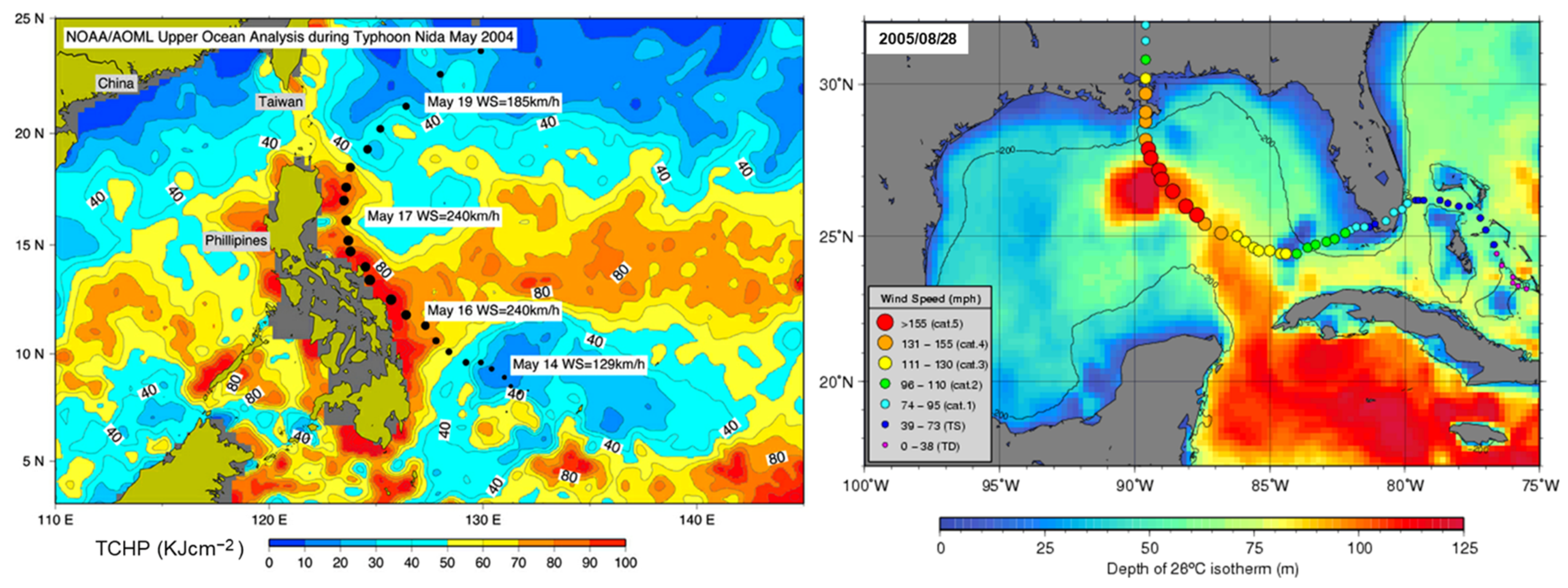
  99. Lin, I.-I.; Goni, G.J.; Knaff, J.A.; Forbes, C.; Ali, M.M. Ocean heat content for tropical cyclone intensity forecasting and its impact on storm surge. Nat. Hazards 2013, 66, 1481–1500. [Google Scholar] [CrossRef]
  100. Chen, S.; Curcic, M. Ocean surface waves in Hurricane Ike (2008) and Superstorm Sandy (2012): Coupled model predictions and observations. Ocean Model. 2016, 103, 161–176. [Google Scholar] [CrossRef]
  101. Song, Y.T.; Ji, C.; Fu, L.; Zlotnicki, V.; Shum, C.K.; Yi, Y.; Hjorleifsdottir, V. The 26 December 2004 tsunami source estimated from satellite radar altimetry and seismic waves. Geophys. Res. Lett. 2005, 32, 1–5. [Google Scholar] [CrossRef] [Green Version]
  102. Smith, W.H.F.; Scharroo, R.; Titov, V.; Arcas, D.; Arbic, B. Satellite Altimeters Measure Tsunami. Oceanography 2015, 18, 11–13. [Google Scholar] [CrossRef] [Green Version]
  103. Titov, V.; Song, Y.T.; Tang, L.; Bernard, E.N.; Bar-Sever, Y.; Wei, Y. Consistent Estimates of Tsunami Energy Show Promise for Improved Early Warning. In Global Tsunami Science: Past and Future; Geist, E.L., Fritz, H.M., Rabinovich, A.B., Tanioka, Y., Eds.; Pageoph Topical Volumes; Birkhäuser: Cham, Switzerland, 2016; Volume I. [Google Scholar] [CrossRef]
  104. Hamlington, B.D.; Leben, R.R.; Godin, O.A.; Gica, E.; Titov, V.V.; Haines, B.J.; Desai, S.D. Could satellite altimetry have improved early detection and warning of the 2011 Tohoku tsunami? Geophys. Res. Lett. 2012, 39, L15605. [Google Scholar] [CrossRef] [Green Version]
  105. Sandwell, D.T.; Smith, W.H.F.; Gille, S.; Kappel, E.; Jayne, S.; Soofi, K.; Coakley, B.; Géli, L. Bathymetry from space: Rationale and requirements for a new, high-resolution altimetric mission. Comptes Rendus Geosci. 2006, 338, 14–15. [Google Scholar] [CrossRef] [Green Version]
  106. Gille, S.T.; Metzger, E.J.; Tokmakian, R. Seafloor topography and ocean circulation. Oceanography 2004, 17, 47–54. [Google Scholar] [CrossRef] [Green Version]
  107. Vinogradova, N.; Hamlington, B. Sea level science and applications support coastal resilience. Eos, 29 June 2022; 103. [Google Scholar] [CrossRef]
  108. Cazenave, A.; Gouzenes, Y.; Birol, F.; Leger, F.; Passaro, M.; Calafat, F.M.; Shaw, A.; Nino, F.; Legeais, J.F.; Oelsmann, J.; et al. Sea level along the world’s coastlines can be measured by a network of virtual altimetry stations. Commun. Earth Environ. 2022, 3, 117. [Google Scholar] [CrossRef]
  109. Benveniste, J.; Cazenave, A.; Vignudelli, S.; Fenoglio-Marc, L.; Shah, R.; Almar, R.; Andersen, O.; Birol, F.; Bonnefond, P.; Bouffard, J.; et al. Requirements for a Coastal Hazards Observing System. Front. Mar. Sci. 2019, 6, 348. [Google Scholar] [CrossRef] [Green Version]
Figure 1. NASA, along with CNES, NOAA, EUMETSAT, ESA, and other international partners, developed and launched a series of satellite altimetry missions beginning in 1992 with the launch of TOPEX/Poseidon. This was followed by the Jason series of missions, including Jason-1 (launched 2001), the Ocean Surface Topography Mission/Jason-2 (OSTM/Jason-2, launched 2008), and Jason-3 (2016), S6MF (2020), and most recently, the SWOT mission (2022). International partnerships will extend the time series of ocean surface topography as well as land water measurements into the next decade with the launch of Sentinel-6B (planned launch 2025) and beyond with new planned missions. (Image: NASA.)
Remotesensing 15 03939 g001
Figure 2. Comparison of the 25 km merged, multi-mission sea surface height anomaly (SSH-A) Level 4 data product from Copernicus Marine Environment Monitoring Service (CMEMS) with SWOT first light SSH-A imagery on 21 January 2023 shows the detection of structural features at about a 10-times-higher resolution for an area of the Gulf Stream off North Carolina. Image credit: NASA/JPL-Caltech, CNES, and CMEMS.
Remotesensing 15 03939 g002
Figure 3. Global average sea level change from 1992 to 2022. The rate of rise in sea level accelerated from 2.8 mm per year in the 1990s to 4.0 mm/year in 2022 as measured by satellite altimeters. Credit: NASA.
Remotesensing 15 03939 g003
Figure 4. Global sea level anomaly map produced as part of an operational system developed by the French space agency (CNES) and the Collecte Localisation Satellite (CLS) and distributed by the European Copernicus Marine Service. The SSALTO/DUACS system processes data from the altimeter missions Jason-3, Sentinel-3A, Satellite with ARgos and ALtiKa (SARAL), CryoSat-2, Jason-1 and -2, TOPEX/Poseidon, Envisat, Geosat Follow-On (GFO), European Remote-Sensing Satellite-1 and -2 (ERS-1 and -2), and Geodetic Satellite (Geosat) to provide a consistent and homogeneous catalog of products for applications, both for near-real-time applications and research studies. Credit: European Copernicus Marine Service.
Remotesensing 15 03939 g004
Figure 5. El Niño and La Niña are two phases of the ENSO, a climate pattern in the Pacific Ocean that results from interactions between wind patterns and ocean circulation. This graph shows the ENSO phase in the Pacific Ocean. Red shading indicates El Niño events when water in the index area is generally warmer, and the value of the time series is positive, and blue shading indicates La Niña conditions when the water is cooler, and the value is negative. Credit: NASA MEaSUREs/PO.DAAC.
Remotesensing 15 03939 g005
Figure 6. These images illustrate altimetry combined with sea surface temperature data and a two-layer model to show ocean heat potential. On the left is Typhoon Nida (2004), which intensified from a category 2 to a category 4 in a 10 h period when it crossed a region of warm water off the east coast of the Philippines. This warm water essentially fueling the storm can be characterized by its tropical cyclone heat potential (TCHP) derived from sea height anomaly and sea surface temperature fields. On the right, Hurricane Katrina (2005) ramped from category 2 to category 5 as its path passed over the warm water of the Gulf of Mexico Loop Current. TCHP maps are produced in near real time in all seven basins where tropical cyclones occur and are distributed daily on the web. Credit: NOAA AOML.
Remotesensing 15 03939 g006
Disclaimer/Publisher’s Note: The statements, opinions and data contained in all publications are solely those of the individual author(s) and contributor(s) and not of MDPI and/or the editor(s). MDPI and/or the editor(s) disclaim responsibility for any injury to people or property resulting from any ideas, methods, instructions or products referred to in the content.

