1. Introduction
Vipava valley (SW Slovenia) is located between the Karst plateau on the southwest side and the Nanos Mountain range in the northeast. The N and NE slopes of the valley are defined by a thrust front of Mesozoic carbonates over Tertiary flysch deposits [
1,
2,
3]. This overthrusting has resulted in steep slopes and fracturing of the rock, producing highly weathered carbonates and large amounts of scree deposits in the upper part of the valley. In the lower part, these slopes are characterized by a variety of different surface forms, among which recent and fossil polygenetic landslides are the most prominent mass movements. Superficial deposits range from large-scale, deep-seated rotational and translational slides to shallow landslides, slumps, and sedimentary gravity flows in the form of debris or mudflows reworking the carbonate scree and flysch material [
4,
5,
6,
7,
8]. The influence of tectonic fractures on mass movements is a common phenomenon in Slovenia, for example, the Ciprnik complex landslide in the Tamar Valley in northwestern Slovenia [
9]. Due to tectonic stresses in the hinterland of the Ciprnik landslide, the initially highly bedded rocks were additionally fractured. This intense fracturing caused an increase in the effective porosity and a decrease in the strength of the material [
9,
10]. The relationship between tectonics and gravitational movement in the Vipava Valley and similar extreme cases in the Alps and Dinarides point to the need for a complex study of geologic processes [
11].
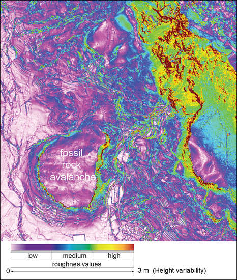
In this paper, we present the morphometrical analysis of two large sedimentary bodies of fossil rock avalanches, Podrta gora and Gradiška gmajna, and a few smaller detached and translationally moved carbonate blocks named Stara baba, Veliki strel, and Klapačiše in Zagriža. As a morphometric indicator, we used a variation of roughness index; the variability of surface elevation was used, using five different methods [
12]. Quantification of the variability of surface roughness was based on the height variability method (HV) [
4]. This method is based on the differences in elevations obtained from a digital elevation model with a high spatial resolution (1 m × 1 m), derived from lidar scanning.
Based on the geomorphometric analyses of surface roughness in conjunction with geomorphological and geological mapping, two main types of displacements were analyzed in the considered work: structurally conditioned displacements (at the fault zone) and Quaternary displacements caused by gravitational processes. By studying fossil and (sub)recent landslides, we were able to identify the shape of the crown, main, and lateral edges, as well as the geomorphometric characteristics at the top of the single sedimentary body of rock avalanche.
2. Materials and Methods
2.1. Geological Setting
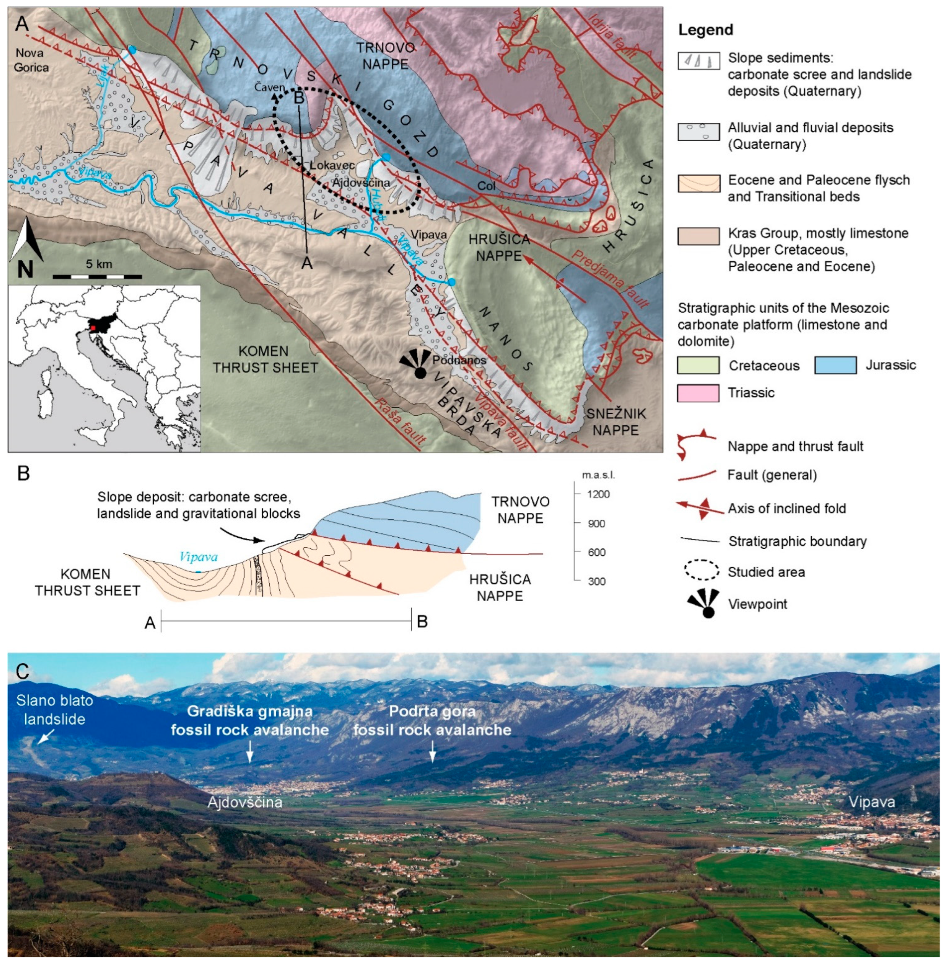
The general topography of the Vipava Valley is determined by thrust fronts of the Trnovo and Hrušica nappes composed of Mesozoic shallow-marine limestone and dolomites. Carbonates are thrust over gentle slopes of strongly folded Paleocene and Eocene basinal clastics deposits (flysch), which are composed of alternating sandstone, shale, and marl beds (
Figure 1). The Mesozoic carbonate rocks are highly fractured along the thrust contacts and are cut by large NW–SE striking, Neogene, dextral, strike-slip faults characterized by fault zones up to 300 m wide [
11,
13,
14].
The structural contact is expressed morphologically by the difference in lithology between the steep carbonate rocks in the massif and the gentler slopes of the underlying flysch in the lower part of the slope. This lithologic boundary, formed by the thrust contact, is covered by a variety of Quaternary slope deposits, broadly divided into two groups. The first group is lithified and unlithified scree deposits covering the upper part of the slope, while the second group is partially cemented complex Quaternary slope deposits covering the lower part of the slope. The latter represents a series of composite, fan-shaped sedimentary bodies with different compositions, internal structures, and textures, indicating a complex depositional history and polyphase genesis [
4,
6,
15,
16,
17]. Quaternary slope deposits are moderately sorted and consist of gravel to medium boulder-sized clasts. Rarely, very large (approximately several meters in a linear direction) individual boulders are also present. In addition, carbonate megablocks reaching more than 100 m in length are found at the lower parts of the slopes (e.g., in the Lokavec area near Ajdovščina). They were detached from the stable carbonate karst plateau and were transported up to 2 km by translational and rotational slope movements [
18] (
Figure 2).
The structural and lithological settings also determine the hydrogeological conditions; therefore, most springs originate close to the contacts between the limestone and flysch (springs of the Vipava, Lijak, and Hubelj rivers) [
14]. Many smaller springs also emerge within the gravel layers and lenses. These are very permeable and allow rapid infiltration of rainwater, which then flows within them and encounters significantly poorer permeable rocks in weathered flysch. In this area, the infiltrated rainfall water emerges in springs upon contact between the flysch below and the limestone gravel above and continues to flow superficially. The described geological structure and related hydrogeological conditions also influence the complex depositional processes of the slope deposit [
3,
4,
15,
19,
20,
21,
22,
23].
Figure 1.
(
A) Geological map of the extended area of the Vipava Valley; (
B) cross-section through the Trnovski gozd and Vipava Valley; (
C) panoramic view from Sveti Socerb to the Vipava Valley and Trnovski gozd in the hinterland (geological map modified after [
1,
3,
11,
14,
24,
25,
26,
27].
Figure 1.
(
A) Geological map of the extended area of the Vipava Valley; (
B) cross-section through the Trnovski gozd and Vipava Valley; (
C) panoramic view from Sveti Socerb to the Vipava Valley and Trnovski gozd in the hinterland (geological map modified after [
1,
3,
11,
14,
24,
25,
26,
27].
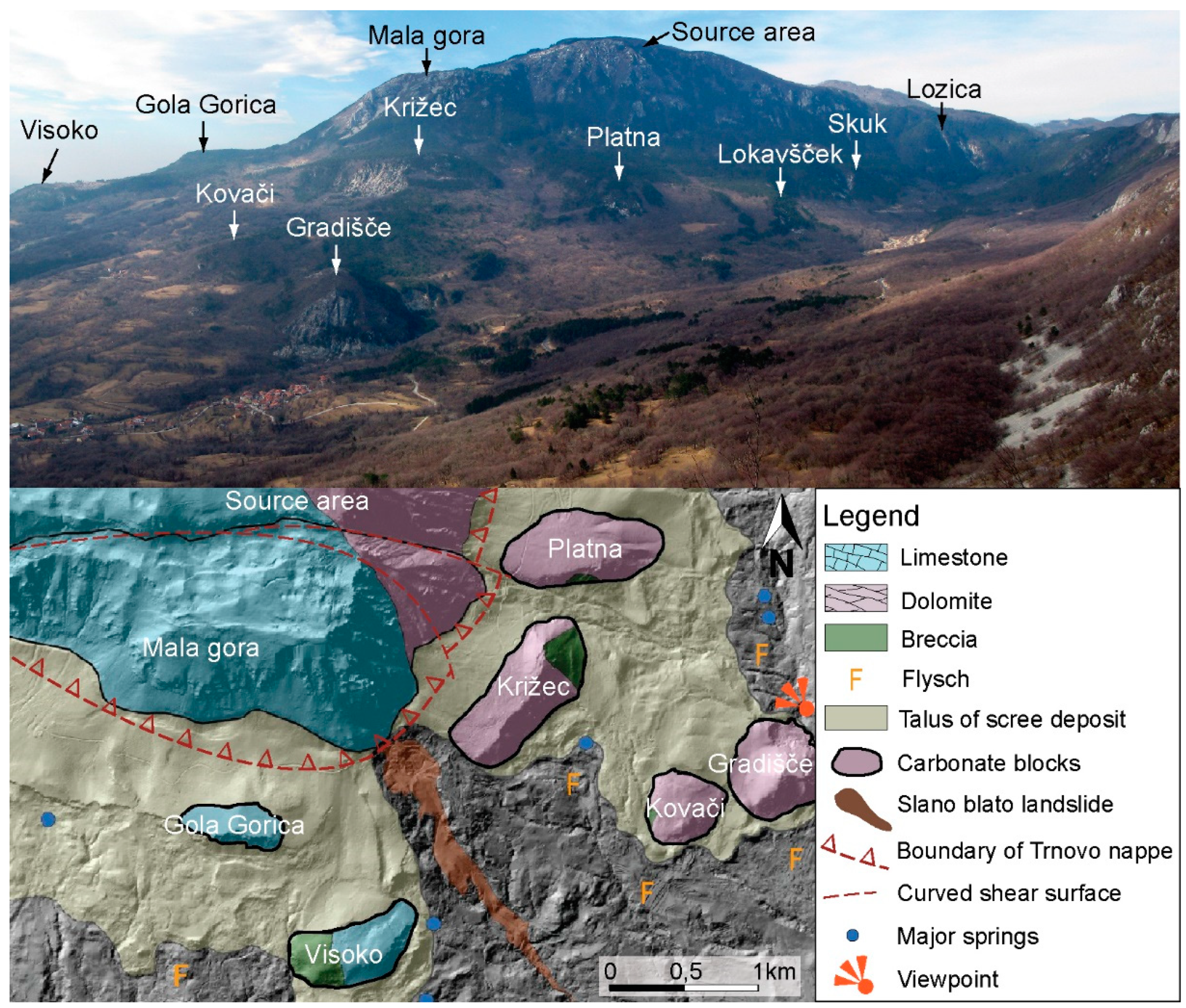
Figure 2.
Photograph of carbonate gravitational blocks (upper figure) from Navrše hill (view towards W) and lithology of the wider source area and carbonate blocks (lower figure). Adapted and modified after [
18]. Reprinted and adapted with permission from Ref. [
18]. Copyright 2019, Založba ZRC SAZU, Geografski inštitut Antona Melika”.
2.2. Geomorphological Analysis
A detailed digital hillshaded terrain model (DTM) was obtained from an openly available Airborne laser scanning (ALS) dataset of Slovenia [
28]. The ALS point cloud was rasterized to a 1 m × 1 m resolution and later, by a combination of filtering and removal of non-ground base points by adaptive triangulated irregular network densification [
12]. Relief Visualization Toolbox (Version 1.1 [
29]) was used to aid the visual inspection of the hillshaded DTM to emphasize the positive and negative geomorphological anomalies, which simplifies the geomorphological interpretation of the studied area [
12,
30,
31].
For quantitative geomorphological analysis of the rock avalanche surfaces, we have used several surface roughness methods which, apart from the surface curvature analyses, proved to be useful parameters for the investigation and detection of fossil landslides [
4,
12,
32,
33,
34,
35] and recent landslides [
36,
37,
38,
39,
40].
A quantitative analysis of the surface roughness of the studied sedimentary bodies of fossil rock avalanches was performed in the program ArcGIS using the height variability (HV) method, which proved to be the most useful among the several methods for the quantification and visualization of landslide parts with different sedimentary composition and genesis [
12]. The height variability method is performed on a raster elevation surface with, first, a resampling of the original 1 m × 1 m lidar resolution elevation data into a coarser 3 m × 3 m resolution (performed by the replacement of the center cell with the average value in the 3 m × 3 m moving window with the ArcGIS Focal Statistics tool) and, later, by the replacement of the center cell with the difference between the highest and lowest elevation (hence the name of the method) in the same window size. The original resolution turned out to be too detailed (too noisy) for further analyses. Larger moving windows were contrarily too coarse due to lost surface details.
The HV method is very similar to the method of slope variability cf. [
41]; the only difference is that it uses the difference between the maximum and minimum elevation instead of the slope difference: DTV
max–DTV
min [
12]. The results are given as the elevation difference (range) in meters, with a more variable (“rough”) surface inside the search window giving the higher numerical values. The advantage of this method is a very distinguishable visualization of areas with different roughness, which correspond well to different sedimentary processes on the landslide body. This method was tested on the Quaternary slope sedimentary bodies of (i) Podrta gora and Gradiška gmajna fossil rock avalanches; (ii) the adjacent gravity carbonate megablocks of Stara baba, Veliki strel, Klapačiše, and Zagriža on the slopes of the Vipava Valley; and (iii) on the structural elements in the hinterland high karst plateau.
We also suggest using the additional approach for geomorphometric analysis of the surface using the VAT method [
24,
42]. This method was originally named visualization for archaeological topography, and although the name comes from its primary use in archeology, it can be used to explore small-scale topographic variations also in geology or in any field of geomorphology, generally. It is based on the analysis of surface elevation data, and it combines several DEM-derived input layers: hillshaded relief, positive openness [
43], slope, and sky-view factor [
31], and blends them to combine the information into a single image (VAT) suitable for visual or quantitative inspection of the surface morphology features, helping with the interpretation of the surface changes (landslide, erosion, construction works, etc.). The VAT method is a part of the Relief Visualization Toolbox (RVT) described in [
31,
42]. We have tested the VAT method and found that it is extremely useful when analyzing smaller landslide features on fossil rock avalanches [
24]. However, in the presented case, in which we analyzed a much bigger (regional-scale) area several kilometers in size, the use of the VAT method did not contribute useful results to help with the interpretation of the terrain analysis.
3. Results
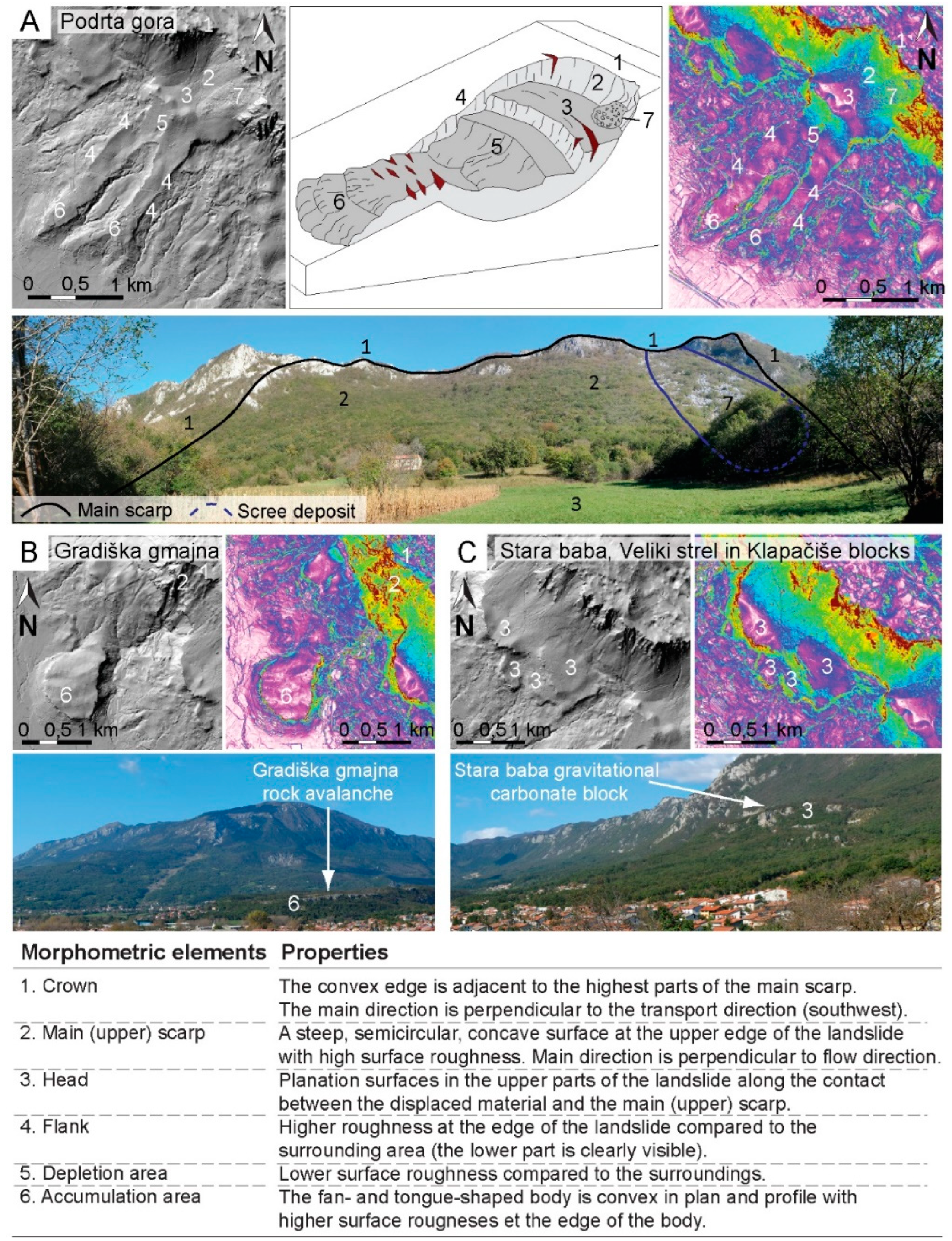
The HV values in the N and NE areas of the Vipava Valley reflect the differences between the surfaces of the flysch base and the surfaces of the fossil rock avalanche, gravity blocks built up of carbonate gravels, and structural elements in the hinterland of sedimentary bodies. Rock avalanches and carbonate blocks have high HV and a high degree of surface roughness at the edges, in contrast to flysch rocks, which have low HV and a low degree of surface roughness (
Figure 3). The exceptions are flysch-cut ravines, where greater erosion of flysch rocks occurs and which represent areas of greater slope inclination than the surrounding area [
44] and high height variability. The structural elements can be identified by linear changes in height variability.
3.1. Boundary of Individual Sedimentary Bodies and Their Source Area
The values of HV in the Podrta gora and Gradiška gmajna fossil rock avalanches are shown in
Figure 3. In narrow bands along the edges of the bodies, the variability is medium and rarely high, while the central part of the sedimentary bodies is mostly an area of low HV or low surface roughness. Medium to high HV is also observed in the narrow bands in the lower (fan-shaped) part of the Gradiška gmajna rock avalanche and in two tongue-shaped bodies of the Podrta gora rock avalanche (
Figure 3). Almost the entire narrow area of the margins of both sedimentary bodies is dominated by medium to large surface roughness, which is in sharp contact with the smooth surface. The boundary is partially blurred only in the SW part of the Podrta gora rock avalanche, where the difference in surface roughness is not strongly pronounced, and in the central part of the Gradiška gmajna rock avalanche, where the boundary between the sedimentary body and its surroundings is not definable. On the NE side of the Gradiška gmajna rock avalanche, the lateral edge is clearly visible, as the gorge of the Hubelj River is cut next to it (
Figure 3).
Aell-recognized geomorphological element is also the upper edge of the rock face in the hinterland of the Podrta gora and Gradiška gmajna rock avalanches (
Figure 3). Below the upper edge, the values of HV (in the form of a jagged convex edge) are very high and indicate a sharp boundary between the carbonate rock face and the karst surface at the top of Trnovski gozd in the area of Rob, Pravi vrh, and especially of Podrta gora (
Figure 3).
3.2. Boundary of Individual Sedimentary Bodies and Their Source Area
In both the Podrta gora and Gradiška gmajna rock avalanche areas and in the area between them, there are extensive areas with an extremely low degree of surface roughness (
Figure 3). These areas are the locations of the gravitational carbonate blocks named the Stara baba, Veliki strel, and Klapačiše sedimentary bodies and the Zagriža sedimentary body, located within the Podrta gora rock avalanche. The mentioned areas in the lower part, towards the SW, are adjacent to the areas of high surface roughness. The contacts between the smoothed and rough areas at the Stara Baba, Veliki Strel, and Klapačišče bodies are clearly concave in the downward direction, while the contact at the Zagriža body (within the Podrta gora rock avalanche) is approximately flat or slightly convex in the downward slope (
Figure 3).
3.3. Identification of Structural Elements in the Hinterland of Sedimentary Bodies
The HV method is also useful for identifying faults and fracture zones. Fracture deformation and crack structures are most evident in the area of high karst plateaus, where faults can be identified in line-by-line changes in the values of height variability. In some places, the value of surface roughness increases; in other places, the response of the rock mass to the fracture zone is just the opposite, and the HV decreases. The most pronounced are the northern part of the Predjama fault, which runs across the plateau above Rob, and the fault on Mala gora above the Slano blato (
Figure 3, cf. [
45]. Linearly distributed alterations are evident in the carbonate rock face in height variability, mostly oblique to the edges of the rock face. Most likely, this is a morphological reflection of fracture zones running at different angles between the main fault systems [
3,
14].
Generally, the middle and upper parts of the rock face of carbonate rock (yellow and red color), extending over the whole Vipava Valley, have the greatest HV values (
Figure 3). In the lower parts of the rock face in the foothills, the values of HV are medium (
Figure 3). The transition to the upper karst plateau of Trnovski gozd is morphologically pronounced, as medium values and sometimes low values of HV begin to predominate in the sharp line. This transition is related to the erosional frontal retraction of the overthrust fronts and to the structural features of the area. The lower boundary, at the base of the rock face, is directly related to the thrust or fault contact with the carbonate rocks and the flysch bedrock. The sharpness of the boundary is obviously determined by the thickness of the carbonate gravel or scree deposit. In places where individual sedimentary bodies with a lot of carbonate gravel are observed, higher values of surface roughness are obtained, while in areas with thin gravel, the value of HV is low.
4. Discussion
In general, landslides are complex and consist of parts with different geomorphological characteristics [
46,
47]. Using the visual interpretation of the digital evaluation model (DEM), and the calculated surface roughness indicator, we were able to identify the surface properties of the individual sediment bodies very well in most cases. Based on a combination of geomorphometric indicators, we conclude that the sedimentary bodies have a very complex structure formed by different Quaternary sedimentation processes. The analysis of the typical morphological elements found in the sedimentary bodies of the Podrta gora and Gradiška gmajna rock avalanches and on the rotational blocks of Stara baba, Veliki strel, Klapačiše, and Zagriža is presented in
Figure 4, cf. [
47,
48]. It has been shown that the degree of surface roughness is most strongly influenced by various sedimentation processes, in addition to the characteristics of the sedimentary material. Similarly, Grohmann et al. [
49,
50] determined that different surface roughness values are attributed to landslide formation processes (recent and fossil) and time elapsed since the surface formation, in addition to material characteristics.
The high contrast between the degree of surface roughness occurring at the margins of each body and the surface belonging to the surrounding and base of the sedimentary deposit reflects the difference between the two distinct lithologic units. The carbonate gravel or breccia belongs to the Gradiška gmajna and Podrta gora rock avalanches and to the Stara baba, Veliki strel, Klapačiše, and Zagriža gravity blocks. These blocks are characterized by a high degree of roughness, while flysch bedrock forms the base and immediate surroundings of sedimentary bodies, creating a relatively smooth surface.
4.1. Podrta Gora and Gradiška Gmajna Fossil Rock Avalanches
4.1.1. Crowns and Main Scarp
Based on the surface roughness, the upper edge above the Podrta gora and Gradiška gmajna landslides is clearly visible in the area of Rob, Pravi vrh, and Podrta gora (
Figure 3 and
Figure 4). The values of HV in this area are very high in the form of a convex edge. The areas of fossil rock avalanches determined by remote sensing correspond with the results of geological mapping. High values of surface roughness in this area indicate that this geomorphometric element represents the crowns and main scarps of the Podrta gora and Gradiška gmajna rock avalanches (
Figure 4A, points 1 and 2). The main direction of elongation of the crown and main scarp is perpendicular to the direction of mass transport, which is also one of the typical characteristics of crowns and can be detected at least in the case of the Podrta gora fossil rock avalanche, cf. [
47]. In the immediate vicinity of the main scarp is also an area of carbonate gravel, representing a recent scree deposit (
Figure 4A, point 7).
Figure 4.
Geomorphometric elements of sedimentary bodies: (
A) Podrta gora fossil rock avalanche; (
B) Gradiška gmajna fossil rock avalanche; and (
C) Stara baba, Veliki strel, and Klapačiše carbonate blocks, based on the classification of the schematic representation of the landslide. Adapted from [
46,
47,
48].
4.1.2. Minor (Lateral) Scarp of Fossil Rock Avalanches
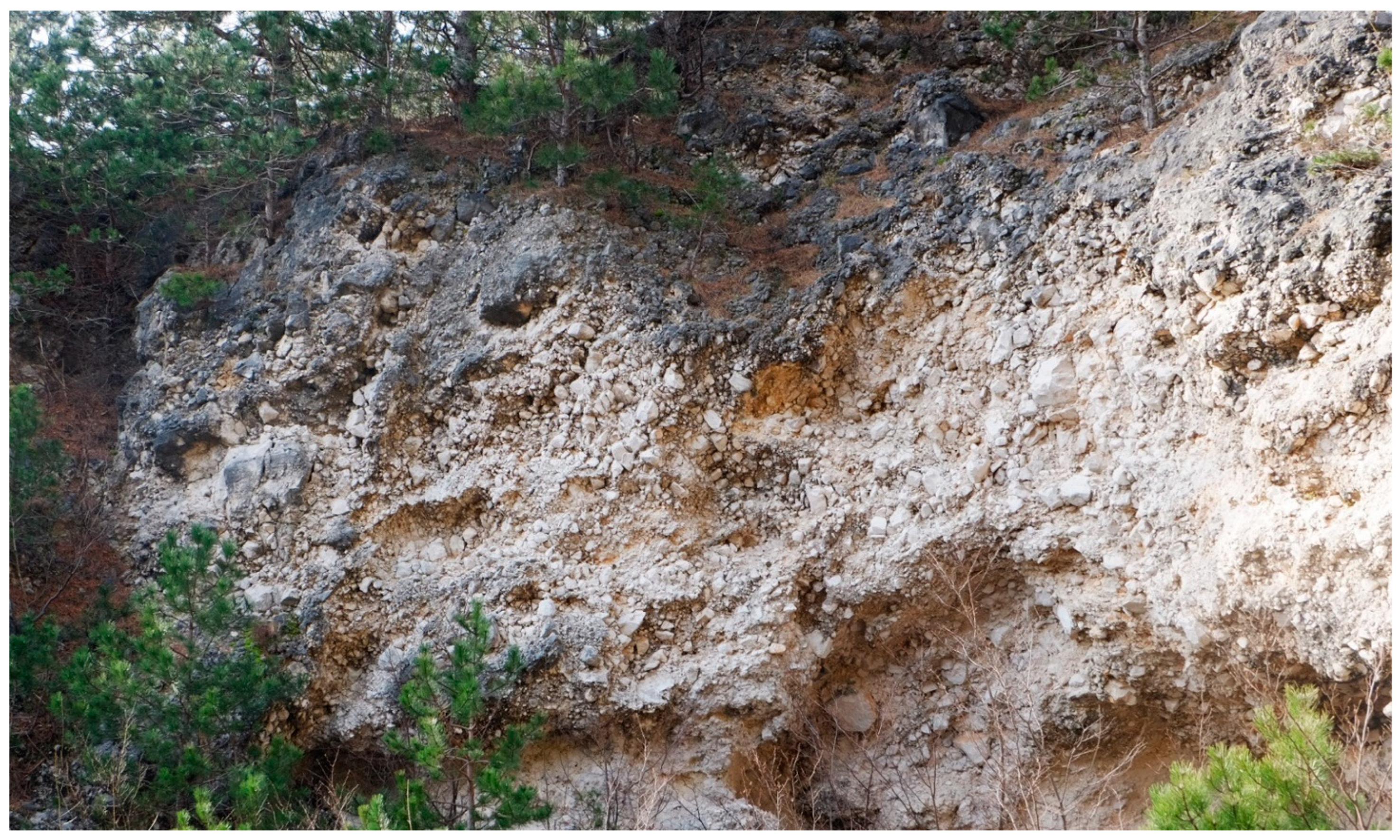
At the border of sedimentary bodies, especially in the lower part, sharp transitions of HV values occur. These locations are the steep boundaries between the flysch bedrock and the sedimentary bodies of the Podrta gora and Gradiška gmajna fossil rock avalanches, which are made of carbonate gravel, mostly lithified in a slope breccia (
Figure 5). Lateral scarps are areas of medium to high surface roughness, while the flysch bedrock is primarily a smooth area with an extremely low degree of HV (
Figure 3 and
Figure 4). The lateral scarps of sedimentary bodies are approximately parallel to the main direction of transport, which is one of the characteristic elements of landslides [
48]. The sharp transitions of HV at the periphery of the sedimentary bodies are also affected by the erosion of carbonate gravels and breccias. This is especially marked in the eastern part of the Gradiška gmajna fan-shaped sedimentary body, where the Hubelj River erodes part of the fan and changes its original shape (
Figure 3. Shulz [
51], for example, explained the lower reliability in detecting the lateral scarp and the toe of the Gradiška gmajna body precisely with the reworked surface of the fossil rock avalanches. The toe of the Gradiška gmajna rock avalanche with a high degree of surface roughness has also been eroded.
4.1.3. Geomorphometry of the Central Part of Sedimentary Bodies
The surface roughness is low in the interior of the Podrta gora and Gradiška gmajna fossil rock avalanche. It is particularly low in the central part of the tongue- or fan-shaped areas of the body. Similarly, Glenn et al. [
37] recognized the high surface roughness at the head scarp and the toe of rock avalanches. Surface roughness is different in different parts of a single landslide; namely, it is high in the areas of erosion and low in the body of the landslide [
36,
37].
The central parts of the sedimentary bodies were well identified at the Podrta gora rock avalanche, but this was the least accurate compared to other geomorphological elements. This is due to erosional processes that change the shape of the fan and increase the surface roughness. This can be seen in the eastern part of the Gradiška gmajna rock avalanche, where carbonate gravels occur at quite high elevations, at the source of the Hubelj, and the riverbed is cut to the flysch base (
Figure 3. Habič [
52] even stated that the water of the Hubelj River caused the sliding of the Gradiška gmajna breccia material, and the Gradišče carbonate breccia was displaced and transported when the breccia had already formed. The presence of the Hubelj karst spring [
53] even before the lithification of the older gravel into the breccia indicates that this carbonate gravel had dammed the karst spring for a long time, and such a dam could only form when larger quantities of gravel poured into the original riverbed in a relatively short time during stronger earthquakes [
52].
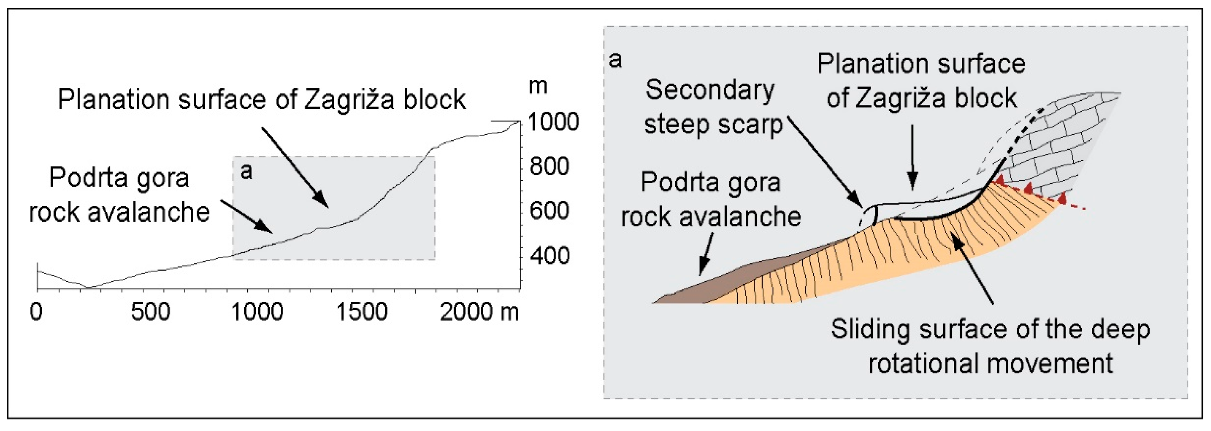
In the upper part of the Podrta gora rock avalanche is a large area of an accumulation of carbonate rocks with low surface roughness, most likely representing a huge rotational block that slid on the weathering flysch bedrock or muddy sediment at its base (
Figure 3). The block, which is divided into three parts, consists of strongly cracked carbonate rocks, while carbonate breccias and slope gravels occur only in the hinterland. Similar gravity blocks were recorded near the Lokavec slide in a combination of translational and rotational block-type slope movements [
18]. The gravitational block of Podrta gora most likely represented the first transport phase of the complex Podrta gora rock avalanche, from which a huge gravel landslide further developed and was transported in the form of a rock avalanche in the Vipava Valley. The two phases of the Podrta gora rock avalanche mass movement are also evidenced by the forms of the secondary scarp (convexity in the downward direction) in the Zagriža area (
Figure 3). The latest proposed classification system by Hungr et al. [
54], modified after Varnes [
55] and Cruden and Varnes [
48], classifies two-phase landslides in the class of complex landslides, and their transport complexity is referred to as a two-phase event [
56]. In contrast to the two-phase Podrta gora rock avalanche, the two-phase transport process is not observed in the case of the Gradiška gmajna rock avalanche. The large area of the main scarp and the well-defined upper crown, as well as the large fan-shaped body in the lower part of the avalanche, may indicate that Gradiška gmajna represents a huge rockfall in the initial (first) phase, which further developed into a debris avalanche.
4.2. Gravitational Blocks
4.2.1. Planation Surface Area
Based on the analyses, we have identified many areas of extremely low surface roughness (Stara baba, Veliki strel, and Klapačiše), which spread upwards to individual scree deposits in the foothills. Individual planation surfaces were formed by large rotational slides, where individual blocks of the carbonate breccias rotated along the sliding surface at the contact of the gravel with the underlying flysch bedrock. The blocks of breccia also tilted towards the slope as they slid (
Figure 6). At the outer edges, there was even a reverse tilt of the breccia blocks and the formation of steep rock faces with an extremely high degree of surface roughness and smooth areas in the hinterland depression. Similar geomorphometric features in the Rebrnice area were also recognized [
6,
19].
4.2.2. Structurally Conditioned Movement
By analyzing the geomorphometric features, we can recognize the structurally induced movement. Today, the blocks are generally inactive and are important mainly because of their influence on the geological structure of the area [
14,
26,
45,
57]. The contact between the flysch and carbonate bedrock in the northwestern part of the area (north of the Gradiška gmajna rock avalanche) is at significantly higher elevations than in the central part. Thus, we find the highest flysch outcrops in the area of Gosta meja at 475 m and at the source of Hubelj at 240 m above sea level [
14]. The structure in this area is a depressional synclinal bend of the overthrust surface of the Trnovo nappe with an axis in a northeast–southwest direction [
57]. In addition, a regionally significant Avče fault was explored in the area, which would be at least a partially displaced thrust fault in this area [
26,
57]. In the Hubelj Spring area, detailed geological mapping identified a complex, highly branched NW–SE oriented fault system, one segment of which merges with the northern branch of the Predjama fault [
14]. Thus, in the studied area, we are dealing with a complex structure, within which we cannot determine the structural significance of a single segment of the contact between the carbonates and flysch on the basis of the outcrops alone due to the overlap of the outcrops. Indeed, it can be assumed that the structures triggered a significant reduction of the thrust fault and, thus, influence the formation and hydrogeological characteristics of the area. At the same time, the diversity and intensity of the slope processes in this part of the examined area have significantly increased.
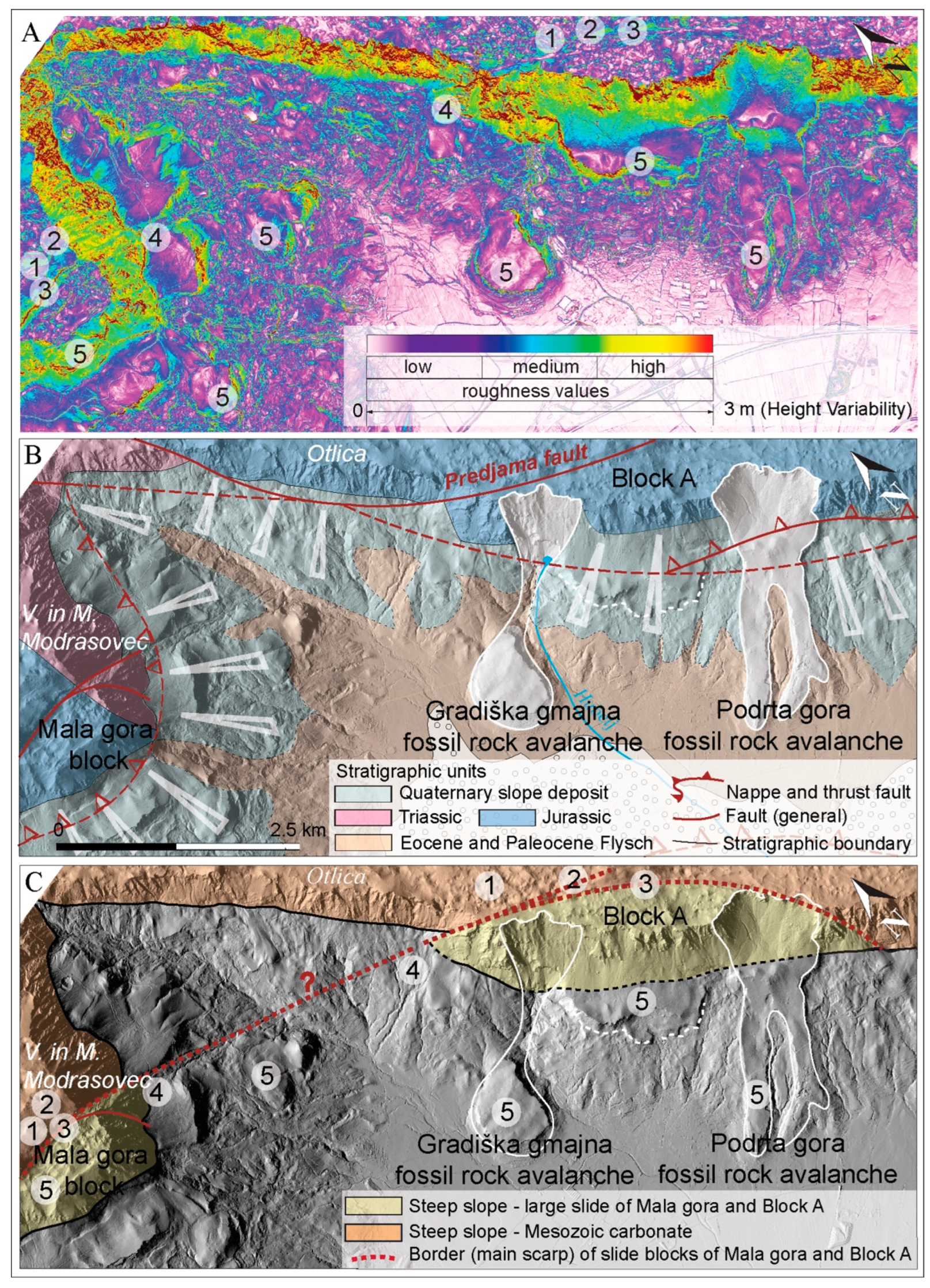
On the nearby Mala gora on the other side of the valley of the Lokavšček stream (
Figure 7A), Placer et al. [
45] suggested so-called structural landslides, reportedly also known in the Rebrnice area [
58]. The exposed carbonate massif of Mala gora slides in the form of a large (deep-seated) rotational slide about 300 m down the slope toward the valley, including the flysch layers in the slide. The sliding surfaces (main scarps) in the carbonate massif represent the shape of normal faults in the hinterland of the Mala gora block [
45].
A comparison of the results of the geomorphometric characteristics of the whole study area with the situation in Mala gora provides some details, namely:
- (1)
The linear distribution of the change in the degree of HV values along the northern branch of the Predjama fault is comparable to the main ridge of the Mala gora carbonate block (
Figure 7A,C, point 1);
- (2)
Areas north of both lines show greater HV values than those southwest (
Figure 7A,C, point 2);
- (3)
The lines are arcuately curved (
Figure 7A,C, point 3);
- (4)
The southern carbonate massifs (Mala gora and Block A) in the concave part of the lines are subsided (
Figure 7A,C, point 4);
- (5)
Intense recent and sub-recent gravitational movements are observed on the lower slopes in the concave part of these lines (
Figure 7A,C, point 5).
Based on these results, we propose that the whole area between Rob and Podrta gora, analogous to the Mala gora massif, could be part of a large carbonate block, settled relative to the hinterland. The movement of the carbonate block (Block A;
Figure 7A,C) occurred along the fracture surface of the Predjama fault in the western part and most likely along roughly parallel fracture zones in the eastern part. Consequently, the displacement of Block A also affected the increased intensity and diversity of gravitational movements in the lower part of the slopes, such as the large fossil rock avalanches Podrta gora and Gradiška gmajna. Based on the observed similarities, two questions regarding the geological history of the area are still unanswered: whether the lowered thrust fault in the area under consideration is only an influencing factor or if it is an active participant in the gravitational movement of rock masses. The other question is if the linear geomorphometric elements indicate a connection with the Mala gora main scarp and the fault zone of the northern branch of the Predjama fault. It is possible that both displacements could belong to a large-scale structural movement of Mala gora and Block A (
Figure 7C).
5. Conclusions
Based on the geomorphometric analyses of surface roughness, we have roughly distinguished two main types of displacements: structurally induced displacements (along the fault zone) and displacements caused by Quaternary gravitational slope processes. Quaternary slope deposits were studied geomorphometrically on two larger sedimentary bodies, the Podrta gora and Gradiška gmajna fossil rock avalanches, and on some smaller gravitational carbonate bodies—Stara baba, Veliki strel, Klapačiše, and Zagriža. It turns out that the quantitative parameter of surface roughness proved to be very useful in the studies of fossil and recent or sub-recent rock avalanches or landslides, generally. Specifically, we were able to detect very well the shapes of the main and minor scarps, as well as the geomorphometric characteristics of the deposits within individual bodies. In addition, structural elements that influence mass movements have been successfully identified.
The degree of surface roughness depends mainly on various deposition processes, in addition to material properties. The visualization of roughness values in a GIS environment allowed us to understand the two phases of complex avalanches that evolved from a sliding rotational landslide, in the case of Podrta gora, or a large rockfall, in the case of Gradiška gmajna, to a rock avalanche. The cases of the Stara baba, Veliki strel, and Klapačiše gravity blocks indicate large translational–rotational slides. In this sense, we strongly recommend the use of surface roughness analysis in future research of mass movements induced by various displacement causes. In addition, the geomorphometric analyses also revealed some peculiarities in the structural observation, the most pronounced element being the sliding of the huge carbonate block on the Predjama fault in the hinterland of the fossil rock avalanches and carbonate blocks. A comparison of the geomorphometric elements of the carbonate block (A) with the Mala gora rotational block above Lokavec shows that the whole area may be a part of a major rotational slide of the carbonate massif that was displaced partly along older fault structures.
Author Contributions
Conceptualization, T.P., B.R., A.Š., A.N. and T.V.; methodology, T.V. and T.P.; writing—original draft preparation, T.P., B.R., A.Š., A.N. and T.V.; writing—review and editing, T.P., B.R., A.Š., A.N. and T.V.; visualization, T.P. and T.V.; funding acquisition, T.P. and T.V. All authors have read and agreed to the published version of the manuscript.
Funding
This research was partly funded by the Slovenian Research Agency’s core funding (No. P1-0195—Geoenvironment and Geomaterials).
Acknowledgments
The work was carried out in the framework of the International Consortium on Landslides (ICL), project number IPL-216 (entitled Diversity and Hydrogeology of Mass Movements in the Vipava Valley, SW Slovenia), and the ICL Adriatic–Balkan Network (ABN). We appreciate the constructive comments and suggestions made by the anonymous reviewers.
Conflicts of Interest
The authors declare no conflict of interest. The sponsors had no role in the design execution, interpretation, or writing of the study.
References
- Placer, L. Geologic structure of south-western Slovenia. Geologija 1981, 24, 27–60. [Google Scholar]
- Placer, L. Contribution to the macrotectonic subdivision of the border region between Southern Alps and External Dinarides. Geologija 1998, 41, 223–255. [Google Scholar] [CrossRef]
- Popit, T.; Rožič, B.; Šmuc, A.; Kokalj, Ž.; Timotej, V.; Košir, A. A lidar, GIS and basic spatial statistic application for the study of ravine and palaeo-ravine evolution in the upper Vipava Valley, SW Slovenia. Geomorphology 2014, 204, 638–645. [Google Scholar] [CrossRef]
- Popit, T.; Verbovšek, T. Analysis of surface roughness in the Sveta Magdalena paleo-landslide in the Rebrnice area. RMZ-Mater. Geoenviron. 2013, 60, 197–204. [Google Scholar]
- Verbovšek, T.; Košir, A.; Teran, M.; Zajc, M.; Popit, T. Volume determination of the Selo landslide complex (SW Slovenia): Integrating field mapping; ground penetrating radar and GIS approaches. Landslides 2017, 14, 1265–1274. [Google Scholar] [CrossRef]
- Popit, T. Origin of planation surfaces in the hinterland of Šumljak sedimentary bodies in Rebrnice (upper Vipava valley, SW Slovenia) = Nastanek reliefnih izravnav v zaledju sedimentnih teles Šumljak na Rebrnicah (zgornja Vipavska dolina, SW Slovenija). Geologija 2017, 60, 297–307. [Google Scholar] [CrossRef]
- Jemec Auflič, M.; Jež, J.; Popit, T.; Košir, A.; Maček, M.; Logar, J.; Petkovšek, A.; Mikoš, M.; Calligaris, C.; Boccali, C.; et al. The variety of landslide forms in Slovenia and its immediate NW surroundings. Landslides 2017, 14, 1537–1546. [Google Scholar] [CrossRef]
- Verbovšek, T.; Popit, T. GIS-assisted classification of litho-geomorphological units using Maximum Likelihood Classification, Vipava Valley, SW Slovenia. Landslides 2018, 15, 1415–1424. [Google Scholar] [CrossRef]
- Šmuc, A.; Janecka, K.; Lempa, M.; Kaczka, R.J. The spatio-temporal dynamics of the Ciprnik complex landslide, Tamar Valley, Julian Alps, Slovenia. Stud. Geomorphol. Carpatho-Bal. 2015, 49, 35–54. [Google Scholar] [CrossRef]
- Novak, A.; Popit, T.; Šmuc, A. Sedimentological and geomorphological characteristics of Quaternary deposits in the Planica-Tamar Valley in the Julian Alps (NW Slovenia). J. Maps 2018, 14, 382–391. [Google Scholar] [CrossRef]
- Placer, L. Vipavski prelom. Geologija 2008, 51, 101–105. [Google Scholar] [CrossRef]
- Popit, T.; Supej, B.; Kokalj, Ž.; Verbovšek, T. Primerjava metod za geomorfometrične analize hrapavosti površja na primeru Vipavske doline = comparison of methods for geomorphometric analysis of surface roughness in the Vipava valley. Geod. Vestn. 2016, 60, 227–240. [Google Scholar] [CrossRef]
- Čar, J.; Gospodarič, R. Geološka zgradba in nekatere hidrološke značilnosti bruhalnika Lijaka = Geological Setting and some Hydrological Properties of Lijak Effluent. Acta Carsologica 1988, 17, 13–32. [Google Scholar]
- Janež, J.; Čar, J.; Habič, P.; Podobnik, R.; Hlad, B. Vodno Bogastvo Visokega Krasa: Ranljivost Kraške Podzemne Vode Banjščic, Trnovskega Gozda, Nanosa in Hrušice; Geologija d.o.o: Idrija, Slovenia, 1997; ISBN 961-90568-0-9. [Google Scholar]
- Popit, T.; Košir, A. Pleistocene debris flow deposits in the Vipava Valley, SW Slovenia. In Proceedings of the 22nd IAS Meeting of Sedimentology: E-Abstracts Book; Vlahovič, I., Ed.; Institute of Geology: Zagreb, Croatia, 2002. [Google Scholar]
- Popit, T.; Košir, A.; Šmuc, A. Sedimentological Characteristics of Quaternary Deposits of the Rebrnice Slope Area (SW Slovenia). In Knjiga Sažetka, Proceedings of the 3rd Znastveni Skup Geologija Kvartara u Hrvatskoj s Međunarodnim Sudjelovanjem, Zagreb, Croatioa, 21–23 March 2013; HAZU: Zagreb, Croatia, 2013. [Google Scholar]
- Novak, A.; Verbovšek, T.; Popit, T. Heterogeneously composed Lozice fossil landslide in Rebrnice area; Vipava valley = Heterogeni fosilni plaz Lozice na območju Rebrnic v Vipavski dolini. Geologija 2017, 60, 145–155. [Google Scholar] [CrossRef]
- Kocjančič, M.; Popit, T.; Verbovšek, T. Gravitational sliding of the carbonate megablocks in the Vipava Valley, SW Slovenia. Acta Geogr. Slov. 2019, 59, 7–22. [Google Scholar] [CrossRef] [Green Version]
- Jež, J. Vzroki in mehanizem zemeljskega plazenja na Rebrnicah v Vipavski dolini = Reasons and mechanism for soil sliding processes in the Rebrnice area, Vipava valley, SW Slovenia. Geologija 2007, 50, 55–63. [Google Scholar] [CrossRef]
- Popit, T.; Košir, A. Kvartarni paleoplazovi na Rebrnicah. In Povzetki in Ekskurzije, Proceedings of the 3rd Slovenski Geloški Kongeres, Bovec, Slovenia, 16–18 Septmber 2010; Znanstvenoraziskovalni center SAZU; Inštitut za raziskovanje krasa; Paleontološki inštitut Ivana Rakovca: Postojna, Slovenia, 2010. [Google Scholar]
- Košir, A.; Martín-Pérez, A.; Popit, T. Zakaj je Slano blato slano? In Proceedings of the 21st Posvetovanje Slovenskih Geologov, Ljubljana, Slovenia; Geološki Zbornik: Ljubljana, Slovenia, 2013; p. 22. [Google Scholar]
- Popit, T.; Jernej, J.; Košir, A.; Fifer Bizjak, K.; Ribičič, M. Kvartarni pobočni sedimenti severnega in vzhodnega roba Vipavske doline (Quaternary slope sediments of northern and eastern border of the Vipava Valley). In Abstracts and Field Trips, Proceedings of the 4th Slovenian Geological Congress, Ankaran, Slovenia, 8–10 October 2014; Rožič, B., Verbovšek, T., Vrabec, M., Eds.; Faculty of Natural Sciences and Engineering: Ljubljana, Slovenia, 2014; pp. 98–103. [Google Scholar]
- Ribičič, M. Zemeljski plazovi. In Vipavska dolina. Neživi svet; rastlinstvo; živalstvo; zgodovina; umetnostna zgodovina; gmotna kultura; gospodarstvo. In Naravovarstvo; Pavšič, J., Ed.; Slovenska Matica: Ljubljana, Slovenia, 2013; ISBN 978-961-213-242-2. [Google Scholar]
- Verbovšek, T.; Popit, T.; Kokalj, Ž. VAT Method for Visualization of Mass Movement Features: An Alternative to Hillshaded DEM. Remote Sens. 2019, 11, 2946. [Google Scholar] [CrossRef]
- Buser, S. Basic geological map of SFRJ 1:100,000. In Guide for Sheet Gorica; Federal Geological Survey: Belgrade, Yugoslavia, 1973; p. 50. [Google Scholar]
- Buser, S. Basic geological map of SFR Yugoslavia 1:100,000. In Gorica Sheet; Federal Geological Survey: Belgrade, Yugoslavia, 1968. [Google Scholar]
- Placer, L.; Vrabec, M.; Celarc, B. The bases for understanding of the NW Dinarides and Istria Peninsula tectonics. Geologija 2010, 53, 55–86. [Google Scholar] [CrossRef]
- ARSO Lidar Slovenia. Available online: http://gis.arso.gov.si/atlasokolja/profile.aspx?id=Atlas_Okolja_AXL@Arso (accessed on 28 February 2022).
- Zakšek, K.; Oštir, K.; Pehani, P.; Čotar, K. Relief Visualization Toolbox; Version 1.1. Manual; Research Centre of the Slovenian Academy of Sciences and Arts: Ljubljana, Slovenia; Available online: Iaps.zrc-sazu.si/en/rvt (accessed on 28 February 2022).
- Kokalj, Ž.; Zakšek, K.; Oštir, K. Application of sky-view factor for the visualization of historic landscape features in lidar-derived relief models. Antiquity 2011, 85, 263–273. [Google Scholar] [CrossRef]
- Zakšek, K.; Oštir, K.; Kokalj, Ž. Sky-view factor as a relief visualization technique. Remote Sens. 2011, 3, 398–415. [Google Scholar] [CrossRef] [Green Version]
- Staley, D.M.; Wasklewicz, T.A.; Blaszczynski, J.S. Surficial patterns of debris flow deposition on alluvial fans in Death Valley; CA using airborne laser swath mapping data. Geomorphology 2006, 74, 152–163. [Google Scholar] [CrossRef]
- Cavalli, M.; Marchi, L. Characterisation of the Surface Morphology of an Alpine Alluvial Fan Using Airborne LiDAR. Hazards Earth Syst. Sci. 2008, 8, 323–333. [Google Scholar] [CrossRef]
- Cavalli, M.; Tarolli, P.; Marchi, L.; Dalla Fontana, G. The Effectiveness of Airborne LiDAR Data in the Recognition of Channel-bed Morphology. Catena 2008, 73, 249–260. [Google Scholar] [CrossRef]
- Jaboyedoff, M.; Oppikofer, T.; Abellán, A.; Derron, M.-H.; Loye, A.; Metzger, R.; Pedrazzini, A. Use of LIDAR in Landslide Investigations: A Review. Nat. Hazards 2012, 61, 5–28. [Google Scholar] [CrossRef] [Green Version]
- McKean, J.; Roering, J. Objective landslide detection and surface morphology mapping using high-resolution airborne laser altimetry. Geomorphology 2004, 57, 331–351. [Google Scholar] [CrossRef]
- Glenn, N.F.; Streutker, D.R.; Chadwick, D.J.; Thackray, G.D.; Dorsch, S.J. Analysis of LiDAR-derived topographic information for characterizing and differentiating landslide morphology and activity. Geomorphology 2006, 73, 131–148. [Google Scholar] [CrossRef]
- Van Den Eeckhaut, M.; Poesen, J.; Verstraeten, G.; Vanacker, V.; Nyssen, J.; Moeyersons, J.; Van Beek, L.P.H.; Vandekerckhove, L. Use of LIDAR-derived images for mapping old landslides under forest. Earth Surf. Process. Landf. 2006, 32, 754–769. [Google Scholar] [CrossRef]
- Van Den Eeckhaut, M.; Poesen, J.; Gullentops, F.; Vandekerckhove, L.; Hervás, J. Regionall mapping and characterization of old landslides in hilly regions using LiDAR-based imagery in Southeren Flanders. Quat. Res. 2011, 75, 721–733. [Google Scholar] [CrossRef]
- Amundsen, J.; Johnson, S.; Rouse, K.; Wang, H. Using LiDAR-Derived DEM’s to Delineate and Characterize Landslides in Northern Kentucky and Hamilton County, Ohio. Available online: http://www.trishock.com/academic/pdf/lidar_landslides.pdf (accessed on 28 February 2022).
- Ruszkiczay-Rüdiger, Z.; Fodor, L.; Horváth, E.; Telbisz, T. Discrimination of Fluvial; Eolian and Neotectonic Features in a Low Hilly Landscape: A DEM-based Morphotectonic Analysis in the Central Pannonian Basin; Hungary. Geomorphology 2009, 104, 203–217. [Google Scholar] [CrossRef]
- Kokalj, Ž.; Somrak, M. Why Not a Single Image? Combining Visualizations to Facilitate Fieldwork and On-Screen Mapping. Remote Sens. 2019, 11, 747. [Google Scholar] [CrossRef] [Green Version]
- Yokoyama, R.; Shlrasawa, M.; Pike, R.J. Visualizing topography by openness: A new application of image processing to digital elevation models. Photogramm. Eng. Remote Sens. 2002, 68, 251–266. [Google Scholar]
- Zorn, M. Ali se zavedamo hitrosti erozijskih procesov—Primer iz Slovenske Istre. Dela 2007, 28, 183–195. [Google Scholar] [CrossRef]
- Placer, L.; Jež, J.; Atanackov, J. Strukturni pogled na plaz Slano Blato. Geologija 2008, 51, 229–234. [Google Scholar] [CrossRef]
- Van Den Eeckhaut, M.; Kerle, N.; Poesen, J.; Hervas, J. Identification of vegetated landslides using only a lidar-based terrain model and derivatives in an object-oriented environment. In Proceedings of the 4th GEOBIA, Rio de Janeiro, Brazil, 7–9 May 2012. [Google Scholar]
- Van Den Eeckhaut, M.; Kerle, N.; Poesen, J. Object-oriented identification of forested landslides with derivatives of single pulse LiDAR data. Geomorphology 2012, 173–174, 30–42. [Google Scholar] [CrossRef]
- Cruden, D.M.; Varnes, D.J. Landslides types and processes. In Landslides: Investigation and Mitigation; Transportation Research Board Special Report 247; Turner, A.K., Schuster, R.L., Eds.; National Academy Press: Washington, DC, USA.
- Grohmann, C.H.; Smith, M.J.; Riccomini, C. Surface Roughness of Topography: A Multi-Scale Analysis of Landform Elements in Midland Valley, Scotland. In Proceedings of the Geomorphometry, Zurich, Switzerland, 31 August–2 September 2009. [Google Scholar]
- Grohmann, C.H.; Smith, M.J.; Riccomini, C. Multiscale Analysis of Topographic Surface Roughness in the Midland Valley, Scotland. IEEE Trans. Geosci. Remote Sens. 2011, 49, 1200–1213. [Google Scholar] [CrossRef] [Green Version]
- Shulz, W.H. Landslide susceptibility revealed by LIDAR imagery and historical records, Seattle, Washington. Eng. Geol. 2007, 89, 67–87. [Google Scholar] [CrossRef]
- Habič, P. Kraški Svet Mad Idrijco in Vipavo.: Prispevek k Poznavanju Razvoja Kraškega Reliefa; Slovenska Akademija Znaosti in Umetnosti, Razred za Prirodoslovne in Medicinske Vede: Ljubljana, Slovenia, 1968. [Google Scholar]
- Trček, B.; Veselič, M.; Pezdič, J. The vulnerability of karst springs—A case study of the Hubelj spring (SW Slovenia). Environ. Geol. 2006, 49, 865–874. [Google Scholar] [CrossRef]
- Hungr, O.; Leroueil, S.; Picarelli, L. The Varnes classification of landslide types, an update. Landslides 2014, 11, 167–194. [Google Scholar] [CrossRef]
- Varnes, D.J. Slope movement types and processes. In Landslides: Analysis and Control; Special Report 176. Transportation research board; Schuster, R.L., Krizek, R.J., Eds.; National Academy of Sciences: Washington, DC, USA, 1978. [Google Scholar]
- Deline, P.; Alberto, W.; Broccolato, D.; Hungr, O.; Noetzli, J.; Ravanel, L.; Tamburini, A. The December 2008 Crammont rock avalanche; Mont Blanc massif area; Italy. Nat. Hazards Earth Syst. Sci. 2011, 11, 3307–3318. [Google Scholar] [CrossRef] [Green Version]
- Placer, L.; Čar, J. Problem podzemeljske razvodnice Trnovskega gozda; Križne gore in Črnovške planote. Acta Carsologica 1974, 6, 81–93. [Google Scholar]
- Placer, L. Vzroki nastajanja recentnih in subrecentnih plazov na Rebrnicah—Geohazard z vidika kompleksnosti geoloških procesov. In Proceedings of the 18th Posvetovanje Slovenskih Geologov, Ljubljana, Slovenia; Geološki Zbornik 19: Ljubljana, Slovenia, 2007. [Google Scholar]
| Publisher’s Note: MDPI stays neutral with regard to jurisdictional claims in published maps and institutional affiliations. |
© 2022 by the authors. Licensee MDPI, Basel, Switzerland. This article is an open access article distributed under the terms and conditions of the Creative Commons Attribution (CC BY) license (https://creativecommons.org/licenses/by/4.0/).


