Article

Artificial Intelligence and Street Space Optimization in Green Cities: New Evidence from China

1
School of Urban Design, Wuhan University, Wuhan 430072, China
2
School of Arts and Communication, China University of Geosciences, Wuhan 430074, China
3
Huzhou University, Huzhou 313000, China
4
Westminster School of Arts, University of Westminster, London HA1 3TP, UK
5
School of Political Science and Public Administration, Wuhan University, Wuhan 430072, China
*
Author to whom correspondence should be addressed.
Sustainability 2023, 15(23), 16367; https://doi.org/10.3390/su152316367
Submission received: 1 November 2023 / Revised: 17 November 2023 / Accepted: 22 November 2023 / Published: 28 November 2023
(This article belongs to the Special Issue Green Economy, Resource Efficiency and Sustainable Development)

Abstract

:
In the context of the green economy and sustainable urban development, the rapid expansion of urban construction has given rise to pressing public health concerns, notably environmental pollution and the increased prevalence of chronic illnesses linked to swift urbanization. These urban health issues are escalating, prompting significant attention to the concept of creating “healthy cities”. Meanwhile, the planning and design of urban street space have a far-reaching impact on urban residents’ quality of life and health. Urban planners are facing challenges and need to follow the principle of a green economy while meeting the needs of residents for public activities and adapting to motor vehicle traffic. This study explores the optimization of urban street space to promote the harmonious coexistence between people and cars. This study actively explores the relationship between health, urban environment, and social background, focusing on promoting the harmonious coexistence between people and vehicles, especially the optimization goal of sharing urban streets. The study’s main goal is to design a road that can meet the needs of citizens’ public activities and accommodate motor vehicles, which conforms to the principle of a green economy. To achieve this, geographic information system (GIS) technology and a genetic algorithm (GA) are employed to optimize shared urban street spaces. Among them, GIS tools are used for spatial simulation to evaluate the effect of different shared street space configurations. The urban shared street space is gradually optimized through GA’s selection, crossover, and mutation operations. Simulation experiments are conducted to determine the relationship between street space utilization and the elements of a healthy city, ultimately striving to identify the optimal design parameters for shared street spaces. The research results reveal that the urban street space is optimized from the three aspects of shared allocation of facilities resources, replacement of land use functions, and mixed layout of facilities, and the utilization rate of urban streets is finally ensured to reach 53.43%, fully assuming the essential functions of urban streets. This innovative approach bridges the gap between urban development and public health, offering valuable insights for sustainable urban space planning and enhanced living environments within the framework of the green economy.

1. Introduction

1.1. Research Background

With the rapid expansion of Chinese cities, public health issues have become increasingly prominent, especially urban traffic problems and environmental problems such as air pollution due to the surge in motor vehicles. In the context of the green economy and sustainable urban development, the fast expansion of urban construction has triggered urgent public health issues such as environmental pollution and the rising prevalence of chronic diseases associated with rapid urbanization [1]. These problems not only threaten the health of residents but also negatively impact the city’s sustainability. In addition, changes in citizens’ lifestyles have also led to an increase in the risk of chronic diseases.
In this context, it is essential to rethink and optimize urban street design to address these issues. As part of the solution, the optimized design of street spaces in green cities aims to provide citizens with safe, enjoyable, and multifunctional activity spaces that promote social interaction, cultural exchange, and leisure activities. This helps improve the health and well-being of citizens and provides a platform for community development. At the same time, this optimized design can also meet the needs of motor traffic and comply with the principles of the green economy [2,3]. Specifically, through rational urban street planning, the environmental burden of the city can be reduced, energy efficiency can be improved, and greenhouse gas emissions can be decreased, thus better complying with the principles of the green economy. Moreover, encouraging sustainable transport solutions such as public transport, cycling, and electric vehicles can also help reduce traffic congestion and emissions.

1.2. Literature Review

1.2.1. Street Space Based on Healthy Cities

Urban planning and design are the core of healthy city research. The study focuses on designing urban space, including public streets, parks, buildings, and transportation systems, to provide a safe, convenient, and healthy environment. This includes improving pedestrian-friendly cities, green buildings, and urban public transport systems.
Contemporary research on healthy cities primarily encompasses two focal points. Firstly, there is an exploration of the intricate relationship between the built environment and public health, centering on the built environment’s impact on health outcomes. Secondly, scholarly endeavors delve into healthy city planning, emphasizing urban planning guided by the overarching objective of constructing a healthy city [4]. Several studies have elucidated a robust correlation between the built environment and physical activity. Some scholars have substantiated that the unreasonable layout of the built environment has an inhibitory effect on citizens’ physical activity. For example, scholars Capari et al. (2022) [5] believed that urban expansion and functional simplification caused 5% of citizens to lack sufficient physical exercise. Some scholars’ studies have proved that a well-built environment can promote the cultivation of citizens’ healthy living habits. Uddin and Jeong (2021) [6] discovered that shortening the service radius of bus stops significantly augmented the frequency of walking trips for low-income people. Furthermore, a well-built environment is beneficial to the mental health of citizens. Rinaldo et al. (2022) [7] found that community belonging positively affected residents’ psychological and physical health. This was because a sense of community belonging could stimulate the enthusiasm of residents to play sports. After 2003, the construction of healthy cities in China also began. Among them, the most representative was the construction of healthy cities in Suzhou and Shanghai.
Healthy city planning is a comprehensive field, requiring interdisciplinary cooperation and complete consideration of all urban residents’ health aspects. Urban planners, policymakers, and community leaders can create healthier cities by adopting innovative methods, thus improving the quality of life of urban residents. This field is still evolving, and with the continuous development of urbanization, it will continue to attract extensive research interest. A healthy city consists of three parts: the population, the environment, and the health of social relations, with the latter being a fundamental prerequisite. The cooperative relationship between the government, the private sector, and the citizen guarantees a healthy city. A healthy environment is a material condition that provides a support system for developing a healthy city, while the ultimate goal remains the well-being of the people. The synergy among these three facets forms an interconnected whole. Recent scholarship on healthy cities within the domestic academic landscape has included summarizing domestic and international experiences, health evaluation index systems, and health optimization of the built environment [8]. In the context of contemporary advancements in artificial intelligence (AI), this technological paradigm has found application in urban planning. Linardos et al. (2022) [9] provided an overview of the research studies focusing on ML and DL developed methods for disaster management. Junta et al. (2022) [10] suggested using convolutional neural networks for urban road traffic planning. Star (2022) [11] introduced the planning, maintenance, and operation processes at the urban infrastructure level of future smart cities, focusing on AI applications.
The concept of a healthy city entails designing and enhancing urban architectural spaces through a public health perspective. It can solve urban public health problems, improve the quality of urban space, and achieve the ultimate goal of healthy people [12].
Street space refers to a linear public space enclosed by the interfaces on both sides of the road in the city, serving as a place for citizenry to rest, move, and traverse. It constitutes an essential element of the urban built environment and directly or indirectly influences public health. It also affects citizens’ physical and mental health and the living environment. With the advent of motor vehicles and the rapid expansion of cities, urban living street spaces have been strongly impacted. The vehicle-dominated travel mode inhibits healthy travel modes such as walking and cycling in the street space. This causes atmospheric problems such as air pollution, reduces the probability of passive activities by residents, and increases the incidence of chronic diseases such as obesity and high blood pressure. The civic public space in the street is occupied by lots of motor vehicle parking. The lack of places for social interaction between citizens results in a sense of strangeness between people. It is not conducive to the formation of residents’ sense of community identity and will also significantly impact the health of citizens and urban environmental health.
Addressing street space-related challenges is imperative, involving considerations of urban traffic, urban appearance, residents’ health, urban living, and the commercial environment [13]. Thus, the primary focal points for optimizing urban street space revolve around three key principles. From “no harm to health” to “good for health”, the traditional street space design aims to avoid harming the health of citizens and pays attention to the security of health. From “negative space” to “positive space”, when there is no disease hazard, people’s view of space health design is always negative. Street spaces often fail to provide adequate health support when people realize their physical health is at risk. This leads to the inability to agree between people’s health cognition and space health design. “Positive space” can change citizens’ attitudes towards health and guide residents to participate in street space activities actively through health publicity and education. Lastly, moving from a “static space” to a “dynamic space” emphasizes leveraging the appeal of space to enhance the fluidity of space with the rapid development of technology. For example, the “dynamic” space can guide the “static” lifestyle by shortening the service radius of public service facilities and increasing the interest in the space. “Dynamic space” emphasizes the guidance of people’s behavior activities.

1.2.2. The Application of GIS in Urban Planning

This study’s main goal is to rethink urban streets’ spatial planning by using AI and GA technology to realize the construction of healthy cities. GIS is used to process geographic data, conduct spatial analysis, and create a simulation environment, while GA is used for multi-objective optimization (MOO) and the automatic allocation of decision weights. Integrating these two methods is conducive to considering many urban planning factors more comprehensively and providing better decision-support tools. GIS technology mainly includes three links: input, analysis and processing, and output. It involves four basic functions: data collection, management, spatial analysis and statistics, and result output. The unique spatial data query, management, analysis, and expression functions of GIS in geographic information can effectively serve urban planning and truly realize the combination of macro and micro, qualitative and quantitative [14]. GIS technology can be essential in data collection and analysis, simulation and prediction, program formulation and selection, and planning implementation and supervision. As one of the auxiliary tools for urban planning, it has efficient information access capabilities, professional mapping capabilities, and robust spatial simulation and analysis capabilities, and facilitates communication between various types of personnel.
The characteristics of GIS in planning data collection and management application, three-dimensional (3D) visualization application, spatial analysis, and statistical application are summarized by summarizing the application examples of GIS in urban planning. GIS can establish a concrete and dynamic 3D visual model in urban and regional planning, construction, and management. It can vividly and truly express urban and regional natural and humanistic phenomena. The application of 3D visualization is helpful for government management departments and designers to achieve scientific management and rational planning. It is also vital in pre-project, planning, and post-implementation evaluations. Here, the 3D planning map of X city is obtained through GIS technology. In addition, spatial analysis and urban street space optimization are performed.
GIS technology to assist urban design has become an increasingly common phenomenon. Areas of application cover ecological analysis, land use, road traffic, urban form, open space, and landscape features. Applied methods include surface analysis, visibility analysis, buffering, network analysis, overlay analysis, and 3D visualization. It is also necessary to expand to the fields that show the urban characteristic pattern and the daily life of citizens while drawing on and improving the existing application fields of GIS technology. It provides technical support and operation paths for the multi-faceted and multi-level guidance and control of the overall urban design.

1.3. Research Purpose

In the specific application of urban street space planning, AI-GA plays an important role in determining the weight of evaluation indicators. By automatically adjusting the weights, AI-GA can help planners better balance different factors to meet the specific goals of urban planning. AI-GA can be used to deal with multiple conflicting planning objectives, such as space utilization, environmental protection, and cost-effectiveness. This can help planners find the best solution to meet various needs. Although AI-GA shows great potential in urban planning and architectural design, there are still some limitations in practical applications. In the field of architectural design, the success of AI-GA is closely related to the accuracy and feasibility of modeling. For unstructured or complex design problems, algorithms may not accurately capture the designer’s creativity and intuition. The implementation of algorithms may be constrained by traditional processes and regulations in the construction industry and needs to be combined with actual construction processes to ensure feasibility and sustainability.
This study aims to explore the optimization of urban street space to promote the harmonious coexistence between people and cars. This study actively explores the relationship between health, urban environment, and social background, focusing on promoting harmonious coexistence of people and cars, especially the optimization goal of sharing urban streets. Specifically, this study investigates using geographic information system (GIS) technology and a genetic algorithm (GA) to achieve this goal. The existing research has been involved in urban planning, but there is still a gap. Most studies focus on a single factor, such as traffic flow or land use planning, and fewer consider the trade-off of multiple competing objectives. In addition, despite the application of GIS and other technologies, the integration and effective use of these technologies have yet to be fully explored in actual planning and decision-making. Therefore, the contribution of this study is to provide a comprehensive method to optimize urban street space by combining GIS technology and GA to achieve the balance of multiple goals, thus providing a more comprehensive perspective for sustainable urban planning. To sum up, this study uses GIS technology and GA jointly to find the best urban space utilization rate to optimize the urban street space. It obtains the maximum healthy city matching degree while ensuring the essential functions of city streets. This study has reference significance for urban planning.

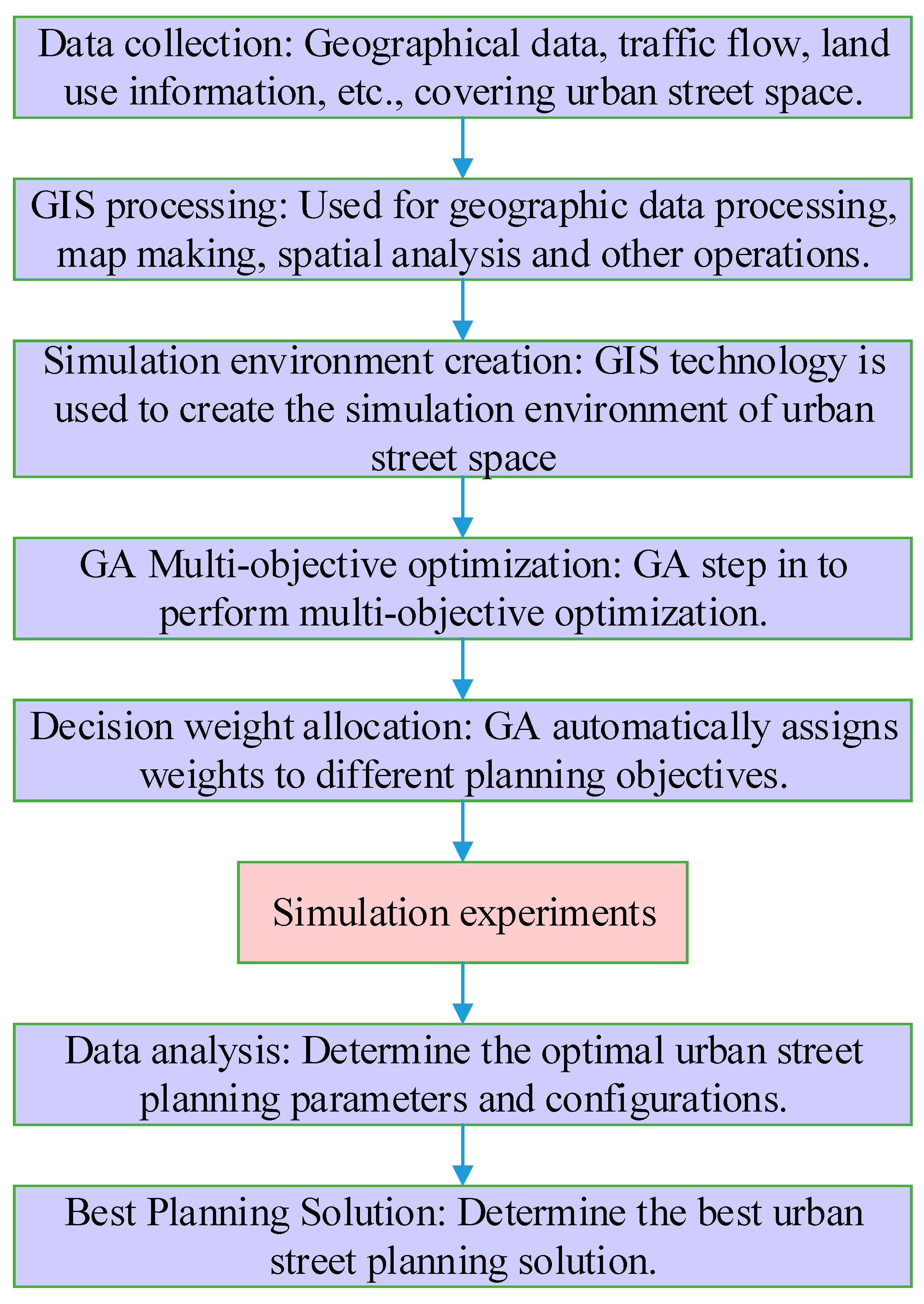
2. Materials and Methods

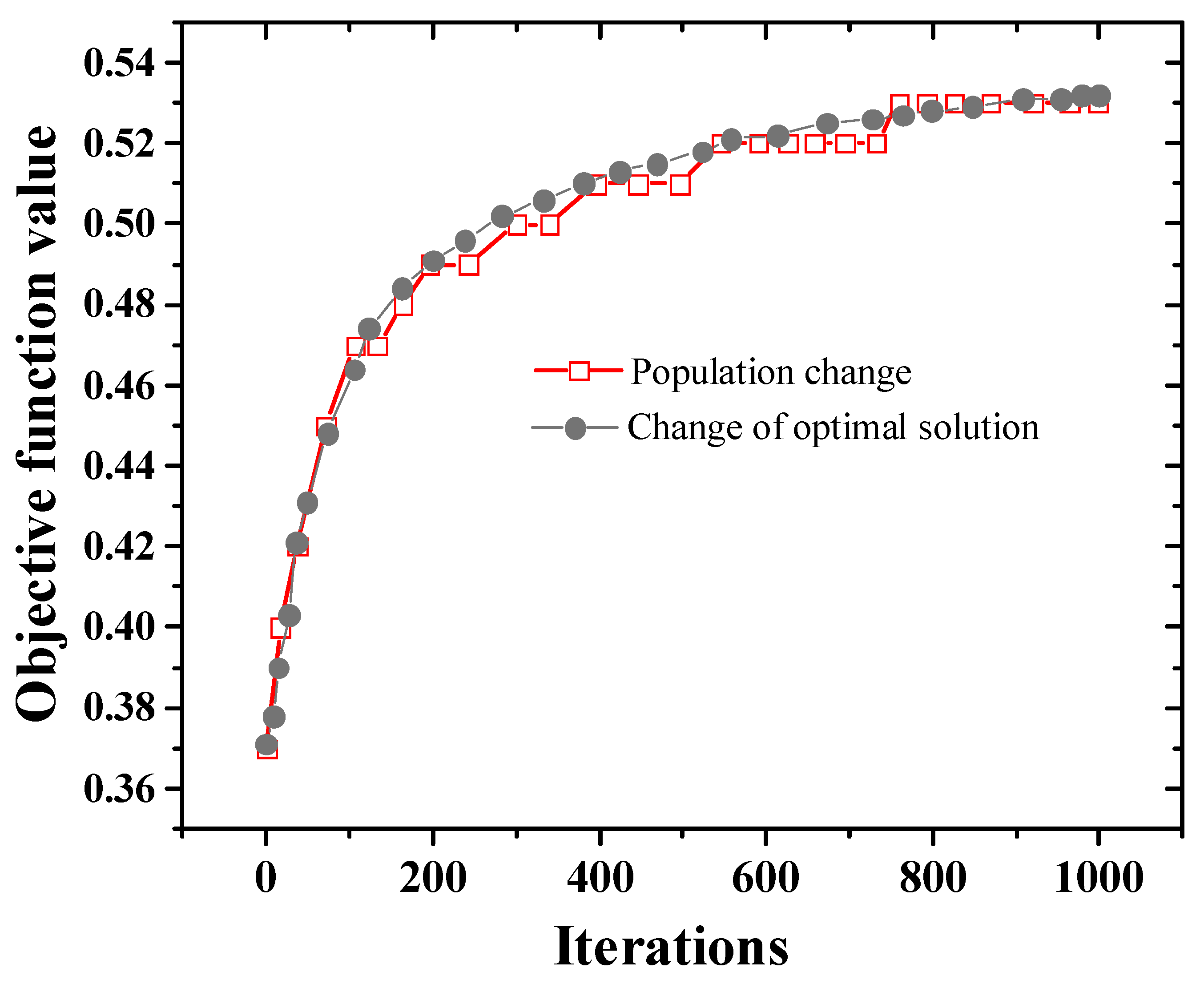
2.1. Objective Function Based on GA

The combined use of GIS and GA technology has achieved prominent success in urban planning. GIS has been used in traffic planning to analyze road network, intersection, and traffic flow data, and GA then used for route optimization and planning. This integration method has achieved remarkable results in optimizing urban traffic flow and reducing congestion.
In GIS analysis, this study focuses on the compactness of street space, traffic flow, and functional interweaving. Compactness evaluation involves the density of the road network and the distribution of buildings, traffic flow analysis takes into account the congestion of the road, and functional interweaving evaluation focuses on the relative location of different functional areas. Through GIS tools, the characteristics of urban space can be visualized, different aspects of street space utilization can be quantitatively analyzed, and the spatial basis for subsequent optimization can be provided. Through the selection, crossover, and mutation operations of GA, the new street space configurations are iteratively generated and optimized according to the evaluation results of the fitness function. This process continues until the optimal street space configuration is found. The introduction of GA can explore the optimal design of urban street spaces in a more intelligent and adaptive way, thus enabling more efficient urban planning and sustainable development. In AI, GA is a subset of Evolutionary Computation (EC) [15]. EC is a general population-based metaheuristic optimization algorithm. It is developed based on some phenomena in evolutionary biology. These phenomena comprise inheritance, mutation, natural selection, and hybridization. The candidate solutions act as individuals in the population. The fitness function determines the environment in which these solutions “live”. The population is assessed after the above operations are performed. Evolutionary algorithms are good at finding approximate solutions to all kinds of problems because they do not make any assumptions about the underlying fitness space of the problem. They are widely used in engineering, robotics, social sciences, etc.
The objective function is based on the space utilization of street space planning and the target matching degree of a healthy city, primarily involving the matching degree function, compactness function, and suitability function. The established objective function is as follows [16].
m a x { w 1 · i = 1 M j = 1 N M ( i , j ) + w 2 · i = 1 M j = 1 N C ( i , j ) + w 3 · i = 1 M j = 1 N S ( i , j ) }
In Equation (1), M and N are the number of rows and columns of the model grid, respectively. M, C, and S refer to the matching, compactness, and suitability functions. w 1 , w 2 , and w 3 indicate the weights corresponding to the objective function. The matching function is the correlation value between street space planning and healthy cities. The higher the correlation value, the higher the match.
The setting of the weights satisfies Equation (2).
w 1 + w 2 + w 3 = 1
Based on space utilization, urban street space utilization refers to the ratio of planned area to the available street space area. The available street space area is the total area of the model minus the unusable portion. Hence, street space utilization is expressed as [17]:
w = S p l a n S T o t a l   a r e a S S t u d y   a r e a S U n s u i t a b l e   a r e a
The matching degree function is calculated according to the correlation matrix. The correlation matrix represents the correlation between each street space type and healthy city indicators. Hence, the matching degree of the unit can be acquired according to the determined correlation matrix. This function embodies the principle of unifying street space utilization and a healthy city. It also maximizes street space development’s economic, social, and ecological benefits. The compactness function represents the compactness of the same type of street space. In street space development, the adjacency of similar street spaces is conducive to constructing, maintaining, and highlighting the functions of such street spaces. Therefore, the greater the utilization of street space, the better in a particular range. The specific definition of the utilization rate of a unit is the number of street spaces of the same type around R and R. When a cell is in a boundary case, its utilization is calculated by finding the eight other cells closest to the cell.
In the actual solution process, the value of the objective function is different, so it needs to be normalized. Therefore, the multi-objective functions can be compared. The normalization processing method is shown in Equation (4).
[ f ] = f f m i n f m a x f m i n
[f] refers to the normalized objective function. f means the original objective function. f m a x and f m i n represent the maximum and minimum values of the original objective function.

2.2. GA Based on Manual Intervention

The manual intervention process is introduced here to enhance the traditional GA. The manual intervention GA process adds a new artificial intervention operator-correction operator to the traditional GA. It improves crossover, mutation operators, and reinsertion methods, aiming for a more scientifically planned street space. With the objective function already established, the subsequent step involves seeking the optimal solution with the help of an improved manual intervention GA.
In GA, selection, crossover, and mutation are essential operators. A manual intervention GA improves these operators. The selection operator selects individuals with high fitness values in the population as the parent for crossover and mutation operations. The selection probability, determining the number of selected individuals, is implemented through the random traversal method. The crossover operator and mutation operator can be designed according to practical problems. For the planning problems of urban street space, two crossover operators and two mutation operators are employed to obtain the optimal solution. The first crossover operator facilitates random crossover using a single-point crossing approach, preventing convergence to local optima. The second crossover operator is a purposeful crossover set to increase compactness. The crossover condition is added under the premise of satisfying the crossover probability. At least two units of the same type exist in the adjacent units of the intersection [18].
The first mutation operator takes into account randomness. According to the mutation probability, the mutation point is randomly determined for the mutation to increase the diversity of the solution [19]. The second mutation operator is designed to enhance compactness. The mutation method randomly selects a mutation point and turns the eight surrounding units into units of the same type.
Given the complexity of optimizing the layout of urban street space, manual intervention becomes necessary, and correction operators are introduced for this purpose. The correction operator can artificially modify the genes on a chromosome to solve complex problems. Here, the non-research area and the unsuitable area are excluded by the correction operator. The units in the non-research and non-suitable areas are revised as unusable spaces, thereby refining the planning scope of the street space to focus on the developable research area.

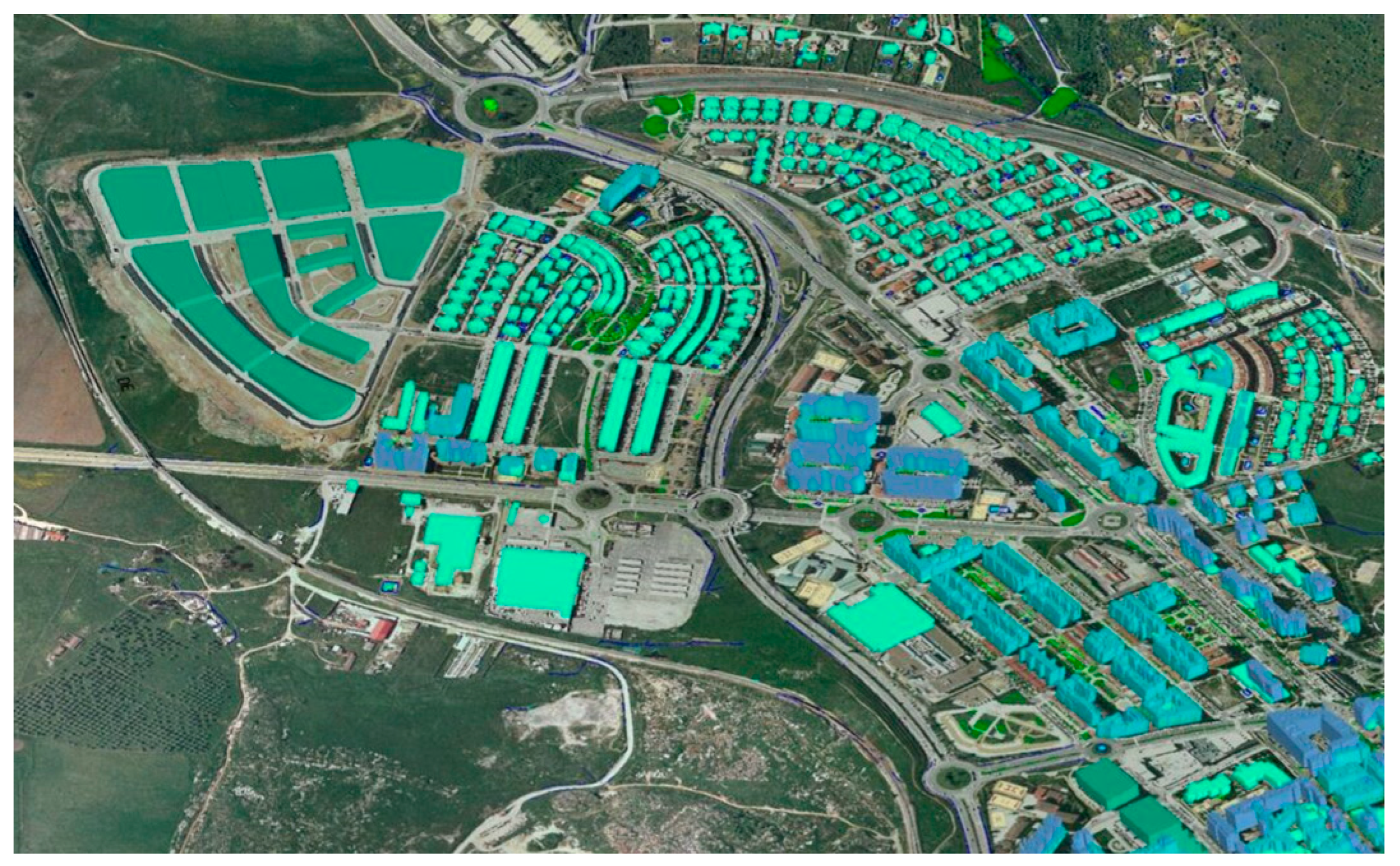
2.3. Urban Shared Street Space Optimization Strategy

This study starts from three aspects: shared allocation of facility resources, replacement of land use functions, and mixed layout of facilities to optimize urban street space to ensure that the utilization rate of urban streets is 53.43% and fully undertake the basic functions of urban streets. The specific optimization strategy of urban path planning is displayed in Figure 1.
1. Resource sharing configuration is a means to maximize the utilization of community resources. It integrates the facility’s resources in the area and allocates them reasonably according to the diverse activities of residents. The replacement of land use involves converting original residential and office land within a residential area into land dedicated to community service facilities. This addresses the challenge of insufficient service facilities within the community. The mixed arrangement of facilities is the centralized arrangement of two or more service facilities to achieve mutual promotion.
2. Functional replacement of land use refers to transforming the rich functional space of the area into facility land with greater demand according to the user’s needs. This method is employed to tackle the issue of inadequate community service facilities. It facilitates the optimal allocation of community resources while avoiding the disruption of the block’s architectural texture through extensive demolition and construction. In the function replacement, the street-facing residential space with ample functional space in the block and the remaining space of the office building can be selected as the transformation objects. They are replaced with the service facilities urgently needed by the citizens. Blocks targeted for the functional replacement of residential spaces facing the street are primarily residential areas. In addition, the building’s frontage interface is separated from the street and the building by a green belt or a closed fence to reduce the disturbance of street noise to residents’ lives. This method inhibits the neighborhood’s vitality and affects the quality of life of the lower-level residents.
3. Mixed arrangement of facilities refers to the mixed arrangement of two or more service facilities on the same land to promote each other and improve space utilization. Generally, the function should be balanced. A mixed form of one primary function and one auxiliary function can be adopted.
Figure 2 depicts the 3D planning map of the urban path obtained by GIS technology. Through GIS technology, the urban path network is clearly presented, involving main roads, block connections, and possible pedestrian areas. This provides planners with a comprehensive understanding of the city’s transportation network. Topographic and elevation information are included in Figure 2, allowing path planning to consider the city’s topography, such as climbing and descending, for smarter traffic design. Intersections and nodes are marked in Figure 2 to highlight key interchanges in the urban path. This helps planners optimize traffic flow and reduce congestion.
Urban planning must not only meet economic and social needs, but also consider the health and well-being of residents. Consequently, optimized urban street planning needs to consider public health factors, such as reducing environmental pollution, improving public activity space, and reducing traffic congestion. This comprehensive planning helps to create an urban environment more suitable for healthy living.
In the implementation of the method, a comprehensive research method is adopted, and the combination of manual intervention and GA is applied to urban planning. This comprehensive method helps planners to consider more comprehensively the relationship between different planning goals, and how to weigh these goals to find the best solution. Through simulation experiments and data analysis, people can evaluate the performance of different planning schemes and provide a more sustainable perspective for urban planning.

2.4. Evaluation System Based on Analytic Hierarchy Process (AHP)

The evaluation index system to determine the suitability of urban street space development is affected by many factors. A group of experts, including urban planning experts, traffic engineers, and environmental protection experts, are invited for this study. A pairwise comparison of different aspects and sub-indicators is made by means of expert scores. These experts provide consistent weight preferences based on domain knowledge and practical experience for each comparison. Key indicators should be selected in the suitability analysis to establish an evaluation index system [20]. The influence of some critical indicators on the suitability of street space development is analyzed, as exhibited in Table 1. Street space utilization is very important for urban planning and sustainable development. This index covers sub-indexes, such as compactness, traffic flow, and functional interweaving, because they are directly related to how streets meet the daily needs of urban residents. Street space suitability highlights the suitability of street space, including environmental protection, construction cost, and overall aesthetic feeling. These factors usually affect residents’ quality of life and cities’ sustainability. Street space activity considers how streets can promote different activities, involving leisure, social communication, and business development. These activities are vital to the social and economic life of the city. The research dataset of this study covers many aspects of urban street space, encompassing street layout, traffic flow, land use, and other key factors. These data come from China’s urban planning department, local government, and the GIS database.
The proposed evaluation method is to ask experts to rate the optimized street schematics. Then, it quantifies the street space before and after optimization through weight distribution and data processing. The expert scoring standard selects a five-level evaluation standard of “very good, good, average, poor, and very poor”. The scores correspond to 1 to 5 points, respectively.
In the simulation experiment, this study obtains detailed geographic data from urban planning departments and GIS databases, encompassing road networks, building distribution, land use, and other information. Using sensors, cameras, or other traffic monitoring equipment, traffic flow data are collected in different city areas, including vehicle type, speed, and flow information. GIS software (ArcGIS 10.8) is utilized to clean up, organize, and analyze the collected geographic data, to establish the geographic information database of the city. Through data processing tools, traffic flow data are analyzed, areas with high traffic and congestion are identified, and traffic conditions in various areas are quantified. The crossover rate of GA is set to 0.8, and the variation rate is usually set to 0.06.
In the concrete application of the evaluation index system of urban street space development suitability, AI can process large-scale urban data, encompassing factors like traffic flow, pollution level, and population distribution. This enables AI to offer profound insights into urban dynamics. Leveraging historical data analysis, AI can discern patterns and trends, thereby enhancing decision support for urban planners. In addition, AI’s predictive capabilities extend to forecasting future city requirements, such as future traffic demand, energy consumption, and environmental problems, to help plan future urban spaces. Urban planning usually involves many competing goals, such as space utilization, environmental friendliness, and cost-effectiveness. GA can be used to find the best balance point to cater to diverse goals.

3. Results

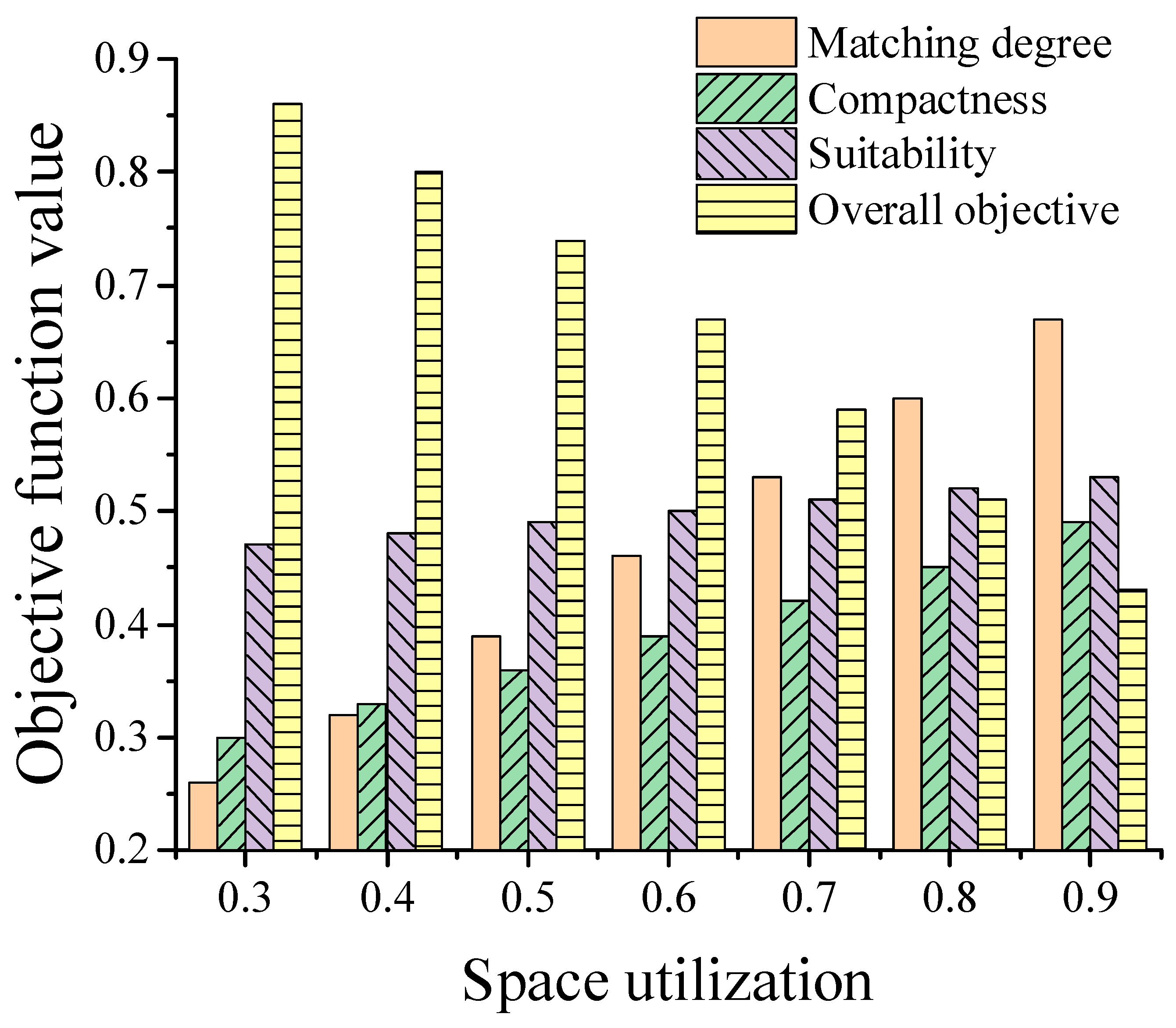
3.1. Research on the Relationship between Space Utilization and Fitness for a Healthy City

The four-dimensional (4D) optimization design of urban street space primarily encompasses diverse street spaces’ development modes and intensity. It is achieved by changing the weight of the objective function and the space utilization rate to align with the planning needs of different street spaces. The objective functions are treated equally when considering the 4D planning, and the objective function weights the urban street space in both the 2D plane planning and the 3D hierarchical planning, with an assigned weight value of 1/3. If a specific objective function is emphasized, the street space planning will be different to obtain the corresponding street space planning results. The compactness, matching, and suitability of the street plan are computed, and the outcomes are illustrated in Figure 3.
Figure 3 demonstrates that the urban space utilization rate, the suitability of urban planning, and the degree of matching with a healthy city are, to a certain extent, inversely proportional. With the increase in urban space utilization, the matching degree of urban planning suitability and a healthy city is declining. Consequently, it is vital to choose the appropriate urban street planning space utilization.

3.2. Research on Optimal Urban Street Space Utilization

Here, the optimal solution for the urban planning space utilization rate is calculated by adding artificial intervention GA to achieve the most suitable utilization rate for street planning. The optimization of urban street planning is completed under the requirements of ensuring a healthy city. The results are suggested in Figure 4.
The model’s calculation indicates that the trend of the optimal solution of the objective function and the population mean the same. Moreover, the optimal solution increases with the number of iterations and finally converges, illustrating that the resolution of the objective function is theoretically feasible. The value of the objective function after 1000 iterations is 53.43%, and the optimal urban planning space utilization rate is obtained. This is an essential parameter of urban planning to optimize urban street space.
To verify the performance advantages of the proposed AI-GA method in the street space optimization in green cities, it is compared with particle swarm optimization (PSO) and simulated annealing (SA) algorithms, and the specific results are outlined in Table 2. The comparison denotes that the AI-GA method has reached the best level in terms of compactness, environmental friendliness, and construction cost.

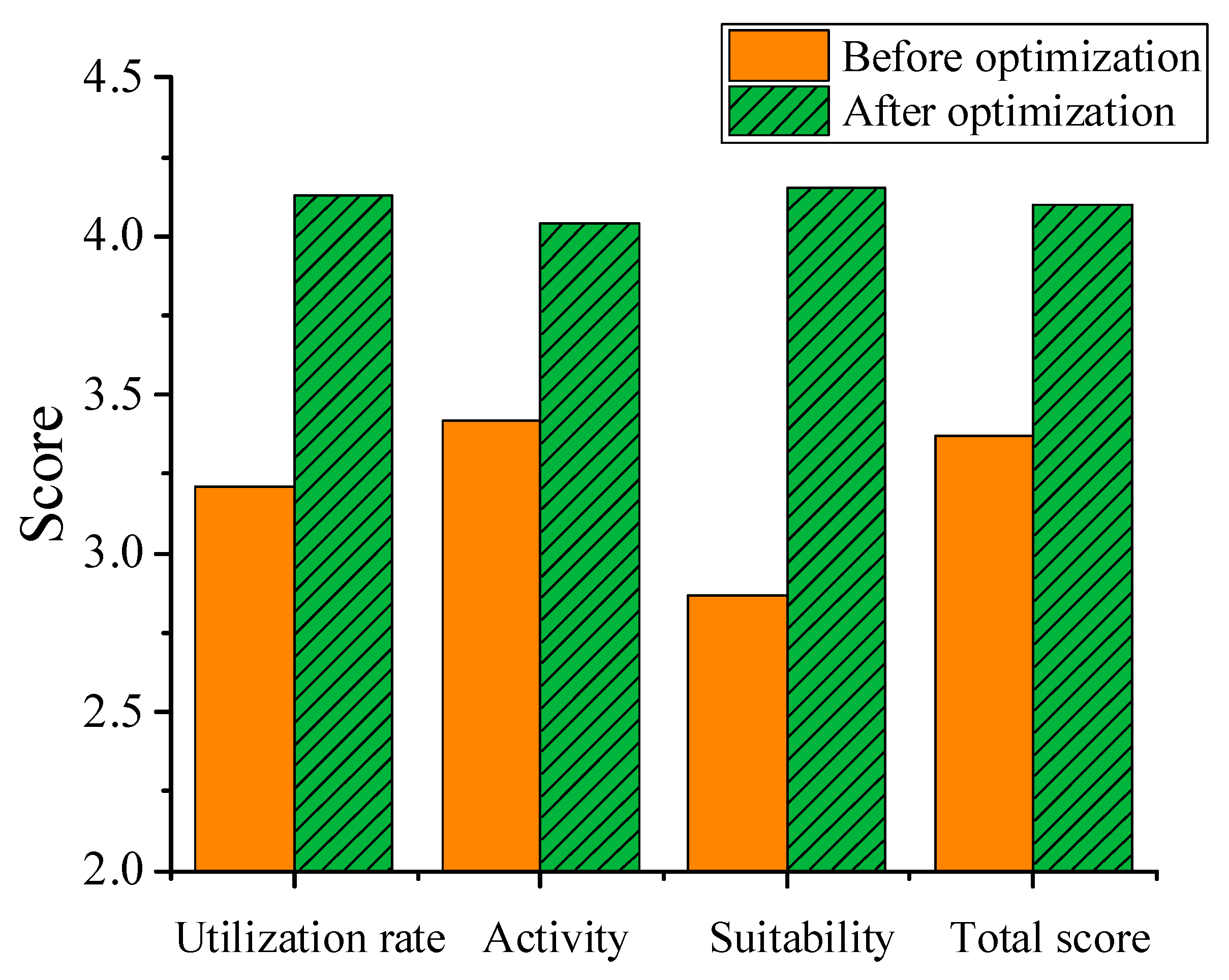
3.3. Optimization Evaluation of Urban Shared Street Space

Ten experts were asked to rate the schematic diagram of the effect before and after urban space optimization. Finally, data processing was carried out using the AHP. The scoring results are plotted in Figure 5.
Figure 5 signifies that the total score of the evaluation before the optimization of urban streets is 3.37. The evaluation results are fair and good. The total score of the assessment after optimization is 4.1. The evaluation results are between good and very good. The results imply that the optimization effect of urban street space is evident.

4. Discussion

Wang et al. (2023) [21] pointed out that with the swift growth of urbanization, urban planners were facing more and more challenges and needed to create a sustainable, healthy, and livable urban environment. Wang et al. (2023) [22] mentioned in their research that with increasing global climate change, the concepts of low-carbon, sustainable development, and green finance become more and more critical. Traditional urban planning methods often face complexity and diversity. Li et al. (2023) [23] believed that sustainable development was one of the key goals of urban street space optimization. To achieve this goal, it is necessary to consider how to meet the needs of the present generation without compromising the ability of future generations to meet those demands. This can be achieved by adopting ecologically sustainable measures, such as protecting biodiversity, reducing pollution, and conserving resources. Wang et al. (2023) [24] argued that green finance was a financial instrument that could provide financial support for environmental protection projects and sustainable development. Hu et al. (2023) [25] encouraged sustainable transport solutions such as public transport, cycling, and the use of electric vehicles as contributing to the reduction in traffic congestion and emissions. From the perspective of green finance, Li et al. (2023) [26] put forward the view that digital credit could analyze enterprises’ environmental behavior and energy consumption through big data, thus providing enterprises with low-cost green financing.
In this context, advanced technologies such as AI and GA have gradually become important tools in the field of urban planning. This section discusses the application of AI-GA in urban street space planning and compares it with the existing research to reveal the potential and challenges in this field. The application of AI-GA has had a positive impact on urban planning, providing powerful tools for urban planners to optimize decision-making and improve planning efficiency. The following are several key application fields of AI-GA in urban street space planning: In urban planning, the weight distribution of evaluation indicators is crucial for the decision-making process. AI-GA can be used to automatically determine the weights of different indicators to reflect their relative importance in evaluation. This process allows planners to better weigh different factors to meet the specific goals of urban planning, which is consistent with the research conclusion of Zhang et al. (2021) [27]. AI-GA’s MOO ability enables it to find the best balance point to meet multiple competitive goals, such as space utilization, environmental protection, and cost-effectiveness.
Urban planning usually involves many competing goals, such as improving space utilization efficiency, reducing environmental pollution, and improving traffic flow. ul Hussnain et al. (2020) [28] pointed out that the MOO technology of AI-GA could help planners find the best-balanced solution to meet the needs of different objectives. This helps urban planners weigh different stakeholders’ needs and formulate comprehensive planning schemes. AI-GA supports complex urban planning scenario analysis. By creating simulations and models, AI-GA can help planners predict the possible outcomes of different planning decisions, thus understanding the potential urban development paths. This helps planners better understand the consequences of different decisions to formulate wise urban planning strategies.
In urban planning, the existing research has confirmed the effectiveness of AI-GA in optimizing urban planning. For example, in the research of Halecki et al. (2023) [29], AI-GA was used to optimize urban traffic flow to reduce traffic congestion and exhaust emissions. They found that AI-GA could find a more optimized traffic flow scheme, reduce traffic congestion, and improve urban air quality compared with traditional planning methods. In the urban planning field, the application of AI and GA has made remarkable progress, offering powerful tools for urban planners to optimize decision-making and improve planning efficiency. Through weight distribution and MOO, GA helps planners to weigh different factors to meet the specific goals of urban planning. Scenario analysis and simulation enable planners to understand the consequences of different decisions to formulate wise urban planning strategies. In addition, existing scholars have also conducted in-depth studies on the remaining aspects, such as the 15 min city [30,31], urban design patterns for pedestrian and urban spaces [32,33], and network cities [34], which also give us a certain direction for future research.

5. Conclusions

This study employs GIS technology to obtain a 3D urban map to optimize the urban shared street space under the criteria of a healthy city. Urban space utilization, urban planning suitability, and matching for healthy cities are explored. The results show an inverse relationship. The optimal urban street space utilization rate is calculated by a GA with manual intervention. Ultimately, the optimal space utilization rate of urban streets reaches 53.43%. Under this utilization rate, the basic functions of urban streets can be ensured, and the standards of healthy cities can be met. Based on the best space utilization rate, three optimization strategies for urban streets; namely, the shared configuration of facility resources, the replacement of land use functions, and the mixed arrangement of facilities, are proposed. This strategy can effectively optimize the urban street space. In the field of urban planning, the application of AI and GA has made remarkable progress, providing powerful tools for urban planners to optimize decision-making and improve planning efficiency. Through MOO and weight distribution, AI-GA helps planners to better weigh diverse factors to meet the specific goals of urban planning. Scenario analysis and simulation enable planners to better understand the consequences of different decisions to formulate wise urban planning strategies.
The specific contribution of this study lies in the application of AI-GA in urban street space planning, which provides a more comprehensive tool for urban planners to optimize urban planning decisions. Compared with previous studies, the study emphasizes the diversity advantages of AI-GA, including weight allocation, MOO, and scene analysis. These advantages help urban planners meet residents’ requirements and create a more sustainable, healthy, and livable urban environment. However, there are some shortcomings. The urban optimization model is relatively rough and limited by the computing speed of the computer. In the future, the number of model units will be increased by improving the algorithm and hardware performance to achieve accurate urban street space planning.

Author Contributions

Conceptualization, Y.L. and S.Q.; methodology, Y.L. and S.Q.; software, J.L.; validation, T.J.; formal analysis, J.L. and T.J.; investigation, Y.L. and T.J.; resources, Y.L. and S.Q.; data curation, T.J.; writing—original draft preparation, Y.L., S.Q. and J.L.; writing—review and editing, T.J.; visualization, S.Q. and J.L.; supervision, T.J.; project administration, J.L. and T.J.; funding acquisition, T.J. All authors have read and agreed to the published version of the manuscript.

Funding

This research received no external funding.

Institutional Review Board Statement

Not applicable.

Informed Consent Statement

Not applicable.

Data Availability Statement

The data presented in this study are available on request from the corresponding author.

Conflicts of Interest

The authors declare no conflict of interest.

References

  1. Luo, W.; Deng, Z.; Zhong, S.; Deng, M. Trends, Issues and Future Directions of Urban Health Impact Assessment Research: A Systematic Review and Bibliometric Analysis. Int. J. Environ. Res. Public Health 2022, 19, 5957. [Google Scholar] [CrossRef] [PubMed]
  2. Lee, K.; Trujillo, L.; Olansky, E.; Robbins, T.; Brune, C.A.; Morris, E.; Finlayson, T.; Kanny, D.; Wejnert, C.; National HIV Behavioral Surveillance among Transgender Women Study Group. Factors Associated with Use of HIV Prevention and Health Care among Transgender Women—Seven Urban Areas, 2019–2020. Morb. Mortal. Wkly. Rep. 2022, 71, 673. [Google Scholar] [CrossRef] [PubMed]
  3. Søvold, L.E.; Naslund, J.A.; Kousoulis, A.A.; Saxena, S.; Qoronfleh, M.W.; Grobler, C.; Münter, L. Prioritizing the mental health and well-being of healthcare workers: An urgent global public health priority. Front. Public Health 2021, 9, 679397. [Google Scholar] [CrossRef]
  4. Morton, K.; Ainsworth, B.; Miller, S.; Rice, C.; Bostock, J.; Denison-Day, J.; Towler, L.; Groot, J.; Moore, M.; Willcox, M. Adapting behavioral interventions for a changing public health context: A worked example of implementing a digital intervention during a global pandemic using rapid optimisation methods. Front. Public Health 2021, 9, 668197. [Google Scholar] [CrossRef] [PubMed]
  5. Capari, L.; Wilfing, H.; Exner, A.; Höflehner, T.; Haluza, D. Cooling the city? A scientometric study on urban green and blue infrastructure and climate change-induced public health effects. Sustainability 2022, 14, 4929. [Google Scholar] [CrossRef]
  6. Uddin, M.J.; Jeong, Y.-K. Urban river pollution in Bangladesh during last 40 years: Potential public health and ecological risk, present policy, and future prospects toward smart water management. Heliyon 2021, 7, e06107. [Google Scholar] [CrossRef]
  7. Rinaldo, N.; Toselli, S.; Gualdi-Russo, E.; Khyatti, M.; Gihbid, A.; Zaccagni, L. Anthropometric assessment of general and central obesity in urban moroccan women. Int. J. Environ. Res. Public Health 2022, 19, 6819. [Google Scholar] [CrossRef]
  8. Sheng, P.; Yang, T.; Zhang, T. The Unmet Medical Demand among China’s Urban Residents. Int. J. Environ. Res. Public Health 2021, 18, 11708. [Google Scholar] [CrossRef]
  9. Linardos, V.; Drakaki, M.; Tzionas, P.; Karnavas, Y.L. Machine learning in disaster management: Recent developments in methods and applications. Mach. Learn. Knowl. Extr. 2022, 4, 446–473. [Google Scholar] [CrossRef]
  10. Junta, U.; Newiduom, L.; Opuiyo, A.; Browndi, I. Predictive Analysis of Urban Planning for through the Operation of Artificial Cloud Network. Int. J. Sci. Adv. Technol. 2022, 62, 622–627. Available online: https://ssrn.com/abstract=4142969 (accessed on 1 June 2022).
  11. Star, S. The Impact of Artificial Intelligence in Smart City Governance. Eurasian J. Sci. Eng. 2022, 7, 90. [Google Scholar]
  12. Krieger, N. Structural racism, health inequities, and the two-edged sword of data: Structural problems require structural solutions. Front. Public Health 2021, 9, 655447. [Google Scholar] [CrossRef] [PubMed]
  13. Haan, R.; Alblooshi, M.E.A.; Syed, D.H.; Dougman, K.K.; Al Tunaiji, H.; Campos, L.A.; Baltatu, O.C. Health and well-being of athletes during the coronavirus pandemic: A scoping review. Front. Public Health 2021, 9, 641392. [Google Scholar] [CrossRef]
  14. Zhang, Y.; Ning, G.; Chen, S.; Yang, Y. Impact of rapid urban sprawl on the local meteorological observational environment based on remote sensing images and GIS technology. Remote Sens. 2021, 13, 2624. [Google Scholar] [CrossRef]
  15. Katoch, S.; Chauhan, S.S.; Kumar, V. A review on genetic algorithm: Past, present, and future. Multimed. Tools Appl. 2021, 80, 8091–8126. [Google Scholar] [CrossRef] [PubMed]
  16. Deng, W.; Zhang, X.; Zhou, Y.; Liu, Y.; Zhou, X.; Chen, H.; Zhao, H. An enhanced fast non-dominated solution sorting genetic algorithm for multi-objective problems. Inf. Sci. 2022, 585, 441–453. [Google Scholar] [CrossRef]
  17. Subramanian, S.; Sankaralingam, C.; Elavarasan, R.M.; Vijayaraghavan, R.R.; Raju, K.; Mihet-Popa, L. An evaluation on wind energy potential using multi-objective optimization based non-dominated sorting genetic algorithm III. Sustainability 2021, 13, 410. [Google Scholar] [CrossRef]
  18. Kara, A. Multi-step influenza outbreak forecasting using deep LSTM network and genetic algorithm. Expert Syst. Appl. 2021, 180, 115153. [Google Scholar] [CrossRef]
  19. Molajou, A.; Nourani, V.; Afshar, A.; Khosravi, M.; Brysiewicz, A. Optimal design and feature selection by genetic algorithm for emotional artificial neural network (EANN) in rainfall-runoff modeling. Water Resour. Manag. 2021, 35, 2369–2384. [Google Scholar] [CrossRef]
  20. Liu, Y.; Chen, H.; Zhang, L.; Wu, X.; Wang, X.-J. Energy consumption prediction and diagnosis of public buildings based on support vector machine learning: A case study in China. J. Clean. Prod. 2020, 272, 122542. [Google Scholar] [CrossRef]
  21. Wang, Z.; Deng, Y.; Zhou, S.; Wu, Z. Achieving sustainable development goal 9: A study of enterprise resource optimization based on artificial intelligence algorithms. Resour. Policy 2023, 80, 103212. [Google Scholar] [CrossRef]
  22. Wang, Z.; Zhang, S.; Zhao, Y. Risk prediction and credibility detection of network public opinion using blockchain technology. Technol. Forecast. Soc. Chang. 2023, 187, 122177. [Google Scholar] [CrossRef]
  23. Li, C.; Liang, F.; Liang, Y. Low-carbon strategy, entrepreneurial activity, and industrial structure change: Evidence from a quasi-natural experiment. J. Clean. Prod. 2023, 427, 139183. [Google Scholar] [CrossRef]
  24. Wang, Z.; Liang, F.; Li, C. Does China’s low-carbon city pilot policy promote green development? Evidence from the digital industry. J. Innov. Knowl. 2023, 8, 100339. [Google Scholar] [CrossRef]
  25. Hu, H.; Xiong, S.; Wang, Z. Green financial regulation and shale gas resources management. Resour. Policy 2023, 85, 103926. [Google Scholar] [CrossRef]
  26. Li, C.; Wang, Y.; Zhou, Z. Digital finance and enterprise financing constraints: Structural characteristics and mechanism identification. J. Bus. Res. 2023, 165, 114074. [Google Scholar] [CrossRef]
  27. Zhang, Y.; Zhu, J.; Liao, Z. An intelligent planning model for the development and utilization of urban underground space with an application to the Luohu District in Shenzhen. Tunn. Undergr. Space Technol. 2021, 112, 103933. [Google Scholar] [CrossRef]
  28. Ul Hussnain, M.Q.; Waheed, A.; Anjum, G.A. A framework to bridge digital planning tools’ utilization gap in peri-urban spatial planning; lessons from Pakistan. Comput. Environ. Urban Syst. 2020, 80, 101451. [Google Scholar] [CrossRef]
  29. Halecki, W.; Stachura, T.; Fudała, W. Assessment and planning of green spaces in urban parks: A review. Sustain. Cities Soc. 2023, 88, 104280. [Google Scholar] [CrossRef]
  30. Allam, Z.; Bibri, S.E.; Chabaud, D.; Moreno, C. The ‘15-Minute City’ concept can shape a net-zero urban future. Humanit. Soc. Sci. Commun. 2022, 9, 126. [Google Scholar] [CrossRef]
  31. Moreno, C.; Allam, Z.; Chabaud, D.; Gall, C.; Pratlong, F. Introducing the “15-Minute City”: Sustainability, resilience and place identity in future post-pandemic cities. Smart Cities 2021, 4, 93–111. [Google Scholar] [CrossRef]
  32. Mehaffy, M.W.; Yulia, K.; Andrew, R.; Nikos, A.S. 6.2. WALKABLE STREETSCAPE. In A New Pattern Language for Growing Regions: Places, Networks, Processes; Sustasis Press: Portland, OR, USA, 2019; pp. 101–103. [Google Scholar]
  33. Mehaffy, M.W.; Yulia, K.; Andrew, R.; Nikos, A.S. 2.4: BIOPHILIC URBANISM. In A New Pattern Language for Growing Regions: Places, Networks, Processes; Sustasis Press: Portland, OR, USA, 2019; pp. 52–55. [Google Scholar]
  34. Alexander, C. A City Is Not a Tree; Sustasis Press: Portland, OR, USA, 2017. [Google Scholar]
Figure 1. Optimization strategy of urban path planning.
Sustainability 15 16367 g001
Figure 2. 3D planning of urban path obtained by GIS technology.
Sustainability 15 16367 g002
Figure 3. Relationship diagram of urban street space utilization.
Sustainability 15 16367 g003
Figure 4. Optimal urban street space utilization.
Sustainability 15 16367 g004
Figure 5. Comparison of scores before and after urban street space optimization.
Sustainability 15 16367 g005
Table 1. Evaluation system weight table.
First-Level IndicatorPrimary WeightSecondary IndicatorSecondary Weight
Street space utilization0.321Compactness0.314
Traffic flow0.369
Functional interweaving0.317
Health impact0.322
Street space suitability0.356Environmental friendliness0.351
Construction cost0.327
Overall aesthetics0.322
Street space activity0.323Leisure0.343
Urban resilience0.352
Facilitating interpersonal communication0.324
Promoting business development0.333
Social inclusivity0.325
Table 2. Optimal urban street space utilization.
MethodCompactnessEnvironmental FriendlinessConstruction Costs (CNY Ten Million)
AI-GA0.8550.9240.780
PSO0.7630.8560.921
SA0.8010.8870.853
Disclaimer/Publisher’s Note: The statements, opinions and data contained in all publications are solely those of the individual author(s) and contributor(s) and not of MDPI and/or the editor(s). MDPI and/or the editor(s) disclaim responsibility for any injury to people or property resulting from any ideas, methods, instructions or products referred to in the content.

