Article

Land Use Changes and Their Driving Forces in a Debris Flow Active Area of Gansu Province, China

1
Key Laboratory of Mountain Hazards and Earth Surface Processes, Chinese Academy of Sciences, Chengdu 610041, China
2
Institute of Mountain Hazards and Environment, Chinese Academy of Sciences, Chengdu 610041, China
3
University of Chinese Academy of Sciences, Beijing 100049, China
*
Author to whom correspondence should be addressed.
Sustainability 2018, 10(8), 2759; https://doi.org/10.3390/su10082759
Submission received: 27 June 2018 / Revised: 31 July 2018 / Accepted: 2 August 2018 / Published: 4 August 2018

Abstract

:
Land use change is extremely sensitive to natural factors and human influence in active debris flow. It is therefore necessary to determine the factors that influence land use change. This paper took Wudu District, Gansu Province, China as a study area, and a systemic analysis of the transformational extent and rate of debris flow waste-shoal land (DFWSL) was carried out from 2005 to 2015. The results show that from 2005 to 2015, cultivated land resources transformed to other types of land; cultivated lands mainly transformed to grassland from 2005 to 2010 and construction land from 2010 to 2015. Moreover, the growth rate of construction land from 2005 to 2010 was only 0.11%, but increased to 6.87% between 2010 and 2015. The latter is more than 60 times the former. This increase was brought about by natural disasters (debris flow, earthquakes, and landslides) and anthropogenic factors (national policies or strategies), which acted as driving forces in debris flow area. The former determines the initial use type of the DFWSL while the latter only affects the direction of land use and transformation.

1. Introduction

Land use is an anthropogenic activity in which the natural characteristics of the land are identified, and bio-technological means are adopted to periodically harness and manage the land for socioeconomic benefits [1]. Land cover refers to the natural and biophysical properties of the Earth’s surface [2]. Land use and land cover changes result from interactions among socioeconomic, institutional, and environmental factors [3]. In 1995, the International Geosphere-Biosphere Program (IGBP) and the Human and Environmental Plan (HDP) jointly launched the land use and land cover change (LUCC) research program to further research on land use and transformation, especially with regard to global changes. Studies on LUCC over the past decades have focused on the analysis of factors driving land use, dynamic processes of land use, and the interrelation between land use and land cover changes [4,5,6]. Understanding the dynamic system of driving forces is key to revealing the sources of land use change. In the past, research has been conducted to understand the following: (1) Change in land cover due to human activities over the past 300 years; (2) anthropogenic factors influencing land use and transformation in different historical stages and geographic units [7,8,9]; (3) impact of land use and transformation on land cover over the next 50–100 years [10,11]; (4) impacts of anthropogenic and biophysical factors on the carrying capacities of different land types [12]; and (5) impacts of climate and global biogeochemistry on land use and land cover [13,14]. As urbanization prevails and the global population surges, the food supply is predicted to increase by 60% by 2050 [15], implying that the area of agricultural land (arable area) may require an increase of 10–26% [16]. In extreme cases, farmland will need to increase by 42% and pastures by 15% to meet the growing demands [17]. This raises questions about the extent to which technology can help improve the capacity of land, how land can be utilized effectively, and whether current land resources will meet future demands [18].
Considering the above-mentioned scenarios, as well as intense human activities and severe natural disasters, the capacity of the available land resources (including cultivated land, forests, industrial and mining land, etc.) in ecologically fragile areas is likely to decrease. Moreover, the possibility of an increase in quality or quantity is limited. Additionally, ecological security serves as the core of land resource sustainability. Reshaping the relationship between land use and the ecological environment, and maintaining the renewability of land resources, are important for the restoration of damaged land ecosystems [19]. Consequently, in order to increase the available area, and to provide an opportunity to achieve a multi-win of soil and water conservation, environmental governance and economic development, research perspectives should shift toward exploring land resources that were previously deemed unavailable. Moreover, past studies have paid special attention to areas with vulnerable ecosystems [20,21] and especially those characterized by sensitivity and instability [22]. For instance, the successful management and use of desert lands in northwestern China [23], reuse of abandoned mining land [24], land development and use in karst areas [25], and the proper use of torrential floods in arid and semi-arid areas [26]. These lands are important reserves of resources and not only provide sufficient space for industrialization and urbanization but also work as effective buffers for ecological construction. Therefore, it is essential to address the dilemma of protecting cultivated land while pursuing development in mountainous regions [27]. To explore the possibilities of developing unused land in mountainous areas, this study focused on the use of debris flow waste-shoal land (DFWSL), cover changes in mountainous areas, and the driving forces behind these changes.
DFWSL is the products of debris flows, which frequently occur and generally develop in the lower reaches of valleys [28,29,30,31,32]. Some scholars refer to them as ‘bajada’ [33], ‘floodplain’, or ‘alluvial fans’ [34,35,36] because of their fan-shaped structures when formed [30,37,38]. Wang Daojie [39] pointed out that the raw debris flow fan is alkaline with unreasonable soil hierarchy (no clear plough layer, plow pan and subsoil) and poor physical structure (compact structure). The different textures can be further categorized as boulder clay, silty soil, and gravel. In addition, its organic content is under 1%, and the contents of available nitrogen, phosphorus, as well as potassium, are presented in moderate levels or lower. Through soil improvement, the soil layer of the debris flow fan can reach 35 cm, with a gravel content of only 1%. The soil texture can also be significantly improved from silty soil to silty loam soil. Other scholars deemed that there were distinctive characteristics between the debris flow fan and other piedmonts, such as surface features, and the stratum. The sub-characteristics, such as the characters of grooving, dikes, ditches, and the shape or tip of the debris flow fan were also used to identify the debris flow fan (Figure 1a,b) [30,37,38,40]. Valley-type debris flow fans have features such as a gentle topography (about 5°), abundant water sources, convenient transportation, and easy access to irrigation [41]. Therefore, agricultural activities are carried out on some DFWSL, while some towns and villages are also built on the fans [31,42]. Additionally, some settlements also improve access to the fans to enable conversion to commercial or recreational sites with infrastructure like golf courses [43]. However, unlike conventional land resources, the use of DFWSL is subject to greater spatial-temporal variability [44,45,46]. Several studies have looked at dynamic land use and its driving forces; however, analyses of land use and transformation, as well as the driving forces in mudslide-prone areas are limited [47]. Additionally, land use is subject to limitations of the natural environment and intervention of human activities. Focusing on the driving forces behind use and transformation patterns is a major approach to elucidate the general relationship between the socioeconomic and natural environments [48,49]. Therefore, it is necessary to analyze the transformation of DFWSL as well as the driving forces behind the transformation to lay the foundation for balanced, efficient, and safe development and use of DFWSL.
Land use in developed regions of western China has received significant attention [50,51,52,53,54]; however, the study of land use and driving forces in underdeveloped areas of western China, especially in ecologically fragile areas, requires further attention [20]. Debris flow active areas are typical ecologically fragile areas. These areas are prone to natural factors (e.g., debris flow and landslide). Moreover, the ecological equilibrium of these areas is vulnerable to social, economic, and technological development activities concerning land cover changes [22]. Longnan City in Gansu Province, China, has been affected by debris flows for a long time; however, it is also a model with mature DFWSL use experience. Agriculture and townships in Longnan City are developed along the Bailongjiang River. The debris flow area in the middle of Bailongjiang River accounts for 52.07% of the flat area in the valley [55]. The development and use of the debris flow area has initiated positive outcomes with regard to serious water and soil losses and shortage of land resources.
This study analyzed the evolution of DFWSL use and cover changes in Longnan City from 2005 to 2015 and investigated the influence of natural factors (natural disasters) and socioeconomic factors (policies) on the transformation of land use patterns. The objectives were to explore new development paths for the development and use of land resources in mountainous regions and to find new ways to accelerate the transition to sustainable development [56], especially in ecologically fragile areas where soil erosion has taken place. Besides simultaneously addressing poverty alleviation and soil erosion prevention, this study also aimed to solve the problem of dislocation between ecologically sustainable construction and farmers’ income through comprehensive management of small basins. This is likely to promote the evolution of a harmonious development zone and a land ecological experimental zone [57]. On one hand, these measures will help control the degree of mountain exploitation; on the other hand, they will improve the efficiency of land use in ecologically fragile areas, optimize the development and management of wasteland, ensure the minimum area of arable land, and finally, achieve sustainable use of land resources in mountainous areas. All these measures can contribute to rural population retention and rural prosperity.

2. Materials and Methods
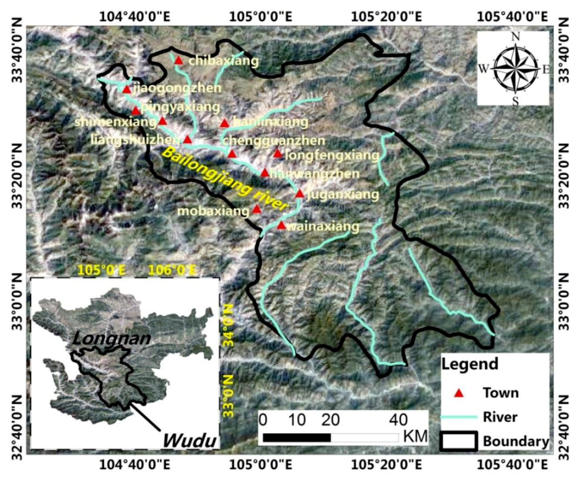
2.1. Study Area

Wudu District is located in southeastern Gansu Province, China and is situated along the middle reaches of the Bailongjiang River, a tributary of the Jialing River in the Yangtze River Basin. Its geographical coordinates are 32°47′~33°42′ N and 104°34′~105°38′ E (Figure 2). Wudu District is a debris flow-stricken area. According to incomplete statistics, the district has been affected by debris flow nearly 240 times [58], causing significant casualties and property losses. Field investigations [56] have indicated 172 debris flow gullies in the Zhouqu and Wudu districts along the middle reaches of the Bailongjiang River to form DFWSL areas of various sizes. Eighty-six of these are scattered from the Shawan section to the Gushuizi section, with a total acreage of 2550.91 hm2. The number of DFWSL areas on the left bank is 52, with an area of 1619 hm2; the other 34 have formed on the right bank, covering a total area of 931.91 hm2. The largest debris flow accumulation fan in this section is the Gouba fan, with a maximum width of 2.3 km and a maximum length of 2.4 km, to cover a total area of 3.01 km2. Fifty-nine DFWSLs exist from the Gushuizi section to the Bikou section and cover a total area of 155.99 hm2. Of these, 33 DFWSL areas are found on the left bank and 26 on the right back, covering 75.64 hm2 and 8.35 hm2, respectively. The single largest DFWSL area in this section, the Jugan DFWSL, is about 410 m wide and 650 m long, with an area of about 15.89 hm2. The smallest, the Yangsiba debris flow land, is 100 m long, 80 m wide, and 0.32 hm2 in area. According to preliminary data, exploited areas of the Bailongjiang River basin total 2808.2 hm2, accounting for 93% of the flat area.
Cinnamon soil, entisol, loessial soil, and rocky soil (soil classification is based on the World Reference Base) are the four main soil types in Wudu District. Cinnamon soil and entisol are mainly distributed in valley terraces with low altitudes. The two soils are high yield soil types because of moderate texture and high potential fertility. Grain crops include corn, wheat, potato and rapeseed, while economic crops include vegetables, watermelons, olives, Chinese prickly ash, and grapes. The local economy of Wudu District mainly thrives on the sale of crops such as olives, peppers, grapes, potatoes, and canola. According to a year-long field investigation, the olive yield is about 2250 kg per ha and the purchase price is about 10 CNY/kg. Thus, income is about CNY 22,500/ha. The Chinese prickly ash yield is about 750 kg per ha with a purchase price of about 100 yuan/kg, providing an income about CNY 75,000 per ha. The rapeseed yield is about 2250~3000 kg per ha and its purchase price is about CNY 4 /kg, yielding an income per ha of about CNY 9000–12,000. The potato yield is about 600 kg per ha, its purchase price is about CNY 2/kg, and the income per ha is about CNY 1200.
At present, apart from farmland and forests, the DFWSL areas in Wudu District have also been transformed into construction land and township development sites where site conditions are appropriate (Figure 3).

2.2. Data Collection and Methodology

Satellite remote sensing has been proven to be a suitable approach for detecting and monitoring land use transformations [59]. This study used land use raster data with a spatial resolution of 1 km to study land use changes in the Wudu District in 2005, 2010, and 2015 (Table 1 and Table 2, Figure 3). A 2.15 m (no deviation) resolution image of Chenjiaba village in 2014, and again 2017, was obtained from Google Maps. The images were digitized using ArcGIS 9.3. The features in the area were divided into four categories by visual interpretation: Cultivated land, woodland, water, and construction land (Figure 4). Furthermore, the land area was constructed as a land use transfer matrix (Table 3, Table 4 and Table 5) using the method of Braimoh [60]. Additionally, the current situation and changes of various land use types were quantitatively analyzed. To quantitatively characterize the rate of land use change in the study area within a given time interval, the dynamic degree of land use was used [21]. It is described as follows:
K = U 2 U 1 U 1 × 1 T × 100 %
where K is the dynamic degree of land use; U1 and U2 are the area of a land type at the beginning and the end of a period, respectively; and T is time interval (years). This equation can be used to analyze and compare the rates of change among different land use types in the study area.

3. Results

3.1. Temporal and Spatial Patterns of Land Use Transformation in DFWSL

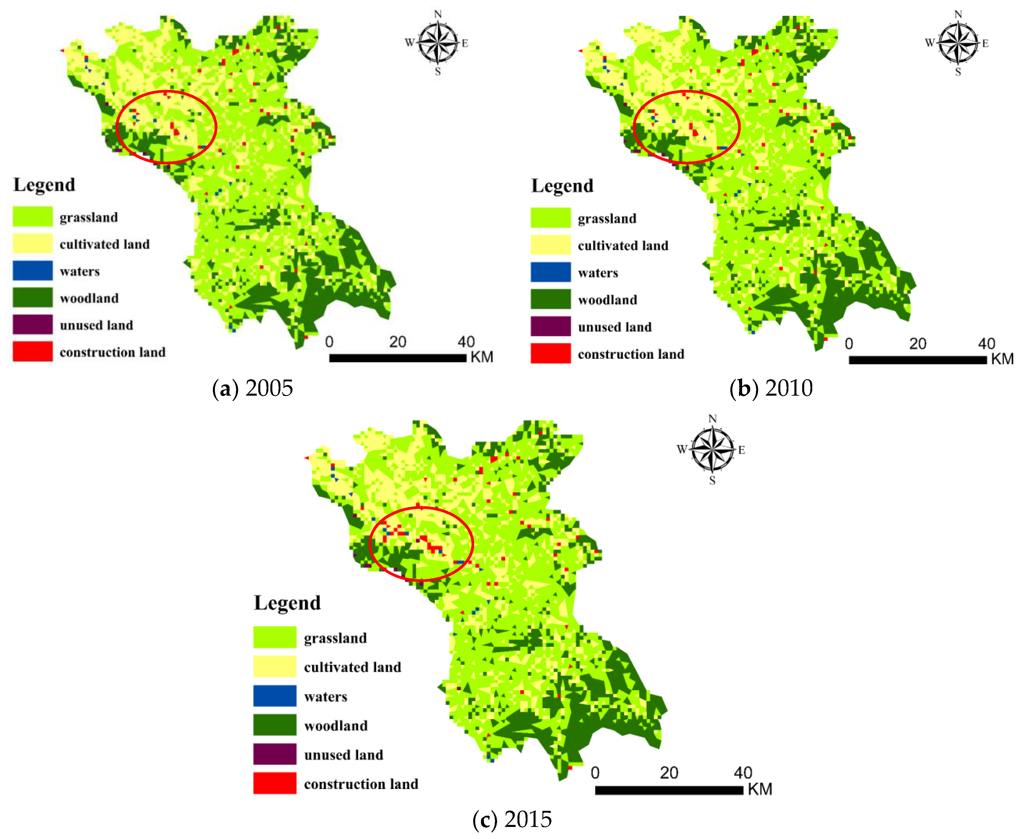
3.1.1. Overall Conditions of Land Use Transformation in Wudu District

The distribution of land use types in Wudu District, according to the classified remote sensing images is shown in Figure 4; the ratios are shown in Table 1. Wudu District has developed along the Bailongjiang River and belongs to the mountain-valley land type. The land use pattern in mountainous areas is limited by site conditions and the climate. The middle and high mountain areas are dominated by grasslands and woodlands, which accounted for about 52% and 22% of the total area, respectively. The lowland flat areas, mainly constituted cultivated land and accounted for about 24% of the total area (Table 1). The transformation in land use types from 2005 to 2015 (Table 2) suggests that the area of cultivated land has decreased (a decrease of 36.5395 km2 from 2005 to 2015) and transformation to other land types has largely shown an increasing trend.
In particular, after 2010, the growth rate of construction land was at its highest, showing an increase of 13.8533 km2 from2005 to 2015 to account for 25.64% of the total construction land. The growth rate of construction land from 2010 to 2015 was 6.87%, while the growth rate from 2005 to 2010 was only 0.11%. This rate brought about an increase in the area of construction land, which can also be verified from the number of patches indicated by red circles in Figure 4.
To illustrate the mutual transformation of land types on DFWSL and clear land transformation trends, and analyze the spatial-temporal change patterns of DFWSL [61], ArcGIS was used to calculate matrices of land use transformation from 2005 to 2010 and from 2010 to 2015 (Table 3 and Table 4).
As indicated in Table 3, the overall change from 2005 to 2010 was slight and represented by transfer-ins and transfer-outs of cultivated land, with transfer-outs outnumbering transfer-ins. Nearly 10.4233 km2 of the cultivated land was converted into grassland, 1.2984 km2 into woodland, and a very small part (0.3791 km2) was converted into water area, totaling 12.1001 km2. The transfer-ins were mainly from grasslands, which accounted for 4.2508 km2. The remaining areas were converted from woodland and water, which accounted for 0.2137 km2 and 0.0299 km2, respectively. As a result of the transformation progress, the cultivated land outflowed to other land types with a net outflow of 7.6063 km2.
A comparison of results from 2010 to 2015 (Table 4) with those from 2005 to 2010 indicates that although the decrease of arable land was still the prevailing trend, an increase in either the total quantity or transformation rate was more prominent. Although the outflow of arable land was still dominated by grassland (15.4292 km2), the outflow to woodland, water, and unused land increased exponentially from 2005 to 2010. Additionally, the area of arable land transforming to construction land significantly increased. It surged from near zero in 2010 to 13.998 km2 in 2015 and the increased acreage accounted for 34.80% of the acreage of construction land in 2010.

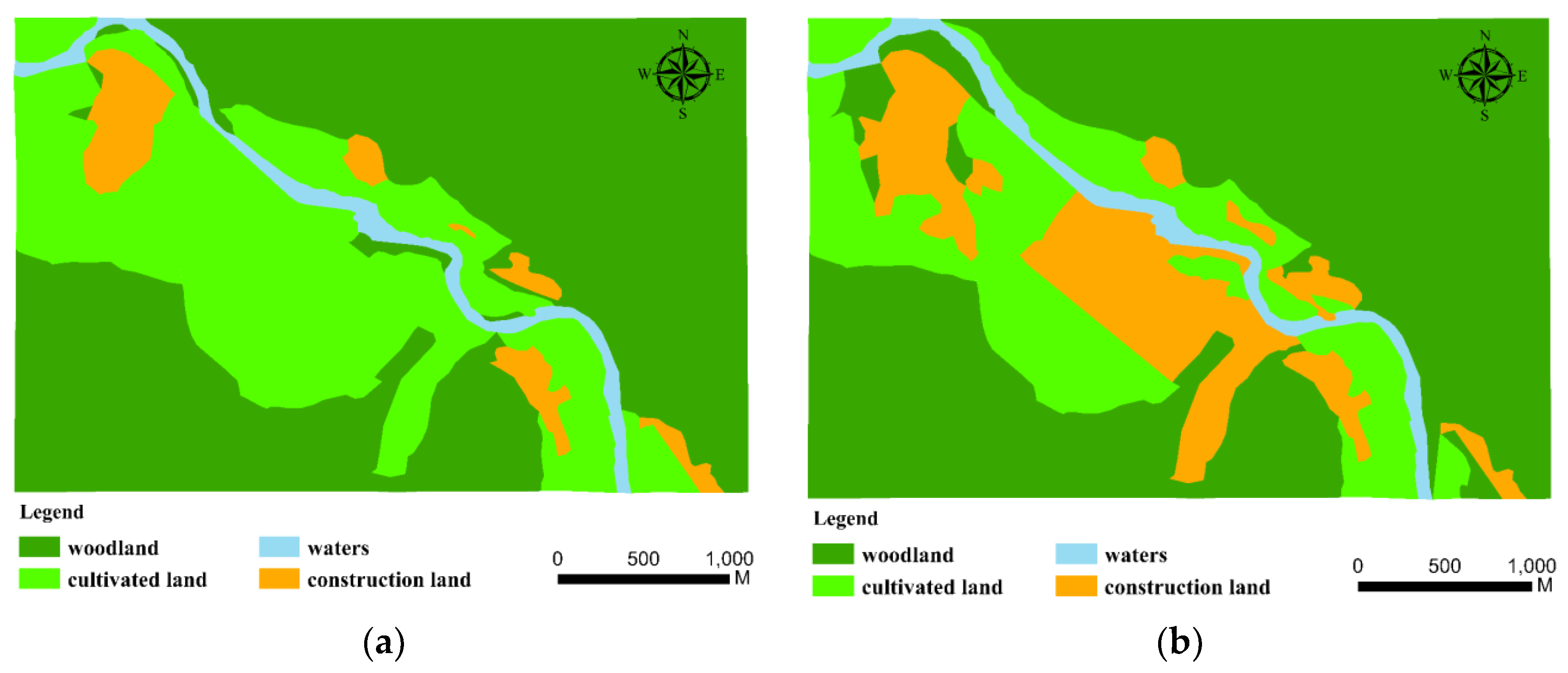
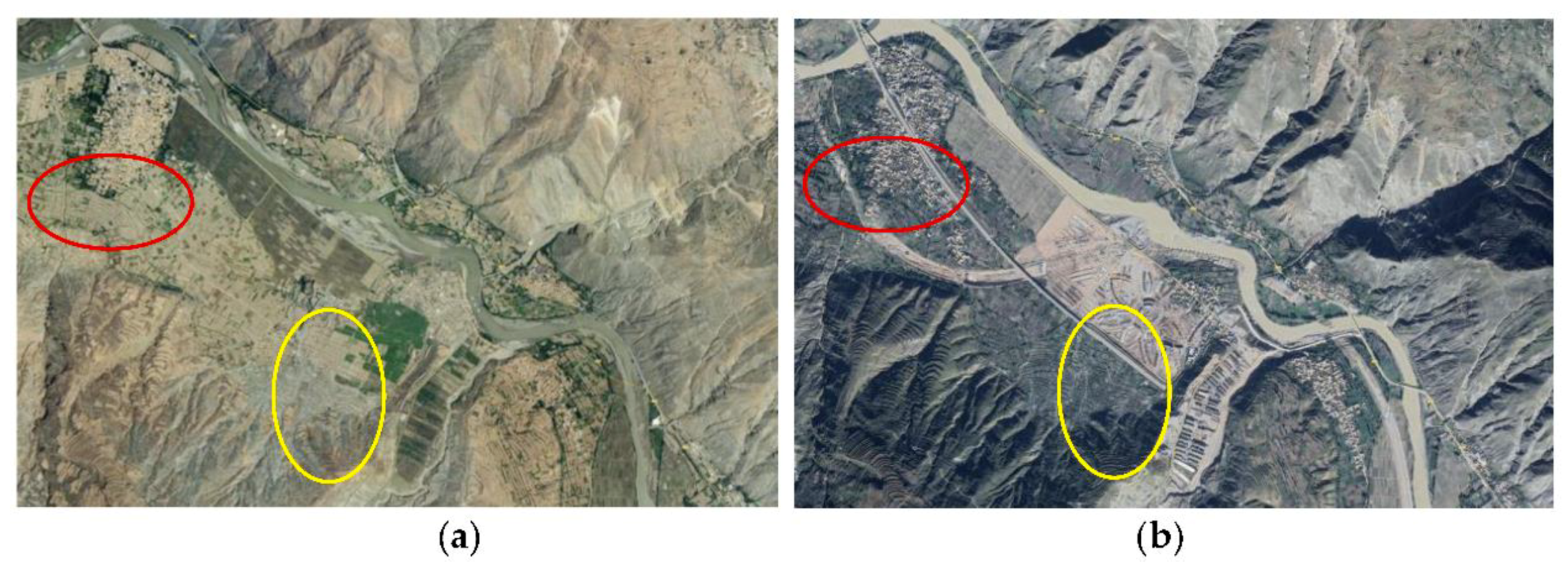
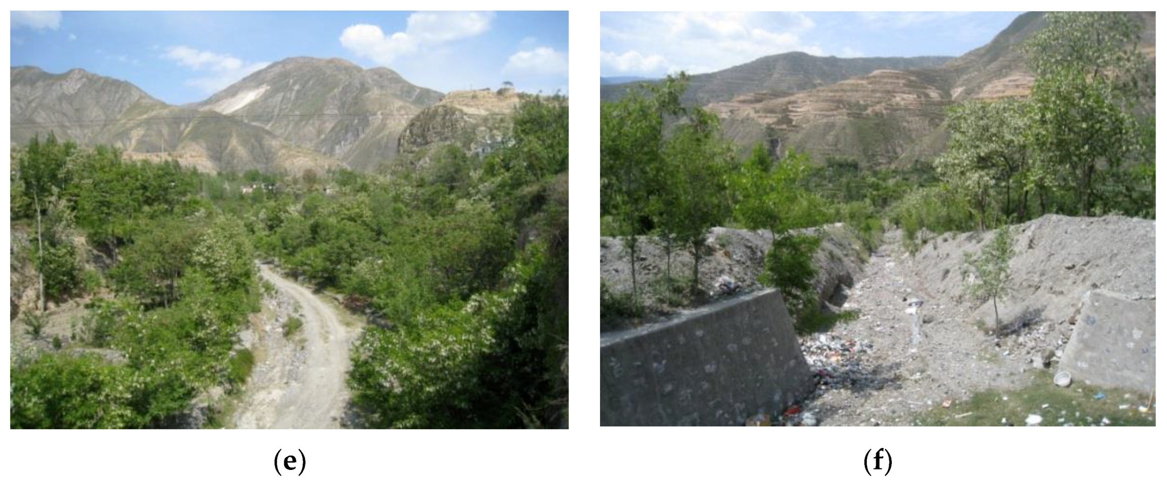
3.1.2. Land Use and Transformation in a Typical DFWSL

To illustrate the land use transformation of DFWSL, this study narrowed its study scope by selecting Chenjiaba village as a research site. Chenjiaba village is completely constructed on converted DFWSL (Figure 5). Land use maps for 2014 and 2017 were selected, together with Google images (Figure 6); an analysis was conducted in terms of land use and transformation. As shown in Figure 5, in 2014 the DFWSL in the village was mainly developed into cultivated land and a small area of construction land. However, in 2017, most of the cultivated land had outflowed and transformed into construction land, which significantly increased the acreage of construction land. Figure 5 shows detailed land use and transformation trends in 2014 (a) and 2017 (b).
The DFWSL developed along the riverside showed features of flat terrain, abundant water and heat, and easy access to traffic. Therefore, the use of this land is goal-oriented and well targeted. Woodlands were transformed into artificial forests for growing economic crops, such as olives; and some were also converted into arable land. Before 2014, woodland and arable land accounted for 92.06% of the land in the village. In 2017, the woodland remained largely unchanged. However, almost a third of the arable land resources outflowed and transformed into construction land, which tripled the percentage of construction land from 4.6% to 14.59% (Table 5). As a representative of the DFWSL use and transformation model of the Bailongjiang River Basin, the pattern of land transformation in Chenjiaba village reflects the trend of conversion of land use type. Most of the arable land in Wudu District was transformed from DFWSL along the river. Therefore, the increased construction land was transformed from DFWSL in the low-relief terrain.

3.2. Driving Forces of Land Use and Land Changes of DFWSL

Traditional geography focuses on morphology and patterns and pays little attention to underlying processes, especially the influences of patterns on the process. Therefore, this study revealed the underlying factors driving DFWSL use and transformation through change patterns.

3.2.1. Natural Driving Forces

DFWSL areas are located in the active debris flow area. They are extremely sensitive to vulnerable habitats and easily prone to natural disasters. Therefore, land use and changes of DFWSL in Wudu District resulted from debris flows and earthquakes. The annual precipitation in Wudu District is relatively large and the temporal and spatial distributions are uneven. Precipitation is largely in the form of heavy and torrential rains that often occur from May to September. The rainfall during this period accounts for 79.2% of the whole year. Since 1951, heavy rains with daily precipitation of over 25 mm has occurred on average 2.7 times per year; daily precipitation of over 50 mm has occurred once per year. In the past 20 years, the number of heavy and torrential rain events has increased significantly; for example, extremely heavy rainstorm events occur on average 4.3 times a year. Each event exceeds the criticality for debris flows. According to data from the meteorological department, in the event of torrential rains, intensity exceeds 8 mm within 10 min.
According to historical records, in Houba village, Wudu District, large-scale debris flows have occurred five times, in 1956, 1967, 1984, 1998 [62], and 2005. Moreover, on 21 June 2006, the village was struck by a 5.0 magnitude earthquake with an epicenter at 105° E, and 33.1° N. This earthquake adversely impacted the Niwangou gully and banks. The village was also affected by the Wenchuan earthquake which occurred in Sichuan on 12 May, 2008. Parts of Niwangou gully collapsed and mudslides blocked the gully while cracks were widened. The most serious blockages happened in the middle and lower reaches of the Niwangou gully, where slumps from both sides of the gully bank silted up the trench. The volume of debris flow from solid loose material was about 20 × 104 m3.
Houba village is built on the DFWSL and contains 520 households with a total of 2600 residents. Five large-scale mudslides have occurred (i.e., those in 1956, 1967, 1984, 1998, and 2005); these destroyed more than 50 private residences and over 150 acres of farmland, burying 15 livestock, damaging a 200 m streth of long state highway, and resulting in direct economic losses of more than CNY 4.20 million. The damaged houses could not be reconstructed on the original sites and the buried farmlands were unsuitable for cultivation over a short period of time. For these reasons, these lands were developed into woodland, which increased water and soil conservation. In summary, frequent natural disasters have caused uncertainties in the use of DFWSL.
The frequent occurrence of debris flow hazards in the Wudu District is closely related to the condition of soil and vegetation in the area. The middle-high mountains mainly consist of loessial and rocky soils. They belong to entisol, with a large quantity of gravel, and their structure is loose. There is almost no bedrock distribution, suggesting that the soil is unstable and highly erodible. In addition, the vegetation in the area is unevenly distributed, with forests as the main type. The vegetation coverage at an altitude of 1800 m is less than 50%. The vegetation at 1400 m altitude comprises various grasses with a coverage rate of less than 20%. The vegetation coverage in the valleys on both sides of the mainstream of the Bailongjiang River (debris flow beach concentrated area) is low (NDVI < 0.3). Within this range, the capacity of the vegetation to retain water and soil is poor; therefore, it is prone to mudslides. About 65.53% of the total area is a high-risk mudslide-intensive area [63]. In summary, the harsh environment of the underlying surface cannot withstand natural disasters; this results in frequent changes in land use in the debris flow area.
Land use in the debris flow area, especially the development and use of DFWSL, is initially cultivated land, woodlands, or construction land and is largely dependent on the presence of frequent and catastrophic mudslides. If land is relatively stable with good site conditions, it will be developed into construction or arable land; otherwise, it will be converted into woodland in order to preserve water and soil. This is very different from the choice of land use types in ecologically non-vulnerable areas. In general, the development of ecologically non-vulnerable areas assumes that the impacts of natural disasters are non-existent or negligible because the priority is to balance economic benefits and ecological conservation. Therefore, in the debris flow active area, land use and transformation are strongly affected by natural factors, which significantly impact land planning, resource management, and risk control.

3.2.2. Characteristics of Land Transformation and Demographic Migration

According to the Regional Statistical Yearbook (Wudu district), the population was 530,000 in 2005, 544,480 in 2010, and 592,000 in 2015 indicating a growing trend, especially from 2010 to 2015. Along with population growth, land use and transformation also changed across the same period [64]. From 2010 to 2015, woodland and construction land noticeably increased while cultivated land decreased. This change was brought about by transformation of land use of the DFWSL along the river. Only a small region in the middle-high mountainous area was affected by mudslides; because the underlying surface in this area is seldom affected, there remain largely unchanged land types. Moreover, owing to different topographies, construction land and cultivated land underwent few changes.
To understand the correlation between population growth and the use and transformation of DFWSL, the population of Chenjiaba village (a village completely built on DFWSL in Wudu District) from 2005 to 2015 was assessed. The population was close to 300 in 2005, and had increased to 560 in 2010, and 1156 in 2015. Land use and transformation in Chenjiaba village were characterized by the outflow of cultivated land to construction land (Figure 5 and Figure 6). The relationship between population and land use and transformation is as follows: A negative correlation between population growth and the reduction of arable land was observed while the correlation between population growth and an increase in construction land was positive. The growth of the population in Chenjiaba village was due to inward migration of people from Pingya village, which is located in the middle-high mountains. Therefore, the land originally used for residential areas was converted to forests, grasslands or cultivated land in Pingya village. Consequently, land transformation conditions in Pingya village were the opposite to those in Chenjiaba village.
Therefore, the relationship between land transformation and population change results from the impact of population distribution on land use. Population distribution and land use type changes are also affected by scale and range. At large scales, they may not be related while at small and medium scales, local population changes will lead to distinctive changes in land use.

3.2.3. Changes in Land Use Policies and Strategies

Anthropogenic activity and regional development profoundly influence ecosystems and land use patterns [65]. According to the Regional Land Resources Bulletin (Wudu district), since the implementation of the policy of returning farmland to forests in 1999, China has attached great importance to the recovery of forests and, in particular, the recovery of ecologically fragile areas. The forest areas in Wudu District increased from 2005 to 2015. Additionally, China implemented the policy of “direct subsidies to grain producers” in 2004, canceled agricultural taxes in 2005, issued farmland protection funds in 2009, and has gradually provided skills training to rural laborers. The implementation of these policies has promoted the development and use of DFWSL to turn unavailable land into useful land resources. At present, in response to the initiative of rural revitalization [66] and the country’s poverty alleviation policies, the development and use of DFWSL is approaching the goal of building a nation that boasts “productive and compact producing spaces, comfortable and cozy living spaces, and picturesque ecological scenes” [67].
The period from 2016 to 2020 is a decisive stage for China with regard to building a moderately prosperous society. Poverty alleviation has been the focus of rural construction work in recent years. Although the amount of traditional arable land continues to decrease, recent years have witnessed the effective adjustment of agricultural structure and the industrial layout structure has begun to take shape. In particular, the adoption of intensive and efficient land use patterns for the cultivation of pepper, walnuts, olives, vegetables, and Chinese herbal medicines have been explored and modified through greenhouse agriculture and multi-dimensional eco-agriculture to significantly increase the income of farmers. In 2010, the household operating income of farmers in Wudu District reached CNY 1250 and reflected an increase of CNY 502 over that in 2005 (CNY 748). This is an average annual increase of 8.03% and accounts for 56.43% of total net income. Moreover, urbanization also provides a broader perspective for people to develop secondary and tertiary industries within their households, especially in the catering, transportation, traffic, and construction industries, all of which have not only provided employment for farmers but also increased farmer incomes. For example, the Lanyu railway and the Lanhai expressway have facilitated traffic in Wudu District. Moreover, the Hanwang 330 KV transformer substation has been completed and put into production, stimulating investment in exponential growth and subsequent industry development. At the same time, this substation also created employment and provided opportunities for increasing farmer incomes. The development of catering and real estate industries and increased traffic require more land which is often categorized as land for construction. Therefore, the acreage of construction land increased dramatically after 2010, and arable land decreased rapidly, especially in development-oriented areas (for example, the land near Chenjiaba, as shown in Figure 5 and Figure 6). The increased land for construction also includes space for various types of infrastructure such as drainage systems and blockage measures.
In summary, in the area where mudslides occurred, the country’s policies or strategies in different periods influenced the diversity of certain types of land use; however, the complete transformation of one land type to another could not be determined. For any country or region, land use should comply with the overall standards of being “safe, harmonious, open, coordinated, competitive, sustainable, and beautiful”. This highlights the difference between the influence of policy or strategy and natural factors on land use and transformation. In general, natural driving forces can promote complete transformation of land use types, while policy or strategy does not play a decisive role in the transformation.

4. Discussion

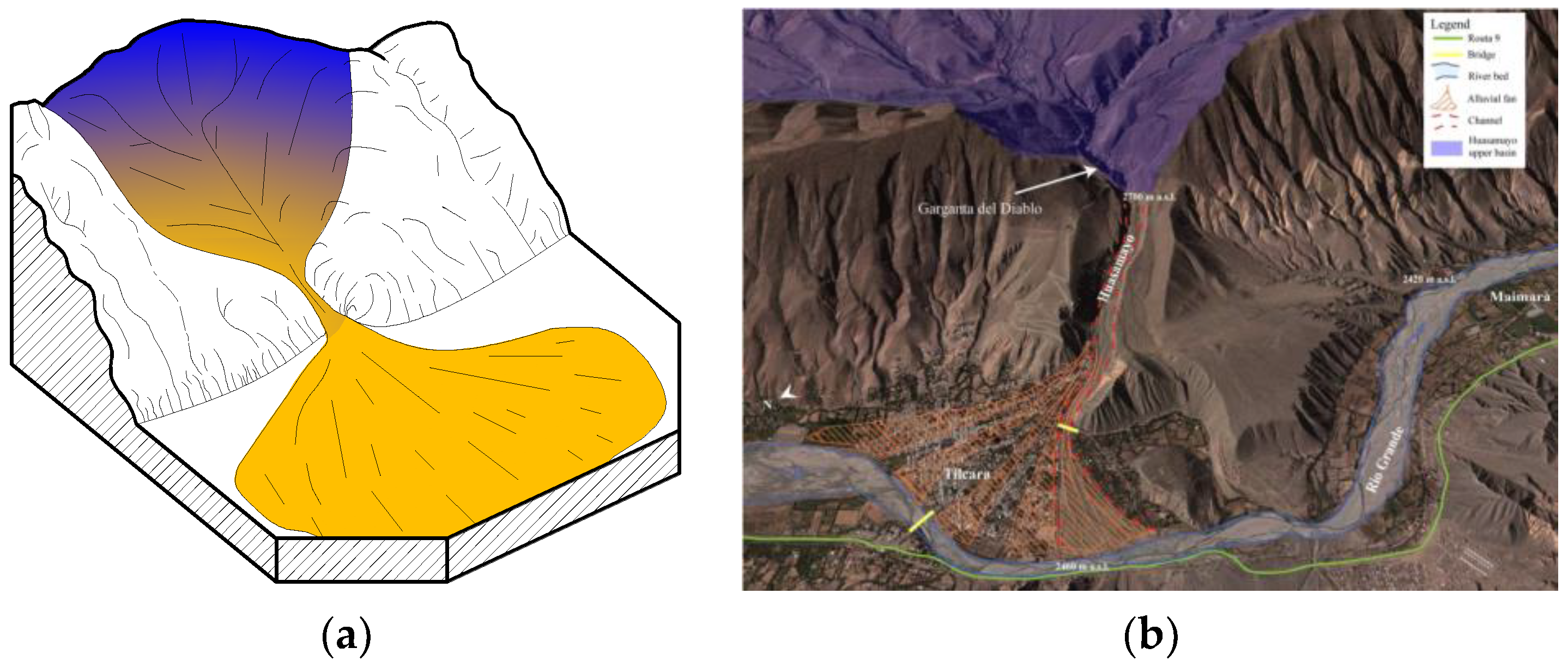
4.1. A Comparison between Our Study and Other Similar Area

The Pokhara valley is an intermountain fluvial basin occupying the midsection of the Seti River in the Lesser Himalayas of Nepal. It holds a large volume of layered clastic deposits of gravel, silt and clay of Quaternary age [68,69]. This area, like Wudu, is located in an ecologically fragile area and is subject to frequent landslides and debris flow. Both these areas are sensitive to natural factors and human influence. The land cover changes are characterized by increses in construction land. In addition, land use structure is becoming increasingly diverse, expanding to include not only construction and forest land, but also water areas and grassland. At present, much of the city’s rapid growth in population has been accommodated in temporary settlements that are at high risk of environmental impairments and hazards in Pokhara [70]. However, Wudu district has adopted a more rational settlement for population growth for example, moving people away from danger zones to a safe area (Pingya village to Chenjiaba village, as shown in our study). Furthermore, in Wudu district, in addition to land use and land use changes, emphasis is also placed on the measures to conserve soil and water and ecological protection (Figure 7), such as cultivating vegetation for slope protection (Figure 7a,b), and geotechnical engineering (Figure 7c,d).
In recent years, marginal lands have attracted widespread concern due to their potential for exploitation [71,72]. Caserta [73] highlighted that this is likely because many abandoned regions have latent resources of water, energy, and vegetation (e.g., commercial agriculture) which, if properly exploited, could lead to a flourishing modern rural system. It is worth mentioning that the Wudu district pays more attention to maximizing the efficiency of land resources use. Debris flow waste-shoal lands are developed into available land without disrupting the natural environment. While the objectives and ultimate aim of reclamation may differ in the face of individual needs and natural conditions, the essential ideas remain the same: Take ecological restoration and construction as the main lines, pursue the maximization of economic and social benefits from land and achieve sustainable development. Hence, although Wudu is in the debris flow area and experiences fast land use transformation, the risks from natural disasters are also accounted for in the form of corresponding prevention and control measures.

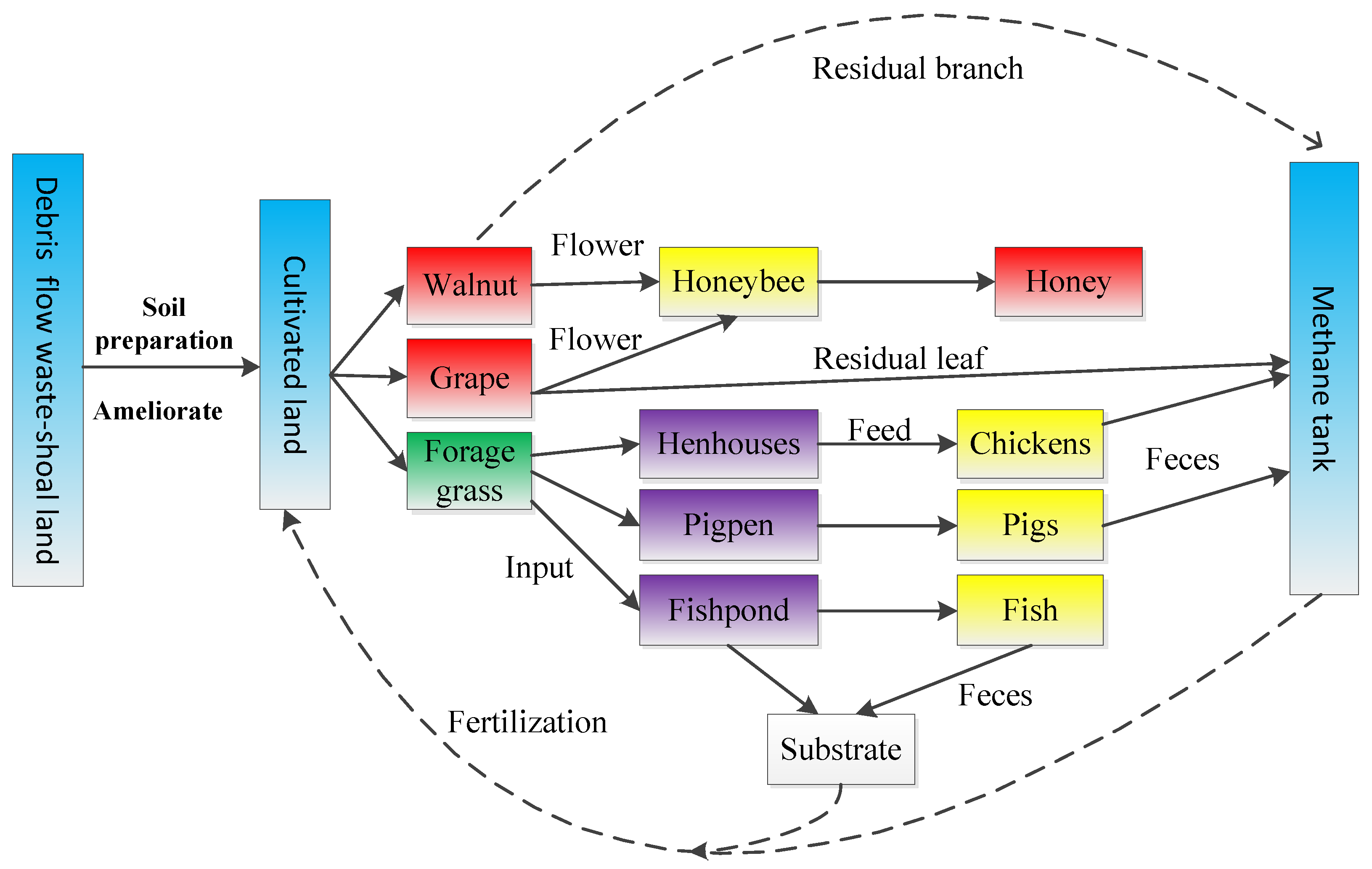
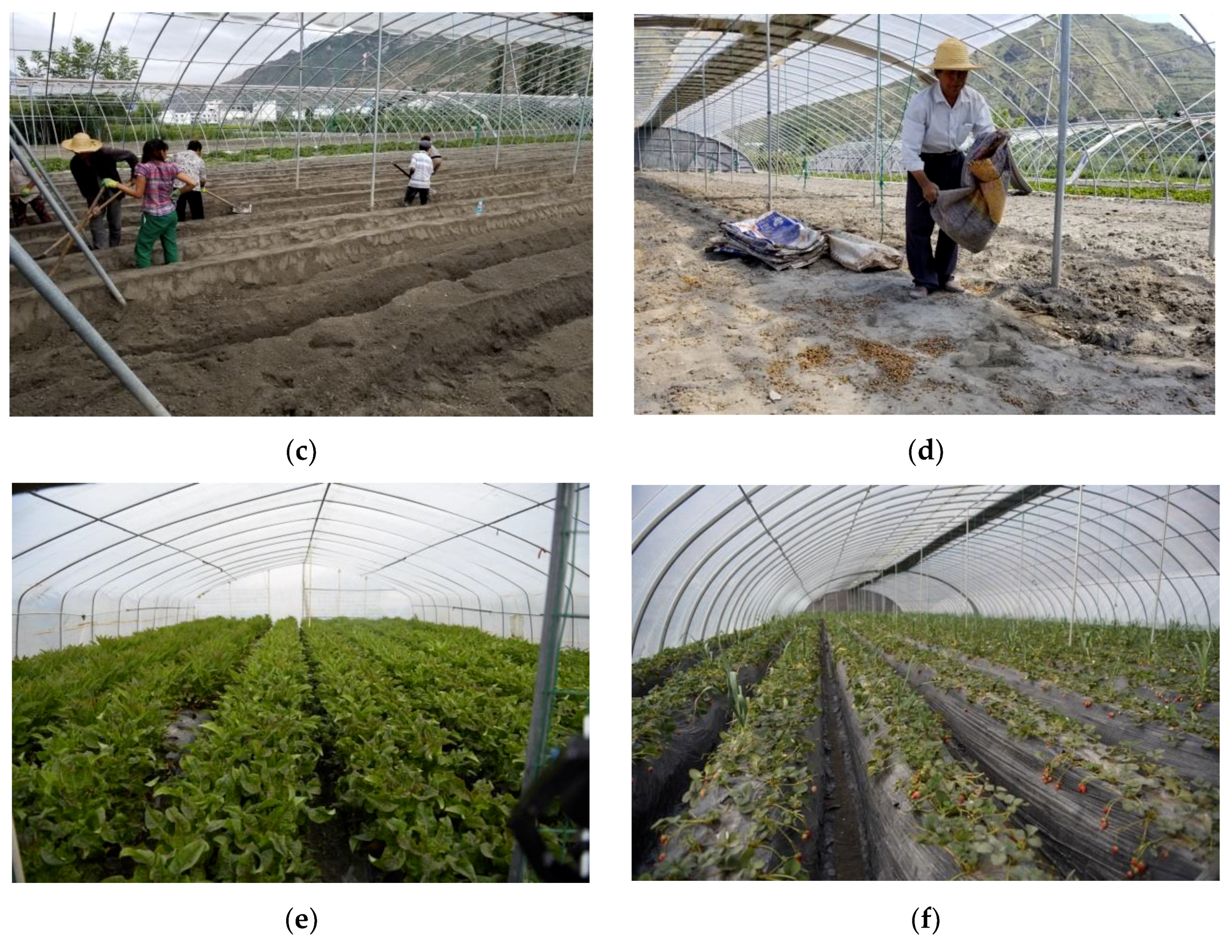
4.2. Development Mode Based on Local Conditions

Moving out of environmentally fragile areas where the environment is harsh and disasters occur frequently is a common sentiment. China is a mountainous country with a large population. The mountainous area accounts for two-thirds of the country’s total land and population in these areas exceeds 1.3 billion. Since abandoning these places is unlikely, it is beneficial to take advantage of unique mountainous resources. Although debris flows cause significant damage and losses to the natural environment and humans alike, fans shaped by debris flows are advantageous for human development. At present, there are two types of development models worth recommending: Greenhouse agriculture and multi-dimensional eco-agriculture.
Considering the climate of Wudu District and its site conditions, efficient multi-dimensional eco-agriculture has resulted in intercropping of olives, grapes, walnuts, and pasture to utilize different levels of photothermal resources. It has also equipped the region with supporting facilities such as reservoirs, irrigation systems, pig houses, chicken houses, and biogas digesters. Forage is used as feed for chickens, pigs, and fish; the manure of livestock, branches and leaves of walnuts and grapes, and branches of crops can be added to biogas digesters for fermentation; the biogas produced can be used as energy and the remaining waste can be used as fertilizer; the deposits of fish ponds can be used as fertilizer for plant and crops; and the flowers of walnut and grape crops can be used for honey-making during the flowering period (Figure 8). This model, through the recycling of materials and energy flows, forms a number of intertwined industrial chains and organically links the biological environment within the multi-dimensional agricultural system. It is also likely to promote agricultural tourism such as flower viewing in spring and fruit gathering in autumn. Certain locations may also have the potential to develop rural tourism and operate farm stays. Booming rural tourism can increase consumption of green foods and encourage more farmers to embrace three-dimensional agriculture, and finally, build a desirable development situation. Primary industry boosts tertiary industry, which in return can promote the development of agriculture.
Greenhouse agriculture adopts precise operating and large-scale planting methods. It helps utilize the flat terrain and sufficient water sources to plant non-seasonal fruits and vegetables (Figure 9). Wudu’s greenhouse vegetables adjust to market demand and farmers mainly plant white leaf mustard, lettuce, and strawberries. A 2 hm2 area of land in the Liangshui town of Wudu District has an annual production value of CNY 450,000 per ha. It not only provides employment for local residents, but also increases their income by CNY 20,000–30,000 per year. At the same time, greenhouse agriculture is pollution-free (as it replaces chemical fertilizers with soybeans, which are highly nutritious), and high-tech; for example, using plant sterilization technology such as the garlic bactericidal method and the use of biological insecticides (introducing Neoseiulus californicus (Acari: Phytoseiidae) to get rid of red spiders in fruit sheds). Such measures have greatly reduced environmental pollution and improved the taste and safety of vegetables and fruits. Therefore, the two types of development models are worth promoting and developing.

4.3. Relationship between Population Change and Land Use and Transformation

Different schools of thought exist regarding the relationship between population growth and land use type transformation. One opinion is that population increase is directly related to the change in the quantity of woodland and cultivated land. For example, population growth leads to a reduction in tropical forests [74,75] and an increase in the demand for arable land, thus causing excessive reclamation of agricultural land, serious land degradation, and related environmental problems [76]. As urbanization proceeds, population growth can cause a sharp decline in the quantity of arable land and an increase in the quantity of construction land [77]. Another opinion is that the increase in population is not related to land use or transformation; in particular, there is no obvious correlation between population growth and the increase or decrease in woodland and cultivated land [78]. Zhu [79] studied land use changes in areas surrounding the Bohai region of China and found that population growth did not lead to any increase in cultivated land from 1985 to 1995.
The development and use of DFWSL, especially for newly formed lands, are subject to fluctuations due to their instability and vulnerability. Land use type changes are greatly affected by natural disasters. For instance, a flat DFWSL might be used as arable land or construction land; however, owing to certain risks, it must instead be used as water and soil conservation forest. Areas seldom affected by natural conditions are often subject to greater volatility due to strategic policies [70,80]. Under these conditions, woodland is transformed into cultivated land, which is in turn transformed into construction land and may eventually become woodland or cultivated land. In mountainous areas, the growth and migration of populations are oriented to suitable and safe environments. Therefore, there is no direct and obvious correlation between the change of land-use type and population change in DFWSL. The complex relationship among them is co-determined by land use scales, policy shifts, and human decision-making. Based on our findings from the field investigation in the Wudu District, population growth leads to different population distributions that affect further development of land as cultivated land, woodland or construction land. For example, if the population in an area is concentrated and the land is resilient, the area may develop into residential areas and towns, while ecologically sensitive areas would be transformed into cultivated land or woodland. Therefore, changes in land use, especially changes in the quantity of arable land, may result in population increase, population decrease, or unchanged population, indicating no direct or universal correlation.

4.4. Limitations and Recommendations

Although the development and use of DFWSL areas have brought substantial ecological, economic, and social benefits to local farmers, certain limitations still exist. The location of the Wudu District in the gully region of the Loess Plateau, with the presence of mountains, rivers and ravines, frequent natural disasters, unfavorable temporal and spatial distributions of rainfall, and poor irrigation, have limited development and sustainability of agriculture, resulting in high cost and low income from agricultural production. Additionally, financial assistance is insufficient in Wudu District. Lack of investment and agricultural infrastructure, coupled with lack of knowledge and awareness of market competition among farmers, and the lack of new technology and systematic development, makes it difficult to popularize new crops. Although efficient multi-dimensional eco-agriculture and greenhouse technology have been promoted in some regions, current agricultural industrialization continues to lag. Channels for farmers to increase their incomes are not diversified; agricultural products remain at the roughly processed stage without packaging, thus making it challenging for farmers to increase their incomes.
To cope with these limitations, it is recommended to strengthen the construction of industrial bases, expand the scale of production, develop trade and export-oriented agriculture, and upgrade industrial production. It is also suggested that local governments continue the construction of leading industrial bases for fruits, vegetables and livestock, formulate construction standards for industrial bases, and focus on concentrated development. Furthermore, the government should provide support for agricultural cooperatives in terms of technical help, policy, and financial aid. For example, the government should help train various types of agricultural brokers who can give training and guidance to farmers and expand the scope of agriculture development. Additionally, the administration should actively explore new approaches of land circulation in accordance with the principle of “lawful, voluntary and paid” and modify policies to upgrade land circulation.
Local governments should also pursue brand strategies and promote unique local agriculture. The specialties of Wudu District, such as peppers and olives, need resource integration to dominate the market. Efforts should be made to accelerate the establishment and improvement of a standardization system for pollution-free agricultural products and organic foods. Additionally, the formulation and implementation of standards should be strengthened, while continuing to introduce new crop varieties and technologies, and to update knowledge. To help leading enterprises building brand awareness, an increase in investments and active participation in various agricultural product competitions must be encouraged. Winning awards and appraisal can improve the popularity of products. The government should also organize and coordinate the development of local agriculture. For example, the government should classify local specialties such as peppercorns, walnuts, and olives, integrate brands, increase production processing, adopt more technologies, and strengthen resource management.
The exploitation and protection of DFWSL are contradictory. In debris flow active areas, it is imperative to increase awareness and strengthen the ability for disaster prevention and relief. At the same time, it is significant to enhance cultural literacy, strictly observe conservation, and ensure rapid and sustainable socioeconomic development. With these two measures, an overall improvement in the economy, life quality, and environment can be achieved, and an ecological-economic comprehensive development zone can be built.

5. Conclusions

The development and use of DFWSL areas provide potential for relieving conflicts between humans and land in environmentally fragile mountainous areas and address the dilemma of land protection and sustainable development. This study was conducted in Wudu District, which is a typical model for the use of DFWSL. The trend of land use and transformation from 2005 to 2015 was analyzed and the results indicated that the land use type changes from 2005 to 2010 and from 2010 to 2015 was from cultivated land to grassland and construction land. However, the rate and scale of change between 2005 and 2010 were far lower than those during 2010–2015. Additionally, the conversion rate of cultivated land to construction land during 2010–2015 (6.87%) was more than 60 times that of 2005–2010 (0.11%). Finally, the area of construction land increased by 13.38533 km2 from 2005 to 2015, accounting for 25.64% of the entire construction land area.
Natural driving forces behind changes in land use type are natural disasters and include mudslides, landslides, and earthquakes, while anthropogenic factors are mainly the transformation of national policies and strategies. Moreover, in terms of land-use change in the debris flow area, the natural driving force has a decisive effect on the type of the initial development of DFWSL areas, while national policies or strategies in different periods only affect the direction of transformation in that specific period.

Author Contributions

S.H. and D.W. conceived and designed the framework of this article; S.H. and P.Z. collected and analyzed the data; All the authors contributed to the writing of this paper.

Funding

This work was supported by the National Natural Science Foundation of China (Grant No. 41790434) and the National Sci-tech Support Plan of China (2014BAL05B01).

Acknowledgments

We are grateful for the comments and criticisms of an early version of this manuscript by our colleagues and the journal’s reviewers.

Conflicts of Interest

The authors declare no conflict of interest.

References

  1. Fu, B. Ecosystem Services and Ecological Security; Higher Education Press: Beijing, China, 2013. [Google Scholar]
  2. Wang, X.; Bao, Y. Study on the methods of dynamic change of Land use. Adv. Geogr. 1999, 181, 81–87. [Google Scholar]
  3. Lesschen, J.P.; Verburg, P.H.; Staal, S.J. Statistical Methods for Analysing the Spatial Dimension of Changes in Land Use and Farming Systems; Wageningen University: Wageningen, The Netherlands, 2005. [Google Scholar]
  4. Chen, Y.; Yang, P. New progress in the study of land use/land cover change in the world. Econ. Geogr. 2001, 21, 95–100. [Google Scholar]
  5. Stern, P.C.; Young, O.R.; Druckman, D. Global Environmental Change: Understanding the Human Dimension; National Research Council: Washington, DC, USA, 1992. [Google Scholar]
  6. Tumer, B.L.; Meyer, W.B.; Skole, D.L. Global land use/land cover change: Toward an integrated program of study. Ambio 1994, 23, 91–95. [Google Scholar]
  7. Lawler, J.J.; Lewis, D.J.; Nelson, E.; Andrew, J.P.; Stephen, P.; John, C.; Withey, D.P.; Helmers, S.M.; Derric, P.; Volker, C.R. Projected land-use change impacts on ecosystem services in the United States. Proc. Natl. Acad. Sci. USA 2014, 111, 7492–7497. [Google Scholar] [CrossRef] [PubMed] [Green Version]
  8. Curebal, I.; Efe, R.; Soykan, A.; Sonmez, S. Impacts of anthropogenic factors on land degradation during the anthropocene in Turkey. J. Environ. Biol. 2015, 36, 51–58. [Google Scholar] [PubMed]
  9. Pan, H.; Deal, B.; Chen, Y.; Geoffrey, H. A Reassessment of urban structure and land-use patterns: Distance to CBD or network-based? Evidence from Chicago. Reg. Sci. Urban Econ. 2018, 70, 215–228. [Google Scholar] [CrossRef]
  10. Brovkin, V.; Boysen, L.; Arora, V.K.; Boisier, J.P.; Cadule, P.; Chini, L.; Claussen, M.; Friedlingstein, P.; Gayler, V.; van den Hurk, B.J.J.M.; et al. Effect of anthropogenic land-use and land-cover changes on climate and land carbon storage in CMIP5 projections for the twenty-first century. J. Clim. 2013, 26, 6859–6881. [Google Scholar] [CrossRef]
  11. Wu, K.Y.; Ye, X.Y.; Qi, Z.F.; Zhang, H. Impacts of land use/land cover change and socioeconomic development on regional ecosystem services: The case of fast-growing Hangzhou metropolitan area, China. Cities 2013, 31, 276–284. [Google Scholar] [CrossRef]
  12. Vanloocke, A. The Impact of Land-Use And Global Change on Water-Related Agro-Ecosystem Services in the Midwest US. Ph.D. Thesis, University of Illinois at Urbana–Champaign, Champaign, IL, USA, 2012. [Google Scholar]
  13. Luyssaert, S.; Jammet, M.; Stoy, P.C.; Stephan, E.; Julia, P.; Eric, C.; Galina, C.; Axel, D.; KarlHeinz, E.; Morgan, F.; et al. Land management and land-cover change have impacts of similar magnitude on surface temperature. Nat. Clim. Chang. 2014, 4, 389–393. [Google Scholar] [CrossRef] [Green Version]
  14. Turner, B.L.; Skole, D.; Sanderson, S.; Fischer, G.; Fresco, L.; Leemans, R. Land-Use and Land-Cover Change: Science/Research Plan; International Geosphere-Biosphere Programme: Stockholm, Sweden, 1995. [Google Scholar]
  15. Alexandratos, N.; Bruinsma, J. World Agriculture towards 2030/2050: The 2012 Revision; ESA Working paper Rome; FAO: Rome, Italy, 2012. [Google Scholar]
  16. Schmitz, C.; van Meijl, H.; Kyle, P.; Nelson, G.C.; Fujimori, S.; Gurgel, A.; Havlik, P.; Heyhoe, E.; d’Croz, D.M.; Popp, A.; et al. Land-use change trajectories up to 2050: Insights from a global agro-economic model comparison. Agric. Econ. 2014, 45, 69–84. [Google Scholar] [CrossRef]
  17. Bajzelj, B.; Richards, K.S.; Allwood, J.M.; Smith, P.; Dennis, J.S.; Curmi, E.; Gilligan, C.A. Importance of food-demand management for climate mitigation. Nat. Clim. Chang. 2014, 4, 924–929. [Google Scholar] [CrossRef]
  18. Benton, T.G.; Bailey, R.; Froggatt, A.; King, R.; Lee, B.; Wellesley, L. Designing sustainable landuse in a 1.5° world: The complexities of projecting multiple ecosystem services from land. Curr. Opin. Environ. Sustain. 2018, 31, 88–95. [Google Scholar] [CrossRef]
  19. Jiang, Z. Strategic framework for sustainable use of land resources in China. Rural Econ. Technol. 2003, 13–16, (In Chinese with English Abstract). [Google Scholar]
  20. Wang, X.H.; Zheng, D.; Shen, Y.C. Land use change and its driving forces on the Tibetan Plateau during 1990–2000. Catena 2008, 72, 56–66. [Google Scholar] [CrossRef]
  21. Li, X.Y.; Ma, Y.J.; Xu, H.Y.; Wang, J.H.; Zhang, D.S. Impact of landuse and land cover change on environmental degradation in Lake Qinghai watershed, northeast Qinghai-Tibet Plateau. Land Degrad. Dev. 2010, 20, 69–83. [Google Scholar] [CrossRef]
  22. Glasby, G.P. Sustainable development: The need for a new paradigm. Environ. Dev. Sustain. 2002, 4, 333–345. [Google Scholar] [CrossRef]
  23. Cao, S.; Liu, Y.; Yu, Z. China’s successes at combating desertification provide roadmap for other nations. Environ. Sci. Policy Sustain. Dev. 2018, 60, 16–24. [Google Scholar] [CrossRef]
  24. Liu, H.; Liu, Y.; Bi, R.; Xu, Y.; Wang, S. Reuse type judgment of mining wasteland based on land use competitiveness. Trans. Chin. Soc. Agric. Eng. 2016, 32, 258–266. [Google Scholar]
  25. Chen, T.T.; Peng, L.; Liu, S.Q.; Wang, Q. Land cover change in different altitudes of Guizhou-Guangxi karst mountain area, China: Patterns and drivers. J. Mt. Sci. 2017, 14. [Google Scholar] [CrossRef]
  26. Zhang, J.; He, C.; Chen, L.; Cao, X. Improving food security in China by taking advantage of marginal and degraded lands. J. Clean Prod. 2018, 171, 1020–1030. [Google Scholar] [CrossRef]
  27. Cai, Y. It is possible to turn unused land into construction land. Chin. Land 2010, 8, 27–31. [Google Scholar]
  28. Dorn, R.I. Desert rock coatings. In Geomorphology of Desert Environments; Springer: Dordrecht, The Netherlands, 2009; pp. 153–186. [Google Scholar]
  29. Frankel, K.; Dolan, J. Characterizing arid region alluvial fan roughness with airborne laser swath mapping digital topographic data. J. Geophys. Res. 2007, 112. [Google Scholar] [CrossRef]
  30. Blair, T.; McPherson, J. Processes and forms of alluvial fans. In Geomorphology of Desert Environments; Parsons, A., Abrahams, A., Eds.; Springer: New York, NY, USA, 2009; pp. 413–467. [Google Scholar]
  31. Marcato, G.; Bossi, G.; Rivelli, F.; Borgatti, L. Debris flood hazard documentation and mitigation on the Tilcara alluvial fan (Quebrada de Humahuaca, Jujuy province, North-West Argentina). Nat. Hazard Earth Syst. Sci. 2012, 12, 1873–1882. [Google Scholar] [CrossRef] [Green Version]
  32. Scheinert, C.; Wasklewicz, T.; Staley, D. Alluvial fan dynamics—Revisiting the field. Geogr. Compass 2012, 6, 752–775. [Google Scholar] [CrossRef]
  33. Blackwelder, E. Desert plains. J. Geol. 1931, 39, 133–140. [Google Scholar] [CrossRef]
  34. Bull, W.B. The alluvial fan environment. Prog. Phys. Geogr. 1977, 1, 222–270. [Google Scholar] [CrossRef]
  35. Tsujimoto, Y.; Inusah, B.; Katsura, K.; Fuseini, A.; Dogbe, W.; Zakaria, A.I.; Yoichi, F.; Masato, O.; Jun-Ichi, S. The effect of sulfur fertilization on rice yields and nitrogen use efficiency in a floodplain ecosystem of northern ghana. Field Crop Res. 2017, 211, 155–164. [Google Scholar] [CrossRef]
  36. Haas, T.D.; Densmore, A.L.; Stoffel, M.; Suwa, H.; Imaizumi, F.; Ballesteros-Cánovas, J.A.; Wasklewiczf, T. Avulsions and the spatio-temporal evolution of debris-flow fans. Earth Sci. Rev. 2018, 177, 53–57. [Google Scholar] [CrossRef]
  37. Staley, D.M.; Wasklewicz, T.A.; Blaszczynsky, J.S. Surficial patterns of debris-flow deposition on alluvial fans in Death Valley, CA using airborne laser swath mapping data. Geomorphology 2006, 74, 152–163. [Google Scholar] [CrossRef]
  38. Cavalli, M.; Marchi, L. Characterization of the surface morphology of an alpine alluvial fan using airborne LiDAR. Nat. Hazard Earth Syst. Sci. 2008, 8, 323–333. [Google Scholar] [CrossRef]
  39. Wang, D.; Cui, P.; Zhu, B.; Wei, F. Characteristics of High Sand flow and improvement of debris flow waste-shoal land in Jiangjia gully, Yunnan, China. Mt. Res. 2003, 6, 745–751. [Google Scholar]
  40. Bull, W.B. Geomorphology of Segmented Alluvial Fans in Western Fresno County, California; US Government Printing Office: Washington, DC, USA, 1964.
  41. Cui, P.; Ge, Y.; Zhuang, J.; Wang, D. Soil evolution features of debris flow waste-shoal land. J. Mt. Sci. 2009, 6, 181–188. [Google Scholar] [CrossRef]
  42. Sancho, C.; Pena, J.L.; Rivelli, F.; Rhodes, E.; Munoz, A. Geomorphological evolution of the Tilcara alluvial fan (Jujuy Province, NW Argentina): Tectonic implications and palaeoenvironmental considerations. J. South Am. Earth Sci. 2008, 26, 68–77. [Google Scholar] [CrossRef]
  43. Okunishi, K.; Suwa, H. Assessment of debris-flow hazards of alluvial fans. Nat. Hazards 2001, 23, 259–269. [Google Scholar] [CrossRef]
  44. Curry, G.N.; Koczberski, G.; Selwood, J. Cashing out, cashing in: Rural change on the south coast of Western Australia. Aust. Geogr. 2001, 32, 109–124. [Google Scholar] [CrossRef]
  45. Petit, S. The dimensions of land use change in rural landscapes: Lessons learnt from the GB Countryside Surveys. J. Environ. Manag. 2009, 90, 2851–2856. [Google Scholar] [CrossRef] [PubMed]
  46. Rudel, T.K. Tree farms: Driving forces and regional patterns in the global expansion of forest plantations. Land Use Policy 2009, 26, 545–550. [Google Scholar] [CrossRef]
  47. Poyatos, R.; Latron, J.; Llorens, P. Land use and land cover change after agricultural abandonment: The case of a Mediterranean mountain area (Catalan Pre-Pyrenees). Mt. Res. Dev. 2003, 23, 362–368. [Google Scholar] [CrossRef]
  48. Zhou, Z. Landscape changes in a rural area in China. Landsc. Urban Plan. 2000, 47, 33–38. [Google Scholar]
  49. Burgi, M.; Russell, E.W.B. Integrative methods to study landscape changes. Land Use Policy 2001, 18, 9–16. [Google Scholar] [CrossRef]
  50. Weng, Q.H. Land use change analysis in the Zhujiang Delta of China using satellite remote sensing, GIS and stochastic modeling. J. Environ. Manag. 2002, 64, 273–284. [Google Scholar] [CrossRef]
  51. Chen, L.D.; Messing, I.; Zhang, S.R.; Fu, B.J.; Ledin, S. Land use evaluation and scenario analysis towards sustainable planning on the Loess Plateau in China-case study in a small catchment. Catena 2003, 54, 303–316. [Google Scholar] [CrossRef]
  52. Lu, L.; Li, X.; Cheng, G.D. Landscape evolution in the middle Heihe River Basin of North-West China during the last decade. J. Arid Environ. 2003, 53, 395–408. [Google Scholar] [CrossRef]
  53. Jia, B.Q.; Zhang, Z.Q.; Ci, L.J.; Ren, Y.P.; Pan, B.R.; Zhang, Z. Oasis land-use dynamics and its influence on the oasis environment in Xinjiang, China. J. Arid Environ. 2004, 56, 11–26. [Google Scholar] [CrossRef]
  54. Zhao, H.L.; Zhao, X.Y.; Zhou, R.L.; Zhang, T.H.; Drake, S. Desertification processes due to heavy grazing in sandy rangeland, Inner Mongolia. J. Arid Environ. 2005, 62, 309–319. [Google Scholar] [CrossRef]
  55. Liu, J.; Huang, J.; Ou, G.; Fan, J. The developing potentiality of slope farmland on the alluvial fans of debris flow in the midstream of Bailongjiang River. Res. Soil Water Conserv. 2011, 18, 92–96. [Google Scholar]
  56. Future Earth. Future Earth 2025 Vision; Future Earth Interim Secretariat: Paris, France, 2014. [Google Scholar]
  57. Liu, Y. Strategies to Guarantee Land Resources Safety in China. Proc. Chin. Acad. Sci. 2006, 21, 379–384. [Google Scholar]
  58. Records of Wudu County, Gansu Province, China. In Compilation Committee of Local Records of Wudu County; Sanlian Bookstore: Beijing, China, 1998.
  59. Longley, P.A. Geography: Will development in urban remote sensing and GIS lead to better urban geography? Prog. Hum. Geogr. 2002, 26, 231–239. [Google Scholar] [CrossRef]
  60. Braimoh, A.K. Random and systematic land-cover transitions in northern Ghana. Agric. Ecosyst. Environ. 2006, 113, 254–263. [Google Scholar] [CrossRef]
  61. Wang, J.; Fu, B. The impact of land use on spatial and temporal distribution of soil moisture on the Loess Plateau. Acta Geogr. Sin. 2000, 55, 84–91. [Google Scholar]
  62. Huang, Z.; Yu, Y. Distribution and Developmental characteristics of debris flow in Longnan area of the Upper reaches in Yangtze River. People Yangtze River 1998, 29, 42–44. [Google Scholar]
  63. Ning, N.; Tian, L.; Zhang, P.; Qi, S.; Ma, J. Risk Assessment of debris flow in Wudu area, South Gansu Province, China. Mt. Res. 2013, 31, 601–609. [Google Scholar]
  64. Wang, D.; Meng, X.; Guo, P.; Guo, J.; Tan, L. Dynamic changes of land use before and after returning farmland to forest in Wudu, Gansu Province, China. Guizhou Agric. Sci. 2012, 40, 227–229. [Google Scholar]
  65. Nagashima, K.; Sands, R.; Whyte, A.G.D.; Bilek, E.M.; Nobukazu, N. Regional landscape change as a consequence of plantation forestry expansion: An example in the Nelson rejoin, New Zealand. For. Ecol. Manag. 2002, 163, 245–261. [Google Scholar] [CrossRef]
  66. Liu, Y.; Li, Y. Revitalize the world’s countryside. Nature 2017, 548, 275–277. [Google Scholar] [CrossRef] [PubMed] [Green Version]
  67. Shi, Z.; Deng, W.; Zhang, S. Spatio-temporal pattern changes of land space in hengduan mountains during 1990–2015. J. Geogr. Sci. 2018, 28, 529–542. [Google Scholar] [CrossRef]
  68. Yamanaka, H.; Yoshida, M.; Arita, K. Terrace landform and Quaternary deposit around Pokhara Valley, central Nepal. J. Nepal Geol. Soc. 1982, 2, 95–112. [Google Scholar]
  69. Gautam, P.; Panta, S.R.; Ando, H. Mapping of subsurface karst structure with gamma ray and electrical resistivity profiles: A case study from Pokhara valley, central Nepal. J. Appl. Geophys. 2000, 45, 97–110. [Google Scholar] [CrossRef]
  70. Rimal, B.; Baral, H.; Stork, N.; Kiran, P.; Sushila, R. Growing City and Rapid Land Use Transition: Assessing Multiple Hazards and Risks in the Pokhara Valley, Nepal. Land 2015, 4, 957–978. [Google Scholar] [CrossRef] [Green Version]
  71. Tilman, D.; Hill, J.; Lehman, C. Carbon-negative biofuels from low-input high-diversity grassland biomass. Science 2006, 314, 1598–1600. [Google Scholar] [CrossRef] [PubMed]
  72. Robertson, G.P.; Dale, V.H.; Doering, O.C.; Hamburg, S.P.; Melillo, J.M.; Wander, M.M.; Parton, W.J.; Adler, P.A.; Barney, J.N.; Cruse, R.M.; et al. Sustainable biofuels redux. Science 2008, 322, 49–50. [Google Scholar] [CrossRef] [PubMed]
  73. Caserta, G. Reclamation of abandoned lands in Mediterranean countries through the contribution of biomass and other renewable energy sources. A metodological proposal. In Proceedings of the Conference on Responsible Coastal Zone Management; 2000; pp. 275–280. Available online: https://www.researchgate.net/publication/295998952_Reclamation_of_abandoned_lands_in_Mediterranean_countries_through_the_contribution_of_biomass_and_other_renewable_energy_sources_A_metodological_proposal (accessed on 3 August 2018).
  74. Kammerbauer, J.; Ardon, C. Land use dynamics and landscape change pattern in a typical watershed in the hillside region of central Honduras. Agric. Ecosyst. Environ. 1999, 75, 93–100. [Google Scholar] [CrossRef]
  75. Verburg, P.H.; Veldkamp, T.A.; Bouma, J. Land use change under conditions of high population pressure: The case of Java. Glob. Environ. Chang. 1999, 9, 303–312. [Google Scholar] [CrossRef]
  76. Nemes, I. Land reclamation works applied in the amelioration perimeter in territorial agrarian fond otelec-uivar, Timiş County, Romania. Res. J. Agric. Sci. 2009, 41, 472–476. [Google Scholar]
  77. Xu, Y.; Tang, Q.; Fan, J.; Bennett, S.J.; Li, Y. Assessing construction land potential and its spatial pattern in china. Landsc. Urban. Plan. 2011, 103, 207–216. [Google Scholar] [CrossRef]
  78. Lambin, E.F.; Turner, B.L.; Geist, H.J.; Samuel, B.A.; Arild, A.; John, W.B.; Oliver, T.C.; Rodolfo, D.; Günther, F.; Carl, F.; et al. The causes of land-use and land-cover change: Moving beyond the myths. Glob. Environ. Chang. 2001, 11, 261–269. [Google Scholar] [CrossRef]
  79. Zhu, H.; He, S.; Zhang, M. Driving forces analysis of land use change in Bohai Rim. Geogr. Res. 2001, 20, 669–678. [Google Scholar]
  80. Deal, B.; Pan, H. Discerning and Addressing Environmental Failures in Policy Scenarios Using Planning Support System (PSS) Technologies. Sustainability 2016, 9, 13. [Google Scholar] [CrossRef]
Figure 1. Various debris flow fans. (a) The original debris flow fan; (b) Tilcara alluvial fan in Argentina [31].
Sustainability 10 02759 g001
Figure 2. Location of Wudu District.
Sustainability 10 02759 g002
Figure 3. Different types of debris flow waste-shoal lands use in Wudu District: (a) Primitive debris flow waste-shoal land; (b) overgrown with weeds; (c,d) developed into cultivated land; (e,f) villages or towns; and, (g,h) traffic network construction.
Sustainability 10 02759 g003
Figure 4. Distribution of land use types in Wudu District in (a) 2005, (b) 2010, and (c) 2015.
Sustainability 10 02759 g004
Figure 5. Land use and transformation maps of Chenjiaba village: (a) Status of land use type in 2014; (b) status of land use type in 2017.
Sustainability 10 02759 g005
Figure 6. Google images of land use transformation of DFWSL in Chenjiaba village: (a) Status of land use in 2014; (b) status of land use in 2017. Red circles represent arable land in 2014, most of which became construction land (residential area) in 2017; yellow circles show woodland (olive-planting sites) in 2014, which was converted into construction land in 2017.
Sustainability 10 02759 g006
Figure 7. Various measures for ecological preservation: (a,b) Slope ecological protection measures; (c,d) drainage groove with check dam; (e,f) ecological engineering protection in gully.
Sustainability 10 02759 g007aSustainability 10 02759 g007b
Figure 8. Operational route of multi-dimensional agricultural mode of DFWSL: Recycling of materials and energy flows.
Sustainability 10 02759 g008
Figure 9. Greenhouse agriculture on DFWSL: (a,b) exteriors of greenhouse on DFWSL; (c,d) land consolidation and fertilization; (e,f) vegetable (lettuce) and fruit (strawberry).
Sustainability 10 02759 g009
Table 1. Land use in Wudu District in 2005, 2010, and 2015.
Type200520102015
Acreage (km2)Ratio (%)Acreage (km2)Ratio (%)Acreage (km2)Ratio (%)
Grassland2388.88340.52182395.01280.52322406.37380.5257
Cultivated land1106.55830.24171098.95200.24001070.01880.2337
Woodland1018.35640.22231019.44100.22251020.55690.2228
Water15.42060.003415.76980.003416.46900.0036
Construction land40.17700.008840.22020.008854.03030.0118
Unused land8.40340.00188.40340.001810.35040.0023
Table 2. Area statistics on land use changes in Wudu District (km2).
Type2005201020152005–20102010–20152005–2015
Grassland2388.88342395.01282406.37386.129411.36117.4904
Cultivated land1106.55831098.9521070.0188−7.6063−28.9332−36.5395
Woodland1018.35641019.4411020.55691.08461.11592.2005
Water15.420615.769816.4690.34920.69921.0484
Construction land40.17740.220254.03030.043213.810113.8533
Unused land8.40348.403410.350401.9471.947
Table 3. Land uses transformation matrix for Wudu District from 2005 to 2010 (km2).
TypeGrasslandCultivated LandWoodlandWaterConstruction LandUnused Land2005
Grassland2384.44474.2508000.18802388.8834
Cultivated land10.42331094.45751.29840.3791001106.5583
Woodland00.21371018.14270001018.3564
Water00.0299015.39070015.4206
Construction land0.144900040.0322040.177
Unused land000008.40348.4034
20102395.01281098.95201019.441015.769840.22028.40344577.7992
Table 4. Land use transformation matrix for Wudu District from 2010 to 2015 (km2).
TypeGrasslandCultivated LandWoodlandWaterConstruction LandUnused Land2010
Grassland2389.12423.89060.816200.20710.97472395.0128
Cultivated land15.42921065.21592.39670.940013.99800.97221098.9520
Woodland1.82040.24671017.344000.029901019.4410
Water00.1809015.52900.0598015.7698
Construction land00.48470039.7355040.2202
Unused land000008.40348.4034
20152406.37381070.01881020.556916.469054.030310.35034577.7992
Table 5. Land use and transformation matrix of DFWSL in Chenjiaba village, Wudu District from 2014 to 2017 (km2).
TypeWoodlandCultivated LandWatersConstruction Land2014
Woodland6.86870.049470.039420.064287.0219
Cultivated land0.29282.379601.09813.7704
Waters00.00660.377600.3842
Construction land0000.54400.5440
20177.16152.43560.41701.706311.7205

