
Profile Development and Soil Properties of Three Forest Reclamations of Different Ages in Sokolov Mining Basin, Czech Republic

 , , and
Abstract
:1. Introduction
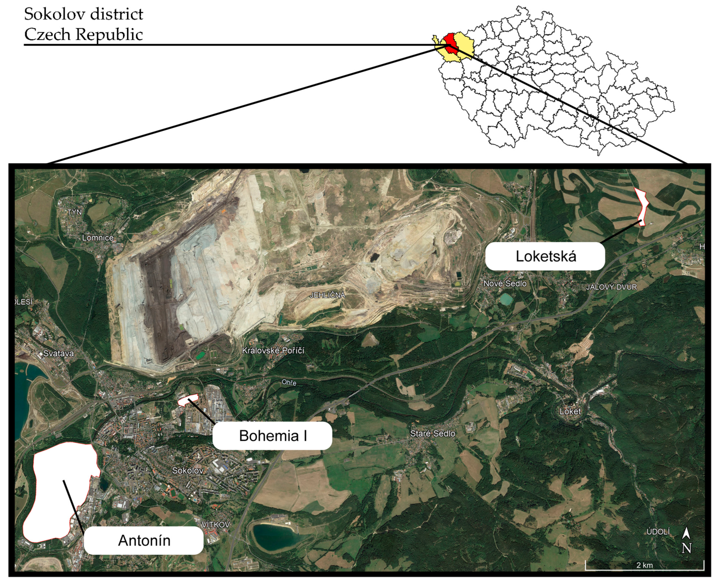
2. Materials and Methods
- Considering the alkaline clayey parent material and broadleaved vegetation cover in all locations, the soil type may tend to evolve from an anthropogenic mine Technosol to a forest Cambisol in this climate region;
- Reclamation time may strongly affect the development and thickness of formed horizons, as well as soil quality;
- The profiles positioned on the slopes may manifest somewhat poorer physical and chemical properties compared to their level terrain counterparts, due to the effects of surface runoff, surface and internal erosion processes, and lack of water logging.
3. Results
4. Discussion
5. Conclusions
Author Contributions
Funding
Data Availability Statement
Conflicts of Interest
References
- Hilson, G. An overview of land use conflicts in mining communities. Land Use Policy 2002, 19, 65–73. [Google Scholar] [CrossRef]
- Hendrychová, M.; Kabrna, M. An analysis of 200-year-long changes in a landscape affected by large-scale surface coal mining: History, present and future. Appl. Geogr. 2016, 74, 151–159. [Google Scholar] [CrossRef]
- Kuter, N. Reclamation of Degraded Landscapes due to Opencast Mining. In Advances in Landscape Architecture; IntechOpen: London, UK, 2013. [Google Scholar] [CrossRef]
- Svobodova, K.; Yellishetty, M.; Vojar, J. Coal mining in Australia: Understanding stakeholder knowledge of mining and mine rehabilitation. Energy Policy 2019, 126, 421–430. [Google Scholar] [CrossRef]
- Lima, A.T.; Mitchell, K.; O’Connell, D.W.; Verhoeven, J.; Van Cappellen, P. The legacy of surface mining: Remediation, restoration, reclamation and rehabilitation. Environ. Sci. Policy 2016, 66, 227–233. [Google Scholar] [CrossRef]
- Bell, L.C. Establishment of native ecosystems after mining—Australian experience across diverse biogeographic zones. Ecol. Eng. 2001, 17, 179–186. [Google Scholar] [CrossRef]
- Bradshaw, A.D.; Hüttl, R.F. Future minesite restoration involves a broader approach. Ecol. Eng. 2001, 17, 87–90. [Google Scholar] [CrossRef]
- Tropek, R.; Kadlec, T.; Hejda, M.; Kocarek, P.; Skuhrovec, J.; Malenovsky, I.; Vodka, S.; Spitzer, L.; Banar, P.; Konvicka, M. Technical reclamations are wasting the conservation potential of post-mining sites. A case study of black coal spoil dumps. Ecol. Eng. 2012, 43, 13–18. [Google Scholar] [CrossRef]
- Spasić, M.; Borůvka, L.; Vacek, O.; Drábek, O.; Tejnecký, V. Pedogenesis problems on reclaimed coal mining sites. Soil Water Res. 2021, 16, 137–150. [Google Scholar] [CrossRef]
- Shao, Y.; Xu, Q.; Wei, X. Progress of Mine Land Reclamation and Ecological Restoration Research Based on Bibliometric Analysis. Sustainability 2023, 15, 10458. [Google Scholar] [CrossRef]
- Spasić, M.; Drábek, O.; Borůvka, L.; Tejnecký, V. Trends of Global Scientific Research on Reclaimed Coal Mine Sites between 2015 and 2020. Appl. Sci. 2023, 13, 8412. [Google Scholar] [CrossRef]
- Rehounkova, K.; Rehounek, J.; Prach, K. Near-Natural Restoration vs. Technical Reclamation of Mining Sites in the Czech Republic; University of South Bohemia in České Budějovice: České Budějovice, Czech Republic, 2011; ISBN 9788073943226. [Google Scholar]
- Borůvka, L.; Kozák, J.; Mühlhanselová, M.; Donátová, H.; Nikodem, A.; Němeček, K.; Drábek, O. Effect of covering with natural topsoil as a reclamation measure on brown-coal mining dumpsites. J. Geochem. Explor. 2012, 113, 118–123. [Google Scholar] [CrossRef]
- Spasić, M.; Vacek, O.; Vejvodová, K.; Tejnecký, V.; Vokurková, P.; Križová, P.; Polák, F.; Vašát, R.; Borůvka, L.; Drábek, O. Which trees form the best soil? Reclaimed mine soil properties under 22 tree species: 50 years later—Assessment of physical and chemical properties. Eur. J. For. Res. 2023, 143, 561–579. [Google Scholar] [CrossRef]
- Frouz, J.; Livečková, M.; Albrechtová, J.; Chroňáková, A.; Cajthaml, T.; Pižl, V.; Háněl, L.; Starý, J.; Baldrian, P.; Lhotáková, Z.; et al. Is the effect of trees on soil properties mediated by soil fauna? A case study from post-mining sites. For. Ecol. Manag. 2013, 309, 87–95. [Google Scholar] [CrossRef]
- Santini, T.C.; Fey, M.V. Assessment of Technosol formation and in situ remediation in capped alkaline tailings. Catena 2016, 136, 17–29. [Google Scholar] [CrossRef]
- Karan, S.K.; Samadder, S.R.; Maiti, S.K. Assessment of the capability of remote sensing and GIS techniques for monitoring reclamation success in coal mine degraded lands. J. Environ. Manag. 2016, 182, 272–283. [Google Scholar] [CrossRef]
- Walker, L.R.; Wardle, D.A.; Bardgett, R.D.; Clarkson, B.D. The use of chronosequences in studies of ecological succession and soil development. J. Ecol. 2010, 98, 725–736. [Google Scholar] [CrossRef]
- Huggett, R. Soil chronosequences, soil development, and soil evolution: A critical review. Catena 1998, 32, 155–172. [Google Scholar] [CrossRef]
- Bartuska, M.; Frouz, J. Carbon accumulation and changes in soil chemistry in reclaimed open-cast coal mining heaps near Sokolov using repeated measurement of chronosequence sites. Eur. J. Soil Sci. 2015, 66, 104–111. [Google Scholar] [CrossRef]
- Chuman, T. Restoration Practices Used on Post Mining Sites and Industrial Deposits in the Czech Republic with an Example of Natural Restoration of Granodiorite Quarries and Spoil Heaps. J. Landsc. Ecol. 2015, 8, 29–46. [Google Scholar] [CrossRef]
- Kohlová, M.B.; Máca, V.; Melichar, J.; Pavelčík, P. How high is the recreation value of successional forests growing spontaneously on coal mine spoil heaps? Forests 2021, 12, 160. [Google Scholar] [CrossRef]
- Šourková, M.; Frouz, J.; Šantrůčková, H. Accumulation of carbon, nitrogen and phosphorus during soil formation on alder spoil heaps after brown-coal mining, near Sokolov (Czech Republic). Geoderma 2005, 124, 203–214. [Google Scholar] [CrossRef]
- Helingerová, M.; Frouz, J.; Šantrůčková, H. Microbial activity in reclaimed and unreclaimed post-mining sites near Sokolov (Czech Republic). Ecol. Eng. 2010, 36, 768–776. [Google Scholar] [CrossRef]
- Frouz, J. Effects of Soil Development Time and Litter Quality on Soil Carbon Sequestration: Assessing Soil Carbon Saturation with a Field Transplant Experiment along a Post-mining Chronosequence. Land Degrad. Dev. 2017, 28, 664–672. [Google Scholar] [CrossRef]
- Frouz, J.; Keplin, B.; Pižl, V.; Tajovský, K.; Starý, J.; Lukešová, A.; Nováková, A.; Balík, V.; Háněl, L.; Materna, J.; et al. Soil biota and upper soil layer development in two contrasting post-mining chronosequences. Ecol. Eng. 2001, 17, 275–284. [Google Scholar] [CrossRef]
- Frouz, J.; Prach, K.; Pižl, V.; Háněl, L.; Starý, J.; Tajovský, K.; Materna, J.; Balík, V.; Kalčík, J.; Řehounková, K. Interactions between soil development, vegetation and soil fauna during spontaneous succession in post mining sites. Eur. J. Soil Biol. 2008, 44, 109–121. [Google Scholar] [CrossRef]
- Frouz, J.; Pižl, V.; Cienciala, E.; Kalčík, J. Carbon storage in post-mining forest soil, the role of tree biomass and soil bioturbation. Biogeochemistry 2009, 94, 111–121. [Google Scholar] [CrossRef]
- Kuráž, V.; Frouz, J.; Kuráž, M.; Mako, A.; Shustr, V.; Cejpek, J.; Romanov, O.V.; Abakumov, E.V. Changes in some physical properties of soils in the chronosequence of self-overgrown dumps of the Sokolov quarry-dump complex, Czechia. Eurasian Soil Sci. 2012, 45, 266–272. [Google Scholar] [CrossRef]
- Bradshaw, A.D. Restoration of mined lands—Using natural processes. Ecol. Eng. 1997, 8, 255–269. [Google Scholar] [CrossRef]
- Buryan, P.; Bučko, Z.; Mika, P. A complex use of the materials extracted from an open-cast lignite mine. Arch. Min. Sci. 2014, 59, 1107–1118. [Google Scholar] [CrossRef]
- Kříbek, B.; Knésl, I.; Rojík, P.; Sýkorová, I.; Martínek, K. Geochemical history of a Lower Miocene lake, the Cypris Formation, Sokolov Basin, Czech Republic. J. Paleolimnol. 2017, 58, 169–190. [Google Scholar] [CrossRef]
- Kříbek, B.; Strnad, M.; Boháček, Z.; Sýkorová, I.; Čejka, J.; Sobalík, Z. Geochemistry of Miocene lacustrine sediments from the Sokolov Coal Basin (Czech Republic). Int. J. Coal Geol. 1998, 37, 207–233. [Google Scholar] [CrossRef]
- Jačka, L.; Walmsley, A.; Kovář, M.; Frouz, J. Effects of different tree species on infiltration and preferential flow in soils developing at a clayey spoil heap. Geoderma 2021, 403, 115372. [Google Scholar] [CrossRef]
- Spasić, M.; Vacek, O.; Vejvodová, K.; Tejnecký, V.; Polák, F.; Borůvka, L.; Drábek, O. Determination of physical properties of undisturbed soil samples according to V. Novák. MethodsX 2023, 10, 102133. [Google Scholar] [CrossRef]
- ÚKZÚZ Analýza Půd I—Jednotné Pracovní Postupy; Ústřední kontrolní a zkušební ústav zemědělský: Brno, Czech Republic, 2016; ISBN 978-80-7401-123-8.
- Cools, N.; De Vos, B. Sampling and Analysis of Soil. Manual Part X. In Manual on Methods and Criteria for Harmonized Sampling, Assessment, Monitoring and Analysis of the Effects of Air Pollution on Forests; United Nations Economic Commission for Europe (UNECE): Geneva, Switzerland, 2010; p. 208. ISBN 9783926301031. [Google Scholar]
- Pospíšil, F. Fractionation of humus substances of several soil types in Czechoslovakia. Rostl. Vyroba 1964, 10, 567–580. [Google Scholar]
- Pospíšil, F. Group- and fractional composition of the humus of different soils. In Proceedings of the Transactions of the 5th International Soil Science Conference, Prague, Czech Republic; 1981; Volume 1, pp. 135–138. [Google Scholar]
- WRB, I.W.G. International Soil Classification System for Naming Soils and Creating Legends for Soil Maps, 4th ed.; International Union of Soil Sciences (IUSS): Vienna, Austria, 2022; ISBN 979-8-9862451-1-9. [Google Scholar]
- Fiala, P.; Reininger, D.; Samek, T.; Němec, P.; Sušil, A. Průzkum Výživy Lesa na Území České Republiky 1996—2011; Ústřední Kontrolní a Zkušební Ústav Zemědělský: Brno, Czech Republic, 2013; ISBN 978-80-7401-066-8. [Google Scholar]
- Feng, Y.; Wang, J.; Bai, Z.; Reading, L. Effects of surface coal mining and land reclamation on soil properties: A review. Earth-Sci. Rev. 2019, 191, 12–25. [Google Scholar] [CrossRef]
- Hüttl, R.F.; Weber, E. Forest ecosystem development in post-mining landscapes: A case study of the Lusatian lignite district. Naturwissenschaften 2001, 88, 322–329. [Google Scholar] [CrossRef]
- Huot, H.; Simonnot, M.O.; Marion, P.; Yvon, J.; De Donato, P.; Morel, J.L. Characteristics and potential pedogenetic processes of a Technosol developing on iron industry deposits. J. Soils Sediments 2013, 13, 555–568. [Google Scholar] [CrossRef]
- Thomas, K.A.; Sencindiver, J.C.; Skousen, J.G.; Gorman, J.M. Soil Horizon Development on a Mountaintop Surface Mine in Southern West Virginia. Green Lands 2000, 30, 41–52. [Google Scholar]
- Roberts, J.A.; Daniels, W.L.; Burger, J.A.; Bell, J.C. Early Stages of Mine Soil Genesis in a Southwest Virginia Spoil Lithosequence. Soil Sci. Soc. Am. J. 1988, 52, 716–723. [Google Scholar] [CrossRef]
- Vindušková, O.; Frouz, J. Soil carbon accumulation after open-cast coal and oil shale mining in Northern Hemisphere: A quantitative review. Environ. Earth Sci. 2013, 69, 1685–1698. [Google Scholar] [CrossRef]
- Vindušková, O.; Sebag, D.; Cailleau, G.; Brus, J.; Frouz, J. Methodological comparison for quantitative analysis of fossil and recently derived carbon in mine soils with high content of aliphatic kerogen. Org. Geochem. 2015, 89–90, 14–22. [Google Scholar] [CrossRef]
- Mládková, L.; Rohošková, M.; Borůvka, L. Methods for the Assessment of Humic Substances Quality in Forest Soils. Soil Water Res. 2006, 1, 3–9. [Google Scholar] [CrossRef]
- Pospíšilová, Ľ.; Fasurová, N.; Jurica, L. Fractionation of humus and optical properties of humic acids originating from different soil types. Acta Univ. Agric. Silvic. Mendel. Brun. 2014, 54, 45–52. [Google Scholar] [CrossRef]
- Godefroid, S.; Massant, W.; Koedam, N. Variation in the herb species response and the humus quality across a 200-year chronosequence of beech and oak plantations in Belgium. Ecography 2005, 28, 223–235. [Google Scholar] [CrossRef]
- Rawlik, M.; Kasprowicz, M.; Jagodziński, A.M.; Kaźmierowski, C.; Łukowiak, R.; Grzebisz, W. Tree species have a greater influence on species composition of the herb layer than soil texture on a forested post-mining area. L. Degrad. Dev. 2021, 32, 2013–2024. [Google Scholar] [CrossRef]
- Mudrák, O.; Frouz, J.; Velichová, V. Understory vegetation in reclaimed and unreclaimed post-mining forest stands. Ecol. Eng. 2010, 36, 783–790. [Google Scholar] [CrossRef]
- USDA Soil Phosphorus—Soil Health—Guides for educators. United States Dep. Agric. 2014, 1, 1–7.
- Šourková, M.; Frouz, J.; Fettweis, U.; Bens, O.; Hüttl, R.F.; Šantrůčková, H. Soil development and properties of microbial biomass succession in reclaimed post mining sites near Sokolov (Czech Republic) and near Cottbus (Germany). Geoderma 2005, 129, 73–80. [Google Scholar] [CrossRef]
- Frouz, J.; Hrčková, K.; Lána, J.; Krištůfek, V.; Mudrák, O.; Lukešová, A.; Mihaljevič, M. Can laboratory toxicity tests explain the pattern of field communities of algae, plants, and invertebrates along a toxicity gradient of post-mining sites? Appl. Soil Ecol. 2011, 51, 114–121. [Google Scholar] [CrossRef]
- Long, X.X.; Yang, X.E.; Ni, W.Z.; Ye, Z.Q.; He, Z.L.; Calvert, D.V.; Stoffella, J.P. Assessing zinc thresholds for phytotoxicity and potential dietary toxicity in selected vegetable crops. Commun. Soil Sci. Plant Anal. 2003, 34, 1421–1434. [Google Scholar] [CrossRef]
- Rutter, B.; Ruiz Diaz, D.A.; Hargrave, L. Comparison of Mehlich-3 and DTPA Soil Tests for Analysis of Micronutrients in Kansas Soils. Kansas Agric. Exp. Stn. Res. Rep. 2022, 8, 5. [Google Scholar] [CrossRef]


| Location | Loketská | Antonín | Bohemia I | ||||
| Terrain configuration | Level | Slope | Level | Slope | Level | Slope | |
| Coordinates (WGS84) | N | 50.218117 | 50.222160 | 50.173460 | 50.173756 | 50.185560 | 50.185383 |
| E | 12.772825 | 12.772984 | 12.631110 | 12.631248 | 12.657514 | 12.656961 | |
| Elevation [m a.s.l.] | 550 | 532 | 496 | 496 | 466 | 457 | |
| Slope [°] | 2.0 | 8.6 | 2.3 | 8.3 | 1.6 | 25–30 | |
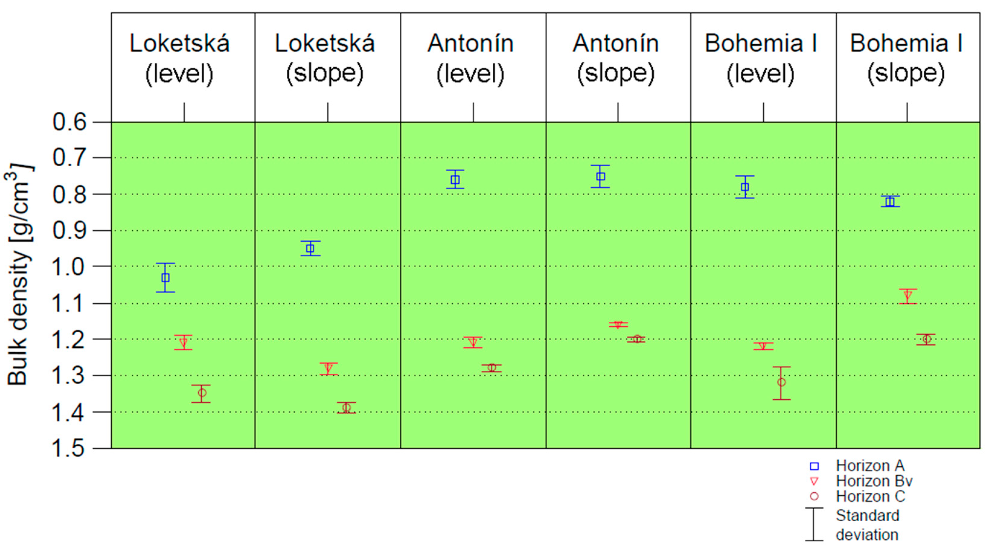
| Mineral horizon thickness [cm] | A | 2 | 4 | 5 | 5 | 19.5 | 11 |
| Bv | 10 | 15 | 31 | 30 | 50.5 | 44 | |
| C | >12 | >19 | >36 | >35 | >70 | >55 | |
| Horizon description | Humus type | Moder to mull | Moder to mull | Mull | Mull | Moder to mull | Moder to mull |
| L | Last year’s dead grasses, in places individual fallen alder leaves | Last year’s dead grasses, in places individual fallen alder leaves | Continuous layer of last season’s litter | Layer of irregularly deposited last season’s litter (up to 1 cm), horizon A visible on the surface | 1 cm of last year’s litter with significant decomposition (due to maple leaves) | Approximately 60% of the area without overlying organic horizons, horizon A visible on the surface. Mixed L and F horizons. Indistinctive H horizon. | |
| F | Residues of decomposed alder leaves | Residues of decomposed alder leaves | Imperceptible | Barely present (mixed with upper A horizon) | Up to 1 cm, dark brown, transfers directly to A horizon | ||
| H | Not present - soil surface generally covered with grassland under trees, locally disturbed by animals (wild pigs) | Not present - soil surface generally covered with grassland under trees. Approximately 50 % of the surface is not covered by vegetation or litter | Transfers to A horizon | Imperceptible | Indistinctive, surface of A horizon covered with a large number of hawthorn seeds | ||
| A | Brown-black, crumbly and loose in the upper part, slightly moist, finely polyhedral in the lower part, compact, moist, clay loamy, weakly plastic. Densely rooted with roots up to 5 mm diameter. Grass roots, and roots of trees up to 1 cm diameter in some places. The horizon contains a skeleton of up to 20% composed of decomposed cypress clay up to 2 cm in size. The transition is sharp and slightly undulating. Edaphon was not observed. | Brown-black, crumbly and loose in the upper part, slightly moist and polyhedral in the lower part, compact, moist, clay loamy, weakly plastic. Densely rooted with roots up to 5 mm diameter. Grass roots, and roots of trees up to 1 cm diameter in some places. The horizon contains a skeleton of up to 20% composed of decomposed cypress clay up to 2 cm in size. The transition is distinct (2–5 cm) and slightly undulating. Edaphon was not observed. | Brown-black, crumbly in the upper part, loose, compacted in the lower part, moist, clay-loamy, weakly plastic, densely rooted with roots up to 1 cm in diameter. Earthworms are seldom present in the horizon. No skeletal particles. It transitions clearly to the next horizon (2 cm). The transition is straight to slightly wavy. | Dark brown, loose, crumbly in the upper part, compacted in deeper layers, densely rooted, with an admixture of earthworm excrement, and earthworms. No skeletal particles. The transition to the next horizon is distinctly straight to slightly wavy. | Brown-black, crumbly to finely polyhedral, moist, loamy, weakly plastic, loose on the surface. The horizon is densely rooted, even with strong roots, with high biological activity (active earthworms were found). No skeletal particles. The transition to the Bv horizon is straight, distinctive, with vertical intrusions of organic matter to the upper part of Bv horizon. | Brown-black, crumbly on the surface, finely polyhedral to polyhedral within the horizon, clay loamy, moist, weakly plastic, loose on the surface, firmer deeper. The horizon is densely rooted with fine roots. Roots up to 5 cm in diameter are also common. Earthworms are seldom present. Without the presence of skeleton. It transitions clearly to the next horizon (up to 2 cm). The transition is straight to slightly wavy. | |
| Bv | The horizon is only faintly indicated at a depth of 2 to 12 cm, grey-brown, moist, clay loam, weakly plastic to plastic, coarse polyhedral structure indicated. Fine grass root content decreases rapidly with depth, sparse tree roots to 1 cm diameter. Skeleton is composed of residual weathering of cypress clays up to 25% in the whole volume of the horizon. The transition to the C horizon is distinct (2–5 cm), wavy. | Brownish rusty, moist, weakly plastic, without distinct structure. The skeleton is composed of weathered cypress wet clays with a volume of up to 25 %. The horizon is densely rooted with tree roots up to 5 mm in diameter, in some places up to 1 cm. The transition to horizon C is distinct (2–5 cm), slightly wavy. Edaphon was not observed. | Grey-red-brown, with a indications of roughly polyhedral structure, moist, weakly plastic to plastic. Coatings of secondary Fe and Mn minerals are developed on deeply weathered cypress clays with a still visible layered structure. Sparse rooting, seldom with roots up to 1.5 cm. The horizon is without the presence of an edaphon, the skeleton consists of weathered cypress clays weathered throughout their entire volume, the layered structure is still clear. No resistance when breaking apart. The transition to the next horizon is clear (up to 2 cm). The transition is wavy. | The upper part is reddish-yellow-brown, the color changes to yellow-brown towards the depth. Moist, the skeleton is porous, with coatings of secondary Fe and Mn minerals. The matrix is plastic, with indications of the development of a roughly polyhedral structure in the upper parts. The entire horizon is sparsely covered with roots up to 5 mm thick. There is an admixture of porcelanite. Less noticeable coal particles. The transition to the next horizon is clear. | Red-brown color gradually changes from brown-ochre to brown-yellow color. Without distinct structure, loamy clayey, moist, weakly plastic to plastic, stiff, containing weathered cypress clays (pieces of clay are soft, ocher-rusty in the entire volume) with coatings of secondary minerals (Fe, Mn) on the surface. Remains of coal at a depth of approx. 50 cm. Skeleton content approx. 50%, transition to the next horizon diffuse. Horizon is rooted to 65 cm. | Strong reddish-brown, moist, weakly plastic to plastic, without distinct structure, rooted with roots up to 1 cm in diameter, with a high content of coal residues, compacted. Without the presence of edaphon, no skeletal particles, the cypress clays are completely weathered, the layered structure is still clear, no resistance when breaking apart. The transition to the next horizon is clear, (up to 2 cm). The transition is wavy. | |
| C | The red-brown-grey matrix consists of moist, heavily weathered cypress clays of coarse consistency. The skeletal content is approximately 80 %. The skeleton is moist, soft and easy to break with a spade. The spaces between the skeleton are filled with a yellowish-brown clay loam, a plastic mass of clayey consistency. Tree roots up to 5 mm in diameter occur sporadically to a depth of 80 cm. | Brownish rusty, with a skeletal content of up to 80 %, the skeleton is composed of distinct pieces of wet soft cypress clay which are easily dislodged with a spade. The cypress clay pieces are oxidized throughout their volume to a soil horizon depth of approximately 40 cm. They are rusty-brown in color when cut. After 40 cm, the larger pieces of cypress clay are rusty brown only on the surface, inside they are grey, unoxidized. From about 70 cm downwards, there is moist, slightly weathered spoil material. Tree roots occur sporadically to a depth of 70 cm. Edaphon was not observed. | Gray-yellow-brown, formed by cypress clays on the surface with coatings of secondary Fe and Mn minerals, partially weathered (inside, their original gray color is preserved). Moist, plastic to strongly plastic. Rooting is sparse with fine roots that are visible up to a depth of 80 cm. Below 80 cm, yellow-red-brown color with surface coatings of secondary minerals, and less weathered cypress claystones. Below 100 cm, the horizon is wet and sticky, with no presence of roots. In the entire profile, coal residues can be found. | Brown-yellow-gray in color, without a distinct structure, moist, highly plastic. The skeletal particles consist of cypress clays, gray inside and yellow-gray on the surface. Intrusions of rusty sands in some places of the horizon can be found. | Brown-yellow color. In the horizon, strongly weathered cypress clays are present (brown-rusty on the surface, blue-gray inside the skeletal pieces). On the surface, coatings of secondary minerals with a high content of Fe and Mn. Coal residues are seldom mixed in the horizon. Skeletal content app. 80%. Roots are rarely present to a depth of 90 cm. | Yellow-brown. Cypress clays are no longer completely weathered, they are rusty yellow on the surface, soft, blue-gray on the inside, hard. A large amount of coal remains present in the horizon, often in layers. There is no clear structure in the profile, the soil is moist, weakly plastic to plastic. Rooting with small roots to a depth of 110 cm. After 110 cm, clays are less weathered, soil is more compacted, and greater presence of coal can be observed. | |
| Analysis | Horizon | Loketská Level | SD | Loketská Slope | SD | Antonín Level | SD | Antonín Slope | SD | Bohemia I Level | SD | Bohemia I Slope | SD |
|---|---|---|---|---|---|---|---|---|---|---|---|---|---|
| pH [H2O] | A | 6.57 | 0.02 | 7.67 | 0.03 | 7.13 | 0.02 | 6.95 | 0.00 | 6.12 | 0.04 | 6.84 | 0.04 |
| Bv | 7.25 | 0.00 | 7.93 | 0.03 | 8.13 | 0.03 | 7.94 | 0.01 | 6.60 | 0.04 | 7.64 | 0.03 | |
| C | 7.61 | 0.06 | 8.22 | 0.07 | 8.47 | 0.05 | 7.96 | 0.03 | 7.48 | 0.02 | 7.96 | 0.06 | |
| >1 m | 7.72 | 0.01 | 8.30 | 0.02 | 8.26 | 0.07 | 7.81 | 0.04 | 8.10 | 0.02 | 8.20 | 0.00 | |
| pH [KCl] | A | 6.12 | 0.02 | 6.88 | 0.02 | 6.52 | 0.00 | 6.51 | 0.00 | 5.80 | 0.04 | 6.53 | 0.02 |
| Bv | 6.81 | 0.02 | 7.59 | 0.01 | 7.70 | 0.03 | 7.58 | 0.01 | 6.12 | 0.00 | 7.15 | 0.02 | |
| C | 7.19 | 0.02 | 7.94 | 0.03 | 7.98 | 0.04 | 7.85 | 0.02 | 7.16 | 0.06 | 7.79 | 0.07 | |
| >1 m | 7.63 | 0.01 | 8.03 | 0.03 | 7.87 | 0.02 | 7.36 | 0.02 | 7.87 | 0.02 | 8.05 | 0.03 | |
| CEC [cmol(+)/kg] | A | 26.58 | 0.22 | 22.82 | 0.01 | 36.32 | 1.97 | 33.61 | 0.13 | 29.69 | 0.32 | 35.29 | 0.03 |
| Bv | 19.99 | 1.22 | 10.92 | 0.11 | 18.79 | 0.34 | 18.15 | 0.28 | 15.05 | 0.15 | 24.10 | 0.33 | |
| C | 14.62 | 0.02 | 9.05 | 0.06 | 15.80 | 0.29 | 17.36 | 0.21 | 15.01 | 0.28 | 17.69 | 0.28 | |
| >1 m | 15.90 | 1.26 | 10.47 | 0.63 | 21.29 | 3.46 | 26.32 | 0.61 | 18.29 | 2.39 | 17.01 | 0.50 | |
| Cox [%] | A | 8.49 | 0.32 | 7.11 | 0.08 | 9.87 | 0.10 | 8.72 | 0.04 | 10.47 | 0.18 | 9.81 | 0.02 |
| Bv | 2.06 | 0.00 | 2.81 | 0.13 | 2.43 | 0.20 | 3.11 | 0.15 | 3.96 | 0.04 | 5.97 | 0.07 | |
| C | 1.25 | 0.07 | 2.19 | 0.04 | 2.50 | 0.12 | 2.78 | 0.09 | 3.50 | 0.03 | 4.15 | 0.59 | |
| >1 m | 4.16 | 0.20 | 2.11 | 0.03 | 2.90 | 0.07 | 6.00 | 0.18 | 2.96 | 0.06 | 4.01 | 0.10 | |
| A400/A600 | A | 5.38 | 0.25 | 5.34 | 0.26 | 5.99 | 0.06 | 6.03 | 0.34 | 4.17 | 0.11 | 3.83 | 0.15 |
| Pavailable [mg/kg] | A | 15.00 | 1.03 | 6.66 | 0.08 | 14.13 | 0.09 | 16.45 | 0.45 | 14.50 | 0.63 | 14.69 | 0.52 |
| Bv | 6.31 | 0.05 | ND | / | ND | / | ND | / | 1.51 | 0.84 | ND | / | |
| C | 4.70 | 1.11 | ND | / | ND | / | ND | / | ND | / | ND | / | |
| >1 m | ND | / | ND | / | ND | / | ND | / | ND | / | ND | / | |
| Kavailable [mg/kg] | A | 442 | 14.45 | 435 | 3.34 | 490 | 7.82 | 416 | 7.34 | 481 | 2.63 | 754 | 9.88 |
| Bv | 284 | 12.09 | 243 | 8.83 | 286 | 5.74 | 308 | 12.33 | 404 | 102.2 | 459 | 2.12 | |
| C | 227 | 11.60 | 226 | 2.43 | 256 | 3.10 | 334 | 18.91 | 209 | 1.76 | 327 | 1.83 | |
| >1 m | 310 | 5.89 | 236 | 4.74 | 301 | 39.86 | 270 | 1.74 | 285 | 2.16 | 318 | 3.49 | |
| Caavailable [mg/kg] | A | 2651 | 119.9 | 5386 | 72.9 | 4292 | 77.6 | 3209 | 116.3 | 3661 | 52.9 | 4221 | 47.6 |
| Bv | 1960 | 27.3 | 8498 | 397.6 | 7389 | 263.9 | 5612 | 172.5 | 2937 | 903.1 | 4883 | 81.0 | |
| C | 1781 | 101.3 | 8386 | 401.7 | 5172 | 16.7 | 5499 | 383.2 | 2481 | 112.3 | 5797 | 119.1 | |
| >1 m | 6678 | 26.2 | 17,587 | 1277 | 2650 | 337.0 | 1449 | 1.0 | 2716 | 3.2 | 2935 | 17.4 | |
| Mgavailable [mg/kg] | A | 1043 | 54.8 | 1059 | 8.2 | 1884 | 8.4 | 1317 | 53.9 | 1064 | 10.2 | 1460 | 17.3 |
| Bv | 981 | 1.8 | 813 | 0.9 | 1393 | 22.0 | 990 | 35.4 | 1175 | 349.0 | 996 | 8.2 | |
| C | 858 | 46.4 | 1082 | 18.2 | 1389 | 48.5 | 1515 | 126.3 | 1420 | 10.5 | 1599 | 3.9 | |
| >1 m | 1170 | 7.7 | 1369 | 23.7 | 1461 | 163.3 | 1885 | 57.5 | 1892 | 17.5 | 2145 | 14.9 | |
| Alavailable [mg/kg] | A | 392.60 | 7.96 | 301.70 | 8.46 | 366.81 | 19.49 | 285.79 | 0.49 | 580.80 | 9.36 | 445.00 | 16.86 |
| Bv | 334.92 | 2.65 | 50.78 | 6.46 | 102.76 | 13.38 | 73.16 | 2.69 | 394.60 | 120.99 | 278.96 | 8.62 | |
| C | 324.27 | 12.74 | 30.00 | 2.90 | 62.98 | 0.80 | 93.77 | 2.44 | 236.79 | 6.50 | 210.98 | 4.70 | |
| >1 m | 72.05 | 32.49 | 31.93 | 21.04 | 223.99 | 43.30 | 250.72 | 50.10 | 215.48 | 23.05 | 193.43 | 16.31 | |
| Feavailable [mg/kg] | A | 258 | 10.93 | 346 | 3.49 | 519 | 16.81 | 432 | 1.07 | 410 | 3.64 | 443 | 8.80 |
| Bv | 122 | 0.97 | 228 | 13.34 | 314 | 27.20 | 234 | 6.92 | 420 | 134.3 | 336 | 5.85 | |
| C | 142 | 7.83 | 193 | 14.35 | 225 | 3.95 | 242 | 2.67 | 336 | 4.90 | 270 | 6.79 | |
| >1 m | 268 | 11.98 | 251 | 2.69 | 310 | 4.90 | 324 | 18.04 | 322 | 11.43 | 310 | 7.10 | |
| Mnavailable [mg/kg] | A | 57.82 | 4.02 | 118.03 | 0.95 | 108.43 | 4.62 | 87.31 | 1.50 | 81.04 | 1.03 | 86.55 | 0.45 |
| Bv | 60.23 | 0.36 | 153.18 | 5.41 | 126.94 | 3.24 | 105.63 | 2.55 | 209.74 | 62.53 | 118.60 | 6.51 | |
| C | 51.90 | 5.46 | 128.21 | 5.95 | 78.80 | 1.97 | 82.43 | 6.22 | 103.58 | 2.61 | 132.65 | 3.15 | |
| >1 m | 97.92 | 1.29 | 174.97 | 0.35 | 47.29 | 4.06 | 55.00 | 2.47 | 83.20 | 1.94 | 68.98 | 0.26 |
| Element [mg/kg] | Horizon | 1 | 2 | 3 | 4 | 5 |
|---|---|---|---|---|---|---|
| Insufficient | Low | Sufficient | High | Very High | ||
| P | Organo-mineral | ≤8 | 9–17 | 18–30 | 31–50 | >50 |
| Mineral | ≤7 | 8–19 | 20–40 | 41–70 | >70 | |
| K | Organo-mineral | ≤70 | 71–110 | 111–150 | 151–190 | >190 |
| Mineral | ≤40 | 41–60 | 61–90 | 91–120 | >120 | |
| Ca | Organo-mineral | ≤310 | 311–630 | 631–1200 | 1201–1870 | >1870 |
| Mineral | ≤190 | 191–500 | 501–950 | 951–1530 | >1530 | |
| Mg | Organo-mineral | ≤45 | 46–90 | 91–160 | 161–250 | >250 |
| Mineral | ≤25 | 26–50 | 51–90 | 91–150 | >150 |
| Element [mg/kg] | Horizon | 1 | 2 | 3 | 4 | 5 |
|---|---|---|---|---|---|---|
| Very Low | Low | Medium | High | Very High | ||
| Al | Organo-mineral | ≤1830 | 1831–3000 | 3001–4200 | 4201–5800 | >5800 |
| Mineral | ≤2100 | 2101–3600 | 3601–5500 | 5501–8000 | >8000 | |
| Fe | Organo-mineral | ≤2400 | 2401–4300 | 4301–6400 | 6401–9100 | >9100 |
| Mineral | ≤2800 | 2801–5100 | 5101–7900 | 7901–11,700 | >11,700 | |
| Mn | Organo-mineral | ≤200 | 201–600 | 601–1000 | 1001–1400 | >1400 |
| Mineral | ≤120 | 121–310 | 311–500 | 501–690 | >690 |
Disclaimer/Publisher’s Note: The statements, opinions and data contained in all publications are solely those of the individual author(s) and contributor(s) and not of MDPI and/or the editor(s). MDPI and/or the editor(s) disclaim responsibility for any injury to people or property resulting from any ideas, methods, instructions or products referred to in the content. |
© 2024 by the authors. Licensee MDPI, Basel, Switzerland. This article is an open access article distributed under the terms and conditions of the Creative Commons Attribution (CC BY) license (https://creativecommons.org/licenses/by/4.0/).
Share and Cite
Spasić, M.; Vacek, O.; Vejvodová, K.; Borůvka, L.; Tejnecký, V.; Drábek, O. Profile Development and Soil Properties of Three Forest Reclamations of Different Ages in Sokolov Mining Basin, Czech Republic. Forests 2024, 15, 650. https://doi.org/10.3390/f15040650
Spasić M, Vacek O, Vejvodová K, Borůvka L, Tejnecký V, Drábek O. Profile Development and Soil Properties of Three Forest Reclamations of Different Ages in Sokolov Mining Basin, Czech Republic. Forests. 2024; 15(4):650. https://doi.org/10.3390/f15040650
Chicago/Turabian StyleSpasić, Marko, Oldřich Vacek, Kateřina Vejvodová, Luboš Borůvka, Václav Tejnecký, and Ondřej Drábek. 2024. "Profile Development and Soil Properties of Three Forest Reclamations of Different Ages in Sokolov Mining Basin, Czech Republic" Forests 15, no. 4: 650. https://doi.org/10.3390/f15040650