
Can Ensemble Techniques and Large-Scale Fire Datasets Improve Predictions of Forest Fire Probability Due to Climate Change?—A Case Study from the Republic of Korea


Abstract
:1. Introduction
2. Data and Methods
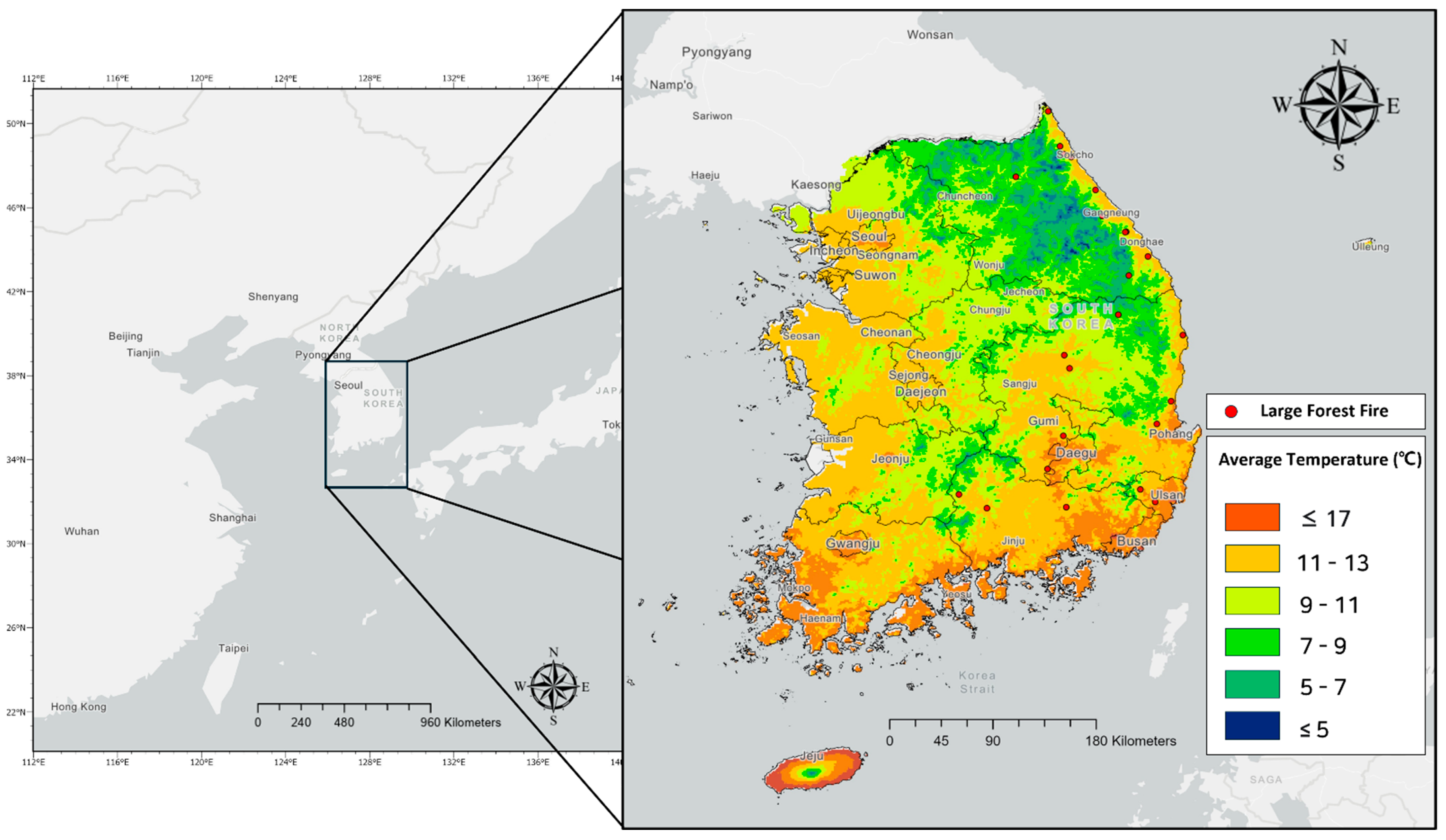
2.1. Study Area
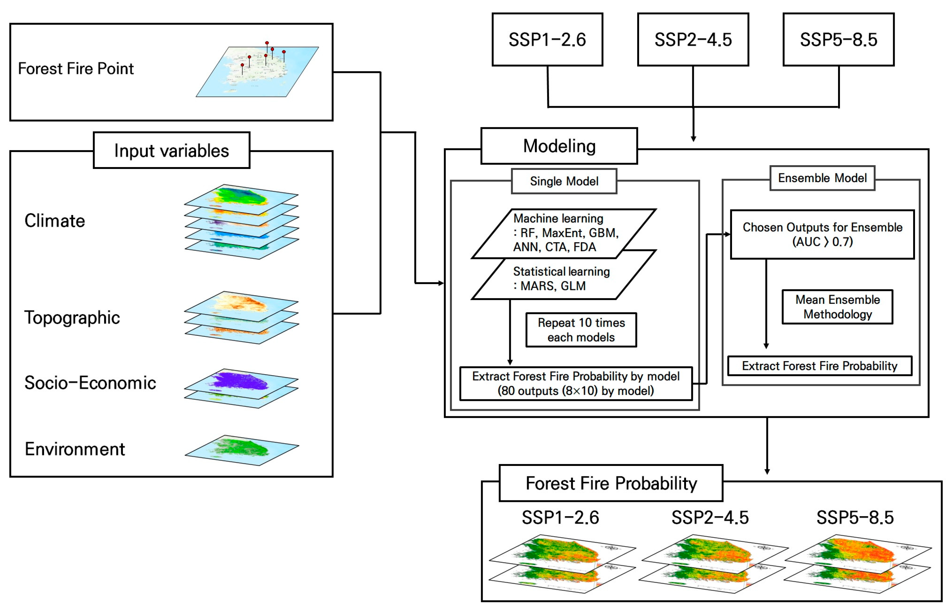
2.2. Data
2.3. Machine Learning and Ensemble Method
3. Results and Discussion
3.1. Model Accuracy and Variable Importance
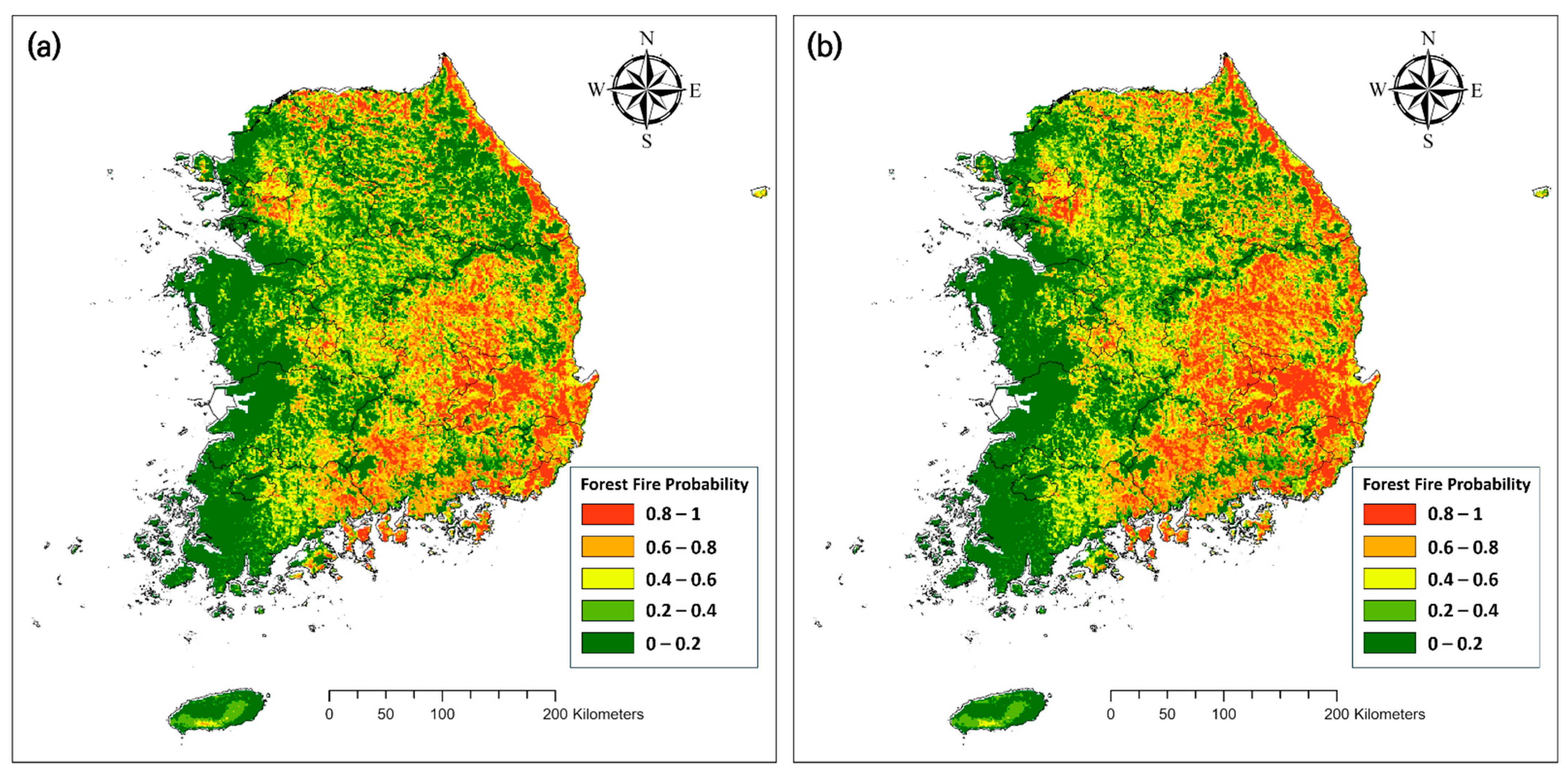
3.2. Forest Fire Probability Attributable to SSP Scenario
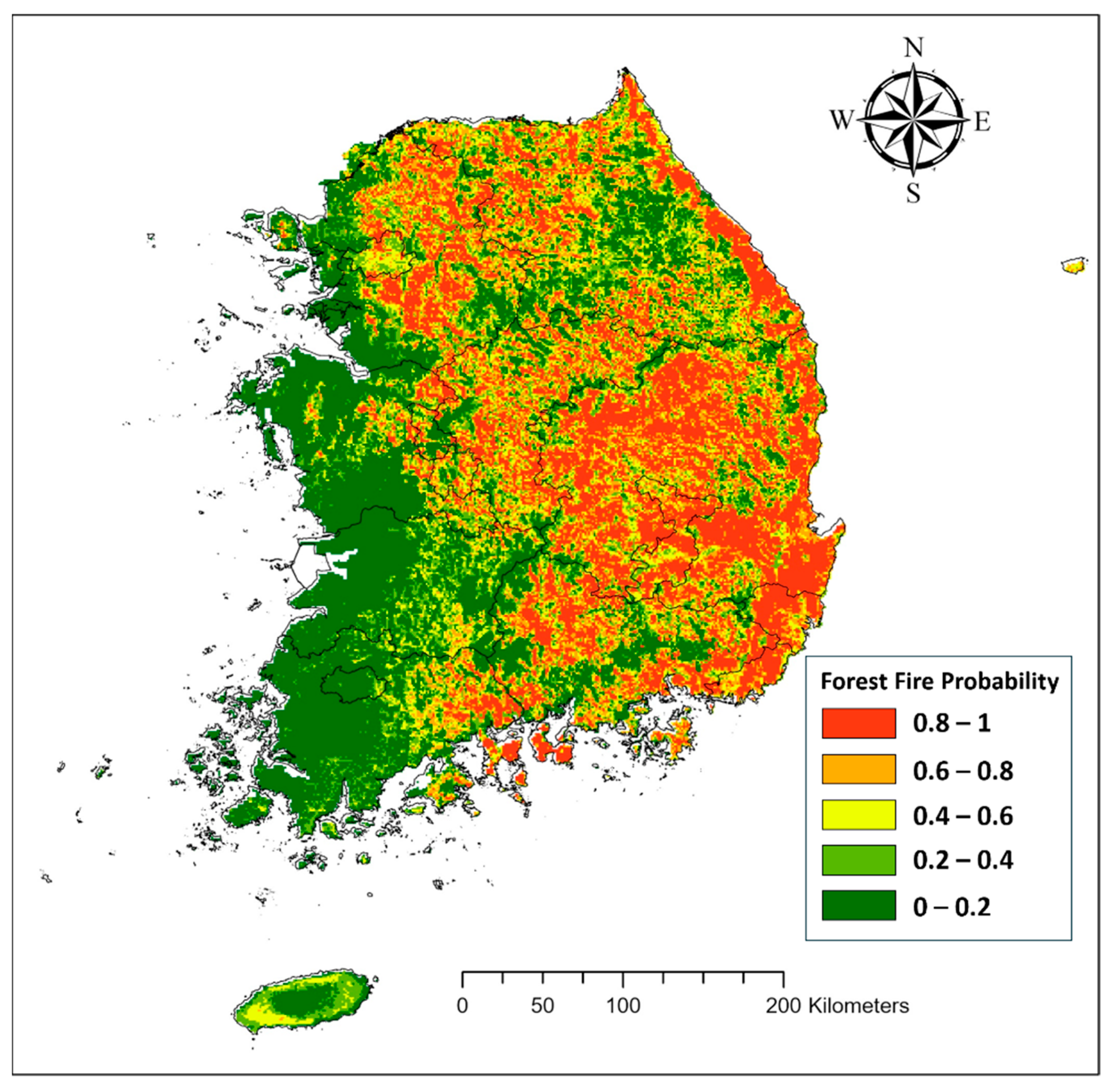
3.2.1. Baseline Period
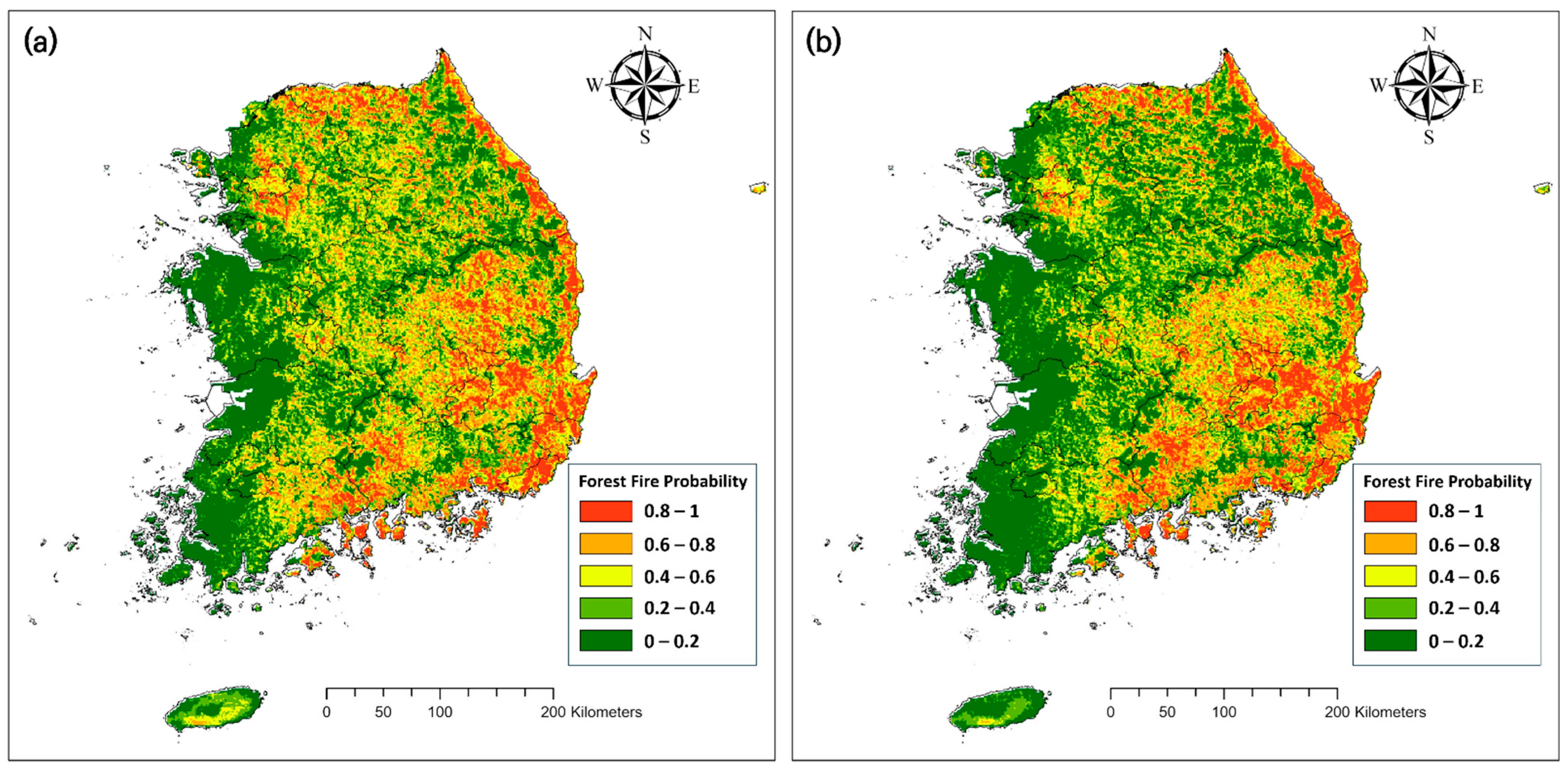
3.2.2. SSP1-2.6
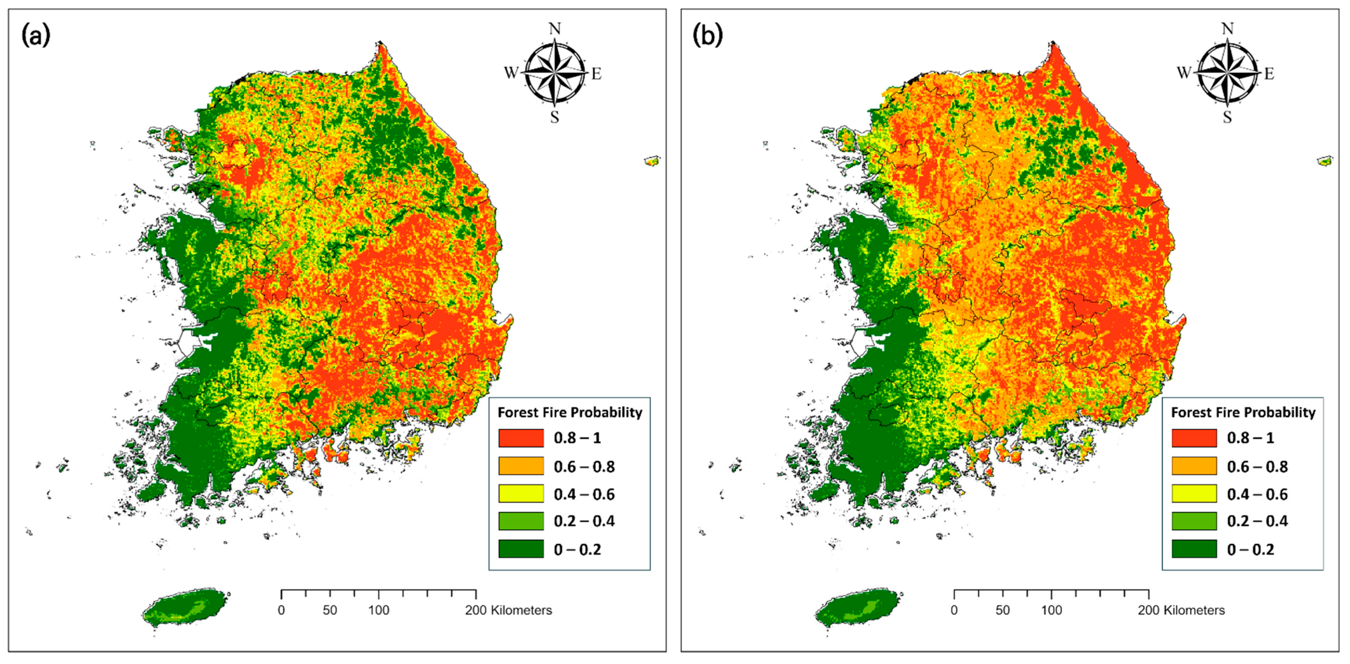
3.2.3. SSP2-4.5
3.2.4. SSP5-8.5
3.2.5. Changes in Forest Fire Risk
3.3. Implications and Limitations
4. Conclusions
Author Contributions
Funding
Data Availability Statement
Conflicts of Interest
References
- Nanditha, J.S.; Kushwaha, A.P.; Singh, R.; Malik, I.; Solanki, H.; Chuphal, D.S.; Dangar, S.; Mahto, S.S.; Vegad, U.; Mishra, V. The Pakistan flood of august 2022: Causes and implications. Earth’s Future 2023, 11, e2022EF003230. [Google Scholar] [CrossRef]
- Nolan, R.H.; Boer, M.M.; Collins, L.; de Dios, V.R.; Clarke, H.; Jenkins, M.; Kenny, B.; Bradstock, R.A. Causes and consequences of eastern Australia’s 2019–20 season of mega-fires. Glob. Chang. Biol. 2020, 26, 1039–1041. [Google Scholar] [CrossRef]
- Ehsani, M.R.; Arevalo, J.; Risanto, C.B.; Javadian, M.; Devine, C.J.; Arabzadeh, A.; Venegas-Quiñones, H.L.; Dell’Oro, A.P.; Behrangi, A. 2019–2020 Australia Fire and Its Relationship to Hydroclimatological and Vegetation Variabilities. Water 2020, 12, 3067. [Google Scholar] [CrossRef]
- Yeom, C.-H.; Lee, S.Y.; Park, H.S.; Kwon, C.G. A Study on Facilities Damage Characteristics Cused by Forest Fire in Goseong-Gun. J. Korean Soc. Disaster Inf. 2019, 15, 469–478. [Google Scholar]
- Pechony, O.; Shindell, D.T. Driving forces of global wildfires over the past millennium and the forthcoming century. Proc. Natl. Acad. Sci. USA 2010, 107, 19167–19170. [Google Scholar] [CrossRef]
- Sutanto, S.J.; Vitolo, C.; Di Napoli, C.; D’Andrea, M.; Van Lanen, H.A. Heatwaves, droughts, and fires: Exploring compound and cascading dry hazards at the pan-European scale. Environ. Int. 2020, 134, 105276. [Google Scholar] [CrossRef]
- Sung, M.K.; Lim, G.H.; Choi, E.H.; Lee, Y.Y.; Won, M.S.; Koo, K.S. Climate change over Korea and its relation to the forest fire occurrence. Atmosphere 2010, 20, 27–35. [Google Scholar]
- Chung, Y.S.; Yoon, M.B.; Kim, H.S. On Climate Variations and Changes Observed in South Korea. Clim. Change 2004, 66, 151–161. [Google Scholar] [CrossRef]
- Durán, R.; Varela, E.; Garza, D.; Prada, A.; Vázquez, M.; Soliño, M. Valuation of terrestrial and marine biodiversity losses caused by forest wildfires. J. Behav. Exp. Econ. 2017, 71, 88–95. [Google Scholar] [CrossRef]
- Kalogiannidis, S.; Chatzitheodoridis, F.; Kalfas, D.; Patitsa, C.; Papagrigoriou, A. Socio-Psychological, Economic and Environmental Effects of Forest Fires. Fire 2023, 6, 280. [Google Scholar] [CrossRef]
- Wotton, B.M.; Nock, C.A.; Flannigan, M.D. Forest fire occurrence and climate change in Canada. Int. J. Wildland Fire 2010, 19, 253–271. [Google Scholar] [CrossRef]
- Ahn, Y.S.; Ryu, S.R.; Lim, J.H.; Lee, C.H.; Shin, J.H.; Choi, W.I.; Lee, B.D.; Jeong, J.-H.; An, K.W.; Seo, J.I. Effects of forest fires on forest ecosystems in eastern coastal areas of Korea and an overview of restoration projects. Landsc. Ecol. Eng. 2014, 10, 229–237. [Google Scholar] [CrossRef]
- The 6th Forest Master Plans; Korea Forest Service: Daejeon, Republic of Korea, 2021.
- Sakr, G.E.; Elhajj, I.H.; Mitri, G.; Wejinya, U.C. Artificial intelligence for forest fire prediction. In Proceedings of the IEEE/ASME International Conference on Advanced Intelligent Mechatronics, Montreal, QC, Canada, 6–9 July 2010; pp. 1311–1316. [Google Scholar] [CrossRef]
- Chae, K.-J.; Lee, Y.R.; Cho, Y.J.; Park, J.H. Development of Gangwon Province Forest Fire Prediction Model using Machine Learning and Sampling. Korea J. BigData 2018, 3, 71–78. [Google Scholar] [CrossRef]
- Jordan, M.I.; Mitchell, T.M. Machine learning: Trends, perspectives, and prospects. Science 2015, 349, 255–260. [Google Scholar] [CrossRef]
- Linardos, V.; Drakaki, M.; Tzionas, P.; Karnavas, Y.L. Machine Learning in Disaster Management: Recent Developments in Methods and Applications. Mach. Learn. Knowl. Extr. 2022, 4, 446–473. [Google Scholar] [CrossRef]
- Shmuel, A.; Heifetz, E. Global Wildfire Susceptibility Mapping Based on Machine Learning Models. Forests 2022, 13, 1050. [Google Scholar] [CrossRef]
- Jo, H.-W.; Krasovskiy, A.; Hong, M.; Corning, S.; Kim, W.; Kraxner, F.; Lee, W.-K. Modeling Historical and Future Forest Fires in South Korea: The FLAM Optimization Approach. Remote Sens. 2023, 15, 1446. [Google Scholar] [CrossRef]
- Ghorbanzadeh, O.; Blaschke, T.; Gholamnia, K.; Aryal, J. Forest Fire Susceptibility and Risk Mapping Using Social/Infrastructural Vulnerability and Environmental Variables. Fire 2019, 2, 50. [Google Scholar] [CrossRef]
- Cadastral Statistical Annual Report; Ministry of Land, Infrastructure and Transport: Sejong-si, Republic of Korea, 2022.
- Statistical Yearbook of Forestry; Korea Forest Service: Daejeon, Republic of Korea, 2021.
- 2019 Gangwon East Coast Forest Fire White Paper; Ministry of Public Administration and Security: Sejong-si, Republic of Korea, 2019.
- Annual Climatological Report; Korea Meteorological Administration: Seoul, Republic of Korea, 2022.
- Hirose, K.; Kim, C.K.; Kim, C.S.; Chang, B.W.; Igarashi, Y.; Aoyama, M. Wet and dry deposition patterns of plutonium in Daejeon, Korea. Sci. Total Environ. 2009, 332, 243–252. [Google Scholar] [CrossRef]
- Korea Meteorological Administration. Available online: http://climate.go.kr/home/ (accessed on 23 September 2023).
- Daly, C.; Neilson, R.P.; Phillips, D.L. A Statistical-Topographic Model for Mapping Climatological Precipitation over Mountainous Terrain. J. Appl. Meteorol. Climatol. 1994, 33, 140–158. [Google Scholar] [CrossRef]
- Daly, C.; Gibson, W.; Taylor, G.; Johnson, G.; Pasteris, P. A knowledge-based approach to the statistical mapping of climate. Clim. Res 2002, 22, 99–113. [Google Scholar] [CrossRef]
- Daly, C.; Helmer, E.H.; Quiñones, M. Mapping the climate of Puerto Rico, Vieques and Culebra. Int. J. Clim 2003, 23, 1359–1381. [Google Scholar] [CrossRef]
- Kim, J.U.; Sang, J.; Kim, M.K.; Byun, Y.H.; Kim, D.H.; Kim, T.J. Future Climate Projection in South Korea using the High-Resolution SSP Scenarios based on Statistical Downscaling. J. Clim. Res. 2022, 17, 89–106. [Google Scholar] [CrossRef]
- Lee, B.-D.; Koo, K.-S.; Lee, M.-B. Forest Fire Direction and Spread Characteristics by Field Investigations. Fire Sci. Eng. 2009, 23, 96–102. [Google Scholar]
- Kim, S.J.; Lim, C.-H.; Kim, G.S.; Lee, J.; Geiger, T.; Rahmati, O.; Son, Y.; Lee, W.-K. Multi-Temporal Analysis of Forest Fire Probability Using Socio-Economic and Environmental Variables. Remote Sens. 2019, 11, 86. [Google Scholar] [CrossRef]
- Danielsson, P.E. Euclidean distance mapping. Comput. Graph. Image Process. 1980, 14, 227–248. [Google Scholar] [CrossRef]
- Pearson, K. On the criterion that a given system of deviations from the probable in the case of a correlated system of variables is such that it can be reasonably supposed to have arisen from random sampling. Lond. Edinb. Dublin Philos. Mag. J. Sci. 1900, 50, 157–175. [Google Scholar] [CrossRef]
- Iban, M.C.; Sekertekin, A. Machine learning based wildfire susceptibility mapping using remotely sensed fire data and GIS: A case study of Adana and Mersin provinces, Turkey. Ecol. Inform. 2022, 69, 101647. [Google Scholar] [CrossRef]
- Swets, J.A. Measuring the accuracy of diagnostic systems. Science 1988, 240, 1285–1293. [Google Scholar] [CrossRef]
- Bradley, A.P. The use of the area under the ROC curve in the evaluation of machine learning algorithms. Pattern Recognit. 1997, 30, 1145–1159. [Google Scholar] [CrossRef]
- He, Q.; Jiang, Z.; Wang, M.; Liu, K. Landslide and Wildfire Susceptibility Assessment in Southeast Asia Using Ensemble Machine Learning Methods. Remote Sens. 2021, 13, 1572. [Google Scholar] [CrossRef]
- Noce, S.; Collalti, A.; Santini, M. Likelihood of changes in forest species suitability, distribution, and diversity under future climate: The case of Southern Europe. Ecol. Evol. 2017, 7, 9358–9375. [Google Scholar] [CrossRef]
- Khan, S.; Verma, S. Ensemble modeling to predict the impact of future climate change on the global distribution of Olea europaea subsp. cuspidate. Front. For. Glob. Chang. 2022, 5, 977691. [Google Scholar] [CrossRef]
- Kim, J.S.; Park, S.Y. Landslide Susceptibility Mapping Using Ensemble FR and LR models at the Inje Area, Korea. J. Korean Soc. Geospat. Inf. Sci. 2017, 25, 19–27. [Google Scholar]
- Ahn, H.G.; Lim, C.H. Assessing habitat suitability for timber species in South Korea under SSP scenarios. Korean J. Environ. Biol. 2022, 40, 567–578. [Google Scholar] [CrossRef]
- Thuiller, W.; Lafourcade, B.; Engler, R.; Araújo, M.B. BIOMOD–A platform for ensemble forecasting of species distributions. Ecography 2009, 32, 369–373. [Google Scholar] [CrossRef]
- Park, C.H. Deduction of Risk Assessment (RA) Items through the Characteristics and Vulnerabilities of Gangwon Fire. J. Soc. Cult. Herit. Disaster Prev. 2019, 4, 55–64. [Google Scholar]
- Lee, C.J.; Lim, M.Y.; Lee, Y.H. Machine Learning for Big Data Analytics in Development of Wildfire Prediction Models. J. Korean Soc. Hazard Mitig. 2023, 23, 29–39. [Google Scholar] [CrossRef]
- Rodrigues, M.; de la Riva, J. An insight into machine-learning algorithms to model human-caused wildfire occurrence. Environ. Model. Softw. 2014, 57, 192–201. [Google Scholar] [CrossRef]
- Kalantar, B.; Ueda, N.; Idrees, M.O.; Janizadeh, S.; Ahmadi, K.; Shabani, F. Forest Fire Susceptibility Prediction Based on Machine Learning Models with Resampling Algorithms on Remote Sensing Data. Remote Sens. 2020, 12, 3682. [Google Scholar] [CrossRef]
- Pang, Y.; Li, Y.; Feng, Z.; Feng, Z.; Zhao, Z.; Chen, S.; Zhang, H. Forest Fire Occurrence Prediction in China Based on Machine Learning Methods. Remote Sens. 2022, 14, 5546. [Google Scholar] [CrossRef]


| Input Variable | Variable Name | Unit | Source |
|---|---|---|---|
| Climate | Max. temperature of the warmest month | °C | Korea Meteorological Administration |
| Min. temperature of the coldest month | °C | Korea Meteorological Administration | |
| Precipitation of the driest month | mm | Korea Meteorological Administration | |
| Max. windspeed | m/s | Korea Meteorological Administration | |
| Relative humidity during spring | % | Korea Meteorological Administration | |
| Topographic | Elevation | m | NASA |
| Topographic wetness index | - | - | |
| Aspect | - | - | |
| Socio-economic | Distance from urban area | m | Land cover map from the Korea Ministry of Environment |
| Population density | People per km2 | Population census from the Korean Statistical Information Service | |
| Environment | Forest type | - | Land cover map from the Korea Ministry of Environment |
| Model | AUC | |
|---|---|---|
| Machine learning | Random Forest | 0.732 |
| MaxEnt | 0.746 | |
| Generalized Boosting Model | 0.725 | |
| Artificial Neural Networks | 0.590 | |
| Classification Tree Analysis | 0.579 | |
| Flexible Discriminant Analysis | 0.677 | |
| Statistical learning | Multivariate Adaptive Regression Splines | 0.689 |
| Generalized Linear Model | 0.660 | |
| Ensemble | Mean | 0.976 |
| Variable Type | Variable | Mean Importance |
|---|---|---|
| Climate | Max. temperature of the warmest month | 0.066 |
| Min. temperature of the coldest month | 0.175 | |
| Precipitation of the driest month | 0.094 | |
| Max. windspeed | 0.021 | |
| Relative humidity during spring | 0.268 | |
| Topographic | Elevation | 0.352 |
| Topographic Wetness Index | 0.036 | |
| Aspect | 0.147 | |
| Socio-Economic | Distance from used area | 0.026 |
| Population density | 0.064 | |
| Environment | Forest type | 0.030 |
| Model | Current | 2040s | 2070s | ||||
|---|---|---|---|---|---|---|---|
| SSP1-2.6 | SSP2-4.5 | SSP5-8.5 | SSP1-2.6 | SSP2-4.5 | SSP5-8.5 | ||
| Forest fire risk area | 39,121 | 28,579 | 27,111 | 42,260 | 25,387 | 31,274 | 56,861 |
Disclaimer/Publisher’s Note: The statements, opinions and data contained in all publications are solely those of the individual author(s) and contributor(s) and not of MDPI and/or the editor(s). MDPI and/or the editor(s) disclaim responsibility for any injury to people or property resulting from any ideas, methods, instructions or products referred to in the content. |
© 2024 by the authors. Licensee MDPI, Basel, Switzerland. This article is an open access article distributed under the terms and conditions of the Creative Commons Attribution (CC BY) license (https://creativecommons.org/licenses/by/4.0/).
Share and Cite
Ahn, H.K.; Jung, H.; Lim, C.-H. Can Ensemble Techniques and Large-Scale Fire Datasets Improve Predictions of Forest Fire Probability Due to Climate Change?—A Case Study from the Republic of Korea. Forests 2024, 15, 503. https://doi.org/10.3390/f15030503
Ahn HK, Jung H, Lim C-H. Can Ensemble Techniques and Large-Scale Fire Datasets Improve Predictions of Forest Fire Probability Due to Climate Change?—A Case Study from the Republic of Korea. Forests. 2024; 15(3):503. https://doi.org/10.3390/f15030503
Chicago/Turabian StyleAhn, Hyeon Kwon, Huicheul Jung, and Chul-Hee Lim. 2024. "Can Ensemble Techniques and Large-Scale Fire Datasets Improve Predictions of Forest Fire Probability Due to Climate Change?—A Case Study from the Republic of Korea" Forests 15, no. 3: 503. https://doi.org/10.3390/f15030503