Article

Climate Change Adaptation Zones for Terrestrial Ecosystems—A Demonstration with Pinyon-Juniper Woodlands in the USA

NatureServe, Boulder, CO 80305, USA
*
Author to whom correspondence should be addressed.
Forests 2023, 14(8), 1533; https://doi.org/10.3390/f14081533
Submission received: 26 April 2023 / Revised: 30 June 2023 / Accepted: 22 July 2023 / Published: 27 July 2023
(This article belongs to the Special Issue The Extinction Crisis: How Bad, What Can Be Done?)

Abstract

:
Decision support tools are needed to ensure that appropriately timed and place-based adaptation is deployed in natural resource policy, planning, and management. Driven by accelerating climate change, analytical frameworks for adaptation are emerging to assist with these decisions. There is a natural relationship between climate change vulnerability assessments and adaptation responses, where low to high relative climate change vulnerability suggests “resistance” to “transformation” strategies for adaptation. The NatureServe Habitat Climate Change Vulnerability Index (HCCVI) embodies a process for ecosystem assessment that integrates both climate and non-climate data and knowledge to document the relative vulnerability of a given habitat or ecosystem type. The framework addresses climate exposure and ecosystem resilience. Since most measures of exposure and resilience are mapped, they can be utilized to create map zones that suggest climate-smart adaptation. We applied the HCCVI to a cross-section of 10 pinyon pine and juniper woodland ecosystem types in western North America. We then demonstrate the application of these outputs to adaptation zonation. Climate exposure defines relative adaptation strategies, while measures of resilience suggest specific priorities for habitat restoration and maintenance. By the mid-21st century, 3% and 23% of the combined area of these types in the United States was categorized as Directed Transformation or Autonomous Transformation, respectively. In just 10% of the combined areas for these types, Passive Resistance strategies are suggested.

1. Introduction

1.1. Climate Change Vulnerability

As the rate of climate change increases, substantial shifts in key ecological processes may cascade through natural communities, resulting in altered productivity, change in species composition, local extinctions, and ecological degradation or collapse [1,2,3,4]. Analytical frameworks for climate change vulnerability assessment have been developed to document the potential climate change effects on biodiversity [5]. Other frameworks have emerged to assist with identifying strategies for adapting to new conditions [6,7,8].
Climate change adaptation includes actions that enable ecosystems and people to better cope with or adjust to changing conditions. Emerging frameworks for adaptation responses in biodiversity conservation and natural resource management tend to categorize strategies along a continuum. At one end of the continuum are those strategies centered on “resistance” or generally defensive actions that maintain historical structures and functions. Others may be categorized as “resilience” strategies that aim to enhance capacity for change while still maintaining or restoring historical structures and functions but acknowledging inevitable change. At the opposite end of the continuum are strategies often categorized as “transformation”, where actions are directed toward new and anticipated structures and functions [9,10].
Where climate change vulnerability assessments indicate low vulnerability, management may concentrate on resistance-based strategies that aim to prevent or reduce further ecosystem degradation [11]. Where moderate vulnerability is indicated, strategies focused on restoring resilience will tend to be the priority [11]. Where vulnerability is indicated as high or very high over the upcoming decades, options for transformation strategies are likely to be required [12].
Importantly, the timeframe of the vulnerability assessments is critical to the adaptation response. For example, an estimated high vulnerability for the 2080s might suggest a transformation strategy that is entirely inappropriate to implement in the 2020s. Therefore, linkages between vulnerability assessment and adaptation strategy must be mindful of this temporal dimension [13].
It has become increasingly apparent that policymakers, land use planners, and natural resource managers need practical decision-support tools to formulate adaptive responses to climate change [6,7,8,9]. Ideally, decision support would come in the form of maps, text, and tabular outputs that provide insight into the character, severity, and timing of climate change effects and practical place-based and appropriately timed options for implementing adaptive management. We explore this need using outputs from one vulnerability assessment approach designed for natural communities.

1.2. NatureServe Habitat Climate Change Vulnerability Index

While most climate change vulnerability assessments focus on individual species, the NatureServe Habitat Climate Change Vulnerability Index (HCCVI) [14] integrates multiple ecologically relevant variables and results in a repeatable and transparent index of climate change vulnerability designed for natural communities. This framework can be applied to any ecosystem or habitat of interest to the user. It was designed to assist with determining those types that, in all or part of their distribution, are at varying levels of vulnerability to climate change impacts. It also indicates at least some of the primary factors contributing to climate change vulnerability; thus, some factors and issues could be addressed by managers to reduce that vulnerability. Therefore, it is designed to provide a baseline for developing scientifically grounded, ecosystem-based strategies for climate change adaptation.
Much background and detailed methods of the HCCVI are published elsewhere [14,15], so here we provide only a high-level summary. The index approach to vulnerability assessment includes a series of sub-analyses that shed light on distinct components of vulnerability, so that each can be evaluated individually, or in combination (Figure 1).
The components of climate change vulnerability are organized into primary categories of Exposure and Resilience. Resilience is further subdivided into subcategories of Sensitivity and Adaptive Capacity. Climate change exposure and resilience are then considered together to arrive at an overall gauge of climate change vulnerability. Analysis can result in different combinations of low-high Exposure with low-high Resilience. For example, one could score as Low Exposure and High Resilience (LH from the figure) indicating low projected climate exposure in highly intact and resilient sites. Multiple data sets are integrated and standardized, and numerical scores are normalized to a 0.0 to 1.0 scale, with 0.0 indicating ecologically “least favorable” conditions and 1.0 indicating “most favorable” conditions.
Here we demonstrate the translation of the results from the HCCVI to map adaptation zones for each of the 10 major pinyon pine and juniper woodland ecosystems occurring across the western United States (Figure 2). These woodlands occur throughout arid mountain ranges and cold desert plateaus of the western USA and northern Mexico. These types are predominantly found on public and tribal lands with sparse human populations where natural resource management is the prevalent land use.
Our objective was to show where HCCVI outputs for mid-21st century climate change exposure and resilience could be used to map zones for adaptation responses of direct utility to current and upcoming planning cycles by natural resource managers. Each adaptation zone aims to characterize substantial portions of each ecosystem type distribution, where unique combinations of measures of climate exposure and resilience suggest appropriate responses by policymakers, planners, and managers. We do this by quantifying areas affected by the continuum of exposure and resilience measures and then identifying discrete segments that summarize probable zones for adaptive management responses. Zones were defined and coded relative to common adaptation responses, from “resistance” to “transformation”, and modified for likely management emphasis, such as addressing invasive plant issues or altered wildfire regimes. Since this effort was conducted for the benefit of a U.S. federal agency that uses imperial units of measurement, these units of measurement were used here.

2. Materials and Methods

2.1. Ecological Classification and Distribution

We used NatureServe’s terrestrial ecological systems classification to define types [16], with descriptions of each type found at https://explorer.natureserve.org/ (accessed on 1 November 2022). While that classification includes several hundred upland and wetland types that have been utilized extensively by US natural resource agencies [17,18] and mapping has been extended into adjacent countries [19], here, we focused on 10 pinyon-juniper woodland types (Figure 2). For the purposes of illustrating our methodology, our results will include one example—Columbia Plateau Western Juniper Woodland and Savanna—to illustrate the component steps of applying the HCCVI inputs and outputs for adaptation zonation (Figure 3). The expected historical or “potential” natural distribution in the United States of each type was used as the base distribution for the assessment in order to represent the full range of variation in climate that encompasses the type (Figure 3, right).
Below, we briefly describe measures for climate change vulnerability applied to each type. We then discuss methods deployed to identify adaptation zones.

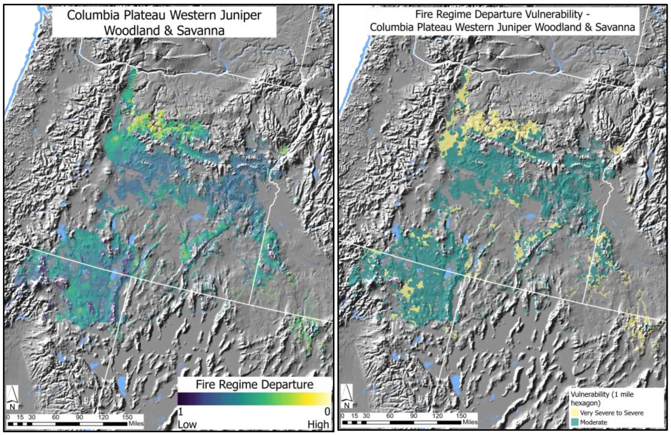
2.2. Measuring Climate Change Vulnerability

See the cited sources [14,15] for a detailed explanation of component exposure and resilience measures of the HCCVI. Table 1 summarizes the indicators used to measure the components of vulnerability for these woodland types. Each indicator was represented in mapped form, with mapped distributions of varying spatial resolution, from 800 m to 4 km pixel (0.2–988 acres) climate data to 30 m (0.22 acre) pixel raster data depicting sensitivity measures.
Indicators were applied through map overlays with each ecosystem distribution, then spatially averaged by a summary spatial reporting unit for each type (varying from 1 mile2 hexagon grid units). Climate exposure is a measure of anticipated climate stress introduced when comparing a future climate projection against a mid-20th century baseline. We characterized the baseline climate niche for each ecosystem type using observed climate data for the mid-20th century period and the potential/historical distribution of the type. Exposure measures were calculated based on changes in a type-specific subset of 19 bioclimatic variables derived from monthly temperature and precipitation data [20,21]. We estimated the overall exposure against our baseline period for projected future change (mid-21st century, RCP 8.5). Since methods and input data vary slightly for types treated here, see File S1 for type-specific details.
HCCVI measures of resilience address predisposing conditions—such as extant ecosystem stressors or natural abiotic or biotic characteristics of the type—that are likely to affect ecological responses of the natural ecosystem to changing climate. For example, the introduction of non-native species may displace native species and/or alter key dynamic processes such as wildfire regimes [22], and both could be exacerbated by climate change. These factors would describe relative climate change sensitivity for a given natural ecosystem type.
The HCCVI measures adaptive capacity considering the natural geophysical variability for the type’s distribution and/or the functional roles of species in the ecosystem type [14]. For example, a community type occurring in rugged landscape settings that naturally include many microclimates, or where types naturally include a high diversity of nitrogen-fixing species, may retain a high capacity to adapt to climate stress. The combination of sensitivity measures and adaptive capacity measures were averaged together per summary spatial reporting unit to establish an overall score for resilience.
As described in Figure 1, patterns of relative vulnerability in each type vary across its distribution, as depicted with a 1 mile2 hexagon. These patterns reflect differing degrees of relative severity measured by component index values for exposure and resilience. While per-pixel outputs are summarized along the 0.0–1.0 continuum, summary statistics for climate change vulnerability may be expressed using default break points with quartiles of each continuous measure to determine the range falling into each category (≥0.75 = Low = “<30% severity”, 0.5–0.75 = Moderate = “>30% severity”, 0.25–0.50 = High = “>50% severity”, and ≤0.25 = Very High = “>80% severity”). File S1 includes summary statistics of HCCVI results for these types using these standard thresholds [14].

2.3. Relative Climate Change Severity Applied to Adaptation Zonation

Adaptation zones aim to characterize substantial portions of each ecosystem type distribution where unique combinations of measures of climate exposure and resilience suggest appropriate responses by policymakers, planners, and managers. We used the climate change adaptation framework from Peterson et al. [13] to generally categorize adaptation strategies along a six-part continuum from 1—“Active Resistance” to 6—“Accelerated Transformation”. Each of the six generalized adaptation strategies emphasizes greater to lesser degrees of management to maintain historical structures and functions vs. advancing toward new structures and functions. “Passive Resistance” includes actions to passively maintain current/historical structures and functions. “Resistance” includes actions to improve the capacity of a system to return to the desired past or current structures and functions following a disturbance, to the extent possible, while recognizing some new elements are inevitable. “Autonomous Transformation” includes actions designed to facilitate the autonomous transition to new structures and functions. At the extremes, “Active Resistance” includes actions designed to actively maintain current/historical structures and functions, while “Accelerated Transformation” includes actions designed to more rapidly advance the transition towards new structures and functions.
Component HCCVI measures were evaluated using histograms of area for each ecosystem type scoring along the 0.0–1.0 continuum. In some cases, normal distributions are characteristic of a given measure; their continuous nature may preclude their use in zone definition. In others, bimodal or substantially skewed distributions suggest break points categorize the continuous distributions and simplify the results for zonation. Where bimodal distributions are evident, low points of each curve readily identify zonal breaks. In more common skewed distributions, steep slopes within the histogram also indicated logical zonal breaks. Often using natural breaks in the data, the continuous distributions of each measure were thresholded into two and sometimes three segments. Depending on the nature of a given exposure or resilience indicator, each was subsequently coded with “1”, indicating most favorable conditions, to “3”, indicating least favorable conditions.
Categorized exposure and resilience measures were then combined to identify unique combinations of measures that depict distinct zones for each ecosystem type across their entire distribution. Each zone was coded for the combinations of contributing indicators. For example, one could have “Exposure 3”, “Fire 2”, and “Invasives 1”, suggesting a zone made up of areas with very severe climate exposure (3) where high fire regime departure (2), and moderate invasive species abundance (1) are characteristic.

3. Results

Illustrating Climate Change Adaptation Zonation

Again, to illustrate our methodology, our results include one example—Columbia Plateau Western Juniper Woodland and Savanna—to illustrate the component steps of applying the HCCVI inputs and outputs for adaptation zonation. We then summarized the results for the assessed types. Illustrating both the continuous and segmented results for the climate exposure projected for Columbia Plateau Western Juniper Woodland and Savanna, 17% of its distribution is forecasted to fall within the “very severe to severe” category, and 83% in the “moderate to low severity” category (Figure 4). See the details in File S2. Climate exposure vulnerability pertains to the climate exposure measure for this type, as referenced in the generalized analytical flow depicted in Figure 1.
Figure 5 includes a histogram of climate exposure for the Columbia Plateau Western Juniper Woodland and Savanna distribution. One threshold within these data was identified to simplify the overall continuous distribution into two categories to assist with identifying adaptation zones.
Climate exposure measures, and the one or more categories identified for each type, initially determined the generalized adaptation strategy category from Peterson St Laurent et al. [13]. For example, areas scoring as very severe climate exposure suggested categorization under “5-Directed Transformation”, while portions scoring as low severity for climate exposure were initially categorized under “2-Passive Resistance”.
HCCVI factors for sensitivity and adaptive capacity can provide substantial insight and depth of information to augment the measures of exposure and define, or simply inform, zones where more specific management responses could be emphasized. In this example of Columbia Plateau Western Juniper Woodland and Savanna, just fire regime departure—one measure under sensitivity for the HCCVI—was segmented to initially define adaptation zones (Figure 6). In this case, just two categories defined “very severe-severe” vs. “moderate” fire regime departure.
The combination of segmented zones of exposure and fire regime departure results in 4 primary adaptation zones for this woodland and savanna type (Figure 7). These four mapped zones span the range of four of six generalized adaptation strategies of Peterson St-Laurent et al. [13]. They include “2-Passive Resistance”, occurring across some 63% of the type distribution and emphasizing maintenance of historical fire regime, to “5-Directed Transformation”, encompassing some 5% of the type distribution where both severe climate exposure and fire regime alteration force adaptive actions suited to a novel fire regime under much hotter and drier site conditions (Table 2).
In this example, additional HCCVI factors for sensitivity and adaptive capacity were held back from defining adaptation zones, but their maps could be used in combination with the four defined zones to further specify local adaptation responses. Figure 8 depicts three of these factors. Landscape condition depicts greater or lesser densities of fragmenting land use features, such as roads or intensive land uses [23], so adaptation zones overlapping this continuous map of values could consider the greater or lesser emphasis on restoring natural intactness and connectivity. In different areas within the four mapped zones, greater or lesser emphasis on treatments combatting invasive plant species is suggested [24]. The adaptive capacity measure of topographic roughness can be most importantly considered as being related to climate exposure measures [25]. Where zones 4 and 5 overlap with very flat landscapes, managers can anticipate the most rapid turnover in native species composition, implicating choices for the plant materials used in restoration. Similarly, the character of a given type could suggest a local modification to suggested adaptive strategies. This Columbia Plateau example includes both woodland and open savanna vegetation structure, depending on the local landscape and wildfire regime, so adaptive responses could vary by predominant vegetation structure within the same mapped zone.
Table 2 provides a high-level summary of the proportional areal extent for inputs and resultant adaptation zones for each of the pinyon pine and juniper woodland types. Detailed summaries for the adaptation zonation of these types are found in File S2.
Four of the six major adaptation categories are represented among these woodland types, with none falling at either extreme of 1: Active Resistance or 6: Accelerated Transformation. Fully 64% of the combined area of these types were categorized within 3: Resilience, suggesting—at least through the mid-21st century—a strong emphasis should be on “actions to improve the capacity of a system to return to desired past or current structures and functions following a disturbance to the extent possible while recognizing some new elements are inevitable” [11]. This was most pronounced among several types with a very high proportional area falling in this category, including Great Basin (94%), Colorado Plateau (93%), and Madrean (83%) pinyon-juniper woodland, as well as 84% of the Colorado Plateau Pinyon-Juniper shrublands. Again, many of the suggested management responses in these zones could concentrate on restoring or maintaining expected native species composition and natural dynamic processes.
About 23% of the combined area of these types was categorized under 4: Autonomous Transformation, suggesting “actions designed to facilitate the autonomous transition to new structures and functions” [11]. The highest proportional area in this category is found in Southern Rocky Mountain Pinyon-Juniper Woodland (94%), Southern Rocky Mountain Juniper Woodland, and Savanna (84%), Madrean Juniper Savanna (78%), and Rocky Mountain Foothill Limber Pine-Juniper Woodland (52%). Many of the suggested management responses in these zones could concentrate on restoring or maintaining natural landscape connectivity to facilitate the natural movement of native species. It could also include considerations of species plantings or substitutions where functional traits are favored over native species per se. Reconsidering prior assumptions about natural dynamic processes—like wildfire regimes—is suggested in these zones for these types.
About 3% of the combined area of these types was categorized under 5: Directed Transformation and suggests “actions designed to more rapidly advance transition towards new structures and functions” [11]. The highest proportional area in this category is found in Intermountain Basins Juniper Savanna (23%) and Madrean Juniper Savanna (22%). Many of the suggested management responses in these zones could concentrate on restoring natural landscape connectivity. In these areas, considerations of species plantings or substitutions where functional traits become more urgent. Reconsidering prior assumptions about natural dynamic processes—like wildfire regimes—is also most urgent in these zones for these types.
In contrast to these zones, about 10% of the combined area of these types was categorized under 2: Passive Resistance and suggests “actions to passively maintain current/historical structures and functions” [11]. The highest proportional area in this category is found in Columbia Plateau Western Juniper Woodland and Savanna (63%), our example used above for illustration. Many of the suggested management responses in these zones could concentrate on preventive measures like maintaining natural landscape connectivity. However, as noted above, there is quite a range of conditions suggesting more aggressive adaptation throughout the other 37% of this type’s distribution.
Overall, for three types, most or all the type distribution falls within categories of 2: Passive Resistance and 3: Resilience. These include Colorado Plateau Pinyon-Juniper Woodland (100%), Madrean Pinyon-Juniper Woodland (100%), and Columbia Plateau Western Juniper Woodland and Savanna (83%). All other types include no area scoring under 2: Passive Resilience, and more substantial proportions in categories 4: Autonomous Transformation and 5: Directed Transformation (Table 2).

4. Discussion

While traditional natural resource management has tended to be ‘retrospective’—utilizing knowledge of past and current conditions to inform today’s management actions—forecasting future conditions is increasingly required. While still important, it is no longer sufficient to assess current conditions and then decide what actions should be prioritized for the upcoming 15-year management plan. Forecasting is needed to determine the nature and magnitude of change likely to occur, so that this knowledge can be translated back to current decision-making timeframes.
This analysis, using component measures of vulnerability, suggests adaptation strategies that suit the character of the particular habitat or vegetation type. Looking out towards the mid-21st century, all types assessed here would benefit from resilience-based strategies, so these investments in the near term may limit the need for more extreme measures later in the century [26,27,28]. In just 10% of the combined area for these types, passive resistance strategies are suggested. This reflects the reality that while pinyon-juniper woodlands often occur in extensive and remote landscapes of the interior North American West, some process-altering forces—such as grazing effects and wildfire suppression—have been pervasive for decades [29]. But actions to maintain or restore resilience in these woodlands could include protection of remaining “old growth” stands while restoring natural wildfire regimes and tree canopy densities in surroundings [26].
Some 26% of the combined area of pinyon-juniper woodlands is likely to require increasingly aggressive forms of adaptation to conditions that are transforming to varying degrees by climate change and its interactions with other extant stressors [27,28]. Over the upcoming decades, as temperature and precipitation patterns change, models of wildfire regimes will need to be updated and customized to local conditions [29]. Monitoring for invasive plant expansion, such as from cheatgrass (Bromus tectorum) [30], effects of drought stress, and tree regeneration will all increase in urgency [31,32]. One can anticipate increasing losses of native taxa and so the retention or introduction of species with important functional traits will be needed. Therefore, knowledge of the functional roles played by native plant and animal taxa will be increasingly urgent to inform strategies for species selection in habitat restoration and maintenance [26,33,34].
Here we have demonstrated an analytical framework to map zones for climate change adaptation that should assist managers with this increasingly daunting task by supporting place-based vegetation management decisions. The results indicate highly varied patterns in mapped zones, but these zones should provide a practical input for allocating resources for conservation and land management. We anticipate that the application of similar information for other major forest, shrubland, and grassland types in the region would yield similar results.

4.1. Challenges Translating HCCVI Outputs to Adaptation Zones

Our study illustrates some of the challenges in applying our data to the purpose of mapping zones for adaptation. For example, the spatial distribution of both climate and non-climate stressors on vegetation varies considerably, so our task of simplifying mapped results to identify discrete “zones” was facilitated where distinct breaks in data existed. A bimodal distribution, or steep drop-offs in histogram outputs (Figure 5), offered ready opportunities for segmenting data to define zones. But where the demonstrated patterns were more continuous, more judgement was required that is inherently less repeatable.
Selecting among multiple factors for zonation introduces another challenging dimension to this process as the spatial overlap of factors can quickly generate numerouspotential zones, some of which occupy very small areal extents. We found that judgment and practical rulesets were required—such as merging potential zones with the most similar zones when they occupied <1% of the type distribution.
Additionally, no matter how well we understand ecosystem processes and functions, practical limitations arise with locating suitable indicator data for the climate vulnerability assessment, especially when attempting to measure conditions across the entire range of a given ecosystem type. Therefore, these limitations can also limit our ability to include important factors in adaptation zonation.

4.2. Advancing the HCCVI and Adaptation Zonation in Different Ecosystems

Looking beyond the upland ecosystem types treated here, we anticipate that both vulnerability assessment and adaptation zonation will encompass different component measures for climate exposure and resilience suitable for wetland, freshwater aquatic, and marine ecosystems. We anticipate that much additional effort is needed to better link climate trend data more directly to the most important ecological processes, such as hydrologic regime, fire regime, or biomass productivity, to provide more robust predictions. Similarly, some factors affecting resilience will change over the upcoming decades. Therefore, the ability to reliably forecast changing conditions—such as those resulting from species invasion or human development patterns—will add precision to overall resilience forecasts, and thus adaptation zones.
Still, other dimensions, such as the cultural dimensions of human presence in landscapes, as increasingly described as “socio-ecological systems” [9,11,35,36], can bring a rich perspective to adaptation zonation. While our approach aims to limit uncertainty by first assessing the natural habitat type, in subsequent steps, these outputs can be brought together with human dimensions to define zones within a given landscape of interest.

5. Conclusions

The challenges of climate change on the management of forest, shrubland, and grassland resources are emerging. It is becoming clear that—both in computer model projections and on the ground each growing season—the nature and intensity of climate stress varies substantially over space and time. While this fact on its own challenges conservation decisions, it often comes in a context where long-standing legacies of prior land uses have already compromised ecosystem functioning and integrity. Therefore, the many interactions of climate stress with other extant ecosystem stressors are generating a very complex map of emerging conditions for natural resource planners and managers. This is certainly the case among the vast landscapes supporting pinyon- and juniper woodlands across the western United States.
We believe that the analytical approach illustrated here with western forest and woodland types provides a practical basis for translating results of climate change vulnerability assessment into adaptation zones for major vegetation types and could be replicated anywhere worldwide. Our cases also include sufficient specificity to quantify areas impacted and costs associated with adaptive management responses. Continued investment in this analysis, encompassing more types and across spatial scales, should yield benefits to natural resource managers and conservation practitioners as they navigate the challenges posed by climate change over the upcoming decades.

Supplementary Materials

The following supporting information can be downloaded at: https://www.mdpi.com/article/10.3390/f14081533/s1, File S1: Proportional area for all components and composite HCCVI for each assessed ecosystem type. File S2: Proportional area and factors defining adaptation zones for each assessed ecosystem type (both supplied as separate file).

Author Contributions

Conceptualization, P.J.C.; Data curation, E.S.; Formal analysis, P.J.C. and E.S.; Funding acquisition, P.J.C.; Investigation, P.J.C.; Methodology, P.J.C. and E.S.; Project administration, P.J.C.; Software, P.J.C. and E.S.; Supervision, P.J.C.; Validation, P.J.C.; Visualization, P.J.C.; Writing—original draft, P.J.C.; Writing—review and editing, P.J.C. and E.S. All authors have read and agreed to the published version of the manuscript.

Funding

This research received the support of U.S. Department of Interior, Bureau of Land Management Cooperative Agreement Award number L20AC00540.

Data Availability Statement

Not applicable.

Acknowledgments

We wish to acknowledge the support of U.S. Department of Interior agencies, primarily the Bureau of Land Management, South-Central Climate Adaptation Science Center, U.S. Fish and Wildlife Service, and Department of Defense (through the Center for Environmental Management on Military Lands at Colorado State University) who have provided resources for this research. Numerous experts have provided reviews and insights throughout the design of this method and its implementation.

Conflicts of Interest

The authors declare no conflict of interest.

References

  1. Wells, P.V. Paleobiogeography of montane islands in the Great Basin since the last glaciopluvial. Ecol. Monogr. 1983, 53, 341–382. [Google Scholar] [CrossRef]
  2. Betancourt, J.L.; Van Devender, T.R.; Martin, P.S. (Eds.) Packrat Middens: The Last 40,000 Years of Biotic Change; University of Arizona Press: Tucson, AZ, USA, 1990. [Google Scholar]
  3. Swetnam, T.W.; Betancourt, J.L. Mesoscale disturbance and ecological response to decadal climatic variability in the American Southwest. J. Clim. 1998, 11, 3128–3147. [Google Scholar] [CrossRef]
  4. Comer, P.J.; Hak, J.C.; Seddon, E. Documenting at-risk status of terrestrial ecosystems in temperate and tropical North America. Conserv. Sci. Pract. 2022, 4, e603. [Google Scholar] [CrossRef]
  5. Foden, W.B.; Young, B.E.; Akçakaya, H.R.; Garcia, R.A.; Hoffmann, A.A.; Stein, B.A.; Thomas, C.D.; Wheatley, C.J.; Bickford, D.; Carr, J.A.; et al. Climate change vulnerability assessment of species. Wiley Interdiscip. Rev. Clim. Chang. 2018, 10, e551. [Google Scholar] [CrossRef] [Green Version]
  6. Millar, C.I.; Stephenson, N.L.; Stephens, S.L. Climate change and forests of the future: Managing in the face of uncertainty. Ecol. Appl. 2007, 17, 2145–2151. [Google Scholar] [CrossRef]
  7. Magness, D.R.; Morton, J.M.; Huettmann, F.; Chapin, F.S., III; McGuire, A.D. A climate-change adaptation framework to reduce continental-scale vulnerability across conservation reserves. Ecosphere 2011, 2, 1–23. [Google Scholar] [CrossRef]
  8. Chambers, J.C.; Bradley, B.A.; Brown, C.S.; D’Antonio, C.; Germino, M.J.; Grace, J.B.; Hardegree, S.P.; Miller, R.F.; Pyke, D.A. Resilience to stress and disturbance, and resistance to Bromus tectorum L. invasion in cold desert shrublands of western North America. Ecosystems 2014, 17, 360–375. [Google Scholar] [CrossRef]
  9. Schuurman, G.W.; Cole, D.N.; Cravens, A.E.; Covington, S.; Crausbay, S.D.; Hoffman, C.H.; Lawrence, D.J.; Magness, D.R.; Morton, J.M.; Nelson, E.A.; et al. Navigating ecological transformation: Resist–accept–direct as a path to a new resource management paradigm. BioScience 2022, 72, 16–29. [Google Scholar] [CrossRef]
  10. Peterson St-Laurent, G.; Oakes, L.E.; Cross, M.; Hagerman, S. R–R–T (resistance–resilience–transformation) typology reveals differential conservation approaches across ecosystems and time. Commun. Biol. 2021, 4, 39. [Google Scholar] [CrossRef]
  11. Galatowitsch, S.; Frelich, L.; Phillips-Mao, L. Regional climate change adaptation strategies for biodiversity conservation in a midcontinental region of North America. Biol. Conserv. 2009, 142, 2012–2022. [Google Scholar] [CrossRef]
  12. Lavorel, S.; Colloff, M.J.; Locatelli, B.; Gorddard, R.; Prober, S.M.; Gabillet, M.; Devaux, C.; Laforgue, D.; Peyrache-Gadeau, V. Mustering the power of ecosystems for adaptation to climate change. Environ. Sci. Policy 2019, 92, 87–97. [Google Scholar] [CrossRef]
  13. Füssel, H.M. Adaptation planning for climate change: Concepts, assessment approaches, and key lessons. Sustain. Sci. 2007, 2, 265–275. [Google Scholar] [CrossRef]
  14. Comer, P.J.; Hak, J.C.; Reid, M.S.; Auer, S.L.; Schulz, K.A.; Hamilton, H.H.; Smyth, R.L.; Kling, M.M. Habitat Climate Change Vulnerability Index Applied to Major Vegetation Types of the Western Interior United States. Land 2019, 8, 108. [Google Scholar] [CrossRef] [Green Version]
  15. Kling, M.M.; Auer, S.L.; Comer, P.J.; Ackerly, D.D.; Hamilton, H.H. Multiple dimensions of vegetation exposure to climate change. Clim. Chang. Biol. 2020, 26, 2798–2813. [Google Scholar] [CrossRef]
  16. Comer, P.; Faber-Langendoen, R.D.; Evans, S.; Gawler, C.; Josse, G.; Kittel, S.; Menard, M.; Pyne, M.; Reid, K.; Schulz, K.; et al. Ecological Systems of the United States: A Working Classification of U.S. Terrestrial Systems; NatureServe: Arlington, VA, USA, 2003. [Google Scholar]
  17. Comer, P.J.; Schulz, K.A. Standardized ecological classification for mesoscale mapping in the southwestern United States. Rangel. Ecol. Manag. 2007, 60, 324–335. [Google Scholar] [CrossRef]
  18. Rollins, M.G. LANDFIRE: A nationally consistent vegetation, wildland fire, and fuel assessment. Int. J. Wildland Fire 2009, 18, 235–249. [Google Scholar] [CrossRef] [Green Version]
  19. Comer, P.J.; Hak, J.C.; Josse, C.; Smyth, R. Long-term loss in extent and current protection of terrestrial ecosystem diversity in the temperate and tropical Americas. PLoS ONE 2020, 15, e0234960. [Google Scholar] [CrossRef] [PubMed]
  20. O’Donnell, M.S.; Ignizio, D.A. Bioclimatic Predictors for Supporting Ecological Applications in the Conterminous United States; US Geological Survey Data Series; United States Geological Survey: Reston, VA, USA, 2012; Volume 691. [Google Scholar]
  21. Oyler, J.W.; Ballantyne, A.; Jencso, K.; Sweet, M.; Running, S.W. Creating a topoclimatic daily air temperature dataset for the conterminous United States using homogenized station data and remotely sensed land skin temperature. Int. J. Climatol. 2015, 35, 2258–2279. [Google Scholar] [CrossRef]
  22. Weltz, M.A.; Spaeth, K.; Taylor, M.H.; Rollins, K.; Pierson, F.; Jolley, L.; Nearing, M.; Goodrich, D.; Hernandez, M.; Nouwakpo, S.K.; et al. Cheatgrass invasion and woody species encroachment in the Great Basin: Benefits of conservation. J. Soil Water Conserv. 2014, 69, 39A–44A. [Google Scholar] [CrossRef] [Green Version]
  23. Hak, J.C.; Comer, P.J. Modeling landscape condition for biodiversity assessment—Application in temperate North America. Ecol. Indic. 2017, 82, 206–216. [Google Scholar] [CrossRef]
  24. Hak, J.C.; Comer, P.J. Modeling Invasive Annual Grass Vulnerability in the Cold Deserts of the Intermountain West. Rangel. Ecol. Manag. 2020, 73, 171–180. [Google Scholar] [CrossRef]
  25. Loarie, S.R.; Duffy, P.B.; Hamilton, H.; Asner, G.P.; Field, C.B.; Ackerly, D.D. The velocity of climate change. Nature 2009, 462, 1052. [Google Scholar] [CrossRef] [PubMed]
  26. Folke, C.; Carpenter, S.; Walker, B.; Scheffer, M.; Elmqvist, T.; Gunderson, L.; Holling, C.S. Regime shifts, resilience, and biodiversity in ecosystem management. Annu. Rev. Ecol. Evol. Syst. 2004, 35, 557–581. [Google Scholar] [CrossRef] [Green Version]
  27. Rosenfeld, J.S. Functional redundancy in ecology and conservation. Oikos 2002, 98, 156–162. [Google Scholar] [CrossRef] [Green Version]
  28. Hansen, L.; Biringer, J.L.; Hoffman, J. Buying Time: A User’s Manual to Building Resistance and Resilience to Climate Change in Natural Systems; World Wildlife Fund: Washington, DC, USA, 2003. [Google Scholar]
  29. Jacobs, B.F.; Gatewood, R.G. Restoration studies in degraded pinyon-juniper woodlands of north-central New Mexico. In Proceedings of the Ecology and Management of Pinyon–Juniper Communities within the Interior West, Provo, UT, USA, 15–18 September 1997; RMRS-P-9. US Department of Agriculture, Forest Service, Rocky Mountain Research Station: Ogden, UT, USA, 1999; pp. 294–298. [Google Scholar]
  30. Roundy, B.A.; Vernon, J.L. Watershed values and conditions associated with pinyon-juniper communities. In Proceedings of the Ecology and Management of Pinyon–Juniper Communities within the Interior West, Provo, UT, USA, 15–18 September 1997; Monsen, S.B., Stevens, R., Eds.; USDA Forest Service, Rocky Mountain Research Station: Ogden, UT, USA, 1999; pp. 172–187. [Google Scholar]
  31. Breshears, D.D.; Cobb, N.S.; Rich, P.M.; Price, K.P.; Allen, C.D.; Balice, R.G.; Romme, W.H.; Kastens, J.H.; Floyd, M.L.; Belnap, J.; et al. Regional vegetation die-off in response to global-change-type drought. Proc. Natl. Acad. Sci. USA 2005, 102, 15144–15148. [Google Scholar] [CrossRef] [PubMed]
  32. Allen, C.D.; Macalady, A.K.; Chenchouni, H.; Bachelet, D.; McDowell, N.; Vennetier, M.; Kitzberger, T.; Rigling, A.; Breshears, D.D.; Hogg, E.H.; et al. A global overview of drought and heat-induced tree mortality reveals emerging climate change risks for forests. For. Ecol. Manag. 2010, 259, 660–684. [Google Scholar] [CrossRef] [Green Version]
  33. Hartsell, J.A.; Copeland, S.M.; Munson, S.M.; Butterfield, B.J.; Bradford, J.B. Gaps and hotspots in the state of knowledge of pinyon-juniper communities. For. Ecol. Manag. 2020, 455, 117628. [Google Scholar] [CrossRef]
  34. Díaz, S.; Cabido, M. Vive la difference: Plant functional diversity matters to ecosystem processes. Trends Ecol. Evol. 2001, 16, 646–655. [Google Scholar] [CrossRef]
  35. Lindner, M.; Maroschek, M.; Netherer, S.; Kremer, A.; Barbati, A.; Garcia-Gonzalo, J.; Seidl, R.; Delzon, S.; Corona, P.; Kolström, M.; et al. Climate change impacts, adaptive capacity, and vulnerability of European forest ecosystems. For. Ecol. Manag. 2010, 259, 698–709. [Google Scholar] [CrossRef]
  36. Cinner, J.E.; Huchery, C.; Darling, E.S.; Humphries, A.T.; Graham, N.A.J.; Hicks, C.C.; Marshall, N.; McClanahan, T.R. Evaluating Social and Ecological Vulnerability of Coral Reef Fisheries to Climate Change. PLoS ONE 2013, 8, e74321. [Google Scholar] [CrossRef]
Figure 1. The framework for the NatureServe Habitat Climate Change Vulnerability Index.
Forests 14 01533 g001
Figure 2. The mapped distributions of targeted pinyon-juniper woodland types in the western USA, including distributions in the states of OR—Oregon, ID—Idaho, MT—Montana, CA—California, NV—Nevada, UT—Utah, WY—Wyoming, CO—Colorado, NM—New Mexico, and AZ—Arizona.
Forests 14 01533 g002
Figure 3. (left) A photo of the Columbia Plateau Western Juniper Woodland and Savanna (credit: USDA Forest Service); (right) The mapped distribution of this type concentrated in Oregon and adjacent states in the western USA (by 1 mile2 hexagon).
Forests 14 01533 g003
Figure 4. The climate change exposure for the mid-21st century expressed along a continuum (left) summarized by a 1 mile2 hexagon for Columbia Plateau Western Juniper Woodland and Savanna, and (right) segmented zones with 83% scores as moderate-to-low severity and 17% scores as severe-to-very severe.
Forests 14 01533 g004
Figure 5. A histogram of the climate exposure for the Columbia Plateau Western Juniper Woodland and Savanna distribution, with thresholds indicated for zones (see Figure 4 right). The overall normal distribution is represented with a red line with a mean of 0.6918. The blue dashed lines delineate the four quartiles from 0 to 1 (0–0.25, 0.25–0.5, 0.5–0.75, and 0.75–1). No standard deviation lines are included in this graph. The data break between yellow and purple occurs at 0.49.
Forests 14 01533 g005
Figure 6. The HCCVI sensitivity measure of fire regime departure is displayed as a continuum (left) and segmented into “very severe to severe” vs. “moderate” departure (right) for the full distribution of Columbia Plateau Western Juniper Woodlands and Savanna.
Forests 14 01533 g006
Figure 7. Adaptation zones mapped from the combination of segmented measures of climate exposure and fire regime departure, segmented into four zones encompassing the continuum from Passive Resistance (zone 2: exposure—1, fire—1) to Directed Transformation (5: exposure—3, fire—3) strategies should be emphasized.
Forests 14 01533 g007
Figure 8. The selected component measures of climate change sensitivity, including landscape condition and invasive species, for adaptive capacity, and topographic roughness; each is to be used for refinement of adaptation strategies within each mapped zone.
Forests 14 01533 g008
Table 1. The HCCVI criteria and data sets were used to measure exposure and resilience, the latter with those nested measures for sensitivity and adaptive capacity. See Comer et al. [14] for a detailed explanation of these data sets.
Climate ExposureResilienceSensitivityAdaptive Capacity
Climate change relative mid-20th century baseline
Effect of climate change on key dynamic ecological process
Combined results from Sensitivity and Adaptive CapacityDisruption of Biotic ProcessBiotic Components
Landscape ConditionDiversity within Functional Species Groups
Invasive speciesKeystone Species Vulnerability
Insect or disease riskAbiotic Components
Environmental DegradationTopographic Roughness (topoclimate variability)
Fire Regime Departure
Table 2. Adaptation zones for pinyon-juniper woodland types are summarized by area falling into each adaptation strategy [13].
Terrestrial Ecological Systems
Pinyon and Juniper Woodlands
Potential Area
(mile2)
% of All 1: Active Resistance2: Passive Resistance3: Resilience4: Autonomous Transformation5: Directed Transformation6: Accelerated Transformation
Colorado Plateau Pinyon-Juniper Woodland17,52535 7%93%
Great Basin Pinyon-Juniper Woodland956219 94%5%1%
Columbia Plateau Western Juniper Woodland and Savanna47289 63%20%12%5%
Southern Rocky Mountain Pinyon-Juniper Woodland584812 94%6%
Southern Rocky Mountain Juniper Woodland and Savanna41188 12%84%4%
Madrean Pinyon-Juniper Woodland (USA only)628512 17%83%
Madrean Juniper Savanna (USA only)11942 78%22%
Inter-Mountain Basins Juniper Savanna6341 50%27%23%
Rocky Mountain Foothill Limber Pine-Juniper Woodland6131 44%52%4%
Colorado Plateau Pinyon-Juniper Shrubland1470.29 84%15%1%
All Types Combined50,657100 10%64%23%3%
Disclaimer/Publisher’s Note: The statements, opinions and data contained in all publications are solely those of the individual author(s) and contributor(s) and not of MDPI and/or the editor(s). MDPI and/or the editor(s) disclaim responsibility for any injury to people or property resulting from any ideas, methods, instructions or products referred to in the content.

