Article

Impact of Repurposing Forest Land on Erosion and Sediment Production—Case Study: Krupanj Municipality—Serbia

Institute of Architecture, Urban & Spatial Planning of Serbia, 73 Bulevar Kralja Aleksandra Blvd., 11000 Belgrade, Serbia
*
Author to whom correspondence should be addressed.
Forests 2023, 14(6), 1127; https://doi.org/10.3390/f14061127
Submission received: 18 April 2023 / Revised: 19 May 2023 / Accepted: 25 May 2023 / Published: 30 May 2023
(This article belongs to the Special Issue Forest Hydrology under Climate Change)

Abstract

:
Erosion is one of the main causes of soil degradation and sediment production. The amount of eroded material that reaches rivers and lakes depends on the terrain but also on the climatic and hydrological characteristics of the basin, as well as the applied land management method. The intensity of sediment production is in direct correlation with the land use type. Repurposing forest land as mining, urban and infrastructural development areas, etc., significantly affects sediment production. Shrinking of forests and unplanned agricultural production are just some of the factors that intensify erosion processes and increase the amount of eroded material, also triggering climate change and the onset of prolonged dry and rainy periods, which increase the risk of erosion in sloping terrain and intense sediment production. The paper presents the correlation between the change in the forest land use method, on the one hand, and soil erosion and sediment production, on the other, by analysing segments of river basins in the territory of the Serbian Municipality of Krupanj. The modelling of sediment production was based on data collected from the experimental territories. The method of erosion potential, data analysis, and procession in GIS surrounding were used for calculating sediment production in the experimental areas. The greatest loss of soil was perceived in the terrain with little or no vegetation on steep slopes covered with material prone to water erosion. The smallest production of sediment was noted in the terrain with vital forest vegetation. The results received point to the heterogeneous estimates of land loss, enabling the modelling of sediment production in wider basin areas and the analysis of the impacts of different land management factors on the erosion processes.

1. Introduction

Land repurposing increases the risk of erosion and sediment production [1,2]. Forest degradation caused by urban, mining, and infrastructural developments has a significant impact on the appearance of eroded material and transport towards rivers and lakes, with all the implications for space and the environment [3,4,5,6,7,8]. Unplanned management of forest and agricultural resources has an unfavourable effect on soil quality and the ability to defend against erosion [9,10]. Forest-cutting activities on steep terrains increase the destruction of the surface layers of forest soil, which results in the appearance of great quantities of sediment [11].
On the European continent, water erosion is one of the main causes of land resource degradation. Around 15% of the total land in Europe is affected by water erosion [12], while the estimated annual land loss in the countries of the European Union is some 2.5 t/ha [13]. Almost 3% of the territory of Serbia is affected by excessive erosion; 7% is prone to severe erosion, 12% is affected by moderate erosion, 25% by rather weak erosion, and 52% by extremely weak erosion [14], which means that around 8 million cubic metres of eroded material end up in rivers and lakes. The loss of land goes beyond the political and administrative borders of Europe and stretches across the entire continent’s surface. The intensity of the erosion processes is more dominant in warmer parts of Europe, which does not decrease the constancy of these phenomena in the north of Europe [15].
Intensive agricultural production, farming of sloped land, raising root crops on steep terrains, overgrazing, etc., increase the risks of land erosion [16]. Due to negative terrain-related, geological and climate characteristics, agricultural land with scant vegetation cover or no vegetation at all is a type of soil susceptible to the destruction of the land structure by means of raindrops and the development of water erosion [17]. In addition, large mining complexes have a significant impact on landscape devastation in general, especially on the appearance of gully erosion and a significant production of eroded material, while the construction of infrastructural facilities (roads, railroads, transmission lines, ski resorts) change the land use and require clear cutting, use of heavy construction machinery, and the reduction in the growing stock [18].
The development of mountain tourism and the construction of skiing infrastructure is another example of a possible negative impact of changing land use. Given that ski resorts are built at higher altitudes and steep slopes, the construction activities and the use of ski runs and accompanying infrastructure can result in the total destruction of the built ski runs and the degradation of the wider area [11]. Theoretical and practical possibilities of restoring the eroded terrain in ski centres of Serbia were analysed by Ristić [19].
Implementing small hydropower plant projects has revealed the problems during the construction and subsequent use. Full spring and river water intake, landslides, the appearance of gullies, and space degradation are only a few of the possible negative effects of implementing such projects [20].
Soil erosion is one of the main causes of land degradation, as well as the production of sediments [2]. In addition to the loss of surface organomineral soil layer, production of sediments, torrential flooding, the silting of the water supply accumulations, roads, railroads, and other infrastructural facilities by erosion sediments enriched with suspended matter is a significant contribution to unfavourable characteristics of erosion processes [21]. The climate changes that have been gaining in intensity in the past two decades have resulted in great oscillations of precipitation, distribution, and intensity; oscillations in air temperature; wind strength, etc., in the territory of the Krupanj Municipality, as well as globally [22].
The aim of this paper is to present how the scope and significance of the above effects are analysed and determined using a specific example and a specific space, creating in the process a basis for defining optimal anti-erosion and planned protection measures.

2. The Initial Position—A Case Study

2.1. The Basic Space Use

The Krupanj Municipality, located in the west of Serbia, on the right bank of the river Drina, has been chosen as the case study. Due to its specific hydrological, geomorphological, and climate characteristics, it suffered considerable effects during the floods that occurred in Serbia in 2014. It has a surface of 342 km2 and a population of 17,860. The Municipality centre is located in a basin, at an altitude of 289 m above sea level (ASL), and is surrounded by the mountains Boranja, Jagodnja, and Sokolska, with a height of app. 1100 m ASL. The rivers Bogoštica, Čađavica, and Kržava flow through Krupanj [
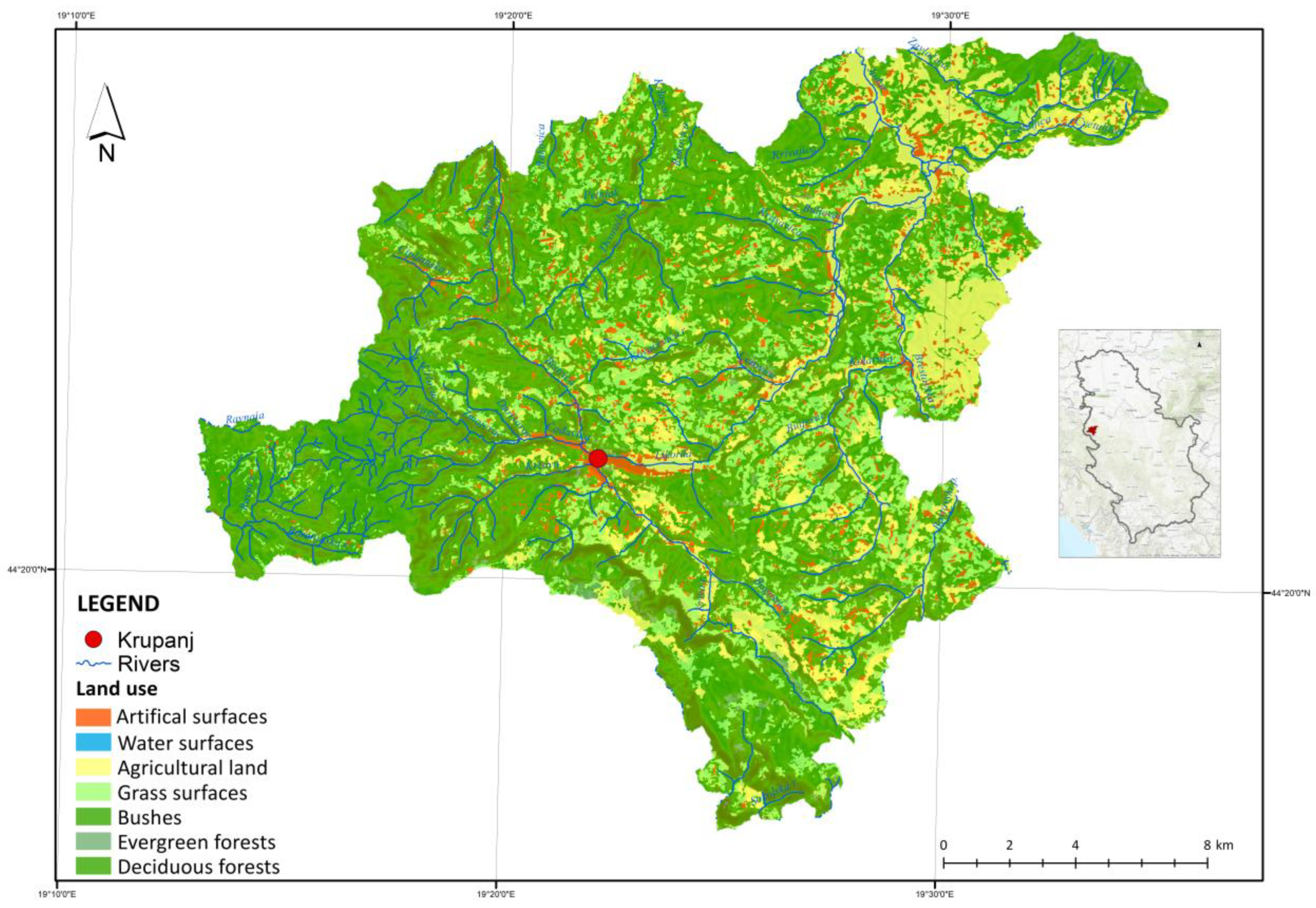
23]. The greatest percentage of the Krupanj Municipality territory is made up of agricultural land, app. 55%, followed by forests and forest land, app. 40%, with the rest being meadows and pastures. Figure 1 shows land use in the Krupanj Municipality.
The growing stock consists of a mixture of beech, oak, and silver fir forest stands, while the highest altitudes of the Municipality mostly have pure evergreen stands. State-owned forests are made up of beech stands, which are the most widely distributed, followed by oak, black locust, and pine stands. The forests in the private sector (mostly beech stands) are of poorer quality, with a great many small land parcels adjacent to agricultural land. Low vegetation, mushrooms (penny bun and foxglove), as well as wild fruit species (apple, pear, sweet cherry), are some of the plant species found in the forests of the Krupanj area [23].
Of the total agricultural land, 38.03% are farming fields, 6.95% are orchards, 0.15% are vineyards, 3.37% are meadows, 9.84% are pastures, and 77% of the total agricultural land resources are used as orchards and farming fields. The dominant cultivated fruit species include raspberry, plum, and blackberry, while the potato is the most cultivated farming species. The other cultivated species include sweet cherry, wild strawberry, wild blackberry, wild peach, apple, pear, cherry, tomato, pepper, beans, peas, cauliflower, wheat, corn, barley, oats, etc. [23].
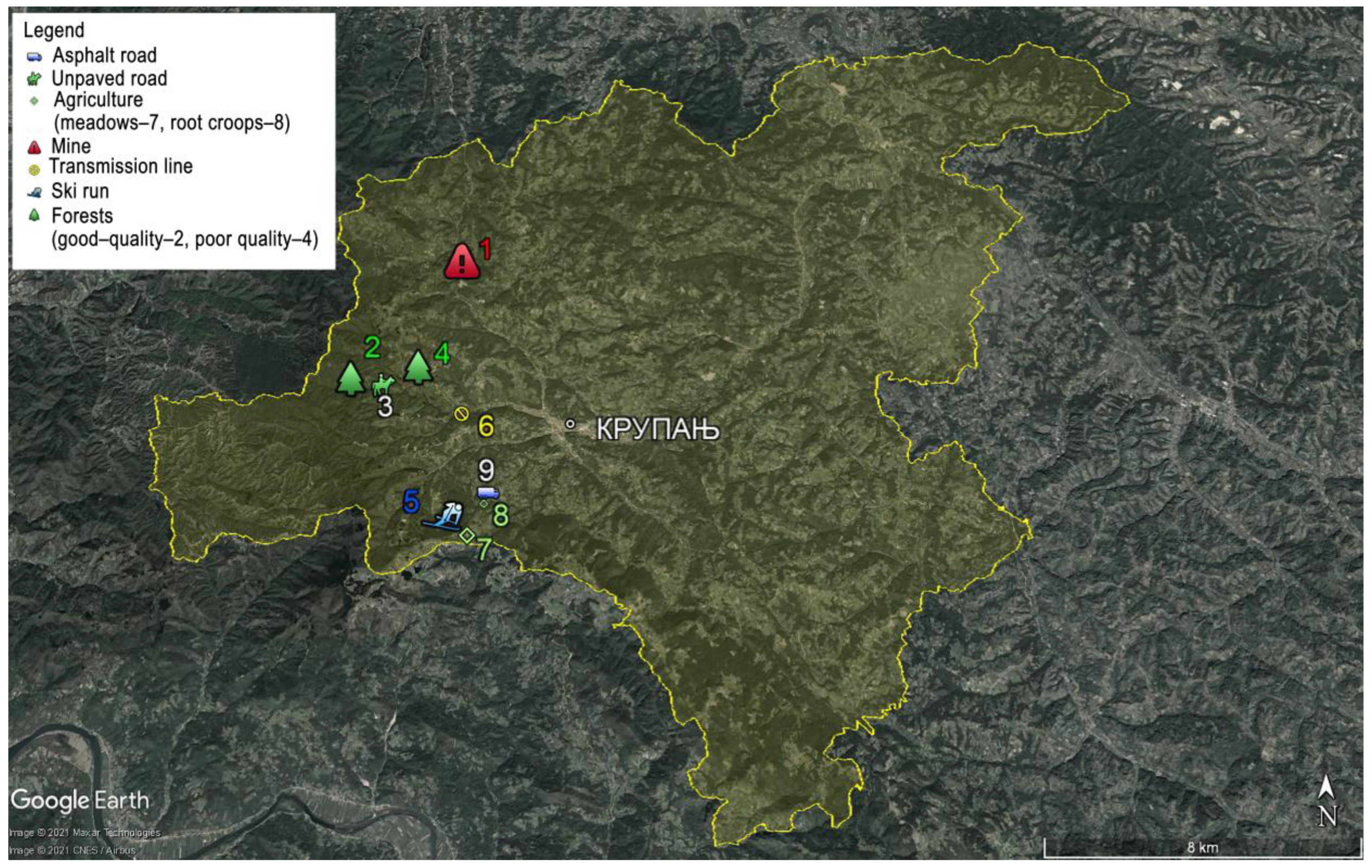
The mining infrastructure in the Krupanj Municipality includes the lead and zinc foundry, while the antimony mine is the most significant from the standpoint of erosion processes and sediment production. In the 1980s, the mines were closed without any reparation and recultivation of the degraded surfaces, i.e., the flotation landfill. Due to the great floods of 2014, the tailings pond dam burst, resulting in the leakage of toxic materials (lead and arsenic) and sediments into the rivers Korenita, Jadar, and Drina.
The road infrastructure in the Krupanj Municipality has a total of app. 692 km and takes up the surface area of app. 4.12 km2. It is made up of hard-surfaced and unpaved roads. Some forests and other unpaved roads turn into surface waterways as a result of high precipitation levels, causing land gully erosion. Due to surface water and groundwater infiltration, soil mass damping and saturation have occurred, resulting in the destruction of the soil structure, the appearance of landslides, land mass collapsing, subsidence, and land separation. Over the years, as a result of extensive rainfall, soil erosion, landslides, and land collapsing, the poor state of the roads in the Krupanj Municipality has become worse.
The electrical power lines (transmission lines) run across the Krupanj Municipality with a total length of 34.12 km, a surface area of 2215 km2, and protective transmission line corridors, which make up 0.65% of the total territory of the Krupanj Municipality. Planning the construction of electrical power facilities changes the land use, and the defined type of construction and maintenance affects space, i.e., the land resources. The electrical power facilities and their routes are constructed and maintained using measures including forest cutting, routing across agricultural land, digging up soil in order to put the pylons in place, use of machinery, etc., during construction and subsequent use. Clear forest cutting, as well as the use of heavy machinery on steep terrains, increases the risks of erosion processes and sediment production. Possible implications of using heavy mechanisation and related forest management challenges were addressed in certain research papers [25,26,27,28].
Small hydroelectric plants have not been built in the Krupanj Municipality, but a total of seven are planned to be constructed. The experiences of planning and constructing (use) of hydroelectric plants in Serbia have shown that, in most cases, large degradation processes take place during construction, as well as subsequently, when they are in use. Full waterway intake, the destruction of protected plant and animal species, as well as the rest of the flora and fauna; the appearance of landslides, erosion, and the production of great amounts of sediments; the destruction of the landscape, etc., are some of the consequences of constructing certain small hydroelectric plants.
Mount Jagodnja has a ski resort, which currently has ski runs, sleighing grounds, and a ski lift to transport the skiers. Jagodnja’s peak, Mačkov Kamen, is at an altitude of 923 m ASL. The length of the ski runs stands at app. 600 m, while the paths are app. 30 m long. In order to build a ski resort with the accompanying facilities, a change was made in land management, i.e., building certain facilities meant repurposing other types of land as construction land. During the construction of the ski run and the cable, the slope was routed, trees were cut, and stumps were removed. At the time, no works were conducted to prevent erosion processes from occurring on the ski run. The ski run is not in use, which allows grass and bush vegetation to grow and develop unimpeded.

2.2. Natural Characteristics

The territory of the Krupanj Municipality is affected by the moderate continental climate, with an average annual air temperature of 10.1 to 12.0 °C and an average annual precipitation level of 960 mm. The precipitation maximum of 110 mm is reached in September, while the minimum of 44 mm is reached in winter months. The average precipitation level for the vegetation period (March–September) stands at 524 mm, and the number of days with precipitation at 195. The annual number of days with snowfall stands at 32 [29]. The greatest amount of show in Krupanj falls in January (172 mm), February (128 mm), and December (127 mm). The number of showy days in January is around 10, in February around 8, and in December around 7. Show melt in the territory of the Krupanj Municipality does not pose a direct risk of triggering erosion processes [30]. The higher mountain areas (Mount Sokolska and Jagodnja) are richer in precipitation than the lower-altitude settlement areas, which is the basis for positive hydrological characteristics of the wider area (the density of the hydrographic network is 0.96 km/km2), from the standpoint of water supply, and negative ones from the standpoint of land erosion, landslides, torrential floods, etc. The mountainous environment with a specific altitude results in local air flow and more precipitation, especially during the summer (303 mm), with June having 124 mm of precipitation, while the height of precipitation in the winter is considerably lower, standing at app. 195 mm for the period between 1985 and 1996 [23]. Dominant winds blow from east and southwest and are of weak to medium intensity (4.4 m/s–6.7 m/s), therefore not affecting the forest vegetation. Due to the neighbouring mountains, the wind in Krupanj does not trigger eolian erosion processes [29,31].
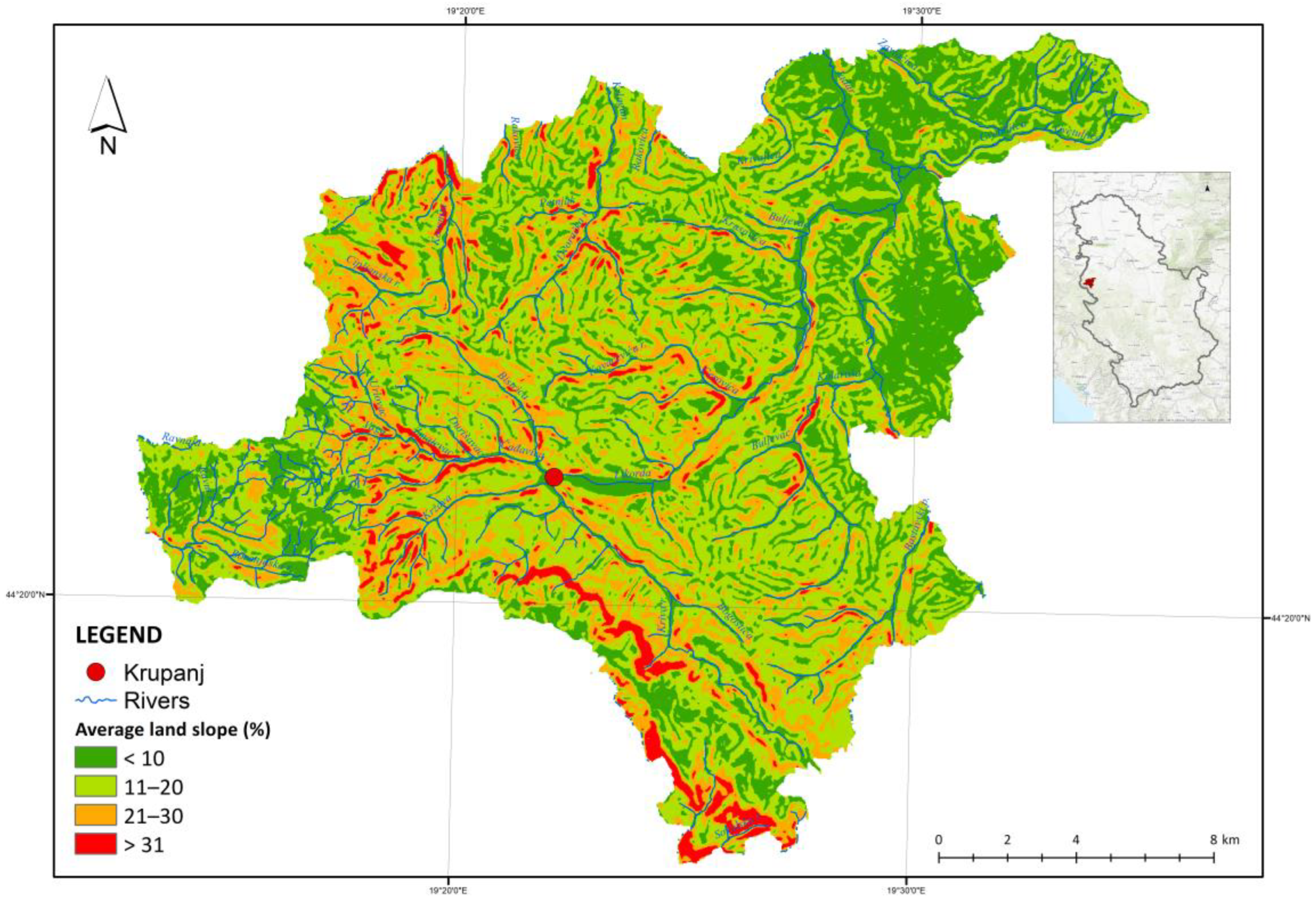
The Municipality relief is of the hill-and-mountain type, and in the valleys of the rivers Likodra and Jadar, it is the lowland type. Krupanj is situated in a structural basin surrounded by the mountains Boranja, Jagodnja, and Mount Sokolska, at an altitude of 289 m ASL. The highest peak of the Rađevina area is Rožanj, with an altitude of 973 m ASL on Mount Sokolska. The rivers Bogoštica, Kržava, Čađavica, and Brštica, which form the river Likodra, gravitate and flow through the town of Krupanj. From Krupanj, Likodra flows northeast and into the river Jadar, the biggest river in the area, at the village of Zavlaka. The Krupanj Municipality waterways belong to the river Drina drainage basin. The permanent and temporary waterways make the Drina very rich in waterways. The surrounding hills and mountains supply water to the following rivers: Bogoštica, Kržava, Čađavica, and Brštica. These rivers form Likodra near the town itself. From Krupanj, Likodra flows northeast and into the river Jadar, the biggest river in the area, at the village of Zavlaka. The erosion processes are pronounced, and the composition of the geological material, the terrain inclination, and the forest cover help along. In the Krupanj Municipality, a large portion of the territory is made up of dips of up to 20%, while dips of up to 21% make up a considerable share of the surface area. Such a terrain configuration, in addition to a significant impact on the waterways, results in and proves the occurrence of frequent floods and the production of considerable amounts of erosion sediments [23].
The geological material is made up of granodiorites, around which is an area of contact metamorphic rocks, diabase, hornstone, quartz conglomerates, shale stones, and sandstones. The most frequent are granodiorite masses on which potentially nutritious soils favourable for plant production are formed [23]. World Reference Base for Soil Resources (WRB) was used in the analysis of the land type; it is an international classification system used for the comparison with the national classification system and for defining and understanding land science terms used in the land management and protection on a global scale [32]. The pedological characteristics point to the following types of soil:
  • Haplic Cambisol (Dystric)—acidic brown soil on granites and granodiorites are the dominant type in this area. The favourable water and air regime allows a mechanical composition defined as light and sandy. This type of soil is located under the hill beech forest and is characterised by high fertility, which makes it suitable for most forest species;
  • Haplic Luvisol (Epidystric)—the evolution of acidic brown soils results in illimerised acidic brown soil, which takes up less surface area. Oak stands are mostly found on it, while it has secondary importance for beeches;
  • Leptic Cambisol (Eutric, Clayic)—brown soil, which is found on bituminous and banked limestone, is characterised by lesser depth and a relatively high share of organic matter. Its chemical characteristics make it similar to rendzina, but they are different in terms of mechanical composition as it has the character of clay loam;
  • Haplic Cambisol (Dystric, Siltic)—acidic brown soil on Paleozoic shales is formed on acidic rocks with a very shallow humus layer with unfavourable chemical and mechanical characteristics; therefore, it has little production value;
  • Haplic Cambisol (Dystric, Skeletic)—brown acidic soil on sandstone is characterised by a pronounced acidity and is formed as a shallow soil with a skeleton, which puts it in the category of soils with good water and air regimes of good production value;
  • Haplic Planosol—the soil with unfavourable physical characteristics and a poor water and air regime; parapodzol (pseudo-clay) is a low-fertility soil. The main vegetation growing on it is made up of oak and common hornbeam forests;
  • Haplic Fluvisol—alluvial soil occurs in the river Jadar valley as an alluvial sediment. It is a young sediment made by frequent flooding. The groundwater, which is very near the surface, makes this soil characteristic since, during droughts, the water supply to the vegetation is very good, giving the plants enough moisture at times of drought [33,34].

3. Method

The development of the erosion processes and the production of sediments were analysed by detailed observation of the terrain, i.e., the surfaces where land use was changed, as well as the remaining forest, agricultural, and other surfaces where land use was not changed, and which are presented as indicators of sorts. Through the terrain research of the territory of the Krupanj Municipality, characteristic sample surfaces were selected by type of industrial activity, i.e., the facilities located on them: mining, road and railroad infrastructure, electric power facilities, and ski runs. In addition to the territories with different industrial activities, characteristic forest and agricultural surfaces were also analysed (Figure 2).
Surface measurements were conducted on the analysed sample or characteristic surfaces. In order to identify and measure the surfaces and inclinations, topographical maps of a scale of P = 1:25,000, Google Earth, and data processing software QGIS and AutoCAD were used. Land uses were taken from orthophoto maps, planning documents, land registry, and by observing the terrain. Terrain measuring by means of measuring tape and digital laser meter was conducted to measure the depth of the furrows, the height of the sediments at partitions and recipients, and the production and total production of sediments was established by calculations using the erosion potential method for sediment production [35].
Determining the condition, erosion intensity, climate, and relief characteristics is the basis of the erosion potential method. The most important parameter in defining the intensity of erosion is the erosion coefficient Z, the dominant parameter of the erosion potential method. Drawing up a qualitative–quantitative erosion map enables the calculation of erosion sediment production [35].
The experimental parts of the river basin are certain types of soil, i.e., the purposes and uses of space. Through terrain work, the characteristic (experimental) surfaces were identified, followed by the measurement of the basic parameters necessary to calculate sediment production. The experimental surfaces were further divided into good- or poor-quality forests, root crops and meadows, mine tailings ponds, hard-surfaced and unpaved roads, the transmission line route, and the ski run.
Figure 2. The locations of the experimental surfaces (Google Earth Pro modificated by author) [36].
Forests 14 01127 g002
The forest resources in the Krupanj Municipality were divided into two categories—good-quality forests (high forests originating from seed or planted seedlings, high-quality autochthonous species, healthy trees with large growth increase and dense canopy) and poor-quality forests (low, coppice forests, trees of poor health, sparse trees, small growth increase, weed trees). The state-owned forest stands are mostly of good quality. The criteria for the selection of locations of experimental surfaces were the type of stand, dip, and access roads, i.e., the locations with greater average dips and altitudes were selected in order to obtain the same or higher values by modelling the sediment production for the entire Krupanj Municipality. The sizes of all the surfaces, as well as forest stands, are 1 ha, while the locations of sample surfaces are presented by means of coordinates in Table 1.
Agricultural land is the dominant class of land use in the territory of Krupanj. The cultivated species predominantly include root crops, while the meadows and pastures make up a small portion of the agricultural land. The choice of defining the surfaces for the purposes of calculating production was reduced to agricultural surfaces (root crops) and agricultural surfaces (meadows). The locations with greater dips were selected. Regarding root crops, those cultivated down the slopes were chosen as this type of land cultivation is prevalent in farming (Table 1). The production of raspberries, the most developed agricultural activity in this area, is performed by farming down the slope on surfaces ranging in size from 1 are to one or more hectares. Other crops are also cultivated on flatter and lower terrains, e.g., corn, etc.
The tailings pond of the abandoned mine was selected as a sample surface (Table 1). The main characteristic of this tailings pond is great sediment production prior to the tailings pond recultivation. The current state, i.e., the facilities constructed, fully protects this surface from the erosion processes. In addition to the production of polluted sediment, the water that rinsed the toxic material (see in [37,38]) from the tailings pond by transporting it downstream into the lower sections of the river basin was a big problem in this part of the basin. The calculation of the sediment production was modelled for the case before the construction of the facilities, i.e., before the recultivation of the abandoned tailings pond “Stolice”.
By observing the terrain of the Krupanj Municipality, problems were identified with respect to the erosion processes, especially regarding the road infrastructure in the cases of unpaved dirt and forest roads. These problems were especially pronounced on higher and steeper terrains, where forest cutting is the main industry. During the extraction of the trees, forest roads are damaged, and erosion processes occur. In addition to the erosion caused by exploiting the forest resources, also observed were the processes of furrow erosion on unpaved roads at greater inclinations. This, therefore, was the main criterion for locating the experimental surface of field and forest roads (Table 1). In selecting the locations of hard-surfaced asphalt roads, the main criteria were the erosion processes and reparations conducted in the immediate vicinity of the roads because the degradation processes do not occur on the roads themselves but in their immediate proximity. The location of the asphalt road is at a location where the gabion support wall was constructed to prevent a landslide from forming, i.e., to enhance the stability of the slope.
The transmission lines in the Krupanj territory run across nearly all types of land with different uses. They are located in the steeper and higher sections, as well as in the flatter, lower ones. The criterion for the selection of a location was regarding the use of the land below a transmission line to include multiple types of use on the experimental surface (Table 1). In principle, the current state of use of the land below transmission lines only has administrative restrictions, whereas, on the ground, the land is similarly used since, at the locations without transmission lines, the similarity is greatest between the agricultural and construction land. The forests located below transmission lines are different from the good-quality forests (poor composition and structure), and poor maintenance of transmission line routes are favourable for measures used in fighting soil erosion.
The complexes of the ski centre “Mačkov Kamen” are located at a relatively low altitude. Table 1 shows the location of the ski centre with its coordinates. It consists of one ski run and one ski lift, which have not been used for a long time. As a result, the vegetation on the ski run is developed and consists of grass and bush species. Next to the ski centre is a hotel-type structure that is also out of use. Given that the climate has changed considerably during the last decade, resulting in changes in the precipitation regimes, a consequence of this is a change in the elevation of the snowfall to considerably higher altitudes than the altitude of the ski centre “Mačkov Kamen”.

4. Results

Below are the results of the sediment production calculations for the selected surfaces in the Krupanj Municipality. The experimental fields differ in terms of land use and management. The sizes of the sample surfaces are homogeneous; in selecting the locations taking into account the dip, the method of the same or greater dips compared to the entire Krupanj territory was used for the same or similar types of land use. The main characteristic of the selected sample fields is identifying and non-identifying the erosion sediment production. In the analyses of the management and use of space for large basins, a detailed investigation is a comprehensive terrain work and a long process. Calculating the quantity of sediment production for the experimental surfaces enables modelling land loss for the parts of basins or the entire basins with the same or similar characteristics. A conclusion can be drawn from the above that such a model of calculating production increases the risks of certain errors. They can primarily appear with surfaces that differ in terms of dip, slope length, exposition, and microclimates. The positive effects of such a model are the estimates of the total quantity of material production based on the data, i.e., the results of the sediment production obtained from the experimental surfaces for certain conditions, purposes, uses, reliefs, and climates. In addition, this method is the basis for mapping the data on sediment production for the basin in question, other basins, or parts of basins with similar or the same inputs. Selecting a larger number of sample surfaces, i.e., through the research results relevant to the basin parts in question, can serve to create a database and unique collections, which can be used in the assessment of risks of the appearance of erosion processes or in envisaging the measures and works aimed at preventing and repairing the adverse effects of land resource degradation. Moreover, another important aspect is the understanding of the interaction of the obtained results, envisaged measures, and global climate changes, seen in the appearance of long rain and drought cycles.
The Krupanj Municipality is a very specific area; in addition to a very broadly distributed hydrographic network, it is an area where floods that cause a lot of material damage are frequent. Furthermore, great amounts of erosion sediment cause damage to the infrastructural facilities. The Krupanj Municipality needs continued annual repair of the damaged waterways, basins, roads, and other facilities. The territory of Krupanj sees various forms of negative land resource use, which, on the one hand, increases the risk of erosion processes, torrential floods, and material damage; on the other hand, we have examples of good practices for managing forest and agricultural land. In addition to tall good-quality forests, degraded poor-quality forests, and agricultural surfaces with various crops and farming methods, the Krupanj territory also has abandoned mines and ski centres, as well as other infrastructural facilities. All the said parameters identify this area as very good for research and modelling sediment production.

4.1. The Erosion Coefficient Z

The analysis, i.e., the calculation of the erosion coefficient for a given area or basin, is the degree of severity of the erosion processes for the examined territory. For each erosion category, the severity of the erosion is defined, with the associated erosion coefficient Z—Table 2. The value of the erosion coefficient is obtained in accordance with Theorem 1, and it is necessary to calculate the sediment production from the experimental surfaces and the total amount of sediment [39].
Z = Y · X · α · φ · I s r
Theorem 1.
Y is the soil resistivity coefficient; it represents the reciprocal value of the erosion resistance value and depends on the geological material, climate, and pedology. X·α is the basin protection coefficient; it represents the coefficient relating to the protection of soil from atmospheric effects and erosion forces in natural conditions X, or artificially created conditions, anti-erosion, technological, or biological works α. φ is the number equivalent of the visible erosion processes in the basin or the surrounding area (Table 3). Isr is the mean basin dip (%) (Figure 3) [39].
One of the more important parameters from the standpoint of soil erosion and sediment production and transport is the terrain dip. Figure 3 shows the dips for the entire territory of the Krupanj Municipality. Moreover, data on the land slope in the total territory of the Municipality of Krupanj as per land purpose shown in Figure 3 are elaborated further in the text, while the listed slopes of experimental surfaces are produced arithmetically. It is evident that the areas with the greatest terrain dips are found along the edges and the central zone, i.e., the dip is decreasing from the west to the east.
The data from Theorem 1 are shown in Table 3. Suitable parameters have been assigned to the selected experimental surfaces in line with the tables from the selected literature [39]. In order to calculate the coefficient Z, it is necessary to precisely understand all the aspects of the terrain research and the available literature for the purposes of suitable assignment of appropriate values to the selected surfaces.
The analysis, synthesis, and processing resulted in the erosion coefficient Z for the selected surfaces, based on which the erosion processes were categorised (Table 4) in line with said classification from Table 2. It can be concluded that the erosion processes are most intensive on surfaces with greater inclinations and without a protective vegetation cover, such as the mine tailings pond and unpaved forest roads, made and damaged during the cutting and extraction of trees. The erosion processes decrease progressively as the vegetation increases. It is evident that the erosion processes are at their weakest on the terrains with forest resources that are used and managed suitably and in a planned fashion.

4.2. Calculating the Sediment Production—The Erosion Potential Method

Analysing, researching, and measuring the parameters in some basins in the Republic of Serbia over many years was the basis for the development of the erosion potential method [14]. In engineering practice, this method is a standard in the analysis of erosion process problems and the appearance of torrential flows, as well as the drawing up of technical documentation and other important water economy-related documents. It has been used for many decades in Serbia to process data related to soil erosion, where the coefficient Z is an important element [14]. The calculation of the sediment production is performed following the formula in Theorem 2, while the results of the research are shown in Table 4 and Table 5.
W g = T · H g o d · π · Z 3 · F m 3 g o d
Theorem 2.
T is the temperature coefficient; Hgod is the mean annual precipitation quantity, 960 m m g o d ; π is Ludolph’s number (Archimedes’ constant) 3.1415; Z is the erosion coefficient (Theorem 1); F is the surface (km2) [39].
T = t 10 + 0.1
Proof of Theorem 2.
The temperature coefficient is calculated via t—mean annual air temperature, 10.9 °C [39]. □

5. Discussion and Conclusions

Very different land resource management ways can be found in a specific and relatively small space of the Krupanj Municipality. Forests, agriculture, mining, road and electric power infrastructure, and ski runs are the types of soil and land uses in this area. A developed hydrographic network with specific relief and negative urban planning-related characteristics of the town of Krupanj results in frequent flooding, sediment appearance, and great material damage to the local population and economy. Global climate changes contribute to this negative trend through the appearance of rain and drought periods.
Based on the results of the terrain research, sample surfaces were selected for which sediment production was calculated. Bearing in mind the administrative border of Krupanj, it is evident that they are grouped in the western part of the territory in question. The reasons for this kind of spatial distribution include the existing locations of economic activities, infrastructural facilities, and forest and land resources with specific relief and climate characteristics. The western parts of the Krupanj area are predominantly mountainous, with higher altitudes, higher dips, and more precipitation, unlike the east, with its primarily lower terrains and river basins with smaller dips.
In the terrain research, the conditions and characteristics of experimental surfaces and their broader environments were analysed (Table 5). In addition, the available planning, project, and other documentation were analysed for the purposes of collecting and obtaining the parameters necessary for the calculation of the erosion sediment production, which was performed using the erosion potential method.
The results obtained from the sample fields were modelled for the entire territory of the Krupanj Municipality in line with the same or similar type of land use. In practice, it is possible to use different geospatial models for quantifying sediment production, the possible uses and efficiency of which depend on the available data [40]. Besides the erosion potential model, other models can be used for calculating land loss, such as USLE, RUSLE, etc. [41]. The sediment production, i.e., the quantity of eroded material, is the most intensive on the terrains without any vegetation, with a characteristic geological structure and high inclinations (Table 5). Vegetation considerably affects sediment production under specific conditions of surface dip and geological structure [42]. Furthermore, mining activities and inadequate agricultural and forest resource management, i.e., the results from these sample surfaces, indicate great sediment production (Table 6). The research results presented here were expected and are the basis for envisaging measures and works aimed at preventing erosion processes. The results enable the link between forest management practice and the impact of forests on soil erosion, making it possible for forest users to identify challenges and apply necessary preventive measures in order to advance their forest management practice [28].
Implementing anti-erosion measures and works on forest and agricultural land aimed at increasing the quality of poor-quality forests, forestation, and preservation of the existing good-quality forests, the selection of suitable crops on terrains with specific inclinations, contour farming, as well as other biological and technological works, can have a considerable impact on the decrease in erosion sediment production [43]. With mining facilities (tailings ponds), the electric power infrastructure, road infrastructure, and ski centres, it is necessary to integrate the implementation of the measures and works envisaged in the project, design, and management documentation, alongside everyday monitoring for the purposes of creating unified databases. Recultivation of the mining areas and tailing ponds, similar to the restoration of ski-runs, considerably reduces soil erosion and sediment production and increases the area of forested land [19,44].
The erosion sediment production for the selected experimental surfaces was calculated in order to model sediment production. The results of the sediment production for the entire territory of the Krupanj Municipality are higher in the cases involving the same type of land use but with considerably lower dips and lower for the surfaces where the dips were considerably greater than those from the sample fields.
Additionally, when using the same dependencies, the results are different for the other parameters in sediment production calculation. The differences in the obtained results depend precisely on the homogeneity of the sample fields and the territory that is analysed. A conclusion can be drawn from this dependency that the accuracy of the obtained results is inextricably linked with the number of sample surfaces and that it is necessary to select as many sample fields as required to achieve the homogeneity of the sample that is relevant to the entire basin or area. A precise estimate of land loss is possible by calibrating several models, more detailed spatial analysis, use of new computing tools, and updated climatic and geological characteristics [40], and this concept should be something to strive for.
This form of modelling the estimated sediment production can be applied to great basins, territories, and spaces, as well as in drawing up the documentation that is not required to specify in detail the sediment quantity. Additionally, it can be used for unexamined basin areas, terrains that are difficult to access, areas with scant inputs, etc. The positive effects of this sort of approach to modelling can be seen in creating a unified database and map displays thereof. It can be concluded from all of the above that the risks and challenges in the period of global climate change, great consumption of fossil fuels and non-renewable energy sources are at a level where the existing forest resources must be maximally preserved [45], with a constant implementation of the measures of recultivation and melioration of degraded land resources, as well as by their forestation. Forest management tendencies should be applied integrally and globally, regardless of administrative borders, in order to respond as best as possible to the challenges of global climatic change and society development.

Author Contributions

Writing—original draft preparation, review, and editing L.B. and B.J.; validation and formal analysis, S.M. All authors have read and agreed to the published version of the manuscript.

Funding

This research was funded by the Ministry of education, science and technological development of the Republic of Serbia, grant number 451-03-68/2023-14/200006.

Data Availability Statement

Not applicable.

Conflicts of Interest

The authors declare no conflict of interest.

References

  1. Luetzenburgab, G.; Bittnercd, J.M.; Calsamigliaef, A.; Renschlerag, S.C.; Estranyef, J.; Ronald, P. Climate and land use change effects on soil erosion in two small agricultural catchment systems Fugnitz. Sci. Total Environ. 2020, 704, 135389. [Google Scholar] [CrossRef] [PubMed]
  2. Ristić, R.; Nikić, Z. Održivost sistema za vodosnabdevanje Srbije sa aspekta ugroženosti erozionim procesima. Vodoprivreda 2007, 39, 1–3. [Google Scholar]
  3. Abdullaha, M.H.; Imranul, I.; Miaha, G.; Ahmedb, Z. Quantifying the spatiotemporal patterns of forest degradation in a fragmented, rapidly urbanizing landscape: A case study of Gazipur, Bangladesh. Remote Sens. Appl. Soc. Environ. 2019, 13, 457–465. [Google Scholar] [CrossRef]
  4. Nikola, K.; Bosko, J.; Sasa, M.; Vladica, R. Strategic environmental assessment as an instrument for sustainable spatial planning of water accumulation basins. Fresenius Environ. Bull. 2017, 6, 1281. [Google Scholar]
  5. Maričić, T.; Josimović, B. Overview of Strategic Environmental Assessment (SEA) systems in SEE countries. Arhit. Urban. 2005, 16-17, 66–74. [Google Scholar]
  6. Josimović, B. Planiranje Prostora u Sistemu Upravljanja Životnom Sredinom; Institut za Arhitekturu i Urbanizam Srbije: Belgrade, Serbia, 2008; Available online: http://raumplan.iaus.ac.rs/handle/123456789/544 (accessed on 3 May 2022).
  7. Nenković-Riznić, M.; Josimović, B.; Milijić, S. SEA as Instrument in Responsible Planning of Tourist Destinations Case Study of Djerdap National Park, Serbia. J. Environ. Tour. Anal. 2014, 2, 5–18. [Google Scholar]
  8. Crnčević, T.; Marić, I.; Josimović, B. Strategic environmental assessment and climate change in the Republic of Serbia: Support to development and adjustment process. Spatium 2011, 26, 14–19. [Google Scholar] [CrossRef]
  9. Wohl, E.; Lininger, K.B.; Baron, J. Land before water: The relative temporal sequence of human alteration of freshwater ecosystems in the conterminous United States. Anthropocene 2017, 18, 27–46. [Google Scholar] [CrossRef]
  10. Ristić, R.; Milčanović, V.; Malušević, I.; Polovina, S. Bujične poplave i erozija kao dominantan faktor degradacije zemljišta u Srbiji—Koncept prevencije i zaštite. In Degradacija i Zaštita Zemljišta; Univerzitet u Beogradu, Šumarski Fakultet: Belgrade, Serbia, 2016; ISBN 978-86-7299-242-7. [Google Scholar]
  11. Ristić, R.; Radić, B.; Milčanović, V.; Malušević, I.; Polovina, S. Zaštita od erozije kao preduslov razvoja skijališta na Staroj planini. Pirot. Zb. 2015, 40, 1–27. [Google Scholar]
  12. Gobin, A.; Jones, R.; Kirkby, M.; Campling, P.; Goversa, G.; Kosmas, C.; Gentile, A.R. Indicators for pan-European assessment and monitoring of soil erosion by water. Environ. Sci. Policy 2004, 7, 25–38. [Google Scholar] [CrossRef]
  13. Panagos, P.; Borrelli, P.; Poesen, J.; Ballabio, C.; Lugato, E.; Meusburger, K.; Montanarella, L.; Alewell, C. The new assessment of soil loss by water erosion in Europe. Environ. Sci. Policy 2015, 54, 438–447. [Google Scholar] [CrossRef]
  14. Ristić, R.; Radić, B.; Polovina, S.; Nešković, P.; Malušević, I.; Milčanović, V. Savremen i tradicionalni pristupmodeliranju procesa degradacije zemljišta usled delovanja vodne erozije. In Procena Degradacije Zemljišta, Metode i Modeli; Belanović-Simić, S., Ed.; Univerzitet u Beogradu—Šumarski fakultet: Belgrade, Serbia, 2022; pp. 154–196. [Google Scholar]
  15. Van Lynden, G.W.J. European Soil Resources: Current Status of Soil Degradation, Causes, Impacts and Need for Action; Council of Europe: Strasbourg, France, 1995; Volume 71. [Google Scholar]
  16. Benauda, P.; Anderson, K.; Evansc, M.; Farrowad, L.; Glendellae, M.; Jamesf, R.M.; Quinea, A.T.; Quintonf, N.J.; Rawlinsg, B.; Ricksonh, R.; et al. National-scale geodata describe widespread accelerated soil erosion. Geoderma 2020, 371, 114378. [Google Scholar] [CrossRef]
  17. Hajigholizadeh, M.; Melesse, A.; Fuentes, H. Erosion and Sediment Transport Modelling in Shallow Waters: A Review on Approaches, Models and Applications. Int. J. Environ. Res. Public Health 2018, 15, 518. [Google Scholar] [CrossRef]
  18. Bakker, M.M.; Govers, G.; Kosmas, C.; Vanacker, V.; Rounsevell, M.K.; Van Oost, K.; Rounsevell, M. Soil erosion as a driver of land-use change. Agric. Ecosyst. Environ. 2005, 105, 467–481. [Google Scholar] [CrossRef]
  19. Ristić, R.; Radić, B.; Vasiljević, N. Restoration of eroded surfaces in Serbian ski-areas. Bull. Fac. For. 2009, 100, 31–54. [Google Scholar] [CrossRef]
  20. Josimovic, B.; Crncevic, T. The development of renewable energy capacities in Serbia: Case study of three small hydropower plants in the “Golija” biosphere reserve with special reference to the landscape heritage. Renew. Energy 2012, 48, 537–544. [Google Scholar] [CrossRef]
  21. Bilotta, S.G.; Brazier, E.R.; Haygarth, M.P.; Macleod, C.J.A.; Butler, P.; Granger, S.; Krueger, T.; Freer, J.; Quinton, J.N. Rethinking the contribution of drained and undrained grasslands to sediment-related water quality problems. J. Environ. 2008, 37, 906–914. [Google Scholar] [CrossRef]
  22. Belchikhina, V.V.; IlinichI, V.V.; Asaulyak, I.F.; Belolubtsev, A.I. Simulation of the Precipitation Scenarios on the River Catchment with Consideration of the Climatic Changes. Procedia Eng. 2016, 154, 665–669. [Google Scholar] [CrossRef]
  23. Strategija Lokalnog Ekonomskog Razvoja Opštine Krupanj (2006–2016). Available online: http://www.krupanj.org.rs/prezentacija/krupanj_doc/2006%2002%2024%20Strategija%20Krupanj.doc (accessed on 22 January 2020).
  24. Copernicus. EU-DEM. Available online: https://land.copernicus.eu/imagery-in-situ/eu-dem (accessed on 3 May 2022).
  25. Kosmowska, A.; Żelazny, M.; Małekf, S.; Siwek, P.J.; Estranyef, J.; Jelonkiewicz, Ł. Effect of deforestation on streamwater chemistry in the Skrzycznemassif (the Beskid Śląski Mountains in southern Poland). Sci. Total Environ. 2016, 568, 1044–1053. [Google Scholar] [CrossRef]
  26. Małek, S.; Barszcz, J.; Majsterkiewicz, K. Changes in the threat of spruce stand disintegration in the Beskid Śląski and Żywiecki Mts. in the years 2007–2010. J. For. Sci. 2012, 58, 519–529. [Google Scholar] [CrossRef]
  27. Kameniar, O.; Vostarek, O.; Mikolas, M.; Svitok, M.; Frankovic, M.; Morrissey, R.C.; Kozak, D.; Nagel, A.T.; Dusatko, M.; Pavlin, J.; et al. Synchronised disturbances in spruce- and beech-dominated forests across the largest primary mountain forest landscape in temperate Europe. For. Ecol. Manag. 2023, 537, 120906. [Google Scholar] [CrossRef]
  28. Hartanto, H.; Prabhu, R.; Widayat, A.S.E.; Asdak, C. Factors affecting runoff and soil erosion: Plot-level soil loss monitoring for assessing sustainability of forest management. For. Ecol. Manag. 2003, 180, 361–374. [Google Scholar] [CrossRef]
  29. Šumarski projektni biro-Privredno društvo za planiranje i upravljanje bioresursima. In Osnova Gazdovanja Šumama za GJ "Opštinske Šume-Krupanj (2020-2029); Šumarski Projektni Biro-Privredno Društvo za Planiranje i Upravljanje Bioresursima: Belgrade, Serbia, 2019.
  30. Klima Krupnja. Available online: https://www.aladin.info/sr/srbija/krupanj-klima (accessed on 17 May 2023).
  31. Đorđević, M. Vetar—Faktor Ugrožavanja Životne Sredine; Godišnjak Fakulteta Bezbednosti: Belgrade, Serbia, 2018; pp. 207–220. [Google Scholar]
  32. Mrvić, V.; Saljnikov, E.; Jaramaz, D. WRB klasifikacioni sistem i odnos sa klasifikacijom zemljišta Srbije. Zemlj. Biljka—Soil Plant 2016, 65, 1–7. [Google Scholar]
  33. Univerzitet u Beogradu, Šumarski Fakultet. Usklađivanje Nomenklature Osnovne Pedološke Karte sa WRB Klasifikacijom; Univerzitet u Beogradu, Šumarski Fakultet: Belgrade, Serbia, 2011. [Google Scholar]
  34. Food and Agriculture Organization of the United Nations. World Reference Base for Soil Resources 2014 International Soil Classification System for Naming Soils and Creating Legends for Soil Maps Update. In World Soil Resources Reports 106; Food and Agriculture Organization of the United Nations: Rome, Italy, 2015. [Google Scholar]
  35. Gavrilović, S. Inženjering o Bujičnim Tokovima i Eroziji; Izgradnja: Belgrade, Serbia, 1972. [Google Scholar]
  36. Google Earth Pro. Available online: https://www.google.com/earth/versions/ (accessed on 3 May 2022).
  37. Komissarov, M.; Ogura, S. Siltation and radiocesium pollution of small lakes in different catchment types far from the Fukushima Daiichi nuclear power plant accident site. Int. Soil Water Conserv. Res. 2020, 8, 56–65. [Google Scholar] [CrossRef]
  38. Hudson-Edwards, A.K.; Macklin, G.M.; Jamieson, E.H.; Brewer, P.A.; Coulthard, J.T.; Howard, J.A.; Turner, N.J. The impact of tailings dam spills and clean-up operations on sediment and water quality in river systems: The Rıos Agrio–Guadiamar, Aznalcollar, Spain. Appl. Geochem. 2003, 18, 221–239. [Google Scholar] [CrossRef]
  39. Kostadinov, S. Bujični Tokovi i Erozija; Univerzitet u Beogradu—Šumarski fakultet: Belgrade, Serbia, 2008. [Google Scholar]
  40. Hamel, P.; Falinski, K.; Sharpa, R.; Auerbach, A.D.; Sánchez-Canales, M.; Dennedy-Frank, P.J. Sediment delivery modeling in practice: Comparing the effects of watershed characteristics and data resolution across hydroclimatic regions. Sci. Total Environ. 2017, 580, 1381–1388. [Google Scholar] [CrossRef]
  41. Kinnell, P.I.A. Applying the RUSLE and the USLE-M on hillslopes where runoff production during an erosion event is spatially variable. J. Hydrol. 2014, 519, 3328–3337. [Google Scholar] [CrossRef]
  42. Chen, B.; Zhang, X. Effects of slope vegetation patterns on erosion sediment yield and hydraulic parameters in slope-gully system. Ecol. Indic. 2022, 145, 109723. [Google Scholar] [CrossRef]
  43. Bezbradica, L.; Pantić, M.; Gajić, A. The land use and soil protection: Planning and legal regulations in Serbia. Soil Plant 2019, 68, 51–71. [Google Scholar] [CrossRef]
  44. Karczewska, A.; Kaszubkiewicz, J.; Kabała, C.; Jezierski, P.; Spiak, Z.; Szopka, S. Chapter 6—Tailings Impoundments of Polish Copper Mining Industry—Environmental Effects, Risk Assessment and Reclamation. In Assessment, Restoration and Reclamation of Mining Influenced Soils; Bech, J., Bini, C., Pashkevich, A.M., Eds.; Academic Press: Cambridge, MA, USA, 2017; pp. 149–202. [Google Scholar] [CrossRef]
  45. Mather, A.S.; Fairbairn, J.; Needle, C.I. The course and drivers of the forest transition: The case of France. J. Rural Stud. 1999, 15, 65–90. [Google Scholar] [CrossRef]
Figure 1. Land use in the Krupanj Municipality [24].
Forests 14 01127 g001
Figure 3. Land slope in the Krupanj Municipality [24].
Forests 14 01127 g003
Table 1. The coordinates of the experimental sites.
Experimental SiteCoordinate (N)Coordinate (E)
Good-quality forests44°22′26.20″19°17′14.02″
Poor-quality forests44°22′37.71″19°17′14.02″
Agriculture—root crops44°20′43.40″19°20′15.17″
Agriculture—pastures44°20′11.70″19°19′57.15″
Mining—tailings pond44°24′27.22″19°19′26.80″
Dirt Roads44°22′28.03″19°17′56.25″
Hard-surfaced roads 44°20′46.39″19°20′20.01″
Transmission line44°22′8.77″19°19′39.25″
Ski run44°22′26.20″19°17′14.02″
Table 2. The values of the erosion coefficient Z [39].
Erosion CategorySeverity of Erosion Processes in the Basin Erosion Coefficient ZMean Value of Erosion Coefficient Z
IExcessive erosion≥1.011.25
IIHeavy erosion0.71–1.000.85
IIIMedium erosion0.41–0.700.55
IVSlight erosion0.2–0.400.30
VVery slight erosion≤0.190.1
Table 3. The values of the coefficients Y, X·α, φ.
Experimental SurfacesY X·α φ
Good-quality forests10.050.1
Poor-quality forests10.60.7
Agriculture—root crops10.70.3
Agriculture—pastures 10.40.2
Mining—tailings pond111
Dirt roads110.9
Transmission lines10.40.3
Ski run10.20.1
Table 4. The values of the erosion coefficient Z.
Land Use Z Erosion Category
Good-quality forests0.03V
Poor-quality forests0.82II
Agriculture—root crops0.57III
Agriculture—pastures 0.22IV
Mining—tailings pond1.43I
Dirt roads1.25I
Transmission lines0.37IV
Ski run0.21IV
Table 5. The results of the research, the values of the surfaces and average dips.
Experimental SurfacesExperimental Surface Size [km2]Total Surface Area [km2] Average Experimental Surface Dip [%]Average Total Surface Area Dip [%]
Good-quality forests0.0168.68320.4512.83
Poor-quality forests0.0160.25144.6614.77
Agriculture—root crops0.01154.34427.512.3
Agriculture—pastures 0.0145.17812.2314.5
Mining—tailings pond0.010.518.1318.13
Dirt roads0.012.4912.4312.41
Transmission lines0.012.21538.5412.41
Ski run0.010.26.626.62
Table 6. The results of the research, sediment production from the experimental surfaces, and modelling the sediment production for the entire territory of the Krupanj Municipality.
Experimental SurfacesExperimental Surface Size [km2]Total Surface Area [km2]Sediment Production from the Experimental Surfaces [ m 3 g o d ] Sediment Production from All Surfaces [ m 3 g o d ]
Good-quality forests0.0168.6830.171178.92
Poor-quality forests0.0160.25124.57148,056.22
Agriculture—root crops0.01154.34414.48223,515.89
Agriculture—pastures 0.0145.1783.1415,338.45
Mining—tailings pond0.010.556.242812.08
Dirt roads0.012.4946.3111,531.10
Transmission lines0.012.2157.381635.64
Disclaimer/Publisher’s Note: The statements, opinions and data contained in all publications are solely those of the individual author(s) and contributor(s) and not of MDPI and/or the editor(s). MDPI and/or the editor(s) disclaim responsibility for any injury to people or property resulting from any ideas, methods, instructions or products referred to in the content.

