Article

Natural Forests or Cultural Forests? Forest Changes within Italian Protected Areas in the Last 85 Years

Department of Agriculture, Food, Environment and Forestry (DAGRI), University of Florence, Via San Bonaventura 13, 50145 Florence, Italy
*
Author to whom correspondence should be addressed.
Forests 2023, 14(5), 921; https://doi.org/10.3390/f14050921
Submission received: 12 April 2023 / Revised: 27 April 2023 / Accepted: 28 April 2023 / Published: 29 April 2023
(This article belongs to the Section Forest Ecology and Management)

Abstract

:
The cultural dimension of many forests is not adequately considered by current forest definitions, policies, inventories, and management. Moreover, the concept of “protected area” as a synonym of “natural area” ignores that many forests today included in protected areas (PAs) have been managed and exploited for centuries. The abandonment of rural areas that occurred in the last 60 years in EU countries caused the expansion of forests, with the risk of a homogenization of forest typologies, the loss of cultural features, and the loss of biodiversity at the landscape scale. The aim of this study is to investigate the origin and evolution of forests within Italian PAs in the last 85 years through GIS-based spatial analyses. In 1936, only a minority of the surface included in current PAs was covered by forests, ranging from 32% in Natura 2000 sites to 35% in regional PAs. Forest surface in Italian PAs increased in the last 85 years (from +33.1% in regional PAs to +45.2% in national PAs), mainly due to secondary successions, with a growth rate in Natura 2000 sites equal to 8709 ha/year. In regional PAs, 40.1% of the current forest cover originated after 1936, and this percentage increases to 43% in Natura 2000 sites and to 44.7% in national PAs. The altitudinal range of 500–1000 m a.s.l. is the one most affected by forest spread. In addition, most of the forests in 1936 were regularly managed as coppice: 44% in national PAs, 56% in Natura 2000 sites, and 62% in regional PAs. The study confirms that most of the forest surface included in Italian PAs has a clear cultural origin and is the consequence of the abandonment of pastures and/or cultivations that occurred in the last 85 years. PA management should take into consideration that open areas are shrinking and that the diversity of habitats and forest communities is strongly linked to the persistence of traditional human activities. The current forest characteristics (species composition, vertical and horizontal structure) are also the result of past management, and only active management of forest resources can counteract the homogenization of forest communities and landscape structure.

1. Introduction

The Food and Agriculture Organization (FAO) of the United Nations recently introduced new forest definitions according to their origin [1]. In particular, three different types of forests are identified:
  • Primary forest—Naturally regenerated forest of native tree species where there are no clearly visible indications of human activities and the ecological processes are not significantly disturbed.
  • Naturally regenerating forest—forest predominantly composed of trees established through natural regeneration (now a main category including stands of mixed or unknown origin and naturally regenerating introduced species).
  • Planted forest—forest predominantly composed of trees established through planting and/or deliberate seeding.
These definitions do not adequately consider the cultural dimension of many forests (except for the ones directly planted by humans) and the key role of traditional forest-related knowledge in shaping forest characteristics in terms of species composition, vertical and horizontal structure, or management forms [2]. Traditional forest-related knowledge has, instead, a well-recognized role in Sustainable Forest Management (SFM) and, therefore, can represent a resource for the future of forest management, especially in dealing with global challenges such as climate change adaptation/mitigation and sustainable use of local natural resources [3,4,5,6].
Different studies carried out in the last decade have highlighted the cultural origin of many forests [7,8,9,10], but the term “cultural forests” is not yet commonly applied in forest policies and inventories. The concepts of “natural” and “seminatural” forests are still much more widely applied, with the term “seminatural” commonly used to describe forests that are more or less natural or for forests whose origin (planted or not) is not clear [11]. These definitions of “natural” and “seminatural” forests lead to the assumption that “natural” forests have a higher importance, especially regarding biodiversity, without considering the fact that the concept of biodiversity can be articulated and evaluated at different scales (genetic, species, community, landscape) and that also human activities can provide habitats rich in biodiversity. Therefore, the commonly applied classifications do not consider the cultural dimension and can favor misunderstanding and the wrong public perception of the role of human intervention in managing forests. Misunderstanding of ecosystem processes and of the concept of biodiversity can become troublesome [12], especially regarding human perception and public opinion, which can ask for more “natural” landscapes and forests [13,14]. This issue is particularly relevant for forests in EU countries, as European rural areas have always been modified and shaped by human activities from Roman times onwards, but recent abandonment of many rural areas led to the expansion of forests and shrublands, especially in marginal rural areas [15,16]. This trend has caused a debate in the framework of sustainable rural development and biodiversity conservation, which opposes rewilding versus cultural landscape restoration or preservation [17,18]. In addition, the concept of “protected area” as a synonym of “natural area” is now widely spread among non-experts but also among many experts [19], ignoring the fact that many forests today included in protected areas have been regularly managed and exploited for centuries; therefore, their actual characteristics (species composition, vertical and horizontal structure) are also the results of past management [20], and that the cessation of regular management leads to habitat and landscape homogenization. This has been proven for Mediterranean forests [21], for some boreal forests [22,23], and even for the Białowieża forest in Poland, commonly considered one of the last pristine forests of Europe and included in the UNESCO natural heritage, for which different authors demonstrated a long history of human activities [24,25].
Italy is one of the EU countries where human activities in rural areas have been widespread and have a very long history due to the different civilizations that have taken place over the centuries. Human activities have largely shaped and modified the Italian rural areas and their forests to respond to the need to obtain food, firewood, timber, and services, creating various and different cultural landscapes [26] thanks to the great variety of environments and climates that can be found in Italy. The traditional forest management forms applied for centuries have modified the forest characteristics (in terms of extension, density, species composition, and vertical and horizontal structure), and even if they are no longer practiced due to the slow evolution of forest landscapes, these characteristics are still largely influenced by the past management. Nowadays, most of the forests, not only in Italy but also in other EU marginal areas, are no longer regularly managed and utilized, especially the ones within protected areas, with the risk of future homogenization of forest typologies and the loss of cultural features, traditional forest-related knowledge, and biodiversity at the landscape scale. According to various authors, in fact, traditional agro-forestry practices are able to increase the complexity and biodiversity at the landscape scale, and even if some large mammals may benefit from farmland and forest abandonment, rewilding could cause landscape homogenization and species simplification, as well as a long-term decrease in sustainability and income opportunities for the local rural communities [27,28,29,30].
According to the data of the Ministry of Environment, in Italy, there are 871 protected areas (PAs), of which 24 are national parks. Most of the terrestrial PAs are characterized by the presence of forests, but the current management plans, as well as regional and local forest plans, rarely take into consideration the origin of the forests, with negative consequences for the preservation of traditional management forms and of the related biodiversity and cultural heritage.
The aim of this study is to fill the knowledge gap about the origin and past management of forests actually included in the Italian PAs by applying the principles and approaches of landscape ecology and landscape-scale biodiversity. In fact, biological diversity can be studied according to four levels of organization: genetic, species, ecosystem, and landscape. Landscape diversity corresponds to the complexity and diversity of landscape features in terms of composition, structure, and function, which refers not only to differences in patch number, patch size, and shape within a landscape mosaic but also to the spatial arrangement of the different patches and to their connectivity [31,32,33,34]. The evolution of the forest surfaces and of the forest communities, intended as different forest management inside the forest types, within Italian PAs in the last 85 years has been investigated through GIS software and spatial analyses. Findings could also serve to provide general guidelines to properly address the management of cultural forests in PAs.

2. Materials and Methods

2.1. Materials

Different sources have been used to assess the transformations in the forest’s surface and typology according to the altitude class and the type of protected areas.
The first dataset is the historical distribution of forests at the national level, which is represented by the oldest national forest map, dating back to 1936. The forest map of the Kingdom of Italy of 1936 is the first forest map at the national level made after the Unity of Italy (1861). It has been recently digitalized and made available by the Italian Forest Service in raster and vector formats after the scanning and geo-referencing of the original 276 sheets. The original document has a scale equal to 1:100,000, even if the original field surveys were conducted on the basis of 1:25,000 topographic maps [35].
The second datasets used to compare the historical forest surface and communities with the current situation refer to 2021 and have been downloaded from the ISPRA (Institute for Environmental Protection and Research) website. ISPRA acts as the National Focal Point of the Eionet network of the European Environment Agency (EEA) and coordinates the flow of data at the national level of the land component in the framework of the Copernicus program (CLMS), creating data and cartography of land use and land cover with high spatial and thematic resolution. Two datasets have been used in this research: the Land cover map 2021 and the Land use map 2021. Both datasets are provided in raster format with a resolution equal to 10 m and classification systems in line with European indications. These datasets have been produced using overlapping Copernicus data of 2018 and the National Land Consumption Map of 2021 made by ISPRA.
The datasets related to the different types of protected areas (PAs) have been downloaded from the National Geoportal site in January 2023 and are composed of two layers: the first one is related to the Italian sites of the Natura 2000 network, which is the EU conservation scheme established in the 1990s following the implementation of the Birds Directive and the Habitats Directive; the second one is the Official List of Protected Natural Areas (EUAP), which includes all the national and regional PAs. Marine protected areas have been excluded from this study. It is also necessary to remember that in many cases, different types of PAs overlap (i.e., it is common that national parks are also Natura 2000 sites); therefore, it has been decided to present the results by dividing the PAs into three separate categories (Figure 1):
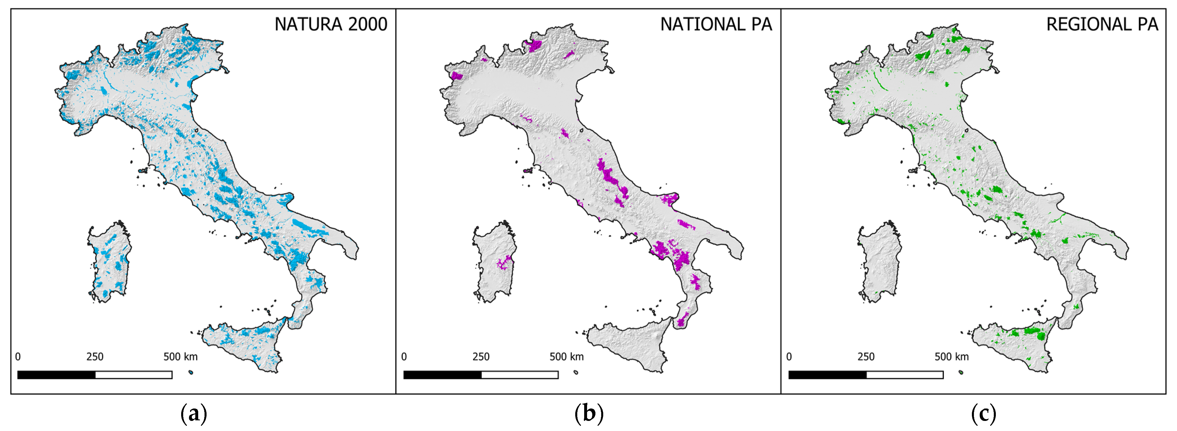
  • EU Natura 2000 sites include the Special Area of Conservation (SAC), the Special Protection Areas (SPA), and the Sites of Community Importance (SCI).
  • National PAs: national parks, state nature reserves, and other national protected areas.
  • Regional PAs: regional parks, regional nature reserves, and other regional protected areas.
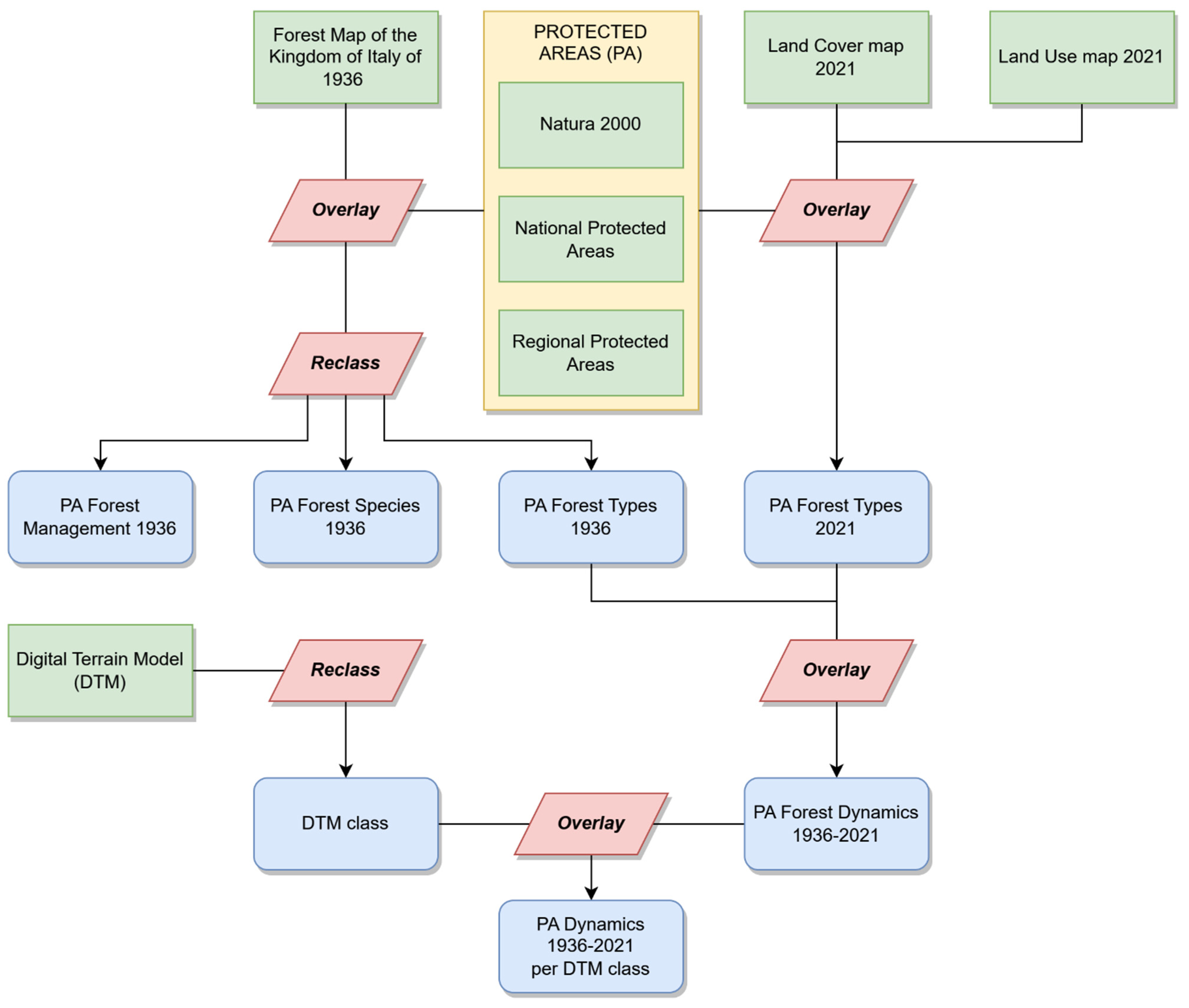
Finally, the spatial elaborations according to altimetry have been based on a 10 m-resolution Digital Terrain Model (DTM) produced by the Italian National Institute of Geophysics and Volcanology (INGV) and downloaded from its website [36].

2.2. Methodology

All the spatial analyses have been performed using QGIS 3.22 with the GRASS plug-in. The methodological workflow is represented in Figure 2.
The first step focused on preparing the 1936 and the 2021 databases to compare them with each other.
The legend of the Forest Map of the Kingdom of Italy of 1936 was reclassified to make it comparable with the most recent database. The original 1936 legend, in fact, included information both on forests and on the management form for broadleaf forests, as it was created according to a wood production perspective. The original legend was organized into categories and subcategories. Forests were first classified according to the physiognomic category and to the main species, and secondly according to the management form (high forest, coppice, coppice with standards). It must be noticed that the original 1936 legend included the “degraded forest” category; this category does not have a clear definition, and no management forms have been associated with this forest type. It was probably used to categorize different forest communities as Mediterranean maquis, areas degraded by fires or overgrazing, or dense shrublands. The original legend has been reclassified (Table 1) according to the forest type to make it comparable with the 2021 forest map: broadleaf forest, coniferous forest, and degraded forest. The information about the management form has instead been used to assess the amount of forest included in PAs that was regularly managed as coppice or coppice with standards in 1936.
For 2021, the two datasets (Land cover map 2021 and Land use map 2021) have been interpolated to obtain a single raster, to reduce the error, and to preserve the information of the different forest types (conifer or broadleaf). In fact, the Land cover map for 2021 contains information about the type of vegetation, but it classifies all the areas with a tree cover greater than 20% as forest, even including orchards and olive groves. The Land use map 2021, instead, is more precise about the spatial delimitation of forest areas, excluding orchards and other land covered with trees, but does not include information about the forest type. Therefore, the overlapping of these two datasets allowed for an accurate and reliable forest map of 2021, both regarding the spatial delimitation and the forest type classification.
Regarding the protected areas, the Natura 2000 sites have been merged to avoid overlapping.
After these preliminary elaborations on base layers, the Forest Map of the Kingdom of Italy of 1936 and the 2021 forest map have been clipped according to the three layers of the three different PA typologies; in addition, different raster layers have been created regarding the forest type, species, and management forms. Overall, 12 separate raster layers have been produced:
  • 1936 forest type (conifer or broadleaf) in EU Natura 2000 sites;
  • 1936 forest type (conifer or broadleaf) in national PAs;
  • 1936 forest type (conifer or broadleaf) in regional PAs;
  • 1936 forest species in EU Natura 2000 sites;
  • 1936 forest species in national PAs;
  • 1936 forest species in regional PAs;
  • 1936 management form for EU Natura 2000 sites;
  • 1936 management form in national PAs;
  • 1936 management form in regional PAs;
  • 2021 forest type (conifer or broadleaf) for EU Natura 2000 sites;
  • 2021 forest type (conifer or broadleaf) in national PAs;
  • 2021 forest type (conifer or broadleaf) in regional Pas.
The second step involved the cross-product between the 1936 and 2021 forest type raster files to obtain the map of forest changes between 1936 and 2021 (for each PA type). The result of this cross product has been reclassified to obtain the following categories:
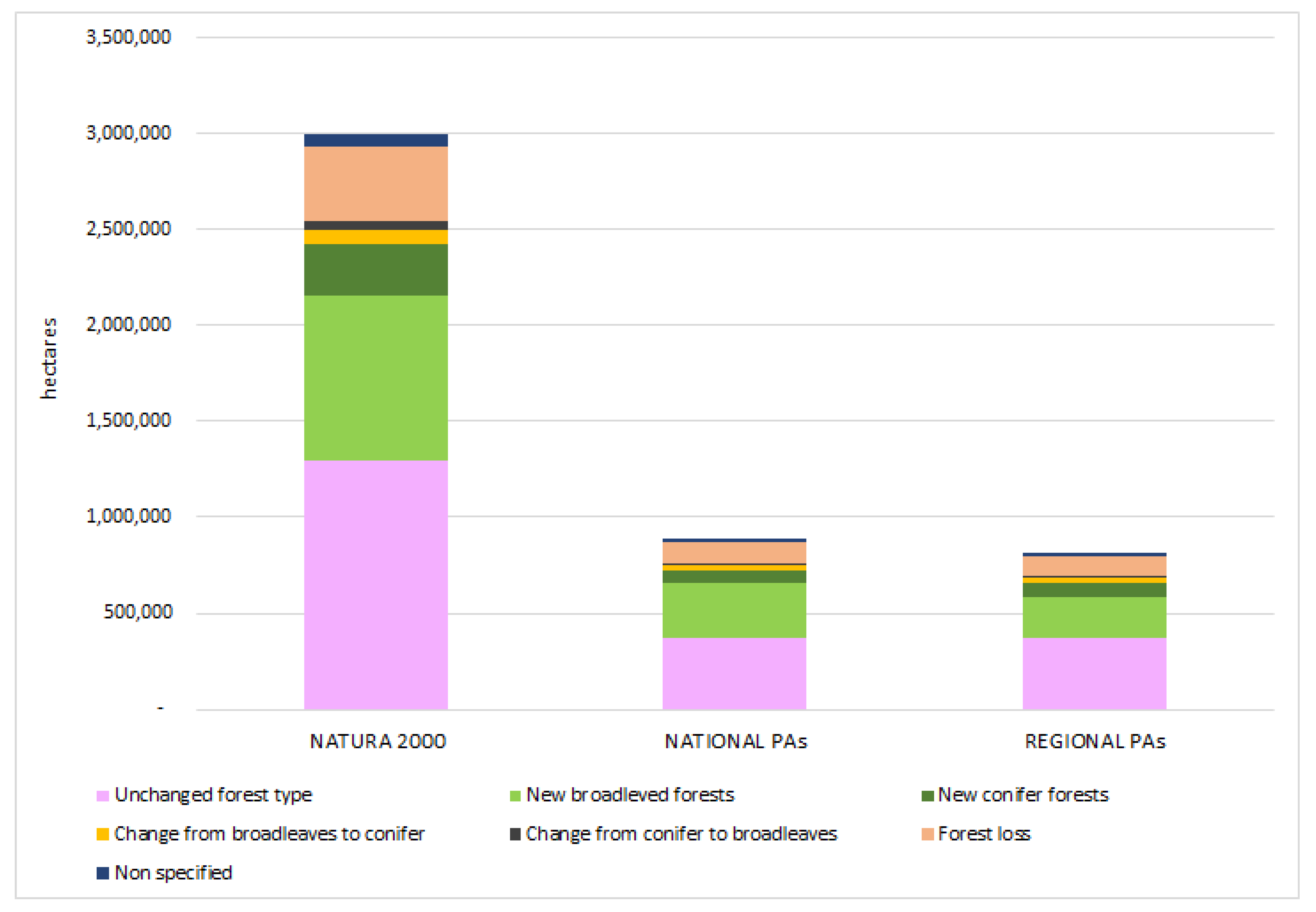
  • Not forest: surface that was not forest in 1936 or 2021.
  • Unchanged: surface covered by the same forest type in both 1936 and 2021.
  • Forest loss: surface covered by forest in 1936 but not in 2021.
  • Change of forest type: surface covered by forest in 1936 and 2021, but the forest types changed:
    From conifer to broadleaf;
    From broadleaf to conifer.
  • New forest: surface not covered by forest in 1936 and covered by forest in 2021:
    New broadleaf forest;
    New conifer forest.
  • Non-specified: surface with a non-specified forest type in 1936 that remains forest in 2021 (the lost non-specified forest surfaces have been included in the “forest loss” category).
The data collected has been summarized in a graph with the percentage of these categories.
The outputs of this process are the following raster files:
  • Forest changes between 1936 and 2021 in EU Natura 2000 sites;
  • Forest changes between 1936 and 2021 in national PAs;
  • Forest changes between 1936 and 2021 in regional PAs.
The third step was related to the intersection of the forest change databases with the altimetry classes. The original 10 m-resolution DTM has been reclassified into variable elevation classes instead of dividing the territory into homogeneous classes with the same altitude to facilitate the analysis of the results. After some attempts, it has been decided that the following variable altitude classes are the most suitable for representing the complex morphology of the territory and the altitude variability within Italian PAs: 0–50 m a.s.l., 50–100 m a.s.l., 100–200 m a.s.l., 200–500 m a.s.l., 500–1000 m a.s.l., 1000–2000 m a.s.l., and above 2000 m a.s.l. The use of a high-resolution DTM (10 m) covering all the national surface allowed to obtain more precise results, especially for the PAs of limited surface, even if it led to the creation of large files and therefore to longer times for processing them with GIS software. The outputs of this step are the following raster files:
  • Distribution of forest changes between 1936 and 2021 per altitude class in EU Natura 2000 sites;
  • Distribution of forest changes between 1936 and 2021 per altitude class in national PAs;
  • Distribution of forest changes between 1936 and 2021 per altitude class in regional PAs.
Some limitations have also been considered during the design of the research and the performing of the different analyses. Studies based on GIS elaborations of different datasets created with different methodologies and referring to different periods must consider possible causes of inaccuracy, in particular if the study foresees the use of historical maps [35,37]. The main limitation is in fact related to the different methodologies, levels of detail, classification, spatial accuracy, sources of information, and tools that have been used to produce these datasets [38,39]. Despite these recognized limitations, the use and comparison of different land use datasets is largely assessed in studies focusing on forests and landscape changes, representing a crucial source for investigating historical forest surface and management as well as for the identification of the main changes and trends.

3. Results

3.1. Terrestrial Protected Areas in Italy

In Italy, the overall surface (without considering overlapping) of inland Natura 2000 sites is equal to 5,834,658 ha, corresponding to 19% of the national surface. In addition, there are 170 different terrestrial national PAs (24 national parks, 144 state nature reserves, and two other national protected areas) for a total surface of about 1,591,445 ha (5%), while inland regional and local PAs are 670 (134 regional parks, 365 regional nature reserves, and 171 other protected areas) for a total surface of about 1,542,068 ha (5%). Without considering overlapping between different PAs (EU, national, or regional), the total inland protected surface in Italy is 6,524,086 ha (22% of the national surface).

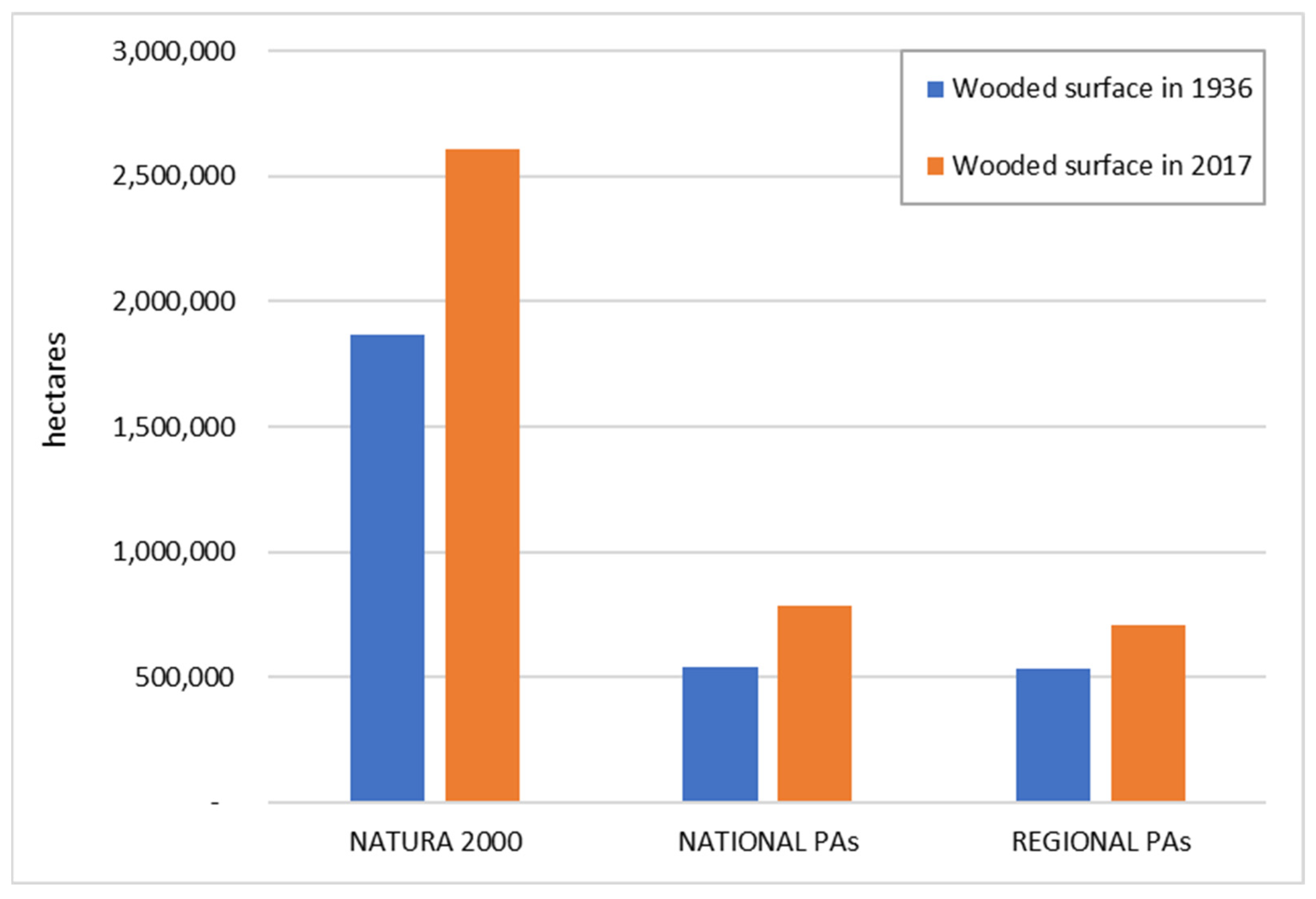
3.2. Forests of 1936 within Current Protected Areas

Considering the actual presence of PAs in Italy, their surface was only partly covered by forest in 1936, ranging from 32% in Natura 2000 sites to 35% in regional PAs (Table 2). The analyses based on the species or on forest types (conifer or broadleaf) do not highlight significant differences due to the different types of PAs. Most of the forests were composed of broadleaf (77%–79%), with beeches representing the most common species in single-species woods, followed by deciduous oaks, even if most of the forests included in current PAs were classified as “other species or mixed woods”. Beech forests were more common among national PAs, where they represented 38% of the forests, while they were less common in regional PAs and in Natura 2000 sites (22% and 24%, respectively); this is due to the fact that national PAs are mainly located in mountainous areas. Chestnuts were also common, especially as they were a key source of food for the people living in mountains and hills. It is interesting to notice that most of these forests were regularly managed in 1936: 44% of the forests in national PAs were classified as coppice, and this percentage increases to 56% if we consider Natura 2000 sites and to 62% if we consider regional PAs.

3.3. Forests of 2021 within Current Protected Areas

According to the elaboration of the data referring to 2021, about half of the PAs are occupied by forests, with little difference according to the type of protected area (Table 3); in Natura 2000 sites, 45% of the total surface is occupied by forests, 46% in regional PAs, and 49% in national PAs. Most of the forests are classified as broadleaf forests, with percentages ranging from 77% in regional PAs to 81% in national PAs. No specific information about the prevalent species of the management forms is reported by these or other recent forest databases.

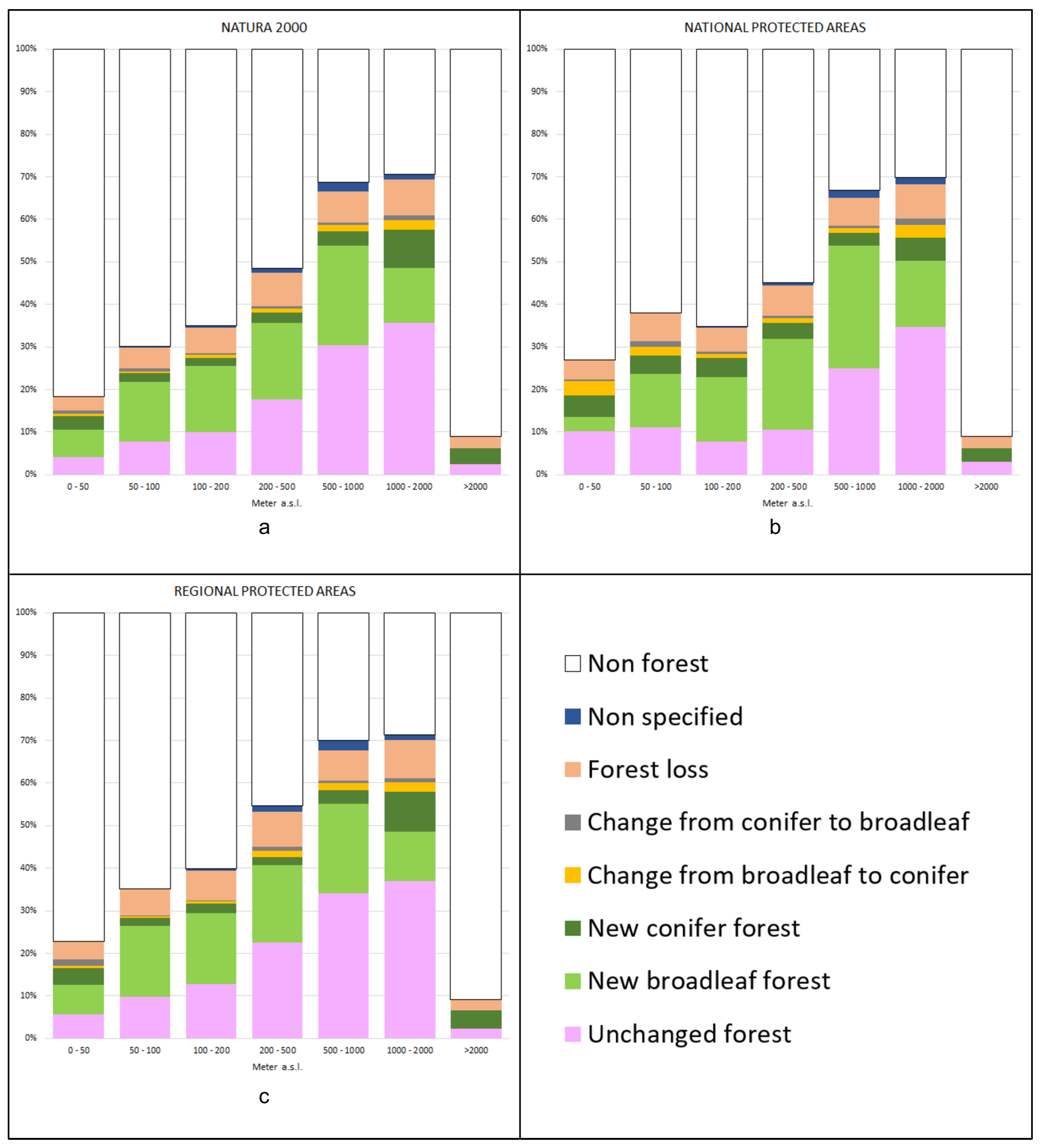
3.4. Forest Changes in the Period 1936–2021 within Protected Areas

The forest surface in current PAs has clearly increased in the last 85 years (Figure 3). This trend is common to all the PAs, despite their type, even if the highest percentage growth is reached in national PAs (+45.2%) and the lower one is in regional PAs (33.1%). Since Natura 2000 sites are the type of PAs with the highest total surface, the yearly growth rate in the period 1936–2021 is the highest and is equal to 8709 ha/year (Table 4).
Beside the increase in total forested surface in the last 85 years, the performed analyses allowed to assess and measure the different forest dynamics in the different types of PAs. Regarding the type of forest responsible for the total increase in forested surface, most of the new forests are composed of broadleaf species (25.6%–28.6% of the forest dynamics), and only a minority of them are new conifer forests (7.5%–9.2% of the forest dynamics) (Figure 4). In all the different types of PAs, the transformation from one type to another is limited in terms of total hectares, while in all the PA types, a significant portion of the surface has been affected by deforestation. Deforestation ranges from 12% of the forest dynamics surface in national PAs to 13.2% in regional PAs. These values are mainly due to the different forest definitions applied by the two forest maps (1936 and 2021); in fact, a visual assessment of these areas using 2021 satellite images showed that the 2021 forest map underestimates the presence of the forest, especially in areas of high maquis that are not considered forests.
The analyses of the forest changes within different types of PAs according to the altimetry allowed us to identify the altitude classes more affected by the growth of new forests. Concerning Natura 2000 sites (Figure 5a), the areas comprised in the range 500–1000 m a.s.l. are the ones more affected by forest spread, as it occurs on 26.8% of their surface, followed by the ones in the range of 1000–2000 m a.s.l. (21.8% of the surface), while the classes with less forest surface growth in percentage are the ones located at altitudes lower than 50 m a.s.l. and above 2000 m a.s.l., where forest cover was already limited. In all the altitude classes, the increase of broadleaf forests is significantly higher if compared to conifer forests, except for the areas located at 1000–2000 m a.s.l., where new conifer forests occupy 8.9% of the total surface of that altitude class, and above 2000 m a.s.l., where almost all the new forests are composed of conifers.
The spread of new forest surfaces in national PAs (Figure 5b) follows the same pattern, with most of them concentrated in the range 500–1000 m a.s.l., where they account for 31.9% of the total surface of this altitudinal class, mainly represented by new broadleaf forests. The same trend occurs with slightly lower intensity between 200 and 500 m a.s.l. (25.1% of the surface of this altitudinal class) and between 1000 and 2000 m a.s.l. (21%). Most new forest surfaces are composed of broadleaf forests, except for the PAs located at altitudes lower than 50 m a.s.l. and above 2000 m a.s.l., where new forests primarily correspond to conifer forests.
Furthermore, in regional PAs (Figure 5c), the spread of new forest surfaces is higher in the altitude class 500–1000 m a.s.l. (24.2% of the total surface of this altitudinal class), but is noteworthy also in the lower classes (50–100 m, 100–200 m, and 200–500 m).

4. Discussion

In some regions of the world, such as Europe, the abandonment of agricultural land is one of the most widespread forms of land use change, affecting a wider surface than urbanization, with this trend occurring with higher intensity in Mediterranean countries [40,41,42]. Several studies demonstrated for different Italian areas that the abandonment of pastures and agricultural surfaces started in the 1950s and led to reforestation processes, especially in rural marginal areas [43,44]. The findings of our study confirm that this trend is also found inside protected areas, as a significant portion of the forests currently included in PAs originated after 1936, probably as a consequence of the abandonment of pastures and agricultural activities. In regional PAs, 40.1% of the current forest cover originated after 1936, and this percentage increased to 43% in Natura 2000 sites and to 44.7% in national PAs. Therefore, only around half of the forest surface included in PAs has the same forest type as in 1936. Similar situations have been reported by Pallotta et al. [45] for national parks in the mountains of Abruzzo, Lazio e Molise regions, where from 1954 on, forests increased their surface area by colonizing abandoned grasslands.
Mountainous regions, in Italy and also in other European countries, are in fact the areas where forests mostly increased the surface as a consequence of the crisis of the traditional livestock sector and of free grazing, which led to pasture abandonment [27]. In the period 1954–2012, Apennine landscape mosaics experienced structural simplification, with grassland-to-forest transition mainly located at higher altitudes and cropland-to-forest transition at lower ones, and with forest expansion occurring more rapidly in the lower part of the Apennine mountains range, as at higher altitudes climate conditions are less favorable due to the reduced vegetative season [46]. Our study confirms this correlation between altimetry and forest surface increase, as the spread of forests is more concentrated between 500 and 1000 m a.s.l.
Other studies reported that forest expansions occurred in different social and environmental contexts, even in periurban and densely populated areas. According to Solano et al. [47], in the Rome metropolitan area, in the period 1936–2010, forest surface increased (from 17.6% to 25.5%), with higher rates in the interior landscape, mainly within protected areas.
The same trend has been found for other national parks in Italy [48], as in the Cinque Terre NP, where reforestation on abandoned dry-stone terraces also led to an increase in slope instability, landslides, and soil erosion [49]. In fact, secondary successions can also cause a decrease in different ecosystem services provided by the presence of a traditional cultural landscape, including hydrogeological protection. According to various studies, land use and land cover change are also the most important drivers of biodiversity loss, also in legally protected areas [50], especially considering that land uses such as grasslands are commonly and erroneously perceived as having “poorer” biodiversity if compared to forests [51].
Our study also proved that in 1936, around half of the forests were classified as coppices, and even if no management information was reported for high stand or conifer forests, it is reasonable to assume that many of them were regularly utilized to obtain timber too. In this regard, it is important to highlight how managed forests have a higher recreational economic value than unmanaged forests; therefore, active management of forests inside PAs, especially those developed after 1936, can also contribute to increasing the attractiveness of PAs among visitors and to preserving a more heterogeneous forest landscape made of different forest communities [52]. Regarding public perception of spontaneous forest regrowth, in fact, this is generally negative in rural areas and more positive in peri-urban landscapes [53]. Similar differences have been reported for Cinque Terre NP and UNESCO sites among people actively involved in the agricultural sector and people living in the same area but engaged in different job sectors [54]. Natural forest regrowth can be perceived and associated with different features, from abandoned territory to recovered land, even if significant differences regarding trade-offs and opportunities seem to be correlated to the local situation [55]. In any case, forest surface expansion in cultural landscapes is almost always perceived as a clear worsening of the local scenario by local inhabitants, thereby affecting the aesthetic dimension [56,57,58]. Finally, unmanaged forests developed because of secondary successions on abandoned pastures or croplands are more subject to different natural hazards [59], especially in Mediterranean environments where biomass accumulation increases the risk of wildfire [60,61,62,63].

5. Conclusions

Considering the findings of our study, is it possible to state that most of the forest surface included in Italian protected areas has a clear cultural origin, being the consequence of the abandonment of pastures and cultivated areas that occurred in the last 85 years. In addition, in the past, most of the forests included in the current protected areas system were regularly managed, often as coppices, creating a landscape mosaic of great heterogeneity made of different land uses and different habitats. These habitats were therefore related to the presence of cultural activities that have shaped the landscape over the centuries, contributing to the high complexity of landscape mosaics and high levels of landscape-scale biodiversity since different management practices lead to the formation of different communities inside the same forest type. Through forest management, it is possible to maintain a specific evolutionary stage of the forest, while natural succession leads the forest to homogenize over time. With the cessation of most of the regular management of these forests and the expansion of forest surfaces through secondary successions, the landscape of protected areas has been affected by a progressive homogenization and by a decrease in the variety of habitats related to the presence of different land uses and different human activities.
Current planning in Italian protected areas should take into consideration that most of the preserved forests are “cultural forests”, and that the application of traditional forest management forms can be crucial for restoring and preserving a more articulated and complex landscape mosaic. A highly diversified forest landscape mosaic could, in fact, favor the creation and conservation of different habitats and microhabitats, which can favor different flora and fauna species.
It is also necessary to consider that even if derived from a natural process of secondary succession, new forest areas also possess traits derived from previous anthropic interventions: the species that colonize the new areas derive in fact from the species present in the surroundings, which in turn derive from a process of selection, if not of implantation, due to the needs of the local populations. Furthermore, the soils that have been colonized by new forests were modified by anthropic activities, as they were previously dedicated to agriculture or grazing. For these reasons, it might be accurate to call them cultural forests or semi-cultural forests, as their actual characteristics are also the consequence of past anthropic activities. Italian forests have always been actively managed by the local population, and only the maintenance of different and sustainable forest management practices can counteract the homogenization of the landscape.

Author Contributions

Conceptualization, A.S.; methodology, A.S. and F.P.; software, F.P.; writing—original draft preparation, A.S. and F.P.; supervision, A.S. and F.P. All authors have read and agreed to the published version of the manuscript.

Funding

This research received no external funding.

Data Availability Statement

The data are available on request.

Conflicts of Interest

The authors declare no conflict of interest.

References

  1. FAO; UNEP. The State of the World’s Forests 2020: Forests, Biodiversity and People; FAO: Rome, Italy, 2020. [Google Scholar]
  2. Trosper, R.L.; Parrotta, J.A. Introduction: The growing importance of traditional forest-related knowledge. In Traditional Forest-Related Knowledge; Springer: Dordrecht, The Netherlands, 2012. [Google Scholar]
  3. Parrotta, J.; Yeo-Chang, Y.; Camacho, L.D. Traditional knowledge for sustainable forest management and provision of ecosystem services. Int. J. Biodivers. Sci. Ecosyst. Serv. Manag. 2016, 12, 1–4. [Google Scholar] [CrossRef]
  4. Parrotta, J.A.; Agnoletti, M. Traditional forest-related knowledge and climate change. In Traditional Forest-Related Knowledge; Springer: Dordrecht, The Netherlands, 2012; pp. 491–533. [Google Scholar]
  5. Joa, B.; Schraml, U. Conservation practiced by private forest owners in Southwest Germany—The role of values, perceptions and local forest knowledge. For. Policy Econ. 2020, 115, 102141. [Google Scholar] [CrossRef]
  6. Hernandez Marentes, M.A.; Venturi, M.; Scaramuzzi, S.; Focacci, M.; Santoro, A. Traditional forest-related knowledge and agrobiodiversity preservation: The case of the chagras in the Indigenous Reserve of Monochoa (Colombia). Biodivers. Conserv. 2022, 31, 2243–2258. [Google Scholar] [CrossRef]
  7. Johnson, E.A.; Miyanishi, K. The boreal forest as a cultural landscape. Ann. N. Y. Acad. Sci. 2012, 1249, 151–165. [Google Scholar] [CrossRef]
  8. Agnoletti, M.; Santoro, A. Cultural values and sustainable forest management: The case of Europe. J. For. Res. 2015, 20, 438–444. [Google Scholar] [CrossRef]
  9. Johann, E. Traditional forest management under the influence of science and industry: The story of the alpine cultural landscapes. For. Ecol. Manag. 2007, 249, 54–62. [Google Scholar] [CrossRef]
  10. Balée, W. Cultural Forests of the Amazon: A Historical Ecology of People and Their Landscapes; University of Alabama Press: Tuscaloosa, AL, USA, 2013. [Google Scholar]
  11. Buchwald, E. A hierarchical terminology for more or less natural forests in relation to sustainable management and biodiversity conservation. In Proceedings of the Third Expert Meeting on Harmonizing Forest-Related Definitions for Use by Various Stakeholders, Rome, Italy, 17–19 January 2005; Food and Agriculture Organization of the United Nations: Rome, Italy, 2005. [Google Scholar]
  12. Agnoletti, M.; Piras, F.; Venturi, M.; Santoro, A. Cultural values and forest dynamics: The Italian forests in the last 150 years. For. Ecol. Manag. 2002, 503, 119655. [Google Scholar] [CrossRef]
  13. Adams, W. Future Nature: A Vision for Conservation; Earthscan: London, UK, 2003. [Google Scholar]
  14. Rotherham, I.D. The call of the wild: Perceptions, history people & ecology in the emerging paradigms of wilding. ECOS 2014, 35, 35–43. [Google Scholar]
  15. FAO. Global Forest Resources Assessment 2020: Main Report; FAO: Rome, Italy, 2020. [Google Scholar]
  16. Kuusela, K. Forest Resources in Europe 1950–1990; Cambridge University Press: Cambridge, UK, 1994; Volume 1. [Google Scholar]
  17. García-Ruiz, J.M.; Lasanta, T.; Nadal-Romero, E.; Lana-Renault, N.; Álvarez-Farizo, B. Rewilding and restoring cultural landscapes in Mediterranean mountains: Opportunities and challenges. Land Use Policy 2020, 99, 104850. [Google Scholar] [CrossRef]
  18. Drenthen, M. Rewilding and the ethics of place. In Routledge Handbook of Rewilding; Routledge: London, UK, 2022; pp. 351–361. [Google Scholar]
  19. Bauer, N.; Wallner, A.; Hunziker, M. The change of European landscapes: Human-nature relationships, public attitudes towards rewilding, and the implications for landscape management in Switzerland. J. Environ. Manag. 2009, 90, 2910–2920. [Google Scholar] [CrossRef]
  20. Schulp, C.J.; Levers, C.; Kuemmerle, T.; Tieskens, K.F.; Verburg, P.H. Mapping and modelling past and future land use change in Europe’s cultural landscapes. Land Use Policy 2019, 80, 332–344. [Google Scholar] [CrossRef]
  21. Piras, F.; Venturi, M.; Corrieri, F.; Santoro, A.; Agnoletti, M. Forest surface changes and cultural values: The forests of Tuscany (Italy) in the last century. Forests 2021, 12, 531. [Google Scholar] [CrossRef]
  22. Axelsson, A.; Ostlund, L. Retrospective gap analysis in a Swedish boreal forest landscape using Historical data. For. Ecol. Manag. 2001, 147, 109–122. [Google Scholar] [CrossRef]
  23. Östlund, L.; Norstedt, G. Preservation of the cultural legacy of the indigenous Sami in northern forest reserves–Present shortcomings and future possibilities. For. Ecol. Manag. 2021, 502, 119726. [Google Scholar] [CrossRef]
  24. Samojlik, T.; Fedotova, A.; Daskiewicz, P.; Rotherham, I.D. Bialowieza Primeval Forest; Nature and Culture in the Nineteenth Century; Springer: Dordrecht, The Netherlands; New York, NY, USA, 2020. [Google Scholar]
  25. Stereńczak, K.; Zapłata, R.; Wójcik, J.; Kraszewski, B.; Mielcarek, M.; Mitelsztedt, K.; Białczak, M.; Krok, G.; Kuberski, Ł.; Markiewicz, A.; et al. ALS-based detection of past human activities in the Białowieża Forest—New evidence of unknown remains of past agricultural systems. Remote. Sens. 2020, 12, 2657. [Google Scholar] [CrossRef]
  26. Sauer, C. The Morphology of Landscape; Publications in Geography; University of California: Los Angeles, CA, USA, 1925; Volume 2, p. 2. [Google Scholar]
  27. MacDonald, D.; Crabtree, J.R.; Wiesinger, G.; Dax, T.; Stamou, N.; Fleury, P.; Lazpita, J.G.; Gibon, A. Agricultural abandonment in mountain areas of Europe: Environmental consequences and policy response. J. Environ. Manag. 2000, 59, 47–69. [Google Scholar] [CrossRef]
  28. Rippa, A. Hunting, rewilding, and multispecies entanglements in the Alps. Ethnos 2021, 1–23. [Google Scholar] [CrossRef]
  29. Conti, G.; Fagarazzi, L. Forest expansion in mountain ecosystems: “Environmentalist’s dream” or societal nightmare. Planum 2005, 11, 1–20. [Google Scholar]
  30. Koninx, F. Ecotourism and rewilding: The case of Swedish Lapland. J. Ecotourism 2019, 18, 332–347. [Google Scholar] [CrossRef]
  31. Otte, A.; Simmering, D.; Wolters, V. Biodiversity at the landscape level: Recent concepts and perspectives for multifunctional land use. Landsc. Ecol. 2007, 22, 639–642. [Google Scholar] [CrossRef]
  32. Noss, R.F. A regional landscape approach to maintain diversity. Bioscience 1983, 33, 700–706. [Google Scholar] [CrossRef]
  33. Wu, J.G.; Hobbs, R. Key issues and research priorities in landscape ecology: An idiosyncratic synthesis. Landsc. Ecol. 2002, 17, 355–365. [Google Scholar] [CrossRef]
  34. Zimmermann, P.; Tasser, E.; Leitinger, G.; Tappeiner, U. Effects of land-use and land-cover pattern on landscape-scale biodiversity in the European Alps. Agric. Ecosyst. Environ. 2010, 139, 13–22. [Google Scholar] [CrossRef]
  35. Ferretti, F.; Sboarina, C.; Tattoni, C.; Vitti, A.; Zatelli, P.; Geri, F.; Pompei, E.; Ciolli, M. The 1936 Italian Kingdom Forest Map reviewed: A dataset for landscape and ecological research. Ann. Silvicultural Res. 2018, 42, 3–19. [Google Scholar]
  36. Tarquini, S.; Isola, I.; Favalli, M.; Battistini, A.; Dotta, G. TINITALY, a Digital Elevation Model of Italy with a 10 Meters Cell Size (Version 1.1); Istituto Nazionale di Geofisica e Vulcanologia (INGV): Roma, Italy, 2023. [CrossRef]
  37. Rumsey, D.; Williams, M. Historical maps in GIS. In Online Journal of the Map and Geography Round Table of the American Library Association. Series B; American Library Association: Chicago, IL, USA, 2002. [Google Scholar]
  38. San-Antonio-Gómez, C.; Velilla, C.; Manzano-Agugliaro, F. Urban and landscape changes through historical maps: The Real Sitio of Aranjuez (1775–2005), a case study. Comput. Environ. Urban Syst. 2014, 44, 47–58. [Google Scholar] [CrossRef]
  39. Ridding, L.E.; Newton, A.C.; Redhead, J.W.; Watson, S.C.; Rowland, C.S.; Bullock, J.M. Modelling historical landscape changes. Landsc. Ecol. 2020, 35, 2695–2712. [Google Scholar] [CrossRef]
  40. van der Zanden, E.H.; Verburg, P.H.; Schulp, C.J.; Verkerk, P.J. Trade-offs of European agricultural abandonment. Land Use Policy 2017, 62, 290–301. [Google Scholar] [CrossRef]
  41. Perpiña Castillo, C.; Coll Aliaga, E.; Lavalle, C.; Martínez Llario, J.C. An assessment and spatial modelling of agricultural land abandonment in Spain (2015–2030). Sustainability 2020, 12, 560. [Google Scholar] [CrossRef]
  42. Rühl, J.; Gristina, L.; La Mantia, T.; Novara, A.; Pasta, S. Afforestation and reforestation: The Sicilian case study. In The Greenhouse Gas Balance of Italy: An Insight on Managed and Natural Terrestrial Ecosystems; Springer: Berlin/Heidelberg, Germany, 2015; pp. 173–184. [Google Scholar]
  43. Garbarino, M.; Morresi, D.; Urbinati, C.; Malandra, F.; Motta, R.; Sibona, E.M.; Vitali, A.; Weisberg, P.J. Contrasting land use legacy effects on forest landscape dynamics in the Italian Alps and the Apennines. Landsc. Ecol. 2020, 35, 2679–2694. [Google Scholar] [CrossRef]
  44. Bracchetti, L.; Carotenuto, L.; Catorci, A. Land-cover changes in a remote area of central Apennines (Italy) and management directions. Landsc. Urban Plan 2012, 104, 157–170. [Google Scholar] [CrossRef]
  45. Pallotta, E.; Boccia, L.; Rossi, C.M.; Ripa, M.N. Forest Dynamic in the Italian Apennines. Appl. Sci. 2022, 12, 2474. [Google Scholar] [CrossRef]
  46. Malandra, F.; Vitali, A.; Urbinati, C.; Weisberg, P.J.; Garbarino, M. Patterns and drivers of forest landscape change in the Apennines range, Italy. Reg. Environ. Chang. 2019, 19, 1973–1985. [Google Scholar] [CrossRef]
  47. Solano, F.; Praticò, S.; Piovesan, G.; Chiarucci, A.; Argentieri, A.; Modica, G. Characterizing historical transformation trajectories of the forest landscape in Rome’s metropolitan area (Italy) for effective planning of sustainability goals. Land Degrad. Dev. 2021, 32, 4708–4726. [Google Scholar] [CrossRef]
  48. Zannini, P.; Frascaroli, F.; Nascimbene, J.; Halley, J.M.; Stara, K.; Cervellini, M.; Di Musciano, M.; De Vigili, F.; Rocchini, D.; Piovesan, G.; et al. Investigating sacred natural sites and protected areas for forest area changes in Italy. Conserv. Sci. Pract. 2022, 4, e12695. [Google Scholar] [CrossRef]
  49. Agnoletti, M.; Errico, A.; Santoro, A.; Dani, A.; Preti, F. Terraced landscapes and hydrogeological risk. Effects of land abandonment in Cinque Terre (Italy) during severe rainfall events. Sustainability 2019, 11, 235. [Google Scholar] [CrossRef]
  50. Pereira, H.M.; Navarro, L.M. Rewilding Abandoned Landscapes in Europe. In Rewilding European Landscapes; Pereira, H.M., Navarro, L.M., Eds.; Springer: Halle, Germany, 2014; ISBN 978-3-319-12038-6/978-3-319-12039-3. [Google Scholar]
  51. Veldman, J.W.; Overbeck, G.E.; Negreiros, D.; Mahy, G.; Le Stradic, S.; Fernandes, G.W.; Durigan, G.; Buisson, E.; Putz, F.E.; Bond, W.J. Where tree planting and forest expansion are bad for biodiversity and ecosystem services. BioScience 2015, 65, 1011–1018. [Google Scholar] [CrossRef]
  52. Alessandro, P.; De Meo, I.; Grilli, G.; Notaro, S. Valuing nature-based recreation in forest areas in Italy: An application of Travel Cost Method (TCM). J. Leis. Res. 2023, 54, 26–45. [Google Scholar] [CrossRef]
  53. Martín-Forés, I.; Magro, S.; Bravo-Oviedo, A.; Alfaro-Sánchez, R.; Espelta, J.M.; Frei, T.; Valdés-Correcher, E.; Fernández-Blanco, C.R.; Winkel, G.; Gerzabek, G.; et al. Spontaneous forest regrowth in South-West Europe: Consequences for nature’s contributions to people. People Nat. 2020, 2, 980–994. [Google Scholar] [CrossRef]
  54. Santoro, A.; Venturi, M.; Agnoletti, M. Landscape perception and public participation for the conservation and valorization of cultural landscapes: The case of the Cinque Terre and Porto Venere UNESCO site. Land 2021, 10, 93. [Google Scholar] [CrossRef]
  55. Frei, T.; Derks, J.; Fernández-Blanco, C.R.; Winkel, G. Narrating abandoned land: Perceptions of natural forest regrowth in Southwestern Europe. Land Use Policy 2020, 99, 105034. [Google Scholar] [CrossRef]
  56. Hunziker, M.; Felber, P.; Gehring, K.; Buchecker, M.; Bauer, N.; Kienast, F. Evaluation of landscape change by different social groups. Mount. Res. Dev. 2008, 28, 140–147. [Google Scholar] [CrossRef]
  57. Ruskule, A.; Nikodemus, O.; Kasparinskis, R.; Bell, S.; Urtane, I. The perception of abandoned farmland by local people and experts: Landscape value and perspectives on future land use. Landsc. Urban Plan 2013, 115, 49–61. [Google Scholar] [CrossRef]
  58. Bieling, C. Perceiving and responding to gradual landscape change at the community level: Insights from a case study on agricultural abandonment in the Black Forest, Germany. Ecol. Soc. 2013, 18, 36. [Google Scholar] [CrossRef]
  59. Soliva, R.; Rønningen, K.; Bella, I.; Bezak, P.; Cooper, T.; Flø, B.E.; Marty, P.; Potter, C. Envisining upland futures: Stakeholder responses to scenarios for Europe’s mountain landscapes. J. Rural. Stud. 2008, 24, 56–71. [Google Scholar] [CrossRef]
  60. Ursino, N.; Romano, N. Wild forest fire regime following land abandonment in the Mediterranean region. Geophys. Res. Lett. 2014, 41, 8359–8368. [Google Scholar] [CrossRef]
  61. Santoro, A.; Venturi, M.; Piras, F.; Fiore, B.; Corrieri, F.; Agnoletti, M. Forest area changes in Cinque Terre National Park in the last 80 years. Consequences on landslides and forest fire risks. Land 2021, 10, 293. [Google Scholar]
  62. Höchtl, F.; Lehringer, S.; Konold, W. “Wilderness”: What it means when it becomes a reality—A case study from the southwestern Alps. Landsc. Urban Plan 2005, 70, 85–95. [Google Scholar] [CrossRef]
  63. van der Zanden, E.H.; Carvalho-Ribeiro, S.M.; Verburg, P.H. Abandonment landscapes: User attitudes, alternative futures and land management in Castro Laboreiro, Portugal. Reg. Environ. Chang. 2018, 18, 1509–1520. [Google Scholar] [CrossRef]
Figure 1. Protected areas in Italy: EU Natura 2000 sites, (a) national (b) and regional (c) protected areas.
Forests 14 00921 g001
Figure 2. Scheme of the methodological approach.
Forests 14 00921 g002
Figure 3. Total forest surface in current PAs from 1936 and 2017.
Forests 14 00921 g003
Figure 4. Forest dynamics in Italian protected areas in the period 1936–2021.
Forests 14 00921 g004
Figure 5. Forest dynamics in the period 1936–2021 according to the different altitude ranges in Natura 2000 sites (a), national protected areas (b), and regional protected areas (c); values are expressed in percentages on the total surface of PAs.
Forests 14 00921 g005
Table 1. The reclassified legend of the 1936 Forest Map of the Kingdom of Italy.
Forest Main SpeciesManagement FormForest Type
BeechCoppiceBroadleaf forest
High forestBroadleaf forest
ChestnutCoppiceBroadleaf forest
High forestBroadleaf forest
Cork oakCoppiceBroadleaf forest
High forestBroadleaf forest
Sessile oakCoppiceBroadleaf forest
Sessile oak and English oakCoppiceBroadleaf forest
High forestBroadleaf forest
Turkey oakCoppiceBroadleaf forest
High forestBroadleaf forest
LarchConiferConifer forest
Mixed with Larch and Norway spruceConiferConifer forest
Norway spruceConiferConifer forest
Silver firConiferConifer forest
Stone pineConiferConifer forest
Other pinesConiferConifer forest
Other species or mixed woodConiferConifer forest
CoppiceBroadleaf forest
High forestBroadleaf forest
UnspecifiedUnspecified
Degraded forestDegradedDegraded
UnclassifiedUnspecifiedUnspecified
Table 2. Forests in 1936 within current protected areas, divided according to forest type, forest management, and species.
NATURA 2000 NATIONAL PAsREGIONAL PAs
ha%ha%ha%
Total surface of PAs5,834,65819%1,591,4455%1,542,0685%
Wooded surface in PAs1,870,26432%538,41134%532,80535%
FOREST TYPE
Broadleaf1,437,93177%427,38079%415,02778%
Conifer335,53818%83,82516%92,00117%
Degraded forest96,7885%27,2065%24,9355%
Not specified70%-0%8420%
MANAGEMENT FORM
High forest383,86621%191,94836%82,61216%
Coppice1,054,06556%235,43244%332,41562%
Conifer335,53818%83,82516%92,00117%
Degraded forest96,7885%27,2065%24,9355%
Not specified70%-0%8420%
MAIN SPECIES
Beech452,33324%204,68038%115,77322%
Chestnut121,8417%21,5004%48,8559%
Cork oak18,0601%10630%82222%
Degraded forest96,7885%27,2065%24,9355%
Larch26,4801%52281%66981%
Mixed with Larch and Norway spruce8400%-0%-0%
Norway spruce36,1162%45411%10,0652%
Other pines71,5144%40,2277%21,2234%
Other species or mixed wood818,14644%169,82432%239,52145%
Sessile oak and English oak181,68210%40,9258%46,8739%
Silver fir10,6381%49611%19780%
Stone pine64160%17390%20130%
Turkey oak29,4102%16,5173%66491%
Table 3. Forests in 2021 within protected areas.
NATURA 2000 NATIONAL PAsREGIONAL PAs
ha % ha%ha%
Total surface of PAs5,834,65819%1,591,4455%1,542,0685%
Wooded surface in PAs2,610,55145%782,03649%709,39546%
FOREST TYPE
Broadleaf2,033,24578%630,57781%548,72077%
Conifer577,30622%151,45919%160,67523%
Table 4. Total forest surface growth in Italian PAs in the period 1936–2021.
NATURA 2000 NATIONAL PAsREGIONAL PAs
Total surface (ha)5,834,6581,591,445 1,542,068
Wooded surface in 1936 (ha)1,870,264538,411 532,805
Wooded surface in 2017 (ha)2,610,551 782,036 709,395
Growth (%)+39.6 +45.2 +33.1
Growth rate (ha/year)8709 2866 2078
Disclaimer/Publisher’s Note: The statements, opinions and data contained in all publications are solely those of the individual author(s) and contributor(s) and not of MDPI and/or the editor(s). MDPI and/or the editor(s) disclaim responsibility for any injury to people or property resulting from any ideas, methods, instructions or products referred to in the content.

