Article

Verification of Structural Strength of Spur Roads Constructed Using a Locally Developed Method for Mountainous Areas: A Case Study in Kochi University Forest, Japan

1
Faculty of Agriculture and Marine Science, Kochi University, Nankoku 783-8502, Japan
2
Tokushima Prefectural Government, Tokushima 770-8570, Japan
3
Okayama-No-Mori-Seibi-Kousha (Okayama Forest Management Public Corporation), Tsuyama 708-0013, Japan
4
Faculty of Life and Environmental Sciences, Shimane University, Matsue 690-8504, Japan
*
Author to whom correspondence should be addressed.
Forests 2023, 14(2), 380; https://doi.org/10.3390/f14020380
Submission received: 19 January 2023 / Revised: 9 February 2023 / Accepted: 10 February 2023 / Published: 13 February 2023

Abstract

:
Owing to steep terrain and complicated geology, constructing spur roads with low cost and sufficient strength is crucial for sustainable forest management in Japan. The Shimanto method was developed for making narrow spur roads robust against collapse around the 2000s in the Shimanto geology belt area, where the strata were slanted because of an accretion wedge. Kochi University Forest adopted this method and constructed some routes of spur roads in the 2010s. In the present study, we assessed the performance of this method in terms of the roadbed strength and bearing capacity. Two routes were selected, namely Sites 1 and 2, constructed in 2013–2016 and 2019–2021, and tested in 2017 and 2021, respectively. The roadbed strength was measured up to a depth of 100 cm using a handy dynamic cone penetrometer with a rammer of 5 kg. The results showed that the roadbed strength of the embankment side was weaker than that of the cut slope side, although the method was supposed to compact the roadbeds equally over the road width. However, most of the roadbeds had sufficient strength; the younger ones tended to have lower strength than the older ones, and the same tendency was observed for the bearing capacity. It was suggested that the soil under the road width should be excavated more widely toward the cut slope side before compaction.

1. Introduction

The forested land in Japan occupies an area of 25 million ha, which is 68% of the land, and most of it is located in mountainous areas: i.e., 24.5% on less than 15° of slope, 39.1% on 15–30°, 13.5% on 30–35°, and 22.8% on more than 35° [1]. The geology features of the Japanese islands are complicated and fragile because the islands are on the edge of the Eurasian tectonic plate, under which the Pacific and the Philippines tectonic plates move gradually downward, creating an accretionary wedge [2,3,4]. The Japan Forestry Agency recommends the following classification for road networks in the forested area. One classification is forest roads with widths of 3.0–5.0 m and, if necessary, retaining structures, such as concrete walls. Standard-sized log trucks (10-t trucks) transport logs on forest roads, which also witness public use. The other classification is spur roads or “forest operation roads” with a road width of around 3.0 m for logging operations; log transportation is achieved by smaller-sized log trucks [5,6,7,8]. This is because the low standards of spur roads, such as narrower road width, higher allowable gradient, and smaller curve radius, are suitable for steep and complicated terrain. Most of the forest roads in Japan allow public traffic and, if necessary, are paved while this is not the case in other countries [3,9,10,11,12]. The construction of road networks in forested areas in Japan has shifted from forest roads to spur roads. In 2012, the total lengths of forest roads and spur roads were 19 × 104 km and 12 × 104 km, respectively. In 2020, they were 20 × 104 km and 20 × 104 km, respectively, equivalent to 8.0 m/ha and 8.0 m/ha for forested areas in Japan [13,14]. Therefore, constructing spur roads with low cost and sufficient strength is crucial for sustainable forest management in Japan. Different terms are used for such roads in Japan, i.e., spur road, strip road, forest operation road, forestry operation road, operation road, etc. Hereafter, the term spur road is used in this paper.
Among the various forest practitioners who have developed spur road construction methods for their local properties of the terrain, geology, soil, and forest, Mr. Keizabrou Ohashi, or Oohashi, is the most famous practitioner, whose contribution includes his method of spur road construction and forest management [3,4,15,16,17,18,19]. The essence of his method, termed the Ohashi-type spur road construction method, is as follows: a minimum road width of around 2.0 m for small-sized trucks, 3-t to 5-t class excavators, and 2-t trucks; detailed route selection against collapse concerning terrain, geology, soil type, forest type, etc.; and use of small, round wood material as the retaining material for the fill slope toe and road shoulder [3,4,15,16,17,18,19]. He developed the method in the late 20th century, mainly for the Chichbu geology belt areas combined with decomposed granite areas. The Chichibu belt collapsed, and once it was deposited below sea level, the geologic stratum was not formed and the soil is fine-grained [3]. Owing to fine-grained soils, large landslides with long runouts can result from heavy precipitation [3]. Because fine-grained soils limit the forest road cut slope height and the ability to construct fill slopes [3], the Ohashi method often employs retaining materials for fill slopes.
The method witnessed widespread use in Japan around the 1990s and 2000s, with some modifications to fit the geology and soil of other areas [20,21]. One such variant is the Shimanto spur road construction method developed around the 2000s by a municipal officer of the forestry section in order to make narrow spur roads robust against collapse, even in steep terrain. The Shimanto belt is relatively young and exhibits typical features of accretionary wedges composed of sedimentary rocks [3]. The slopes facing the north or the Japan Sea are generally dip slopes, and those facing the south or the Pacific Ocean are opposite slopes [3]. There are numerous circular slips and deep-seated landslides on the north-facing slopes, and it is risky to construct roads on the dip slopes [3]. For the inclined stratum in the Shimanto belt, which is composed of sedimentary rocks, deep excavation has been conducted for preparing the structural foundation of the road [4]. After deep excavation to ensure the depth required for the road width, ~30-cm-thick blocks of compacted subsoil were piled up [4]. This method is suitable for gravelly soil, which is the main soil type in the Shimanto belt, while a small portion of clay serves as the bondage medium [4]. The surface soil of the natural slope was maintained during construction and used for the surface of the filling slope to provide an early green surface because it contained buried seeds [4]. In some cases, stumps are placed at the fill slope toes with thick roots embedded under the embankment [6]. The road width is limited to 2.5 m considering the usage of 3 t–5 t class excavators and mini-forwarders [22]. A mini-forwarder is a popular machine for small-scale forestry in Japan. It is propelled by rubber tracks and equipped with a winch with a typical loading capacity of 500–1000 kg [23].
Including the co-related principals of these methods, a training manual [24] was compiled by forest engineers in 2010 for on-the-job training of spur road construction operators in government-aided training programs. The book introduces various local methods developed to fit the geological and terrain features of the area. Umeda et al. [21] pointed out that the designated strength of the roadbed cannot always be obtained in certain areas if a method developed for another area is adopted unless the operator completely understands the concept of the method.
Regarding the proper compaction of roadbed construction, Sawaguchi et al. [25] found that the maximum compaction strength can be obtained by less than 10 round trips of an excavator when it is used as a compaction device. Although more retaining walls are required for forest roads, which have higher design standards than spur roads, on steep terrain [26], the following problem has recently arisen: many sections of improperly constructed spur roads on steep slopes have collapsed one or two years after construction [27]. This problem should be taken into account in construction supervision. Furthermore, companies involved in such unsustainable forest management should be punished by law. Concerning the age-related change effect of road bed strength and bearing capacity, Umeda et al. [21] reported that in areas with low compaction ability soils, there is a spur road construction method that requires three years for completion. This method seems to effectively utilize the age-related change effect of the road strength.
Kochi University Forest adopted the Shimanto method and constructed some routes of spur roads in the 2010s. The forest is in the same prefecture for which the method was developed but in a different geology belt. The present study assesses the performance of the method in terms of the roadbed strength and bearing capacity. We verify the hypothesis that the spur road construction method was properly used to achieve sufficient mechanical strength.

2. Materials and Methods

2.1. Study Site

2.1.1. Location

The study was carried out at two sites in Kochi University Forest, which is located at the northwest boundary of Kami city, Kochi prefecture, Japan (133°36′32.0″ E, 33°42′12.8″ N). It has an area of 124 ha and is composed of eight compartments, which are divided into two blocks: the west and the east blocks (Figure 1). The altitude ranges from 660–1045 m. Coniferous planted forests and natural broad-leaved forests account for 60% and 40% of the vegetation, respectively, which is dominated by Cryptomeria japonica and Chamaecyparis obtusa, and Quercus acuta and Q. serrata, respectively [28]. All the forest roads have a width of 3.0 m, including shoulders, and are unpaved. The spur roads were constructed for forest management and logging operation performed by an 8-t class excavator-based machine (CAT 308D CR) and a 3-t class forwarder (IWAFUJI U3) [29]. The average annual precipitations from 2013 to 2021 at the two nearby meteorological stations, Motoyama town (6100 m to NNW) and Shigeto in Kami city (7900 m to ESE), were 3096 ± STD 637 mm and 3778 ± STD 757 mm, respectively [30].
Two routes were selected for the study: Sites 1 and 2. Site 1 was constructed in FY (fiscal year) 2013–2016 and Site 2 was constructed in FY 2019–2021. Field investigations of Sites 1 and 2 were carried out in 2017 and 2021, respectively. The coordinates of the routes were surveyed using a survey compass with a transit telescope for Site 1 and using a single band GNSS receiver [31] for Site 2.
The entire Kochi University Forest is in the Chichibu geology belt, which consists of an accretionary wedge sedimented from the Carboniferous period to the Jurassic period and is located north, adjacent to the Shimanto geology belt. The detailed geological features are as follows: geological period, Mesozoic–Early Cretaceous–Albian period to Cenozoic–Paleogene–Oligocene–Selandian period; lithology and muddy millstone or metamorphic chert; metamorphism, high P/T wide-area metamorphic rocks, and green mudstone belt [32]. Although many areas are prone to landslides in the Sanbagawa geology belt in Kochi prefecture, which is north adjacent to the Chichibu belt, there are few such areas in both Chichibu and Shimanto geology belts in Kochi prefecture [33]. From the terrain analysis of Yamasaki et al. [34], the average slope gradient is 25–30°, the average height difference within a 500-m circle is 300–400 m, and the contour-round-about factor is moderate for the Kochi University Forest area, resulting in moderate to highly difficult terrain within the Kochi prefecture [34].

2.1.2. Spur Road Construction Method

The spur roads were constructed by three university forest officers using an 8-t class excavator (CAT 308D CR; bucket capacity, 0.28 m3). They had 24, 8, and 6 years of experience at the time of Site 1 spur road construction in 2013. They learned the Shimanto method in some training courses held outside the university and then commenced spur road construction within the university forest on their own around the 2010s.
Figure 2 shows the spur road construction in Kochi University Forest using the Shimanto method. The soil is dug over once with additional depth, then compacted with 20–30-cm-thick layers. An example of the cross-section of the middle-grade slope in Figure 2a is 20° of natural ground. On a steeper natural ground slope (Figure 2b, e.g., 30°), the embankment volume and fill slope length tend to be larger. In such cases, the center line of the spur road is shifted to the uphill side in order to decrease the embankment volume (Figure 2c). The cut slope can be constructed as vertical if its maximum height is less than the limit height of 1.4 m.
Figure 3 shows a practical example of spur road construction in Kochi University Forest during a training course held for university forest officers of other universities in 2012. The excavator dug over the soil for extra depth (Figure 3a). Then, the loose soil was mixed using the bucket, spread over the designated road width (Figure 3b), and compacted by the crawler (Figure 3c). The compaction was carried out for a few layers with a thickness of 20–30 cm each up to the level of the existing road height (Figure 3d).

2.2. Field Survey

2.2.1. Measurement of Roadbed Strength

The roadbed soil strength was tested using a simple dynamic cone penetrometer. There are some types of dynamic cone penetrometers for in situ soil strength measurement in Japan [35], varying in terms of the cone size, hammer mass, and height of a single strike with a hammer. Using a dynamic cone penetrometer, the strength of the soil is expressed as the number of hammer strikes required to penetrate a certain depth of the soil. Umeda et al. [36] standardized the strength values of three penetrometers. Yoshinaga et al. [37] concluded that the in situ density of underground soil can be estimated with the measured strength of a simple dynamic cone penetrometer called the Doken-type penetrometer. Gotou et al. [38] verified the roadbed strength of spur roads and forest roads using a Doken-type simple dynamic cone penetrometer. In the present study, a Doken-type simple dynamic cone penetrometer was used for the measurement of the roadbed strength. The Doken-type penetrometer was developed for in situ measurement on steep slopes with a lighter hammer (5 kg) for convenience rather than the other types [39]. Its measuring procedure has been standardized by the Japan Geotechnical Society, Committee for Standard of Geotechnical Survey, (Japanese Industrial Standards)-1433-2012 [39].
Figure 4 shows the standardized design of the Doken-type dynamic penetrometer (Figure 4a) [39]. The soil strength is measured by striking the hammer at a height of 500 mm (Figure 4b,c) with the road kept vertical. By measuring the penetration depth of each strike or a few strikes, the penetrated depth is converted into an Nd (or Nc) value, which represents the number of strikes required for a penetration depth of 10 cm.
The Nd value is defined as follows:
Nd = 10 (Nh),
where Δh is the penetrating depth of N strikes. In general, Δh is 10 cm; however, for softer soil, Δh was set to one strike. and for harder soil, Δh was set to less than 10 cm. The maximum penetrating depth was set to 100 cm because some research reports have pointed out that the friction of the rod cannot be ignored when the penetrating depth exceeds 100 cm [38,39,40]. In some cases, the Nd value was too large, implying that there was a large rock just under the penetrating point. In such cases, we moved the penetrating point 20–0 cm apart from the original point.
Thresholds of the Nd values were determined for judging the strength requirements as follows. Okimura and Tanaka [41] predicted the potential sliding layer depth in forested areas of sandy soil caused by heavy rain as N10 < 12. The N10 value is measured using a handy dynamic cone penetrometer termed the Kobe University type, which provides nearly the same value as the Doken-type penetrometer. Sugiyama et al. [42] reported that the average Nd value of a collapsed railway embankment was 5.4. Ogawa [43] studied the relationship between slope surface failure and water content variation on the forested slope and found that most of the sliding depth was 0.5–1.5 m, of which the Nd values ranged from 5–10. Hiramatsu and Bitoh [44] analyzed a landslide area on the Chichibu geology belt in Yusuhara town, Kochi prefecture, and proposed a threshold Nd value of 9 to estimate the slippage depth of the soil layer. Koyama [45] conducted a series of field investigations on spur roads using a simpler dynamic penetrometer called the Tottori FK-type penetrometer and found that cracks appeared at the road shoulders if the Nd equivalent values were less than 1.4 with a penetrating depth of up to 25 cm. For these preceding achievements, we set the following three thresholds: Nd = 1.4 as “very weak” for clacks on shoulders, Nd = 5.4 as “weak” for the collapse of the embankment, and Nd = 10.0 as “moderate” for natural slope failure.

2.2.2. Measurement of Bearing Capacity

The California bearing ratio (CBR) is a widely used parameter for assessing the bearing capacity of a road subsurface. While proper CBR values are obtained by testing standardized sample soils using appropriate instruments in a laboratory, in situ CBR values are obtained using a purpose-built instrument. Therefore, although the CBR value was originally for the construction of public roads, it is often employed for assessing the bearing capacity of unpaved forest roads and spur roads using in situ CBR testers [46,47,48,49].
Kobayashi and Fukuda [46] measured in situ CBR values of spur roads using a sphere-shaped rammer type in situ CBR tester and obtained the average value of 18.9%. Kobayashi et al. [47] investigated two spur road routes constructed using the Ohashi method with an in situ CBR tester called CASPFOL, and obtained average values of 14.7% and 23.4%. Suzuki et al. [48] evaluated the total strength of a spur road constructed using the Shimanto method in a volcanic ash soil area. For the bearing ratio, they used a CASPFOL tester and obtained in situ CBR values of 2.5–9.8% for ruts on the cut slope sides and 8.0–12.5% for ruts on the fill slope sides. Sawaguchi et al. [49] investigated the age change of the bearing capacity for spur roads in Neogene period gravelly soils for the Tohoku area, northern Japan, using a CASPFOL tester. They found that the CBR values increased from 1.4% to 4.0% at the shoulder, from 1.7 to 5.6% at the center, and from 2.7 to 7.8% at the ruts over 10 years, even if there was nearly no traffic during the gap years [49].
In the present study, we used an in situ CBR tester called CASPFOL (Figure 5a) [50,51]. The soil strength is measured by striking the rummer at a height of 500 mm with the road kept vertical through the built-in acceleration meter (Figure 5b,c). The acceleration of the rummer is measured with the instrument when the rummer falls and strikes the soil. The standard measuring method requires five measurements around a designated point with a radius of 20 cm (Figure 5d).

2.2.3. Soil Property

The grain size distribution has significant effects on soil properties, especially mechanical features, such as compatibility [21]. Soil samples were obtained from a cut slope at two points each for the two sites. The samples were tested for grain size analysis by following the procedure of JIS-A-1202 [52]. Soil property as engineering materials is classified as one of 24 engineering soil types through a standard classification system of the Japanese Geotechnical Society using the parameters derived by the grain size distribution and accompanying tests for the grain size analysis procedures. An additional property, i.e., wideness of size distribution, is assessed using two parameters, the uniformity coefficient Uc and coefficient of curvature Uc, which are defined as follows:
Uc = D60/D10, and
Uc= (D30)2/(D10 × D60),
where D10, D30, and D60 are the grain sizes of the accumulated grain mass percentages of 10%, 30%, and 60%, respectively [52]. If Uc ≥ 10 and 1 < Uc < 3, then the soil is supposed to have wide grain size distribution, which means that it is suitable for compaction [52].

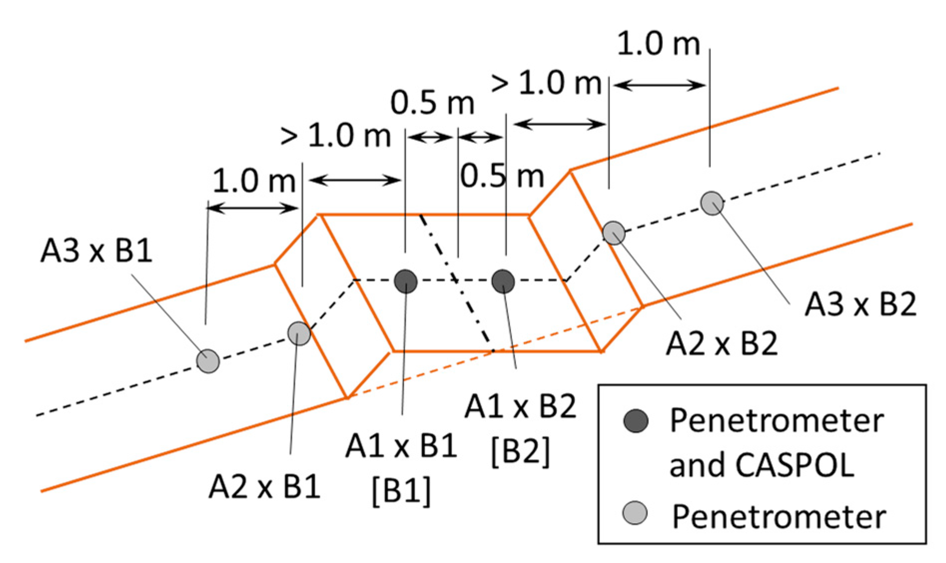
2.2.4. Experimental Design and Analysis

The first series of the investigation was conducted for Site 1 for the measurement of the roadbed strength. To check the equality of the compacted roadbed soil strength around the road width, Factor A was set as a relative position within the road width (Figure 6) with five levels: A1, downhill side apart from the shoulder at least 30 cm; A2, rut of downhill side; A3, center; A4, rut of uphill side; and A5, uphill side apart from the toe of the cut slope at least 30 cm. Factor B was set to the fiscal year of construction in order to check the age-related change in the strength. The spur road of Site 2 was constructed from 2013 to 2016. Because the constructed length of FY 2013 was nearly twice that of the other years, the FY 2013 constructed section was separated at its mid-point into two sections. Therefore, the levels of Factor B are B1, FY2013-1; B2, FY2013-2; B3, FY2014; B4, FY2015; and B5, FY2016. The spur roads were constructed from fall to winter, and Site 1 was investigated in the winter of FY 2017. Hence, the number of years elapsed were 4.2, 4, 3, 2, and 1 for B1, B2, B3, B4, and B5, respectively. It should be noted that the number of years elapsed could not be treated as the effect of time on each road segment in a precise sense. However, in the analysis, it was assumed that the number of years elapsed had a meaning of elapsed time by assuming that each road segment has a homogeneous property. Nevertheless, the effect of the number of years elapsed should be carefully evaluated in this regard.
The number of repetitions of the measurement was set to five so that the distance between every two points would be the same. However, because of the slightly shorter section length of A3, the number of repetitions of A3 was four. Therefore, 24 points were investigated for Site 1 in total.
The obtained data were analyzed by two-way ANOVA [53,54]. The dependent variable was the Nd value up to a depth of 100 cm average weighted by Δh. Two independent variables were Factors A and B. However, in some points, the soil was too hard to reach a depth of 100 cm. When Nd exceeded 50 or more, the penetration was stopped, and the Nd value was averaged up to the maximum depth. One dummy data was added to the A3 level as the mean of four observations so that the number of repetitions is equal to the other levels of A, i.e., five. In the ANOVA table, the degree of freedom was adjusted for Factor A and the error concerning the dummy observations [53].
The second series of the investigation was carried out in Site 2 for the roadbed strength and bearing capacity. As for the roadbed strength, to compare the strength difference between natural soil and compacted soil as well as that between the downhill side and the uphill side, Factor A was set to the distance from the road center and the Factor B direction (Figure 7). The levels of Factor A were as follows: A1, 0.5 m from the center; A2, 1.5 m from the center; and A3, 2.5 m from the center. The points of A1 were nearly on the ruts. The distance between A1 and A2 was, in some cases, more than 1.0 m so that A2 was not on the fill slope. The distance between A2 and A3 was 1.0 m. The factor levels are B1, downhill side, and B2, uphill side.
Factor C was set to the fiscal year of construction. The Site 2 spur road was constructed in 2019, 2020, and 2021. The section distance of 2021 was nearly twice that of the others. Therefore, section FY2021 was separated into two sections at the mid-point. To check the strength difference between the upper and lower parts, Factor D was set to the penetrating depth, i.e., the level D1 was 0–50 cm, and D2 was 50–100 cm. The Nd values were averaged for 0–50 cm and 50–100 cm, respectively. The number of repetitions was two. In Site 2, two points each were investigated at each section of Factor A, at a mid-point of the section and separated by 2 m, because the section length was not as long as that of Site 1. The total number of roadbed strength measurement points was 3 × 2 × 4 × 2 × 2 = 96. The obtained data were analyzed via four-way ANVOVA [53,54]. The dependent variable was the Nd value averaged weighted by Δh. Four independent variables were Factors A, B, C and D.
As for the bearing capacity, in situ CBR measurement, three factors were set. The first two factors, Factors B and C, were set to be the same as those of the roadbed strength. The third factor, Factor R, was set to repetition, having two levels of R1 and R2. Although repetition was not treated as a factor in general, it was included to check for the homogeneity of the measurement. The total number of in situ CBR measurement data was 2 × 4 × 2 × 5 = 80 because five measurements each were required for the standard measurement of the in situ CBR tester. The obtained data were analyzed via three-way ANVOVA [53,54]. The dependent variable was the in situ value. The three independent variables were Factors B, C, and R.
The multi-way ANOVA was analyzed with SAS software using the super-computing service of the Institute for Information Management and Communication, Kyoto University. The two-way ANOVA and the following Tukey test for multiple comparisons [54] were carried out using Microsoft Excel software.

2.2.5. Date of Investigation

The investigation of Site 1 was carried out from November 2017 to January 2018. Surveying of the spur road route and road section measurement using a surveying pole with a precision of 0.1 m were conducted simultaneously.
The investigation of Site 2 was carried out from November 2021 to January 2022. The surveying of the spur road route and road section measurement with a surveying pole with 0.1 m precision were conducted simultaneously.
The soil samples were collected at the sections FY2013 and FY2015 of Site 1, the boundary of sections FY2019 and FY2020 (FY2019–2020), and the first half of FY2021 of Site 2. The FY2015 and the FY2019–2020 samples were collected in December 2020 and analyzed from December 2020 to February 2021. The FY2013 and FY2021 samples were collected in December 2021 and analyzed from December 2021 to January 2022.

3. Results and Discussion

3.1. Overview of the Sites

The total spur road lengths of the sites were 626 and 250 m for Sites 1 and 2, respectively (Table 1 and Table 2). The route of Site 1 had a steep gradient in the section of FY2015, whereas the other sections were nearly flat or had a gentle gradient. In Site 2, the route extended upward; hence, its gradient was relatively high. The average road widths were nearly the same for both sites while the Site 1 route was slightly wider (3.0 m) than the Site 2 route (2.8 m).
The slope gradients of adjacent natural ground were estimated by the connecting fill slope toes and top ends of cut slopes. The average slope gradients of the adjacent natural ground were 26.0 ± STD 6.5° for Site 1 and 21.7 ± STD 2.6° for Site 2. Such a steep natural ground slope of Site 1 resulted in a higher cut slope height (1.3 ± STD 0.4 m) compared to that of Site 2 (0.9 ± STD 0.3 m). This implies that the excavation volume as well as the dig over depth of Site 1 would be larger than those of Site 2 (Figure 2).

3.2. Soil Property

Figure 8 shows the grain size distributions of the obtained soil samples as a result of grain size analysis. All the samples were classified as GFS, fine-grained sandy gravel, of which the mechanical feature is classified as suitable for compaction [52]. Two samples, i.e., Site 1 FY2013 and Site 2 FY2021, were additionally classified to have a wide distribution, the uniformity coefficient of which is Uc ≥ 10, and the coefficient of curvature Uc is between 1 and 3.
The result of the grain size analysis indicated that the soil of both sites has a good property for compaction. It also can be said that there was no major difference between the soil properties of Site 1 and Site 2.

3.3. Site 1: Measurement of Roadbed Strength

The result of the two-way ANOVA on the Nd values in Site 1 indicated that two factors were significant, whereas their interaction was not: A, relative position within the road width, and B, fiscal year of construction (Table 3). In other words, the population means of all the levels were not the same in Factors A and B, and there was no interaction effect in the combination of Factor A levels and Factor B levels.
From a brief inspection of the multiple comparison analysis of Factor A levels (Figure 9), it can be concluded that the roadbed soil strength was not even over the road width. In other words, it was stronger in the cut bunks and weaker in the fill bunks. Thus, the main objective of the Shimanto method was not achieved in the investigated spur road.
As for the effect of Factor B, level B3 (FY2014) had significantly greater Nd values than the other levels (Figure 10). From a visual inspection of the site, a possible reason would be that hard rock materials were more distributed in the FY2014 section than the others. The age-related change, such that older roadbeds gained a larger strength [48,49], is not observed in Figure 10.
Figure 11 shows all the observations of the Nd values in Site 1 accompanied with three thresholds: 1.4, 5.4, and 10.0. While no observation was lower than Nd = 1.4, 15 observations in B4 (FY2015) and B5 (FY2016) and 4 observations in B1 and B2 (FY2013) were lower than Nd = 5.4. In Figure 10, where the values were averaged, the age-related change was not clear. However, the lower limits of the values seem to have a tendency of age-related change and are hence lower for younger ages in Figure 11.

3.4. Site 2

3.4.1. Measurement of Roadbed Strength

In the ANOVA table for the Nd values in Site 2, all the single factors and a few interactions were significant (Table 4). The insignificant interactions were pooled into the error.
As for Factor A (relative position in the road width), A1 (0.5 m from center, 14.4 ± SE (Standard Error) 4.4) was significantly greater than the others (A2, 1.5 m from center, 7.5 ± SE 1.2; A3, 2.5 m from center, 7.4 ± SE 1.3; Tukey test, p < 0.05, n = 32), implying that the soil strength increased from natural 7.4–7.5 to compacted 14.4. The effect of Factor B should be evaluated as the interaction A × B. The average Nd values of A1 × B2, the rut of the uphill side (21.1 ± SE 8.5), were significantly greater than the downhill side (7.6 ± SE 1.0), which was not significantly different from the other remaining interactions (Tukey test, p < 0.05, n = 16). The tendency is the same as that of Site 1 (Figure 9). Note that these Nd values were averaged through a depth of 0–100 cm (D1: 0–50 cm and D2: 50–100 cm). The average Nd values of D2 (15.5 ± SE 3.0) were significantly greater than those of D1 (4.1 ± SE 0.4; p < 0.01, n = 48). As for Factor C, the fiscal year of construction, the level C2 (FY2020, one year after construction, 17.2 ± SE 5.8) was significantly greater than the other levels (C1: FY2019, two years after construction, 6.6 ± SE 1.5; C3: FY2021-1, 0.5 year after construction, 8.4 ± SE 1.3; C4: FY2021-2, 0.5 year after construction, 7.0 ± SE 1.1; Tukey test, p < 0.05, n = 24).
The effect of Factor C can be more clearly observed as interactions between other factors. Figure 12 shows the interaction of Factors A and C. The average Nd values of the combined levels of A1 × C2 were significantly greater than the others, implying a possibility that there were harder subsoils or rocks under the investigated section of C2.
Figure 13 shows the interaction of Factors B, C, and D. From the figure, it can be observed that the average Nd values of the combined levels B1 × C2 × D2 were significantly greater than the others, also implying a possibility that there were harder subsoils or rocks under the rut of the uphill side at a depth of 50–100 cm on the investigated section of C2.
To provide an overview of all the aforementioned observations in Site 2, Figure 14 shows the all-observation average on Factor D, i.e., depth 0–100 cm for comparison with Figure 11 of Site 1. In the figure, the observations on the spur road are marked with filled circles, whereas those on natural ground are marked with open circles. From the figure, the Nd values on the spur road (closed circles) have a tendency of age-related change, except for C1 (FY2019). The Nd values on the natural ground (open circles) have a large variation, which probably reflects various situations of the natural ground.
Compared with the threshold values for C1 (FY2019) and C4 (FY2021-2) × R2, the Nd values on the spur road were lower than Nd = 5.4. Thus, the compaction of the roadbed material soils, especially for FY2019, would have been insufficient to make the excavated soil sufficiently strong.

3.4.2. Measurement of Bearing Capacity

The result of the three-way ANOVA on the in situ CBR values in Site 2 is summarized in Table 5. Although Factor R was not significant, it was not pooled into the error because the interaction B × C × R, which includes Factor R, was significant [53].
As for Factor B (downhill side or uphill side), B2 (uphill side, 16.5 ± SE 0.7%) was significantly greater than B1 (downhill side, 12.5 ± SE 0.7%; p < 0.01, n = 40), implying that the compaction of the road surface soil was better performed in the uphill side than in the downhill side. As for Factor C, the average in situ CBR values of C1 (FY2019, 17.1 ± SE 1.1) and C2 (FY2020, 16.6 ± SE 0.8) were significantly greater than those of C3 (FY2021-1, 12.5 ± SE 1.0) and C4 (FY2021-2, 12.0 ± SE 1.1; Tukey test, p < 0.01, n = 20). The tendency could be regarded as age-related change, i.e., natural compaction [49,50]. The effect of interaction among Factors B, C, and R is shown in Figure 15. In the combined levels of B1 × C1 × R2 and B2 × C4 × R2, the average values seem to be larger than the combined effects of Factors B and C. A reason would be the experimental error probably caused by cobbles or small rocks submerged in the road surface. However, according to the related studies that have evaluated the bearing capacities of the spur road surface using an in situ CBR tester [46,47,48,49], the total mean of 14.5% in Site 2 could be regarded as moderate, or not too low, for spur roads used for crawler-type machines.

4. Conclusions

We investigated spur roads in Kochi University Forest constructed using the Shimanto method in order to verify whether sufficient roadbed strength and road surface bearing capacity were achieved. The main conclusions are as follows:
  • Most parts of the investigated spur road sections had sufficient roadbed strength and surface bearing capacity;
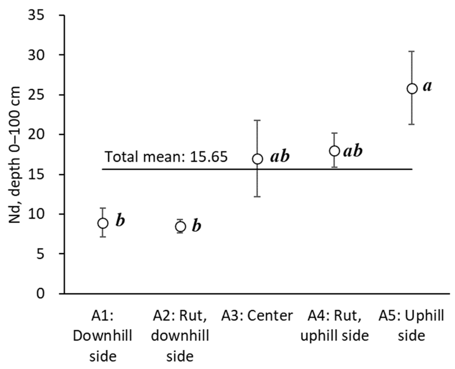
  • The roadbeds of the downhill sides tended to have lower strength because of insufficient compaction;
  • The result indicated that the excavation over the entire road width and even compaction were not properly performed on parts with lower strength;
  • Although it should be treated with caution, there appeared to be a tendency toward age-related change, i.e., natural compaction over time, for both the roadbed strength and the bearing capacity.
In the present study, the year of construction was treated as time elapsed since construction. However, in order to properly evaluate the strength development of a single pavement section, it is necessary to test the same pavement section at different ages. It would have been better to compare soil strength for three different depths, e.g., 0–30 cm, 30–60 cm, and 60–100 cm, to check the difference between fill and cut slopes and the effect of natural compaction. Although such analysis was not achieved in the present study because the resolution of Nd values was limited by the field situation, the authors would like to confirm the problem in the future study.
The lower strength of the roadbed on the downhill side of the spur roads or embankments was also observed in a related study on spur road construction. Furthermore, it was suggested that the soil under the road width should be excavated more widely toward the cut slope side before compaction to obtain the same roadbed strength on the downhill side as that on the cut slope side. Regarding the age-related change effect of the roadbed strength and bearing capacity, it was reported that in areas with low compaction ability soils, there is a spur road construction method that requires three years for completion. The method seems to effectively use the age-related change effect of the road strength. It is recommended that spur roads be left unused for a certain period of time before use in order to stabilize the materials of the constructed road body.

Author Contributions

Conceptualization, Y.S. and T.Y.; methodology, Y.S.; software, Y.S., S.H. and I.K.; validation, Y.S., S.H. and I.K.; formal analysis, Y.S., S.H. and I.K.; investigation, Y.S., S.H., H.A. and I.K.; resources, Y.S. and S.H.; data curation, Y.S. and S.H.; writing—original draft preparation, S.H. and I.K.; writing—review and editing, Y.S.; visualization, Y.S., S.H. and I.K.; supervision, Y.S.; project administration, Y.S.; funding acquisition, Y.S. and T.Y. All authors have read and agreed to the published version of the manuscript.

Funding

This study was supported by Japan Society for the Promotion of Science (JSPS) KAKENHI, grant numbers 21H03672, 22H03800, and 22K05747.

Data Availability Statement

The data used to support the findings of this study are available from the corresponding author upon request.

Acknowledgments

The authors are grateful to Ryohei Wada and Masa’aki Tateishi for supporting the field investigation in Site 2, and Naoyuki Hashimoto for supporting the GNSS survey in Site 2.

Conflicts of Interest

The authors declare no conflict of interest.

References

Note. The titles of Refs. [2,5,6,16,17,18,19,20,30,32,51,52,53] are tentative translations from the original Japanese by the authors.
  1. Gotou, J. Current status and challenges for forest operations with high density forest road networks. For. Econ. 2011, 63, 19–22. (In Japanese) [Google Scholar] [CrossRef]
  2. Japan Geotechnical Consultants Association. Geology and Geological Environment of the Japanese Islands—Geology of Japan and the West. Available online: https://www.zenchiren.or.jp/tikei/oubei.html (accessed on 31 December 2022). (In Japanese).
  3. Lyons, C.K.; Borz, S.A.; Harvey, C.; Ramantswana, M.; Sakai, H.; Visser, R. Forest roads: Regional perspectives from around the world. Int. J. For. Eng. 2022, 1–14. [Google Scholar] [CrossRef]
  4. Sakai, H. Challenges in Road Construction and Timber Harvesting in Japan. Croat. J. For. Eng. 2017, 38, 187–195. [Google Scholar]
  5. Forestry Agency. Development of Road Network Construction. Available online: https://www.rinya.maff.go.jp/j/seibi/sagyoudo/romousuisin.html (accessed on 30 December 2022). (In Japanese).
  6. Suzuki, Y.; Aruga, K.; Iwaoka, M.; Saito, M.; Sakurai, R.; Suzuki, H.; Hasegawa, H.; Matsumoto, T.; Yabe, K.; Yoshioka, T.; et al. Civil Engineering in Forestry, 2nd ed.; Asakura Publishing Co., Ltd.: Tokyo, Japan, 2021; 200p. (In Japanese) [Google Scholar]
  7. Suzuki, Y.; Setiawan, A.H.; Gotou, J. Timber Harvesting Systems in Japan’s Aging Plantation Forests: Implications for Investment in Construction of Forest Road Networks. J. Jpn. For. Soc. 2015, 97, 191–202, (In Japanese with English summary). [Google Scholar] [CrossRef]
  8. Suzuki, Y.; Yoshimura, T.; Hasegawa, H.; Aruga, K.; Saito, M.; Shirasawa, H.; Yamasaki, S. Perspective of road network improvement including public roads over forested area in Japan. J. Jpn. For. Eng. Soc. 2022, 37, 5–16. (In Japanese) [Google Scholar] [CrossRef]
  9. Dietz, P.; Knigge, W.; Löffler, H. Walderschließung; Paul Parley: Hamburg, Germany; Berlin, Germany, 1984; 426p. (In German) [Google Scholar]
  10. Heinimann, H.R. Forest Road Network and Transportation Engineering—State and Perspectives. Croat. J. For. Eng. 2017, 38, 173–188. [Google Scholar]
  11. Keller, G.; Sherar, J. Low-Volume Roads Engineering—Best Management Practices Field Guide; USDA Forest Service/USAID: Virginia Polytechnic Institute and State University, Blacksburg, VA, USA, 2003; 158p. Available online: http://hdl.handle.net/10919/68420 (accessed on 30 December 2022).
  12. Upfold, S. (Ed.) South African Forest Road Handbook; Forest Engineering Southern Africa and Institute for Commercial Forestry Research: Scottsville, South Africa, 2005; 214p, Available online: https://www.forestrysouthafrica.co.za/wp-content/uploads/2019/12/Roads-Handbook.pdf (accessed on 31 December 2022).
  13. Forestry Agency. Annual Report on Forest and Forestry in Japan—Fiscal Year 2021 (Summary). Available online: https://www.maff.go.jp/e/data/publish/attach/pdf/index-96.pdf (accessed on 5 January 2023). (In Japanese).
  14. Forestry Agency. Annual Report on Forest and Forestry for FY2021. Available online: https://www.rinya.maff.go.jp/j/kikaku/hakusyo/r3hakusyo/index.html (accessed on 5 January 2023). (In Japanese).
  15. Kanzaki, K.; Ohasi, K.; Deki, T.; Miyake, T. On capillary path systems in steep mountain areas. J. For. Eng. 1990, 2, 17–21. [Google Scholar] [CrossRef]
  16. Ohashi, K. All of Road Construction; Zenkoku-Ringyou-Kairyou-Fukyu-Kyokai: Tokyo, Japan, 2001; 159p. (In Japanese) [Google Scholar]
  17. Ohashi, K. Forestry Operation Road—Road Network Planning and Route Location; Zenkoku-Ringyou-Kairyou-Fukyu-Kyokai: Tokyo, Japan, 2011; 121p. (In Japanese) [Google Scholar]
  18. Ohashi, K. How to Observe Mountain and Forest; Zenkoku-Ringyou-Kairyou-Fukyu-Kyokai: Tokyo, Japan, 2012; 136p. (In Japanese) [Google Scholar]
  19. Ohashi, K. Inspection, Diagnosis, and Repair of Forest Road; Zenkoku-Ringyou-Kairyou-Fukyu-Kyokai: Tokyo, Japan, 2015; 112p. (In Japanese) [Google Scholar]
  20. Sakai, H. Operation Road: Theory and Environmental Protection Function; Zenkoku-Ringyou-Kairyou-Fukyu-Kyokai: Tokyo, Japan, 2004; 281p. (In Japanese) [Google Scholar]
  21. Umeda, S.; Suzuki, H.; Yamaguchi, S. Considerations in the construction of a spur road network. J. Jpn. For. Eng. Soc. 2007, 22, 143–152, (In Japanese with English summary). [Google Scholar] [CrossRef]
  22. Suzuki, Y.; Gotou, J.; Yamauchi, J.; Ohara, T. A case study on operational efficiency of downward felling, direct logging and winching operation on Hinoki plantation forest with dense road network and prospected effect of upward felling. J. Jpn. For. Eng. Soc. 2010, 25, 91–96, (In Japanese with English summary). [Google Scholar] [CrossRef]
  23. Nakahata, C.; Aruga, K.; Uemura, R.; Saito, M.; Kanetsuki, K. Examining the optimal method to extract logging residues from small-scale forestry in the Nasunogahara area, Tochigi prefecture, Japan. Small-Scale For. 2014, 13, 251–266. [Google Scholar] [CrossRef]
  24. Forest Survey. Training Material 2010 Construction of Forest Operation Roads; Forest Survey: Tokyo, Japan, 2010; 105p. (In Japanese) [Google Scholar]
  25. Sawaguchi, I.; Sugawara, D.; Sasaki, K.; Tatsukawa, S. The number of optimum compaction times of skidding roads banked using hydraulic shovels. J. Jpn. For. Eng. Soc. 2012, 27, 225–232, (In Japanese with English summary). [Google Scholar] [CrossRef]
  26. Watanabe, M.; Saito, M.; Shirasawa, H.; Ueki, T. The possibility of developing high-graded forest road networks by upgrading existing ones—A widening simulation-based investigation. J. Jpn. For. Eng. Soc. 2022, 37, 17–26, (In Japanese with English summary). [Google Scholar] [CrossRef]
  27. Ikoma, N.; Saito, M.; Tatsukawa, S. Grasping the actual state of skidding road in clear cutting with a vehicle logging system. J. Jpn. For. Eng. Soc. 2022, 37, 39–46. [Google Scholar] [CrossRef]
  28. Nagai, H.; Igarashi, S.; Takahashi, K.; Ichie, T. Evaluation of habitat selection by mammals in small vegetation patches of different forest physiognomies. Jpn. J. For. Environ. 2020, 62, 81–89, (In Japanese with English summary). [Google Scholar] [CrossRef]
  29. Suzuki, Y.; Kusaka, H.; Yamaguchi, Y.; Aoki, H.; Hayata, Y.; Nagai, H. Productivity of a harvesting operation for a small clear-cut block by direct grappling using a processor in the Kochi University Forest. Int. J. For. Eng. 2019, 30, 195–202. [Google Scholar] [CrossRef]
  30. Japan Meteorological Agency (JMA). Historical Weather Data Retrieval. Available online: https://www.data.jma.go.jp/obd/stats/etrn/index.php (accessed on 4 January 2023). (In Japanese).
  31. BizStation Corp. DG-PRO1—Single Band GNSS Receiver. Available online: https://www.bizstation.jp/en/drogger/gps_index.html?tab=product (accessed on 4 January 2023).
  32. Geological Survey of Japan, AIST. A Two-Hundred-Thousandth Seamless Geological Map of Japan. Available online: https://gbank.gsj.jp/seamless/ (accessed on 22 December 2022). (In Japanese).
  33. Suzuki, Y.; Yamauchi, K. Practical investigation on affiliate structures for prevention of disaster and degradation on low-standard forest roads. J. Jpn. For. Eng. Soc. 2000, 15, 113–124, (In Japanese with English summary). [Google Scholar] [CrossRef]
  34. Yamasaki, S.; Suzuki, Y.; Gotou, J.; Watanabe, N. Selection of terrain oriented appropriate logging system: A case study of the application on six watersheds in Kochi Prefecture, Japan. J. Jpn. For. Eng. Soc. 2021, 36, 13–20, (In Japanese with English summary). [Google Scholar] [CrossRef]
  35. Umeda, S.; Yoshida, M. Development of penetration test equipment for mountain slopes and its practical application. J. Jpn. For. Soc. 1986, 68, 180–189, (In Japanese with English summary). [Google Scholar] [CrossRef]
  36. Umeda, S.; Yoshida, M.; Takeshita, K. A standardization of the observed values obtained by various penetrometers on a mountain slope. J. Jpn. For. Soc. 1987, 69, 289–293, (In Japanese with English summary). [Google Scholar] [CrossRef]
  37. Yoshinaga, S.; Ohnuki, Y. Estimation of Soil Physical Properties from a Handy Dynamic Cone Penetrometer Test. J. Jpn. Soc. Eros. Control Eng. 1995, 48, 22–28, (In Japanese with English summary). [Google Scholar] [CrossRef]
  38. Gotou, J.; Yoshihara, O.; Mori, D.; Suzuki, Y. Considerations in the structure and the construction of spur roads for heavily loaded vehicles such as tower yarders. J. Jpn. For. Eng. Soc. 2014, 29, 5–12, (In Japanese with English summary). [Google Scholar] [CrossRef]
  39. The Japan Geotechnical Society, Committee for Standard of Geotechnical Survey. Japanese Standards and Explanations of Geotechnical and Geo-Environmental Investigation Methods; Volume 1 and 2; The Japan Geotechnical Society: Tokyo, Japan, 2014; 1259p. (In Japanese) [Google Scholar]
  40. Uchida, T.; Yahata, T.; Inagaki, M.; Kore’eda, K. Determination of Ground Bearing Capacity of Wide-Area Embankment Soils Using a Simple Penetration Tester. Proc. 15th Ann. Meet. Soil Mech. Geotech. Eng. 1980, 57–60. (In Japanese) [Google Scholar]
  41. Okimura, T.; Tanaka, S. Researches on Soil Horizon of Weathered Granite Mountain Slope and Failured Surface Depth in a Test Field. J. Jpn. Soc. Eros. Control Eng. 1980, 33, 7–16, (In Japanese with English summary). [Google Scholar] [CrossRef]
  42. Sugiyama, T.; Okada, K.; Noguchi, T.; Muraishi, H. Spatial Distribution Characteristics of Soil Strength in Embankment Surface. Doboku Gakkai Ronbunshu 1992, 1992, 33–40, (In Japanese with English Summary). [Google Scholar] [CrossRef] [PubMed]
  43. Ogawa, K. Study of Profile Patterns and Moisture Variations in Surface Soil Layers on Slopes of a Mountain Range. Res. BUll. Hokkaido Univ. For. 1997, 54, 87–141. Available online: http://hdl.handle.net/2115/21411 (accessed on 5 January 2023). (In Japanese with English Summary).
  44. Hiramatsu, S.; Bitoh, K. Study on easy set up method of input data to slope failure predicting model from a handy dynamic cone penetrometer. J. Jpn. Soc. Eros. Control Eng. 2001, 54, 12–21, (In Japanese with English summary). [Google Scholar] [CrossRef]
  45. Koyama, K. A new simple inspection method to check collapse at shoulder of spur road. J. Jpn. Soc. Eros. Control Eng. 2011, 64, 15–23, (In Japanese with English summary). [Google Scholar] [CrossRef]
  46. Kobayashi, H.; Fukuda, M. Some factors influencing bearing capacity of forest road surfaces. J. Jpn. For. Soc. 1975, 57, 135–143, (In Japanese with English summary). [Google Scholar] [CrossRef]
  47. Kobayashi, H.; Nitami, T.; Aruga, K.; Sakurai, R. On the Structure and Bearing Capacity of Forest Road. Bull. Univ. Tokyo For. 2005, 113, 241–256. Available online: http://hdl.handle.net/2261/22567 (accessed on 5 January 2023). (In Japanese with English summary).
  48. Suzuki, H.; Yamaguchi, S.; Muneoka, H.; Tanaka, Y.; Shimizu, N.; Kariya, Y. The influence of soil property on strength of strip road bed and road surface. J. Jpn. For. Eng. Soc. 2014, 29, 21–29, (In Japanese with English summary). [Google Scholar] [CrossRef]
  49. Sawaguchi, I.; Takahashi, Y.; Tatsukawa, S.; Takahashi, T. Aged change of bearing capacity of new construction skidding road. J. Jpn. For. Eng. Soc. 2011, 26, 97–104, (In Japanese with English summary). [Google Scholar] [CrossRef]
  50. Marui & Co., Ltd. Portable Bearing Tester “CASPFOL”. Available online: https://www.marui-group.co.jp/en/products/items2_4/item2_4_3/ (accessed on 3 January 2023).
  51. Ministry of Land, Infrastructure and Tourism, Kinki Regional Development Bureau. Simplified Bearing Capacity Measuring Instrument (CASPFOL) User’s Guide. Available online: https://www.kkr.mlit.go.jp/kingi/kensetsu/gijutusien/bcu0ke0000002vrs-att/caspol_guide.pdf (accessed on 31 December 2022).
  52. Japanese Geotechnical Society. Soil Testing Practice Manual. In Soil Testing—Basics and Guidance, 3rd ed.; Japanese Geotechnical Society: Tokyo, Japan, 2001; 251p. (In Japanese) [Google Scholar]
  53. Taguchi, G. The Design of Experiments, 3rd ed.; Vols. I and II.; Maruzen: Tokyo, Japan, 1977; 1095p. (In Japanese) [Google Scholar]
  54. Zar, J.H. Biostatistical Analysis, 4th ed.; Prentice-Hall Inc.: Upper Saddle River, NJ, USA, 1999; 663p. [Google Scholar]
Figure 1. Study site. Site 1: A spur road constructed in FY 2013–2016 in the west block, Site 2: A spur road constructed in FY 2019–2021 in the east block of Kochi University Forest.
Forests 14 00380 g001
Figure 2. Spur road construction in Kochi University Forest using the Shimanto method. The soil was dug over once with additional depth, and then compacted with layers of 20–30 cm thickness. (a) Example of the cross-section of the middle-grade slope (e.g., 20°) natural ground. (b) On a steeper natural ground slope (e.g., 30°), the embankment volume and fill slope length tend to be larger. (c) In such cases, the center line of the spur road is shifted to the uphill side in order to decrease the embankment volume. The cut slope can be constructed as vertical if its maximum height is less than the limit height of 1.4 m.
Forests 14 00380 g002
Figure 3. Example of spur road construction in Kochi University Forest during a training course. The excavator dug over the soil for extra depth (a). Then, the loose soil was mixed using the bucket, spread over the designated road width (b), and compacted by the crawler (c). The compaction was carried out for a few layers with a thickness of 20–30 cm each up to the level of the existing road height (d).
Forests 14 00380 g003
Figure 4. Doken-type dynamic penetrometer. Standardized design of the Doken-type dynamic penetrometer (a) (the Japan Geotechnical Society, Committee for Standard of Geotechnical Survey 2014 [36]). The soil strength is measured by striking the hammer at a height of 500 mm (bd) with the road kept vertical. By measuring the penetration depth by each strike or a few strikes, the penetrated depth is converted into an Nd value, which represents the number of strikes required for a depth of penetration of 10 cm.
Forests 14 00380 g004
Figure 5. In-situ CBR measuring instrument (CASPFOL). Schematic diagram of CASPFOL (a) [51]. The acceleration of the rummer is measured by the instrument when the rummer falls and strikes the soil (b,c). The soil strength is measured by striking the rummer at a height of 500 mm with the road kept vertical through the built-in acceleration meter. The standard measuring method requires five measurements around a designated point with a 20 cm radius (d).
Forests 14 00380 g005
Figure 6. Measuring points on the spur road at each sample point of Site 1.
Forests 14 00380 g006
Figure 7. Measuring points on the spur road at each sample point of Site 2.
Forests 14 00380 g007
Figure 8. Grain size distribution of soil sampled at Sites 1 and 2.
Forests 14 00380 g008
Figure 9. Main effect of Factor A, relative position within the road width, of Site 1 on the Nd -value. The error bars represent the standard error (SE). Different letters indicate significant differences between the population means. Tukey test, p < 0.01, n = 24.
Forests 14 00380 g009
Figure 10. Main effect of Factor B, fiscal year of construction, of Site 1, on the Nd -value. The error bars and different letters have the same meaning as in Figure 9. p < 0.01, n = 25 except for B3 (n = 20).
Forests 14 00380 g010
Figure 11. Nd—values of Site 1 accompanied with thresholds.
Forests 14 00380 g011
Figure 12. Interaction of Factor A (relative position) and Factor C (fiscal year of construction) of Site 2 on the Nd—value. The error bars and different letters have the same meaning as in Figure 9. p < 0.01, n = 8.
Forests 14 00380 g012
Figure 13. Interaction of Factor B (downhill side or uphill side), Factor C (fiscal year of construction), and Factor D (penetrating depth) of Site 2 on the Nd -value. The error bars and different letters have the same meaning as in Figure 9. p < 0.01, n = 6. B1: Downhill side, B2: Uphill side; D1: 0–50 cm, D2: 50–100 cm.
Forests 14 00380 g013
Figure 14. Nd—values of Site 2 accompanied with thresholds.
Forests 14 00380 g014
Figure 15. Interaction of Factor C (fiscal year of construction), Factor R (repetition), and Factor B (downhill side or uphill side) of Site 2 on in-situ CBR. The error bars and different letters have the same meaning as in Figure 9. p < 0.05, n = 5. B1: Downhill side, B2: Uphill side.
Forests 14 00380 g015
Table 1. Descriptive statistics of Study Site 1: a spur road in the west block of Kochi University Forest.
Fiscal Year of Construction (Years Elapsed at Survey)Length (m)Average Gradient of the Road (%)Num. of Measured PointsAverage Road Width (m)Average Cut Slope Height (m)Average Cut Slope Gradient (deg.)Average Fill Slope Gradient (deg.)Average Slope of Adjacent Natural Ground (deg.)
2013-1(4.2)182.33.552.91.168.737.222.8
2013-2(4)98.7−5.552.91.265.538.224.0
2014(3)87.6−0.243.11.268.851.025.0
2015(2)100.213.453.21.662.145.828.1
2016(1)156.7−4.553.11.476.843.829.6
Sum625.5 24
Total mean 1.2 3.01.368.442.926.0
STD 0.50.414.312.36.5
Max. 4.82.390.069.041.1
Min. 2.60.536.918.414.3
Fiscal year of survey: 2017 (November 2017–January 2018).
Table 2. Descriptive statistics of Study Site 2: a spur road in the east block of Kochi University Forest.
Fiscal Year of Construction (Years Elapsed at Survey)Length (m)Average Gradient of the Road (%)Num. of Measured PointsAverage Road Width (m)Average Cut Slope Height (m)Average Cut Slope Gradient (deg.)Average Fill Slope Gradient (deg.)Average Slope of Adjacent Natural Ground (deg.)
2019(2)41.811.022.81.352.441.223.5
2020(1)73.821.123.00.971.656.322.1
2021(0.5)134.615.442.70.662.945.420.5
Sum250.2 8
Total mean 16.3 2.80.962.547.121.7
STD 0.30.38.48.12.6
Max. 3.01.371.656.323.5
Min. 2.40.552.439.517.9
Fiscal year of survey: 2021 (November 2021–January 2022).
Table 3. ANOVA table of Nd in Site 1.
FactorDegree of FreedomSum of SquaresVarianceF-Valuep-Value
A: Relative position within road width45783.11445.86.740.00
B: Fiscal year of construction46587.81647.07.680.00
Error (pooled)11123,807.1214.5
Total11936,614.2
Total mean: 15.65.
Table 4. ANOVA table of Nd in Site 2.
FactorDegree of FreedomSum of SquaresVarianceF-Valuep-Value
A: Relative position21028.0514.04.310.02
B: Downhill side or uphill side1787.0787.06.600.01
C: Fiscal year of construction31783.8594.64.990.00
D: Penetrationg depth13098.43098.425.980.00
A × B2803.9401.93.370.04
A × C63140.2523.44.390.00
B × C31472.3490.84.120.01
A × B × C61563.4260.62.190.05
B × C × D31408.5469.53.940.01
Error (pooled)688108.4119.2
Total9523,193.9
Total mean: 9.79.
Table 5. ANOVA table of in-situ CBR in Site 2.
FactorDegree of FreedomSum of SquaresVarianceF-Valuep-Value
B: Downhill side or uphill side1315.2315.223.000.00
C: Fiscal year of construction3433.0144.310.530.00
R: Repetition145.345.33.310.07
B × C × R3155.851.93.790.01
Error (pooled)71973.013.7
Total791922.3
Total mean: 14.5%.
Disclaimer/Publisher’s Note: The statements, opinions and data contained in all publications are solely those of the individual author(s) and contributor(s) and not of MDPI and/or the editor(s). MDPI and/or the editor(s) disclaim responsibility for any injury to people or property resulting from any ideas, methods, instructions or products referred to in the content.

